Embed Size (px)
Citation preview

NEHALEM BAY STATE PARKMASTER PLAN
October 2009

ii NEHALEM BAY STATE PARK
The mission of the Oregon Parks and Recreation Department is to provide and protect outstanding natural, scenic, cultural, historic and recreational sites for the enjoyment and education of present and future generations.
Oregon Parks & Recreation Department725 Summer St. NE, Ste C
Salem, OR 97301-0792Info Center: 1-800-551-6949
egov.oregon.gov/OPRD/index.shtml
Title: Nehalem Bay State Park Draft Master Plan

OCTOBER 2009 MASTER PLAN iii
S E C T I O N T I T L EACKNOWLEDGEMENTS
OPRD Director: Tim Wood, Director Kyleen Stone, Assistant Director, Recreation Programs and Planning
OPRD Staff: Ron Campbell, Master Planning Coordinator John Allen, Region 1 Manager Mike Stein, District Manager Larry Oswald, Park Manager Mark Smith, Former Park Manager Kathy Schutt, Master Planning Manager Carrie Lovellette, Division Assistant Brady Callahan, GIS Program Coordinator Dave Quillin, GIS Technician Terry Bergerson, SCORP Planner Noel Bacheller, Natural Resource Specialist / Botanist Jay Schleier, Natural Resource Specialist / Wildlife Biologist Danae Whipp, Graphics Technician
Advisory Name Affi liationCommittee: Bill Campbell, Former Director Tillamook County Community Development
Garry Bullard, Mayor City of ManzanitaDale Stockton, Council President City of NehalemTom Dye Tillamook County ParksMichelle Long, Fisheries Biologist ODFWMacy Yates, Recreation Unit Supervisor ODF Tillamook DistrictJulie Chick, Water Trail Coordinator Tillamook Estuaries PartnershipLarry Weber Oregon Dept. of AviationChris Cummings Oregon Dept. of AviationRobert Kentta Confederated Tribes of SiletzDavid Lewis Confederated Tribes of Grand RondeMark Beach CartM RecyclingJohn Hajny Oregon Equestrian TrailsChad Allen Oregon Shores Conservation CoalitionGeorgenne Ferdun, Chair Lower Nehalem Community TrustTom Bender Sustainable Architecture & Economics
Diane Getty Neighbor Randall Henderson Pilot
Dave Godsey, Former Council Coordinator Lower Nehalem Watershed CouncilSarah Newton, Council Coordinator Lower Nehalem Watershed CouncilIan Madin, Chief Scientist DOGAMIKen Upshaw, Port Commissioner Port of NehalemGeorge Urrey Tillamook County Public Works
Other Thanks to other OPRD and SHPO staff who contributed information, insight and ideas Contributors: including: Nancy Nelson, Dave Wright, Richard Walkoski, Darrell Monk, Jamie Little,
Rocky Houston, Laurel Hillmann, Marina Creswell, Amy Gillette Andy Smogor, and John Potter.
Contacts: Larry Oswald, Park Manager 503-368-5943Ron Campbell, Master Planning Coordinator 503-986-0743Kathy Schutt, Master Planning Manager 503-986-0745

iv NEHALEM BAY STATE PARK

OCTOBER 2009 MASTER PLAN v
S E C T I O N T I T L ETABLE OF CONTENTS
TABLE OF CONTENTS
I. MASTER PLAN SUMMARY ...............................................................................1
II. MASTER PLANNING PROCESS ........................................................................5
III. PLANNING CONTEXT ........................................................................................9
IV. EXISTING CONDITIONS ..................................................................................17
V. HERITAGE ASSESSMENT ................................................................................25
VI. RECREATION NEEDS & OPPORTUNITIES ....................................................33
VII. SUITABILITY ASSESSMENTS .........................................................................37
VIII. ISSUES .................................................................................................................45
IX. GOALS AND STRATEGIES ...............................................................................53
X. DEVELOPMENT CONCEPTS ...........................................................................59
XI. NATURAL, CULTURAL & SCENIC RESOURCE MANAGEMENT ..............85
XII. SUMMARY OF LAND USE APPROVAL REQUIREMENTS ........................103
APPENDIX A - WILDLIFE SPECIES ...............................................................105

vi NEHALEM BAY STATE PARK

OCTOBER 2009 MASTER PLAN vii
S E C T I O N T I T L EMAPS & ILLUSTRATIONS
MAPS & ILLUSTRATIONS
Vicinity Map ......................................................................................................................13
Study Area Map. ................................................................................................................15
Road Access Map ...............................................................................................................19
Existing Facilities: Nehalem Bay State Park North ..........................................................21
Existing Facilities: Nehalem Bay State Park South ..........................................................23
Composite Suitability: Nehalem Bay State Park North ....................................................41
Composite Suitability: Nehalem Bay State Park South ....................................................43
Illustration 1: Development Areas & Circulation Plan .....................................................75
Illustration 2: North Campground & Day Use Concept ...................................................77
Illustration 3: Cabin Village Concept...............................................................................79
Illustration 4: South Campground & Day Use Concept ...................................................81
Illustration 5: Central Campground Concept ....................................................................83
Habitat Concepts: Nehalem Bay State Park North ...........................................................91
Habitat Concepts: Nehalem Bay State Park South ...........................................................93

viii NEHALEM BAY STATE PARK
Additional Nehalem Bay State Park Master Plan Documents
The following background documents were prepared as support for the Nehalem Bay State Park Master Plan:
Resource Maps of the Park:
• Plant Communities and Conditions (2 maps)
• Water Features (2 maps)
• At-Risk Species (2 maps)
• Cultural Resource Sensitive Areas (2 maps)
• Topography (2 maps)
• Hazards (2 maps)
Background Reports:
• “Vegetation Inventory and Mapping, Nehalem Bay State Park and the Cougar Valley Complex of Undeveloped Property.” (Duck Creek Associates, Inc., 2006)
The above documents may be viewed at:
Oregon Parks and Recreation Department 725 Summer Street NE, Suite C Salem, OR 97301
OCTOBER 2009 MASTER PLAN 1
GOALS AND STRATEGIESI. MASTER PLAN SUMMARY
I. MASTER PLAN SUMMARYThis master plan serves as guidance for future development, public use and resource management at Nehalem Bay State Park. Included in the master plan are summaries of the issues, resource assessments, recreation needs, goals and strategies, development proposals and resource management guidelines associated with the park, and the process followed in formulating and adopting the master plan. The goals and strategies, development concepts and resource management guidelines are intended to provide for an appropriate balance of park resource protection and public recreation access. Planned recreational opportunities at the park are designed to be compatible each other, neighboring land uses, and the park’s important natural, cultural and scenic resources.
Nehalem Bay State Park occupies roughly 1,152 acres at the mouth of the Nehalem River between the ocean shore and the Nehalem Bay estuary in Tillamook County, a short distance from Highway 101. It is one of OPRD’s seven campground parks in the north coast region, which reaches from the Columbia River to Newport, and one of fi ve campground parks in the region that front on the ocean shore. Visitation rates are consistently high and the campground is consistently fi lled during the summer months. Along with the tourists, residents of the neighboring communities value the recreation opportunities offered by the park, just as the tourists value the amenities offered by the neighboring towns. Most of the park visitors are campers and day visitors seeking ocean beach recreation activities. Campsite choices include conventional sites for recreational vehicles or tents, yurts and a hiker/biker camp. This is also a popular park for equestrian activity, featuring a beachfront equestrian camp, horse rental concession and riding trails. A small meeting hall and a campfi re program area supplement the camping and day use activities. The park also has
a small airport, a unique feature for a state park, with several primitive campsites used by aviators. A paved loop trail is popular for walking and biking. The park’s boat launch facilities are also very popular, especially during the salmon fi shing seasons.
Most of the park’s sand spit and dune formations were unvegetated until planting for dune stabilization began in the 1950’s utilizing European beach grass, Scotch broom and coast pine species. These plant species now largely dominate the vegetation patterns over most of the park. European beach grass, Scotch broom, Himalayan blackberry, Japanese knotweed and English ivy, which are all invasive non-natives, continue to spread and threaten to alter the more viable native habitats. The most valuable native habitats are associated with the shorelines, numerous wetlands, and the older mixed native conifer forests on the higher dune ridges, some with trees as old as 200 years. Certain habitats continue to support rare plant species, such as the endangered pink sand-verbena. The remote south end of the park has been planned for restoration of western snowy plover nesting habitat under OPRD’s Habitat Conservation Plan for this endangered bird, which was last observed in the park around 20 years ago. The setting between the open ocean and the bay, coupled with the low elevation of most of the park landscape, make it susceptible to natural hazards of storm surges, tsunamis and ocean and river fl ooding.
Why a New Master Plan is NeededSeveral factors prompted the master planning process. Nehalem Bay is one of two state parks in the north coast region that has room to expand camping facilities to help meet the growing unmet demand. OPRD’s campground parks on the north coast are consistently fi lled during the summer, and many visitors are turned away. OPRD is also seeking to diversify the types of campsites

2 Nehalem Bay State Park
TITLE
offered at the park to accommodate a wider range of visitor preferences. A draft interpretive plan for Nehalem Bay and several surrounding state parks has also recently been completed. The interpretive plan identifi es Nehalem Bay as a hub for interpretation of the area’s rich natural and cultural history for visitor education and enjoyment, and proposes development of a modest-sized interpretive center at this park. A number of archeological sites in the park have been documented, and additional archeological investigations are being planned. While these sites need protection from potential disturbance, the information they provide supports OPRD’s efforts to educate the public about the area’s cultural history. A master plan is needed to appropriately locate and design new facilities and to establish a balance between natural, cultural and scenic resource management objectives and recreation uses.
Master Plan Proposals If the plan is fully implemented, the number of campsites in the park, 313 existing sites, would increase up to 54% for a total of up to 481 sites. The changes include: a new yurt village; a new cabin village; a new group camp loop; relocation of the equestrian camp loop; conversion of the existing equestrian camp to a conventional camp loop; two new tent camps with clustered parking; relocation and expansion of the hiker biker camp; a new remote hike-in camp; expansion of the fl y-in camp; and a new paddle-in camp along the bay shore.
Planned additions to the boating and bay access facilities include a small parking area for river trail paddlers, a fi shing and crabbing dock, a mowed area to accommodate overfl ow parking, a boat wash station, a fi sh cleaning station and upgraded utilities.
Additions to other day use areas are planned, including a new northern beach access parking area, expansion of the meeting hall and redesign of its parking area, and expansion of the southern beach access picnic area including two new picnic shelters.
Planned expansion of the park’s interpretive facilities includes an expanded program area, a new interpretive center building, interpretive trails, and a traditional Native American long house developed in cooperation with affi liated tribes.
The park’s administrative facilities are also planned for expansion, including development of a new visitor welcome and registration center near the park entrance, new single family residences for year-round staff, cabins to house seasonal staff, and a number of new park host RV sites.
Some new road development and road realignment will accompany the new facility development, which will improve vehicular circulation.
The plan also proposes expansion of the park-wide trail system, including connections to the neighboring communities and the Oregon Coast Trail.
Various projects are proposed to improve habitat conditions, with primary emphasis on invasive weed control and habitat for rare and endangered species.
Key IssuesIn the process of formulating the master plan, comments were gathered from the general public, an advisory committee, local offi cials and OPRD staff. The comments supplemented OPRD’s assessments of park resource conditions prepared as background information for planning decisions. Among the numerous factors considered in making planning decisions, several key issues stand out.

OCTOBER 2009 MASTER PLAN 3
GOALS AND STRATEGIESI. MASTER PLAN SUMMARY
The public road system leading to the park entrance is badly in need of improvements to accommodate the existing and future traffi c. The master plan commits OPRD to contribute a fair share to the cost of needed road improvements, including a separated bike and pedestrian path, and to defer any development that would signifi cantly increase park traffi c until such improvements are provided.
Rapid evacuation would be critical in a major emergency such as a tsunami. Most of the park visitors are concentrated in areas that would be inundated in such an event. The master plan commits OPRD to update the evacuation plan in cooperation with affected emergency response service providers, and make any related improvements, before implementing any projects that would signifi cantly increase park visitation.
The Oregon Department of Aviation (ODA) is updating the Statewide Airport Systems Plan, which includes recommendations that pertain to the functions of the Nehalem Bay airport. The importance of the airport for emergency response operations, pilot safety in unpredictable coastal weather patterns and other safety factors, in addition to the use it gets for fl y-in recreation, were highlighted in many comments received early in the master planning process. The master plan supports continued operation of the airport and allows improvements needed to maintain its functions and enhance its use for recreation access.
Shoreline erosion is causing the bay shoreline to progressively recede toward the end of the airport runway and the park road. The master plan calls attention to this issue and recommends follow-up coordination with affected agencies to determine what kind of corrective action would be feasible and appropriate.
Master Plan HorizonPark facility development such as planned for Nehalem Bay commonly takes 20 years to fully implement. Habitat management projects often take much longer to yield noticeable benefi ts. This master plan establishes a direction for park development and management based on current information while allowing reasonable fl exibility to adapt to new or refi ned information as it becomes available.

4 Nehalem Bay State Park
TITLE

OCTOBER 2009 MASTER PLAN 5
GOALS AND STRATEGIESII. MASTER PLANNING PROCESS
II. MASTER PLANNING PROCESSThis chapter provides an overview of the process followed in formulating and adopting a park master plan. A more complete description of the planning process is found in OPRD’s administration rules cited below.
AuthorityOPRD prepares master plans for its properties under the authorities embodied in state statutes and rules, which include ORS 390.180, OAR 736 Division 18, ORS 195.120 and OAR 660 Division 34.
PurposeThe purpose of a state park master planning process is to plan for both the protection and public enjoyment of the resources that occur in each park being master planned. Master plans identify and provide for the most appropriate recreational uses based on resource opportunities and constraints, development opportunities and constraints, public recreation needs, and OPRD’s roles as a statewide outdoor recreation provider. A master plan may also identify lands that OPRD would consider acquiring from willing sellers to add to the state park, as well as any lands that are under OPRD ownership that should not be part of the state park. A master plan also provides a basis for preparing partnership agreements, budget and management priorities and detailed development and management guidelines, and for requesting land use approvals from affected local governments for planned projects.
Products of a Master Planning Process
A park master plan is a written and illustrated ��reference containing summarized information about, and long term plans for the park. It serves as a guide for the parks 20-year future.Contained in the master plan are summaries of the planning purpose and process, existing park facilities, future recreation demand, the suitability of the land for recreational uses or resource protection, issues related to public use and management, the goals, strategies and development concepts for future use and development in the park, and guidelines for managing the park resources.

6 Nehalem Bay State Park
TITLE
Development concepts in the master plan ��show how to fi t needed facilities into the park. These are the conceptual blueprints for the park. The development concepts refl ect the resource constraints and opportunities and address the goals and stategies established in the planning process. They describe the appropriate types, sizes, locations and access for the proposed facilities.Resource maps, prepared as background ��information for the master plan depict locations of natural, cultural and scenic resources in the park. These maps are used frequently by park staff, other resource agencies and interest groups and park “friends” groups. They provide a basis for resource management and development decisions. The master planning process is an opportunity ��for the public to discuss and provide input on the future of the park. The process includes several public meetings and mailings and invites the public to provide comments on the pertinent issues and the proposals and guidelines for the park.Partnership opportunities are often identifi ed. ��The planning process is an opportunity to encourage partnerships with other agencies, interest groups and neighbors to benefi t park implementation and management.
Process for Completing a Master PlanIn the fi rst steps of the planning process, information is gathered on the park’s natural, cultural and scenic resources, existing park uses and facilities, recreation needs and opportunties and interpretive opportunties, as well as information about the local community.
Issues involving the use, development and management of the park property are identifi ed through meetings with department staff, an advisory committee, affected local government offi cials and the general public.
Goals and strategies for future use and development of the park and management of the park resources are determined. Resource management guidelines and development concepts for the park are formulated.
All of the above information is compiled into a draft master plan that is reviewed by department staff, the advisory committee, the interested public, and by the OPRD Director and the Oregon Parks and Recreation Commission. Comments are collected and the master plan is edited based on guidance from the Director and Commission.
The draft master plan is checked for compatibility with the state land use goals and local comprehensive plans in consultation with local government planning offi cials. If the master plan is determined to be compatible, the draft plan is then presented for adoption as a state rule. Additional comments are received from the public in a formal rule-making hearing, which sometimes leads to additional edits prior to fi nal adoption.
If the draft master plan is not compatible with local plans, OPRD takes steps necessary to achieve compatibility, either by making appropriate changes in the master plan or by requesting pertinent changes in the local plans through the appropriate land use application process. The master plan cannot be adopted as a state rule until it is compatible with local land use plans.

OCTOBER 2009 MASTER PLAN 7
GOALS AND STRATEGIESII. MASTER PLANNING PROCESS
Master Plan Implementation and AmendmentsOnce the park master plan is adopted as a state rule, any development in the park must be consistent with the master plan. Minor variations from the adopted master plan may be allowed if such variations are determined by the OPRD Director and the affected local government to be consistent with the master plan in accordance with OAR 736-018-0040. Any use that is not consistent with the master plan requires a master plan amendment. Master plan amendments must follow the same process used to adopt the master plan, which includes re-adoption as a state rule and a determination of compatibility with local government comprehensive plans.
Park master plans are amended when changes in circumstances are signifi cant enough to warrant changes. The OPRD Director considers the recommendations of OPRD staff and outside interests in prioritizing the park master plans to be adopted or amended each biennium. The director’s decisions are based on consideration of various factors, such as:
Recreation demands that affect the park, and •opportunities in the park to help meet the demands;The need for signifi cant changes in park uses •or facilities to improve park functions;Signifi cant changes in the conditions of, or •threats to, natural, cultural or scenic resources within or surrounding that park where a master plan amendment is needed to address the changed conditions or threats; Confl icts or potential confl icts between park •uses and neighboring land uses where a master plan amendment is needed to address the confl icts;
Opportunities to establish partnerships to •implement previously unplanned projects that fi t the park setting.Alternatives to amending the master plan that •would adequately address needed changes, such as interagency management agreements, partnerships, etc.

8 Nehalem Bay State Park
TITLE

OCTOBER 2009 MASTER PLAN 9
GOALS AND STRATEGIESIII . PLANNING CONTEXT
III. PLANNING CONTEXTThis chapter summarizes the context of the park setting in relation to other state and County recreation lands, facilities and activities and OPRD’s roles as a public recreation provider.
The “Vicinity” map at the end of this chapter illustrates the location of Nehalem Bay State Park relative to the surrounding communities, transportation system, major water bodies and other state parks. A larger scale “Study Area” map that shows the park on an aerial photo base is also included at the end of this chapter.
Nehalem Bay State Park is located on the Tillamook County coast at the mouth of the Nehalem River between the ocean shore, which defi nes the park’s west boundary, and the Nehalem Bay estuary which forms the east boundary. The park’s southern tip is formed where the river fl ows to the ocean. The urban growth areas of Manzanita and Nehalem border the park to the north. County and city roads provide access to the park.
Other State Parks on the Tillamook County Coast
The Tillamook County Coast has a total of 12 state parks including Nehalem Bay. Two of these have campgrounds, of which Nehalem Bay is the largest. (See the “Existing Conditions chapter for a description of the facilities at Nehalem Bay.)
Cape Lookout has the other state park campground in the County, with 38 full hookup sites and one with electricity only, 173 tent sites, 13 yurts, three deluxe cabins, four group tent areas and a hiker/biker camp, as well as a meeting hall, group picnic area, trail to the cape and beach access.
With two exceptions, the day use state parks in Tillamook County are also on the ocean shore. Oswald West State Park offers beach access and trails including 13 miles of the Oregon Coast Trail. Cape Meares State Scenic Viewpoint features the Cape Meares lighthouse. Clay Meyers State Natural Area occupies most of a small island in the Sand Lake estuary, and features a trail around the island and a large estuarine marsh. Cape Kiwanda State Natural Area features wave sculpted cliffs, tidepools and dunes. Bob Straub State Park, on the Nestucca River sand spit, offers trails and beach access. Beach access and picnic sites are offered at Manhattan Beach, Oceanside Beach and Neskowin Beach State Recreation Sites. Munson Creek Falls State Natural Site, located inland and east of Highway 101, features the highest waterfall in the Coast Range. Cougar Valley State Park, located about 17 river miles up the Nehalem River, was recently added to the state park system. This park currently has no developed facilities for public access, except a graveled one-lane forest road.
Tillamook State Forest Recreation Sites
The Tillamook State Forest, administered by the Oregon Department of Forestry (ODF), is situated between the Portland Metro Area and the coast. Historically the State Forest has attracted signifi cant numbers of campers, anglers, hunters and off highway vehicle enthusiasts, as well as equestrians and other recreation interests. ODF provides a number of trailheads for motorized and non-motorized trail uses, mostly in the Wilson River drainage. The Trask River drainage also has a trailhead and an OHV staging area and two boat ramps administered by ODF.
ODF administers two developed campgrounds and a number of dispersed campsites in the Nehalem River drainage. The largest is Henry Rierson Spruce Run Campground, located on the Nehalem River in Clatsop County along Lower Nehalem River Road and south of Highway 26. Spruce Run has 37 campsites, fi ve of which are walk-in sites,
10 Nehalem Bay State Park
TITLE
and a small day use area. The second is Nehalem Falls Campground located at the falls just over a mile upriver from Cougar Valley State Park. This campground has 19 total campsites, which include one group site and four walk-in sites, as well as a small day use area. Ten dispersed riverfront campsites are situated downriver from Spruce Run, and thirteen more are situated along the lower reaches of Cook Creek.
Additional campgrounds are administered by ODF in the Wilson River drainage. Jones Creek Campground has 39 campsites of which nine are walk-in sites and one is a group site. Elk Creek Campground has 15 sites, all of which are walk-in sites. Gales Creek Campground has 23 campsites which include 4 walk-in sites.
The Stagecoach Horse Camp in the Wilson River drainage, also administered by ODF, offers 11 campsites for equestrians and access to the historic Wilson River Wagon Road Trail. Three OHV campgrounds and staging areas are also located in this drainage. Jordan Creek OHV Campground has 6 campsites, Browns Camp has 29 campsites, and Lydia Camp and Diamond Mill staging areas offer dispersed camping for OHV users.
A river access for non-motorized boating known as the Beaver Slide, located directly across the river from Cougar Valley State Park on ODF land, is managed under an agreement with the Oregon Department of Fish and Wildlife.
Tillamook County Parks
The Tillamook County Parks Department administers seven parks with campgrounds and several day use parks. Barview Jetty Park, located at the outlet of Tillamook Bay, has 69 RV campsites, 219 tent sites, group campsites and a hiker/biker camp. Whalen Island Park, which occupies the southern end of Whalen Island and is adjacent to Clay Meyers State Natural Area, has 30 campsites, a day use and picnic area and
a boat launch. Kilchis River Campground on the Kilchis River offers 60 RV or tent campsites, a day use area and a boat launch. Trask River Park on the Trask River offers 59 RV or tent campsites, a hiker/biker camp and a day use area. On the Nestucca River the County administers Woods Park, which has fi ve RV campsites, three tent sites and a group use shelter. Webb Park is situated on the ocean shore next to Cape Kiwanda and has seven RV campsites and 33 tent sites. Roy Creek Park, located on the Nehalem River, has a graveled boat ramp and parking.
OPRD’s Role as a Statewide Recreation Provider
OPRD’s Mission is to:
“Protect and provide outstanding natural, scenic, cultural, historic and recreational sites for the enjoyment and education of present and future generations.”
OPRD master plans help to accomplish the OPRD mission by establishing the goals and strategies, development concepts and resource management guidelines for each park that strike a balance between recreational use and development and resource protection.
The Oregon State Parks System has provided Oregon’s residents and visitors with reputable park services since its initiation in 1929. Originally, the department saw its role as a protector of the scenic resources related to highway travel and emphasized land acquisition. From the department’s fi rst land acquisition in 1929 until now, OPRD has acquired over 95,000 acres of diverse, historic and scenically treasured public land. This is largely due to OPRD’s origin within the early State Highway Division. OPRD did not become a separate department from the later Oregon Transportation Department until 1989. Much of OPRD’s role has been shaped by its connection with Oregon’s highway locations

OCTOBER 2009 MASTER PLAN 11
GOALS AND STRATEGIESIII . PLANNING CONTEXT
and their enjoyment. The early park system was built upon a framework of roadside rest areas and scenic corridor preserves.
Developed overnight camping facilities were not available in Oregon’s state parks until the 1950s. The demand for such facilities began to boom in the post WWII period. OPRD expanded its role to include recreation development beyond just rest area facilities to include campgrounds and more developed day use and swim areas. Today OPRD has 53 parks with overnight accommodations.
As life styles have changed so have approaches to camping, and OPRD has tried to diversify the types of camping provided in its parks. The current OPRD role for camping includes providing tent sites, full RV hookup sites, hiker-biker sites and close by, walk-in tent camping. Very few OPRD properties offer dispersed or pack-in camping. Most OPRD camps are considered to be “high amenity” within a scenic setting, including fl ush toilets, showers and access to water, garbage and electricity somewhere in the camp. The camps are generally not far from a state highway. In recent years, OPRD has been constructing yurts or cabins in many of its larger camping parks in an effort to extend the camping season. Group camping and horse camping are also popular and growing in state parks across the state.Another common OPRD role is providing high quality grounds and facilities for accessing adjacent resources such as lakes, ocean beaches, rivers and other attractions. Again, the parks are generally not far from a state highway and include developed facilities with vehicular access.
In the 1970’s, with the advent of a variety of natural and cultural resource protection laws, OPRD discovered that its scenic lands and traditional access sites were also high quality natural and cultural resources. Master planning for protection and public access to OPRD’s parks began in the 1970’s to address this emerging dual role.
OPRD’s role was also expanded in the 1970’s with the adoption of Willamette River Greenway legislation and Statewide Goal 15. More than 90 properties along the Willamette River have been added to the state park system since the beginning of the Greenway program. Most of these parklands are managed in a primitive state for their natural, scenic and primitive recreation values, and many have no upland access. A few larger parks were identifi ed for regional park development associated with the Greenway.
In recent years OPRD has been acquiring a few very high quality natural and cultural areas for the purpose of protecting and restoring their resource values and providing appropriate levels of public access for recreation and interpretive purposes.

12 Nehalem Bay State Park
TITLE

06
53
131
101
101
101
26
ELSIEELSIE
MOHLERMOHLER
NETARTSNETARTS
BARVIEWBARVIEW
WHEELERWHEELER
ENRIGHTENRIGHT
NEHALEMNEHALEM
BAY CITYBAY CITY
ROCKAWAYROCKAWAY
BRIGHTONBRIGHTON
TILLAMOOKTILLAMOOK
OCEANSIDEOCEANSIDE
GARIBALDIGARIBALDI
PATTERSONPATTERSON
MANZANITAMANZANITA
ALDERVALEALDERVALE
ARCH CAPEARCH CAPE
TWIN ROCKSTWIN ROCKS
CANNONCANNONBEACHBEACH
SEASIDESEASIDE
Nehalem Bay State Park
Oswald West SP
Saddle Mountain SNA
Ecola State Park
ElmerFeldenheimer SNA
Cougar ValleyState Park
Cape MearesSSV
Hug Point SP
Manhattan BeachState Wayside
Symons SSV
Arcadia Beach SRS
Haystack Hill SSV
Twin RocksState Wayside
Foss Rd
Mia
mi F
oley
Rd
Tin Shack Rd
Lowe
r Neh
alem
Rd
Cook Creek Rd
Wilson River
Miami River
Kilchis River
Necanicum River
Salmonberry River
Trask
River
Little
Nort
h Fork
Wilso
n Rive
r
North F
ork N
ehale
m Rive
r
Nehalem River
PPaa
ccii
ffii
ccOO
ccee
aann
TILLAMOOK
CLATSOP
Nehalem Bay State Park
Vicinity Map 0 2 41 Miles

14 Nehalem Bay State Park
TITLE

Neh
alem
Bay
Neh
alem
Bay
North Fork Nehalem River
North Fork Nehalem River
Cook Creek
Cook CreekFoley Creek
Foley Creek
Nehalem RiverNehalem River
Lost Creek
Lost Creek
MOHLERMOHLER
WHEELERWHEELER
NEHALEMNEHALEM
BRIGHTONBRIGHTON
BATTERSONBATTERSON
MANZANITAMANZANITA
ROCKAWAYROCKAWAY
53
101
101
Oswald West SPOswald West SP
Nehalem Bay Nehalem Bay State ParkState Park
Cougar ValleyCougar ValleyState ParkState Park
Manhattan BeachManhattan Beach State Wayside State Wayside
Neahkahnie-Neahkahnie-Manzanita SRSManzanita SRS
Nehalem Bay State Park
Study Area
0 8,0004,000 Feet
Note: This product was produced for conceptual Note: This product was produced for conceptual planning purposes. It was not prepared for, and mayplanning purposes. It was not prepared for, and maynot be suitable for, legal, engineering or surveying not be suitable for, legal, engineering or surveying purposes. Users of this information should reviewpurposes. Users of this information should reviewthe primary data sources to ascertain the usabilitythe primary data sources to ascertain the usabilityof the information.of the information.


OCTOBER 2009 MASTER PLAN 17
GOALS AND STRATEGIESIV. EXISTING CONDITIONS
IV. EXISTING CONDITIONSThis chapter summarizes the current conditions that characterize the park and its immediate surroundings. A more detailed description of the park’s natural resource conditions is provided in Chapter V - “Heritage Assessment.”
Landscape CharacterNehalem Bay State Park consists of approximately 1152 acres of stable and conditionally stable coastal dune and sand spit formations between the ocean shore and the Nehalem Bay estuary. Elevations in the park range from sea level up to roughly 160 feet. A level defl ation plain covered with forest, woodland and shrubland vegetation occupies the largest part of the park. Pine forests with exotic beachgrass and scotch broom understory dominate the vegetation communities, refl ecting the dune stabilization efforts of the past. Many wetlands are present in the depressions on the defl ation plain. The foredune is mostly covered with beachgrass. Mature and more diverse native conifer forests cover the much older and taller dune ridge along the bay and in the northwest portion of the park.
The NeighborhoodThe park is surrounded by the ocean and river estuary along most of its boundary length. The immediate neighborhood lies entirely to the north of the park. Most of the adjacent lands are developed or targeted for development for residential uses within the urbanized and future urban growth areas of Manzanita and Nehalem. A non-profi t recycling operation, a driving range and a cemetery are also located along the primary access road to the park.
Access to the ParkNecarney City Road serves as the primary vehicular access route from Highway 101 to the main park entrance. This road is under County and City jurisdictions. It is used beyond its capacity and is badly in need of improvements. Pedestrians and bicycles share the roadway, as there are no pedestrian or bicycle lanes.
An alternate route leading to the main park entrance is identifi ed in the City of Manzanita Downtown Transportation Plan. This route follows Classic Street and Ridge Road from the downtown area to a connection with Necarney City Road. The City’s Plan proposes that this route become a primary connection between Highway 101 and the park with improvements to its intersection with the highway.
Another City road, Horizon Lane, connects the southernmost beachfront residential area of Manzanita to the west boundary of the park. This route to the park is used by some local residents. Tourists who are familiar with this route sometimes use it to travel between the park and downtown Manzanita.
A small airport managed by the State Department of Aviation (ODA) occupies part of the park. It is classifi ed as a Level 5, Remote Access / Emergency Services airport. This is a unique feature in the state park system. While the overall use of the airstrip is apparently low, it is used for various purposes such as responding to medical emergencies, pilot training, Coast Guard rescue operations and emergency landings in addition to providing access for fl y-in camping and other coastal recreation.

18 Nehalem Bay State Park
TITLE
ZoningNehalem Bay State Park is zoned “Recreation Management” (RM) under Tillamook County’s zoning ordinance. This zone provides for a broad range of recreational uses and facilities. Several overlay zones also apply to portions of the park property. These overlays implement provisions of the state land use goals that pertain to protection of beaches and dunes, estuaries, coastal shoreland habitats and fl oodplains. The master plan will be reviewed by the County prior to its adoption to assure that the uses planned for the park are compatible with the zoning regulations.
Existing Recreation Uses and FacilitiesThe aerial photo maps at the end of this chapter illustrate the approximate locations of the park boundaries and exiting park facilities.
Nehalem Bay State Park boasts one the highest visitation rates in the state park system, offering a wide range of day use and overnight recreation opportunities. Activities at Nehalem Bay include:
Camping in RVs or tents��Camping in yurts��Horseback riding and equestrian camping��Hiker/biker camping��Fly-in camping��Beach activities��Picnicking��Group gatherings indoors and outdoors��Easy hiking��Bicycling��Fishing��Boating, both motorized and non-motorized��Attending campfi re programs��Participation in Junior Ranger Program��
The existing visitor facilities at Nehalem Bay include:
265 campsites with electricity and water��18 yurts��Campfi re program area ��Meeting hall��Horse camp with 17 primitive campsites��Horse rental concession��Hiker / biker camp with 7 tent sites��Fly-in camp with six tent sites��Paved bike trail��Unpaved multi-use trails��Boating access with launch ramp, courtesy ��dock and parkingDay use beach access parking��Picnic area��Playgrounds for campers��Restrooms with fl ush toilets and showers��RV dump station��

0 250 500 1,000Feet
0 250 500 1,000Feet
Park Entrance
Existing County Road Access
Proposed Alternate Road Access
Horizon Ln
Nec
arne
y Bl
vd.
Laneda Ave. Clas
sic
St.
Necarney City Rd.
Ridg
e Dr
.
101
Park Boundary
ROAD ACCESSNEHALEM BAY STATE PARK
June 2009

20 Nehalem Bay State Park
TITLE

NNEE
HHAA
LLEE
MM
BB
AAYY
Group ShelterGrou Shelter
RegistrationRegistrationBoothBooth
ParkingParking
Hiker Biker Hiker Biker CamCam
Water TankWater Tank
Park Manager sPark Manager sResidenceResidence
MaintenanceMaintenanceAreaArea
AirstriAirstri
Parking AreaParking Area
Cam LooCam LooAA
Cam LooCam LooBB
Cam LooCam LooCC
Cam LooCam LooCam LooCam Loo
EE
Cam LooCam Loo
Horse CamHorse CamRestroom ShowerRestroom Shower
Restroom ShowerRestroom Shower
RestroomRestroom
RV Waste umRV Waste um
PlaygroundPlayground
Cam ire ProgramCam ire ProgramParking AreaParking Area
Cam ire ProgramCam ire ProgramAreaArea unior Rangerunior Ranger
Meeting AreaMeeting Area
Restroom ShowerRestroom Shower
PlaygroundPlayground Restroom ShowerRestroom Shower
Primiti e Cam sitesPrimiti e Cam sites
Boat RamBoat Ram
Boat TrailerBoat TrailerVehicle ParkingVehicle Parking
Courtesy ockCourtesy ock
RestroomRestroom
Picnic AreaPicnic Area
ParkingParking
RestroomRestroom
Horse Rental AreaHorse Rental Area
Sta ParkingSta Parking
Gar age BinsGar age Bins
Gar ageGar ageBinsBins
Picnic AreaPicnic Area
ay-useay-useRegistrationRegistration
Note: This product was produced for conceptual Note: This product was produced for conceptual planning purposes. It was not prepared for, and mayplanning purposes. It was not prepared for, and maynot be suitable for, legal, engineering or surveying not be suitable for, legal, engineering or surveying purposes. Users of this information should reviewpurposes. Users of this information should reviewthe primary data sources to ascertain the usabilitythe primary data sources to ascertain the usabilityof the information.of the information.
Pu ic Access RoadsPu ic Access Roads
Maintenance RoadsMaintenance Roads
Walkway or SidewalkWalkway or Sidewalk
Hiking TrailHiking Trail
Biking TrailBiking Trail
Horse TrailHorse Trail
ppro imate ar oundaryppro imate ar oundary
00 0000 , 00, 000000FeetFeet
Existing Facilities
Nehalem Bay State ParkNorth Half
November 008


NN EE HH AA LL EE MM BB AA YY
Horse TrailHorse Trail
Approximate Park BoundaryApproximate Park Boundary
Note: This product was produced for conceptual Note: This product was produced for conceptual planning purposes. It was not prepared for, and mayplanning purposes. It was not prepared for, and maynot be suitable for, legal, engineering or surveying not be suitable for, legal, engineering or surveying purposes. Users of this information should reviewpurposes. Users of this information should reviewthe primary data sources to ascertain the usabilitythe primary data sources to ascertain the usabilityof the information.of the information.
00 600600 1,2001,200300300FeetFeet
Existing FacilitiesNehalem Bay State Park
South Half
December 2008

OCTOBER 2009 MASTER PLAN 25
GOALS AND STRATEGIESV. HERITAGE ASSESSMENT
V. HERITAGE ASSESSMENTThis chapter provides a summary of key resource inventories and assessments that were used in completing the master plan. Detailed mapping of key resources contributed to the completion of the Composite Suitability Assessment, discussed in the “Suitability Assessments” chapter, and the guidelines for park resource management and restoration discussed in the “Natural, Cultural and Scenic Resource Management Guidelines” chapter. Detailed maps and other background information on the park resources are fi led at the OPRD headquarters offi ce in Salem. The resource maps are also kept on fi le at the Nehalem Bay State Park Offi ce.
The Nehalem Bay State Park Landscape
Most of the park’s approximately 1,152 acres are characterized by sand dune and sand spit formations bordered by the ocean shore to the west and the Nehalem Bay estuary to the east. The profi le of the spit reaching inland toward the bay begins with a sparsely vegetated beach that transcends to a foredune which gives rise to a well-established defl ation plane. Small depressions throughout the defl ation plane result in wetlands of varying sizes. On the narrow spit the defl ation plane gives way to a lesser developed foredune on its eastern side that is bordered by a sparsely vegetated beach along the bay. Toward the north end of the park the much older dune formation that borders the bay reaches over 160 feet elevation at the highest point. Geologically, the dunal formations of the park overlay alluvial deposits from the Holocene period which are comprised mainly of silt, sand, and to a lesser extent, gravel.
The Changing Landscape at Nehalem Bay
The history of the Nehalem Bay area since the arrival of Euro-Americans in the nineteenth century is one of rapid change. The bay has decreased in overall area and water depth as a result of human activities. The diking and draining of the bay in order to increase agricultural capacity has led to a decrease in the overall area of the bay, while accelerated erosive forces resulting from agricultural practices, logging, and forest fi res have led to increased sedimentation and a corresponding decrease in the depth of the bay. Jetties constructed at the river mouth in an effort to improve navigability across the river bar has somewhat changed the pattern of erosion and accretion along the ocean shore.
Change at the park is pervasive not only in the area and depth of the surrounding bay, but also in the vegetation pattern and ecological processes.While some of the mature spruce forests in the northern portion of the park and scattered forested hummocks along Nehalem Bay have remained relatively unchanged since Euro-American settlement, the majority of the vegetation of the park has been altered. This has led to corresponding changes in the landforms.
Historically, the dunes at Nehalem Bay supported signifi cantly less vegetation than they do today. Vast areas of sparsely vegetated sand dunes were ubiquitous. Trees clung to isolated patches of higher ground while shifting low-lying dunes sparsely covered with native grasses made-up the predominant plant communities. Presumably, American dunegrass was the dominant graminoid species on the shifting dunes. The less extensive and developed defl ation planes of that era supported depressions that fl ooded with fresh or brackish water and gave rise to various wetland plant communities.

26 Nehalem Bay State Park
TITLE
Planting for dune stabilization began on the Oregon Coast in the 1930s by utilizing non-native European beach grass, Scotch broom, and coast pine. Efforts to stabilize the dunes arose from the incompatibility of shifting blowing sand and regional development. Before dune stabilization occurred, sand blocked roads and created havoc for some residents and visitors to the coast.Plantings for dune stabilization at Nehalem Bay State Park, which began around the 1950s, have successfully stabilized the dunes. This has taken some time, however. In the early 1970s the park’s nickname was still “Sandblast State Park,” referring to lots of blowing sand and little vegetation.
The stabilization effort signifi cantly altered the plant communities and the topography of the dunes. Planting of European beachgrass and its subsequent spread has contributed to less wind erosion and a taller foredune. The decomposition of European beachgrass has led to increased nutrients on the foredune that allowed it to support more vegetation, which in turn trapped more sand blowing from the beach causing the dune to grow and cutting off the sand supply to the interior dune. Consequently the defl ation plane, the landform on the leeward side of the foredune, has increased substantially in width over the last 50 years. The larger portion of Nehalem Bay State Park is now a densely vegetated defl ation plane.
Plant Communities at Nehalem Bay
The master planning process included a study of the plant associations that now occur in the park. Plant associations were mapped and described by their species composition and conditions. These maps, titled “Plant Communities and Conditions,” and the companion report titled “Vegetation Inventory and Mapping, Nehalem Bay State Park and the Cougar Valley Complex of Undeveloped Property,” are included with the background documentation for the master plan.Current vegetation patterns at Nehalem Bay State
Park largely refl ect dune stabilization efforts. European beachgrass and Scotch broom, both invasive non-native species, are widely present, leaving the native vegetation in largely degraded condition over large areas. Wetland habitat is fragmented in the park, but is mostly in good condition. Other invasive non-native species that are of particular management concern are also contributing to the degraded conditions of the native communities. Himalayan blackberry is widespread throughout the park, and English ivy and Japanese knotweed are found in more manageable quantities. A single plant of pink sand-verbena, a state listed endangered species and a federal species of concern, was found along the foredune.
The wide northern portion of the park where the majority of the park facility development is located is also the most forested area. The narrow spit south of this area is a mix of woodland, shrubland, and herbaceous habitat types. Mature native conifer forests that are in good or excellent condition and of high conservation value occur in the northern part of the park along the bay shore and north of the campground area. Sitka spruce and shore pine are dominant among these forests, with lesser amounts of western hemlock and Douglas fi r.
The dominant plant community in the park is the shore pine/Scotch broom/European beachgrass association. This mostly early to mid-seral association occupies the defl ation plane landform throughout the park, having developed from plantings for dune stabilization and supplemented through seed dispersal. Maritime pine, a non-native pine used with shore pine for dune stabilization, is mixed with the shore pine in some associations and is dominant in some areas.
The beach areas are sparsely vegetated with the exception of the northeastern beach along the bay, where the habitat type is herbaceous. The foredune along the ocean shore is also herbaceous, dominated by European beachgrass. American

OCTOBER 2009 MASTER PLAN 27
GOALS AND STRATEGIESV. HERITAGE ASSESSMENT
dunegrass is dominant on the leeward side of the foredune along the western edge of the defl ation plane where it transitions into the wooded and shrubland areas of the defl ation plane. This native community is mixed between good and marginal condition, and if left unmanaged, will likely be replaced by European beachgrass over time.
Of the various wetland plant associations, the shore pine/slough sedge forested wetland type covers the most area. It is scattered throughout the park, but is best represented in the northern area between and adjacent to the campground and airstrip. Most of these communities are in good condition. Another relatively common wetland type found in the park is the slough sedge/Pacifi c silverweed association. These wetlands are mostly located in the southern part of the park, the largest of which is in excellent condition. Another wetland type that occupies a large area is the three-square bulrush tidal herbaceous association,located at the upland-estuary interface in the northeast portion of the park. It is also in excellent condition. A somewhat unique wetland type, also in excellent condition and found exclusively in the northern part of the park, is the Douglas spiraea shrub wetland. The least represented of all the wetland types is the creeping spikerush/Nevada rush association. This community, also in excellent condition, is located on the narrow spit and is surrounded by a large slough sedge/Pacifi c silverweed community.
The least represented of all upland plant communities is the red fescue association. It is found in a small opening surrounded by a shore pine/Douglas-fi r/wax myrtle-evergreen huckleberry association in the north of the park.
With the exception of the high quality and mature native conifer communities in the northern part of the park and along the bay shore, nearly the entire park is in a vastly altered vegetative state from what would have been its native condition. It is speculated that the shifting dunes may have fostered scattered pockets of American dunegrass,
red fescue, seashore bluegrass, and a variety of herbs such as beach pea, seashore lupine, beach silvertop, coast strawberry, and gray beach pea. These communities have been replaced by European beachgrass, Scotch broom, and other weedy species such as sweet vernal grass, colonial bentgrass, common velvetgrass, sheep sorrel and false dandelion.
Wildlife (Also see Appendix A.)
Wildlife habitat types at Nehalem Bay State Park were identifi ed based on the assessment of plant communities summarized above and described in detail in the background report titled “Vegetation Inventory and Mapping, Nehalem Bay State Park and the Cougar Valley Complex of Undeveloped Property.”
Wildlife species that are associated with various habitat types found in the region are reported in the reference by Johnson and O’Neil titled “Wildlife-Habitat Relationships in Oregon and Washington.” This reference lists the species of mammals, birds, reptiles and amphibians that are closely associated with, generally associated with, or commonly present in each type of habitat.
Nehalem Bay State Park has seven of the habitat types described in the Johnson and O’Neil reference. Appendix A of this master plan lists the wildlife species that are “closely associated” with each of these habitat types as reported by Johnson and O’Neil. The lists were edited for their relevance to the park setting by OPRD’s Wildlife Biologist. The following habitat types occur in the park setting:
Westside Lowland Conifer – Hardwood ��ForestCoastal Dunes and Beaches��Westside Riparian – Wetlands��Herbaceous Wetlands��Open Water – Lakes, Rivers and Streams��Bays and Estuaries��Urban and mixed Environs��

28 Nehalem Bay State Park
TITLE
At-Risk Species Known to Occur or Potentially Occurring at Nehalem Bay State Park
Birds Occurrence Status
Bald eagle (Haliaeetus leucocephalus)
A pair nests at Nehalem Bay State Park along the bay shore.
Recently removed from federal ESA listing. Delisting under state ESA currently pending.
Fish -- (Present in the adjacent estuarine habitat.) Occurrence Status
fall & summer Chinook salmon (Oncorhynchus tshawytscha)
Nehalem River lower reach provides migratory habitat.
Not “at-risk” but fi sh runs are highly valued for protection.
coho salmon (Oncorhynchus kysutch)
Nehalem River lower reach provides migratory habitat.
Federally and state listed “threatened.”ONHIC List 1.
winter steelhead (Oncorhynchus mykiss)
Nehalem River lower reach provides migratory habitat.
Federal “species of concern.” State “sensitive-vulnerable.” ONHIC List 1.
coastal cutthroat trout (Oncorhynchus clarkii)
Nehalem River lower reach provides migratory habitat.
Federal “species of concern.” State “sensitive-vulnerable.” ONHIC List 4.
Pacifi c lamprey (Lampetra tridentate) Present in the bay and river during life stages
Federal “species of concern.” State “sensitive-vulnerable.” ONHIC List 4.
chum salmon (Oncorhynchus keta)
Nehalem River lower reach provides migratory habitat.
State “sensitive-critical.”ONHIC List 2.
Plants Occurrence Status
pink sandverbena (Abronia umbellata ssp. Brevifl ora)
One plant found along the ocean shore at Nehalem Bay. Suitable habitat occurs at other open sand / sparsely vegetated sites.
Federal “species of concern”. State listed “endangered”. ONHIC List 1.
yellow sandverbena (Abronia latifolia)
Found in numerous locations on the beach at the south end of the spit at Nehalem Bay. Suitable habitat occurs at other open sand / sparsely vegetated sites.
ONHIC List 4.
largehead sedge (Carex macrocephala)
Found in numerous locations on the beach at the south end of the spit at Nehalem Bay. ONHIC List 4.
bog anemone (Anemone oregana var. felix)
None found, but suitable habitat occurs in wetlands along the bay shore at Nehalem Bay.
Federal “species of concern”. ONHIC List 1.
Pt. Reyes bird’s-beak (Cordylanthus maritimus ssp. palustris)
None found, but suitable habitat occurs in wetlands along the bay shore at Nehalem Bay.
Federal “species of concern”. State listed “endangered”.ONHIC List 1.
manyleaf gilia (Gilia millefoliata) None found, but suitable habitat occurs in wetlands along the bay shore at Nehalem Bay. Federal “species of concern”.

OCTOBER 2009 MASTER PLAN 29
GOALS AND STRATEGIESV. HERITAGE ASSESSMENT
At-Risk Species
“At-risk” species are species that meet one of the following criteria:
Currently listed as “threatened” or 1.“endangered” under state or federal Endangered Species Acts (ESA);
Candidate for listing as “threatened” or 2.“endangered” under state or federal ESA;
Not “threatened” or “endangered, or candidate 3.for such listing, under state or federal ESA, but considered to be “at risk” as indicated by inclusion on a state or federal watch list.
Information on at-risk plant species was provided in the background report titled “Vegetation Inventory and Mapping, Nehalem Bay State Park and Cougar Valley Complex of Undeveloped Property.” The study conducted for this report included fi eld investigations.
Information on at-risk fi sh and wildlife species was gathered from existing data sets provided by the Oregon Natural Heritage Information Center (ONHIC) and supplemented by information provided by the Oregon Department of Fish and wildlife (ODFW).
Exotic Species
Weeds at Nehalem Bay
Three invasive exotic plant species of concern were mapped at Nehalem Bay: Himalayan blackberry (Rubus discolor), English ivy (Hederahelix), and Japanese knotweed (Polygonumcuspidatum).Himalayan blackberry is the most commonly encountered invasive species, occurring in a wide variety of population sizes throughout the park. It is generally regarded as impractical to eradicate on a large scale. This species is also abundant in areas adjacent to the park, and if it could be eradicated from the park, would likely re-colonize the park through seed dispersal.
English ivy, while not as abundant as Himalayan blackberry, has spread over large areas in some locations, particularly in the shore pine-Sitka spruce/evergreen huckleberry plant association.
Japanese knotweed, the least extensive of the three mapped exotics, occurs in the park in small groups or as individual plants along Nehalem Bay in sparsely vegetated areas. It is also found on other lands upriver, which suggests there will always be a seed source to colonize the bay shore in the park.
European beachgrass and scotch broom are now widespread at Nehalem Bay since their introduction for dune stabilization. Removal of these species on a large scale is generally regarded as impractical. In most of the affected areas, management actions are generally limited to controlling further spread. Large sites where these species are predominant are identifi ed on the “Plant Communities and Conditions” maps. In addition, the background report that accompanies these maps identifi es numerous plant communities where these species occur in the composition of the plant associations.
Other exotic species that have degraded herbaceous native plant communities include salt rush, bird’s-foot trefoil, reed canarygrass, quackgrass, hairy catsear, spikerush and daggerleaf rush. In forested areas, other exotic species include plantain, clover, daisy and false dandelion.
Natural Hazards
Nehalem Bay State Park is one of many coastal attractions that are vulnerable to the natural hazards associated with the coastal shoreland setting. Most of the park property is situated on stable or conditionally stable coastal dune and sand spit formations between the Nehalem Bay estuary and the open ocean.
The foredune height protects most of the park from ocean fl ooding in major storm surges.

30 Nehalem Bay State Park
TITLE
However, winter storms coupled with high river fl ows and tides have caused rapid erosion of the bay shoreline where the main body of the park meets the narrow sand spit. Examination of historic aerial photos indicates that this shoreline has receded by more than 200 feet in the past 35 years. About 35 feet of recession has occurred within the past three years, which has removed the last of the tree and shrub cover between the shoreline and the airport runway.
The threat of a tsunami caused by an off-shore earthquake is potentially the most devastating, albeit rare, type of ocean fl ood event that threatens the park, its facilities and its visitors. The State Department of Geology and Mineral Industries (DOGAMI) has modeled the wave generation expected to result from such an event, and roughly estimated and mapped the expected geographic extent of resulting ocean fl ood inundation. This information is scheduled to be updated in the next few years based on refi ned modeling by DOGAMI. The current information indicates that nearly all of the existing visitor facilities in the park, as well as the airport, would be inundated if a major tsunami occurred.
The low-lying coastal location of the park also makes it vulnerable to fl ooding caused by global warming and rising sea levels.
Wildland fi res are also noteworthy as a natural, although usually human caused, threat. This hazard is mainly of concern where human activity occurs among understory vegetation dominated by scotch broom, especially where this very fl ammable shrub thrives among a sparse canopy of shore pine and maritime pine.
Recreation Settings
OPRD has adopted methodology for assessing different types of recreational settings. Known originally as Recreation Opportunity Spectrum (ROS), the methodology was fi rst developed by the US Forest Service and was later adapted by
OPRD to address the somewhat different range of settings that are present outside of the federal lands in Oregon. The methodology is documented by OPRD in the Statewide Comprehensive Outdoor Recreation Plan (SCORP), 1994-1999.
Using OPRD’s adapted ROS methodology, Nehalem Bay State Park may best be described, although not perfectly, within the following range of ROS classifi cations:
Urban within Open Space: Describes a largely developed setting with paving and buildings, highly maintained vegetation, heavy interaction and visitor controls, within an open space context.
Roaded Modifi ed: Describes a setting that is a forest or other natural environment with obvious modifi cations such as logging or mining, road access and limited facility development, within an open space context. Social interaction is moderate.
Roaded Natural: Describes a setting that is an apparently unmodifi ed natural environment, with road access through or adjacent and limited facility development, within an open space context. Social interaction is moderate.”
Scenic Resources
The scenic qualities of the park setting are important to the recreation experience of the visitors, from the perspectives of the ocean shore, the river and bay, and the park lands. Several types of scenic views need consideration in designing visitor access:
Boaters on the Nehalem River and Bay enjoy ��the varied river bank character and natural vegetation scenery of the park landscapes from these perspectives. Views of the bay and its shoreline are seen ��from the park road and trail system at certain locations. Many visitors enjoy the panoramic views of the bay and its shoreline while using the sand beaches on the bay side of the park.

OCTOBER 2009 MASTER PLAN 31
GOALS AND STRATEGIESV. HERITAGE ASSESSMENT
Visitors on the ocean shore enjoy the ��panoramic views of the ocean and shoreline.
Cultural Resources
Evidence of cultural resources has been found at several sites at Nehalem Bay State Park. Investigation reports for these sites are fi led with the State Historic Preservation Offi ce (SHPO). OPRD staff worked with SHPO to inventory documented archeological sites and to review the related investigation reports. Pursuant to state law, this information is not available for public review. Prior to implementing any projects involving ground disturbing activities, OPRD will be required to follow protocols set out under SHPO authorities. For certain sites these protocols may require further investigations prior to ground disturbance. Any important archeological resources that may be encountered anywhere at anytime in the parks will be protected according to state laws. OPRD is also consulting with affi liated tribes on matters concerning identifi cation, protection and interpretation of cultural resource sites in the park.

32 Nehalem Bay State Park
TITLE

OCTOBER 2009 MASTER PLAN 33
GOALS AND STRATEGIESVI. RECREATION NEEDS AND OPPORTUNITIES
Recreation Demand
The SCORP includes estimates of annual recreation use, by activity, for each of the SCORP planning regions. The estimates were based on the Oregon Outdoor Recreation Survey conducted over a one-year period from February 2001 to January 2002 by Oregon State University’s College of Forestry. Recreation participation estimates for individual activities were measured in “user occasions.” A user occasion is defi ned as each time an individual participates in a single outdoor recreation activity. The table below shows 2002 annual participation estimates for SCORP Planning Region 1 for activities associated with the park settings.
2002 Recreation Demand in Region 1: User Occasions by Activity
Recreation Activity
2002 UserOccasions
Picnicking 637,321Fishing from boat 1,198,193Fishing from bank or shore 757,909Fishing from dock or pier 272,936Crabbing from dock or pier 227,961Canoeing 165,542Bird watching 1,943,404Nature/wildlife observation 1,797,447Ocean beach activities 4,693,793Bicycle camping 23,041RV/trailer camping 3,728,795Car camping with tent 348,762Biking on surfaced trails 112,931Biking on unsurfaced trails 35,663Hiking on surfaced trails 92,083Hiking on unsurfaced trails 581,430Horseback riding on trails (all surfaces) 112,821
Running/walking for exercise on trails (all surfaces) 213,061
Walking for pleasure on trails (all surfaces) 313,710
VI. RECREATION NEEDS & OPPORTUNITIESThe master planning process included an assessment of recreation needs and opportunities related to the park settings. Needs and opportunities were assessed based on a review of the following information sources: 1) The 2003-07 Statewide Comprehensive Outdoor Recreation Plan (SCORP); 2) The 2004 Oregon Statewide Trail User and Non-motorized Boater Survey; 3) The Oregon Trails, 2005-2014, Statewide Action Plan; 4) OPRD Acquisition Priorities Report, 2006.
In addition, information gathered from the Nehalem Bay State Park Planning Advisory Committee, OPRD fi eld staff and the general public in the issue scoping process were factored into the needs and opportunities assessment.
The proposals in this master plan respond to identifi ed recreation needs with recreation access facilities that are appropriate for the Nehalem Bay State Park setting.
SCORPThe Statewide Comprehensive Outdoor Recreation Plan (SCORP), 2003-2007, provides statewide and regional information on key issues, recreation demand and participation trends for a wide range of outdoor recreation activities. SCORP data are reviewed together with other indicators of need for recreation access facilities. Nehalem Bay State Park is in SCORP Region 1, which encompasses Clatsop, Tillamook, Lincoln and coastal Lane Counties. Following are key issues, indicators of recreation demand and participation trends as reported in the SCORP for Region 1 that are relevant to activities existing or under consideration for Nehalem Bay State Park.

34 Nehalem Bay State Park
TITLE
Recreation Trends
Another method of identifying recreation facility needs is to make comparisons of how recreation participation for a comparable set of activities changes over time. For the 2003-2007 SCORP analysis, 2002 recreation participation estimates from the Oregon Outdoor Recreation Survey were compared to the participation estimates from the 1986-1987 Pacifi c Northwest Outdoor Recreation Survey prepared for the 1988 to 1993 SCORP. Direct comparisons for the full range of activities reported in the SCORP were not possible due to differences in the ways the data were collected in these two surveys. However, direct comparisons were possible for the following activities that pertain to Nehalem Bay State Park.
Beach activities, RV/trailer camping and day hiking are among the fi ve top growth activities for Region 1 as reported in the SCORP.
Top Funding Issues Identifi ed for SCORP Region 1
Top issues for each SCORP planning region were identifi ed in a series of 11 regional workshops conducted in 2001. Each regional workshop included two sessions, one for recreation providers and the other for the general public. The top issues for Region 1 identifi ed in workshops and reported in the SCORP are:
Funding for campgrounds��Funding for river access��Funding for non-motorized trails and trail ��connections
Changes in Recreation Participation in Region 1 from 1987 to 2002
Recreation Activity 2002 User Occasions
1987 User Occasions
%Change
Day hiking 993,897 550,399 80.6%Horseback riding 150,428 107,989 39.3%Fishing from boat 1,198,193 1,189,028 0.8%Non-motorized boating (ocean, lake, river) 298,694 549,767 -45.7%
Beach activities 6,041,082 3,306,923 82.7%Nature/WildlifeObservation 1,797,447 1,417,282 26.8%
RV/trailer camping 3,728,795 1,994,422 87.0%
Car camping with tent 348,762 729,796 -52.2%
Picnicking 637,321 1,358,640 -53.1
Outdoor Recreation Needs – Quantitative Analysis
A central component of the SCORP is the quantitative comparison of outdoor recreation demand and supply of existing recreation resources and facilities, across all of the recreation providers in a region. In this analysis, a recreational facility need is identifi ed when recreation participation exceeds the current supply. (Note: This analysis does not address differences in demand for different destinations within a region, such as state parks versus national forest sites.)
Two of the top three outdoor recreation facility needs identifi ed for SCORP Region 1 in this analysis include:
Surfaced and unsurfaced hiking and multi-use ��trailsFishing and crabbing docks and piers��
Oregon Statewide Trail User and Non-motorized Boater Survey
The 2004 Oregon Statewide Trail User and Non-motorized Boater Survey was conducted over a 4-month period from January to April by the University of Oregon’s Survey Research Laboratory. This survey was conducted in support of the Oregon Trails, 2005-2014, Statewide Action Plan. Its purpose was to assess the needs and

OCTOBER 2009 MASTER PLAN 35
GOALS AND STRATEGIESVI. RECREATION NEEDS AND OPPORTUNITIES
opinions of Oregonians about trail opportunities and management, and the need for future investment in trail facilities and opportunities, and provide trail planners with statistically reliable information pertaining to local and regional trails planning. Among the key fi ndings of this survey were the following, which pertain to the park setting:
Non-motorized trail use:Thirty three percent of Oregon households ��(approximately 438,500 households) had a person reporting non-motorized trail use during the year preceding the survey.Hiking and walking for pleasure were the ��most popular trail activities among the non-motorized trail users.
Non-motorized boating:Fourteen percent of Oregon households ��(approximately 185,200 households) had a person reporting non-motorized boating participation during the year preceding the survey.Among non-motorized boaters, canoeing ��and drift boating were among the three most popular activities.
Oregon Trails, 2005-2014, Statewide Action PlanPublic Workshop ResultsIn 2003 OPRD conducted a series of 9 regional public workshops across the state to discuss the major issues that affect the provision of non-motorized trail and water trail opportunities in Oregon, as a basis for formulating the Oregon Trails, 2005-2014, Statewide Action Plan. Each regional workshop was held in two sessions, one for recreation providers and the other for the general public.
For the northwest region of the state, the following were identifi ed as top issues, which are relevant to the provision of non-motorized trail and water trail opportunities at Nehalem Bay.
Top issues regarding provision of non-motorized trail opportunities included:
The need for trail connectivity within the ��region, providing access from urban to rural trails, connections between public facilities, parks and open space and connections from state and regional trails to community trails.Need for additional non-motorized trails ��for all user types, especially close to where people live.
Top issues regarding provision of non-motorized water trail opportunities included:
Need for more public access to waterways.��
OPRD Acquisition Priorities Report, 2006OPRD’s statewide Acquisition Priorities Report is based on a compilation of information gathered in various studies that guide the Department in planning and providing for outdoor recreation opportunities, including the studies discussed above. In addition, in preparing this report OPRD conducted a State Park Capacity Analysis to help determine with greater certainty where there are shortages of state park lands and facilities. OPRD staff gathered hard data on visitation and occupancy rates for state park campgrounds and compared them to a capacity index used to indicate whether a park is considered to be “over capacity.” For day use parks, staff conferred with fi eld managers to identify parks where day use parking lots are regularly fi lled to capacity on peak weekends. Staff then evaluated the parks for potential opportunities for increasing visitor capacity, considering opportunities both within the park boundaries and through land acquisitions.

36 Nehalem Bay State Park
TITLE
This report says the following about SCORP Region 1:
Nehalem Bay State Park is one of seven ��state parks in the region that offer camping. Campground capacities are exceeded by summertime demand in all of these parks.Nehalem Bay is one of two state parks in the ��region that has some room for campground expansion, as well as opportunities for upgrading existing facilities.

OCTOBER 2009 MASTER PLAN 37
GOALS AND STRATEGIESVII . SUITABILITY ASSESSMENTS
VII. SUITABILITY ASSESSMENTSResource InventoriesOPRD prepares resource inventories and assessments as a basis for park development and resource management and restoration decisions. Key inventories and assessments are summarized in the “Heritage Assessment” chapter. Detailed mapping of key resources is completed as part of the inventory and assessment process. The resource maps and reports are not published in the master plan document. Rather, they are available for viewing at the OPRD headquarters offi ce in Salem. The maps are also available for viewing at the Nehalem Bay State Park Offi ce in Nehalem.
The following resource inventories and assessments and related maps were completed for this master plan:
Plant Communities and Conditions��Habitat Types��Weed Infestations��Surface Water Features��At-risk Species��Flood Hazards��Scenic Resources and Recreation Settings��Archeological Resource Sites��
Resource Suitability Assessments and Composite SuitabilityOPRD rates the suitability of park lands based on resource assessments. Park resource areas are mapped and coded to represent their relative values for protection or development. “Composite Suitability” maps are produced that characterize park resource areas using multiple levels of
suitability, or “suitability classes.” Suitability Class 1 represents resource areas that are highly valued for resource protection and often have the greatest constraints to development. At the other end of the spectrum, Suitability Class 4 represents areas that have the lowest resource values in their current condition, and the least constraints to development. The “Composite Suitability” maps are included at the end of this chapter.
The resource assessments listed above are all considered in making master planning decisions. Some of these assessments are factored into the “Composite Suitability” maps, which are then compared to the remaining assessments in making master planning decisions. The resource assessments are discussed below in relation to the composite suitability mapping criteria.
Plant Communities and Conditions
Plant communities in the park were mapped and described under a contract between OPRD and Duck Creek Associates. Plant associations were mapped and described by species composition and the conditions of native species. A condition rating between 1 and 4 was assigned to each plant polygon to represent the relative condition of the existing native plant community based on the extent of weed infestations and other disturbance. These ratings were used as a primary basis for determining the composite suitability ratings. Historic changes in the vegetation patterns were also assessed as part of Duck Creek Associates’ contract. This historic information was used as a reference in formulating the natural resource management guidelines discussed and illustrated in the “Natural, Cultural and Scenic Resource Management” chapter, but was not factored into the Composite Suitability maps, which refl ect the current conditions.

38 Nehalem Bay State Park
TITLE
Habitat Types
Habitat types are represented by native plant communities in the resource assessment process. There are no modifi cations to the composite suitability ratings on the basis of habitat types.Weed Infestations
Duck Creek Associates also mapped weed infestations that were encountered during their fi eld investigations. This information is used as a reference in recommending and prioritizing management and restoration projects for the parks. This mapping was not factored into the composite suitability mapping, except where weed infestations are extensive enough to affect the native plant community condition ratings discussed above.
Surface Water Features
Surface water features identifi ed in the resource assessment process were assigned a composite suitability rating of “1”, as indicated in the table below. These features include identifi ed active stream channels, ponds, and wetland native plant communities identifi ed by Duck Creek Associates in the vegetation mapping process. This rating of “1” cancels out any lower ratings assigned on the basis of plant community conditions where these features sometimes overlap.
At-risk Species
Available information on at-risk plant, fi sh and wildlife species that occur in and near the parks was compiled in the resource assessment process. (“At-risk species” is defi ned in the Heritage Assessment chapter.) Some of the available information is spatially explicit and some is not. Where actual species occurrences were identifi ed spatially in the parks, these sites were assigned a composite suitability rating of “1” as indicated in the table below. The snowy plover management area at Nehalem Bay, designated under the
“Western Snowy Plover Habitat Conservation Plan,” was also factored in the composite suitability mapping with a rating of “1.” A rating of “1” cancels out any lower ratings assigned on the basis of plant community conditions where features sometimes overlap.Flood Hazards
Maps of fl ood-prone areas, published by the Federal Emergency Management Agency (FEMA), were incorporated into the mapped resource layers for consideration as part of the master planning decisions, and as a reference for applying local government fl oodplain regulations that rely on this information. FEMA ‘A’ Zones and ‘V’ Zones were factored into the composite suitability mapping with a rating of “1.” DOGAMI’s tsunami inundation and evacuation area mapping was also incorporated into this set of maps. This information was not factored into the composite suitability ratings. The ocean shore, foredune and bay shore at Nehalem Bay are represented as shoreline stability hazard areas on this set of maps, and received a composite rating of “1.” A rating of “1” cancels out any lower ratings assigned on the basis of plant community conditions where features sometimes overlap.
Scenic Resources and Recreation Settings
Scenic resources and recreation settings identifi ed in the resource assessment process were also not factored into the composite suitability mapping. Like the other assessments, this information is factored into the master planning decisions.
Archeological Resource Sites
Existing information on archeological resource sites at the park, documented in SHPO fi les, was compiled and mapped. Under state law, this information is confi dential, not intended for general public disclosure. As such, the information was not factored into the composite suitability mapping. OPRD coordinates with SHPO and

OCTOBER 2009 MASTER PLAN 39
GOALS AND STRATEGIESVII . SUITABILITY ASSESSMENTS
FEATURE / CONDITION
SUITABILITY RATING
Special Protection Designation: Snowy Plover Management Area 1
At-Risk Species Present 1
Water Features: Rivers, streams, ponds: 1 Wetland native plant communities: 1
Hazards: FEMA ‘A’ Zone 1 FEMA ‘V’ Zone 1 Shoreline Stability Hazard 1
Native Plant Communities: - Excellent condition 1 - Good condition 2 - Marginal condition 3 - Poor condition 4
Developed 4Disturbed 4
affi liated tribes in formulating park master plans and implementing planned park projects to assure that signifi cant archeological sites are protected from potential impacts of park development and use.
Composite Suitability RatingsThe table below summarizes the factors used to determine the suitability class of each park resource area as illustrated on the “Composite Suitability” maps in this chapter.

40 Nehalem Bay State Park
TITLE

NN EE HHAA
LLEE
MM
BBAA
YY
Note: This product was produced for conceptual Note: This product was produced for conceptual planning purposes. It was not prepared for, and mayplanning purposes. It was not prepared for, and maynot be suitable for, legal, engineering or surveying not be suitable for, legal, engineering or surveying purposes. Users of this information should reviewpurposes. Users of this information should reviewthe primary data sources to ascertain the usabilitythe primary data sources to ascertain the usabilityof the information.of the information.
om osite Suita ility
Nehalem Bay State ParkNorth Half
une 00
00 0000 , 00, 000000FeetFeet
Suita ility ClassSuita ility Class1 - Highest Resource Value Most e elo ment Restrictions1 - Highest Resource Value Most e elo ment Restrictions
33
- Lowest Resource Value Least e elo ment Restrictions - Lowest Resource Value Least e elo ment Restrictions
ppro imate ar oundaryppro imate ar oundary


NN EE HH AA LL EE MM BB AA YY
Suitability ClassSuitability Class - Highest Resource Value Most Development Restrictions - Highest Resource Value Most Development Restrictions
- Lowest Resource Value Least Development Restrictions - Lowest Resource Value Least Development Restrictions
Approximate Park BoundaryApproximate Park Boundary
Note: This product was produced for conceptual Note: This product was produced for conceptual planning purposes. It was not prepared for, and mayplanning purposes. It was not prepared for, and maynot be suitable for, legal, engineering or surveying not be suitable for, legal, engineering or surveying purposes. Users of this information should reviewpurposes. Users of this information should reviewthe primary data sources to ascertain the usabilitythe primary data sources to ascertain the usabilityof the information.of the information.
om osite Suita ilityNehalem Bay State Park
South Half
une 200
00 600600 1,2001,200300300FeetFeet


OCTOBER 2009 MASTER PLAN 45
GOALS AND STRATEGIESVII I . ISSUES
VIII. ISSUESHow Issues are Compiled and Addressed The issues summarized in this chapter were compiled with input from an advisory committee, OPRD staff and consultants, local offi cials, affected agencies and interest groups, and members of the general public. The summary represents comments made at meetings with these groups and correspondence received during the written comment periods in addition to issues raised in the resource assessment process and the preparation of the master plan.
Issues that can be addressed in the master plan are refl ected in the master plan strategies, development concepts and/or resource management guidelines. While most issues deserve consideration in the master planning process, some cannot reasonably be addressed as a master plan strategy, development concept or resource management guideline, therefore, the reader should not assume that all of the issues are addressed as such. Many issues are more appropriately addressed in other OPRD plans for the park that accompany or follow the master plan, such as the park operations and management plan, resource management and monitoring plans, interpretive plan, etc. Some issues are addressed through related follow-up work involving more in-depth studies, fi eld investigations, engineering designs, work with agency partners, etc. And, some issues are passed on for consideration in other OPRD programs.
Typical Issues Relevant To OPRD Master Plans
General guidelines for natural, cultural and ��scenic resource management.Recreational uses and facilities and their ��locations, maximum sizes and capacities and basic design features.
Identifi ed partnership opportunities.��Recommended property acquisitions or lease ��agreements.Compatibility with federal and state ��regulations and local land use policies and ordinances.
Issues Generally Not Addressed In OPRD Master Plans
Routine facility maintenance and ��rehabilitation.Park fees and budgets.��Park staffi ng.��Park rule enforcement.��General park administration.��Project costs and funding.��Park naming.��
Summary of Key Issues and Related CommentsNatural Resource Protection and Management:
Most of Nehalem Bay State Park is ��characterized by vegetation that was introduced to stabilize sand dune formations. The resulting associations dominated by shore pine, maritime pine, European beach grass and scotch broom are mostly of low conservation value. Wetland associations are dispersed throughout these areas, which add to the habitat diversity. Near the bay shore and in the north part of the park, naturally occurring associations of native conifers, some as old as 200 years, are of high conservation value.Comments were received from ODFW staff ��pointing out the multiple conservation values of Nehalem Bay and its vicinity and various species that inhabit its aquatic and shoreland habitats. Nehalem Bay is designated as a Conservation Opportunity Area under the Oregon Conservation Strategy. Restoration of tidal and freshwater wetlands and riparian habitats is regarded as a high priority.

46 Nehalem Bay State Park
TITLE
The spit has been designated as a management ��area to support restoration of dunal habitat and hopeful recovery of western snowy plover populations. This endangered bird has not been seen along this shoreline for 20 years; however, this is one of few locations along the coast where the conditions and distance from most human activities offer this opportunity. The far end of the spit is the likely focus area for habitat restoration, while the entire spit south of the horse concession is designated as an area where recreational development is restricted. A couple of comments raised the concern that increased recreational activity in the north part of the park where the existing and planned visitor facilities are located could also increase the activity at the far end of the spit where plover habitat restoration efforts will likely occur. This concern was discussed previously with US Fish and Wildlife staff in the process of formulating the Habitat Conservation Plan (HCP) for snowy plover, and for that reason a distance buffer between recreational development and the habitat restoration site was built into the HCP with concurrence of USFW.There is a seal haulout area along the spit bay ��shore. Harassment of seals was raised as a possible concern.Several at-risk species inhabit the park. An ��active bald eagles nest overlooks the bay shore. A single pink sand-verbena plant was identifi ed along the foredune. Bald eagles have been removed from federal Endangered Species Act (ESA) listing, and the state is also in the process of delisting this species. However, the eagle is still protected under the federal Bald and Golden Eagle Protection Act. Pink sand-verbena is protected under both state and federal ESA programs. At the end of the spit, populations of two other at-risk plants, yellow sand-verbena and large headed sedge, were identifi ed. Currently, the listed status of these plants does not require their protection under ESA programs.
Invasive species control is one of the most ��prominent issues facing OPRD and other land managers. Himalayan blackberry, which occurs in a variety of population sizes throughout the park, is generally regarded as impractical to eradicate on a large scale. Areas adjacent to the park also have an abundance of blackberry and are likely to provide a continual seed source to the park. English ivy is less abundant, but has spread over large areas at certain locations. Japanese knotweed occurs in the park in small groups or as individual plants along the bay shore in sparsely vegetated areas. It has also been identifi ed at sites in camp loop A and by the airport. Knotweed is also found on other lands upriver, which suggests a continual seed source. A couple of comments questioned whether scotch boom and European beach grass should also be controlled. One person mentioned that scotch broom contributes nutrients that support native species succession which eventually shades out the scotch broom. This person also questioned whether there could be potential impacts of increasing fore dune height due to spread of European beachgrass. Introduction of invasive weeds with equine use was also mentioned as an issue. One person suggested that restoration of native vegetation in and around the park facility areas should be considered.A few comments mentioned the growing ��problems associated with introduction of aquatic invasive species. Recommendations were made for providing a boat washing station and related informational signage at the boating access facilities.Other comments recommended measures ��such as maintaining and fencing riparian setbacks, using permeable surfaces for roads and parking, requiring that dogs be leashed and providing bags for feces cleanup.

OCTOBER 2009 MASTER PLAN 47
GOALS AND STRATEGIESVII I . ISSUES
Natural Hazards:The threat of an earthquake and tsunami is ��well recognized as a primary concern affecting plans for the park. Evacuation planning was raised as a key issue. Comments recommended updating the tsunami inundation assessment and evacuation plan for the park, including exploring alternate evacuation routes and identifying refuge sites in the park. A couple of comments suggested providing refuges along the high dune ridge in the eastern part of the park. The updated assessment needs to be completed in cooperation with DOGAMI, and the evacuation plan needs to be completed in cooperation with local emergency service providers, before implementing projects that signifi cantly increase visitor capacity in the park.Global warming and rising sea level was ��raised as an issue that should be considered in planning for future park development and impacts on existing facilities. Differing opinions were offered regarding the expected rise in sea level. A couple of comments recommended not putting more facilities or people into areas that are likely to be fl ooded.Bay shore erosion near the south end of the ��air strip is of concern. Examination of historic aerial photos indicates that this shoreline has receded by more than 200 feet in the past 35 years. About 35 feet of recession has occurred within the past three years, which has removed the last of the tree and shrub cover between the shoreline and the runway. The shoreline is now less than 200 feet from the end of the runway and roughly the same distance from the park road directly west of the air strip. The prospect of moving the runway northward is limited. The main park road crosses the runway approach zone roughly 700 feet north of the runway, and moving that section of road northward is impractical due to the topography. In addition, the runway needs to be extended by 150 feet to meet minimum standards for a Level 5 airport, which will reduce the distance
from the road to about 550 feet. Long term protection of the airstrip could necessitate structural armoring of the shoreline, a project that would require substantial funding and extensive federal, state and local permitting. Several comments pointed out that the airstrip and a section of park road are threatened by shoreline erosion.A couple of comments also mentioned that ��the threat of wildfi re should be addressed. Managing scotch broom was recommended as a means of reducing this threat.
Vehicular and Trail Access to the Park:The county road leading to the park entrance, ��Necarney City Road, is reportedly over capacity and in need of improvements to accommodate the existing level of use. Some also describe it as odd and confusing. The road is not wide enough, has two no-stop / free right turns that are potentially confusing, and poor sight distance at a couple of driveway intersections. It also has no bike / pedestrian lanes and is dangerous for biking and walking. In addition to the park traffi c, this road serves existing and future residential developments, a driving range and a solid waste transfer station. It was pointed out that the mix of local and non-local traffi c creates its own safety challenges for road users. A number of comments pointed out the need to implement the needed access improvements prior to expanding the visitor capacity of the park.The City of Manzanita’s Downtown ��Transportation Plan proposes development of a more direct road access from the City to the park entrance, along Classic Street and Ridge Road. This route would connect with Highway 101 with improvements at its highway intersection. The County’s transportation improvement plan supports the development of this access. This route needs to be considered together with the currnent route in planning for access improvements.

48 Nehalem Bay State Park
TITLE
Comments recommended working with ��the City of Manzanita to obtain ODOT scenic highway funding for park access road improvements. ODOT also has plans for improvements to the highway at its connection to the City.Comments recommended planning for ��pedestrian and bike trail / lane connections to planned local and regional trails. An estuary pedestrian / bike study has been completed for the area. Establishing a connection to the Oregon Coast Trail is a primary objective. The transportation plans adopted by the County and the Cities of Manzanita and Nehalem all propose alternate access routing for bicycles and pedestrians west Highway 101. A few other comments suggested providing trail connections to the park from neighboring areas along specifi c routes. Necarney Boulevard was recommended as a good place for a bike and pedestrian trail connection between the City and the park.Recommendations were made for exploring ��local bus and shuttle transportation options for local travel to and from the park. This service could benefi t fl y-in park visitors, visitors arriving by trail, rail or water trail, and others. Kayak and bike racks were also recommended.
Park Development, Use and Management:The vehicular circulation pattern within the ��park is apparently confusing to some. OPRD is proposing to redesign the circulation to facilitate more effi cient traffi c movement. A couple of comments suggested that redesigning the circulation pattern could potentially be more confusing than the existing pattern. The location of registration facilities relative ��to the day use and overnight facilities is a primary factor affecting circulation.
Recommendations were made for development of a new visitor welcome and registration center at a new location, to include a walk-in registration building and express check-in station, to replace the existing drive-through booth. This type of facility has proven to be effi cient at Fort Stevens State Park. Several alternatives for locating a new welcome and registration facility have been discussed. Some comments recommended combining this facility with a proposed interpretive center, while others recommended keeping these functions separated. A couple of comments recommended keeping registration at its current location at the north day use parking lot but redesigning this site. One person suggested that the uses of the existing meeting hall and the proposed interpretive center and welcome center need better defi nition. Comments for and against relocating the RV ��dump station from this area were also received.OPRD is planning a moderately-sized ��interpretive center in the park. With the help of consultants, OPRD has produced a draft interpretive plan for Nehalem Bay and other parks in the management unit which will guide the design of the interpretive center in the context of a redesigned program area. Different ideas for locating and designing the interpretive center were presented, some advocating that it be sited in conjunction with the proposed new registration center, and others recommending that these facilities be separate. The central campground area is the recommended location for the interpretive center. Some comments mentioned that the interpretive center could increase the park traffi c. The actual amount of additional traffi c could be insignifi cant, however, as OPRD expects that most visitation will be campers, and to some extent day users, who are visiting the park for other attractions. Comments also mentioned that OPRD should coordinate with local museums in designing this facility and its themes, displays and programs, and that

OCTOBER 2009 MASTER PLAN 49
GOALS AND STRATEGIESVII I . ISSUES
some museums may have artifacts to donate. Two key interpretive themes recommended in comments center around prehistoric occupation by Native Americans and one or more shipwrecks that left artifacts in and around the park area.The camping capacity at Nehalem Bay and ��elsewhere on the north coast is exceeded by demand on a regular basis during the summer season. OPRD is seeking opportunities to accommodate more camping. Nehalem Bay is one of two parks on the north coast that has room for expansion of camping facilities.Certain types of camping opportunities ��are lacking at the park. Several comments mentioned the need to accommodate conventional tent camping outside of the loops that are designed primarily for RVs, as tent campers generally prefer some separation from large RV sites. Walk-in tent sites were also advocated. The hiker / biker camping experience should continue to be provided, and perhaps expanded to accommodate larger biking groups. Group camping in general is growing in popularity.A couple of comments advocated providing ��more RV camp sites, adding or upgrading utility hookups for all sites, and making various other improvements in campground amenities and management.Some comments advocated moving the ��existing yurts from loop A to a separate yurt area. Other comments pointed out that some camping groups are looking for yurts close to the beach, or a mix of camping amenities in close proximity such as a family seeking a yurt next to an RV or tent site. These features are provided in Loop A. Adding cabins, and replacing yurts with cabins, were also suggested. Cabins and yurts are recognized as a viable camping alternative that brings in more off-season use. They also provide a good alternative for serving the special needs of some visitors, such as the elderly or physically challenged. One person suggested that cabins
are inappropriate in the park, and would create unwanted competition with private lodging accommodations.Several comments were received in support ��of retaining and improving the horse camp. The new camp at Stub Stewart State Park is regarded as a model, in part because the campsites are relatively spacious. Suggested improvements included providing some sites designed for two, and up to six, vehicles with trailers, electricity at campsites, and fl ush toilets. Redesigning the circulation to separate horse trailer traffi c from other campground traffi c is a high priority. Reportedly this camp receives a lot of use. One comment recommended moving the horse camp south of the day use parking and next to the horse rental concession, although this area is not available for development because of constraints associated with the existing plant community values and plans for snowy plover habitat management. A few comments suggested leaving the horse camp as is, and perhaps even removing it.A few comments mentioned the horse rental ��concession, which is also a very popular activity among visitors. Some suggested adding site amenities for the concessionaire and others suggested reducing the size of this operation. A couple of comments recommended better management of horse droppings and questioned whether equine use should be continued in the park at all.More extra vehicle parking is needed for ��campers, optimally distributed through the campground.Comments were submitted in favor of ��retaining the fl y-in camp next to the air strip. Adding more fl y-in sites was recommended by some. A few comments suggested that fl y-in campsites are a low priority because they are underused and serve a very small portion of the recreating public. The six existing fl y-in sites are not often used in comparison to other camping facilities in the park, but they

50 Nehalem Bay State Park
TITLE
do provide for this recreational niche. Some comments suggested that this use would probably increase if other amenities, such as permanent restrooms with showers, were added and if this site was better connected to other park features and other nearby tourist facilities. A couple of comments advocated retaining this camp for exclusive use by pilots, while others believe these sites should be available to the larger public, at least as campground overfl ow sites, if they are not being used. Making them available to the larger public may require measures to prevent confl icts between campers and the use of the airstrip.The southern beach access is reportedly ��underused. Some suggested adding one or two group use shelters designed for all weather conditions. One comment mentioned that the parking may need expansion with addition of a group shelter.Parking for beach access at the north end of ��the park could be located closer to the beach. A new parking area behind the foredune was recommended. This could also accommodate beach access parking that now occurs along the residential streets that border the park. A couple of comments suggested providing beach access parking with access from the residential street. One comment suggested that increased activity associated with a new beach access parking area could create more of a need for street improvements and pedestrian and bike path improvements between this area of the park and the downtown. A couple of comments questioned the need for a new parking area, suggesting that the existing parking near the meeting hall should suffi ce.A couple of comments mentioned that this park ��has no ADA access to the beach. A boardwalk trail and viewing platform was suggested, such as at South Beach State Park. Some mentioned that this type of facility would not be practical at this park, and is not needed because the City of Manzanita has developed an ADA beach
access.One comment suggested developing an ADA beach access trail from the proposed new parking lot, connecting to the beach along Glenesslin Street.More trail development in the park is a high ��priority. Paved bike trails, unpaved hiking trails and horse trails are all popular, as well as nature and interpretive trails. Birding is reportedly popular at this park, and activities such as this could benefi t from more trail development.New trail development has been proposed ��in the undeveloped eastern part of the park, with the potential for bay view sites along the forested dune ridge. Views from the ridge would only be provided if mature tree cutting could be avoided. Within high quality native forests, OPRD generally limits viewpoints to those sites where views can be provided and maintained by pruning lower tree limbs and maintaining shrub heights. One comment suggested not trying to provide views from this area, also pointing out that trails developed in sand dune formations can lead to erosion, and that separation between trails and cultural resource sites along the bay shore should be maintained.One comment suggested providing better trail ��access and parking associated with beach areas along the bay shore, since this area is desirable when winds discourage activity along the ocean beach.Boating is one of the major day use activities ��at this park. The boater parking area overfl ows to the road shoulder during the fi shing season. Expansion of the access road and paved parking was recommended. A mowed overfl ow parking area could accommodate the overfl ow. Some rehab of the boat access facilities may be needed. Added features such as a boat wash, fi sh cleaning station, a potty pump station, utilities (water, sewer, electricity and phone service) and a debris boom near the boat ramp were recommended. A fl oating restroom was also suggested.

OCTOBER 2009 MASTER PLAN 51
GOALS AND STRATEGIESVII I . ISSUES
Some recommended adding a fi shing and ��crabbing dock near the boat launch. A couple of comments questioned whether this project would be viable at this location. Sampling and consultation with ODFW may be prudent. This facility may increase the need for overfl ow parking at the boat access site. One person questioned whether this dock should be removable during the winter season.The park is located at the end of the ��Nehalem River Water Trail. Paddlers who end their trips at Nehalem Bay could benefi t from a parking area provided for that purpose. Some recommended that OPRD explore the possibility of providing a few paddle-in campsites along the bay shore, possibly including a small camp shelter that could be available by reservation and include information on how to use the site appropriately. This shoreline has natural and cultural resource sensitivity issues that need to be explored thoroughly prior to making a decision about this type of use. Staff housing is needed in the park. Seasonal ��rangers generally cannot afford the available rental housing in nearby communities. Staff housing could also be managed as visitor lodging units during the off-season. One or two more residences for full time rangers should also be considered. One comment recommended that the staff housing be clustered with the adjacent residential area rather than providing separate, small housing areas and related infrastructure in the park.One comment pointed out the need to ��recognize dredge spoil disposal sites in the park that are designated as such in the County’s comprehensive plan.A major resort development proposal involving ��the park property was submitted during the comment period. The proposal includes two golf courses within the park boundary, together with extensive resort and related residential development on the opposite side of the bay. Comments were received advocating that ��
OPRD cooperate with affi liated tribes in providing a Native American long house in the park to be used by the tribes for their traditional uses and to enhance visitor appreciation of Native American culture through interpretation. This idea needs to be explored through consultation with tribal representatives.A couple of comments recommended including ��provisions for management of garbage and recyclable materials into the master plan. Management issues are generally not addressed in park master plans. Rather, OPRD addresses this type of activity in a separate plan for park operations and management. Comments were received for and against locating a collection station in conjunction with a relocated RV dump station.
Airport:Many comments addressed the need to retain ��the airport in the park. A few comments suggested that the airport be closed due to its low level of use, and because its compatibility with other park uses is questionable.In addition to the master planning process ��for the park, the state Dept. of Aviation is currently updating its statewide airport systems plan. ODA classifi es this airport as a Level 5, Remote Access / Emergency Services airport. Information produced in the ODA planning process supports its continuation. There are few airports that offer fl y-in access to coastal recreation. This is a unique feature in the state park system.Numerous comments pointed out the ��importance of the airstrip in emergency situations, which range from park visitor or local resident medical emergencies to events that affect the larger community, such as highway closures due to landslides. While the overall use of the airstrip is apparently low, it is used for various purposes such as emergency landings, pilot training, Coast Guard rescue operations, and fl y-in access to camping and

52 Nehalem Bay State Park
TITLE
other coastal recreation activities. Reportedly the weather along this stretch of coastline is often suitable for take-offs and landings when nearby airports are fogged in. Currently, the air strip falls short of the ��minimum length and width standards for Level 5 airports, as reported in a report produced for the DOA airport systems plan. The length and width need to be increased by 150’ and 10’ respectively. Other recommendations in that report include low intensity lighting, a visual approach aid at one runway end, a weather reporting station, a 100’ x 100’ apron, and fuel services.A few comments mentioned the need to ��maintain tree heights north of the air strip. Trees that exceed the height standards for the approach zone have been identifi ed. Other comments questioned whether tree height maintenance would be appropriate in a park setting.While a number of comments recommended ��adding more amenities to the airport, some comments questioned the need for much improvement or expansion because of the relatively low level of airport use and the possibility of detracting from the park’s recreational setting and character. The addition of permanent restrooms was recommended in a number of comments. Showers were recommended in a few comments. Some recommended adding more campsites to the existing six sites next to the airstrip. Parking near the fl y-in campsites was also requested, mainly to support camping groups that bring vehicles and meet aviators at the park. A security gate, fencing and signage were recommended to enable access to the airstrip by pilots while keeping the general park visitor population off the air strip and away from aircraft. Reportedly elk and deer, as well as humans, sometimes venture onto the airstrip. Retaining a buffer between the airstrip and other park visitor use areas, consisting of distance, vegetation, fencing or a combination
of these was recommended. Adding a host site to help with management and oversight of the airport and fl y-in camp was also discussed. A couple of comments suggested expanding the airstrip to accommodate larger aircraft. Hangers for use by second home owners in Manzanita was suggested in one comment.
Cultural Resource Sites:Several sites with evidence of prehistoric or ��historic human activity are present in the park. These sites are subject to protections under state laws administered by the State Historic Preservation Offi ce (SHPO). The signifi cance of these sites has not been determined. Illegal digs and looting have reportedly occurred. OPRD is consulting with SHPO and representatives of affi liated tribes regarding measures needed to protect these sites.

OCTOBER 2009 MASTER PLAN 53
GOALS AND STRATEGIESIX. GOALS AND OBJECTIVES
IX. GOALS AND STRATEGIESThis chapter lists OPRD’s strategies for meeting general goals for the park, based on the assessments of existing conditions and issues identifi ed in the planning process. Many of the strategies listed in this chapter are expressed in greater detail in Chapter X - Development Concepts and Chapter XI - Natural, Cultural and Scenic Resource Management.
Goal: Protect, manage and enhance as appropriate, outstanding natural, cultural and scenic resources in the park.Important plant communities, wildlife habitats, wetlands, cultural resources and scenic views and settings will be protected, managed, enhanced and restored where appropriate.
Locate and design recreational uses and 1.facilities to avoid signifi cant impacts on important natural, cultural and scenic resources. The assessments of resource suitability prepared for this master plan have been used as a fi rst step in locating and designing the proposed recreational uses and facilities presented herein. Conceptual development plans are presented that describe and illustrate the locations, sizes and types of proposed facilities and related measures needed to protect, manage, enhance, restore, or mitigate impacts on, important resources. Prior to implementation of development projects, the resource information will be refi ned where needed, and more detailed plans for the development sites will be prepared. Pursue partnerships with interested agencies 2.and organizations to design and implement feasible projects in the parks for restoration
of habitats of conservation concern, including at-risk species habitats, wetlands, riparian forests, important upland forests, and coastal dunes. Such projects will be selected on a priority basis together with other such projects in the management unit, considering project feasibility, potential ecological benefi t, partnership opportunities, available funding, staff resources and consistency with other park objectives. The habitat restoration and management proposals presented conceptually in this master plan broadly represent park-wide objectives for long term management of the park’s natural resources. The resource information will be refi ned and more detailed plans will be developed as needed for implementation of individual projects. Explore options and pursue partnerships for 3.controlling invasive species of concern and restoring problem areas to native habitat conditions where feasible. Such projects will be prioritized for implementation based on project feasibility, relative threat, potential ecological benefi t, partnership opportunities, staff resources and available funding. In designing projects for habitat restoration 4.or enhancement, at-risk species management or recovery, or invasive species management, OPRD and other contributing partners will consult with recognized experts in interested agencies, non-profi t organizations, local universities and private consulting fi rms as appropriate for each project and related fi elds of expertise. OPRD’s planning and implementation of park 5.development and natural resource restoration and management projects will be consistent with requirements and guidance set out under existing management plans and protocols for at-risk species and their habitats, including the “Habitat Conservation Plan for the Western Snowy Plover,” the Conservation Strategy for Pink Sand-verbena,” and ODFW protocols for protection of bald eagle nesting sites.

54 Nehalem Bay State Park
TITLE
Manage ecological resources in an adaptive 6.manner as appropriate to meet the intent of this master plan.Where feasible, use “sustainable 7.development” methods and practices in the design, construction and maintenance of park uses and facilities.
Goal: Provide recreation opportunities and experiences that are appropriate for the park resources and recreation settings.OPRD strives to provide areas and facilities to support a variety of recreation opportunities that are consistent with its mission and role as a recreation provider. Public access will be provided to recreational pursuits that are appropriate for the park settings and compatible with resource protection objectives. Development of recreational access facilities will be guided by indicators of need, the recreation setting and resource suitability of the park, and the capacity of the park to accommodate visitor use without overcrowding, degradation of recreation experience, impacts on important resources or confl icts with neighboring uses.
Increase camping capacity at suitable 1.locations in the park to help meet the growing demand for coastal camping opportunities on the north coast.Diversify the types of camping opportunities 2.offered at the park. Provide adequate separation between different types of camping facilities as needed to maintain or enhance visitor experience. Incorporate features that meet objectives and standards for accessiblility under the ADA.
Continue to support recreational vehicle 3.camping with existing campsites equipped with utility hookups in camp loops A through F.Provide a conventional camp loop designed 4.for primitive (no utility hookups) camping. Provide a conventional camp loop designed to 5.accommodate primitive group camping.Continue to support equestrian use with 6.horse trails and a camp loop that provides adequately-spaced campsites and related amenities. Continue to provide a place for a horse rental concession.Provide one or more areas designed 7.specifi cally for tent camping, with campsites located short distances from clustered parking areas.Continue to provide a campground for 8.hikers and bikers designed to accommodate individual camping parties as well as groups. Increase the capacity of the existing hiker biker camp to accommodate larger groups. Continue to support fl y-in camping with 9.primitive campsites next to the airport. Increase the number of fl y-in campsites. Explore ways to make the airport campsites available for rent to the general public when not being used by aviators.Continue to promote off-season camping 10.by providing camper cabins and yurts. Design cabin and yurt areas to accommodate individual camping parties as well as groups.Continue to support beach recreation activities 11. with associated parking areas and restroom facilities. Incorporate features that promote beach safety. Consider developing a new beach access parking area in the north part of the park that is closer to the beach than the existing day use parking lot next to the meeting hall. If feasible, develop a beach access trail from this parking area that meets ADA standards.

OCTOBER 2009 MASTER PLAN 55
GOALS AND STRATEGIESIX. GOALS AND OBJECTIVES
Expand the existing meeting hall and add 12.amenities to enhance its utility for events.Enhance opportunities for group picnicking. 13.Provide one or two picnic shelters to encourage use during inclement weather conditions.Continue to support boating and fi shing with 14.the existing boat launch, courtesy dock and associated parking. Add amenities such as a boat wash and fi sh cleaning station. Rehab the parking area as needed for improved circulation. Designate and maintain one or more areas along the road near the boat launch for overfl ow parking during the fi shing season.Construct a fi shing and crabbing dock 15.with access from the boat launch parking area. Work with ODFW to determine the merits and feasibility of this project prior to implementation.Support the use of the Nehalem River Water 16.Trail. Provide a small parking area for paddlers near the boat launch. Provide related amenities such as boat lockups.Explore the merits and feasibility of providing 17.a few primitive paddle-in campsites at a suitable location along the bay shore. Paddle-in campsites will only be provided if important natural, cultural and scenic resources are protected from potential impacts of campsite development and use. Determining the feasibility of this project will include consultation with representatives of affi liated tribes and the Tillamook Estuaries Partnership Water Trail Coordinator.Consider developing a primitive hike-in 18.campground in a remote area of the park.Maintain and expand the park trail system 19.to support non-motorized trail recreation. Continue to provide for hiking, bicycling and equestrian uses as appropriate for each trail. Design trails to meet ADA standards where feasible.
Work with neighboring communities to 20.develop trail connections to existing and planned regional and local trail systems. Developing a connection to the Oregon Coast Trail will be a primary objective.
Goal: Provide for adequate management, maintenance, rehabilitation and park operations.Recreational activities and facilities will be managed, maintained, rehabilitated and operated as needed for the safety, satisfaction and enjoyment of the visitors and local citizens.
Update the Park Operations and Maintenance 1.Plan for the park as needed to carry out the objectives and proposals of this master plan.In allocating state park operational and facility 2.investment funds, provide adequate support for the maintenance and rehabilitation of park buildings, roads, utilities, trails and other recreation facilities, for adequate levels of oversight and enforcement, and for on-going park operations. Implementation of projects that will result in a signifi cant increase in visitor capacity will be accompanied by the provision of adequate staff support.Update agreements with local fi re protection 3.service providers and other local emergency service providers for the provision of fi re protection and other emergency services.Wildland fi re protection and suppression 4.in the park will be provided under OPRD’s statewide agreement with Oregon Department of Forestry (ODF). Cooperate with ODF to formulate a fi re protection plan for the park.Update agreements with Oregon State Police, 5.Tillamook County and the Cities of Manzanita and Nehalem as needed for the provision of law enforcement services in the park.

56 Nehalem Bay State Park
TITLE
Review and update as needed, OPRD’s 6.service contracts for collection of refuse and recyclables.Formulate an agreement with the Department 7.of Aviation (ODA) for management of the airport for its intended uses as a Level 5 Remote Access / Emergency Services airport. Allow for improvements that are needed to support the basic functions of this type of airport. Cooperate with ODA and other affected agencies to assess alternatives for protecting the airport runway and park road from continued erosion of the bay shoreline.Cooperate with DOGAMI to update 8.information on tsunami and ocean fl ooding hazards. Cooperate with local emergency service providers and DOGAMI to update the emergency evacuation plan for the park. This will be completed prior to implementation of any park development project that will signifi cantly increase visitor capacity.Provide an adequate number of host sites and 9.related facilities for volunteer park hosts to support visitor services and oversight and light maintenance activities.Develop a visitor welcome and registration 10.center to facilitate more effi cient visitor registration and orientation.Provide lodging for seasonal park staff. 11. Consider adding one or two residences for year-round park staff. Install signage at key locations in the parks to 12.inform visitors about park rules. Install fencing, other structural barriers or 13.native vegetation where needed to encourage visitors to stay on designated trails.Install road and parking delineators where 14.needed to discourage unauthorized parking and off-road vehicular access.
Goal: Provide for safe, effi cient, identifi able and pleasant access and circulation.The development of park facilities will include a system of vehicular and trail access and circulation that is safe, effi cient, identifi able and pleasant to the visitors.
Cooperate with Tillamook County and the 1.Cities of Manzanita and Nehalem to improve the public road access from Highway 101 to the park entrance, consistent with adopted County and City transportation improvement plans. In cooperation with the County and Cities, formulate a program for implementing needed improvements and determine OPRD’s fair share in providing for such improvements. Pursue the addition of separate bike and pedestrian path connections to the park in conjunction with road improvements. Improvements needed to adequately address traffi c safety issues will be completed prior to or in conjunction with the implementation of any park project that will signifi cantly increase park-related vehicular traffi c.Cooperate with Tillamook County and the 2.Cities of Manzanita and Nehalem to explore possible alternate routes for emergency evacuation from the park as part of the process for updating the park’s emergency evacuation plan.Cooperate with the Department of Aviation 3.(ODA) to determine needed improvements to the airport that support its use for emergency response operations and recreational access. Formulate an agreement with ODA to allow for needed improvements.

OCTOBER 2009 MASTER PLAN 57
GOALS AND STRATEGIESIX. GOALS AND OBJECTIVES
Redesign the vehicular circulation pattern 4.within the park for more effi cient circulation in conjunction with the design or re-design of facilities for recreation and improved park management. Incorporate changes in or additions to the trail system to improve bicycle and pedestrian access. Provide adequate directional signage where needed to direct traffi c to recreational use areas and facilities within the park.Expand the park’s non-motorized trail system. 5.Design the trail system to encourage non-motorized travel between park use areas and other attractions in the surrounding communities. In cooperation with neighboring communities, provide for connections to existing and planned local and regional trail systems, including the Oregon Coast Trail. The trail system design will be a key part of the park’s updated emergency evacuation plan.Install trail signage at trailheads and other 6.key locations in the trail system to orient visitors and convey park rules and other key information. Directional signage in the trail system will be a key part of the updated emergency evacuation plan.Cooperate with interested parties in the local 7.community to explore alternative modes of transportation between the park and surrounding communities, such as bus and shuttle services.Explore ways to enhance the visual appearance 8.and identity of the park at the park entrance using appropriate signage and native vegetation. Plant native vegetation where needed to beautify roads and parking areas and provide visual buffers within the park.
Goal: Promote public awareness, understanding, appreciation, and enjoyment of the recreation settings through resource interpretation.The public awareness, understanding, appreciation and enjoyment of the natural and cultural landscapes will be promoted through the provision of interpretive displays, signage, materials and seasonal programs.
Complete the draft interpretive plan for the 1.management unit that includes Nehalem Bay State Park. This park will serve as the interpretive hub for the management unit. The interpretive plan will include interpretive themes and recommended interpretive sites, programs, materials and services for the park.Design and develop a modest-sized 2.interpretive center in conjunction with redesign of the program area. The interpretive plan will guide the design of the program area and related facilities. The program area and interpretive center should remain centrally located in the main campground area. Incorporate interpretive sites and related 3.signage into the trail system design using the interpretive plan as a guide.Cooperate with Native American tribes that 4.claim affi liation to the area to explore the merits and feasibility of providing a traditional long house in the park. A primary objective will be to assure that the location, design, use and management of a long house are consistent with the tribes’ objectives for this facility, while raising park visitor awareness and appreciation of Native American culture.

58 Nehalem Bay State Park
TITLE
Goal: Form partnerships and agreements to aid in achieving goals.The preceding goals refer to some projects that are most likely to be accomplished through partnerships with other agencies or interest groups. OPRD will work with interested parties to establish partnerships or formulate agreements as appropriate for such projects.
Pursue partnerships with ODFW, Lower 1.Nehalem Watershed Council, Lower Nehalem Community Trust, Tillamook Estuaries Partnership and other interested groups to implement feasible projects that are consistent with the intent of this master plan for control of invasive species and for restoration and management of ecosystem resources and habitats of conservation concern in the park.Support the efforts of the Tillamook Estuaries 2.Partnership and other interested agencies and organizations involved in the development, use and management of the Nehalem River Water Trail.Pursue an agreement with the Oregon 3.Department of Aviation regarding needed improvements to, and on-going management of the airport.Consult with Native American tribes that claim 4.affi liation to the area on matters concerning the identifi cation, protection, management and interpretation of cultural resources in the park. Explore a possible partnership with the tribes to provide a traditional long house in the park that meets the tribes’ objectives for this facility while enhancing public awareness and appreciation of Native American culture.

OCTOBER 2009 MASTER PLAN 59
GOALS AND STRATEGIESX. DEVELOPMENT CONCEPTS
X. DEVELOPMENT CONCEPTSThis chapter describes and illustrates proposed concepts for development of park facilities.
Conceptual Designs for Park Development ProjectsState park master plans include text and illustrations that describe appropriate locations, layouts, sizes, and types of proposed recreation facilities. The locations and layouts of development projects are illustrated conceptually. Reasonable fl exibility to make changes in the locations and layouts of development project components when completing fi nal designs is expected, provided that such changes: Will not change the types, maximum sizes or capacities, or basic design standards of projects; and will not involve relocation of projects to sites where signifi cant impacts on important natural, cultural or scenic resources, other recreation uses or neighboring lands uses may result. Preliminary and fi nal project designs will be reviewed in cooperation with the local land use approval authority as needed to ensure compliance with the intent of the master plan.
OPRD is dedicated to proposing facilities that are needed to support outdoor recreation, and that are appropriate for the park setting and OPRD’s roles as a recreation provider. Proposed park facilities are selected, located and designed to avoid causing signifi cant impacts on important resources, as identifi ed in the resource suitability assessments prepared for the master plan. The proposed facilities are also selected, located, and designed to avoid causing signifi cant confl icts between incompatible recreation uses or signifi cant impacts on surrounding land uses.
General Parameters for DesignGeneral parameters that are considered in formulating development concepts in state park master plans include the following:
Balance recreation needs and avoid or ��minimize confl icts between recreation uses;Provide good access and circulation for ��vehicles and non-motorized travel within the park;Locate and design facilities, roads and trails in ��a manner that is understandable by the public in navigating through the park;Avoid signifi cant impacts on important ��natural, cultural and scenic resources within or adjacent to the park;Take advantage of scenic views and resource ��interpretation opportunities;Present an appearance that is harmonious with ��the setting and the region;Provide choices for visitors who may have ��different desires for recreation amenities and settings;Cluster development to keep most of the park ��lands undeveloped;Avoid or mitigate confl icts with neighboring ��land uses;Achieve compliance with regulatory ��requirements including state land use goals, local comprehensive plans, building codes, resource laws, etc.;Provide opportunities for access by visitors ��with disabilities and different economic and cultural backgrounds;Provide buffers between sites to optimize the ��recreational experiences of the park visitors.

60 Nehalem Bay State Park
TITLE
Key Requirements Prior to Major Development
Improvements to the Transportation System Serving the Park
Some of the facility development projects described in this chapter will increase park visitor capacity. Over time the increased capacity of the park will increase the amount of traffi c using the road system that leads to the park. Necarney City Road currently serves as the primary vehicular route from Highway 101 to the park entrance. In addition to the park traffi c, this road serves existing and future residential developments, a driving range and a solid waste transfer station. Reportedly this road is already used beyond its capacity, and is badly in need of improvements to safely accommodate the existing level of vehicular use. In addition, bicycle and pedestrian traffi c currently share the roadway with vehicles, which adds signifi cantly to the safety hazards.
An alternate route to the park has been identifi ed in the City of Manzanita Downtown Transportation Plan, along Classic Street and Ridge Road. This route connects downtown Manzanita to Necarney City Road where it passes by the driving range. With improvements at its intersection with Highway 101, this will become a primary access between the highway and the park. This route needs to be considered in determining what improvements are needed for future vehicular, bicycle and pedestrian access between the highway, the park and the City.
OPRD is committed to contributing its fair share of the costs of needed transportation system improvements outside of the park boundaries. Prior to implementing any park facility development project that will signifi cantly increase the park-related traffi c on the local road system, OPRD will cooperate with Tillamook County and the Cities of Manzanita and Nehalem in taking the following actions:
Complete a traffi c study to quantify existing ��and future park related and non-park related traffi c.Cooperate with the County and Cities in ��determining OPRD’s equitable share of needed transportation system improvements based on the traffi c study.Participate in programming the implementation ��of needed transportation system improvements.Schedule and implement park facility ��development projects following or in conjunction with completion of needed transportation system improvements.
Emergency Evacuation Plan Update
New and improved information on tsunami and ocean fl ooding hazards for this part of the coast will reportedly be available from DOGAMI within the next few years. The new information is likely to shed new light on the potential extent of ocean fl ood inundation and related risks to life and property from this type of event. OPRD’s emergency evacuation plan for the park needs to be updated based on the new information when it becomes available.
Prior to implementing any park facility development project that will signifi cantly increase park visitor capacity, OPRD will cooperate with the affected agencies in taking the following actions:
Work with DOGAMI to obtain updated ��information on the potential extent of ocean fl ood inundation in tsunami events, and provide any pertinent information for the park that may assist this assessment.Coordinate a process for evaluating and ��updating the park’s emergency evacuation plan involving DOGAMI, the County, neighboring cities, and affected emergency response service providers.Complete the updated emergency evacuation ��plan, incorporating the expert advice provided by affected emergency response providers and others involved in the process.

OCTOBER 2009 MASTER PLAN 61
GOALS AND STRATEGIESX. DEVELOPMENT CONCEPTS
Planned Increase in Overnight Visitor Capacity By Type of Campsite
Type of Site #Existing
Total # Planned (Existing + New)
Water & Electric Hookup Sites 265
265(# may increase if yurts are removed from Loop A and sites are restored to conventional sites.)
Primitive SitesConventional Loop 0 17
Group Camp SitesConventional Loop 0 38
Equine Sites 17 18(Includes 2 double sites)
Yurts 1834(2 yurts to be removed from Loop A, making room for extra vehicles. # may decrease if yurts are removed from Loop A and sites are restored to conventional sites.)
Cabins 0 12Fly-in Sites 6 22Tent Sites 0 31Hiker Biker Sites 7 15Hike-in Sites 0 25Paddle-in Sites 0 4Total 313 481 (54% increase)
As part of the plan update process, identify ��important evacuation routes along park trails and roads and any locations in the park that serve as potential refuge sites.Complete related park improvements including ��trail routes and signage, and produce and make available all related visitor information materials.Educate all park staff on the updated ��evacuation plan, including drill exercises.
62
Nehale
m B
ay S
tate
Pa
rk
TIT
LE
PARK DEVELOPMENT PROJECTS The following descriptions of planned development projects expand on the strategies expressed generally in Chapter IX, establishingthe basic parameters for project locations, sizes and designs, and identifying other agencies that will need to be consulted or that have authorities over various aspects of project implementation. Most of these project descriptions are depicted conceptually in theillustrations that follow in this chapter.
CIRCULATIONDevelopment Projects Standards, Reviews & ApprovalsChanges to the Park Road System (See Illustrations 1 through 5). The main park entrance will remain at its current location where Necarney City Road meets the north park boundary.
(The need for improvements to the local transportation system leading to the park is discussed at the beginning of this chapter under “Key Requirements Prior to Major Development.”) Reroute the access to existing camp loops A-F with development of a new campground entrance road located south of the airport access road. The new campground road will extend westward from the existing park road past the program area to connect with the existing campground road between Loops C and D. As discussed under the “Program Area” section below, the amphitheater will be relocated southward, making room for the new road. The new road will cross a narrow wetland that drains to the bay. (Illustration 5.)
� Wetland crossing requires ACOE and DSL permits unless bridged.
� Wetland delineation needed at the wetland crossing and where the road will skirt wetland edges.
� SHPO clearance. � Development approval by the County.
With development of the new campground entrance road discussed above, and with relocation of the visitor registration area discussed below, disconnect the existing campground access road north of the entrance to Loops A-C where the road currently passes by the meeting hall. (A gated service road connection will be retained at this site.) As such, the existing road access to the meeting hall and beach access parking will be separated from the campground access. (See Illustration 2.) Explore the feasibility of realigning this section of the campground road to provide greater separation from the meeting hall, considering potential impacts on forested wetlands located directly east of the existing road. (Not illustrated.)
� SHPO clearance.� Development approval by the County.� Realignment may require wetland
delineation & ACOE & DSL permits.
Development of the new visitor registration center, as discussed below in the “Visitor Welcome and Registration Center” section, will require realignment of a section of the main park road where it takes a long bend on its approach to the intersection near the airstrip. The road should be realigned eastward, placing the registration center on the west side of the main road. The proposed new road to the cabin village, discussed in the “Cabin Village” section below, should extend from the main park road at this location. (See illustration 2.)
� SHPO clearance. � Development approval by the County.

OC
TO
BE
R 2
00
9 M
AS
TE
R P
LA
N6
3
GO
AL
S A
ND
ST
RA
TE
GIE
SX
. DE
VE
LO
PM
EN
T C
ON
CE
PT
SMajor road development will be needed for implementation of the proposed cabin village project, discussed below in the “Cabin Village” section. This new road will extend eastward from the main park road where the new registration center, discussed above, is proposed. (See Illustration 3.)
� SHPO clearance. � Development approval by the County.
Where the park road approaches the boating access and south beach access parking, realign the road eastward to make room for relocation of the equestrian camp discussed in the “Equestrian Camp Loop” section below. The realigned road will enter the existing beach access parking lot from an easterly direction at the parking lot’s northeast corner. (See illustration 4.)
� Wetland delineation may be needed where the realigned road will skirt wetland edges.
� SHPO clearance. � Development approval by the County.
(Other new roads and road realignments needed for planned development or rehab of park facilities are discussed below in relation to each project.) Airport Improvements (Not illustrated except runway expansion. See Illustration 2.) Improvements to maintain or enhance airport functions and operations will be determined through consultation and agreement between OPRD and the Oregon Department of Aviation (ODA). ODA has recommended expansion of the runway to standards established for a Level 5, Remote Access / Emergency Services airport. ODA has also recommended adding an apron adjoining the runway, a visual approach aid at one runway end, and a weather reporting station. Other improvements may also be determined to be appropriate through consultation with ODA.
� Agreement needed between OPRD and ODA.
� Runway widening by 10’ for a total 60’ width and lengthening by 150’ to the north, for a total 2500’ length.
� Lengthening the runway will require wetland delineation. Wetland fill, if needed, must comply with DSL and ACOE permitting requirements.
� 100’ x 100’ apron. � SHPO clearance. � Development approval by the County.
OPRD will work with ODA to identify and evaluate feasible alternatives for protecting the runway, and the nearby park road, from continued shoreline erosion. Structural armoring of a section of the bay shore may be necessary.
� Agreement needed between OPRD and ODA.
� ACOE & DSL permit requirements. � SHPO clearance. � Development approval by the County.
OPRD will consider allowing maintenance of tree heights within the runway approach zone in consultation with ODA, acknowledging that protection of natural resources is a core OPRD value, in order to assist ODA in maintaining safety clearances. The nature of the park setting is such that approach zone safety standards are difficult maintain by aviation standards. Trees will only be removed if removal is determined by OPRD to be acceptable in relation to OPRD objectives for maintaining or enhancing forest health and park visitor safety. Topping is the least preferred method, should be selective only, and should not include a large number of trees.
� Agreement needed between OPRD and ODA.
(Other proposed projects at the airport that support recreational access and related visitor safety and airport security are discussed in the “Fly-in Camps” section below.)

64
Nehale
m B
ay S
tate
Pa
rk
TIT
LE
Trail System Expansion (See Illustration 1.) Expand the non-motorized trail system within the park as illustrated. The trail system will extend from the visitor overnight and day use facilities to key features in the park including the beach, the spit, the bay shore at certain locations, and the ridges and hilltops that overlook the bay. Several shorter loop trails and alternate trail routes will be nested within the larger loops as illustrated.
The visitor program area and interpretive center will serve as a hub for much of the trail system, and the interpretive plan for the park will guide the locations and designs of certain trails relative to the trail system’s interpretive features.
Where the topography and natural resource conditions are suitable, trails will be designed and surfaced to accommodate bicycles.
Trails that provide for equestrian use will be added where natural resource conditions are suitable and where conflicts with other trail uses can be avoided.
Trails deigned to meet ADA standards will be developed where feasible.
The emergency evacuation plan for the park, which will be updated based on current information, will be a key consideration in locating, designing and signing the trail system, as certain trails will serve as primary evacuation routes. As part of this effort, explore the merits of providing refuges with trail access along the high ridge in the eastern part of the park.
� Trails located within a half mile from an identified bald eagle nest will be designed and constructed according to protocols specified by ODFW.
� Trail routes on the spit will be located, designed and managed consistent with objectives for recovery and management of snowy plover and pink sand-verbena and other identified at-risk plant species. Trail development and use must be consistent with guidance set out under the “Habitat Conservation Plan for the Western Snowy Plover” and the Conservation Strategy for Pink Sand-verbena.”
� Trail development will avoid wetlands whenever possible. Any wetland encroachment must comply with fill and removal laws & any related DSL & ACOE permit requirements.
� SHPO clearance. � Development approval by the County.
Cooperate with the City of Manzanita to develop a bike and pedestrian trail connection from the park to the downtown area along Necarney Boulevard. (See Illustration 2).
� Coordination with City of Manzanita. � SHPO clearance. � Development approval by the County.
Development of non-motorized trails in the park will not be strictly limited by the concepts presented in this master plan. Trail locations illustrated conceptually will be refined based on site conditions, and additional trails may be added where needed. Any trails not represented conceptually in this master plan must be at least 300 feet from adjacent private lands, except trails that are needed to support emergency evacuation or that connect across the park boundaries to local or regional trails.
OPRD will cooperate with local communities and interest groups involved in planning for local and regional trails to connect the park trail system to local and regional trails. This master plan conceptually illustrates one location, at the main park entrance, where such a connection is proposed (Illustration 1).
� SHPO clearance. � Development approval by the County.

OC
TO
BE
R 2
00
9 M
AS
TE
R P
LA
N6
5
GO
AL
S A
ND
ST
RA
TE
GIE
SX
. DE
VE
LO
PM
EN
T C
ON
CE
PT
S
ADMINISTRATION, MAINTENANCE, VISITOR SUPPORT & STAFF HOUSINGDevelopment Projects Standards, Reviews & Approvals Visitor Welcome and Registration Center (See illustration 2.) Develop a new visitor welcome and registration center, located such that all visitor traffic using the main park entrance will be directed to this facility on their way to the day use and camping areas. The optimal location is south of the access to the existing office and maintenance facilities and northeast of the airport access road. The registration center should be situated on the west side of the park road so that traffic entering the park will turn right into the registration center. At the illustrated location, this will require realignment of a section of the park road eastward as discussed above under the section on “Changes to the Park Road System.”
The new registration center should include an express check-in station and a walk-in registration building. The building should include a reception and registration lobby, area for providing park-related information and materials, staff office spaces, a staff meeting room, a lunch room, restrooms and storage space.
� Visitor parking for 15 cars and 10 long vehicles.
� Staff parking for 6 cars. � Office space for 4 staff in addition to areas
used for visitor contact. � The building should be a prominent feature
in view from the park road, but designed to complement the character of the setting.
� Delineation of nearby wetlands will be needed. Any wetland fill must comply with DSL & ACOE requirements.
� SHPO clearance. � Development approval by the County.
Maintenance Complex (See Illustration 1.) Retain the existing maintenance yard, shop and offices for their current uses. Seasonal Staff Housing (See Illustration 2.) Develop a staff housing area for seasonal park employees at the site of the old water tank. This site is above the tsunami inundation zone according to current information. Housing facilities may consist of small individual cabins, group cabins or dormitory style housing. The housing may have complete living accommodations including full bathrooms, kitchens, etc. Develop a new access road to the staff housing area from inside the park as illustrated. Retain the existing gated road from the adjacent neighborhood as a service road and emergency access.
During the off season, the seasonal staff housing may be available for use by park visitors.
� Provide housing for up to 10 seasonal staff. � Provide up to10 car parking spaces. � The housing area development must be
confined to the previously disturbed area at this site, which may include a narrow edge of the adjacent forest where weed encroachment has degraded habitat conditions. Outside of this area the forest is to be protected and managed for its habitat values consistent with the composite suitability map for this area.
� The new road to the housing area should follow the general alignment illustrated on the concept drawing, consistent with the composite suitability map. This may be a single lane road with turnouts.

66
Nehale
m B
ay S
tate
Pa
rk
TIT
LE
� SHPO clearance. � Development approval by the County.
Year-round Staff Housing (See Illustration 3. Add one or two more single family residences in the park for year-round park staff. These should be located at an elevation outside of the tsunami inundation zone, such as along the road to the proposed cabin village east of the main park road and northeast of the air strip, as illustrated.
Alternatively the park staff residences could be located on residential lots owned by OPRD in the adjacent neighborhood. However, these lots are within the tsunami inundation zone according to current information.
� Each residence should have up to 2000 square feet of living space, and should include a double car garage.
� SHPO clearance. � Development approval by the County.
Host Sites (Illustrations 1-5.) Host RV sites are planned and illustrated in conjunction with various park development projects described in this chapter. Provide full service hookups for host RVs.
The concepts described in this chapter are not intended to limit the number of host sites. Additional host sites or alternate locations are allowed where needed even if they are not described or illustrated in this chapter.
� All host sites, illustrated or not, must be located within or directly adjacent to existing or proposed park development areas described in this chapter.
� SHPO clearance. � Development approval by the County.
RV Dump Station (See Illustration 3.) Relocate the RV dump station to a new site off the main park road and near the proposed visitor registration center. The dump station should be located where traffic leaving the park via the main entrance will turn right from the park road. Consider locating the dump station off the proposed road to the cabin village near its connection to the main park road as illustrated. Consider incorporating a refuse and recycling collection station into the dump station loop.
� SHPO clearance. � Development approval by the County.
VISITOR PROGRAM & INTERPRETIVE FACILITIES Development Projects Standards, Reviews & Approvals Program Area (See Illustration 5.) The visitor program area is intended to become an interpretive hub for the management unit, although it will primarily serve those staying at Nehalem Bay State Park. The site design for the program area will focus on the functions of the proposed new interpretive center building described below, and the amphitheater which will be relocated. Interpretive trails will extend from the interpretive center to outlying areas of the park. The interpretive plan for the management unit titled “Interpretive Plan for the Nehalem Bay State Park Group,” will guide the site design. The building and amphitheater footprints illustrated were taken from the interpretive plan.
Redevelopment and expansion of the program area is proposed east of camp loop D, directly south of the existing site. The site is constrained by major wetlands to the south and east. The proposed new campground access road, described under the “Changes to the Park Road System” section
� Design based on the interpretive plan for the park.
� Maximum 15 car parking spaces next to the interpretive center.
� Additional 15 car parking spaces near the interpretive center, planned for extra vehicles, may instead be used for program area activities if needed.
� Up to 20 car parking spaces in the multi-purpose lot near the entrance to the campground access road.

OC
TO
BE
R 2
00
9 M
AS
TE
R P
LA
N6
7
GO
AL
S A
ND
ST
RA
TE
GIE
SX
. DE
VE
LO
PM
EN
T C
ON
CE
PT
Sabove, will extend between the program area and the wetland to the east to connect with the existing campground road near the entrance to loop D. The new road will displace the existing amphitheater.
Due to the limited space, opportunities to provide parking next to the program area are limited. For most program area activities, most attendees will likely come from the adjacent campground loops by trails. Limited parking is proposed next to the interpretive center building. On the opposite side of the proposed campground access road, extra vehicle parking for campers is proposed, which could instead be used for program area activities if needed.
Additional parking may be provided near the entrance to the proposed campground access road, as illustrated. This is intended as a multi-purpose parking area, mainly to support program area and group camp activities.
Develop a host site at the edge of the program area.
� Wetland delineation needed. � SHPO clearance. � Development approval by the County.
Interpretive Center (See Illustration 5.)The interpretive center building is proposed in the program area. The building’s interior space will include interpretive displays, classroom space, reception and staff space, storage area, and restrooms attached by a breezeway. The plan also includes attached, covered outdoor gathering space.
� Design based on the interpretive plan for the park.
� Maximum 2500 square feet of interior space.
� Wetland delineation may be needed. � SHPO clearance. � Development approval by the County.
Long House (Not illustrated.)Tribal representatives have expressed an interest in exploring possible construction and use of a long house in the park. Potentially the long house could be used by the tribes for traditional ceremonial activities and by OPRD for cultural resource interpretation, provided that the interpretive use would not conflict with or detract from traditional tribal uses. This concept needs to be explored through further discussion with the tribes. Details of location, design, use and management have not yet been explored.
� OPRD will cooperate with the tribes in formulating, designing and implementing this project.
� SHPO clearance. � Development approval by the County.
NORTH BEACH ACCESS & MEETING HALL Development Projects Standards, Reviews & Approvals New Beach Access Parking (See Illustration 2.) Develop a new beach access parking lot in the shore pine forest behind the foredune, north of camp loop A and west of the existing beach access parking. The access road to this new parking lot will be developed at the edge of the existing day use parking lot with redesign of the existing parking discussed below.
� Up to 40 car parking spaces and 8 long spaces.
� Locate the new parking lot at least 150 feet from the nearest campsite in camp loop A.
� Locate the parking to avoid the wetlands

68
Nehale
m B
ay S
tate
Pa
rk
TIT
LE
Install a small restroom building at the new parking lot.
Develop a host RV site with full service hookups along the road to, or at the edge of, the new beach access lot.
If feasible, develop a trail that meets ADA standards from the new parking area to the beach, connecting with the beach access along Glenesslin Street.
northwest and southwest of the site if possible. Wetland delineation may be needed.
� SHPO clearance. � Development approval by the County. � Coordination with the City of Manzanita for
trail connection along Glenesslin. Existing Beach Access & Meeting Hall Parking (See Illustration 2.) Redesign the existing beach access and meeting hall parking lot. With development of the new beach access parking described above, the redesigned lot will be used primarily for the meeting hall activities. Separate the redesigned parking from the road to the new beach access parking with landscaped areas. As discussed under the “Changes to the Park Road System” section above, the road access to the redesigned lot will be separated from the campground access once the new campground access road is developed. The registration booth will be removed from this parking area as discussed under the “Visitor Welcome and Registration Center” section above. The RV dump station will be removed from this parking area as discussed under the “RV Dump Station Loop” section above.
� Up to 12 long pull through parking spaces and up to 44 car-size spaces in the redesigned lot.
� SHPO clearance. � Development approval by the County.
Existing Meeting Hall (See Illustration 2.) Remodel and expand the existing meeting hall to accommodate larger groups and add amenities including a kitchen. Add more large doors to provide more openness to the surrounding outdoor space during warm weather.
� SHPO clearance. � Development approval by the County.
SOUTH BEACH ACCESS, PICNIC AREA & HORSE CONCESSION Development Projects Standards, Reviews & Approvals Existing Day Use Parking Lot (See Illustration 4.) Retain the existing south day use area parking lot. The access road to the parking lot will be rerouted to enter the parking lot at its northeast corner as discussed above under “Changes to the Park Road System”. One long parking space will be lost where the new road enters the lot. Picnic Area (See Illustration 4.) Expand the picnic area to the north as illustrated. Retain sparse tree cover in the area of expansion. Retain the existing restroom building to serve the expanded picnic area.
Construct one or two picnic shelters in the expanded picnic area. The shelters may be open-sided for warm weather and enclosed for inclement weather, and may include fireplaces or wood stoves and kitchen facilities.
� SHPO clearance. � Development approval by the County.

OC
TO
BE
R 2
00
9 M
AS
TE
R P
LA
N6
9
GO
AL
S A
ND
ST
RA
TE
GIE
SX
. DE
VE
LO
PM
EN
T C
ON
CE
PT
SHorse Concession (See Illustration 4.) Continue to provide for a horse concession at the current location. Visitor parking for the concession will continue to occur in the existing day use lot.
Utilities may be provided to serve one or two travel trailers or RVs for the concessionaire and employees, including water and electrical services (currently provided), sewer hookups and phone service.
No permanent buildings will be constructed at the site. Temporary structures needed to support the operation may be allowed including corrals, one or two small tack sheds, and shade structures consisting of pole construction covered with materials such as lattice.
Plant native vegetation to screen the parking lot from the concession area, and to enhance the appearance of the concession site.
� The concession site should have a rustic appearance to fit the setting.
� SHPO clearance. � Development approval by the County.
BAY ACCESS & BOATING FACILITIES Development Projects Standards, Reviews & Approvals Boating Facilities (See Illustration 4.) Continue to support boating access with the existing boat launch, courtesy dock, parking lot and restroom building. Widen the existing parking lot at each end as needed to increase the turning area needed for vehicles pulling trailers.
Install a boat wash station at or near the boater parking area. Include signage informing boaters about invasive aquatic species. (Not illustrated.)
Consider adding a debris boom near the boat ramp, and other amenities such as a fish cleaning station, boat potty pump, sewer, water, electrical and phone service. (Not illustrated.)
� State Marine Board consultation. � SHPO clearance. � Development approval by the County.
Fishing and Crabbing Dock (See Illustration 4.)Construct a fishing and crabbing dock north of the boat launch. � Consult with ODFW and survey for species
of interest as needed to determine the merits of this project and its location and design.
� Marine Board coordination. � ACOE & DSL permitting requirements. � SHPO clearance. � Development approval by the County.
Water Trail Parking (See Illustration 4.) Develop a small parking area for paddlers next to the boater parking lot to support Nehalem River Water Trail use.
� Maximum 10 car parking spaces. � SHPO clearance. � Development approval by the County.

70
Nehale
m B
ay S
tate
Pa
rk
TIT
LE
Overflow Parking (See Illustration 4.) Provide one or two overflow parking areas for boaters where the boat launch road meets the realigned park road. Preference should be given to the area on the north side of the access road if only one area is needed.
� These parking areas will be unimproved and mowed periodically.
OVERNIGHT VISITOR FACILITIES Development Projects Standards, Reviews & Approvals Camp Loops A through F (See Illustrations 1, 2 & 4.) Continue to support recreational vehicle camping with campsites that have utility hookups in loops A through F. In loop A, consider relocating some of the existing yurts to the new yurt village discussed in the “Yurt Village” section below, and restore these sites to conventional campsites. Consider leaving enough yurts to accommodate groups that desire multiple yurts close to the beach, and to accommodate camping parties that want to rent a yurt in conjunction with a conventional campsite.
Remove the two existing yurts located along the entrance road to loops A-C and convert these sites to extra vehicle parking. (Illustration 2.)
� Provide parking for up to 15 extra vehicles to replace 2 yurts sites.
� Wetland delineation may be needed at the extra vehicle parking site.
� SHPO clearance. � Development approval by the County.
At the south end of loop F, add extra vehicle parking along the road to the proposed primitive camp loop (existing equestrian camp loop to be converted). (Illustration 4.)
� Provide parking for up to 8 extra vehicles. � SHPO clearance. � Development approval by the County.
At the entrance to loops D-F, parking for the program area for about 10 cars is currently provided along the west side of the campground road. With the proposed relocation of the program area and development of related parking, this existing parking area could be used for extra vehicles. (Illustration 5.) Primitive Camp Loop (See Illustration 4.) Convert the existing equestrian camp loop into a primitive camp loop (no utility hookups). This may involve minor relocation or redesign of some camp sites while retaining the basic loop configuration.
Install a small restroom building to serve the primitive camp loop. Showers may be included. Locate the restroom to also serve the proposed tent camp discussed in the “South Tent Camp” section below.
Provide one host RV site in the loop (in addition to the 17 visitor sites), with full service hookups. This host may also serve the proposed tent camp discussed in the “South Tent Camp” section below.
� Provide 17 camp sites, consistent with the current number in the loop.
� Provide parking for a total of up to 15 extra vehicles, divided as needed between the primitive camp loop and the equestrian camp.
� SHPO clearance. � Development approval by the County.

OC
TO
BE
R 2
00
9 M
AS
TE
R P
LA
N7
1
GO
AL
S A
ND
ST
RA
TE
GIE
SX
. DE
VE
LO
PM
EN
T C
ON
CE
PT
SAt the south end of the primitive camp loop, retain a section of the existing road that extends southward from the camp loop as a service road connection to the proposed new equestrian camp loop discussed below.
Add extra vehicle parking along the service road between the primitive camp loop and the equestrian camp loop. This parking may be divided into two parking areas serving the two camp loops.Equestrian Camp Loop (See Illustration 4.)Develop a new equestrian camp loop located south of the primitive camp loop discussed above and north of the existing day use parking lot. Provide electrical hookups to each site. Realignment of the main park road will be required to make room for the equestrian camp, as discussed in the “Changes to the Park Road System” section above.
The entrance road to the equestrian camp will extend from a four-way intersection with the realigned main park road, and will follow the alignment of the existing road that currently serves the boating facilities, as illustrated.
Provide adequate corral space with each camp site, considering the numbers of horses typically present with camping parties and needed separation between horses.
Install a small restroom building to serve the equestrian camp. Showers may be included.
Develop a host RV site within or near the entrance to the camp loop (in addition to the 18 visitor sites), with full service hookups.
Provide conveniently-located manure bins.
� Provide up to 18 camp sites, including some pull through sites. Two sites should be double sites.
� Consultation with OET and/or other user groups may be appropriate in designing the campground.
� SHPO clearance. � Development approval by the County.
Group Camp Loop (See Illustration 5.)Develop a new group camp loop with primitive campsites (no utility hookups) south of the program area and east of camp loops E and F. Design the loop as two adjoining loops which can be rented separately for smaller groups or together for a larger group. The sites may be rented individually when not rented for group use. Include two RV campsites for group support RVs, one for each of the adjoining loops, with full service hookups.
The entrance to the camp loop will extend southward from the proposed new campground entrance road described under the “Changes to the Park Road System” section above.
At the south end of the proposed loop, develop a service road connection to the main park road, as illustrated.
Develop a parking area for extra vehicles along the proposed service road at the south end of the loop, as illustrated.
� Up to 38 total campsites, including the 2 group support RV sites.
� The group shelter size will be commensurate with the maximum capacity of the group camp. The building design may open-sided for warm weather and enclosed for inclement weather, and may include a fireplace or wood stove and a small kitchen.
� Extra vehicle parking for up to 15 cars. � Wetland delineation needed. � SHPO clearance. � Development approval by the County.

72
Nehale
m B
ay S
tate
Pa
rk
TIT
LE
Construct a group shelter centrally located between the adjoining group camp loops.
Install a central restroom building with flush toilets and showers. The restroom building may be combined with the group shelter building design.
Develop one host RV site in the loop (in addition to the 38 visitor sites), with full service hookups. North Tent Camp (See Illustration 2.) Redevelop and expand the existing hiker biker camp as a tent camp with clustered parking. (The hiker biker camp is proposed to be relocated as discussed below.) Road access to the tent camp will extend from the existing campground road east of the meeting hall and immediately south of where the existing road is to be disconnected from the day use parking area, as illustrated.
Install a small restroom building at the tent camp. Showers may be included.
As an alternative, this tent camp may be located at the site proposed for relocation of the hiker biker camp discussed below. (Not illustrated.)
� Up to 21 tent sites if developed at the existing hiker biker camp location. Fewer sites may be feasible if located at the site proposed for hiker biker camp relocation due to area needed for parking.
� Provide one parking space per campsite. � SHPO clearance. � Development approval by the County.
South Tent Camp (See Illustration 4.)Develop a tent camp behind the foredune with clustered parking between loop F and the primitive camp loop discussed above. Locate the tent camp parking along the road connecting loop F and the primitive camp loop, as illustrated.
The restroom building proposed for the primitive camp loop may be shared with the tent camp.
� Up to 10 camp sites. � Provide one parking space per campsite. � SHPO clearance. � Development approval by the County.
Hiker Biker Camp (See Illustration 2.) Relocate the hiker biker camp to the area along the northwest side of the park road and north of the airport, as illustrated.
Provide a small parking area near the camp to accommodate hiking and biking trip support vehicles.
Provide a small restroom building at the hiker biker camp. Showers may be included.
As an alternative, the hiker biker camp may be expanded at the existing hiker biker site. (Not illustrated.)
� There is no set limit on the number of individual hiker biker campsites. Up to 15 campsites may be provided with the spacing and configuration illustrated for the relocated camp. At least 21 sites would be feasible at the existing hiker biker site. The camp should be designed for use by hiker biker groups as well as by separate parties, with optimum spacing between sites suitable for either.
� Provide 2 parking spaces for trip support vehicles.
� SHPO clearance. � Development approval by the County.
Fly-in Camps (See Illustrations 2 & 5.) Increase the number of primitive fly-in campsites along the west side of the airstrip. � Agreement needed between OPRD and
ODA.

OC
TO
BE
R 2
00
9 M
AS
TE
R P
LA
N7
3
GO
AL
S A
ND
ST
RA
TE
GIE
SX
. DE
VE
LO
PM
EN
T C
ON
CE
PT
SThe six existing fly-in sites, located roughly midway between the ends of the airstrip, will be retained. Develop a small parking area along the east side of the park road near these sites for fly-in camp visitors who bring cars. Install a vault toilet next to the proposed parking area. (See Illustration 5.)
Develop additional fly-in campsites at the north end of the airstrip. Provide parking for fly-in camp visitors who bring cars using the existing parking area at this location. Expansion of this parking area may be needed. Install a restroom building, which may include showers, next to the existing parking area. Develop a host RV site with full service hookups near the existing parking area. (See Illustration 2.)
Additional fly-in campsites may be provided along the west side of the airstrip at suitable locations. (Not illustrated.)
� Provide up to 16 new, primitive fly-in campsites, for a total of up to 22 sites counting existing sites.
� Provide up to 22 total car parking spaces for fly-in camp visitors who bring cars.
� Wetland delineation may be needed at development sites.
� SHPO clearance. � Development approval by the County.
Consult with the Oregon Dept. of Aviation to assess the need for installing features to enhance park visitor safety and airport security. Consider adding fencing along the forest edge between the campsites and the airstrip, with gates at each camp. The intent is to discourage the general park visitor population from venturing onto the airstrip while allowing trail access to the fly-in camps from the west. In considering the need for fencing, consideration will also be given to the possible need for pedestrian access across the airstrip in a tsunami emergency.
� Agreement needed between OPRD and ODA.
� SHPO clearance.
Paddle-in Camp (Not illustrated.) Explore possible development of a few paddle-in campsites at a suitable location along the bay shore with access only by boat and trail. The campsites will only be developed if important natural, cultural and scenic resources are protected from potential impacts of development and use.
Consider including a small, rustic camp shelter. Include signage informing visitors on how to use the site appropriately.
Provide a self contained toilet building proximate to the campsites.
� Up to 4 individual campsites. � Consultation with tribal representatives. � Consultation with Tillamook Estuaries
Partnership Water Trail Coordinator. � The restroom, and the camp shelter if
provided, will be located and designed to prevent visual impacts as viewed from the bay and the shoreline.
� SHPO clearance. � Development approval by the County.
Yurt Village (See Illustration 2.) Develop a new yurt village with clustered parking in the existing burn pile area north of the airport. Improve the existing road to the site for yurt village visitors. The road may be single lane with turnouts. Consider relocating some of the yurts from loop A to the new yurt village.
Construct a group shelter for use by yurt visitors.
Install a restroom building, which may include showers. The restrooms and showers may be included in the group shelter design.
� Up to 18 yurts. � Provide two car parking spaces per yurt, for
a total of up to 36 spaces. � The group shelter size will be
commensurate with the yurt village capacity. The shelter may be designed to be open sided for summer use and enclosed for

74
Nehale
m B
ay S
tate
Pa
rk
TIT
LE
Develop a host RV site with full service hookups at the edge of the yurt village. inclement weather. It may have a full kitchen and fireplace or wood stove.
� SHPO clearance. � Development approval by the County.
Cabin Village (See Illustration 3.) Develop a camper cabin village with clustered parking northeast of the air strip. Views of the bay are desirable, but may not be feasible from the area where such development is allowed under the composite suitability assessment for the park. The illustrated site is on a hill top at the edge of the developable area. The access road to the cabin village should extend eastward from the main park road as illustrated.
Construct a group shelter for use by cabin visitors.
Install a restroom building, which may include showers. The restrooms and showers may be included in the group shelter design.
As an alternative, the cabins may be deluxe cabins, each with a full bathroom and kitchen.
� Up to 12 cabins. � Provide 2 parking spaces per cabin, for a
total of up to 24 spaces. � The group shelter size will be
commensurate with the cabin village capacity. The shelter may be designed to be open sided for summer use and enclosed for inclement weather. It may have a full kitchen and fireplace or wood stove.
� SHPO clearance. � Development approval by the County.
Hike-in Campground (See Illustrations 1 & 3.)Develop a hike-in campground located east of the airstrip and south of the proposed cabin village. The campground should be located west of, or along the west slope of, the forested dune ridge.
Develop a parking area for hike-in campers located along the cabin village road. Access to the campground will be by trail only.
Install 1 or 2 self-contained toilet buildings at the campground. The trail to the campground will be designed to accommodate service access to the toilet buildings.
� Up to 25 hike-in campsites. � Provide one parking space per campsite. � SHPO clearance. � Development approval by the County.

0 600�
N
HorseConcession
Boating &Bay Access
Beach Access& Picnic Area
Equine Camp
Primitive Camp
Tent Camp
GroupCamp
Loop FLoop ELoop D
ProgramArea
Loop CLoop BLoop A
BeachAccess
StaffCabins
TentCamp
MeetingHall
StaffResidence
MaintenanceFacilities
ParkEntrance
StaffResidences
CabinVillage
RV DumpStation
VisitorRegistrationCenter
Hiker/BikerCamp
Fly-InCamp
Airstrip
Fly-InCamp
Park
Bou
ndar
y
Nehalem Bay
YurtVillage
Hike-InCamp
Illustration 1
DEVELOPMENT AREAS& CIRCULATION PLAN
NEHALEM BAY STATE PARK
June 2009


Illustration 2
NORTH CAMPGROUND& DAY USE CONCEPT
NEHALEM BAY STATE PARK
June 20090 200�N
Airstrip
AirportParkingRestroom
Host Site
To Cabin Village
RV DumpStation
HostSite
GroupShelter
To Park Entrance
Restroom
ExpressCheck-In
Restroom
MeetingHallParking
MeetingHall
HostSite
ExtraVehicleParking
Restroom
City of Manzanita
RunwayExpansion
Park Boundary
RealignedRoad
Glenesslin Lane
Horizon Lane
Nec
arne
y Bl
vd
Yurt Village
Hiker-BikerCamp
Tent Camp
VisitorRegistration Center
Fly-InCamp
Camp Loop A
Staff Cabins
BeachAccess


Illustration 3
CABIN VILLAGE CONCEPT
NEHALEM BAY STATE PARK
June 2009
0 200�NContour Interval = 20 Feet
RV Dump Station
Staff Residences
Host Site
Camper Cabins
Group Shelter
Restroom& Showers
To Park Entrance
Nehalem Bay
Park Boundary
To Hike-In Camp
Hike-InCamp Parking
Cabin Village
VisitorRegistration Center


0 200�
N
Illustration 4
SOUTH CAMPGROUND& DAY USE CONCEPT
NEHALEM BAY STATE PARK
June 2009
Fishing &Crabbing Dock
Parking
Boat Launch
Restroom
HostSite
Water Trail Parking
OverflowParking Overflow
ParkingRealigned Road
HostSite
Restroom Parking
GroupShelter
RestroomGroupShelter
Extra VehicleParking
ServiceRoad
HostSite
ExtraVehicleParking
Restroom
Tent CampParking
GroupCampLoop
Nehalem Bay
Tent Camp
EquestrianCamp
Boating &Bay Access
HorseConcession
Beach Access& Picnic Area
PrimitiveCamp Camp Loop F

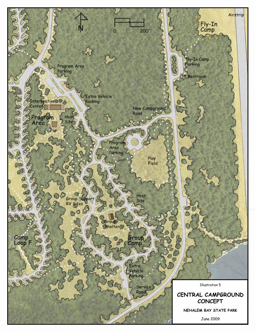
Illustration 5
CENTRAL CAMPGROUNDCONCEPT
NEHALEM BAY STATE PARK
June 2009
0 200�N
Program AreaParking
Extra VehicleParking
Restroom
ProgramAreaParking
PlayField
HostSite
Group SupportRV Sites
GroupShelter
ExtraVehicleParking
ServiceRoad
Airstrip
Fly-In CampParking
HostSite
InterpretiveCenter New Campground
RoadProgramArea
GroupCamp
Fly-InCamp
CampLoop F

84 Nehalem Bay State Park
TITLE

OCTOBER 2009 MASTER PLAN 85
GOALS AND STRATEGIESXI. RESOURCE MANAGEMENT
XI. NATURAL, CULTURAL & SCENIC RESOURCE MANAGEMENTThis chapter outlines general guidelines for management, enhancement and restoration of natural, cultural and scenic resources in the park, based on OPRD polices and statewide objectives, and on specifi c issues identifi ed in the master planning process.
OPRD Natural Resource PolicyAs stewards of the natural resources entrusted to the Oregon Parks and Recreation Commission, it shall be the policy of Oregon Parks and Recreation Department to:
Proactively manage the natural resource base 1.for its contribution to the regional landscape, as well as, its function within a site specifi c planned landscape.Actively cooperate and communicate with 2.our public and private neighbors to promote compatible programs and practices.Inform, involve and educate the public in 3.signifi cant planned management actions, including the scientifi c and practical aspects of current management techniques and strategies.Consider the signifi cant ecological, 4.recreational and aesthetic qualities of our resources to be the highest priority.Develop and follow management programs 5.and action plans which exemplify excellence in resource stewardship, fulfi ll the agency mission, are guided by the management intent of our property classifi cation system and meet or exceed federal, state and local laws and regulations.
Statewide Natural Resource Management ObjectivesOPRD’s natural resource management guidelines for state parks are based on system-wide objectives, on the mapping of natural resource conditions in the park, and on ecosystem patterns.A summary of the natural resource conditions in the planning area is included in the Heritage Assessment chapter. Detailed resource maps for the park are available for viewing at the OPRD Salem headquarters offi ce and the Nehalem Bay State Park offi ce in Manzanita.
The following objectives have been established by OPRD to guide natural resource management decisions for OPRD’s properties statewide. These statewide objectives were considered in combination with the particular resource conditions at Nehalem Bay State Park to determine specifi c objectives for the park. The park-specifi c objectives are discussed later in this chapter. The statewide objectives are listed below:
Protect all existing high value, healthy, native 1.Oregon ecosystems found within OPRD-managed properties. (Based on Oregon Natural Heritage ecosystem types and OPRD defi nition of high quality.)
Allow successional processes to proceed a.without intervention except as may be needed in particular circumstances.Identify and monitor existing high b.quality ecosystems for the presence of threats to desired ecosystem types or conditions. Determine whether there are changes desired in ecosystem types or conditions based on consultation with Oregon Department of Fish and Wildlife, the Oregon Natural Heritage Information Center, the Oregon Department of Agriculture Protected Plants section, natural resource interest groups and any affected federal resource management agencies.

86 Nehalem Bay State Park
TITLE
Manage the resources to eliminate any c.unacceptable threats or to attain desired ecosystem conditions and types.Following a natural or human-caused d.catastrophic event, such as a major fi re, wind throw, landslide or fl ooding; determine what management actions are needed, if any, to attain a desired ecosystem condition or type.
Where appropriate, restore or enhance existing 2.low quality resource areas to a higher quality or desired ecosystem types or conditions based on consultation with natural resource agencies as to what a desired ecosystem should be for the planning area and for the region. Identify areas of low resource signifi cance to consider for future recreational use and development, as identifi ed in the park master plan. Manage all OPRD properties to protect 3.existing occurrences of state or federally listed or candidate species to the approval of jurisdictional agencies:
Integrate species management plans a.into ecosystem management plans that include the monitoring and management of indicator species.For selected lands, in consultation with b.natural resource regulatory agencies, determine how best to manage for protected species recovery and related desired ecosystem types and conditions.
Manage all OPRD lands and uses to minimize 4.erosion, sedimentation, and other impacts on important resources.Identify and acquire additional lands from 5.willing landowners, or enter into management partnerships with landowners, to provide long term viability for important natural resources within OPRD-managed properties, as needed. Consider connectivity of resources across properties.In areas of high quality ecosystems or habitats, 6.endeavor to provide opportunities for the
public to experience the following:Sights, sounds, smells and feeling of a.ecosystems representative of Oregon and the region;Understanding of the ecosystem structure, b.composition and function;Larger views of the landscape of which the c.ecosystem is a part.
In selected areas of low quality natural 7.resources, manage for:
Popular or attractive native plants or a.animals that are appropriate to the local ecosystem;Desired views or settings;b.Desired cultural landscape restorations for c.interpretation.
Locate, design and construct facilities 8.that provide public access to high quality ecosystems or habitats in a manner that avoids signifi cant impacts on the ecosystems. For those OPRD properties or sites which are 9.historically signifi cant and which have been identifi ed by the Department as priority sites for emphasizing cultural resource protection, management and interpretation, manage the natural resources in the cultural resource areas to support cultural resource interpretation, unless this would result in unacceptable confl icts with protected species or areas of special natural resource concern.Manage OPRD natural resources to protect 10.visitors, staff, facilities and neighboring properties from harm.Manage OPRD natural resources to protect 11. them from threats from adjacent or nearby properties or their use.Limit the use of non-native plants to developed 12.facility areas or intensive use areas, and as is needed to withstand intensive use and to provide desired amenities such as shade, wind breaks, etc. Wherever possible, use native species in landscaping developed sites.

OCTOBER 2009 MASTER PLAN 87
GOALS AND STRATEGIESXI. RESOURCE MANAGEMENT
Professionally accepted protocols for ��addressing known and potential at-risk species occurrences will be followed.
At-Risk SpeciesBald eagle: A pair of bald eagles (Haliaeetusleucocephalus) nests along the bay shore. This species was previously listed as “threatened” under federal (U.S. Fish and Wildlife Service) and state (Oregon Department of Fish and Wildlife) Endangered Species Acts (ESA). It was recently removed from the federal list, and the state is currently in the process of delisting this species. Currently, any activities within a half mile of the nest must follow protocols prescribed by ODFW under the state ESA.
Pink sand-verbena: A single pink sandverbena plant (Abronia umbellata ssp. Brevifl ora) was found at Nehalem Bay, located on the sandy beach. It is a federal (U.S. Fish and Wildlife Service) species of concern; and a state (Oregon Department of Agriculture) endangered species; and is on the Oregon Natural Heritage Information Center’s Heritage List 1 (“threatened or endangered throughout range”). This plant is vulnerable to disturbance of any kind, and is a high priority for management. To protect and manage this site, control of competing vegetation such as European beachgrass and searocket is recommended. It is also recommended to place pink sandverbena seeds obtained from Oregon seed banks in the area during winter to establish new plants and increase the local population size.Luckily, the location of this plant on the leeward side of a foredune is relatively unpopular to most tourists, although horseback riders do pass near the location. Fencing should be installed to protect the area from recreational use. A “Conservation Strategy for Pink Sand-verbena” has been developed by the Institute for Applied Ecology, US Forest Service, Bureau of Land management and OPRD. Management of the site must be consistent with the Strategy. This plant is usually an annual,
Forest Management ObjectivesForest associations that occur in the park are illustrated by the background maps titled “Plant Communities and Conditions.” Detailed descriptions of each plant association are provided in the background report that accompanies these maps, titled “Vegetation Inventory and Mapping, Nehalem Bay State Park and Cougar Valley Ranch Complex.”
Forested areas in both parks will require appropriate levels of on-going management to ensure that growth progresses toward healthy, mature, native forest types. The OPRD forester will prescribe management actions for long term forest management. The management actions will address the following objectives:
Maintain a healthy native forest structure and ��species composition over time.Specifi c sites within forests where views are ��desirable will require management to maintain screened views through mature forest over time.Developed recreation areas will require ��management to retain grassy open space with shade trees where desired and screening vegetation where needed. Hazard tree management will be needed to protect park visitors and facilities.Any thinning operations in the park will be ��planned to keep to a minimum the threat of windthrow. Forest management will be planned to ��accomplish effective forest fi re fuel control as needed.The forest will be managed to retain an ��appropriate level of woody debris and snags for habitat. Management of invasive weeds will be ��especially important for the success of planted forests, at the edges and openings of established forests and in sparsely treed forest communities.

88 Nehalem Bay State Park
TITLE
and its location and distribution can change from year to year. All suitable habitat should be treated cautiously, with surveys prior to any ground disturbance. Suitable habitat is found on dry sand beach and active dunes above mean high tide.
Yellow sand-verbena and large-headed sedge: Yellow sandverbena (Abronia latifolia) and largehead sedge (Carex macrocephala) were also found at Nehalem Bay. Neither are federally or state-listed, but both are Oregon Natural Heritage Information Center’s Heritage List 4 (“watch”). They are found in numerous locations, concentrated on the beach at the south end of the spit. Competing vegetation such as European beachgrass should be removed from around plants and controlled to prevent re-encroachment. This should be a management priority, in conjunction with snowy plover habitat restoration in this area.
Invasive Weeds of ConcernInvasive non-native plants pose one of the most immediate threats to natural resource conditions at the parks. Control of invasive plants will be of paramount importance in prioritizing and implementing projects for habitat management.
The three invasive non-native plants of concern discussed below – Himalayan blackberry, English ivy and Japanese knotweed - were mapped at numerous sites in both parks during the fi eld inventories of plant communities. These and other weeds that occur in the parks are discussed in the “Management Strategies” sections of this chapter.
Himalayan blackberry occurs in a wide variety ��of population sizes throughout the park. It is generally regarded as impractical, or even impossible to eradicate on a large scale. Areas adjacent to the park also have and abundance of blackberry, which will continually provide a seed source.
English ivy, while not as abundant as ��Himalayan blackberry, has spread over large areas in some locations, particularly in the shore pine-Sitka spruce/evergreen huckleberry plant association.Japanese knotweed, the least extensive of ��the three mapped exotics, occurs in the park in small groups or as individual plants along Nehalem Bay in sparsely vegetated areas.Reportedly it also occurs at the airport and in Camp Loop A. It is also found on other lands upriver, which suggests a continual seed source.
Invasive Weed Treatment Methods
OPRD is currently developing a program and policy for identifying and documenting weed infestations with the goal of prioritizing treatment and taking steps towards controlling further spread and restoring problem areas where feasible through Integrated Pest Management (IPM).
Himalayan blackberry: Methods for removing or managing Himalayan blackberry vary depending on the type of environment, for example, forest versus meadow. Regardless of the method, it is not recommended to clear areas that won’t be maintained. Repeated mowing will eventually kill the plant, although this can take some time. The ground can be covered with a thick, dark material to prevent new sprouts from coming up. Digging up the root crowns and side roots is effective but very slow and labor-intensive. Goats can be an excellent option for managing Himalayan blackberry in open areas. Whichever methods are used will be based on guidance provided in the IPM.
English ivy: English ivy requires manual removal. As with other invasive plants, the sites must be maintained to prevent recurrence.Removing ivy from trees is a high priority, as the plant fl owers and fruits predominantly on vertical vines. The vines should be cut at shoulder height

OCTOBER 2009 MASTER PLAN 89
GOALS AND STRATEGIESXI. RESOURCE MANAGEMENT
and also slightly above ground level. At least a 6 foot area around the tree should be cleared of vines and roots. Ivy should not be left on the ground and should be desiccated to prevent resprouting.Known locations should be visited once a year to remove resprouts. The IPM will be used as guidance in determining appropriate methods.
Japanese knotweed: Japanese knotweed can be diffi cult to eradicate once it is established, so monitoring and maintaining known sites is critical. Small clumps should be carefully dug up, removing the entire rhizome. With large clumps this would be very labor intensive and diffi cult to fully accomplish, so it is better to repeatedly cut the stems near the ground and apply a systemic herbicide to the spot. Without herbicide, several cuttings would be required over several years to ensure that shoots don’t resprout. Access for eradication may be diffi cult where they often grow on very steep river banks. There are numerous seed sources on other public and private lands, and eradication efforts should be directed to these infested areas as well. Appropriate methods will be determined based on the guidance provided in the IPM.
Tillamook County DMD SitesPark property located on the spit south of the horse concession has been identifi ed by Tillamook County as possible future sites for disposal of dredged materials. Three such “DMD” sites have been adopted by the County as part of their Comprehensive Plan. These sites are shown on the “Habitat Concepts” maps that follow in this chapter.
Under Comprehensive Plan Policy 7.1(10), the County is required to coordinate with OPRD regarding any future use of the DMD sites in the park in order to assure consistency with the park Master Plan, and to address any issues concerning signifi cant habitats and other natural resources.
Desired Future Habitat TypesThe maps that follow this section, titled “Habitat Management Concepts,” illustrate OPRD’s conceptual proposals for establishing a diverse native ecosystem pattern in the park over time. The concepts are based on the background mapping and report on plant community types and conditions and historic ecosystem patterns, and the recommendations of OPRD’s natural resource staff and consultants. In addition, the proposals refl ect the recreational, scenic and cultural landscape objectives for the park that have been determined to be compatible with natural resource management objectives. The concepts are intended to be adaptable, to respond to new and better information that may emerge prior to, or as a result of experience with project implementation. Desired future habitat types for Nehalem Bay State Park are illustrated as the following:
Forested Wetlands��Scrub-Shrub Wetlands��Emergent Wetlands��Mixed Coniferous Forests��Shore Pine Forests��American Dunegrass��Open Sand / Sparse Dunal Vegetation��

90 Nehalem Bay State Park
TITLE

NNEE
HHAA
LLEE
MM
BBAA
YY
N-12N-12
N-#N-#
Note: This product was produced for conceptual Note: This product was produced for conceptual planning purposes. It was not prepared for, and mayplanning purposes. It was not prepared for, and maynot be suitable for, legal, engineering or surveying not be suitable for, legal, engineering or surveying purposes. Users of this information should reviewpurposes. Users of this information should reviewthe primary data sources to ascertain the usabilitythe primary data sources to ascertain the usabilityof the information.of the information.
Habitat Concepts
Nehalem Bay State ParkNorth Half
September 2009
Approximate Park BoundaryApproximate Park BoundaryCounty - adopted DMD SitesCounty - adopted DMD Sites(wetlands & 50' shoreland setback excluded)(wetlands & 50' shoreland setback excluded)
Desired Future Habitat TypesDesired Future Habitat TypesForested WetlandForested WetlandScrub-Shrub WetlandScrub-Shrub WetlandEmergent WetlandEmergent WetlandMixed Coniferous ForestMixed Coniferous ForestShore Pine ForestShore Pine ForestAmerican DunegrassAmerican DunegrassOpen Sand / Sparse VegetationOpen Sand / Sparse VegetationFacility Development AreaFacility Development Area
00 600600 1,2001,200300300FeetFeet¨


NN EE HH AA LL EE MM BB AA YY
N-12N-12
N-14N-14
N-13N-13
N-#N-#
Approximate Park BoundaryApproximate Park BoundaryCounty - adopted DMD SitesCounty - adopted DMD Sites(wetlands & 50' shoreland setback excluded)(wetlands & 50' shoreland setback excluded)
Desired Future Habitat TypesDesired Future Habitat TypesForested WetlandForested WetlandScrub-Shrub WetlandScrub-Shrub WetlandEmergent WetlandEmergent WetlandMixed Coniferous ForestMixed Coniferous ForestShore Pine ForestShore Pine ForestAmerican DunegrassAmerican DunegrassOpen Sand / Sparse VegetationOpen Sand / Sparse VegetationFacility Development AreaFacility Development Area
Note: This product was produced for conceptual Note: This product was produced for conceptual planning purposes. It was not prepared for, and mayplanning purposes. It was not prepared for, and maynot be suitable for, legal, engineering or surveying not be suitable for, legal, engineering or surveying purposes. Users of this information should reviewpurposes. Users of this information should reviewthe primary data sources to ascertain the usabilitythe primary data sources to ascertain the usabilityof the information.of the information.
Habitat Concepts
Nehalem Bay State ParkSouth Half
September 2009
00 600600 1,2001,200300300FeetFeet¨


OC
TO
BE
R 2
00
9 M
AS
TE
R P
LA
N9
5
GO
AL
S A
ND
ST
RA
TE
GIE
SX
I. RE
SO
UR
CE
MA
NA
GE
ME
NT
NATURAL RESOURCE MANAGEMENT STRATEGIESFEATURE / CONDITION DESIRED FUTURE HABITAT MANAGEMENT STRATEGIESSnowy Plover Management Area:The narrow spit located south of the southern beach access parking and horse rental concession is regarded as a management area within which new development will be restricted in order to avoid confl icts with snowy plover recovery efforts under the “Habitat Conservation Plan (HCP) for the Western Snowy Plover.” All recreational and resource management activities within this area must comply with snowy plover site management plans completed under the parameters of the HCP. A much smaller area of the spit will eventually be identifi ed and managed for restoration of snowy plover nesting habitat. This is likely to occur at the far end of the spit.
Recommended future habitat types are represented on the “Habitat Management Concepts” map for the spit. These concepts will be subordinate to any restoration and management strategies subsequently prescribed under the HCP.
Management actions must be consistent with management prescriptions specifi ed in the HCP. Habitat restoration projects will be consistent with local policies, zoning and permitting requirements.
Bald Eagle Nest:An active bald eagle nest is located along the bay shore, and the territory of the nesting pair includes a large area of the park. (Refer to the background maps titled “At-Risk Species.”) Park development is proposed within a distance from the nest where regulations apply pursuant to the Endangered Species Act (ESA), including the cabin village, staff residences and non-motorized trail development. Some forest management activities may also be needed within this area. Activities within the regulated area must comply with protocols prescribed by ODFW.
High quality native conifer forests within the regulated area will be preserved. As discussed below, where shore pine and maritime pine forests of low habitat quality fall within the regulated area, conversion to mixed native conifer forest is recommended.
Consult with ODFW and comply with related protocols.

96
Nehale
m B
ay S
tate
Pa
rk
TIT
LE
Pink Sand-verbena: A single pink sand-verbena plant has been located along the leeward side of the foredune. As discussed below, potential habitat for this species occurs along the foredune for the length of the park and at several open sand habitats in the park’s interior.The identifi ed plant is remote in relation to existing and proposed recreational development, and also falls within the snowy plover management area. A “Conservation Strategy for Pink Sand-verbena” has been developed by the Institute for Applied Ecology, US Forest Service, Bureau of Land management and OPRD. Management of the site must be consistent with the Strategy.
Manage as open sand / sparse dunal vegetation habitat.
Comply with requirements of the snowy plover HCP and Pink Sand-verbena Conservation Strategy.Manage this site, and any other sites found in the future, as an open sand / sparse dunal vegetation habitat. Remove European beachgrass from an area around the plant using hand tools. Monitor and remove beachgrass resprouts. Fence the site.Consider obtaining pink sand verbena seeds and placing them during winter to establish new plants in areas that provide suitable open sand habitat.
Yellow Sand-verbena and Large-Headed Sedge: Populations of yellow sand-verbena and large-headed sedge were identifi ed at the end of the spit. European beachgrass has encroached on these communities.These sites are within the snowy plover management area.
Manage as open sand / sparse dunal vegetation habitat.
The affected area is in the likely focus area for snowy plover habitat restoration. HCP site management plans, including restoration plans, will be consistent with state and federal laws regarding sensitive plant species.Removal of beachgrass and scotchbroom from this area is recommended in conjunction with management of yellow sand-verbena and large-headed sedge populations. This may be accomplished by volunteer work crews using hand tools. Yellow sand-verbena may tolerate bulldozing.

OC
TO
BE
R 2
00
9 M
AS
TE
R P
LA
N9
7
GO
AL
S A
ND
ST
RA
TE
GIE
SX
I. RE
SO
UR
CE
MA
NA
GE
ME
NT
Forested Wetlands:Forested wetlands occur over much of the park. The largest and most obvious are refl ected on the background resource maps. Some wetlands have not been mapped due to their relatively small size or hidden locations.With few exceptions planned development projects are sited to avoid wetlands. Some road and trail crossings will be needed. Wetland delineations may be needed in certain areas where encroachment may potentially occur.Some wetlands along the bay shore provide suitable habitat for Bog Anenome, although none have been identifi ed. (Refer to the background maps titled “At-risk Species.”) In camp loop C, the only patch of reed canary grass found in the park’s interior occurs among native wetland tree, shrub and herbaceous species.
Manage as forested wetlands. Comply with applicable state and federal permitting requirements where encroachment is necessary, and where resource management activities trigger such requirements.Monitor for weeds and remove weeds where feasible, especially in highest quality wetlands and where Bog Anenome may occur.If feasible, remove the reed canarygrass from the forested wetland in camp loop C using methods specifi ed in IPM. Solarization may be feasible where the canopy is very open.
Scrub-Shrub Wetlands:Scrub-shrub wetlands occur in the northern part of the park and over a large area on the spit.
Manage as scrub-shrub wetlands. Monitor for weeds and remove weeds where feasible, especially in highest quality wetlands. Small infestations may be treated with manual or mechanical controls or other methods specifi ed in IPM.Management activities must be consistent with HCP restoration and management plans within the snowy plover management area.

98
Nehale
m B
ay S
tate
Pa
rk
TIT
LE
Emergent Wetlands:Emergent wetlands occur along the bay shore and on the spit. Some wetlands along the bay shore provide suitable habitat for Point Reyes Bird-Beak although none have been identifi ed. (Refer to the background maps titled “At-risk Species.”)A unique native grassland association of tufted hairgrass and Pacifi c silverweed occurs along the bay shore. (Refer to the “Plant Communities and Conditions” maps.) This community is threatened by several exotic species.
Manage as emergent wetlands. Monitor for weeds and remove weeds where feasible, especially highest quality wetlands and where Point Reyes bird-beak may occur. Remove Japanese knotweed, reed canarygrass, colonial bentgrass and quackgrass from the association of tufted hairgrass and Pacifi c silverweed along the bay shore. Small infestations may be treated with manual or mechanical controls or other methods specifi ed in IPM.Management activities must comply with HCP restoration and management plans within the snowy plover management area.
Riparian AreasRiparian areas along the bay shore and around numerous wetlands have not been separated out from their adjacent aquatic and upland habitats in the resource mapping.Trail development is planned along riparian areas, and roads and trails will cross these features at certain locations.
Manage as riparian habitats. Locate and design roads, trails and other projects to minimize impacts on riparian communities.Manage using professionally accepted practices. Removal of mature native trees, snags, and shrubs from viable riparian habitats will occur only as prescribed for purposes related to visitor safety or forest health. Snags and fallen trees will be left in place to benefi t riparian and aquatic habitat, except as needed to remove obstructions or address safety concerns. Views from trails or other recreation use areas, as seen through riparian forests, may be maintained through careful pruning to remove lower tree limbs and maintain the height of understory shrubs.

OC
TO
BE
R 2
00
9 M
AS
TE
R P
LA
N9
9
GO
AL
S A
ND
ST
RA
TE
GIE
SX
I. RE
SO
UR
CE
MA
NA
GE
ME
NT
Mixed Native Coniferous ForestsHigh quality associations of sitka spruce, western hemlock, Douglas fi r and shore pine, located mostly along the bay shore and in the northern part of the park, have signifi cant conservation value. Some of the sitka spruce are reportedly as old as 200 years. (Refer to the background maps titled “Plant Communities and Conditions.”)
Manage for succession to old growth coniferous forests.
Management for forest health and visitor safety may be necessary in certain areas.
High Quality Shore Pine Forests:Some of the shore pine associations in the northern part of the park have diverse native understory and are of conservation value in their current condition. (Refer to the background maps titled “Plant Communities and Conditions.”)
Manage as shore pine forests. Management for forest health and visitor safety may be necessary in certain areas.Because shore pine is not a climax community and does not continue to regenerate over the long term, planting of shore pine may be needed to sustain this habitat type. Understory treatment may be necessary as well.
Shore Pine and Maritime Pine ForestsThese two pine species are mixed in some stands, but both occur essentially as monocultures over large areas. Shore pine is native to the Oregon Coast. Maritime pine is not. Both were introduced as part of the dune stabilization program during the 1950’s. Most of these forests have relatively low diversity in the understory dominated by European beachgrass and /or scotch broom. (Refer to the background maps titled “Plant Communities and Conditions.”)
Replacement of maritime pine and some shore pine with a mix of native conifer species would be desirable to achieve more diverse and native habitat types. Species such as sitka spruce, Douglas fi r and western hemlock are also longer lived, and would be more affective in shading out scotch broom and European beachgrass. While this kind of habitat change would be a major undertaking on a large scale, target areas should be considered where the ecological benefi ts are likely to be most signifi cant and where such projects are most likely to be successful.Shore pine forests should be retained where they best fi t the setting, such as directly behind the foredune. Because the shore pine has a low profi le in comparison to other native conifers, this forest type should also be retained along the airstrip.
Where change in habitat type is proposed, underplant pines with mixed native conifers, and remove maritime pine once planted species become established, or let maritime pine die out, as it is not regenerating. Because shore pine is not a climax community and does not continue to regenerate over the long term, planting of shore pine may be needed to sustain this habitat type.Comply with ESA protocols within regulated eagle territory.Management actions must be consistent with HCP habitat restoration and management plans within the snowy plover management area.

10
0N
ehale
m B
ay S
tate
Pa
rk
TIT
LE
American Dunegrass:American dunegrass is dominant on the leeward side of the foredune. This native dunegrass has become increasingly scarce since the introduction of the non-native European beachgrass, which has outcompeted the native dunegrass along most of the coastline. Along the northern reach of the foredune in the park, the native dunegrass is in marginal condition due to European beachgrass encroachment. The native dunegrass is in good condition along most of the southern reach of the foredune on the spit. Scotch broom and European beachgrass have degraded the native dunegrass community to a marginal condition at the far end of the spit.
Manage as American dunegrass community. Prevent further encroachment of European beachgrass and scotchbroom in the higher quality American dunegrass community along the spit. Hand tools may be used, although this approach may not be feasible over large areas. Consider any applicable methods specifi ed in IPM. Some herbicide formulations and concentrations will kill European beachgrass without harming American dunegrass, which would allow broadcast applications in areas where the two are very intermixed.All management and restoration activities must be consistent with site management plans completed under the parameters of the HCP.
Open Sand Habitats: Dunal habitats of open sand and sparse vegetation occur at several sites in the park’s interior north and east of the airstrip, and along the windward side of the foredune where it transitions to the beach. European beachgrass is interspersed with the open sand along the foredune and at most of the interior sites. At the far end of the spit, scotch broom and European beachgrass are reducing the open sand over a large area. The interior sites are remnants of the open dune landscape that once characterized most of the park. The largest interior site has a salt rush community, and another has a remnant population of red fescue.The open sand areas provide suitable habitat for pink sand-verbena, many leaf gilia, yellow sand-verbena and large headed sedge. At the end of the spit open sand habitats are colonized by yellow sand-verbena and large headed sedge. (Refer to the background maps titled “At-Risk Species.”)
Manage as open sand / sparse native vegetation habitat types.
Where feasible, these habitats should be managed to control further encroachment of non-native species, preserve the remnant native species, and maintain the open sand character.Management of interior sites appears feasible due to their limited geographic extent. Removal of beachgrass and other non-natives could be accomplished by volunteer work parties using hand tools, removing all above ground shoots and shallow rhizomes. Monthly monitoring would be needed to remove resprouts, particularly in the summer.At the end of the spit in the proposed HCP habitat restoration focus area, removal of European beachgrass and scotch broom using heavy equipment may be considered, except areas that support large-headed sedge may need to be worked by hand. Yellow sand-verbena may tolerate bulldozing.All management and restoration activities on the spit must be consistent with site management plans completed under the parameters of the HCP.
OCTOBER 2009 MASTER PLAN 101
GOALS AND STRATEGIESXI. RESOURCE MANAGEMENT
Scenic Resource ManagementThere is no formal policy on scenic resource management in state parks except for general guidance provided by OPRD’s mission statement and OPRD’s recreation setting defi nitions developed for the Statewide Comprehensive Outdoor Recreation Plan. The recreation setting defi nitions are applied in the master plan assessments. The department has a long history of exploring opportunities to acquire or establish agreements regarding the management of properties for scenic enjoyment, and continues that tradition in its management actions.
Ocean Views
Ocean views from the park are generally seen only where trails cross the foredune, and from the beach. OPRD should explore the possibility of providing an accessible ocean view for physically challenged park visitors, although this may not be feasible because of the foredune height and its steep topography. Maintaining the foredune height and stabilizing vegetation is critical to help guard against ocean fl ooding in storm surge and tsunami events. In addition, the City of Manzanita has recently developed an accessible beach access.
Nehalem Bay Views
Currently Nehalem Bay is seen from the main park road where it approaches the bay, from the trail around the end of the air strip, and from points along the spit trail. A trail is planned for the eastern area of the park that will follow the older dune ridges that overlook the bay. Opportunities to provide bay views along this trail will be explored. Views of the bay may also
be possible from the proposed cabin village in the northeast part of the park. Maintaining views will require vegetation management at key viewpoints with occasional pruning of the lower limbs of trees and maintaining the height of understory vegetation.
Cultural Resource ManagementSites where archeological resources are most likely to be found were identifi ed in the master planning process through a review of State Historic Preservation Offi ce (SHPO) fi les on previous archeological investigations. Several such sites are present at Nehalem Bay State Park.
SHPO staff determined that further investigations could be deferred to the construction design phase for planned projects. OPRD will be required to consult with SHPO prior to ground breaking for construction projects and other ground disturbing activities, and follow required SHPO protocol for investigating project sites and protecting any signifi cant resources.
Prior to beginning planned new development projects described in the master plan, OPRD or SHPO staff will arrange consultation with representatives of Native American Tribes that claim cultural affi liation to the area to involve the Tribes in assessing the cultural signifi cance of the project sites and actions needed to protect any signifi cant resources.

102 Nehalem Bay State Park
TITLE

OCTOBER 2009 MASTER PLAN 103
GOALS AND STRATEGIESXII . LAND USE REQUIREMENTS
XII. SUMMARY OF LAND USE APPROVAL REQUIREMENTSDevelopment of the park uses and facilities described in this master plan is governed by Tillamook County under he provisions of the County’s comprehensive plan. The County’s comprehensive plan is acknowledged by the Land Conservation and Development Commission (LCDC) pursuant to the statewide land use goals, statutes and related administrative rules.
This master plan has been formulated through the master planning process described under OAR 736 Division 18 and OAR 660 Division 34. The master planning process includes procedures for coordinating with affected local governments to assure that the park master plan is compatible with the local government comprehensive plan.
Land Use Approval of the Master PlanLand use approval of the state park master plan by the affected local government is required unless all of the planned state park projects are determined by the local government to be compatible with the local comprehensive plan and related zoning ordinance provisions. “Compatible” means that development permits may be approved for all of the planned park projects without fi rst amending the local government’s comprehensive plan or zoning ordinance.
Development Permits for State Park ProjectsDevelopment permits will be required for most of the development projects described in the master plan. Prior to beginning construction of any project, the project manager is responsible for consulting with the affected local government planning department and obtaining the necessary development permits. The specifi c requirements for obtaining development permits for a project, and the kind of local permitting process required, may vary from one project to another. The time required for completing the development permitting process may also vary, therefore, the project manager should consult with the local government planning department early enough to assure that the permitting process is completed prior to the target date for beginning construction. Prior to issuance of development permits for a project, the local government will review the project plans and specifi cations to assure that the project proposed for construction is consistent with the design concept and description of the project in the park master plan and with any applicable development standards in the local government’s ordinances.
Variations from the Master PlanUnder the provisions of OAR 736-018-0040, OPRD may pursue development permits for a state park project that varies from a state park master plan without fi rst amending the master plan provided that the variation is minor, unless the master plan language specifi cally precludes such variation. Any specifi c project design elements that cannot be changed by applying the “Minor Variation” rule are indicated in the design standards for the projects in the master plan.

104 Nehalem Bay State Park
TITLE
The OPRD Director must determine that a proposed variation from the master plan is “minor” using the criteria in OAR 736-018-0040. A minor variation from the master plan, which is approved by the Director, is considered to be consistent with the master plan, contingent upon the concurrence of the affected local government.
Rehabilitation of Existing State Park UsesState laws allow OPRD to continue any state park use or facility that existed on July 25, 1997. (See ORS 195.125 and OAR 660-034-0030(8).) The laws allow the repair and renovation of facilities, the replacement of facilities including minor location changes, and the minor expansion of uses and facilities. Rehabilitation projects are allowed whether or not they are described in a state park master plan. These projects are subject to any clear and objective siting standards required by the affected local government, provided that such standards do not preclude the projects.
Prior to applying for development permits for a project involving a minor location change of an existing facility or minor expansion of an existing use or facility, the OPRD Director must determine that the location change or expansion is “minor” using the criteria in OAR 736-018-0043. A determination by the Director that a proposed location change or expansion is minor is contingent upon the concurrence of the affected local government.

OCTOBER 2009 MASTER PLAN 105
GOALS AND STRATEGIESAPPENDIX A
APPENDIX A HABITAT TYPES AND CLOSELY ASSOCIATED WILDLIFESource: O’Neil, Thomas A., David H. Johnson, Charley Barrett, Marla Trevithick, Kelly A. Bettinger, Chris Kiilsgaard, Madeleine Vander Heyden, Eva L. Greda, Derek Stinson, Bruce G. Marcot, Patrick J. Doran, Susan Tank, and Laurie Wunder. Matrixes for Wildlife-Habitat Relationship in Oregon and Washington.Northwest Habitat Institute. 2001. In D. H. Johnson and T. A. O’Neil (Managing Directors)Wildlife-Habitat Relationships in Oregon andWashington. Oregon State University Press, Corvallis, Oregon, USA. 2001.
Relevance to the Nehalem Bay State Park Setting: Species lists derived from the above source were reviewed by OPRD’s Wildlife Biologist, and edited according to their relevance to the Nehalem Bay State Park setting.
Habitat Type: Westside Lowland Conifer – Hardwood Forest
Closely Associated Mammals: Pacifi c Shrew; Trowbridge’s Shrew; Shrew-Mole; Coast Mole; California Myotis; Long-legged Myotis; Silver-haired Bat; Big Brown Bat; Mountain Beaver; Townsend’s Chipmunk; Douglas’ Squirrel; Northern Flying Squirrel; Western Pocket Gopher; Deer Mouse; Bushy-tailed Woodrat; Western Red-backed Vole; White-footed Vole; Red Tree Vole; Common Porcupine; Gray Fox; Fisher.
Closely Associated Birds: Hooded Merganser; Common Merganser; Ruffed Grouse; Blue Grouse; Marbled Murrelet; Band-tailed Pigeon; Northern Pigmy-owl; Barred Owl; Northern Saw-whet Owl; Anna’s Hummingbird; Allen’s Hummingbird; Olive-sided Flycatcher; Pacifi c-slope Flycatcher; Warbling Vireo; Winter Wren; Golden-crowned Kinglet; Varied Thrush; Black-throated Gray Warbler; Hermit Warbler; Wilson’s Warbler; Western Tanager; Pileated Woodpecker.
Closely Associated Reptiles: None.
Closely Associated Amphibians: Ensatina; Red-legged Frog.
Habitat Type: Coastal Dunes and Beaches
Closely Associated Mammals: Raccoon.
Closely Associated Birds: Black-bellied Plover; Western Snowy Plover; Semipalmated Plover; Wandering Tattler; Whimbrel; Ruddy Turnstone; Black Turnstone; Sanderling; Western Sandpiper; Dunlin; Herring Gull; Western Gull; Glaucous-winged Gull; Glaucous Gull; Caspian Tern; American Crow.
Closely Associated Reptiles: CommonGartersnake.
Closely Associated Amphibians: None.
Habitat Type: Westside Riparian - Wetlands
Closely Associated Mammals: Fog Shrew; Pacifi c Shrew; Pacifi c Water Shrew; Mountain Beaver; American Beaver; Deer Mouse; Dusky-footed Woodrat; White-footed Vole; Long-tailed Vole; Muskrat; Pacifi c Jumping Mouse; Nutria; Raccoon; Fisher; Mink; Northern River Otter.

106 Nehalem Bay State Park
TITLE
Buffl ehead; Ruddy Duck; American Coot; Greater Yellowlegs; Lesser Yellowlegs; Willet; Western Sandpiper; Least Sandpiper; Dunlin; Long-billed Dowitcher; Caspian Tern; Short-eared Owl; Tree Swallow; Northern Rough-winged Swallow; Barn Swallow; Marsh Wren; Common Yellowthroat; Lincoln’s Sparrow; Swamp Sparrow; Red-winged Blackbird.Closely Associated Reptiles: Common Garter Snake.
Closely Associated Amphibians: NorthwesternSalamander; Long-toed Salamander; Rough-skinned Newt; Western Toad; Pacifi c Chorus Tree frog; Red-legged Frog; Bullfrog.
Habitat Type: Open Water – Lakes, Rivers and Streams
Closely Associated Mammals: Western Small-footed Myotis; Western Pipistrelle; Townsend’s Big-eared Bat; Pallid Bat; American Beaver; Muskrat; Nutria; Mink; Northern River Otter.
Closely Associated Birds: Western Grebe; American White Pelican; Double-crested Cormorant; Great Blue Heron; Great Egret; Greater White-fronted Goose; Snow Goose; Ross’s Goose; Canada Goose; Trumpeter Swan; Wood Duck; Eurasian Wigeon; Northern Shoveler; Northern Pintail; Canvasback; Redhead; Greater Scaup; Lesser Scaup; Harlequin Duck; Buffl ehead; Common Goldeneye; Barrow’s Goldeneye; Hooded Merganser; Common Merganser; Ruddy Duck; Osprey; Bald Eagle; American Coot; Black-bellied Plover; Pacifi c Golden Plover; Semipalmated Plover; Greater Yellowlegs; Lesser Yellowlegs; Semipalmated Sandpiper; Western Sandpiper; Dunlin; Stilt Sandpiper; Wilson’s Phalarope; Mew Gull; Ring-billed Gull; California Gull; Herring Gull; Thayer’s Gull; Glaucous Gull; Caspian Tern; Vaux’s Swift; Belted Kingfi sher;
Closely Associated Birds: Great Blue Heron; Green Heron; Wood Duck; Mallard; Ring-necked Duck; Harlequin Duck; Hooded Merganser; Common Merganser; Ruffed Grouse; Spotted Sandpiper; Band-tailed Pigeon; Mourning Dove; Western Screech-owl; Belted Kingfi sher; Downy Woodpecker; Willow Flycatcher; Warbling Vireo; Red-eyed Vireo; Tree Swallow; Northern Rough-winged Swallow; Cliff Swallow; Barn Swallow; American Dipper; European Starling; Yellow Warbler; Black-throated Gray Warbler; Common Yellowthroat; Wilson’s Warbler; Yellow-breasted Chat; Lincoln’s Sparrow; Swamp Sparrow; Bullock’s Oriole; Purple Finch; Lesser Goldfi nch.
Closely Associated Reptiles: Common Garter Snake.
Closely Associated Amphibians: NorthwesternSalamander; Long-toed Salamander; Pacifi c Giant Salamander; Columbia Torrent Salamander; Southern Torrent Salamander; Rough-skinned Newt; Tailed Frog; Western Toad; Pacifi c Chorus Tree Frog; Red-legged Frog; Bullfrog.
Habitat Type: Herbaceous Wetlands
Closely Associated Mammals: Pallid Bat; American Beaver; Western Harvest Mouse; Deer Mouse; Townsend’s Vole; Long-tailed Vole; Muskrat; Nutria; Raccoon; Mink; Northern River Otter.
Closely Associated Birds: Common Loon; Pied-billed Grebe; Western Grebe; Clark’s Grebe; American Bittern; Great Blue Heron; Great Egret; Cattle Egret; Green Heron; Greater White-fronted Goose; Snow Goose; Ross’s Goose; Canada Goose; Trumpeter Swan; American Wigeon; Mallard; Blue-winged Teal; Cinnamon Teal; Northern Shoveler; Northern Pintail; Green-winged Teal; Canvasback; Redhead; Lesser Scaup,

OCTOBER 2009 MASTER PLAN 107
GOALS AND STRATEGIESAPPENDIX A
Purple Martin; Tree Swallow; Northern Rough-winged Swallow; Bank Swallow; Cliff Swallow; Barn Swallow; American Dipper.
Closely Associated Reptiles: None.Closely Associated Amphibians: Tiger Salamander; Northwestern Salamander; Long-toed Salamander; Rough-skinned Newt; Western Toad; Pacifi c Chorus Tree Frog; Red-legged Frog; Bullfrog.
Habitat Type: Bays and Estuaries
Closely Associated Marine Mammals: HarborSeal; Gray Whale.
Closely Associated Mammals: Raccoon; Mink; Northern River Otter.
Closely Associated Birds: Red-throatedLoon; Pacifi c Loon; Common Loon; Western Grebe; Clark’s Grebe; Brown Pelican; Brandt’s Cormorant; Double Crested Cormorant; Pelagic Cormorant; Great Blue Heron; Great Egret; Brant; American Wigeon; Northern Pintail; Canvasback; Greater Scaup; Surf Scoter; Black Scoter; Long-tailed Duck; Buffl ehead; American Coot; Black-bellied Plover; Semipalmated Plover; Greater Yellowlegs; Willet; Whimbrel; Long-billed Curlew; Ruddy Turnstone; Sanderling; Western Sandpiper; Least Sandpiper; Dunlin; Heermann’s Gull; Mew Gull; Ring-billed Gull; California Gull; Herring Gull; Thayer’s Gull; Western Gull; Glaucous-winged Gull; Glaucous Gull; Caspian Tern; Common Tern; American Crow; Purple Martin; Swamp Sparrow.
Closely Associated Reptiles: None.
Closely Associated Amphibians: None.
Habitat Type: Urban and Mixed Environs
Closely Associated Mammals: Virginia Opossum; Big Brown Bat; Brazilian Free-tailed Bat; Eastern Gray Squirrel, Eastern Fox Squirrel; Black Rat; Norway Rat; House Mouse; Raccoon.
Closely Associated Birds: Western Gull; Glaucous-winged Gull; Rock Dove; American Crow; European Starling; House Finch; House Sparrow.
Closely Associated Reptiles: None.
Closely Associated Amphibians: None.

108 Nehalem Bay State Park
TITLE