Embed Size (px)
Citation preview
Niko Kyyrönen 29.05.2019
Needfinding for a wind propelled autonomous surface vehicle
Thesis submitted for examination for the degree of Master of
Science in Technology
Espoo 29.05.2019
Thesis supervisor: Prof. Kalevi Ekman
Thesis advisor: MSc. Anna Friebe

Aalto University, P.O. BOX 11000, 00076 AALTO
www.aalto.fi
Abstract of master's thesis
Author Niko Kyyrönen
Title of thesis Needfinding for a wind propelled autonomous surface vehicle
Master programme Mechanical Engineering Code ENG25
Thesis supervisor Prof. Kalevi Ekman
Thesis advisor(s) MSc. Anna Friebe
Date 29.05.2019 Number of pages 2 + 82 Language English
Abstract
Autonomous surface vehicles (ASVs) are a type of unmanned vehicles that operate on the surface of the water and can be utilized for assorted tasks by equipping them with differ-ent technologies. Various energy sources can be used for the motion of vehicle as well. Wind propulsion is one of the available methods of harvesting energy for movement from the environment, which has potential to increase the persistence of the vehicle in addition to other advantages. Other unmanned technologies for the marine environment exist and the topic of what wind propelled ASVs might be best suited for was explored. ASVs have potential to improve oceanographic data gathering for marine research with vertical pro-filing capability in shallow oceans, where other technologies are inefficient or lacking. With station keeping abilities ASVs have potential to compete with bottom moored buoys with cost efficiency. Autonomous surface vehicles can also utilize wireless communication technologies in order to provide real time data or interact with other equipment. ASVs could be used for passive acoustic monitoring research for detecting underwater vocali-zations for the presence of animals in a given area with reduced costs. They could also be used to deploy and retrieve marine equipment and cut costs compared to current meth-ods. However, current legislation limits the use of ASVs.
Keywords Autonomous surface vehicle, ASV, Unmanned surface vehicle, USV, Marine
robot, Wind propulsion

Aalto-yliopisto, PL 11000, 00076 AALTO
www.aalto.fi
Diplomityön tiivistelmä
Tekijä Niko Kyyrönen
Työn nimi Käyttötarkoituksia purjehtivalle miehittämättömälle pinta-alukselle
Maisteriohjelma Mechanical Engineering Koodi ENG25
Työn valvoja Prof. Kalevi Ekman
Työn ohjaaja(t) MSc. Anna Friebe
Päivämäärä 29.05.2019 Sivumäärä 2 + 82 Kieli Englanti
Tiivistelmä
Miehittämättömät pinta-alukset (ASV) ovat veden päällä kulkevia robottiveneitä, joita voidaan käyttää moniin tarkoituksiin varustamalla ne eri teknologioilla. Liikkumiseen voidaan käyttää erilaisia energianlähteitä ja energiaa voidaan kerätä myös ympäristöstä. Yksi tapa on tuulen avulla purjehtiminen, jota käyttämällä voidaan pidentää ASVn toi-minta-aikaa. Purjehtiminen tarjoaa myös muita etuja. Meriympäristössä hyödynnetään myös muita miehittämättömiä teknologioita ja tuulivoimalla kulkevien miehittämättö-mien pinta-alusten etuja näihin verrattuna selvitettiin. ASVilla on potentiaalia parantaa merentutkimuksellisen datan keruuta mittaamalla vertikaaliprofiileilla matalissa me-rissä, joissa muut miehittämättömät teknologiat toimivat energiatehottomasti tai puut-teellisesti. Positiotaan pitävät ASVt saattavat myös pystyä kilpailemaan pohja-ankkuroi-tujen poijujen kanssa kustannustehokkaasti. Miehittämättömät pinta-alukset voivat hyö-dyntää erilaisia langattomia tiedonsiirtoteknologioita tuottamaan reaaliaikaista dataa tai vuorovaikuttamaan muiden laitteiden kanssa. Miehittämättömät pinta-alukset saattavat myös soveltua akustiseen tutkimuskäyttöön tutkimukseen merieläinten ääntelyiden ha-vainnointiin kustannustehokkaasti. Tämän lisäksi ASVt voisivat myös laukaista ja noutaa muuta laitteistoa meriympäristössä. Nykyinen lainsäädäntö kuitenkin rajoittaa miehittä-mättömien pinta-alusten käyttöä.
Avainsanat Miehittämätön pinta-alus, Autonominen pinta-alus

2
Foreword
As an avid fan of the marine environment I am really glad that I got to work for the ÅSR
project. In the beginning of my thesis work I spent one month in the Åland Isles where the
project is located and really enjoyed my time there. I want to thank the project manager
Anna Friebe for providing the opportunity to write a thesis for a concrete project and for
her support along the way. I also want to thank my supervisor Kalevi Ekman for his role
in facilitating teaching for product development at Aalto Design factory which I thor-
oughly enjoyed during my studies.
In Helsinki 29.5.2019
-Niko Kyyrönen

3
Table of contents
Abstract
Foreword
Table of contents ............................................................................................................... 3 Glossary ............................................................................................................................ 4 1 Introduction ............................................................................................................... 7
1.1 Background ........................................................................................................ 7 2 Design methodology ................................................................................................. 9 3 Design development ................................................................................................ 11
3.1 Benchmarking .................................................................................................. 11 3.1.1 Wind Propelled ASVs ............................................................................. 11 3.1.2 Other propulsion methods ....................................................................... 16 3.1.3 Other platforms for marine environmental measurements and sampling19
3.2 Further literature on other proposed use cases for ASVs ................................. 22 3.3 Learnings from benchmarking ......................................................................... 24 3.4 Opportunity Identification ................................................................................ 24
3.4.1 Innovation charter ................................................................................... 24 3.4.2 Mapping out the design space ................................................................. 25 3.4.3 Early exploration of the design space ..................................................... 26 3.4.4 Considerations on the suitability and performance of autonomous surface
vehicles ................................................................................................................. 29 3.4.5 Wind propulsion for autonomous surface vehicles ................................. 30 3.4.6 Considering trends .................................................................................. 31
3.5 Expert interviews for opportunity identification and needfinding ................... 33 3.5.1 Method planning for interviews .............................................................. 33 3.5.2 Master mariner and project initiator, Ronny Eriksson ............................ 34 3.5.3 Husö biological station Amanuens – Tony Cederberg ........................... 35 3.5.4 An expert in environmental observations ............................................... 38 3.5.5 Naval engineering company ASCE – Tage Lindfors .............................. 42 3.5.6 Researcher at a solar solution company HelioZenit Ab - Mikael Olsson ...
................................................................................................................. 43 3.5.7 Loss prevention manager at naval insurance company Alandia Marine –
Lars Janlöv .............................................................................................................. 46 4 Choosing a design direction .................................................................................... 48
4.1 System level needs ........................................................................................... 49 4.2 Regulations regarding the use of ASVs ........................................................... 50 4.3 Modularity ideation workshop ......................................................................... 53 4.4 Further interviews for marine research applications ........................................ 63
4.4.1 Director of Cornell University Bioacoustics Research Program –Holger
Klinck, Ph.D. ........................................................................................................... 63 4.4.2 Senior Specialist at Turku University of Applied Sciences – Olli Loisa,
MSc ................................................................................................................. 69 5 Discussion ............................................................................................................... 74
5.1 Suggestions for different design directions ...................................................... 74 5.2 Reflection on the methods and results .............................................................. 77 5.3 Suggestions for future work ............................................................................. 78

4
Glossary
ADCP Acoustic Dopler Current Profiler
ASV / USV Autonomous / Unmanned Surface Vehicle / Vessel
AUV/ UUV Autonomous / Unmanned Underwater Vehicle
ASPire A sailing prototype in the ÅSR-project Autonomous Sailing
Platform
Argo float A type of marine robot see benchmarking
Biofouling The accumulation of microorganisms, algae or other biologi-
cal aspects on wet surface over longer periods of time
COLREG Internal regulations for preventing collisions at sea
CTD Conductivity Temperature Depth
GPS Global Positioning System
Glider A type if marine robot see benchmarking
Harbor porpoise A type of marine mammal
Iridium Referring to the Iridium Communications Company providing
satellite communications
MASS Maritime Autonomous Surface Ship
PAM Passive Acoustic Monitoring
Wingsail An aerodynamic structure that can be used for propulsion
WPASV Wind Propelled Autonomous Surface Vehicle
ÅSR Åland Sailing Robots project

5
List of figures Figure 1: The ASPire prototype in fall 2018 ..................................................................... 8 Figure 2: A generic product development process [3] ...................................................... 9 Figure 3: A SailBuoy being hoisted with a crane [4] ...................................................... 11 Figure 4: A Saildrone in the Pacific ocean [8] ................................................................ 13 Figure 5: The Submaran [14] .......................................................................................... 15 Figure 6: AutoNaut 3.5 Comms Hub launched in 2019 [16] .......................................... 16 Figure 7: The Wave Glider [19] ...................................................................................... 17 Figure 8 L3 ASV C-enduro surface vehicle [21] ............................................................ 18 Figure 9: Argo floats drift underwater with ocean currents [22] .................................... 19 Figure 10: Gliders move underwater in a sea-saw pattern [23] ...................................... 20 Figure 11: Different mooring setups [24] ....................................................................... 21 Figure 12: A concept image from Everblue technologies of a hydrogen transportation
sailboat [34] ..................................................................................................................... 23 Figure 13: ASV senses and abilities ............................................................................... 25 Figure 14: A projector and a whiteboard with markers were used for the first part of this
design session .................................................................................................................. 26 Figure 15: Idea sheets generated in the '5-2-4'-exercise. Illustrations, text and different
colors for each participant were used. ............................................................................. 27 Figure 16: Submersible part of an action camera-based self-made dropvideo system
developed by Husö biological station with an image of the bottom [43] ....................... 37 Figure 17: General ASV GNC systems [37] ................................................................... 50 Figure 18: Six levels of control and authority division [52] ........................................... 51 Figure 19: Original drawings of the leak prevention ideation on a whiteboard .............. 57 Figure 20: Notes from group number one for sensor mounting options ......................... 58 Figure 21: The 'Sensor pipe' prototype during the presentation between the groups ..... 59 Figure 22: Another picture of the 'sensor pipe' prototype with the sensor head (white)
removed ........................................................................................................................... 59 Figure 23: The sampling unit (white) can be removed from the housing (brown) ......... 61 Figure 24: The prototype includes color and shape coding that can be only assembled in
one way and proper installation is visually communicated ............................................ 61 Figure 25: The Harbor porpoise, Phocoena phocoena [57] ............................................ 70

6
List of tables Table 1: SailBuoy characteristics [5] .............................................................................. 11 Table 2: Saildrone characteristics ................................................................................... 13 Table 3: Submaran characteristics [15] ........................................................................... 15 Table 4: AutoNaut characteristics [17] ........................................................................... 16 Table 5: Wave Glider characteristics [19] ...................................................................... 17 Table 6: C-enduro characteristics [21] ............................................................................ 18 Table 7: Short summaries of the ideas generated in the 5-2-4-exercise ......................... 28 Table 8: Levels of control definitions [52] ..................................................................... 52 Table 9: Classifications for maritime autonomous surface ships as proposed by
MASRWG [52] ............................................................................................................... 52

7
1 Introduction
Autonomous surface vehicles (ASVs) are a type of unmanned vehicles that operate on
the surface of water. In addition to ongoing development of large autonomous ships for
global shipping applications, smaller vessels have been proposed and developed for use
across different industrial, research and military applications. Multiple designs for ASVs
exist in various stages of development in commercial ventures and research projects in
universities and other nonprofit organizations. As with other marine vessels, different
approaches exist for propulsion methods and the use of wind power has potential as an
environmentally friendly alternative for fossil fuels. In addition to reducing pollution, the
use of wind power has other strengths as well. By harvesting energy from the environ-
ment, persistence of an ASV can be increased considerably and the lack of noise from
combustion engines can be utilized for uses in the marine environment with less disturb-
ances to the marine species.
Åland Sailing Robots (ÅSR) functioning under Åland University of Applied Sciences is
a project, where both theoretical methods and physical platforms for robot sailing have
been under development and testing. The main focus of the project has been on solving
numerous technical challenges required for autonomous sailing with a small sailing robot.
Consequently, the exploration of practical applications and opportunities has been sparse.
This thesis seeks supplement the project’s research by identifying opportunities and de-
veloping application concepts for the use of wind propelled autonomous surface vehicles.
A research question for the thesis is: What needs can be met by utilizing wind propelled
autonomous surface vessels in a way that they could outperform other alternative tech-
nologies? The goals of the thesis are to identify and investigate applications where wind
propelled autonomous surface vehicles could play a role. Further, the prevalent methods
for said applications have to be researched as well, as potential for commercial viability
of the product or service concepts is also coveted and therefore existing methods have to
improved on both in terms of cost and performance.
The structure of the thesis is as follows. First, after the introduction a short description of
methods for early product development is covered. Next, existing ASVs designs and other
unmanned marine platforms are examined and other possible applications for research
and industry uses are presented. Different ideation methods are then applied for innovat-
ing ideas for the use of ASVs in different applications and the use of wind propulsion is
examined. Interviews that were conducted with representatives from various fields are
presented and a general design direction for marine research is reasoned. An ideation
workshop that was used to guide the remaining research is then covered. Further inter-
views for marine research uses are then presented and different concepts for wind pro-
pelled autonomous surface vehicles for specific applications are then reasoned. Finally,
the methods that were utilized for the work are discussed.
1.1 Background
As with many other novel technologies, unmanned surface vehicles have their beginnings
in military applications, where rudimentary ASVs were first used for mine clearing, col-
lecting radioactive water samples following nuclear blasts and target practice among
other uses [1]. Different military applications were the main use for ASVs until 1990s,
during which other uses also emerged. This was largely due to technological develop-
ments and more autonomy could be implemented into the vessels with improved commu-
nications [2]. Over time various hull and propulsion designs have been developed for

8
numerous uses. In more recent years much more capable platforms that utilize modern
communications technologies and advanced levels of autonomy have been under devel-
opment at several commercial and non-profit organizations as further detailed later on in
the thesis.
The Åland Sailing Robots project began in 2013 with goals of crossing the Atlantic Ocean
and several designs have been under testing and development. More recently the focus
was on developing a marine research platform. The ASPire (Autonomous Sailing Robot)
prototype seen in figure 1 is based on a 2.4mR class sailboat and is equipped with a free
rotating wingsail. The prototype is equipped a power system, sensors for navigation and
a thermal imaging camera for collision avoidance purposes.
Figure 1: The ASPire prototype in fall 2018

9
2 Design methodology
Figure 2: A generic product development process [3]
Figure 2 shows a generic product development process divided into different sections.
From this processes’ standpoint the activities in this thesis are concentrated on the early
phases of planning and concept development. The early phases of product development
processes begin with opportunity identification, which in a corporate context would be
guided by internal forces, such as corporate strategy and market objectives. From the
planning phase a mission statement would be generated that would define goals for the
coming process. In this thesis, since the work is done for a research project without cur-
rent intentions into moving beyond concept development, the inputs are in the form of
the goals of the ÅSR project to develop commercially viable concepts for small wind
propelled autonomous surface vehicles, hence the research question of: What needs can
be met by utilizing wind propelled autonomous surface vessels in a way that they could
outperform other alternative technologies? The research question has been augmented
with the early opportunity identification that wind propulsion could be a viable means of
increasing an ASV platforms’ persistence in an environmentally friendly way and low
noise from its use could be utilized in different ways. However, these assumptions will
have to be further analyzed in the coming process. The research question then acts as the
mission statement for the rest of the product development activities. The next phase con-
cept development includes several front-end activities. The needs of the desired customers
will need to be identified, then target specification for meeting the needs are established.
Concepts are then generated to meet said needs and the most promising ones are taken
further for testing. Based on the testing and iterations the most suitable ones are selected
to be taken on to the system level design. For this thesis the emphasis will be on identi-
fying customers for the wind propelled ASVs and target specifications will be derived
from other existing technologies and methods that could be or are used instead of
WPASVs. Concepts will then be generated for meeting the needs. In this thesis the con-
cept testing is limited to gathering feedback for ideas on use cases from possible custom-
ers. [3]
The above-explained method is highly generic and better suited for identifying and de-
veloping for previously unfilled needs. A better way of thinking might be to consider the
wind propelled autonomous surface vehicles as a technology-push, where efforts are
made in finding a need or a novel application or product where the technology in question
would perform well, preferably better than the alternatives. In a way trying to find a place

10
for a piece (the technology) in a puzzle. A possible pitfall in this approach is trying to jam
a technology into an environment where it has no place as other methods are better suited.
Lastly, the WPASVs are also a platform product for others to build on. Meaning that the
WPASV is a technology platform that can be utilized for other uses, much like computers
or cars. An important consideration is that all of the design issues in the platform will
need to be developed to a high enough degree of performance. If your computer keeps
crashing or your car won’t start, the usability of them is not very high.
With these general considerations, the design development began with benchmarking,
which went on during the thesis work.

11
3 Design development
This section of the thesis consists of benchmarking various existing platforms and litera-
ture. Some design goals are then set and the design space is explored. Interviews are then
conducted across multiple fields in order to define a further design direction.
3.1 Benchmarking
Utilizing autonomous vehicles for assorted tasks, is a concept which is currently being
explored and implemented in various stages of development by companies and non-com-
mercial research projects at universities and other organizations. Therefore, it is worth to
explore the designs of existing platforms. In this section several commercial autonomous
platforms are presented in terms of type, performance characteristics, and proposed suit-
able applications. The platforms that are presented have been limited to commercial plat-
forms, since they have been developed to a stage where commercial ventures are possible,
implying that all areas of development have been met at least to the level of a minimum
viable product. Additionally, up-to-date information and real-life case studies are also
available. In addition to autonomous surface vehicles, profiling floats underwater gliders
and moored installations are also briefly discussed, as they represent other autonomous
means of data gathering in the oceans.
3.1.1 Wind Propelled ASVs
SailBuoy
Figure 3: A SailBuoy being hoisted with a crane [4]
Organization: Offshore Sensing AS, Norway Power source: Wind & Solar
Propulsion: Wingsail Size: L 2.0m, Weight: 60kg
Table 1: SailBuoy characteristics [5]

12
The SailBuoy is wind propelled USV that recently completed the first transatlantic cross-
ing of an unmanned surface vehicle. The voyage took 80 days and took place in the sum-
mer/autumn of 2018. The SailBuoy provides its electronics with power from solar panels
mounted across the deck of the vessel. The platform utilizes the commercial iridium sat-
ellite constellation for two-way communication and control. The SailBuoy is able to nav-
igate in winds up to 20 m/s and survive all weather conditions. Maximum duration for
missions is 12 months with an average speed of 1-2 knots. The platform has a payload
capacity of approximately 15 kg, with a volume of 60 liters. A website is provided with
the ability to send waypoints and recover data from the vessel. A variety of sensors can
be mounted to the vessel for scientific and industrial applications. [5]
The SailBuoy’s wingsail has a comparatively small surface area. In contrast, it utilizes a
large keel in relation to the vessels size than most other platforms. Both elements are
visible in Figure 3. These design choices likely have to do with the vessel’s ability to
withstand harsh conditions and avoid entanglement or damage to or from other objects at
sea, abilities that are promoted on the company’s website.
Among other campaigns, in 2013 a SailBuoy was deployed in the Gulf of Mexico for 62
days for the purposes of: “(1) monitoring of the physical properties of the GoM (SST, SSS
and O2); (2) demonstrating the utility of using a remotely controlled vehicle for reliable
data collection; and (3) providing a system for validation of relevant remote sensing data
and model simulations.” [6]. The measurements of the ocean parameters from the
onboard sensors were found to be of high quality and drifting of the sensor readings or
biofouling did not seem to cause problems over the deployment period. The measure-
ments were compared to remote sensing data and hydrodynamic model outputs for com-
parison and validation, with promising results for the usefulness of such a platform. [6].
Another paper [7] details the use of a SailBuoy for wave measurements in the North Sea.
The SailBuoy was equipped with a GPS-based Datawell MOSE G1000 sensor, which
relies on Global positioning data to calculate wave characteristics. During this study, a
SailBuoy utilized its sailing ability to maintain a position at two waypoints, where meas-
urements were collected. The vessel held position within ±2 km for about a week at both
waypoints during rough weather conditions. The data was then compared to results from
a bottom mounted buoy. The datasets from the SailBuoy and the comparison buoy had a
very good agreement, with the exception of small waves, where the motion of the vessel
likely have influenced the results. It was concluded that a SailBuoy was a suitable plat-
form for producing both real time and post processed data for wave measurements.

13
Saildrone
Figure 4: A Saildrone in the Pacific ocean [8]
Organization: Saildrone Inc, USA Power source: Wind, Solar
Propulsion: Wingsail Size: Length 7 m, Height 5 m, Weight: ~431 kg
Table 2: Saildrone characteristics
Saildrone a California-based company that offers ‘data-as-a-mission’ services with their
fleet of Saildrone ASVs. The Saildrones are on the larger side of the existing unmanned
sailing platforms at 7 meters long and weighing in at around half a ton. Every Saildrone
is equipped with close to 20 different sensors and cameras at different locations under
and above the water level [9]. The sensors can provide measurements for atmospheric,
physical and oceanographic measurements. The Saildrones are capable of missions up to
12 months and are equipped with iridium satellite connectivity for real time data capabil-
ities through a web portal. Transit speeds of the saildrone are approximately 3 knots with
a maximum speed of approximately 8 knots. The payload capacity of the Saildrones is
250 lbs (113,4 kg) and steady state power is stated at 30 watts.[9]
In 2015 two Saildrones were used in exploring the capability of utilizing USVs for long
duration missions to gather oceanographic and atmospheric data in the Berring Sea and
Norton Sound. The Saildrones were shipped in 40ft shipping containers. After assembly,
sensor testing and validation, the Saildrones were deployed to the water. Over the 97 days
at sea, the Saildrones averaged 600 samples per minute, which were stored on board in
raw data and filtered data was sent via satellite to shore every 6 hours.
The suite of sensors included 11 sensors for oceanographic and atmospheric measure-
ments, as well as 4 cameras for situational awareness. Both of Saildrones travelled over
4100 nm, with speeds averaging 1.9 knots. In addition to the data sets, the ability to re-
task the drones in real time based on the observations was also demonstrated. [10]

14
In 2016 two Saildrones were again dispatched to the Bering Sea, this time to listen to
marine mammals with passive acoustics and to quantify the spatial distribution of fish
populations with active acoustics [11].
In the first half of 2018, two Saildrones were dispatched to a region called ‘White Shark
Café’, a region in the Pacific Ocean roughly halfway between California and Hawaii. The
Saildrones were used as part of a larger collaboration between a multidisciplinary team
with aims to better understand the region and migratory habits of great white sharks. Dur-
ing the campaing, Saildrones were utilized as scouts that were deployed to the region in
advance of arrival of manned crews and during their stay. The Saildrones utilized echo
sounders and acoustic receivers to detect specific layers within the water column, as well
as listening to sharks, previously tagged with acoustic tags.[12]
Another measuring campaign relating to fish stock assessment was conducted later in the
summer and fall of 2018. Five Saildrones were used and they utilized echo sounder sen-
sors to collect data on the fish stock of three types of fish. The Saildrones were used in
conjunction with traditional ship-based methods, both by duplicating the path of the
manned ship and conducting measurements closer to shore, where larger manned ships
have difficulty navigating. [13]

15
Submaran
Figure 5: The Submaran [14]
Organization: Ocean Areo, USA Power source: Wind, Solar
Propulsion: Wingsail, (propeller) Size: Length 4.14m x Height 2.45m,
Weight: 127kg
Table 3: Submaran characteristics [15]
The Ocean Aero Submaran is a platform that has combined surface and subsurface capa-
bilities in a single craft. This is achieved by utilizing a two-part wingsail while operating
on the surface that can be folded away after which the craft can submerge by controlling
its ballast tanks. An electric motor provides thrust while operating underwater and steer-
ing is controlled with two rudders in a non-parallel configuration for both surface and
subsurface operation. The craft is equipped with a 23kg payload area and can provide 50
watts of continuous power with 300 watt peak power from solar charged lithium batteries.
Top speed of the platform is 5.5 knots [15]. [14]
Ocean Aero suggests that the Submaran is a suitable platform for various uses across
different sectors. These include environmental data gathering and sampling, gateway
communications, ocean floor mapping and asset surveillance. A two-person team can
launch and recover the vessel and a distinctive ability is to evade bad weather or detection
by mean of submerging. [14]

16
3.1.2 Other propulsion methods
In addition to wind propelled ASVs, several other platforms that utilize other means for
moving across the water also exist in various stages of development. Here three more
benchmarks of established vessels, with two different propulsion methods are presented.
AutoNaut
Figure 6: AutoNaut 3.5 Comms Hub launched in 2019 [16]
Organization: AutoNaut, UK Power source: Solar, Wave en-
ergy
Propulsion: Wave energy, additional propulsion Three sizes:
Lengths: 3.5, 5, 7m
Beams: 0.67, 0.8, 0.9m
Displacements: 150, 230,
500kg
Table 4: AutoNaut characteristics [17]
Wind is not the only method for utilizing environmental forces for propulsion of surface
vehicles. Another method is to harvest wave energy and the AutoNaut does exactly that.
This platform comes in three different sizes and utilizes wave foil technology with op-
tional electric propulsion configurations. The wave foil technology converts the move-
ment of the vessel that is caused by waves to thrust. This is achieved with fore and aft
keel mounted foils, seen in Figure 6, that articulate in relation to the pitch of the hull and
convert the movement into thrust. The vessel comes in three different sizes and with in-
creasing size, both payload and speed are increased. The smallest 3.5 meter option has a
speed of 1-3 knots with wave energy and the largest 7 meter option has speeds of 4-5
knots. The largest vessel has a payload of 150 kg with a volume of 1580 liters. [17]
As with other manufacturers, AutoNaut proposes several marine related applications for
their platform from marine surveying to use as a communications gateway and also pro-
vide sensor options for their platform for different uses in their website. Additionally, two
case studies are provided for ‘acoustic Doppler current profiling’ and ‘quantifying and

17
monitoring fish stocks’ are available on the AutoNaut website. Both case studies provide
brief descriptions of the organizations, equipment, methods and timeframes of the studies
but the performance of the vessels in the applications is detailed only very generally. [18]
In 2019 AutoNaut launched its new Comms Hub vessel, specifically oriented for use as
a surface communications gateway. This product is proposed for use for data harvesting,
likely from other installations without direct communications (see moorings-section in
this thesis) and precision positioning, likely referring to guidance of gliders other un-
manned underwater vehicles. [16]
Wave Glider
Figure 7: The Wave Glider [19]
Organization: Liquid Robotics, Inc,
USA
Power source: Solar, Wave energy
Propulsion: Wave energy, (propeller) Size: Length 3.05 m, Width 0.81 m, Weight
155kg
Table 5: Wave Glider characteristics [19]
The Wave Glider is another platform that utilizes wave energy for propulsion. The plat-
form consists of a surface float and an umbilical tethered sub seen in Figure 7 The unique
two-part architecture converts wave motion into propulsion. In addition to wave energy
an optional electric propeller can be fitted for increased dimensional control. Additional
power is gathered with solar panels that cover most of the surface floats’ top layer. To-
gether these technologies provide a high endurance for missions up to a year at sea. With
wave energy the Wave Glider can reach speeds of 3 knots with an average of 1.8 knots.
A notable aspect of the design is its high capacity for towing loads up to 500 kg. For
equipment onboard the float, a maximum payload of 45 kg in 93 liters is provided.[20]
18
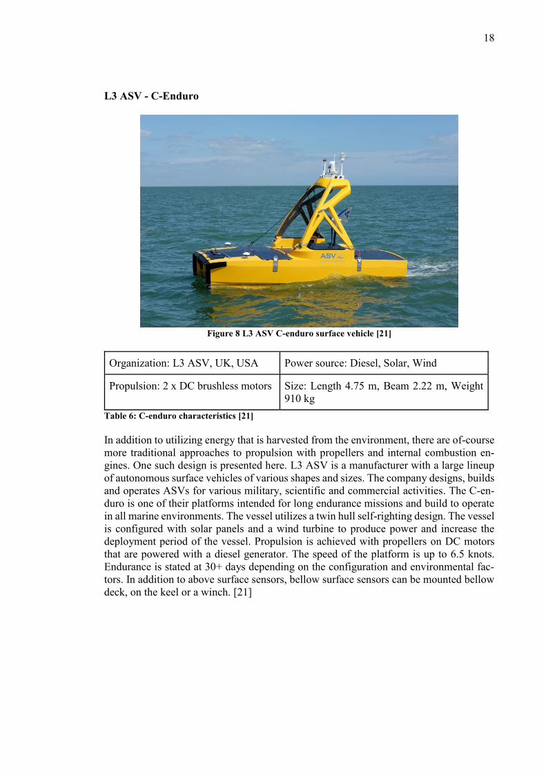
L3 ASV - C-Enduro
Figure 8 L3 ASV C-enduro surface vehicle [21]
Organization: L3 ASV, UK, USA Power source: Diesel, Solar, Wind
Propulsion: 2 x DC brushless motors Size: Length 4.75 m, Beam 2.22 m, Weight
910 kg
Table 6: C-enduro characteristics [21]
In addition to utilizing energy that is harvested from the environment, there are of-course
more traditional approaches to propulsion with propellers and internal combustion en-
gines. One such design is presented here. L3 ASV is a manufacturer with a large lineup
of autonomous surface vehicles of various shapes and sizes. The company designs, builds
and operates ASVs for various military, scientific and commercial activities. The C-en-
duro is one of their platforms intended for long endurance missions and build to operate
in all marine environments. The vessel utilizes a twin hull self-righting design. The vessel
is configured with solar panels and a wind turbine to produce power and increase the
deployment period of the vessel. Propulsion is achieved with propellers on DC motors
that are powered with a diesel generator. The speed of the platform is up to 6.5 knots.
Endurance is stated at 30+ days depending on the configuration and environmental fac-
tors. In addition to above surface sensors, bellow surface sensors can be mounted bellow
deck, on the keel or a winch. [21]

19
3.1.3 Other platforms for marine environmental measurements and sampling
In addition to the selected surface vehicles in the previous chapter, Argo floats, gliders
and moorings are briefly presented here, as they will be discussed further on in the thesis.
Argo floats
Figure 9: Argo floats drift underwater with ocean currents [22]
“The hot air balloons of the oceans”. Argo floats are a type of oceanographic instrument
used to collect temperature and salinity profiles from the upper 2000m of the oceans. The
floats utilize changes in their buoyancy to sink and establish neutral buoyancy to the sur-
rounding environment after which they drift with ocean currents. An internal pump is
used to pump fluid into an external reservoir to change the buoyancy of the floats. Typi-
cally the floats surface at intervals of 10 days and relay their data to satellites before
sinking again to repeat the cycle. Argo floats are a well-established global standard with
deployments beginning in 2000 and continuing today with around 800 deployments an-
nually. [22]

20
Gliders
Figure 10: Gliders move underwater in a sea-saw pattern [23]
Similarly to Argo floats, gliders are a type of robotic underwater vehicles that move un-
derwater by changing their buoyancy. They use an internal pump to pump oil to an exter-
nal bladder and the resulting vacuum inside the main hull to suck the oil back inside the
vehicle, causing the glider to either sink or ascend. This combined with movement of
internal weights and small wings enable the gliders to translate the vertical movement
into guided forward motion, as in Figure 10 Gliders can be equipped with sensors for
various tasks and utilize two-way satellite communications that can be used while the
glider is surfaced. While the gliders are surfaced, its progress can be monitored and
changes to the mission can also be altered. [23]

21
Moorings
Moorings are a method to deploy sensors fixed
or variable depths from the sea floor. They con-
sist of an anchor or a weight on the ocean floor
and a line to which one or more buoyant floats
are attached. Moorings can have surface expres-
sions, often in the form of buoys, which can be
equipped with communications, additional sen-
sors or power generating abilities. Moorings
that lack a surface expression above water are
called flanking moorings and can use flotation
devices to fix sensors at different depths. As
these mooring lack surface expressions, they
cannot use satellite communications and data
can be communicated via an acoustic link (a
type of underwater modem), cables to shore or
offline storage that is later retrieved with the
equipment. Moorings can utilize sensors or
other equipment at fixed depths or attached to
profilers that move up and down the mooring
line. [24]
Kuva 1 asd Figure xx. Different mooring setups Figure 11: Different mooring setups [24]

22
3.2 Further literature on other proposed use cases for ASVs
In addition to the benchmark platforms in the previous chapter, a further literature review
was conducted in search of other proposed and realized applications for unmanned sur-
face vehicles and is the topic this section. Emphasis was put on discovering documented
us cases across a broad category of industries.
Military applications have high incentives for the use of unmanned platforms. These in-
clude mine counter measure, anti-submarine warfare, surveillance and reconnaissance
[25].
Potential safety and security uses for micro USVs is discussed in [26]. A small USV
EMILY (Emergency Integrated Lifesaving Lanyard), intended for use as a small first re-
sponse unit for aiding swimmers in distress is presented. Another version, the Hurricane
EMILY platform for measuring physical parameters is also shown. The use of micro
USVs as first responders to illegal smugglers is presented as an option to reduce concerns
of manned vessels running into potentially dangerous situations. Further smuggling re-
lated uses include searching of waterways, beaches and harbors for anomalies.
Network centric operations, where ASVs are used a communications hub to provide com-
munications or analytical capability for other unmanned or deployed technologies [27].
The use of USVs for shoreline mapping with machine vision by utilizing an omnidirec-
tional camera has been tested [28]. Shoreline mapping with USVs could be used to im-
prove maps and study annual changes.
Unmanned inspections of infrastructure are another close to shore application [29].
Bridges and other pieces of infrastructure, that are in contact with seawater are especially
prone to corrosion and require periodic inspections both above an under water. Environ-
mental factors, such as strong currents are potential hazards for divers that are routinely
used to conduct inspections. Additional hazards for inspectors can be created by damages
caused by hurricanes or other weather anomalies.
Environmental disaster responses are another use case for ASVs. The 2010 Deepwater
Horizon accident was a reminder of the devastation that can be caused by oil spills and
affirmed the need for better understanding for oil spill drifting behavior. Early detection
of oil spills and real time tracking are important factors in organizing an effective re-
sponse and mitigating the impacts and methods for utilizing ASVs for tracking oil spills
have been developed [30].
The use of a fleet of ASVs for passive acoustics monitoring of fisheries has been proposed
as an alternative for replacing manned missions. With a fleet of ASVs current methods
could be improved in significantly and silent platforms such as the wave gliders have
been proposed as particularly suitable. [31]
L3 ASV’s use cases
Another notable source of use cases are manufacturers case studies, where the manufac-
turers are keen to prove their technologies. One manufacturer is singled out here and their
case studies are quickly covered. L3 ASV is currently one of the more notable companies

23
specializing in the development of ASVs. Their lineup is ASVs has been used for differ-
ent applications and many of the case studies concentrate on industrial applications such
as [32]:
Cable route surveying – A seabed survey for a marine cable routing purpose with the use
of a multibeam sonar, sub-bottom profiler and a winch deployed side scanner sonar. Cable
survey lines were covered for a total of 1220 km.
Touchdown monitoring – Utilizing an ASV as a support element for laying pipeline in the
Mediterranean, by providing subsea communications for improved location accuracy.
Coastal survey - Construction support for a breakwater structure, by utilizing a multibeam
sonar for seabed scanning.
Down well data interrogation – Data collection from gas wells with an acoustic modem.
Passive acoustic monitoring - Monitoring for detection, classification and localizing ma-
rine mamals in the gulf of mexico.
Hyrdographic surveys – Off the coast of UK.
AUV tracking – Telemetry tracking for an autonomous underwater vehicle to improve
data collection by providing better positioning and guidance data.
AUV launch and recovery – Launch and recovery of micro AUVs
Force multipliers and combined systems
In the previous oceanography international 2018 conference in London several presenta-
tions were held with connections to the use of ASVs. The information related to these
presentations the use of combined systems with an unmanned surface vehicle (USV) and
an autonomous underwater vehicle (AUV) are presented with the general idea of com-
bining the use of both platform types. The concepts appear to utilize an USV to transport,
deploy and recover an AUV, while providing communications and guidance to the AUVs
while they are deployed. From reviewing other presentations in the ‘Unmanned Vehicles
& Vessels Technical Track’, one of the general trends appears to be the visioning and
development of interconnected systems with swarms of ASVs, USV, areal drones and
docking stations. Especially the use of AUVs swarms for ocean floor mapping is a prev-
alent topic. In addition the development of
tools for supervision and guidance of un-
manned vehicles is another frequent
topic.[33]
Outside of the oceanographic, industry and
military applications, an interesting and a
particularly bold concept is the use of
WPASVs to transport renewable energy be-
tween major cities for remote islands.
Everblue technologies is a Japan-based
starup that envisions a solution for trans-
porting renewable energy by first using the
energy to produce hydrogen as a ways to
store said energy. Next a fleet of autono-
mous sailing boats Figure 12 is used to
transport the hydrogen via a distribution
network in the ocean to where the energy is
needed. [34]
Figure 12: A concept image from Everblue technol-
ogies of a hydrogen transportation sailboat [34]

24
3.3 Learnings from benchmarking
From benchmarking it is evident that the use of ASVs for applications across various
sectors has been ongoing for some time and several designs exist in various configura-
tions. Different technologies have been developed for propulsion and particularly, other
commercial platforms that utilize wind as a propulsion method exist as well. Accom-
plished and proposed applications vary across different fields and a common practice is
to utilize designs that allow for the configuration of additional equipment to better fit the
needs for different applications. Furthermore, the ASVs have been used for different
roles, sometimes as independent data gathering platform and other times as a part of a
larger network of machines or manned vessels. Some manufactures provide a service
model for access to their platform and others are selling the platform as a product. Indeed,
the designs and uses for ASVs vary across multiple dimensions.
3.4 Opportunity Identification
In this section, innovation methods are used to identify opportunities for the use of wind
propelled autonomous surface vehicles.
3.4.1 Innovation charter
From benchmarking existing ASVs platforms, it was found that their use cases vary
across multiple dimensions. Technological developments in sensing technologies and
their suitability for implementation into autonomous platforms is also a grey area. Further,
the legislation for autonomous marine vessels is evolving and being developed interna-
tionally and within local legislation, as explained in the legal status of ASVs section of
this document. Uncertainty still surrounds future legislation, required classifications and
no clear timeframe exists for the legislation.
For the work in this thesis, an innovation charter for guiding the design process is defined
as:
“Sense and develop applications for wind propelled autonomous surface vehicles, which
are attainable with current technological capability and are likely to conform to legisla-
tion of the coming decade.”
For a more thorough charter, organizational and business-oriented aspects could be in-
cluded, but due to the research project status of the ÅSR-project, these are left outside of
the charter. In the charter, ‘current technological capability’ refers to existing technolog-
ical ability, which is available and could in theory be utilized within reasonable specula-
tion. Meaning that the technological aspects for the applications, such as onboard power-
and communications requirements can be fulfilled with existing technological ability with
expectations of reasonable performance.

25
3.4.2 Mapping out the design space
An autonomous surface vehicle can be considered an entity or a platform that is capable
of observing and interacting with its environment, while traveling or holding a position
on the surface of the water. It could be equipped to sense, emit, gather or process a mul-
titude of things from feeding fish to generating hydrogen. In order to explore the possi-
bilities for ASVs, a chart in the form of a concept map was generated, by connecting
related senses and abilities that a surface going vehicle could be equipped with. The draw-
ing is presented below in Figure 13.
Figure 13: ASV senses and abilities
By grouping different aspects and considering the related sub-categories, eventually more
or less specific opportunities emerge or at least become more easily discoverable at the
end of these chains. One such example of a chain is: Emit - Electromagnetic radiation -
Radio waves - Relay node - Range extender - Local satellite node for oceanographic in-
struments without designated long range communications. It was important to have
enough links in the chain, so that the individual links could be further explored and ex-
panded on.

26
3.4.3 Early exploration of the design space
During the early phases of opportunity identification, several interns who had been work-
ing on the ÅSR-project were at the end of their internship and leaving the project. In order
to try to capture their knowledge and possible ideas, an ideation session was conducted.
The session was conducted in two phases: The first phase involved the ‘senses and abili-
ties’-drawing, which was expanded on and more importantly utilized as a tool to facilitate
an expanded mindset for the more specific goals in the second phase. 30 minutes were
spent with a facilitator guiding the ideation, with a sub task of creating an open-minded
mindset, by encouraging and supporting also the more outlandish ideas and additions.
Some of which are found in the ‘senses and abilities’ drawing. The 1st phase was con-
cluded with an individual tasks for the participants to each add 10 additions to the mind-
map in 10 minutes as seen in Figure 14.
Figure 14: A projector and a whiteboard with markers were used for the first part of this design
session
The second phase was a variation of the 6-3-5-ideation method, in which each participant
generates a rough idea on paper, which is then handed to the next person, who expands
on the idea with their input. Each idea sheet passes through each participant, giving them
the opportunity to offer fresh perspective and new additions to the ideas, without the
sometimes unbalanced group dynamics of more verbal design methods. The name 6-3-5
comes from 6 participants, 3 ideas and 5 rounds. In this exercise a 5-2-4-version was
conducted with 5 participants, two ideas per person and 6 minutes per round, until the
ideas were handed clockwise to the next person. For better tracking of the additions, each
participant had a unique pen color as seen in Figure 15 and the ‘senses and abilities’-
mindmap from the 1st phase was visible for inspiration. The task for the exercise was to
‘Ideate use cases for ASVs’.

27
Figure 15: Idea sheets generated in the '5-2-4'-exercise. Illustrations, text and different colors for
each participant were used.
After the exercise the idea sheets were reviewed by the facilitator and the most interesting
and thought provoking aspects of the ideas were highlighted. The structure and task of
this exercise were quite open-ended and the results reflected this. In many of the idea
sheets, the initial idea was taken to other directions by the contributing participants, re-
sulting in mixed direction with several add-ons. Table 7: Short summaries of the ideas
generated in the 5-2-4-exercise summarizes the ideas for applications created in this ex-
ercise.
Idea Business
sector
Description
ASV races Sport / En-
tertainment
Unmanned racing with ASVs equipped with thrill in-
voking aspects such as fireworks and weapons with-
out risks for the operators. VR-headsets for situational
awareness, possibilities above and sub-surface stages
or long-term stages with online crowd-sourced strate-
gies
Physical shuttle
services
OR
Remote aug-
mented reality
cruising
Tourism /
Entertain-
ment
Utilizing ASVs for transporting people between
places or in a cruise fashion. Also underwater to ex-
perience the sub-surface world.
OR
Utilizing a VR-headset to go remotely sailing with
friends/family in selected locations from the comfort
of your home. Also as a possible activity on cruise
ships etc. via on location launched vessel. Enhancing
the experience with augmented reality.
Mobile bill-
board for water-
side events
OR
Advertising
/ Local haz-
ard detec-
tion
Utilizing a WPASV’s sail as real estate for ads or
other promotional material for waterside events by
having the ASV cruise around at the event. This

28
Information on
possible hazards
would be a low-cost ‘spin off’ for the navigation soft-
ware with a novel and eye-catching application in an
environmentally conscious way.
OR
Utilizing a patrolling ASV at beaches to warn about
sharks or other possible hazards.
Providing inter-
net for coastal
areas, ferries or
other robots
Data com-
munications
provider
Providing expanded communications for other sur-
face equipment, people or underwater robots.
Communica-
tions node OR
Maintenance for
underwater ve-
hicles and in-
stallations
Support for
oceano-
graphic in-
struments
Acoustic or optical link for data transfer for underwa-
ter installations or vehicles. Downloading offline
measurements and utilize the ASV for periodic sys-
tems check for underwater installations without des-
ignated outgoing communications
OR
Using ASVs to transport ‘maintenance robots’ to ma-
rine installation and equipment, which would then
perform maintenance or repairs on site.
Marine farming
or processing
plant
Processing
and farming
Processing algae to biofuels of food while binding
carbon dioxide and releasing oxygen.
Oil spill track-
ing and damage
control
Environ-
mental
monitoring
Fleet of ASVs detects and calculates the origin of oil
spills. Additionally, ASVs could use acoustic or other
means to drive away fish, birds and other marine ani-
mals from the affected area to mitigate harm to them.
Similar systems could also be used for other pollu-
tants.
Environmental
cleanup or mon-
itoring with de-
ployable equip-
ment
Environ-
mental
cleanup and
monitoring
Utilizing ASVs to deploy and gather various collec-
tors or monitoring equipment. Collectors for oil, plas-
tics etc. Deploying other things such as flora or fauna.
Low bandwidth cameras or other transducers for a
real time assessment of the surroundings.
Ocean health
monitoring with
robot swarms
Environ-
mental
cleanup and
monitoring
Utilizing a swarm of bots for various tasks such as
cleaning ship hulls, tracking nutrients, protecting
small fish from predators. Swarm would periodically
return to ‘mother ship’ for maintenance or re location
etc.
Table 7: Short summaries of the ideas generated in the 5-2-4-exercise

29
Reflecting on the exercise
Reflecting on the ideas shows that they have a considerable amount of variety in several
dimensions. First, multiple uses in different business sectors were ideated. This can be
considered a reflection of the presence of different and varied activities in the maritime
environment from shipping to leisure activities. Autonomous systems then offer several
possibilities in advancing existing activities or enabling new ones. Second, it is worth
noting that between the ideas, the role in which ASVs are used varies between supporting
elements of a larger system and more exclusive roles. Third, the use of hybrid systems as
a means extend the capability of ASVs from the surface also to sub-surface and airborne
capabilities became evident. Similarly, utilizing swarm intelligence to create a system
with a larger impact than the sum of its parts was considered.
In this type of generative ideation session it is important to also consider the participants
and their background, as that will affect the results. This exercise was conducted with five
participants from the ÅSR project with backgrounds in computer sciences, mechanical
engineering, physics and management.
While it is obvious that some of the ideas generated in this session were not well defined
and highly ambiguous in terms of technological feasibility, it is evident that the platform
nature of an autonomous surface vehicle offers extensive opportunities for applications
across multiple dimensions.
3.4.4 Considerations on the suitability and performance of autono-mous surface vehicles
As discussed in previous sections, the platform nature of autonomous surface vehicles
presents a multitude of possibilities for use cases for existing and novel applications. A
rational question then is, what are the strengths and limitations of ASVs as platforms for
different applications compared to alternative autonomous systems and manned marine
conduct? Similarly, it is also important to consider the differences between wind and other
propulsion methods within the same dimensions. To support this analysis, two SWOT-
analyses for both questions were made visible in the ÅSR project environment and left
up for a few days, during which they were collaborative filled. The thoughts generated
from the ideas were used to pinpoint topics for discussions with concepts in the coming
interviews
Strengths and opportunities
Removing a crew from a surface going vehicle and replacing their tasks with automation
provides exciting opportunities. The running costs of the vehicle are reduced even on
semi-autonomous and monitored vehicles, as a single operator could oversee several
crafts. Additionally, the risks of operating at sea for the crew are also removed. Since
there is no need to facilitate for crew and their necessities on board, the size and form
factor can be better optimized for the task at hand. Further, autonomous operation can be
more cost efficient in smaller crafts, where the cost of the crew amounts to a larger portion
of the running costs. However, in longer voyages, such as in international shipping, the
cost of the crew can still make up a large portion of the operational costs. ASVs can also
be utilized alongside manned missions as a force multiplier for example in environmental

30
monitoring. This could be accomplished with a single or several vehicles deployed at the
site, or they could travel to the location beforehand such as in [12].
Limitations and threats
Removing the crew from surface vehicle does however present problems, especially with
unseen issues that emerge at sea. These include problems with maintenance and repair. If
something breaks or for example gets tangled, there is no crew to respond to the situation
and consequently the vessel might become impaired, adrift in the water or even sink.
Moreover, a damaged ASV might also put other vessels in danger. Communications to
and from the ASVs become restricted if the vehicles venture far from coasts, as the band-
width for data communication is greatly reduced when operating outside of the cellular
networks since satellite communications are required. The development of autonomous
surface vehicles faces obstacles in navigation, collision avoidance, complying with
COLREGs and facing environmental disturbances. Other less likely scenarios include
vandalism and even theft. Particularly cyber theft of information or hacking of the vessel
are noteworthy threats of ASVs. Finally, the ongoing development of unmanned aerial
vehicles might also turn out to be disruptive for some applications of ASVs.
3.4.5 Wind propulsion for autonomous surface vehicles
No running costs from crew or fuel and essentially unlimited range and deployment pe-
riod with zero emissions. These would be the main strengths of a fully developed wind
propelled autonomous surface vehicle.
When considering the limitations of WPASVs compared to other propulsion alternatives,
the inability to compete in speed is among the first considerations. The maximum speed
of current small WPASVs from benchmarking is about 5-8 knots and this is directly re-
lated to the vessel’s size and waterline. Where as any fast motorized boat can theoretically
be fitted with an autonomous system that could then exceed speeds of 50+ knots. Further-
more, wind propulsion is also dependent on the variable wind conditions. If there is little
to no wind, there is little to no movement of the vessel and even if there is wind it has to
be from a favorable direction in relation to the desired heading of the ASV.
However, what WPASV lack in speed, they can make up in endurance. Harvesting energy
from the environment with sails offers an almost always present, albeit inconsistent,
source of energy for movement. This combined with other means of gathering energy for
electronic systems makes is possible to deploy WPASVs for extended periods, notably
the Saildrone and SailBuoy enabling missions up to 12 months [9][5]. Since propulsion
is provided by wind power, a WPASV could also carry more energy as its cargo compared
to vehicles that are propelled via electric or combustion engines. As they have to transport
their energy for movement onboard. The ÅSR prototype ASPire utilizes a free rotaring
wingsail for propulsion. When compared to traditional sails, wingsails have a higher ef-
ficiency, can be self-trimming and require less actuation force [35]. This makes them
highly suitable for autonomous long-term deployments.
There are also other methods to utilize wind for propulsion and to harvest energy. Flettner
rotors are another simple method that utilizes a tall cylinder that is spun along its long
axis and the Magnus effect causes lift that is used to propel a vessel. A more complicated

31
system for wind propulsion is the use of wind kites that are flown from a vessel and need
more complicated inputs. In addition to propulsion, wind can be utilized to generate elec-
tricity with wind turbines, one such example is the C-Enduro ASV as described in the
benchmarking section.[36]
The physics of sailing call for correcting for the momentum from the sail by counteracting
the roll of the vessel. With sailboats a keel is most often used for this purpose and conse-
quently the draft of the vessel is increased. Using a deeper keel increases the draft and
limits the depth of the water in which the vessel can operate. This limits the possible area
of operation, especially in coastal waters. However, this issue can be mitigated by utiliz-
ing a multi hull design (catamaran and trimarans), with a telescopic keel or a pivoting
keel to provide variable draft. All of these options are common practices in with sailboat
designs. Generally, wind propelled surface vehicles are less agile and have less control
for movement. As such, WPASVs without additional propulsion or control actuators are
underactuated and this presents a challenge for precise control [37].
When discussing wind propulsion, it is also important to consider other options for har-
vesting environmental energy for propulsion. Wave energy is another method to harvest
energy from the environment. The AutoNaut and Wave Glider platforms presented in the
benchmarking section are platforms that utilizes wave energy for their movement
[16][19].
The lack of noise from propellers also provides a well-suited platform for acoustic listen-
ing applications, since background noise is reduced. The reduced noise pollution beneath
the surface should also reduce the stress that is exerted to the environment. This might be
an advantage for example in environmental fish stock monitoring with sonar, since the
fish would likely be less disturbed by the vehicle, resulting in observations in more natural
habitat. Another suitable application is PAM monitoring further discussed in the last two
interviews of this thesis. The lack of pollution also extends outside of noise pollution. A
wind propelled ASV does not pollute with exhaust gasses or motor oils, further reducing
its impact on the environment. Many would also consider the silent gliding of a wind
propelled craft a more compelling sight. The advantages that could be gained from re-
duced noise are discussed in 4.4.1 and 4.4.2.
3.4.6 Considering trends
One of the methods for opportunity identification is to consider relevant trends and more
importantly their implications [3]. For this reason, some of the current marine related
trends were ideated among the ÅSR employees and are documented here.
United nations decade of ocean science
The United Nations recently announced the Decade of Ocean Science for Sustainable
Development (2021-2030). The goal of the initiative is to support efforts to reverse the
cycle of declining ocean health. The decade is set to begin in January 2021 and UN is
currently looking to gather stakeholders for the initiative [38].

32
Growing concern and interest in microplastics in the oceans
Probably you the reader have at least heard of the massive garbage patches in the Pacific
Ocean, where plastics are trapped in ocean currents and slowly decay into smaller pieces.
Plastics and more specifically micro plastics have been a source of increasing outrage and
concern during the last couple of years and concepts and solutions are being generated on
how the oceans could be cleaned. As such ASVs could be a viable option for cleanup
efforts.
Fish populations at risk
Another environmental topic that was brought up was the concerns of fish populations
due to over fishing and pollution.
Big data analytics
This has been a more prevalent topic concerning privacy issues with our everyday uses
of smart phones and other connected devices. With companies seeking to gather and an-
alyze massive amounts of data from multiple sources, the tools that are being developed
for these purposes might also be adaptable to the needs in the marine science fields with
goals of mapping and better understanding the marine ecosystems.
Ever increasing shipping and offshore energy sector in the oceans
In addition to trade expansions requiring more shipping, the offshore energy sector is also
expanding with an emphasis on increasing demand for sustainable energy sources such
as wind farms [39]. These developments are going to put a larger strain on the oceans,
but also open up new opportunities for autonomous systems for supporting roles.
Automation is here
Different levels of automation are commonplace across manufacturing sectors and with
the emergence of autonomous vehicles, it only makes sense that the technology is ripe to
also apply in the marine environment. This combined with the increasing cost of human
labor makes the prospect of autonomous ocean vessels even more appealing. It was
brought up that maintenance activities are still mainly a human effort, so there might be
a coming paradigm shift in the role of workers.
Renewable energy from oceans
With the pursuit of establishing more offshore wind farms and utilizing wave energy,
these offshore installations could have latent needs for mobile autonomous for mainte-
nance or other applications.
Hacking
If and when the oceans are filled with unmanned vessels for shipping and other applica-
tions, surely there is a concern for someone to hack into the merchant ship reconfigure it
for nefarious purposes. This could also be true for smaller platforms.

33
Open source initiatives
As robotics become ever increasingly commonplace and attainable, it is very likely that
open source communities will gather around autonomous vessels and might create a need
for a platform design. This idea is also somewhat reflected in the ‘Early exploration of
the design space’ section of this thesis.
AI
With the constant development of artificial intelligence and self-correcting models a self
correcting-model and autonomous vessels are a great combination.
3.5 Expert interviews for opportunity identification and need-finding
In order to support the internal product development within the ÅSR project, a series of
interviews were conducted with representatives from the project’s partner companies and
other outside contacts. The objectives of these interviews varied from opportunity identi-
fication, needfinding and gathering expertise on the technological and legal challenges
facing the development of autonomous surface vehicles.
3.5.1 Method planning for interviews
Planning of the interviews was done by first recognizing different areas of expertise, from
which input should be gathered. Then professionals of the field were sought and requested
for an interview. The interviewees consist of some that had been in previous contact with
the ÅSR-project and some that were contacted for the first time for the interviews. After
the interviewees granted an interview, more specific goals, topics and questions were
prepared for that particular interview. The format of the interviews was preferably either
face to face or via a video call. This was so that the interviews could have a less rigid
structure and interesting ideas could be better recognized and followed during the inter-
views. This is one of the main reasons that interviews were chosen as a method for the
opportunity identification and needfinding activities with the experts. Interview guides
were prepared for each interview in a way that the interview questions would approach
the goals of the interview by working from ‘outside to inside’. More detail-oriented ques-
tions were preceded by broader topics. The reasoning for this flow was to give the inter-
viewee some time to consider the relevance of the broader topics with regard to more
detailed questions and using more open-ended questions to precede the sometimes am-
biguous topics with no right or wrong answers, a warm-up of sorts. Further, the method
was used as an effort to gain a more holistic understanding and context of the possible
implications of the more detailed oriented answers.
Even though interview guides with pre-prepared topics and questions were made, the
possible shortcoming of strictly adhering to these was that some promising directions
would be overlooked and never discovered. This was especially likely in these interviews
where the topics and questions of the interview were prepared by an interviewer from
outside of the interviewees’ area of expertise. The possibility of not asking the right and
34
most relevant questions, due to lack of understanding or empathy of the interviewees field
was high. In preparation for avoiding this problem and ultimately gaining better insights,
the topics of the interviews often deviated from the interview guideline, when interesting
topics arose during the interviews. However, in an effort to ensure a more holistic cover-
ing of all of the interview goals, the interviews were guided in a way that all of the pre-
prepared topics were discussed at least on some level, even though this sometimes meant
cutting some fruitful conversations short due to time constraints. It is worth noting that
due to the novelty of the technology combined with a pursuit for opinions, the answers of
the interviewees should not be held as absolutes.
The interviews are presented in the following format. First, the motivations for the general
interview topics are reasoned. Followed by a short introduction of the interviewee. Next,
the more specific interview topics are explained with their motivations. The contents of
the interviews themselves are then recounted. After this the contents of the interviews are
then briefly analyzed with the goal of better understanding the implications of the opin-
ions of the experts, with regard to the interview goals and also in the broader context of
this thesis.
3.5.2 Master mariner and project initiator, Ronny Eriksson
Designated as [40]
Ronny Eriksson is the initiator of the ÅSR project and was the lead of the project from
its early years in 2013. Therefore, it was worth to gather his ideas on the background of
the project and possible thoughts on the applications and about general conduct in the
shipping industry.
The project begun in 2013 with thoughts on project for the university. From his profession
Mr. Eriksson derived issues with shipping and ship owners who are always concerned
about fuel costs and personnel costs. For fuel, wind could be used instead, and autonomy
could cut costs on personnel. He discovered that others had had similar ideas and com-
munities had developed around small autonomous surface vehicles. In the beginning of
the project goals were set for transatlantic crossing, but the motivations were in technol-
ogy development for robotic sailing. Early work was done with small available remote-
controlled sail boats. After a while, funding was gathered for the marine research platform
project and the goals shifted onto the development of a marine research platform.
Mr. Eriksson explained that in 2013 the discussion on automatization on vessels was
very sparse. In 2014 Rolls Royce promoted autonomous vessels and after that the mar-
ket and interest dramatically increased across shipping and sailing applications. The
shift in thinking has been very fast. Wind propulsion and the suitability of it was then
discussed. For ships the speed-energy-curve is exponential, meaning that in order to in-
crease the speed by little, the energy has to be increased a lot. The implications of this
are that for wind propulsion applications the speed has to be quite low since wind en-
ergy is limited. Designs do exist for fast wind propelled crafts, but if the capacity to
carry cargo is desired, then the speed has to be low. With shipping applications, the
cargo would have to be low value cargo, or at least promptness of delivery cannot be a
high requirement. Other technologies, such as wind kites have been in development for
large ships, however they are expensive and complicated to use. Flettner rotors a low

35
maintenance alternative, but they have low efficiency. The wind propulsion is further
discussed in the 3.4.5 section of this thesis. Another consideration is generating power
from wind and the most efficient method is to use a wind turbine. This could also be
used for propulsion through an electric motor, but there are losses in energy conver-
sions. Next the topic shipped into the applications for ASVs and Mr. Eriksson thought
that the first ones would be research related data collection activities. However, as this
is a new industry and the technology is not yet mature enough to be profitable. As soon
as the technological challenges are addressed for the technology to become profitable, at
that moment larger companies will have incentives for development and will likely
adopt the technology at a much larger scale. If you have means (technology) and an in-
centive (cost reductions, efficiency), then combining the two for profitable ventures will
be highly coveted. Autonomous vessels are a highly disrupting technology and will
change the maritime paradigm in the long run. No costs from the crew or fuel, would
lower the cost of expansion basically to the cost of the unit. If there were an established
pier to pier route, the expansion of that could be done with little effort by simply adding
vessels. With this type of system traditional manned ships could not compete, with the
exception of expedited delivery with other faster technologies. Further, Mr. Eriksson
explained his views that commonly with disruptive technologies people have tendencies
to overestimate the timeframe when it is coming and underestimate the impact of the
technologies. This has already happened in the sipping sector, where previously crews
would be 40-50 people and today the same sized ships are run with crews of 10-12 peo-
ple as there is a commercial interest for reducing crew costs. An issue with unmanned
conduct in the maritime environment is in the juridical side, insurances, owner contracts
etc. Many of the contracts and processed used today are very old and the changing of
the will be difficult and time consuming. Who takes the risks of liability and other is-
sues need to be addressed.
Discussion
The paradigm shift and the disruptive impacts from the autonomous shipping applica-
tions were an interesting conversation. This interview also shed light into the legislative
issues in the maritime environment, where rules and regulations have been made for
manned ships. The legislation is certainly one of the larger non-technology related is-
sues regarding the use of ASVs and is further discussed in 4.2.
3.5.3 Husö biological station Amanuens – Tony Cederberg
Designated as [41]
For the 2016-2018 ÅSR project a goal had been set to develop a marine research platform
for environmental observations. One of the partners in the project is Husö biological sta-
tion located on the Åland Islands functions under the Åbo Akademi University. Among
other research, the station functions as the base for aquatic studies for the University. The
station is also part of the network of Finnish Research Stations and the Finnish Marine
Research Infrastructure FINMARI [42].
An interview was held with Tony Cederberg, an Amanuens at the station. Goals for the
interview were to gather a better understanding of biological research activities, research
objectives and equipment that is by the researchers. Further, an area of interest was to

36
understand what types of issues are limiting factors in the stations’ research in order to
possibly discover applications for ASVs, since it was expected that an unmanned platform
might be of interest to reduce the time-consuming work done by researchers.
First, Mr. Cederberg was asked to describe some of the station’s activities and history.
The research activities of the station have varied over the years since the establishment
of the station in 1959, with recent emphasis on shallow bays, introduced species and cli-
mate change among other things. A portion of the the research is basic marine and lake
research as mandated by the European Union’s (EU) water framework directive, since
the Åland isles in this regard are considered an independent state with subsequent obliga-
tions. Much of the research activities at Husö are for establishing basic understanding of
the state of the environment, as they are the only ones doing this type of research in the
Åland isles and ground work has to be done for more detailed research activities to take
place. Thus far most of their sampling equipment has been quite rudimentary and manual
equipment. Examples include manual water ‘traps’ enabling the gathering samples at dif-
ferent depths and similar equipment for gathering bottom soil samples, which are then
analyzed at the station or sent to other laboratories. They have planned to invest in more
technology-based equipment in the coming years. The interviewee pointed out that alt-
hough several new types of products have been introduced to the market in recent years,
the high cost and expectations of more advanced and affordable versions of these products
that are sure to follow have been the main reasons for waiting on the investments. For
biological research novel technologies include Lidar lasers for underwater habitat map-
ping and the use of airborne methods for optical data gathering for shallow bays. Husö is
likely going to acquire a drone for this purpose in the close future.
The high cost of some of the available equipment compared to their performance has also
lead Husö station to develop equipment themselves. In recent years the station has con-
ducted vegetative research with a self-made drop video system. The system consists of a
submersible part with a camera and optional lights seen in Figure 16. The submersible
part is connected to the surface with a tether and a cable that sends live video to monitors
that are used to position the camera in the water manually. The camera records video to
a memory card as it is towed with the boat from which it is deployed, and the locations
and directions of the towing runs are recorded. The traditional alternative for this method
is diving, from which more accurate data is produced, but with considerably more effort.
The drop video-method is a good way to get large amounts of data from the subsurface
habitat fast and with relatively low effort. This is utilized up to 30 meters deep, but gen-
erally bellow 10 meters the vegetation becomes very sparse. Other more technological
alternatives for gathering information on the state of bottom vegetation include side-scan
sonar, that can produce information on the vegetative density, volume and bottom type.

37
Figure 16: Submersible part of an action camera-based self-made dropvideo system developed by
Husö biological station with an image of the bottom [43]
One piece of automated equipment that Husö has as a part of the FINMARI initiative is
an automated moored profiling surface buoy, often deployed in the outer archipelago at
sites of interest. The buoy is equipped with two-way 3G communication and measures
the vertical water column at programmed intervals, typically a few times a day between
4-40 meters with a winch and sends the data back to shore. Different sensors can be
equipped and often include dissolved oxygen, chlorophyll, temperature and salinity. A
wish for this particular piece of equipment is to improve the user interface for near real
time monitoring and visualization. The profiling buoy is a good way to produce data from
the water column, but it is highly localized. Manned missions can be used create better
resolution, but they are costly and coverage in time is also desired. A sailing robot might
be a suitable technology for this need. Generally, the need for more real time data is de-
sired. If the data is offline, then extra work comes from the analysis of the bulk of data
that is recovered at once. Other smaller pieces of unmanned technologies utilized by Husö
include temperature and light loggers that can be left in the environment to record and
data is later recovered.
The gathering of water samples was discussed during the interview. They are gathered
for many purposes, some are mandated by EU and others are for general research pur-
poses. Some of the measured parameters, mainly temperature and secchi depth (water
visibility) have to be measured at location and dissolved oxygen needs to be stabilized in
the sample with chemicals as it will otherwise begin to change. In addition, other param-
eters; salinity, pH, chorophyll, phosphorous, and nitrogen are measured in a lab. A wish
would be to increase the capability to do more of the measurements in-situ. However, the
mandated measurements three times a year would still need to be conducted with defined
methods and therefore better in-situ sensors could not replace water samples for this pur-
pose. If ASVs could do more in-situ monitoring it would be helpful to reduce the manned
labor and generate more ‘background data’ that is currently left undone.
Considerations for ASVs for biological research from Husö’s percpective
From Husö’s perspective acquiring an ASV would depend on the performance and capa-
bility of the vessel. Especially, this has to be compared to the cost of manned missions.
In order for the investment to be worthwhile, it has to improve on the current methods.

38
Another consideration of high importance is the ability to modify and expand the capa-
bility of the vessel for future work and this ability would make the platform much more
desirable. Currently for a small ASV, the acquiring price could be around 100 K € if
bought and the cost for a service model, where the platform would be rented, or capability
provided with outside missions is difficult to price. It was mentioned that if the station
were to acquire an ASV for research use, other stakeholders, such as fishers would likely
be interested in the data as well. When asked about suitable payload capacities for an
ASV and the OceanAero’s 23 kg payload was used as a reference, Mr. Cederberg thought
that 23 kg might quickly become too small and a higher capacity would be desired. Cur-
rently the buoy described before has a payload of 15 kg for sensors, but additional payload
capacity for batteries and control equipment.
Discussion
Based on the interview, ASVs could be used for increasing research capabilities by re-
ducing manned efforts. Since sampling is time consuming with manned missions, it is
only used to the needed capacity. Unmanned technologies, such as buoys and loggers can
be left to sample the environment, but the results are highly localized. Further, if the
equipment is not connected to produce near-real time data the data analysis from the re-
covered equipment can become a demanding task. Therefore, ASVs with connections to
shore could be used to produce more data at a considerably lower effort and both spatial
and temporal coverage would be improved on. Suitable technologies for an ASV would
include physiochemical sensors, and the capability to lower them to the water column for
vertical sampling. Technologies also exist for underwater habitat mapping with the use
of Lidar and side-scan sonar that could be equipped into the ASV to gather information
on the vegetation and bottom topography. These technologies can be expensive, but for
an ASV, the costs might be rational. With more development, collaborative capability of
an ASV an unmanned aerial vehicle system would provide enhanced capability. Since
some of the mandated monitoring activities require the use of specific methods and tech-
nologies, ASVs would not necessarily add value to them. From a cost point of view, the
overall cost and capability of an ASV has to improve on the exiting methods and reduce
overall costs to be on interest. High cost of technologies is an issue for organizations with
limited funding an incentivizes them to innovate solutions for themselves, such as the
drop video method described in this interview.
3.5.4 An expert in environmental observations
Designated as [44]
In addition to biological parameters, the physiochemical parameters of the ocean envi-
ronment, including water and weather are also monitored for various applications. ASVs
may present a viable alternative for improving on the existing methods and a better un-
derstanding for their use and requirements was desired. For this purpose, an expert in
environmental observations was interviewed. The expert has over two decades of experi-
ence in both marine and atmospheric observations. In addition, the expert has extensive
experience in the hardware and software solutions required for both fields. For this inter-
view the expert wished to remain anonymous.

39
First topic of the interview was to gather a better understanding of what methods are
currently utilized to produce data from the marine environment in the Baltic. Current
methods for gathering ocean related data include, wave buoys, profiling buoys, remote
sensing with satellites, ‘ferrybox’ equipment and flow through equipment onboard com-
mercial ferries. Ferryboxes are a type of system, where water is pumped from a sub-sur-
face inlet that is then slightly processed before entering an internal loop, where sensors
for different parameters can be installed [45]. Further, the water can be guided through
more complicated systems for analyzing biochemical composition. Water samples can be
stored for further analysis and the excess water is pumped back to the ocean.
Considerations for a platform for oceanographic use
The topic of a platforms design for scientific research was discussed during the interview.
The expert said that modularity for instruments would be the best practice. For a modular
design where equipment can be changed, the interfaces within the vessel have to been
well thought out. Further, the exchanging of the equipment has to be made simple and
established modularity standards should be followed for size, data formats and power
needs. The instruments themselves should be acquired from well-established manufac-
turers. With the ocean environment, problems with calibration drift and biofouling are an
issue. With different technologies, the calibration times and susceptibility for biofouling
do vary and can cause issues with the quality of the data if some of the sensors are still
good and others require maintenance. Methods for preventing biofouling include mechan-
ical wipers, UV-light, anti-fouling paints and electrical currents. Among suitable technol-
ogies for ASVs, acoustic doppler profilers (ADCP) were mentioned for current measure-
ments. Also, the use of flow through equipment, where water flows through a section
which is equipped with other sensors was suggested. In terms of how the platform pro-
vides data for the end users, the method must not be a ‘black box’ that produces data that
has been formatted in a way which the operator does not disclose. I.e. the raw sensor to
data has to be made available for the users of the data. This was said to be especially
important for serious scientific research that might later be used for legislative purposes.
Generally, researchers and other purchasers of oceanographic data are more likely to pur-
chase equipment or data from well-established manufacturers since the future user sup-
port is better and the providing company will be in existence for the coming years or
decades as they are less likely to go bankrupt.
Limitations and obstacles for autonomous surface vehicles
Ambiguity relating to the legislation for use of ASVs is currently too constraining and
consequently too costly. The interviewee clarified that they were not familiar with the
current detailed legislation, but a conversation was held on the general prevalent legisla-
tive paradigm in the Baltic environment. There are lots of limitations for operating un-
manned surface vehicles outside of designated test areas and generally having a visual
line of sight is required. If the vessel is remotely piloted a qualified pilot, likely a master
mariner, has to oversee the operation 24/7 and the implication of this is that the costs of
overseeing a single ASV become too great. A solution for this would be that several plat-
forms are monitored concurrently, thus reducing the operational costs per platform. The
goal would be to drive the operational and oversight costs per unit to an acceptable level.
With increasing use of ASVs a centralized operations center run by service providers or
even by governments could be utilized. Since ASVs currently require supervision, further

40
operational expenses will also come from communications when operated outside of cel-
lular coverage. This is since satellite communications would need to be used and the use
of iridium satellites is rather expensive and bandwidth is low. As the issue of costs is ever
prevalent in oceanography, the currently utilized methods have already been developed
to be cost effective and proven technologies. In order to compete with the existing tech-
nology in a commercially viable way, the total costs of ASV operations will either have
to reduce the costs or be utilized in niches, where the current models are lacking.
During the interview several more detailed use cases for ASVs were discussed and are
categorized here. It is worth noting that additional capability could and should be added
where applicable without hindering the original task or raising costs needlessly.
Deployment, retrieval or other interactions with existing equipment
The costs of transporting and deploying equipment in the marine environment have al-
ways been high due to the needed personnel, vessels and time and reducing this would be
highly desirable. Along the Finnish coast, networks of wave buoys and other surface
equipment have to be retrieved and deployed annually due to the ice coverage. In addition
to these tasks, maintenance operations are also needed for the bottom mounted equipment
thus further increasing the costs of maintaining the equipment. Similarly to buoys, Argo
floats have to be manually deployed as they drift with the currents. A higher utilization
of the floats is desired, but held back partially due to the costs of deployment and retrieval.
In addition, other maintenance operations such as charging deployed equipment would
be a possible development direction. One of the use cases for ASVs would be to interact
with other deployed equipment. Bottom mounted equipment could be inspected with
more periodically, with the use of an acoustic modem or light data transfer closer to the
bottom. This would enable more timely systems checks and data download from equip-
ment that is otherwise not connected to shore.
Wave measurements
As mentioned above, the costs of deploying wave buoys is high, 10-20K € per buoy for
the larger ones as estimated by the expert. Therefore ‘virtual mooring’ of a wave meas-
uring ASV could be a suitable application. In virtual mooring, the ASV would maintain
its position in a designated area and produce real time data. In order to be a worthwhile
application, the data quality would have be up to par with the current buoy-based meas-
urements, as their data is used by multiple stakeholders such as ship pilots, whose safety
depends on the reliability of the data. The best design for a wave measuring device is a
circular shape due to the physics of wave measurements, where the measuring device has
to react to the waves. There are GPS and accelerometer-based methods and generally the
accelerometer-based methods are more accurate. This would further assert the need for a
hull design that would likely be in a conflict with an ASVs capability to sail and maintain
position. For shorter measuring campaigns for other research purposes an ASV might be
utilized with less accurate results. An ASV for wave measuring tasks via station keeping
could also be equipped with other sensors. The expert suggested surface CTD parameters,
current profiling and marine weather along with possibilities for modularity. When asked
if the expert saw any strengths in a moving platform for wave measurement, they did not

41
see it as particularly helpful for day-to-day observations, since wave measuring cam-
paigns require data from a single location over a longer period of time, but for campaigns
it could be useful.
Depth profiles
Data requirements for the basic ocean surface measurements are currently covered with
remote sensing (satellites) and established buoy networks. Consequently, better coverage
of depth profiles of the water column is highly desired across multiple parameters and
stakeholders. At the very least the basic parameters conductivity, temperature and depth
(CTD) should be covered. With established methods, more Argo floats could be used for
this task. Additionally, gliders are also an option, but they are more work intensive and
have higher operating costs than Argo floats. Moreover, gliders do not work well in the
5-50 meter depth range, which covers a large portion of the Baltic. Therefore, a suitable
niche for surface vessels would be oceanographic data for this upper water column where
other methods are lacking.
Marine weather
A better coverage of marine weather from more points is desired. However expanding the
network is difficult, due to issues such as electricity requirements, data transfer connec-
tions, ice coverage and maintenance.
Current trends with ASVs
The interviewee had conducted research into the currently available ASV-platforms and
explained his views on some of the current trends with the technology. First, there is a
paradigm shift to move from complicated and expensive platforms to first choosing the
desired equipment types and methods and then a platform that can manage the use of said
equipment. The end users are not interested in paying for redundant capability if it is in
conflict with the costs of the platform. Interestingly, the platforms might even be less
expensive than the equipment that they are equipped with. Regarding the equipment itself,
‘plug and play’ is desired by the market.
Discussion
For day-to-day observations of the marine environment, networks of various connected
equipment are used. Wave, wind and current conditions are established with networks of
moored buoys that are connected to the shore and procure real-time data for various stake-
holders. Bottom mounted instruments are also used to better observe currents. The avail-
ability and quality of the data has to be absolute and real-time as it is used to assist in
safety related decision making for recreational and commercial use. Additionally, remote
sensing technologies are used to observe the top level of the oceans and to produce models
of the marine environment in a cost-effective way. The availability of commercial traffic
is also utilized for data gathering with equipment that is installed into ferries. For more
campaign-oriented data gathering other instruments such as Argo floats and gliders are
used as well. The annual ice coverage in the Baltic environment sets limitations to the

42
deployments of the moored instruments as they have to be deployed and retrieved accord-
ingly. These operations are costly require the use of manned vessels. Thus, the concept
of ASVs for use instead of buoys is an alluring one as the deployment costs would be
much less than the deployment and retrieval of buoys. However, in order to for ASVs to
compete against these current methods, they will have to be proven for reliable data pro-
duction. Additional capability should be added to the ASVs in order to improve their
performance. For other uses, such as vertical depth profiles, ASVs are a noteworthy ap-
plication to improve on the shortcomings of other autonomous vehicles. For use in the
close future there are issues with the ambiguity and restrictiveness of the current legisla-
tion, that present additional costs from oversight of the unmanned vehicles and this should
be addressed with centralized operations.
3.5.5 Naval engineering company ASCE – Tage Lindfors
Designated as [46]
The marine environment presents variable environmental conditions, which are sometime
very rough. An ASV has to be able to survive the conditions in which it is deployed and
high performance is desired for navigation capability. ASCE, a naval consulting company
specializing on stability calculations had previously conducted stability calculations for
the ASPire prototype and an interview was held with Tage Lindfors and another repre-
sentative from the company in order to gain a better understanding of design considera-
tions for small surface vehicles.
Mr. Lindfors began by stating that for a small autonomous sailing ship one of the most
important considerations is that the ship is basically unsinkable. This requires a self-right-
ing hull and further that there should not be openings on the deck of the ship, where water
might enter. The self-righting abilities for the ASPire are achieved by having enough bal-
last in the keel. For this interview pictures of the Saildrone, SailBuoy and Ocean Aero
were brought as references to discuss the different hull designs and their performance.
Generally, a longer ship is steadier than a smaller one which will be fluctuating more
from the environmental factors and puts a larger strain on the guidance systems.
For ship and vessel designs, naval architectural programs are used to model the designs
and conduct stability calculations. Another consideration is the desired payload capacity
(deadweight) and the smaller the vessel is the smaller the payload will be in relation to
the total weight of the vessel. Furthermore, smaller designs are more susceptible to issues
when overloading the designs. The question of defining the payloads is an issue of opti-
mization that has to be figured out in the very early phases of vessel design. As the use of
ASVs for transporting other equipment had been discussed before, a question was pre-
sented on how the movement of a vessel changes depending on the loading of it. The
width or the beam of a ship is the most important consideration for the stability of a vessel,
a higher beam will improve the stability, but in contrast it will also reduce the forward
speed of the vessel. A slenderer design will improve the speed but reduce the stability.
Furthermore, multi hull designs are great at improving stability, but they risk the highly
coveted self-righting capabilities. Whichever the payload, it should be placed midship
and as low as possible for best performance. Next suitable practices for small vessel de-
sign for high performance with adequate withstanding of adverse conditions was dis-
cussed. No magical solutions exist for a design that can do everything. Vessel design is

43
always a compromise and therefore it its highly important to figure out the desired char-
acteristic in the early phases of ship design, whether a higher payload capacity or better
maneuverability are desired. Another important consideration is the intended environ-
ment. In the Baltic sea the conditions are considerably different from the Atlantic and
vice versa. Generally, in the north Atlantic the waves are bigger and longer than in the
Baltic, where the waves are smaller and steeper resulting in a higher angle of encounter.
For a smaller ship it can be more difficult to maneuver in shallow waters and if the wave
length is similar to the vessels length there will be big issues in the ability to navigate,
especially for an autonomous system.
Discussion
This interview affirmed the need to specify the intended use cases early on in the designs
process of a vessel. If the parameters for desired payload variation are well defined during
the early phases, a better performing platform can be engineered. Further, the desired
environment should also be defined well, especially for wind propelled ASVs.
3.5.6 Researcher at a solar solution company HelioZenit Ab - Mikael Olsson
Designated as [47]
Whatever the purpose of an autonomous surface vessel, electrical power is needed
onboard. One of the partner companies of the ÅSR-project is the Åland based company
HelioZenit specializing in solar tracking systems. Mikael Olsson, a researcher from the
company had been working with the ÅSR-project in 2016 and 2017 with the design, plan-
ning and implementation of the ASPire prototype’s power system. Therefore he was re-
quested for an interview regarding power considerations for an ASV. The interview was
in the form of an email questionnaire and the answers are presented here in a question-
answer format.
Solar as a power source
Question: Of the available solar panel types, which ones do you see as the most suitable
for applications in ASVs in the salt-water environment for prolonged deployment?
Answer: All common solar panels use an aluminum frame and glass on top. The alumi-
num will take a beating over the years due to the salt water, but it won’t affect the per-
formance of the panel. The solar cells are well protected by the glass on top and the
plastic on the backside. Due to space constrains, high efficiency (mono-crystalline) pan-
els are preferrable, such as LG Neon 2, BenQ Sunforte or SunPower. These have 20-21%
efficiencies compared with ordinary panels with 15-17% efficiencies. These HQ panels
cost 30% more per watt.
Q: Is utilizing solar panels for energy at sea different from utilizing them at land, e.g.
reflections etc?
A: The utilization is the same at sea as on land: the panel(s) are connected to a solar
battery regulator which in turn connects to a battery array. However, at sea the panels
44
are typically placed flat and not optimized towards the sun as in the case of fixed instal-
lations on land. Flat panels get more cosine losses than south facing tilted panels, to the
tune of 0-20% less energy depending on the latitude. The higher the latitude, the more it
pays to tilt the panels, whereas on the equator a flat panel is the ideal. There are also
sources of shade at sea that may be unavoidable, such as shading from the sail/mast.
Q: How considerable are the differences in available solar energy depending on the time
of year and location and is this difference directly proportional to the amount of energy
that can be harvested with solar panels?
A: There’s a direct relation between the amount of sunshine (light hours/year) and the
energy yield. 5-10% of the solar energy comes in as diffuse sunlight reflected from the
ground and atmosphere, but the bulk of the energy comes from direct sunlight hitting the
panels.
The higher the latitude the larger the difference becomes. Here in the south of Finland
80% of the solar energy comes in during the summer half of the year, and less than 1%
during Dec-Jan. The further south you go the less seasonal variation you get. The sea-
sonal differences near the equator are far less noticeable.
Application types, flat or curved panels
Q: Many of the suitable areas for solar panels on sailing vessel can be single or double
curved surfaces (for example along the wingsail), is this an issue, or is it a requirement
to have flat surfaces for panels?
Is there an increase in cost and weight and reduction in efficiency when using multiple
smaller panels versus one big panel?
A: We considered using flexible panels on the wing sail instead of the more common
framed type of panels. Since the wing sail would have to rotate 360+ degrees this became
needlessly complex so we opted for the hull mounted panel instead. Ideally, each solar
module should have the same amount of sunlight, hence the flat panel is the best in terms
of performance. Flexible panels have slightly less efficiencies overall, and when placed
on a curved surface the part of the module with the least amount of solar intensity will
reduce the yield also for the part of the module receiving more solar intensity. So if there's
much of a curve multiple rows of separate modules will give better performance than a
single curved module. The weight of flexible panels is low and otherwise unusable parts
of the vessel can be utilized so it’s a very good idea to use flexible panels if more power
is needed.
Maintenance needs
Q: Do you think that the use of solar panels on ASVs at sea presents some special mainte-
nance or operational requirements?
A: Solar panels are extremely low maintenance compared with other means of generating
power. In places with heavy pollution or sandstorms you need to clean them, but not even
that would be necessary for an ASV-mounted panel.
The batteries however need to be kept from being completely drained as a discharged
battery left alone depletes its lifetime in a matter of weeks.

45
Advantages and challenges
Q: How to you see solar powers advantages and limitations compared to other available
power sources at seas, e.g. waves and wind?
A: Wind turbines are a good complement to solar panels at sea, since unlike panels, tur-
bines can generate power throughout the day. A single turbine is more space-efficient
than a panel, but unlike solar you cannot place multiple turbines close to each other. You
won’t get a lot of power from a small turbine and the power will vary greatly with the
wind speed and wind turbulence. Turbines also require a lot of maintenance, more so
than any other mainstream way of generating energy. The turbine can be connected to
the same battery array as the solar panels, with a wind-charge controller in-between. I
haven’t tried wave power, only wind. We considered using a small vertical axis wind
turbine for ASPire, but space and weight constraints meant we decided not to.
Gathering and utilizing power
Q: Previously it was planned that the ASPire could have a solar tracking system, could
you explain a little about the opportunities and limitations for its implementation?
For example, do you think that the motion of the vessels with the waves be a large issue?
A: Since my primary field of expertise is solar tracking systems Anna suggested we try
building and evaluating a solar tracker for the ASPire, as a potential product for mobile
applications. There were no technical challenges to this, and I built a prototype fairly
quickly. However, there were two issues with using a solar tracker at sea: weight and
cost. Whereas a fixed panel lay flat on the hull of the boat, a tracking panel needs free
space around it for it to tilt and rotate. For a small boat such as the ASPire this extra
weight and wind resistance would affect the maneuverability of the boat negatively.
The second issue was cost. Many of the costs for a solar tracking system are fixed. Re-
gardless of whether you track a framework with a single 50-watt panel or a 2000-watt
panel array you still need the same control electronics, GPS module, position sensor, and
motor. At 50€, these fixed costs are negligible for a large solar tracker, but for our small
50-watt panel costing 50€ it’s was not cost-effective in terms of making a product out of
it. The energy increase per year from tracking the sun at sea would be 30-70% depending
on the latitude, compared with a flat panel.
Q: What do you think are the best battery storage options for the harvested solar energy?
A: We used a Victron 12V 110Ah deep cycle GEL battery for the ASPire, the same kind
of battery typically used for home solar energy storage. GEL batteries require no mainte-
nance, other than keeping them from being completely discharged. They have longer de-
sign lives (12 years) and lose less max capacity per charge/discharge cycle compared
with the two other common lead-acid battery types, floating batteries and AGM. In turn,
they cost more.
If we had need for more energy storage we would have used a lithium battery instead
(LiFePO4). They still cost 3-4 times more than GEL per kWh, but you can fit 2.5 kWh
with the same volume and weight (30 kg) as the 1 kWh GEL battery (theoretically 1.3
kWh but using more than 1 kWh will wear down the battery more quickly). Also, the lith-
ium battery allows use of 100% of the energy capacity for 2000 cycles until 20% of the

46
max capacity is lost. In comparison, a Victron GEL battery discharged to 20% would last
only 500 cycles until 20% of the max capacity was lost.
Power practices on a wind propelled autonomous surface vessel
Q: Previously you had worked on the power system on the ASPire. What do you think are
good energy saving practises for such a system that is dependant on its stored energy
when deployed, and that it can harvest from the environment?
A: We discussed these issues, but we never ran into energy constraints so it wasn’t a
priority. If a long term test was conducted the vessel would have to keep close track of its
energy budget and be able to switch off any non-vital subsystems as needed to conserve
power. If energy supplies are expected to run critical, without any sunshine or wind in
sight, the vessel could go into maintain-position-mode, send an alert to its home station,
or return to port. For an ASV, conservation of energy is more important than producing
more of it. It’s the low hanging fruit. It’s much easier to reduce the energy consumption
of a system by an order of magnitude, than it is to add 10 times more solar panels and
wind turbines to the vessel. The ASPire had many subsystems such as the GPS module, a
latern, the AIS, the control system for the mast, and the camera for collision avoidance.
Discussion
Based on this interview, the wide use of solar panels seen on the benchmarked platforms,
especially the ones that harvest energy from wind and wave power, is well reasoned. Solar
panels provide means of generating power in a robust and low maintenance way. Further-
more, their integration to the system is straightforward. In the Baltic environment at
higher latitudes, additional systems for tracking could be means to improve the available
energy with low effort if the additional space for the implementation is available.
3.5.7 Loss prevention manager at naval insurance company Alandia Marine – Lars Janlöv
Designated as [48]
The use of unmanned vessels alongside manned ones causes corners for liability issues
regarding the possibility of accidents. In addition, the legislation for the use of ASVs is
still lacking. A loss prevention manager Lars Janlöv was interviewed concerning the cur-
rent practices for marine insurances, liability for damages and future concerns for auton-
omous vessels. Much of the conversation was on the current insurance practices, insur-
ance types and claim distributions in relation to causes. The levels of automation in ves-
sels have increased in the past 25 years and the number of claims in relation to insured
objects has reduced, this indicated that the marine conduct has become safer. However,
interestingly the distributions for causes for claims has remained similar. Human errors
are often behind causes for insurance claims in nautical errors and one of the prevalent
issues in fatigue of the crew.
Today there are no systems being utilized that make independent decisions for navigation,
but rather automation is used to aid the human decision making. The next big step is likely

47
in artificial intelligence, where the decision making is shifted to the machine at some
capacity. This is the cause of discussion in across different fields, who is liable when the
decision making is moved to the machines? Both authorities and the industries are work-
ing on the issue on figuring out where the liability is shifted as someone has to be liable.
No clear answers exist yet. Mr. Janlöv explained that the first thing to do for an insurance
is for the owner to do a risk assessment. If the risks need to be covered, then they will go
to an insurance company and ask if they are willing to share it with them for a premium.
This is the basic concept for all insurances. As the risks are still largely unknown, since
there is no historical background data the risks and their weights are difficult to assess.
Legislation usually follows technology development, but the industry is trying to work
with authorities to expedite the process. International autonomous shipping is far away,
and most trials will take place in national waters, where legislative hurdles are easier to
get around for the trials. Finally, Mr. Janlöv was asked if he thinks that the rules might
change for manned vessels as well, since in the future they will be sailing alongside fully
autonomous ships with independent decision making. He thought that if such artificial
intelligence reaches the shipping sector, at that point it has already taken over other fields
and the society as a whole will have changed so therefore speculating only on the shipping
aspects is an inadequate approach.
Discussion
Ambiguity surrounds the questions of liability issues for autonomous unmanned vessels
in several dimensions. First, the issues of who is responsible if something were to happen
need to be addressed. Second, due to the novelty of the technology the risks are also
largely unknown. Third, as the legislation that insurance practices need to follow does not
allow for unmanned conduct of vessels move on their own power , it is impossible for the
insurance industry to get a head start in insuring ASVs. Furthermore, if the completely
autonomous systems with independent decision making for all scenarios reach the ship-
ping sector, likely other impacts to society as a whole have been introduced at that point.

48
4 Choosing a design direction
At this point of the process it was decided to embrace the design direction of a modular
platform for marine sciences for the rest of the thesis work. Several promising ideas had
been discovered from benchmarking and interviews. A discussion was held with the ÅSR
project manager regarding the findings with regard to the broader goals of the project.
The goal had been set to research and develop a marine research platform for the 2016-
2018 project and the research findings of this thesis work thus far support that design
direction as highly viable. It is important to note however, that concentrating on the ma-
rine research platform as a design direction does not exclude the use of a modular platform
for uses in other science- and business sectors, since the capability of a platform can be
altered with the included equipment. Additionally, marine sciences have strong existing
needs and incentives for improving methods, broadening data gathering capabilities and
cutting costs. Several manufacturers have also embraced the idea and are currently oper-
ating and proving their platform’s capabilities as reviewed in the benchmarking section.
All of these needs also imply strong opportunities for viable business models, which is
also a goal of the project. When discussing this design direction with the project manager,
other points were made that in addition to existing interest, scientists and researchers in
the marine field are willing and motivated to adopt new technologies. Further, it could be
speculated that they also have a high technical ability to adopt complicated systems since
many are already in use. Researchers are also already accustomed to utilizing expensive
equipment, as platforms and installations costing hundreds of thousands of euros are be-
ing and have been utilized for a long time.
The theory on the diffusion of innovations divides the adopters of novel innovations into
five adopter categories. The second adopter category early adopters are likely to search
for new ideas, have favorable attitudes towards them and poses the available resources to
adopt them. Additionally, this adopter group poses the ability and are willing to adopt
new innovations at higher costs than the later groups [49]. In the case of ASVs researchers
can be considered to be the early adopters of the technology.
In the field of use of autonomous vessels in the marine environment, meeting user needs
with technical capability is not the only obstacle to overcome. Legislation or lack thereof
is a major issue for viable commercial ventures and it makes sense to first concentrate on
applications where stakeholders are limited. From the point of view of the operations of
autonomous surface vehicles, marine sciences have a smaller stakeholder group as for
example shipping applications. For the opportunity identification it was important to re-
view other proposed and tested use-cases as well, since they had not been explored with
detail during the project. Further, a literature review was done with the aim of reviewing
what else autonomous surface vehicles could and have been be used for. In addition, ide-
ation methods were used to further investigate and ideate applications for ASVs.

49
4.1 System level needs
As explored in the benchmarking section of this thesis, ASVs come in various sizes,
shapes and configurations. Regardless of the design of an ASV, in order to function as an
autonomous or unmanned system with guidance, several technologies are needed and
challenges have to be addressed before the ASV can be considered functional. The re-
quired technologies and their implementation results in the high levels needs or the ‘must
haves’ before an ASV could be used for any other purpose. The implementation and chal-
lenges are not within the scope of this thesis, but the required elements are briefly listed
here in order to provide a more comprehensive understanding of the technology require-
ments. Liu et al [37] present a comprehensive literature review of the development and
challenges for USVs (ASVs).
They categorize the crucial elements of an USV system into six categories:
1. Hull and auxiliary structural elements
Different variations for the general size and outlook of ASVs exist and have been
implemented. These include rigid inflatable hulls, single hull kayaks, twin hull
catamarans and triple hull trimarans with different strengths and limitations for
each design.
2. Propulsion and power systems:
Heading and speed control is provided by the propulsion and power system. Dif-
ferent approaches exist for the control of the vessel. In the ASPire prototype a
freely rotating wingsail is used in conjunction with a rudder to control the vessel.
Other propulsion methods include ‘rudder and propeller’ and differential thrust
via two independent propellers. All of these methods provide under actuated con-
trol, meaning that the available control actuators are less than the degrees of free-
dom of the vessel. Fully and over actuated ASVs are possible, but increase costs.
3. Guidance navigation control (GNC) systems:
Typically consist of an onboard computer and related software. The GNC systems
are the most important component of an ASV as they are in charge of the entire
system. A general GNC structure is seen in Figure 17.
4. Communications systems:
These include communications to and from ground stations, other vessels and
other equipment with wireless communication. In addition communications are
needed within the ASV for sensors and actuators.
5. Data collection equipment:
This category consist of equipment such as GPS, sonars, radar and cameras that
provide information for the control of the ASV, as well as monitoring of the ASVs
status. In addition, this category includes specific equipment for the intended pur-
pose of the ASV, such as environmental sensors.
6. Ground station:
Ground stations are needed to provide additional control and mission planning for
the ASV. Ground stations can be located onshore or onboard manned ships, where
status of the ASV is monitored and changes can be made wirelessly.

50
Figure 17: General ASV GNC systems [37]
Research in the ÅSR-project has addressed these categories and their implementation the
ASPire prototype is descried in various other documentations in the project’s website’s
‘documents’ and ‘publications’ [50].
4.2 Regulations regarding the use of ASVs
The issues of legality regarding the use of ASVs has been mentioned several times in this
thesis and are covered in short detail in this section. The technology requirements for
ASVs are not the only consideration for different applications, the maritime regulations
are old and have been made with manned conduct in mind. The use of unmanned vessels
presents issues with liability questions and safety concerns. A recent thesis explores the
regulatory work and current state of regulatory issues [51]. The maritime regulations are
restricting the wider implementation of ASVs, but work has begun on adapting the regu-
lations for unmanned vehicles. The International Maritime Organization recently started
an exercise for reviewing the needs to amend the regulations for international maritime
regulations, but there is still a long way to go before unmanned vessel can become com-
monplace.
UK Maritime Autonomous Systems Working Group (MASRWG) recently published a
code of practice for Maritime Autonomous Surface Ships (MASS) in November 2017,
which was updated to version 2 in November 2018 [52]. This code of practice seeks to

51
provide initial standards for different considerations for the manufacturers of MASS un-
der 24 meters. The standards are intended for the interim period while the more specific
standards are established. A multitude of classifications and definitions will have to be
established and regulatory work will have to be created for defining rules and regulations
of what kind of ASVs can be used and how. From the perspective of autonomy, different
levels of control are possible with an operator either controlling or overseeing the vessel.
For this purpose, different categorizations have been made and one of the more notable
ones is the European Defence Agency’s Safety and Regulations for European Unmanned
Maritime Systems (SARUMS) group’s categorization.
Figure 18: Six levels of control and authority division [52]
Level Name Description
0 Manned Vessel is controlled by humans aboard
1 Operated Under operated control by an operator. The operator has direct
control over the craft, this can be via radio control, a cable etc.
All decisions and functions are made by the operator.
2 Directed Under direct control, but the vessel can suggest one or several
operations by sensing the environment and its state. The vessel
will only act when the operator prompts or permits it to do so.
3 Delegated The vessel is authorized to execute some functions. The vessel
can sense its environment and plan decisions that it will com-
municate to the operator. The operator has the ability to veto
the decisions that the vessel is going to make during some time
and if the operator does not do so, the vessel will act on its own.
4 Monitored The vessel defines and makes decisions on its own based on
its own senses and reports its state and intentions. The operator
can oversee the actions and events.

52
5 Autonomous The vessel will sense its environment, plan and implement ac-
tions on its own. The vessel it programmed to make decisions
within its technical capability. The decision making is independ-
ent and the vessel does not have to notify external parties.
Table 8: Levels of control definitions [52]
A key component for legislation for the use of ASVs is to establish standards for different
classes of ASVs. Classes will have to be established for various criteria such as intended
use, areas of operation, situational awareness etc. From the viewpoint or other vessels,
one of the most basic ones is the size and the speed of the ASVs. The UK Maritime
Autonomous Systems Working Group proposes a classification based on these criteria.
Class of MASS Characteristics
Ultra-light Length overall <7m and maximum speed <4kts
Light Length overall ≥ 7m to <12m and max-imum speed <7kts
Small Length overall ≥ 12m to <24m
Large Length ≥24m (and 100 Gross Tonnage)
High speed Operating speed V is not less than V = 7.19 ∇1⁄6 knots. ∇ = moulded displace-ment, in m3, of the craft corresponding to the design waterline
Table 9: Classifications for maritime autonomous surface ships as proposed by MASRWG [52]
The code of practice goes on defining objectives, abilities and design considerations at
length. Since with each needed classification, different configurations can be created, the
task of defining classifications is immense.
International regulations are more restricting than national ones and United Nations Con-
vention on the Law of the Sea provide states sovereignty in their territorial waters. This
allows for less restricted rules for testing of ASVs within territorial waters [51]
High motivations for expediting the resolving of legislative issues come from the shipping
industry, which is keen on resolving the regulatory issues for future autonomous shipping.
A Finish collaboration One Sea is an ecosystem that is pursuing the goal of creating an
operational autonomous maritime ecosystem by 2025 [53]. For the collaboration a test
area is being established in southern Finland for all interested companies to conduct test-
ing. Similarly, a test area also exists in Norway in Oslofjord at Horten [54].

53
4.3 Modularity ideation workshop
With the design direction of focusing on applications for marine sciences via a modular
platform, an ideation workshop was held in order to recognize and ideate possible prob-
lems and opportunities in a platform that is designed for varied use. These ideas and con-
cepts could then be used for gathering feedback and as a means to gain empathy on tech-
nical and user related challenges in the marine sciences for the coming interviews in the
marine sciences fields. The participants of the workshop consisted of the facilitator (au-
thor) and five attendees, all of who had some previous experience with at least the general
concept of autonomous surface vehicles.
This one-day workshop consisted of two parts. The first part was a participatory design
thinking lecture, in which the basics of design thinking methodology were presented and
experimented with via a ‘design the ideal wallet for your partner’-exercise that was inter-
weaved to the lecture. In the exercise the participants applied a five-step process of Em-
phatize-Define-Ideate-Prototype-Test for developing an ideal wallet for someone other
than themself. This lecture and exercise were included to the workshop day in order to
warm up for the second part of the workshop where the goals were to define and ideate
possible issues with a platform design, in which the capability of the platform could be
altered via equipment changes. Methods and format of the workshop consisted of a par-
ticipatory lecture, facilitated ideation methods, brainstorming, interdisciplinary group
work challenges and rapid prototyping as detailed bellow.
What might be the challenges?
First activity of the modularity workshop was to brainstorm and list issues that might be
of concern when considering a platform design where interchangeability of equipment
would be possible, inviting, accommodating and high performing. In addition, the inverse
was also discussed; what are the strengths of such a concept? This topic was approached
with an open discussion, where the facilitator listed the discussed categories onto a white
board. The ‘Issues’ and ‘Strengths’ are detailed bellow in no particular order.
Issues:
Manufacturer compatibility
o Different manufactures utilize different protocols, connectors and other
design choice and accommodating for this diversity in a practical way
might cause difficult design constraints.
Stability of vessel
o If and when the platforms weight and its distribution are changed, the nav-
igation performance are altered. This issue will be further amplified due
to the autonomous navigation of an ASV.
Size
o The equipment utilized in marine sciences comes in all different sizes and
shapes and accommodating for this range in a way where space is neither
wasted nor exhausted is another design issue.
Mounting
o Similar to the size, the mounting or securing of equipment used in a given
configuration needs to be adequate and designed for to avoid awkward
clusters of equipment zip-tied together.

54
Servicing
o Marine sensors and other equipment need periodical maintenance in order
to assure reliable data and prolong the life of the equipment.
Calibration requirements
o Measuring equipment should be calibrated prior and periodically during
use and a platform in where this activity is straightforward is another ad-
vantage for the users.
Power requirements
o The power requirements of an ASV vary across equipment and intended
use. Conserving and replenishing the available electrical power are im-
portant practices for prolonged use.
Protocols
o Different manufactures and sensor types utilize different protocols for
communications.
Connectors
o Similarly as above, the connector types utilized by manufacturers vary.
Leaks
o Leak prevention is an important topic for surface vessels. Different issues
caused by improper sealing include, loss of vessel, condensation and short
circuits. The possibility of leaks is especially likely when the design calls
for interchangeability of equipment that is both in contact with the envi-
ronment and the hull of the vessel.
Data storage
o Since the data formats and capacity requirements of sensors vary across
equipment and intended use, adequate storage must be available when
needed.
Strengths:
Variety for choice
o When it comes to marine sensors and other sampling equipment, there are
often several, even dozens of alternatives for a given parameter or combi-
nations of those.
Standardized modules
o Although there is variety in the design choices of manufacturers, it is also
true that efforts have been made for standardization.
Brand loyalty
o Larger manufacturers offer equipment for various uses with good compat-
ibility and data handling solutions.
Science community
o The science community was seen as an able community with, the skills
and ability to ensure performance in their fields.
Sturdy designs
o Decades of ocean and atmospheric sciences have already produced sturdy
and reliable designs for the marine environment.
After a group discussion of these issues and strengths two were selected for further idea-
tion and refinement. These categories were selected based on the perceived importance

55
and good expectations for suitability of the workshop setting and likelihood for meaning-
ful results with the given time and expertise. The combined issue of leak prevention and
equipment management was the first category. The second was the broader category of
facilitating for maintenance activities of the end users as a good design in this category
was seen as a way to stand out from the competition.
Leak prevention and equipment management
Questioning how might we prevent leaking or eliminating the problems that they might
cause was the next phase of the workshop. In this exercise the goal was to ideate numerous
ideas for how to prevent leaks that might be caused by the sensors that would be mounted
to the vessels and later replaced by another. Furthermore, the challenge of utilizing a de-
sign that makes leaking risks a non-issue was emphasized in the design pitch. After idea-
ting several ideas, the most promising ones would be further developed through prototyp-
ing. The format of this phase was again open brainstorming with an emphasis on visual
communication of ideas through drawing. Props such as cardboard boxes and other avail-
able materials were used to further communicate the problems. Rough ideas or concepts
were generated and drawn by the facilitator. Bizarre ideas were highly welcome in this
phase as they might spark new concepts in this group generation method.
The ideas are listed below with and the resulting drawing in seen in Figure 19
‘Panels’
This idea relies on ready made and sized panels, which seal onto the hull of the
vessel with confidence and into which the sensors could be mounted without hav-
ing to make alterations into the actual hull of the vessel. The panels could be rel-
atively inexpensive and could be stored for further use if a given configuration of
sensors would be needed in the future.
‘Catamaran’
The ‘Catamaran’ idea is to utilize a smaller secondary hull into which equipment
would be mounted. These hulls could be customized for detailed tasks or act as
multi purpose. This idea does not tackle the leak prevention objectives, but it does
mitigate and isolate the damages to the sensor area in the case of a leak. Further,
this idea offers an interesting idea for achieving specialized capability with a re-
movable configuration.
‘Hole’
The ‘Hole’ is a concept where a vertical inlet is created through the hull and the
waterline of the vessel and the sensors would be mounted or hanging in contact
with water. The concept takes advantage of the existing robust and waterproof
equipment that is already available. Cabling would still need to be let through the
hull at some point, but it could be done above the waterline.
‘Isolation’
In ‘Isolation’ the sensors would be mounted in an isolated compartment of the
vessel and data (and power) communications would utilize wireless connections
to eliminate issues from breaches of the connection between the sensor and the
hull.

56
‘Balloons’
This concept is more of survival mechanism in which the available void spaces
would be filled with balloons (like in a ball pit), thus ensuring that in the event of
a hull breach the vessel would at least not sink due to the positive buoyancy cre-
ated by the balloons.
‘Self seal’
This concept is inspired by the self sealing tires in vehicles, where in the event of
a leak, the hole is patched by glue-like material that is already inside the tire. This
concept could utilize a double hull and a chemical reaction with water to seal a
leak.
‘Pump’
Tried and true survival method in the case of excess water entering the hull of a
vessel.
‘Winch’
Much like in the ‘Hole’-idea the mounting of sensors into a winch that can be
lowered to the water, thus eliminating concerns about water entering the hull.
Could also be utilized in conjunction with the ‘Hole’-idea to achieve a favorable
lowering point to the water, especially for towing applications.
‘It’s already sunken’
Fill the thing with water to begin with and drive it under the water.
‘Custom seals’
Fabricating customized seals for equipment that would be mounted into ready
made inlets in the hull.
After the ideation phase, the ideas were reviewed and discussed with the participants of
the workshop. Then in order to categorize which of the ideas were seen as best ways to
prevent leaks, multivoting was used. The multivoting was done by giving each participant
three points that they could give to the concepts freely. The idea that received the most
points was the ‘Hole’ with 9 votes and the second was ‘Isolation’ with five votes.

57
Figure 19: Original drawings of the leak prevention ideation on a whiteboard
What might it look like?
The last part of the workshop consisted of a design task, in which the participants were
divided into two groups and were given a task to ideate around the design in question, by
defining the problem, ideating solutions that would address the problems and finally cre-
ate a rapid prototype of what the solution might look like. After the creation of the proto-
types, both groups explained their designs and the ideas behind them.
Group 1: A hole through the hull
Design question: What are challenges in mounting sensors onboard an ASV and how
might we prevent and overcome those?
Challenges for facilitating for interchangeability of sensors that were documented by the
first group included:
The sensor is sometimes under water
Which cable is which?
Sensors might be in the mast and thus hard to access
Reaching cabled, removing them and attaching them
Heavy sensors?
Shapes of the sensors
Complicated attachment points
Ideas were then generated on the possible solutions to the issues as seen in Figure 20

58
Figure 20: Notes from group number one for sensor mounting options
For the prototype, the first group ended up building on the idea of the ‘Hole’ from previ-
ous ideation. The prototype ‘sensor pipe’ is a concept for facilitating the contact between
sensor and water via a vertical cavity within the vessel’s hull. The thinking is that when
sensor configurations are changed, there is a probability of leaks is of concern if the sen-
sors are mounted directly into the hull of the vessels. Instead the prototype utilizes a ‘hole’
through the hull at the bottom of which the sensors could be mounted, thus eliminating
the need for variable inlets that can cause concerns with waterproofness. The prototype
seen in Figure 21and Figure 22 consists of a cardboard tube as a stand in for the hole
through the hull. In the hole, a sensor represented by a white plastic cup with an integrated
temperature sensor is dangled with an orange string that can be used to change the height
of the mounting. Additionally, a transparent plastic box is used as a rain/splash cover.

59
Figure 21: The 'Sensor pipe' prototype during the presentation between the groups
Figure 22: Another picture of the 'sensor pipe' prototype with the sensor head (white) removed

60
Group 2: Facilating for users
Design question: What are challenges in maintenance operations and how might we im-
prove them?
The second group listed servicing concerns with general issues and issued from the actual
servicer’s perspective:
General:
Robustness
o A design has to be such that it can withstand multiple servicing runs
Access
o The design should accommodate for access to the related areas
General cleanliness
o How are the wires ran etc.
Calibration
o Calibration procedures of manufacturers
Mounting
o How is the equipment mounted in the design?
Connectivity test
o Is everything connected as it should be after servicing?
Operations test
o How do you know that the servicing was successful?
Servicer:
Time
o Man hours are always of concern
Reliability
o
Procedures
o Manufacturers have established procedures for the maintenance of their
equipment and the design should facilitate for those
Safety
o Possible safety issues include sharp edges, electricity, heavy loads
Tools
o What tools are needed for the servicing operations?
After generating these lists of possible issues an ideation phase followed where concepts
were possible solutions for addressing the issues were generated. These included an au-
tomated sensor head calibration unit that would be fitted to a sensor head and would au-
tomatically clean, calibrate and test the calibration via wireless communications with the
vessels. Other ideas were ideated for similar servicing tools that would aid the servicer of
the platform. Further, with this exploration general design guidelines such as color and
shape coding the wire, instruments and other parts of the vessel that would be subject to
servicing were seen as possible ideas for aiding the servicer.
For the prototype the group ended up building a prototype of a concept named ‘Sampling
unit’, seen in Figure 23 and Figure 24. This prototype consist of a central unit that mounts
to the hull of the vessel for power and data needs and includes a wire which runs to the
actual sensor head of the unit. The concept is that sampling units could install to the vessel
with a modular connection that is both foolproof and user friendly. These objectives are

61
accomplished with color-coded connections that only connect in a single orientation. Sim-
ilarly, the actual sensor head would be connected with a color-coded wire to aid in tracing
and connecting the unit. An oversized handle (clear plastic tape) is added to aid confident
handling of the unit when placing it to and from the hull of the vessel. If needed, the unit
could be made ready to run outside of the vessels before the straightforward installation.
The idea behind this was that the changing of equipment could be done more easily even
in field conditions. The deeper meaning for choosing this prototype was to probe the con-
cept of modularity and interchangeable units as a means to try to facilitate for the people
that would be configuring the units.
Figure 23: The sampling unit (white) can be removed from the housing (brown)
Figure 24: The prototype includes color and shape coding that can be only assembled in one way
and proper installation is visually communicated

62
Discussion on the workshop
Despite the limited time for the workshop, many areas of interests were covered and some
of the further takeaways from the workshop are discussed here.
User oriented mechanical- and visual design were recognized as possible ways to posi-
tively stand out in the saturating market of different platforms for marine sciences. Further
research should be conducted to the maintenance needs and practices for equipment in
differed fields and user testing with further concepts would be a means to further pursue
the focus of serving the hands-on needs of the users. The focus on the ease maintenance
and changing equipment with an inviting design would also decrease the downtime of the
vessels.
During the ideation for the ‘Leak prevention and equipment management’ phase, the con-
cept of larger modules, such as additional hull parts was explored. They were seen as a
ways to expand the capability of an ASV for marine sciences. A takeaway from this ide-
ation is that modular solutions that would have an impact on the platform’s ability to sail
and navigate should be recognized early on in the design of the vessel. This is so that the
effects of solutions could be taken into consideration in the early work of stability and
navigation analyses of a platform design.
An important shortcoming of the workshop is that despite efforts, no professional marine
scientists attended the workshop and therefore the empathy work for defining and evalu-
ating issues in the fields was done from an outside perspective. Therefore the in future
work, the ideas should be validated with a professional from the field. Nevertheless, at
least the two prototypes that were generated utilized mechanical problem-solving and
more universal design practices that could be build upon in detailed concept generation
phases of a platform design.

63
4.4 Further interviews for marine research applications
Two more interviews were conducted with efforts to gather feedback on previous ideas
and to gain a better understanding about the field of marine researchers. Efforts were
made to conduct additional interviews from more fields of research but unfortunately
could not be arranged for this thesis.
4.4.1 Director of Cornell University Bioacoustics Research Program –Holger Klinck, Ph.D.
Designated as [55]
For wind propelled autonomous surface vehicles, the assumption had been that passive
acoustic monitoring would be a notable application due to the quietness of the platform
compared to motorized crafts. The monitoring of harbor porpoise in the Baltic had been
proposed within the ÅSR project several times. In order to gain a better understanding of
PAM, Dr. Holger Klinck was interviewed.
Dr. Klinck is the Director of Cornell University Bioacoustics Research Program, holds
Adjunct Assistant Professor position at Oregon State University (OSU), where he leads
the Research Collective for Applied Acoustics. He is a full member of the Acoustical
Society of America (ASA), responsible for the ASA technical committee Animal Bioa-
coustics website and based on the interview an extremely knowledgeable authority in the
field of bioacoustics.
The goals of the interview were to gain a better understanding of how and why passive
acoustic monitoring is used for biological research. In addition to discussing the possibil-
ity of using ASVs for PAM, an important topic was to also understand current methods,
in order to evaluate how surface vehicles might compare to them. Costs of PAM and how
do they stack up were an important topic regarding the current methods. More technical
aspects, such as power requirements, sampling parameters and data handling were also
needed. Finally, the last main topic was on what makes for a great platform for PAM
applications and how those might be met in an ASV.
Motivations for bioacoustics and historical context
First Dr. Klinck was asked to talk about the motivations, methods and some historical
context for the use of passive acoustic for marine research. In his research group the
emphasis is on the applied side of passive acoustics, for figuring out when and where
animals occur and how human activities might overlap with them. Anthropologic activi-
ties such as naval sonar exercises, shipping and offshore construction can cause problems
for marine animals and figuring out when and where they occur is essential for protection
activities and mitigating the possible impacts from those activities. Especially for marine
mammals, what was typically done decades ago was to conduct visual surveys with
manned ships by driving in a grid pattern and recording sightings of whales and other
animals. This method is of course expensive, but can give a good spatial coverage, how-
ever temporal resolution (coverage in time) is limited as surveys could only be conducted
infrequently. Furthermore, some whale species are underwater for extended periods of
time and cannot be spotted from the surface unless you happen to be there at the right

64
time. The use of passive acoustics for a better temporal coverage, begun two-three dec-
ades ago and that is when the field started to emerge. The use of underwater recorders
that are mounted to the sea floor and listen for extended periods of time is the prevalent
method for long term listening. The use of acoustics offers several advantages, species
are easier to identify based on their vocalizations and PAM is a highly non-invasive
method of studying their actions. However, issues also exist as many animals are not
vocal all the time, or for example the Baleen whales, their song is only vocalized by the
males and therefore you are only sampling half the population with passive acoustics.
Other drawbacks can come from the need to use high sampling rates for animals that
vocalize in high frequencies, thus producing high amounts of data, often in the order of
terabytes. Animals that vocalize in higher frequencies, such as dolphins and porpoise, the
sound will only travel in the order of hundreds of meters, whereas lower frequency vo-
calizations from larger whale species can travel be heard sometimes for hundreds of kil-
ometers. For example, the harbor porpoises’ vocalizations only travel around 500 meters,
so the listening device has to be within this range in order to record the animal, thus
decreasing the spatial coverage of underwater recorders.
Therefore, methods for moving the acoustic sensors have been developed in order to bet-
ter figure out where the animals are. Unmanned technologies that have been used regu-
larly In Dr. Klinck’s work include AUVs and gliders. In his research, they have developed
systems that can dive down to 1000 meters and ziczac through the ocean while listening
and typically after 4-5 hours surface and report back what was recorded during the last
dive. This provides a near real time information on the occurrence of animals. Dr. Klinck
explained that gliders work well in the deeper oceans but are not suited for shallower
waters due to their energy inefficiency in shallow waters. Furthermore, excess noise is
produced by their operation in shallow areas. This added with the short detection range
of the harbor porpoise means that other better suited technologies are desired for this
particular species. Therefore, AVSs might be a suitable method and wind propelled ASVs
in particular since they have advantage in being quiet for the most part. Another advantage
over gliders is range, typically gliders can cover maybe 20-25 kilometers per day, whereas
an ASV could cover much more. In Dr. Knlinck’s work with PAM bioacoustics, there is
a sweet spot for hydrophone towing applications around 3-5 knots in his opinion as oth-
erwise the flow noise will become excessive and keeping the hydrophone submerged be-
comes difficult.
Sensors and methods
Next topic of the interview was a more detailed description of the equipment that is used
for passive acoustics. The main sensor is a hydrophone, basically an underwater micro-
phone that is simply a piezo-element that converts pressure into a voltage. There can be
a single hydrophone or several hydrophones in different arrays, especially when used
during manned ship missions where arrays are towed behind the vessel. The hydrophones
produce analog signals (voltages) which typically then go through a pre-amplifier that
amplifies the signal to a certain level that is then fed into a digitalization system, basically
an acoustic recorder. After digitization, there are two options, either store the data into a
storage media (SSD, HDD, SD-card, etc.) or analyze the data in real time as it comes in.
One of the advantages of ASVs is that you would have constant communications to shore
for critical mitigations measurements for example.

65
The use of hydrophone arrays was mentioned and further explanations for why they might
be used over single hydrophones were asked from Dr. Klinck. With a single hydrophone
you only have the ability to tell if an animal is preset or not. By utilizing multiple hydro-
phones, ‘target motion analysis’ becomes possible. If the instruments are moving faster
than the animal, the signals from the vocalizations are received at different times and by
knowing the parameters of the equipment (propagation speed of sound, distance and ori-
entation of hydrophones in relation to each other, speed and bearing of the platform that
is utilized) bearing angles can be calculated for the direction where the vocalizations are
coming from. If the instruments are being moved and the animal is stationary, the con-
secutive bearing angles can be used to determine where they intersect and consequently
the distance to the animal can be calculated. With a line array where hydrophones are
attached in a line back to back with some distance in between, there will be ambiguity in
to the direction (left or right), but you can determine two bearing angles for the possible
locations. The ambiguity can be reduced with more complicated arrays. With multiple
hydrophones much more information can be gathered for research, with more advanced
methods such as probability detection functions which can be further analyzed for density
estimations. Further advantages can be obtained with signal processing, that is called
beamforming, which allows steering of the beam that you are listening to, which basically
improves the signal to noise ratio for the detection, further improving the research abili-
ties.
Use of prevalent platforms
Next topic of discussion was to further understand the use and deployment of current
methods for PAM in bioacoustics with marine mammals. The two most commonly used
PAM systems are towed systems in large arrays from large manned ships and the other is
the use of stationary systems. With the towed arrays, typically visual surveys are con-
ducted concurrently and problems include the difficulty of detecting some species due to
the high noise that is emitted by the vessel. The stationary equipment is basically taken
to the site and dumped in the ocean, where it will remain typically for months while re-
cording continuously or intermittently. Some buoys can and have been equipped with real
time communications, but this is not mainstream for cost and need related reasons. These
two methods (stationary devices and manned towing) have been used for decades and the
use of mobile unmanned platforms started around 10 years ago, with gliders and floats.
The persistence of the gliders and floats is not as good as the stationary equipment, with
gliders achieving around 2 months of deployment with Dr. Klinck’s research group’s
equipment after which batteries are depleted as space is an issue. For floats that function
similarly to Argo floats, the deployment period is even shorter as they have even more
limited space. The floats are deployed with an educated guess on ocean currents and then
they sink to a certain depth and drift with currents. After deployment they will have to be
recovered. Gliders also have to be deployed, but not necessarily at the research location
as they can be glided to the location. Instead a few people can deploy then outside of the
harbor with a small vessel. From a cost point of view, the floats are much cheaper than
gliders. Dr. Klinck could not give precise costs due to variables and the costs described
in this interview are his estimates. Acoustic gliders typically cost around USD 150,000
and floats around 20 % of that. Gliders typically utilize a single sensor, but stereo options
are also used. Some military purposes also use small towed arrays behind gliders for bet-
ter spatial resolution but their complexity and issues with balance make them needlessly
complex for research purposes when research questions involve figuring out when and
where animals occur. With unmanned surface vessels persistence can be higher than with

66
floats or gliders as they have higher payload capacity and can be equipped to generate
power. However, a problem is that you are stuck in the surface layer of the ocean and thus
they might not be the best suited for some species that vocalize in the deeper parts of the
oceans. Another type of unmanned equipment are sonar buoys commonly used for sub-
marine tracking in military applications. The sonar buoys are typically deployed in groups
from airplanes or vessels and as they parachute down and hit the water’s surface, a small
hanging hydrophone is deployed and a balloon inflates to keep the rest afloat. Radio sig-
nals are then sent by the buoys to vessels or planes for monitoring for submarine activity.
These sonar buoys have fixed expiration dates and the U.S. military often provides the
expired equipment for research purposes.
Proposing uses and methods for AVSs
After establishing a better understanding of common methods, next goals of the interview
were to understand how ASVs could be used for passive acoustic monitoring. The con-
versation began with how towed hydrophones could be used with small ASVs. Generally
the problems with acoustics is that on a moving platform you want to get separation be-
tween the platform and the hydrophone. This usually means towing the hydrophone or
hydrophone arrays behind the vessel in order to reduce the noise from the platform. An-
other consideration is depth, as surface noise also affects the use of hydrophones. Depth
of several metes is desired and a common practice is to use a downrigger to keep the
equipment at a fixed depth. For smaller vessels issues arise from the drag of the line.
Especially with sailboats the maneuverability becomes an issue and the location of the
line’s attachment point has to be defined well. If it is attached to the back of the vessel it
will become very difficult to turn. With motors this is not as big of an issue as with sail-
boats. Another consideration for reducing drag is to use as thin lines as possible, this is
both for maintaining speed and maneuverability. This was thought about before the inter-
view and the use of a winch that would deploy the hydrophones at a certain location and
conduct a survey before retracting the hydrophone was proposed. Dr. Klinck explained
that winches are often used with larger vessels and if the vessels stops the towed arrays
will have to be brought in so that it won’t get caught in the propellers. For a smaller vessel,
he thought it could indeed be possible to have a hydrophone that would be deployed only
at the survey location to improve control and speed during other times. Further descrip-
tions of winch equipment were asked and Dr. Holger explained that typically the lines
can be Kevlar reinforced and there are two leads inside the reinforcements. The thickness
of the cable can be quite thin and it could be made to fit for a small winch.
One of the applications that Dr. Klinck had interest in for the use of ASVs was to use
them with an acoustic modem to monitor underwater equipment. They utilize sea floor
mounted equipment that can remain in the sea floor for long periods of time and as long
as the equipment is down there, the information that it gathers cannot be used. Further-
more, it is impossible to know if the equipment is still operational. As such, one applica-
tion would be to utilize an underwater modem to communicate between an ASV and
underwater equipment to download data or conduct systems checks.
Another use case that was recognized before the interview was the use of ASVs to deploy
and retrieve equipment and Dr. Klinck’s thoughts on this were asked about. Indeed he
thought that could be possible, but size limitations for smaller sailing vehicles could be-
come an issue. The sonar buoys that they were using were thought to be probably too
large (approx. 25cm diameter) for small sailing ASV, but the buoys could be deployed at

67
an area and the ASV could receive the radio signals from them and could provide com-
munications to shore or crunch the data at the location.
Since it was previously recognized that vertical CTD-profiles would be useful and ASVs
have station keeping abilities, it was asked if there would be any opportunities in lowering
a hydrophone down to depths and listening while keeping the ASV more or less station-
ary. This question was also proposed since for a small ASV towing is difficult but hanging
a hydrophone might actually be a good direction, since it would actually aid in the station
keeping of the surface vehicle. Dr. Klinck was quite enthusiastic about the idea and pro-
posed that the ASV could be moved to a location and a hydrophone would be deployed
to 100 meters for at least 24 hours to gather a daily cycle before hoisting the hydrophone
back and moving on the next location. The added cable would need a larger winch with
a larger footprint on the vessel but should not be an issue. He also thought the movement
of the boat would not be too large of an issue, even a few kilometers would be acceptable
over the 24 hour period for their needs (whale bioacoustics) as sound propagates effi-
ciently underwater. With this information the next question was on what would be suita-
ble depths for hydrophone deployments and what advantages are there in deeper deploy-
ments? He explained that for his work there are several advantages. It typically gets qui-
eter the deeper you go thus increasing the listening radius, but you don’t need to go too
deep. 100 meters would probably suffice to get the advantages from the reduced noise.
Another advantage for marine mammal bioacoustics would be that sometimes the sound-
scape of the oceans is crowded with very vocal animals such as dolphins and vocalizations
from less vocal animals such as beaked whales are lost in the cacophony. What has been
used is a vertical line array of two hydrophones, for example at 100 and 110 meters to get
vertical bearing angles. As dolphins are not deep divers, their vocalizations would have
upward bearing angles and beaked whales that dive deeper would have downward bearing
angles. This method has been effective in isolating the deeper vocalizing animals from
the surface animals.
Costs of passive acoustics
Another important topic when considering the use of ASVs is the costs compared to other
methods. Dr. Klinck gave some estimates for how the costs stack up for their research.
For towed surveys, the vessels will be the biggest cost, a small one around USD 5000-
10,000 per day and a really big one can easily be USD 50,000 per day. For this reason
towed arrays are used less frequently. With gliders, there is a cost in deploying them with
a manned mission, but the higher costs come from the pilot. Typically, as the glider is in
the water the pilot checks on it every four hours and that person has to be around to make
sure that the glider is doing what it is supposed to. Depending on who is doing the pilot-
ing, grad students or technicians, the costs vary. Furthermore, the costs depend on the
area of operation. The bottom moored instruments that they are using cost around USD
20,000-40,000 annually to get the equipment down to the bottom and recover it. Surpris-
ingly, for Dr. Klinck’s research group’s work, the real cost is in the data analysis. Espe-
cially for multispecies analysis the analysis is very time consuming and human involved
and costlier than the data gathering. On manned missions parts of the data analysis can
be done in real time with an operator flagging vocalizations in real time. With deployed
instruments without communications terabytes of data are received at once, when the
equipment is retrieved and has to be then analyzed. Dr. Klinck went on to explain data
analysis methods at length, but that is not discussed here. However, few important points
are made. Data analysis can include automated tools and the use of those can be improved

68
with a better platform design, thus cutting costs of the analysis. The most important part
is to cut down on the excess noise in order to produce cleaner data, reduce the noise from
the signal. This can be done by isolating the hydrophone from the rest of the vessel as
much as possible and with towing applications moving the hydrophone deeper to the wa-
ter to prevent surface noise.
Platform requirements for PAM
If PAM were to be used onboard an ASV, information was desired on the suitable re-
quirements for size, electrical- and storage requirements, as well as issues with long term
deployment. Dr. Klinck explained for autonomous platforms all of the size, weight, and
volume is typically in the batteries that are required to keep the equipment operational for
long periods of time. The electronics themselves are tiny, negligible even. The require-
ments come down to power requirements and ASVs that can produce power have a big
advantage here. Because of charging capabilities, the footprint of a PAM-system can be
reduced to be very small. The hydrophones are small as well around the size of a 10 cm
tall cylinder with a 3 cm diameter. Further, Dr. Klinck explained that people are building
skinny arrays for use in small surface vehicles that have very low drag. The power re-
quirements of a basic PAM system are quite small as well. The equipment the research
group is using for deployed applications require around 300-350 mW for recording con-
tinuously at 200 KHz sampling rate at 24 bit resolution. Generally, most single channel
systems require less than half a watt of power. Multi-channel systems and real time data
processing will increase the power needs into a range of few watts, enabling the use of
low power processors and detection algorithms. Not all algorithms are equal and other
methods require more power.
Biofouling can be an issue with PAM. For example in shallow waters in the US east coast,
after six months the biofouling interferes with the recordings and barnacles will have to
be scraped from the hydrophone manually. Generally, warm and high productivity envi-
ronments are more prone to biofouling. Another issue that was asked about is calibration
for acoustic measurements. The need for calibration depends on the use, but for example
for measuring ocean ambient sound levels, the instruments are calibrated prior and after
deployment.
What makes for a good platform
Finally, a more open-ended topic of ‘what makes for a great platform’ was discussed. Dr.
Klinck was asked how he might outfit an empty compartment for the use for passive
acoustics on an ASV: “I think that being able to accommodate different people with dif-
ferent systems is key. So everyone wants to use their system and they have special re-
quirements. So being able to have access to kind of a compartment, where you could
implement your stuff, that would be hugely helpful and you would need power there and
you would hopefully have an interface to the communications systems, so you can receive
and transmit messages and then also have information to GPS so you can time synchro-
nize the system with the rest of the sensors. Easy access to those 3 things, power, commu-
nications and GPS, that’s pretty much all you would need to be able to implement it.”
Next it was discussed why and how these requirements could and should be met. Inter-
faces for power and communications would not be a big issue and could be accommo-
dated for easily. An ideal WPASV platform in Dr. Klinck’s view would be able to tow an

69
array at reasonable distance from the platform with speeds of around 3-5 knots. For effi-
ciency the platform should make use of a wide range of wind speeds. The platform should
also survive a sea state 6 wind speeds, which do happen on occasion. One of the more
important design considerations is being quiet. The system should be dampened from the
platform and the platform itself should be made quiet by dampening its parts also. An-
other important consideration is persistence, ideally several months at a time and for this
purpose the ability to generate power would be a suitable approach as well. Size require-
ments for PAM would be around a few liters. This is only for the recording system and
assumes that the vessel has power and communications already.
4.4.2 Senior Specialist at Turku University of Applied Sciences – Olli Loisa, MSc
Designated as [56]
Further interviews were desired regarding marine research in the Baltic Sea and from the
perspective of a person with experience in field research. With the idea of a modular
platform design it was important to discuss the strengths and limitations of a re-configu-
rable platform’s design with a person with expertise and experience in planning and using
different water quality instruments.
Mr. Olli Loisa works with the Turku University of Applied Sciences as a Senior Specialist
and a Researcher. His competences include; Marine mammal studies, Non-native species
studies, Research development and innovation competence, Sustainable development,
Marine engineering, Aquatic technology, Multi use and protection of water systems,
Aquatic and environmental research among others. Mr. Loisa has also been involved with
PAM-research in the Baltic Sea and other hands-on activities in the field as a researcher.
Mr. Loisa was interviewed regarding the topics of passive acoustic monitoring needs and
activities in the Baltic, prolonged deployment of water quality sensors, good scientific
practices for marine research and user needs of an autonomous marine research platform.
Topic: Passive acoustic monitoring in the Baltic Sea
The first topic of the interview was passive acoustic monitoring (PAM) activities in the
Baltic Sea. Mr. Loisa recounted different PAM-related activities currently ongoing in-
clude harbor porpoise, Figure 25, monitoring research activities in the waters of Finland,
Sweden, Germany, Denmark and other coastal countries. The equipment for their re-
search activities consist mainly of ‘loggers’ that listen, recognize and log the echolocation
clicks emitted by the harbor porpoise. So loggers do not necessarily record the actual
sound, but rather recognize and log the characteristics of the event. These loggers have a
very low power consumption for this reason. Mr. Loisa explained that there is a planned
project for mapping out the occurrence and density of harbor porpoises in entire Baltic
that should begin in the close future, possibly next year. For other biological applications,
the evaluation of fish populations in relation to noise was also mentioned and improved
methods are currently under development. Mr. Loisa explained that for biological noise
related research topics, one of the most important ones is to research how noise affects

70
the marine animals. He explained that it is difficult to evaluate the effects caused by noise
to the animals and further what roles do anthropologic noise sources have.
Figure 25: The Harbor porpoise, Phocoena phocoena [57]
Another type of acoustic research in the Baltic is the monitoring and characterization of
anthropologic noise in the ‘Baltic Sea Information on the Acoustic Soundscape’ or BIAS-
project which is now at and end, but some of the equipment is still use. The research on
this project was done mainly with broadband hydrophones that record lower frequencies
with the goal of assessing the underwater noise caused by human activities such as ship-
ping or pipelines. The broadband hydrophones record the frequency range of the human
ear and some of the ultrasonic range. In Finland few points are still being monitored from
the project and lots of noise maps have been produced from the project for the Baltic
region.
When asked about the types of platforms in that are being utilized for the acoustic equip-
ment, Mr. Loisa explained that the dominant method is to use bottom moored installations
and he was not aware of any mobile platforms being utilized for research, other than
possibly some testing. The use of real time data is still quite uncommon and the data is
recorded offline and later retrieved. Deployment periods of the acoustic equipment vary
from weeks to months and are dependent on the duration of the batteries and available
memory. The possible deployment period can also be altered by changes in the duty-cycle
of the equipment by for example only monitoring for a certain period of an hour. Later
when questions were asked about the deployment costs of moored installations, Mr. Loisa
explained that the costs do vary depending on who deploys the equipment and where it is
to be deployed, but generally it is indeed rather expensive to go out there, but it can be
cost effective depending on how often the spot needs to be visited for maintenance and
other reasons. The cost effectiveness was in comparison to utilizing ASVs, since the cost
of a single ASV can be very high, when compared to relatively inexpensive hydrophones.
Next topic was on the use of ASVs for PAM-activities. When asked what he thought
about the suitability and possible use cases for PAM with ASVs, Mr. Loisa explained that
with the relatively low density of harbor porpoise in the Baltic, ASVs might not be a
suitable platform at least for density estimations. However, if the question were that
whether a given area has harbor porpoise sounds a mobile platform could be a suitable
method. Further, he mentioned that despite interest, the over 80 m deep regions of the
Baltic is mainly unmapped for the occurrences of harbor porpoises and for that task a
towed hydrophone could be utilized in theory. Similarly to Dr. Klinck’s comments in the
previous interview Mr. Loisa mentioned concerns with surface noise and noise produced

71
by the platform as issues to address in the towing method. Other issues with towing, or
‘hanging’ PAM equipment would also come from physical boundary layers in the water
column. During the summer months the Baltic has a thermocline, meaning a boundary
surface between different water temperatures, at around 15-20 meters and if accuracy in
acoustic observations is desired, observations should be done under the thermocline, as it
strongly affect the propagation of sound. Similarly, a halocline (a strong gradient in sa-
linity) exists at around 60-80 meters. The effects of the halocline are not as strong as the
summer thermocline, but it does still affect the propagation of sound under water. Mr.
Loisa emphasized that the thermocline is very strong and in addition to the surface noise
it is maybe the most important phenomena to take into consideration for acoustic obser-
vations. This is since sound is reflected and dampened at the boundary layer. In addition,
both halocline and thermocline work differently in other oceans and bodies of water since
salinity and temperature are the main acting forces in water density and vary around the
world. When discussing the possibility of lowering a hydrophone with a winch to and
under these boundary layers, the sampling of other parameters also came up. Again depth
profiles for CTD in the watercolum came up and Mr. Loisa affirmed that for depth profiles
that would likely be the first application. An important factor would be to have a sensor
for depth with the lowered equipment and not simply rely on measuring the line that has
been deployed.
Topic: Prolonged deployment of water quality sensors
The second main topic of the interview was concerns in long-term deployment of marine
sensors. First, Mr. Loisa was asked to tell about general concerns with longer deploy-
ments in the under water environment. He explained that depending on the type of sensors
the drifting of calibration, calibration periods and biofouling are of concern. Another con-
cern is the representation of the measured parameter in relation to the research question.
For example in a flowing river, the reading of the sensor can come from a very small
point and whether that exact point is a good representation for the research question has
to be thought out well before addressing other more technical issues. Further, understand-
ing the environment is important for the selection of sensors, for example murky water
can cause issues with some technologies. This was said to be a very broad topic and out-
side the scope of the interview. On the bright side of things, other sensors for example
quality CTD-equipment has been already been developed to be very reliable when used
correctly. Biofouling and some sensor characteristics can cause the data to start to drift
over time and it is highly important to know the equipment and its limitations. Calibration
of equipment might be maintained for long periods of time, but if the sensor head begins
to develop film or other issues from biofouling the measurements can become unreliable.
Next topic was to discuss prevention methods for calibration and biofouling issues. Again
Mr. Loisa emphasized the importance of knowing your equipment and its limitations for
calibration and the representativeness of the sample. For biofouling different methods
such as, mechanical wipers and anti-biofouling paints can be utilized. A method for re-
ducing biofouling in bottom-mounted buoys with vertical profiling capability is to lower
the sensors under the boundary layers discussed before. For example, when biofouling is
at its worst during algae production the sensors can be parked at higher depths of 30-40
meters. However, this method is not very suitable for a mobile platform.
Next topic of discussion was on how might you know that your data is becoming unreli-
able? This was for real-time or near real time data, for example from a surface buoy with

72
communications. Mr. Loisa explained: “There are a few good options, but the visualiza-
tion of data is a good option. From that a trained eye that knows what should be happen-
ing can tell the most coarse faults immediately, and then automatic alarms can be made,
meaning that some algorithm follows the material and if it has too low or high or results,
concentrations that should not be there. Or then if there is clearly observable crawling
development, that too can be in theory can be programmed to be recognized for the warn-
ing threshold. But yeah, visualization and automated quality assurance. They are the
main methods for that issue. (translated)”
Topic: Gathering physical water samples with ASVs
Since the need to gather water samples for further laboratory analysis had been discussed
in previous interviews, the prospect of utilizing ASVs for the purpose was discussed. Mr.
Loisa commented that legislative concerns exist even with the current established contin-
uous monitoring methods due to lack of standardization. Due to this issue, governmental
entities or the EU water framework directive cannot accept the data for their use with
non-standardized methods. Mr. Loisa explained that the gathering of water samples is
also much more involved than one might expect and the person gathering the samples
need to have a high professional skill for acquiring representative samples and unmoni-
tored sampling can easily cause issues in the representativeness of the sample. However,
in his opinion the standardization of the continuous monitoring methods is coming and
will replace at least some of the current methods in the future. There is a lot of legislation
and bureaucracy hindering that progress.
Topic: Modular marine research platform and user needs
The last topic of the interview was related to the platform design and possible features for
modular use. First the interviewer explained that to his knowledge most of the notable
ASV platforms are currently based on the idea that sensors configurations can be altered
and configured to fit the platform and different intended use cases. Mr. Loisa also thought
that the modularity is a good design objective. Next the discussion turned to how this
objective could be met and what would be the main considerations for a modular platform
intended for scientific use. Again, ASVs were not Mr. Loisa’s area of expertise and thus
he was not too familiar with the technology, but he speculated on some of the require-
ments for such a platform. In order to first have the ability to alter the sensor configura-
tions, the need for power and data storage options were first concerns. After that contin-
uous monitoring activities with connectivity could be thought about. The groundwork
would also require choosing the right sensors for the representativeness of measurements
in relation to the research questions and those should be made to function with the plat-
form. Further, the environment would case concerns with moisture and waterproofness.
For research purposes, the ground requirements, such as power and seaworthiness should
be made to be absolutely operational and reliable before worrying about measuring new
parameters.
Next question involved the idea of utilizing racks or other solutions to which equipment
could be mounted and then the configured rack would be installed into the vessel instead
of installing the sensors to the vessel directly. Mr. Loisa though that that could be a suit-
able design, since if the list of equipment intended for used with the platform was long,

73
it could become difficult to have a ‘one size fits all’ solution inside the vessel itself. Fur-
ther, modularity might also included alterations to the vessels hull itself, for example with
elongating sections. This is a practice that is being used with glider configurations, where
the body of the glider can be altered. Next question was on Mr. Loisa’s opinions on how
much space would be required for the sensor configurations. He could not give accurate
estimates, as that would vary with the use. However, in general loggers and sensors might
not require that much space and might even be outside of the platform and batteries might
be one of the bigger concerns with space requirements.
Finally, some questions were presented on what might be the software requirements for
oversight, guidance and sensor configurations for an ASV. Topics relating to the specific
strengths and limitations of wind propulsion were also discussed. As these topics and
answers were rather speculative they were not included in this documentation. One of the
strengths of wind propulsion might be that the lower noise would be suitable for passive
acoustics.

74
5 Discussion
In this last section of the thesis, suggestions for design directions are created, the process
and results are reflected on and suggestions for future work are made.
In addition to ideation and of novel use cases for ASVs in an open-minded manner in the
opportunity identification sections of this thesis, the existing and proposed use cases from
literature and manufacturers were also explored. Some of the available literature, mainly
case studies, present the performance of specific platforms in relation to the uses, but it is
difficult to evaluate the performance goals which should be met.
In order to gather a better understanding of the needs of the market and emerging oppor-
tunities, experts across various stakeholders were interviewed. From a product develop-
ment point of view, understanding your users and their needs is a crucial factor in product
success and the interviews were intended for gathering empathy and defining goals and
objectives. Since most of the needs in the marine sciences are currently being fulfilled
with existing technologies with a high emphasis on cost effectiveness in relation to per-
formance, one of the main goals was to seek to understand these methods and their limi-
tations, in order to set goals for intended uses and discover suitable niches for autonomous
surface vehicles. These goals were achieved with various levels of success. There is def-
initely a high incentive for the development of autonomous platforms and the industry is
racing to develop and realize the required technical solutions.
5.1 Suggestions for different design directions
Here four different concepts with divergent design directions are proposed. These sug-
gestions are based on the research in this thesis and aim to capture different niches with
the goal of having high performance in a cost-effective way. A ‘does it all’ design is
inevitably going to include redundancy for some of the intended use cases and this in turn
is going to drive up the costs of the units, which will have to be pushed onto the clients
for a viable business case. This will make it difficult to achieve one of the main objectives
of the use of ASVs for marine sciences, which is improving on the current methods both
in terms of performance and cost. Researchers for scientific purposes are burdened with
the never-ending search for funding and although understanding of the marine environ-
ment can and likely will reduce costs across different sectors in the long run with better
forecasting models leading to better risk assessments and consequently better prepared-
ness for facing problems and legislative efforts. However, acquiring funding for these
goals is still a difficult task. In comparison, military applications that have a larger incen-
tive for performance over costs can utilize higher performing technologies without being
burdened with cost effectiveness when compared to scientific research. Since the goal of
this thesis is to identify opportunities for wind propelled autonomous surface vehicles,
the reasoning for wind propulsion is included and discussed in the four concepts.
‘The lean supervisor’
This concept is intended for support activities for other instruments by providing them
with connectivity. The use cases include improved navigation and communication for
UUVs and data retrieval and duty cycle changes for moored and underwater equipment.
The design could be simplified to drive down unit costs with material choices and reduced

75
size. This concept is similar to the 3.5 AutoNaut Communications Hub USV launched in
2019, as discussed in the benchmarking section. Similarities to the SailBuoy exist as well
with the design calling for a vehicle on the smaller side of available platforms to reduce
costs of the unit. However, as the sail buoy has very small propulsion speeds due to the
hull size and further effected by wind speed variations, the speed requirements of the
marker should be further explored. Researchers and governmental entities have high con-
cerns for the suitability of the use of an ASVs for each measured parameter and require
assurances of performance [44][56]. This hinders development time to market and further
increases development costs. This concept where the main tool would be an acoustic mo-
dem for underwater communications to and from other equipment is be the main design
requirement before adding other parameters, would be one way to reach the market with
lower development costs. A business case could be to offer access to the platform via
missions and leasing acoustic modems for the users of moored installations to meet their
needs for systems checks and data download from these installations [44][55]. For
moored installations with surface expressions, value could be created from the ability to
retrieve data without the use of expensive satellite communications. Additionally,
changes to duty cycles could be provided for non-connected installations to better capture
expected events, such as rainfall.
‘Vertical interest’
As the name suggests, this concept is intended for the capability to observe the subsurface
levels of the oceans. The high need for better coverage of CTD-parameters in the Baltic
region came up in all three interviews with biological and physiochemical interests with
the Finnish interviewees [41][44][56]. This was compounded with the high cost of
manned missions and the low suitability of existing unmanned technologies. The Baltic
Ocean is a shallow and highly trafficked ocean. Gliders require oversight and the shal-
lowness of the Baltic reduces their efficiency, since more power is needed for the in-
creased up-down-cycles, on which their operation is based. Argo floats have concerns
with collisions with other traffic and require manned deployment and retrieval. The Baltic
has strong physical boundary surfaces (thermocline and halocline) and further research
capability is desired to better reach and quantify these phenomena [56]. In addition to
physical parameters, biological interests also require vertical sampling. The use of passive
acoustics with hydrophones is one such application and from expert interviews, especially
the thermocline of the Baltic causes issues with acoustic measurements and for example
the over 80 meter range of the Baltic remains largely un-defined for the presence of the
harbor porpoise. Further biological interests include the characterization of vertical plank-
ton distribution and algae concentrations. Since towing applications for hydrophones and
lowering profiling units to high depths puts a strain on the platform, the main design
consideration for this concept would be to analyze their impact on the mobility of the
platform and vessel requirements to complete a vertical sampling cycle. As to the question
of how far down a winch should be able to lowered, no clear answer exists, further the
better. Further research should then be conducted to define the physical strain of 50, 100
and +200 meter ranges on the platform and the vehicle should be sized as to perform
accordingly. Of the four concepts presented in this section this ‘vertical interest’ concept
is the most general use concept for sampling purposes with high suitability for modular
use across different parameters.

76
‘The driver’
This is the largest concept proposed here, with the general idea of utilizing an ASV for
launch, maintenance and recovery of other marine instruments such as Argo floats and
UUVs. If the recovery of the instruments is desired, the development of this concept is
arguably the most challenging one of the concepts presented here. Since the development
of a platform that could recover an UUVs or other equipment is considerably more chal-
lenging than a vehicle with only launch capability, the first design could simply handle
launching of Argo floats or gliders that would be recovered with manned missions. This
capability would partially address the high costs of manned missions. However, the de-
ployment of these instruments can already be relatively low cost with a small boat and a
few people. Therefore, for a once-off launch of a piece of equipment, wind propulsion
might not be the best propulsion design, as the ASV could simply return back to shore
after the deployment and replenish its energy source for propulsion. Thus, for wind pro-
pulsion to be a viable option here, it could be used for increasing the persistence of the
combined system of a surface vehicle and an unmanned underwater vehicle. The UUVs
would first be launched and supported during its mission. While that is going on, wind
propulsion would be utilized to conserve energy for station keeping for the surface vehicle
and additionally batteries would be recharged by means of solar power and wind genera-
tors. After the UUVs mission, it would be recovered and charged onboard the surface
vehicle. During this the ASV would sail to the next deployment location with low power
consumption by sailing and the cycle would then repeat. From reviewing technical
presentations from the 2018 Oceanography international conference, other researchers
and industry representatives also seem keen on developing similar platforms for launch
and recovery of UUVs and various examples exist in different stages of development
[33].
‘The lingerer’
This design direction is intended as an alternative to moored installations, such as wave
buoys. With the high cost of launch and recovery of bottom-mounted equipment, an ASV
could be used instead. However, the ability to maintain position for long periods of time
sets some special design considerations. Particularly, based on interviews and the designs
of wave buoys, the ability to produce reliable data for wave monitoring applications calls
for a circular design [44]. A circular ASV is likely not the best design as the vehicle still
requires the ability to sail itself to the location. A compromise where both requirements
are met with high enough performance is the main design requirement for this concept
and is therefore as its own concept. In addition, the persistence of the vehicle has to be
high and harvesting available environmental energy for movement is a good method for
achieving this goal. Therefore, wind or wave power propulsion seems to be the best so-
lutions for achieving this goal. Other intended uses in addition to wave monitoring for
this concept would include marine weather monitoring that should be done from an ele-
vated position from the surface of the water. This requirement came up in the ‘expert in
environmental monitoring’ interview and standards exist for the elevation but were not
further researched for this thesis [44]. Another notable application would be current mon-
itoring, likely with ADCP technology. With added sensors, power requirements increase
and this concept would also require the ability to either long lasting power sources or the
ability to recharge over time or preferably both.

77
Further discussion on the proposed concepts
The needs and requirements for modularity for sensor configurations were discovered
during the benchmarking and interviews and remain an important design requirement for
the concepts presented above. Whichever the desired design direction, the ability to in-
crease and re-configure the sensors should be kept in mind during the design process.
Even though wind is the desired propulsion method in the ÅSR-project, it has been
planned that an additional motor and propelled would be added to the platform to improve
the maneuverability of the vessel. One of the motivations for this would be better handling
closer to shore, where agility is an important consideration. The use of ASVs close to
shores has not really been done yet and would also be a suitable design direction. With
wind propulsion designs based sailboat designs with a keel, the issue of high draft com-
pared to other vessel designs becomes an issue. One design to reduce the draft would be
the use of multi hull designs, where the momentum of the sails countered with the buoy-
ancy of the hulls. For example for a benthic vegetative research with a ‘drop video
method’ described in the Husö interview a multihull vessel with a propeller could be
utilized. As the vessel nears the shore a wingsail could fold down as with the Submaran’s
design to reduce the wind’s effect on the craft and video runs would then be conducted
with propeller propulsion before hoisting the wingsail up to sail to the next location.
Again, this is speculative, but the strengths of improved control from propeller propulsion
should not be over looked. The implementation for passive acoustics could be done with
all of the concepts. In the interview with Dr. Klinck one of the more notable uses was
station keeping for a day or more while hanging a deployed hydrophone under the vessel
[55]. Similarly, small arrays for gliders were mentioned. As the arrays might be tool com-
plex for use with gliders, they could be utilized with small ASVs for a better coverage.
5.2 Reflection on the methods and results
In this thesis, interviews with experts from various fields were extremely valuable, as
they provided insights into their fields with up to date information on current methods
and issues faced in their fields. In comparison to literature research, interviews were a
suitable method to assess design directions and gather feedback on ideas generated during
the work. The project had a small network of partners from which knowledge of needs
and requirements could be gathered. This method of ‘mining your sources’ was an easily
attainable way to gather valuable feedback that was previously not done. Further inter-
views were also attained by requesting interviews for the thesis from outside contacts.
During the ÅSR project, detailed analysis for suitable applications had been postponed
partially due to lack of expertise in the desired fields. This was a considerable challenge
in this thesis process, since the author came from outside of the fields into which devel-
opment of commercially viable concepts was desired. Further issues were created from
the scope of the thesis, which relied heavily on input from outside sources.
During the interviews, attempts were made into gathering input for the more latent needs
in order to gather puzzle pieces for improved future product satisfaction beyond the must
have needs required for satisfactory performance. However, without a fixed product de-
sign these efforts during interviews mostly ineffective, due to their speculative nature and
putting the interviewees on the spot. Most of the answers these questions were of little

78
value and therefore are mostly missing from the interview notes. In anticipation of this
issue from previous product development experience, efforts were made to include gen-
erative group sessions to the design process in the form of an ideation workshop for the
desired modularity concept. As method for identifying latent needs, the workshop seemed
suitable, with promising results. However, despite efforts, actual representatives of the
desired user-groups could not be attained for the workshop and therefore the results were
largely inconclusive. In comparison, the ideation methods presented in the beginning of
the opportunity identification, although highly undefined, were an efficient tool in at-
tempts of knowledge transfer for ideas from the interns that were leaving the project.
The design direction of marine research applications was decided on partially due to the
requirement for valuable input from outside sources. Researchers from marine sciences
were considered to be more likely and willing to provide valuable input in terms of tech-
nological requirements and costs of current methods when compared to industrial fields,
such as offshore construction and offshore energy, where technologies and costs are more
confidential. This decision was compounded with the lack of connections to the commer-
cial fields. Since the need to improve on current methods in terms of performance and
costs were of high priority for valuable opportunity identification, a more in-depth
knowledge of the prevalent technologies was crucial. Therefore, much of the work in this
thesis shifted into understanding the current methods and sensing niches where ASVs
could be utilized in a cost-effective way. Furthermore, as the topic of costs and funding
in marine research is surrounded in ambiguity, the goal of improving on the prevalent
methods becomes more difficult. In hindsight, in order to gain more valuable findings, a
more specific use case in the field of marine research should have been chosen when
choosing the design direction and it should have also been done earlier on in the process.
However, as the research into sensing different opportunities in more detail had been put
off in the ÅSR project, this thesis has a place in better understanding of the variables that
need to be addressed in order to rationalize and choose more specific product- and service
specifications.
5.3 Suggestions for future work
For future work a more detailed design direction should be chosen based on the project
goals and competences. Further needfinding should then be done for towards the design
direction. A suitable method in addition to interviews, would be generative sessions with
users and experts relating to the intended use.

79
List of references
1 Bertram, Volker. Unmanned surface vehicles-a survey. 2008. Skibsteknisk
Selskab, Copenhagen, Denmark, 2008, 1: 1-14.
2 Manley, Justin E. Unmanned surface vehicles, 15 years of development. 2008.
In: OCEANS 2008, 2008. p. 1-4.
3 Ulrich, Karl T. Product Design and Development. 2016. Sixth edition. New
York, NY: McGraw-Hill Education.
4 Offshore Sensing. Sailbuoy. [Online]. Available from: http://www.sail-
buoy.no/gallery [Accessed 20 Jan 2019]
5 Offshore Sensing . Sailbuoy. [Online]. Available from: http://www.sail-
buoy.no/technology [Accessed 20 Jan 2019].
6 Ghani , Mahmud Hasan, et al. The SailBuoy remotely-controlled unmanned ves-
sel: Measurements of near surface temperature, salinity and oxygen concentra-
tion in the Northern Gulf of Mexico. Methods in Oceanography, 2014, 10: 104-
121.
7 Hole, Lars R.; FER, Ilker; Peddie, David. Directional wave measurements using
an autonomous vessel. Ocean Dynamics, 2016, 66.9: 1087-1098.
8 Saildrone. Saildrone Tracking Great White Shark in The Pacific. [Online].
Available from: https://www.saildrone.com/gallery [Accessed 11 December
2018].
9 Saildrone. About. [Online]. Available https://www.saildrone.com/about. [Ac-
cessed 01 November 2018].
10 Cokelet, Edward D., et al. The use of Saildrones to examine spring conditions in
the Bering sea.2015. In: OCEANS 2015-MTS/IEEE Washington. IEEE, 2015. p.
1-7.
11 Mordy, Calvin W., et al. Advances in ecosystem research: saildrone surveys of
oceanography, fish, and marine mammals in the Bering Sea. 2017. Oceanogra-
phy, 2017, 30.2: 113-115.
12 Saildrone. White Shark Cafe Ecosystem Survey [Online]. Available from:
https://www.saildrone.com/data/whitesharkcafe [Accessed 27 May 2019].
13 Saildrone. North American West Coast Survey. [Online]. Available from:
https://www.saildrone.com/data/west- coast-survey [Accessed 27 May 2019]
14 Ocean aero. Vehicles. [Online]. Available from: https://www.oceanaero.com/ve-
hicles/ [Accessed 29 September 2018]
15 Ocean aero. Recent Advances Utilizing Autonomous Underwater, Surface and
Aerial Vehicles for Operational Field Logistics. 2017. [Online]. Available from:

80
https://www.oceanaero.com/wp-content/uploads/2018/09/Ocean-Aero-Commu-
nications-Gateway.pdf [Accessed 29 September 2018]
16 AutoNaut. AutoNaut launches new 3.5 metre Communications Hub USV. 2019
[Online]. Available from: http://www.autonau- tusv.com/node/108 [Accessed 15
April 2019]
17 AutoNaut. Vessels. [Online]. Available from: http://www.autonautusv.com/ves-
sels [Accessed 15 April 2019]
18 AutoNaut. Case Studies. [Online]. Available from: http://www.autonau-
tusv.com/about/case-studies [Accessed 15 April 2019]
19 Liquid Robotics. The Wave Glider Data Sheet. [Online]. Available from:
https://www.info.liquid-robotics.com/wave-glider-data-sheet [Accessed 25 May
2019]
20 Liquid Robotics. Wave Glider SV3 BASE PLATFORM SPECIFICATIONS.
[Online]. Available from: http://swanpro.com/Docs/Brochure/LRI/lri-specs-sv3-
1.1.pdf [Accessed 25 May 2019]
21 L3 ASV. C-Enduro-MKII. 2019. [Online]. Available from:
https://www.asvglobal.com/wp-content/uploads/2019/04/C-Enduro-
MKII_2019.pdf [Accessed 25 May 2019]
22 Argo. How Argo floats work. [Online]. Available from:
http://www.argo.ucsd.edu/How_Argo_floats.html [Accessed 19 March 2019]
23 National oceanography centre. Robotic-systems gliders. [Online]. Available
from: https://noc.ac.uk/facilities/marine-autonomous-robotic-systems/gliders
[Accessed 19 March 2019]
24 Woods Hole Oceanographic. Ocean Observatories Initiative. Moorings.
[Online]. Available from: https://oceanobservatories.org/marine-technolo-
gies/moorings/ [Accessed 08 May 2019]
25 Yan RJ, Pang S, Sun HB, Pang YJ. Development and missions of unmanned
surface vehicle. Journal of Marine Science and Application. 2010 Dec
1;9(4):451-7.
26 Boiteux et al. Safety and security applications for micro unmanned surface ves-
sels.2013. In 2013 OCEANS-San Diego 2013 Sep 23 (pp. 1-6).
27 Ferreira H, Martins R, Marques E, Pinto J, Martins A, Almeida J, Sousa J, Silva
EP. Swordfish: an autonomous surface vehicle for network centric operations.
2007. InOceans 2007-Europe 2007 Jun 18 (pp. 1-6).
28 Subramanian A, Gong X, Riggins JN, Stilwell DJ, Wyatt CL. Shoreline map-
ping using an omni-directional camera for autonomous surface vehicle applica-
tions. 2006. In OCEANS 2006 Sep 18 (pp. 1-6).

81
29 Steimle ET, Murphy RR, Lindemuth M, Hall ML. Unmanned marine vehicle
use at Hurricanes Wilma and Ike. InOCEANS 2009. 2009 Oct 26 (pp. 1-6).
30 Kato N, editor. Applications to Marine Disaster Prevention: Spilled Oil and Gas
Tracking Buoy System. 2016. Springer; 2016 Aug 24.
31 Greene CH, Meyer-Gutbrod EL, McGarry LP, Hufnagle Jr LC, Chu D,
McClatchie S, Packer A, Jung JB, Acker T, Dorn H, Pelkie C. A wave glider ap-
proach to fisheries acoustics: transforming how we monitor the nation's com-
mercial fisheries in the 21st century. Oceanography. 2014 Dec 1;27(4):168-74.
32 L3 ASV. Case studies [Online]. Available from:
https://www.asvglobal.com/case-studies/: [Accessed 20 May 2019]
33 Oceanology international. 2018 Technical Presentations. 2018. [Online]. Availa-
ble from: https://www.oceanologyinternational.com/Conference/Download-
2018-Presentations/ [Accessed 22 May 2019].
34 Everblue technologies. Concept movie [Online]. Available from:
http://everblue.tech/concept-movie/ [Accessed 25 May 2019].
35 Elkaim GH. System identification for precision control of a wingsailed GPS-
guided catamaran. A Dissertaton Submitted to the Department of Aeronautics
and Astronautics and the Committee on Graduate Studies of Stanford University
in partial fulfillment of the requirements for the degree of Doctor of Philosophy.
2001 Dec.
36 Lele A, Rao KV. Ship propulsion strategies by using wind energy. 2016. In 2016
International Conference on Emerging Technological Trends (ICETT) 2016 Oct
21 (pp. 1-6).
37 Liu Z, Zhang Y, Yu X, Yuan C. Unmanned surface vehicles: An overview of
developments and challenges. 2016. Annual Reviews in Control. 2016 Jan
1;41:71-93.
38 McLean CN. United Nations Decade of Ocean Science for Sustainable Develop-
ment. In AGU Fall Meeting Abstracts 2018 Dec.
39 Shenoi, R.A., Bowker, J.A., Dzielendziak, Agnieszka S., Lidtke, Artur Konrad,
Zhu, G., Cheng, F., Argyos, D., Fang, I., Gonzalez, J., Johnson, S., Ross, K.,
Kennedy, I., O'Dell, M. and Westgarth, R. (2015) Global Marine Technology
Trends 2030 Southampton, GB. University of Southampton 186pp.
40 Eriksson R, Personal interview, Online, 2.10.2018
41 Cederberg T, Personal interview, Mariehamn, 27.9.2018
42 Å̊bo akademi. Husö biologiska station. [Online]. Available from:
https://www.abo.fi/huso-biologiska-station/ [Accessed 1 November 2018]

82
43 Huso biologiska station, Facebook publication 17.September.2018 . [Online].
Available from: https://www.facebook.com/Husobiologiskastation/[Accessed 17
September 2018]
44 Anonymous, An expert in environmental observations, Personal interview, 2018
45 Ferrybox task team. Measuring Principle of FerryBoxes [Online]. Available
from: https://www.ferrybox.org/about/principle/index [Accessed 17 May 2019].
46 Lindfors T, Personal interview, Mariehamn, 26.9.2018
47 Olsson M, Email questionnaire, email, 3.10.2018
48 Janlöv L, Personal interview, Mariehamn, 25.09.2018
49 Rogers, E.M., 2003, Diffusion of innovations, Free press, ISBN 0-7432-2209-1.
50 Åland Sailing Robots. [Online]. Available from: https://sailingrobots.ax/docu-
ments/ [Accessed 27 May 2019]
51 Ferreira F. Regulatory and Liability Issues of Autonomous Surface Vehicles.
Università di Pisa; 2018.
52 M. UK, “Being a responsible industry: An industry code of practice version 2,”
Tech. Rep., November 2018. [Online]. Available: https: //www.mari-
timeuk.org/documents/305/MUK_COP_2018_V2_B8rlgDb.pdf
53 Dimecc oy. One sea - Autonomous maritime ecosystem. [Online]. Available
from: https://www.oneseaecosystem.net/ [Accessed 25 May 2019]
54 Kongsberg. [Online]. Available from: /maritime/about-us/news-and-me-
dia/news-archive/2017/new-norwegian-autonomous-shipping-test-bed-opens/
[Accessed 27 May 2019]
55 Klinck H, Personal interview, Online, 28.03.2019
56 Loisa O, Personal interview, Online, 16.05.2019
57 Salko de Wolf. Ecomare. [Online]. Available from: https://en.wikipe-
dia.org/wiki/Har- bour_porpoise [Accessed 25 May 2019]


![Clase 9 - Diseño Estratégico - Needfinding [RodrigoGajardo]](https://img.dokumen.tips/doc/110x75/55640a7ed8b42aa9518b547c/clase-9-diseno-estrategico-needfinding-rodrigogajardo.jpg)