Embed Size (px)
Citation preview

Updated 5-17-16
Nebraska Administrative Code Title 428
Rules and Regulations of the
Board of Public Roads Classifications and Standards
(Administrative Host: Nebraska Department of Roads)
Note: Only sections which distinguish separate regulations within a chapter are shown.
TABLE OF CONTENTS
Title 428 - Board of Public Roads Classifications and Standards Chapter 1 - Procedures for Classifications (updated 4-27-10) Chapter 2 - Procedures for Standards (updated 5-17-16)
001 Minimum Design Standards 002 Minimum Construction Standards 003 Minimum Maintenance Standards 004 Relaxation of Standards (includes guidelines for relaxation of standards requests for developed designs – see pages 94a and 94b)
005 Standard Compliance Inspection Procedures
Chapter 3 - Instruction Manual for Annual Reporting of One- and Six-Year Plans for Highway, Road and Street Improvements (updated 1-2-97) Chapter 4 - Instruction Manual for Standardized System of Annual Reporting Roads, Street and Highway Programs (updated 6-22-83 [part], 1-2-97 [part] and 6-20-95 [part]) Chapter 5 - Hearing Practice and Procedure of the Board of Public Roads Classifications and Standards (updated 9-27-83)
001 Hearing Procedure for the Promulgation, Amendment or Repeal of the Rules and Regulations of the Board of Public Roads Classifications and Standards
002 Hearing Practice and Procedures Before the Board of Public Roads Classifications
and Standards
NOTE: Chapters 1 & 2 are included in this publication. Chapters 3, 4 & 5 are not included but are available on the Nebraska Department of Roads, Boards-Liaison Services website: http://www.transportation.nebraska.gov/gov-aff/gov-aff-main.html
Last Issue Date: September 16, 1983
NEBRASKA ADMINISTRATIVE CODE Title 428 – BOARD OF PUBLIC ROADS CLASSIFICATIONS AND STANDARDS Chapter 1 – Procedures for Classifications
1
Contents Section Specific Criteria for the Functional Classification of Rural Highways and Municipal Streets
Part One – Rural Highways ...................................................................................................... 001 Interstate (Adopted September 16, 1983) ...................................................................... 001.01 Expressway (Adopted September 16, 1983) .................................................................. 001.02 Major Arterial (Adopted September 16, 1983) ................................................................ 001.03 Other Arterial (Adopted September 16, 1983) ................................................................ 001.04 Collector (Adopted September 16, 1983) ....................................................................... 001.05 Local (Amended July 17, 2009)...................................................................................... 001.06 Remote Residential (Adopted July 17, 2009) ................................................................. 001.07 Minimum Maintenance (Amended July 17, 2009) ......................................................... 001.08
Part Two – Municipal Streets (Adopted September 2, 1970) .................................................... 002 Population Group I (urbanized areas) ............................................................................ 002.01
Interstate ............................................................................................................. 002.01A Expressway ......................................................................................................... 002.01B Major Arterial ....................................................................................................... 002.01C Other Arterial ....................................................................................................... 002.01D Collector .............................................................................................................. 002.01E Local .................................................................................................................... 002.01F
Population Group II (small urban areas) ........................................................................ 002.02 Population Group III (villages and second class cities) .................................................. 002.03
Part Three – Scenic - Recreation Roads (Amended July 17, 2009) ......................................... 003 Specific Criteria for Functional Classification of Scenic - Recreation Roads
Definitions ............................................................................................................ 003.01 Jurisdictional Responsibility ................................................................................. 003.02 Classes ................................................................................................................ 003.03
Specific Criteria – Scenic - Recreation - Major Arterial .................................................. 003.03A3 Specific Criteria – Scenic - Recreation - Other Arterial .................................................. 003.03A4 Specific Criteria – Scenic - Recreation - Collector .......................................................... 003.03A5 Specific Criteria – Scenic - Recreation - Local ............................................................... 003.03A6 Specific Criteria – Scenic - Recreation - Internal ............................................................ 003.03B
Functional Classification Assignment Appeal (Effective September 21, 1973) ....................................... 004
Title 428 – BOARD OF PUBLIC ROADS CLASSIFICATIONS AND STANDARDS Chapter 1 – Procedures for Classifications (Continued)
2
001 SPECIFIC CRITERIA FOR THE FUNCTIONAL CLASSIFICATION OF RURAL HIGHWAYS
001.01 INTERSTATE – shall consist of the federally designated National System of Interstate and Defense Highways. 001.02 EXPRESSWAY – shall consist of a group of highways following major traffic desires in Nebraska which rank next in importance to the National System of Interstate and Defense Highways. The expressway system is one which ultimately should be developed to multilane divided highway standards.
SPECIFIC CRITERIA
1. Serve corridor movements having trip length and travel density characteristics indicative of substantial state-wide or interstate travel (Expressway plans of adjoining states to receive careful consideration) which are not handled by the Interstate.
2. Serve all, or virtually all, cities of ten thousand and over population which are not served by the
Interstate. [The term “serve” for the expressway system is defined as coming within twenty-five miles of the center of the city via a major arterial.]
3. The Expressways in conjunction with the Continuous Major Arterials be spaced so that all developed
areas of the State are within a reasonable distance of an Expressway or Arterial highway. 4. Selection between two or more routes to satisfy a particular desire line assignment will be made on
the basis of: A. The route with the higher traffic volume B. The most direct route C. The route with the highest standards and best condition D. Only one assignment per desire line E. Make maximum use of routes previously selected F. There must be little or no adverse travel G. Routes should be interconnected in a continuous system
5. The total number of miles in the Interstate and Expressway Systems shall be limited as shown in
Table 1.
001.03 MAJOR ARTERIAL – shall consist of the balance of routes which serve major statewide interests for highway transportation. This system is characterized by high speed, relatively long-distance travel patterns.
SPECIFIC CRITERIA 1. Link cities, towns, and other traffic generators that are capable of attracting travel over long
distances and form an integrated network with higher systems to provide interstate and inter-county service.
Title 428 – BOARD OF PUBLIC ROADS CLASSIFICATIONS AND STANDARDS Chapter 1 – Procedures for Classifications (Continued)
3
2. Serve all cities of one thousand and over population which are not served by higher systems with an integrated network without stub connections except where geographic or traffic flow conditions dictate otherwise (landlocked cities having travel desire lines in one direction only). The major arterial system shall also provide “connecting links between the interstate and the nearest existing state highway system in rural areas” if such service is not provided by higher systems. [The term “serve” for the major arterial system is defined as either penetrating or touching the corporate limits of the city or village.]
3. Be spaced at such intervals, consistent with population density, so that all developed areas of the State are within a reasonable distance of an arterial highway. Such routes (characteristics listed in 1, 2 and 3 above) will be subclassified as CONTINUOUS MAJOR ARTERIALS and constitute routes whose design should be expected to provide for relative high overall travel speeds, with minimum interference to through movement.
4. Serve every incorporated municipality of one hundred and over population and the major recreational areas of the state, which are not served by higher systems, with stub or spur connections. Such routes will be subclassified as NONCONTINUOUS MAJOR ARTERIALS. [The term “serve” for the major arterial system is defined as either penetrating or touching the corporate limits of the city or village.]
5. The total number of miles in the Interstate, Expressway and Major Arterial Systems shall be limited as shown in Table 1.
001.04 OTHER ARTERIAL – shall consist of a group of highways of less importance as through-travel routes which would serve places of smaller population and smaller recreation areas not served by the higher systems. The Other Arterial system should then be selected on the basis of the following criteria.
SPECIFIC CRITERIA
1. Intercommunity connections – Small municipalities, rural communities, and centers of commerce such as elevators and railsidings should be connected to each other and to the higher systems.
2. Recreational connections – Parks, reservoirs, forests, reservations and other recreation areas of statewide interest should be served by this system (if not on higher systems).
3. Important traffic connections – Routes which carry traffic volumes for longer trip lengths than the next lower level (collector) highways should be on the system.
4. County lines – The location of other arterial routes should be coordinated at county lines to form an integrated system. They may, however, collect travel from two or more collector or local roads on one end and carry it to equal or higher systems at the other end, thus creating the possibility of a classification change at county or state lines.

Title 428 – BOARD OF PUBLIC ROADS CLASSIFICATIONS AND STANDARDS Chapter 1 – Procedures for Classifications (Continued)
4
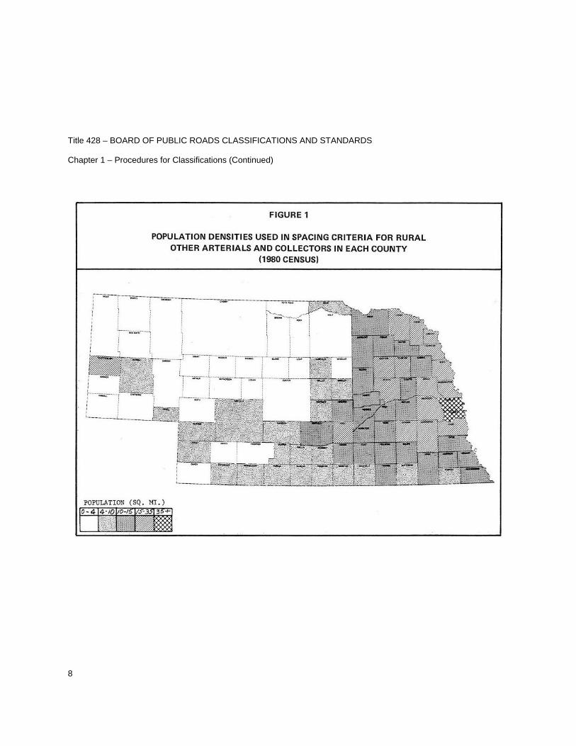
5. Spacing – See Figures 1 and 2.
6. Mileage limitation – See Collector.
001.05 COLLECTOR – shall consist of a group of highways which pick up traffic from many local or land-service roads and carry it to community centers or to the arterial systems. They are the main school bus routes, mail routes, and farm-to-market routes.
SPECIFIC CRITERIA
1. All community centers and agricultural activity centers not on higher systems should be connected with each other and connected with the higher systems by a collector road.
2. Clustered residents who are at considerable distances from the previous selected systems should be served.
3. Spacing should be at intervals, consistent with population density, to collect traffic from local roads and bring all developed areas within a reasonable distance of a collector road. The spacing recommended is shown in Figure 2.
4. The total number of miles in the Other Arterial and Collector Systems shall be limited as shown in Table 1.
5. The location of collector routes should be coordinated at county lines to form an integrated system.
001.06 LOCAL – shall consist of all remaining rural roads, except remote residential and minimum maintenance roads.
SPECIFIC CRITERIA
1. Shall serve, in conjunction with remote residential roads, all occupied residences with connection to another local or higher system classification.
2. Shall serve, in conjunction with remote residential roads, all cemeteries, parks, wildlife management areas or other rural areas with a connection to another local or higher system classification.
3. Shall serve, in conjunction with remote residential roads, all school bus and mail routes not served by a higher system.
4. Shall be so spaced, in conjunction with remote residential roads, as to avoid considerable extra travel or normal travel over minimum maintenance roads.

Title 428 – BOARD OF PUBLIC ROADS CLASSIFICATIONS AND STANDARDS Chapter 1 – Procedures for Classifications (Continued)
5
001.07 REMOTE RESIDENTIAL
GENERAL CRITERIA
General Criteria from Chapter 39, Section 39-2103(9) Nebraska Revised Statutes - shall consist of roads or segments of roads in remote areas of counties with (a) a population density of no more than five people per square mile or (b) an area of at least one thousand square miles, and which roads or segments of roads serve as primary access to no more than seven residences. For the purposes of this subdivision, residence means a structure which serves as a primary residence for more than six months of a calendar year. Population shall be determined using data from the most recent federal decennial census.
SPECIFIC CRITERIA
1. Remote Residential roads shall serve qualified properties having occupied residences with a connection to another remote residential, local or higher system classification. In conjunction with such service, they may also serve as school bus and mail routes and serve farms, ranches, cemeteries, parks, wildlife management areas or other rural areas. For the purpose of this section “qualified” shall pertain to the county population density or area size set forth above.
2. Remote Residential roads shall be sufficient to provide access to properties having remote residences, farms, and ranches by passenger and commercial vehicles. One-lane traffic is allowed where sight distance is adequate to warn motorists of oncoming traffic.
RESTRICTIONS
1. County Board Public Hearing – A County Board Public Hearing is required prior to requesting the department to classify a new road segment or an extension to an existing road segment or to reclassify an existing road segment as a Remote Residential road. For county line roads, each adjoining county shall meet the general criteria of Chapter 39, Section 39-2103(9) Nebraska Revised Statutes and each County Board shall hold a public hearing on the matter prior to requesting the department to classify.
2. Relaxation of Standards – In addition to the County Board Public Hearing, a Relaxation of Standards granted by the Board is required for construction of a new road segment or an extension to an existing road segment, or when a county wants an existing non-surfaced road segment or an existing one-lane road segment with inadequate sight distance reclassified to remote residential. See 428 NAC 2, Section 004.
3. The Functional Classification will only be assigned by the department when requested by official action of a County Board.
Title 428 – BOARD OF PUBLIC ROADS CLASSIFICATIONS AND STANDARDS Chapter 1 – Procedures for Classifications (Continued)
6
001.08 MINIMUM MAINTENANCE – shall consist of roads used occasionally by a limited number of people as alternative access roads for areas served primarily by local, collector, or arterial roads or roads which are the principal access roads to agricultural lands for farm machinery and farm trucks, and which are not primarily used by passenger or commercial vehicles and are not intended for school bus or mail routes.
SPECIFIC CRITERIA
1. Shall provide for travel during normal weather, shall not require snow removal or roadway mowing, except to prevent hazard.
2. Minimum maintenance roads may be earth or turf covered.
3. County line coordination – minimum maintenance roads should not stub at a county line.
4. May not be the only access to an occupied dwelling – a minimum maintenance road shall be reclassified to remote residential, local or a higher functional classification whenever an existing dwelling or newly constructed dwelling becomes occupied.

Title 428 – BOARD OF PUBLIC ROADS CLASSIFICATIONS AND STANDARDS Chapter 1 – Procedures for Classifications (Continued)
7
TABLE 1
PROPOSED ALLOWABLE MILEAGE FUNCTIONAL CLASSIFICATION GROUPS
Rural Systems
%
Miles
Probable Mileage
Interstate plus
Expressway 3 Max. 2,762
482) ) 864
382)
Interstate plus
Expressway plus
Major Arterials
*10,000 Max.
482) )
382) 9,963 )
9,099)
Other Arterials plus
Collector 20 – 25 18,410 – 23,012
10,237) ) 21,374
11,137)
Remaining Local plus
Remote Residential plus Minimum Maintenance
64,798
* The intention of this maximum allowance is to limit the State Highway System to 10,000 miles
(including rural and municipal mileage).
Title 428 – BOARD OF PUBLIC ROADS CLASSIFICATIONS AND STANDARDS Chapter 1 – Procedures for Classifications (Continued)
8

Title 428 – BOARD OF PUBLIC ROADS CLASSIFICATIONS AND STANDARDS Chapter 1 – Procedures for Classifications (Continued)
9

Title 428 – BOARD OF PUBLIC ROADS CLASSIFICATIONS AND STANDARDS Chapter 1 – Procedures for Classifications (Continued)
10
002 SPECIFIC CRITERIA FOR THE FUNCTIONAL CLASSIFICATION OF MUNICIPAL STREETS. Municipal streets shall consist of all public streets within the limits of any incorporated municipality. It is recommended the municipalities be divided into three population groups to facilitate the comparison process which inevitably must take place between cities and villages of similar sizes. These streets shall be divided into six functional classifications groups. Each incorporated municipality with a population over five thousand shall approximate the guideline mileage percentages established in Table 2.
002.01 POPULATION GROUP I – OVER FIFTY THOUSAND (URBANIZED AREAS)
002.01A INTERSTATE – shall consist of the federally-designated National System of Interstate and Defense Highways.
002.01B EXPRESSWAY – which shall consist of two categories: Extension of rural expressways within some urban areas and some additional routes which serve very high volumes of local traffic.
SPECIFIC CRITERIA
1. Provide connecting link for rural expressways which intercept the incorporated municipalities. 2. Provide routes for major traffic generators within the city. 3. Expressway system one in which ultimately should be developed to multi-lane divided
highway standards. 4. Provide an integrated network without stub connections.
002.01C MAJOR ARTERIAL – shall consist of extensions of rural major arterials which provide continuous service through municipalities for long distance rural travel. They are the arterial streets used to transport products into and out of municipalities.
SPECIFIC CRITERIA
1. Connecting link for rural major arterials.
2. Serve the major activity centers of the urban area not served by the higher systems.
3. Serve the highest traffic volume corridors not served by the higher systems.
4. Service to abutting land should not be a primary functional responsibility of this class of street. 5. Serve the longest trip desires not served by the higher systems. 6. Should (in conjunction with the higher systems) carry a high proportion of the total urban area
travel on a minimum of mileage.

Title 428 – BOARD OF PUBLIC ROADS CLASSIFICATIONS AND STANDARDS Chapter 1 – Procedures for Classifications (Continued)
11
7. System should be integrated both internally and between major rural connections. 8. Spacing (in conjunction with the higher systems) may vary from less than one mile in Central
Business District to five miles in urban fringe.
002.01D OTHER ARTERIAL – which shall consist of two categories: municipal extensions of rural other arterials, and arterial movements peculiar to a municipality’s own complex, that is streets which interconnect major areas of activity within a municipality, such as shopping centers, the Central Business District, manufacturing centers, and industrial parks.
SPECIFIC CRITERIA
1. Provide connecting link for rural other arterials. 2. Intra-community connections of areas of activities in municipalities not connected by a higher
order system, such as shopping centers, central business district, manufacturing and industrial areas.
3. Interconnect with and augment the urban major arterial system. This need not form an
integrated system in all cases. 4. Spacing may vary from one-eighth to one-half mile in the Central Business District to two to
three miles in the suburban fringe, but should normally be not more than one mile in fully developed areas.
002.01E COLLECTOR – shall consist of a group of streets which collect traffic from residential streets and move it to smaller commercial centers or to higher arterial systems.
SPECIFIC CRITERIA
1. Collect traffic from local streets in neighborhood and channels it to the arterial system.
2. Provide land access service within residential neighborhoods, commercial areas and
industrial areas.
3. Spacing should be at intervals consistent with population density.
002.01F LOCAL – shall consist of the balance of streets in each municipality, principally residential access service streets and local business streets. They are characterized by very short trip lengths, almost exclusively limited to vehicles desiring to go to or from adjacent property.

Title 428 – BOARD OF PUBLIC ROADS CLASSIFICATIONS AND STANDARDS Chapter 1 – Procedures for Classifications (Continued)
12
002.02 POPULATION GROUP II – FIVE THOUSAND TO FORTY-NINE THOUSAND (SMALL URBAN AREAS)
002.02A INTERSTATE – None
002.02B EXPRESSWAY – Due to present design plans, most cities in this population group will be by-passed with expressways or arterials outside the corporate limits.
002.02C MAJOR ARTERIAL – OTHER ARTERIAL – COLLECTOR – LOCAL – Same specific criteria as for those in Population Group I.
002.03 POPULATION GROUP III – ONE TO FIVE THOUSAND (VILLAGES AND SECOND CLASS CITIES). In the National Highway Functional Classification Study the mileage in cities of less than five thousand population was classified as rural. The specific criteria for small urban areas is generally applicable to these smaller cities and villages. The basic difference is that, by nature of their size, small municipalities will not generate internal travel warranting a network of arterial service.
002.03A INTERSTATE – None
002.03B EXPRESSWAY – None
002.03C MAJOR ARTERIAL – Extension of all major rural arterials into and through these municipalities which are on the State Highway System including stubs and spurs to towns above one hundred population.
002.03D OTHER ARTERIAL – Municipal extension of high volume rural collectors on county system.
002.03E COLLECTOR – Municipal extension of low volume collectors on county system.
002.03F LOCAL – All streets not on one of the higher systems.

Title 428 – BOARD OF PUBLIC ROADS CLASSIFICATIONS AND STANDARDS Chapter 1 – Procedures for Classifications (Continued)
13
TABLE 2
PROPOSED ALLOWABLE MILEAGE FUNCTIONAL CLASSIFICATION GROUPS
Municipal System (Population 5000 and over)
Percent of Mileage In each City
Interstate, Expressway and Major Arterial System Total of Interstate, Expressway, Major Arterial & Other Arterial Systems Collector Streets Local Streets
5 - 10
15 - 25
5 - 10
65 - 80

Title 428 – BOARD OF PUBLIC ROADS CLASSIFICATIONS AND STANDARDS Chapter 1 – Procedures for Classifications (Continued)
14
003 SPECIFIC CRITERIA FOR THE FUNCTIONAL CLASSIFICATION OF SCENIC - RECREATION ROADS.
003.01 Scenic-Recreation, which shall consist of highways or roads located within or which provide access to or through state parks, recreation or wilderness areas, other areas of geographical, historical, geological, recreational, biological, or archaeological significance, or areas of scenic beauty; and are defined as follows:
1. State Parks as defined by 81-815.22 Neb. Rev. Stat. shall mean parks of substantial area with primary value of significant statewide scenic, scientific or historical interest, having a complete development potential and, where possible, a representative portion which can be retained in a natural or relatively undisturbed state.
2. State Recreation or Wilderness Areas as defined by 81-815.22 Neb. Rev. Stat. shall mean areas with a primary value for day use, but with secondary overnight-use facilities or potential, which have reasonable expansion capability and are located in accordance with sound park management principles.
3. Geographic Areas shall consist of a unique or unusual area which has particular interest and is not usually present in extensive numbers in the immediate area.
4. Historical Areas shall include areas which have been determined by the State Historical Society to be historic sites or have been registered or nominated to be included in the National Register of Historic Places.
5. Geological Areas shall consist of unique or unusual areas which have particular interest in the interpretation of geologic information and are the best areas of information in that particular region.
6. Recreational Areas as defined in 81-815.22 Neb. Rev. Stat. State wayside areas shall be areas appropriate in size and located at strategic intervals adjacent to main travelled highways to provide safe rest and picnic stops for travelers, which sites shall be selected for scenic or historical interest, when possible. Equipped with safe approach and departure lanes, and be developed in a manner and with such facilities as are appropriate to their purpose and State Special Use areas shall be those areas which are primarily of public hunting, fishing, or other wildlife values, and which cannot logically be classified in one of the categories listed in sub-divisions 2, 3, 4 or 5 of this section, when so designated by the Nebraska Game and Parks Commission to be maintained from fish and game funds.
7. Biological Significance areas are defined as only those areas where a unique or unusual life form or process exists and only that area that is most unusual in the given region of the State.
8. Archaeological Significant areas are areas for which the Nebraska State Historical Society has declared an archaeological significance. A joint agreement exists between the Society and the Department of Roads concerning these areas if a road project proposes to infringe on them.
Title 428 – BOARD OF PUBLIC ROADS CLASSIFICATIONS AND STANDARDS Chapter 1 – Procedures for Classifications (Continued)
15
9. Scenic. No precise definition of scenic is possible as stated in the Scenic Highways Narrative dated March 12, 1974, by the Nebraska Game and Parks Commission. “Scenery, as with other forms of beauty, lies in the eyes of the beholder, and an element of subjectivity is bound to be a part of any attempt to develop and apply objective criteria and guideline.”
003.02 Jurisdictional responsibility for all scenic-recreation roads and highways shall remain with the governmental subdivision which had jurisdictional responsibility for such road or highway prior to its change in classification to scenic-recreation.
003.03 Specific Criteria for Scenic-Recreation roads shall be divided into two classes.
1. Highways and roads providing access to or to and through scenic-recreation area.
2. Highways and roads located within scenic-recreation area.
003.03A Specific Criteria – Scenic-Recreation roads providing access to or to and through Scenic-Recreation Area:
003.03A1 Highways functionally classified as Interstate shall not be considered for a scenic-recreation classification.
003.03A2 Highways functionally classified as Expressway shall not be considered for a scenic-recreation classification.
003.03A3 SPECIFIC CRITERIA – SCENIC - RECREATION - MAJOR ARTERIAL
1. Scenic-Recreation-Major Arterial shall consist of state highways which provide access to or to and through scenic-recreation areas and which qualify for a Major Arterial Functional Classification.
2. Limits of a Scenic-Recreation Highway to be classified Scenic-Recreation-Major Arterial shall be determined from logical points of Scenic-Recreation interest. Termini may be from a road with any functional classification.
3. Scenic-Recreation-Major Arterial highways to Scenic-Recreation areas shall meet or exceed applicable minimum standards unless a request for Relaxation of Standards has been granted by the Board of Public Roads Classifications and Standards.
4. Effort shall be made to preserve the natural environment to the extent possible without compromising the safety of those using the facility, at the speed limits that apply.

Title 428 – BOARD OF PUBLIC ROADS CLASSIFICATIONS AND STANDARDS Chapter 1 – Procedures for Classifications (Continued)
16
003.03A4 SPECIFIC CRITERIA – SCENIC - RECREATION - OTHER ARTERIAL
1. Scenic-Recreation-Other Arterial shall consist of roads which provide access to or to and through scenic-recreation areas and which qualify for an Other Arterial Functional Classification.
2. Limits of a Scenic-Recreation Road to be classified Scenic-Recreation-Other Arterial shall be determined from logical points of Scenic-Recreation interest. Termini may be from a road with any functional classification.
3. Scenic-Recreation-Other Arterial roads to Scenic-Recreation areas shall meet or exceed applicable minimum standards unless a request for Relaxation of Standards has been granted by the Board of Public Roads Classifications and Standards.
4. Effort shall be made to preserve the natural environment to the extent possible without compromising the safety of those using the facility at the speed limits that apply.
003.03A5 SPECIFIC CRITERIA – SCENIC - RECREATION - COLLECTOR
1. Scenic-Recreation-Collector shall consist of roads which provide access to or to and through Scenic-Recreation areas and which qualify for a Collector Functional Classification.
2. Limits of a Scenic-Recreation Road to be classified Scenic-Recreation-Collector shall be determined from logical points of Scenic-Recreation interest. Termini may be from a road with any functional classification.
3. Scenic-Recreation-Collector roads to Scenic-Recreation areas shall meet or exceed applicable minimum standards unless a request for Relaxation of Standards has been granted by the Board of Public Roads Classifications and Standards.
4. Effort shall be made to preserve the natural environment to the extent possible without compromising the safety of those using the facility at the speed limits that apply.

Title 428 – BOARD OF PUBLIC ROADS CLASSIFICATIONS AND STANDARDS Chapter 1 – Procedures for Classifications (Continued)
17
003.03A6 SPECIFIC CRITERIA – SCENIC - RECREATION - LOCAL
1. Scenic-Recreation-Local shall consist of roads which provide access to or to and through Scenic-Recreation areas and which qualify for a Local Functional Classification.
2. Limits of a Scenic-Recreation Road to be classified Scenic-Recreation-Local shall be determined from logical points of Scenic-Recreation interest. Termini may be from a road with any functional classification.
3. Scenic-Recreation-Local roads to Scenic-Recreation areas shall meet or exceed applicable minimum standards unless a request for Relaxation of Standards has been granted by the Board of Public Roads Classifications and Standards.
4. Effort shall be made to preserve the natural environment to the extent possible without compromising the safety of those using the facility at the speed limits that apply.
003.03A7 Highways functionally classified as Remote Residential shall not be considered for a Scenic-Recreation classification.
003.03A8 Highways functionally classified as Minimum Maintenance shall not be considered for a Scenic-Recreation classification.
003.03B SPECIFIC CRITERIA – SCENIC - RECREATION - INTERNAL ROADS
1. Those roads located within the Scenic-Recreation area which are not through routes. Scenic-Recreation Internal Roads serve as routes within Scenic-Recreation areas.
2. Jurisdictional responsibility is in accordance with the approved Functional Classification.
3. The location of Scenic-Recreation-Internal roads shall be coordinated with other roads in the area so that both through and scenic-recreational travel is served, unless the route terminates in an area as previously described and is not a through route.

Title 428 – BOARD OF PUBLIC ROADS CLASSIFICATIONS AND STANDARDS Chapter 1 – Procedures for Classifications (Continued)
18
004 FUNCTIONAL CLASSIFICATION ASSIGNMENT APPEAL TO THE BOARD OF PUBLIC ROADS CLASSIFICATIONS AND STANDARDS
004.01 Any County or Municipality may, based on changing traffic patterns or volume, request the Department of Roads to reclassify any segment of highway, road or street. The Department shall review such request and either grant or deny the reclassification in whole or in part. Any County or Municipality dissatisfied with the action taken by the Department under this section, may appeal to the Board of Public Roads Classifications and Standards.
004.02 An appeal of assigned functional classification by any County or Municipality shall be submitted to the Board of Public Roads Classifications and Standards in writing. Appeal documentation shall include:
1. One copy of the Resolution, by the County Board or City Council, appealing the assigned functional classification and specifying the functional classification requested.
2. One copy of a map showing the location of the road or street. Beginning and ending points shall be identified.
3. Evidence that the Department of Roads denied a request for reclassification.
4. Traffic count data to include location of traffic count station(s) and date(s).
004.03 Upon the talking of such an appeal, the Board shall review all information pertaining to the assignment and hold a hearing thereon if deemed advisable. The determination, on whether or not a Public Hearing shall be held, shall be by Roll Call Vote. The Board shall set the time and place of Public Hearing.
004.04 When a functional classification appeal Public Hearing is scheduled by the Board, the Secretary for the Board shall:
1. Notify in writing the County(s) and/or Municipality(s) of the time and place for Public Hearing at least ten days prior to the Hearing.
2. Notify in writing the Director-State Engineer, Department of Roads the time and place for Public Hearing at least ten days prior to the Hearing.
3. Cause to be published a legal notice of Public hearing at least ten days prior thereto in a designated legal newspaper in the County(s) and/or Municipality(s) at least one time stating the time and place and purpose of the Public Hearing. Such legal notice shall also be published in a legal newspaper with statewide circulation.
4. Notify in writing the members of the Board and place the Public Hearing on the Agenda.

Title 428 – BOARD OF PUBLIC ROADS CLASSIFICATIONS AND STANDARDS Chapter 1 – Procedures for Classifications (Continued)
19
5. Prepare the Public Hearing format which will be divided into three parts in addition to the opening and closing statements.
PART ONE. The County(s) and/or Municipality(s) shall present their appeal.
PART TWO. The Department of Roads shall present information concerning the functional classification as assigned.
PART THREE. The Board shall conduct a question and answer period if deemed advisable.
004.05 FUNCTIONAL CLASSIFICATION APPEAL TRANSCRIPTS. All Functional Classification Appeals shall be recorded and a written transcript prepared under the direction of the Secretary for the Board.
Statements or exhibits submitted to the Board within ten days following the Public Hearing will become an official part of the Public Hearing transcript.
One copy of the Public Hearing transcript shall be furnished to each Board member. The Board shall examine the transcript for correctness. The accepted Public Hearing transcript shall then be available for public inspection and copying at the Department of Roads’ Headquarters, South Junction U.S. 77 and N-2, Lincoln, Nebraska.
004.06. Within ninety days of the date of the hearing, the Board will meet, consider the request, and by one vote, grant or deny the appeal either in whole or in part. An affirmative vote of at least six members will be necessary to grant an appeal. A permanent record will be maintained of the Board’s decision. A copy will be distributed to the requesting County(s) or Municipality(s) to the Department of Roads, and to any interested party requesting a record of the proceeding.
The Boards’ decision on the assigned classification shall be subject to the provisions of Chapter 84, Article 9 Neb. Rev. Stat.

20

Last Issue Date: July 17, 2009
NEBRASKA ADMINISTRATIVE CODE Title 428 – BOARD OF PUBLIC ROADS CLASSIFICATIONS AND STANDARDS Chapter 2 – Procedures for Standards
1
Chapter Index Section Minimum Design Standards – State Highway, County Road and Municipal Street Systems (Amended March 25, 2016) ................................................................................ 001
Intent of Board for Interpretation of Design Standards ................................................. 001.01 State Highway System ................................................................................................ 001.02 County Road And Municipal Street Systems ............................................................... 001.03
Minimum Construction Standards – State Highway, County Road and Municipal Street Systems (Amended March 25, 2016) ................................................................................ 002 Minimum Maintenance Standards – State Highway, County Road and Municipal Street Systems (Amended March 25, 2016) ................................................................................ 003 Relaxation of Standards – State Highway, County Road and Municipal Street Systems (Amended March 25, 2016) ................................................................................ 004 Standard Compliance Inspection Procedures – State Highway, County Road and Municipal Street Systems (Amended March 25, 2016) ...................................................... 005

Title 428 – BOARD OF PUBLIC ROADS CLASSIFICATIONS AND STANDARDS Chapter 2 – Procedures for Standards (Continued)
2
001 MINIMUM DESIGN STANDARDS – STATE HIGHWAY, COUNTY ROAD AND MUNICIPAL STREET SYSTEMS
001.01 INTENT OF BOARD FOR INTERPRETATION OF DESIGN STANDARDS
001.01A These standards are minimum standards of design, construction and maintenance for each functional classification of highway, street or road. These standards are not intended to require the reconstruction of highways, roads or streets previously constructed. 001.01B The Board encourages the owners of highways, roads and streets to design their facilities to meet each applicable design standard set out in these rules and regulations. The Board understands that construction of highways, roads and streets cannot be completed with the accuracy that could be implied by these standards. The Board recognizes that current construction methods can only achieve substantial conformance to the design. The Board recognizes further that measurements of highway geometry will also vary as a result of the measurement method used and the inherent discretion required in selecting the beginning and end points of the feature being measured. Further, after construction, a transportation facility is subject to wear and tear related to post-construction human impacts, varying environmental and weather conditions, changes that result from natural processes and lack of available funding. Therefore, a particular roadway may not, after construction, strictly conform to the design standards set out in these rules. Absent bad faith, the Board believes that a post-construction failure to meet standards should not be viewed as improper, as a violation of these standards, or as evidence of negligence, in and of itself. These rules should be interpreted as a failure to meet standards only when there is a clear and convincing showing that the owner disregarded these standards. Therefore, these design standards should not be interpreted as requiring strict compliance at each and every street, road or highway location because such precision was not intended by the Board nor can it ever be obtained. This statement of intent is not intended to limit or affect any remedy available to the Board by law.
Copies of the following documents referred to in the Standards are on file in the NDOR Central Administration Complex, 1500 Highway 2, Lincoln, Nebraska: AASHTO “A Policy on Geometric Design of Highways and Streets 6th Edition 2011”
AASHTO “Guidelines for Geometric Design of Very Low-Volume Local Roads (ADT ≤ 400) Edition 2001”
AASHTO “Roadside Design Guide 4th Edition 2011”
Mitigation Strategies for Design Exceptions, U.S. Dept. Of Transportation, FHWA, Washington, D.C., 2007

Title 428 – BOARD OF PUBLIC ROADS CLASSIFICATIONS AND STANDARDS Chapter 2 – Procedures for Standards (Continued)
3
Special Report 214, Designing Safer Roads, Practices for Resurfacing, Restoration, and Rehabilitation, Transportation Research Board, National Research Council
NDOR, Nebraska Department of Roads, 2007 Standard Specifications for Highway Construction
Manual on Uniform Traffic Control Devices for Streets and Highways (MUTCD) adopted pursuant to Chapter 60, Neb. Rev. Stat. §60-6,118 The following abbreviations and symbols are used in the Standards:
% Percent
%HT heavy trucks as a percentage of all traffic
+ Plus
< Less than (fewer than)
= Equal to
> Greater than (more than)
≤ Equal to or less than (equal to or fewer than)
≥ Equal to or greater than (equal to or more than)
3R Resurfacing, Restoration and Rehabilitation
AASHTO American Association of State Highway and Transportation Officials
ADT average daily traffic (volume)
Board Nebraska Board of Public Roads Classifications and Standards
BOC Back-of-curb
DDHV Directional Design Hourly Volume
DHV Design Hourly Volume
DS design speed
emax maximum superelevation
EOTW edge of traveled way
ft. foot or feet
GVW Gross Vehicle Weight
H Horizontal (used in slopes, e.g. 1V:4H)
HL93 AASHTO Load and Resistance Factor Design (LRFD) Bridge Design Specification
HS15 Standard vehicle live loads (15-ton GVW, 3 tons applied to front axle, 12 tons to rear axle) established by AASHTO for use in bridge design and rating.
HS20 Standard vehicle live loads (36-ton GVW, 4 tons applied to front axle, 16 tons to rear axle, 16 tons to semi-trailer axle) established by AASHTO for use in bridge design and rating.
Lt. left

Title 428 – BOARD OF PUBLIC ROADS CLASSIFICATIONS AND STANDARDS Chapter 2 – Procedures for Standards (Continued)
4
MPH miles per hour (speed)
NBCS Nebraska Board of Public Roads Classifications and Standards
NDOR Nebraska Department of Roads
RSAP Roadside Safety Analysis Program
Rt. right
V Vertical (used in slopes, e.g. 1V:4H)
VPD vehicles per day
Title 428 – BOARD OF PUBLIC ROADS CLASSIFICATIONS AND STANDARDS Chapter 2 – Procedures for Standards (Continued)
5
001.02 STATE HIGHWAY SYSTEM Index Section Section Table of Contents: State Functional Classification [National Functional Classification] Table of Notes – State Highway System ................................................................... 001.02A Table of Definitions – State Highway System ............................................................ 001.02B NEW AND RECONSTRUCTED RURAL – STATE HIGHWAY SYSTEM
Interstate [Interstate] ............................................................................................ 001.02C Expressway (Access Only at Interchanges) [Other Freeways and Expressways] 001.02D Expressway [Other Freeways and Expressways] ................................................ 001.02E Major Arterial [Other Principal Arterials or Minor Arterial] ...................................... 001.02F Major Arterial [Major Collector, Minor Collector or Local] ..................................... 001.02G Scenic-Recreation-Major Arterial [Other Principal Arterials, Minor Arterial, Major Collector or Minor Collector] ...................................................................... 001.02H
NEW AND RECONSTRUCTED MUNICIPAL – STATE HIGHWAY SYSTEM
Interstate [Interstate] .............................................................................................. 001.02I Expressway (Access Only at Interchanges) [Other Freeways and Expressways] . 001.02J Expressway [Other Freeways and Expressways] ................................................ 001.02K Major Arterial [Other Principal Arterials or Minor Arterial] ...................................... 001.02L Major Arterial [Major Collector or Minor Collector] ............................................... 001.02M

Title 428 – BOARD OF PUBLIC ROADS CLASSIFICATIONS AND STANDARDS Chapter 2 – Procedures for Standards (Continued)
6
RESURFACING, RESTORATION AND REHABILITATION (3R) RURAL – STATE HIGHWAY SYSTEM
Interstate [Interstate] ............................................................................................ 001.02N Expressway (Access Only at Interchanges) [Other Freeways and Expressways] 001.02O Expressway [Other Freeways and Expressways] ................................................ 001.02P Major Arterial [Other Principal Arterials or Minor Arterial] ..................................... 001.02Q Major Arterial [Major Collector, Minor Collector or Local]. .................................... 001.02R Scenic-Recreation-Major Arterial [Other Principal Arterials, Minor Arterial, Major Collector or Minor Collector] ...................................................................... 001.02S
RESURFACING, RESTORATION AND REHABILITATION (3R) MUNICIPAL – STATE HIGHWAY SYSTEM
Interstate [Interstate] ............................................................................................. 001.02T Expressway (Access Only at Interchanges) [Other Freeways and Expressways] 001.02U Expressway [Other Freeways and Expressways] ................................................ 001.02V Major Arterial [Other Principal Arterials or Minor Arterial] .................................... 001.02W Major Arterial [Major Collector or Minor Collector] ............................................... 001.02X

Title 428 – BOARD OF PUBLIC ROADS CLASSIFICATIONS AND STANDARDS Chapter 2 – Procedures for Standards (Continued)
7
001.02A TABLE OF NOTES – STATE HIGHWAY SYSTEM
(1) The design speed shall at least be equal to the anticipated posted speed limit.
(2) DDHV and ADT are based on the project design year.
(3)
This area, measured from the edge of the through travel lane, shall have 1:6 side slopes or flatter which may have crashworthy or break-away obstacles and shall be free of non-shielded obstacles except:
1. Traffic signal poles, railroad signals, railroad tracks, bridge rails, ditches, driveways, intersections, bike/pedestrian paths, earth dikes, curbs, raised islands, guardrails, median barriers, crash cushions, drainage inlets, drainage flumes, culverts with flared end sections, erosion control devices, fire hydrants, and traffic control devices;
2. Other obstacles if the NDOR, in its sole discretion, determines based upon an accident review and a Roadside Safety Analysis Program (RSAP) review or a comparable AASHTO approved economic analysis, that the cost to remove or treat such obstacle exceeds the benefits from such removal or treatment.
Outside of the horizontal clear zone it is expressly understood that the following non-exclusive list of items may be present within the roadside environment:
Traffic signal poles, railroad signals, railroad tracks, bridge rails, ditches, driveways, intersections, bike/pedestrian paths, earth dikes, curbs, raised islands, guardrails, median barriers, crash cushions, drainage inlets, drainage flumes, culverts with flared end sections, erosion control devices, fire hydrants, traffic control devices, trash cans, parking meters/facilities, handrails, concrete barrier, barrier curb, trash receptacles, drainage facilities, wetlands, bodies of water, culverts, culvert end sections, culvert headwalls, utility facilities, trees, vegetation, mailboxes, and critical and non-recoverable slopes.

Title 428 – BOARD OF PUBLIC ROADS CLASSIFICATIONS AND STANDARDS Chapter 2 – Procedures for Standards (Continued)
8
(4)
This area, measured from the edge of the through travel lane, shall have 1:6 side slopes or flatter which may have crashworthy or break-away obstacles and shall be free of non-shielded obstacles except:
1. Traffic signal poles, railroad signals, railroad tracks, bridge rails, ditches, driveways, intersections, bike/pedestrian paths, earth dikes, curbs, raised islands, guardrails, median barriers, crash cushions, drainage inlets, drainage flumes, culverts with flared end sections, erosion control devices, trash cans, parking meters/facilities, fire hydrants, handrails, concrete barrier, barrier curb, and traffic control devices;
2. Other obstacles if the NDOR, in its sole discretion, determines based upon
an accident review and a Roadside Safety Analysis Program (RSAP) review or a comparable AASHTO approved economic analysis, that the cost to remove or treat such obstacle exceeds the benefits from such removal or treatment.
Outside of the horizontal clear zone it is expressly understood that the following non-exclusive list of items may be present within the roadside environment:
Traffic signal poles, railroad signals, railroad tracks, bridge rails, ditches, driveways, intersections, bike/pedestrian paths, earth dikes, curbs, raised islands, guardrails, median barriers, crash cushions, drainage inlets, drainage flumes, culverts with flared end sections, erosion control devices, fire hydrants, traffic control devices, trash cans, parking meters/facilities, handrails, concrete barrier, barrier curb, trash receptacles, drainage facilities, wetlands, bodies of water, culverts, culvert end sections, culvert headwalls, utility facilities, trees, vegetation, mailboxes, and critical and non-recoverable slopes.
Title 428 – BOARD OF PUBLIC ROADS CLASSIFICATIONS AND STANDARDS Chapter 2 – Procedures for Standards (Continued)
9
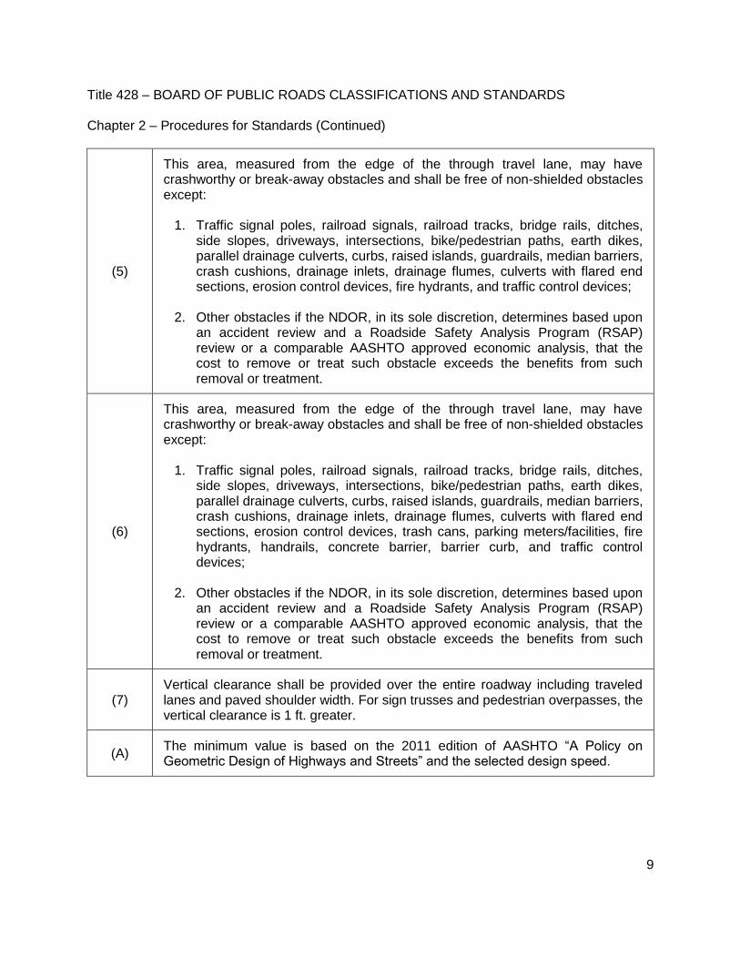
(5)
This area, measured from the edge of the through travel lane, may have crashworthy or break-away obstacles and shall be free of non-shielded obstacles except:
1. Traffic signal poles, railroad signals, railroad tracks, bridge rails, ditches, side slopes, driveways, intersections, bike/pedestrian paths, earth dikes, parallel drainage culverts, curbs, raised islands, guardrails, median barriers, crash cushions, drainage inlets, drainage flumes, culverts with flared end sections, erosion control devices, fire hydrants, and traffic control devices;
2. Other obstacles if the NDOR, in its sole discretion, determines based upon
an accident review and a Roadside Safety Analysis Program (RSAP) review or a comparable AASHTO approved economic analysis, that the cost to remove or treat such obstacle exceeds the benefits from such removal or treatment.
(6)
This area, measured from the edge of the through travel lane, may have crashworthy or break-away obstacles and shall be free of non-shielded obstacles except:
1. Traffic signal poles, railroad signals, railroad tracks, bridge rails, ditches, side slopes, driveways, intersections, bike/pedestrian paths, earth dikes, parallel drainage culverts, curbs, raised islands, guardrails, median barriers, crash cushions, drainage inlets, drainage flumes, culverts with flared end sections, erosion control devices, trash cans, parking meters/facilities, fire hydrants, handrails, concrete barrier, barrier curb, and traffic control devices;
2. Other obstacles if the NDOR, in its sole discretion, determines based upon
an accident review and a Roadside Safety Analysis Program (RSAP) review or a comparable AASHTO approved economic analysis, that the cost to remove or treat such obstacle exceeds the benefits from such removal or treatment.
(7) Vertical clearance shall be provided over the entire roadway including traveled lanes and paved shoulder width. For sign trusses and pedestrian overpasses, the vertical clearance is 1 ft. greater.
(A) The minimum value is based on the 2011 edition of AASHTO “A Policy on Geometric Design of Highways and Streets” and the selected design speed.

Title 428 – BOARD OF PUBLIC ROADS CLASSIFICATIONS AND STANDARDS Chapter 2 – Procedures for Standards (Continued)
10
(B) The surfaced shoulder slope should not be less than the slope of the adjacent lane.
(C) The clear bridge width shall be at least the width of the paved approach lanes and the nominal paved shoulders.
(D) On roadways where there are more than two lanes inclined in the same direction, the cross slope may be increased by 0.5% to 1% for each additional lane, up to a maximum of 3%.
(E) A 2 ft. turf shoulder adjacent to a paved surface may be at the same slope as the paved surface.
(F) The Design Loading used shall be the original design loading or, if unknown, use HS20.
(G) The clear bridge width shall be 1 ft. wider than the gutter line width of the approach roadway. The gutter line is defined as being 1 ft. inside the back of the roadway curb.
(H)
The maximum grade for rolling terrain may be two percent steeper for tangent lengths less than 500 ft. and one-way downgrades. For extreme cases, at some underpass and bridge approaches, steeper grades for relatively short lengths may be used.
(I) AASHTO standards in effect at time of most recent New and Reconstruction project on the section of the Interstate.
(J) If a 4-lane divided facility exists, the minimum inside shoulder width is 3 ft. paved and the minimum outside shoulder is 8 ft. paved.
(K)
The allowable speed for the available stopping sight distance as computed from the 2011 edition of AASHTO “A Policy on Geometric Design of Highways and Streets” shall not be less than the stopping sight distance computed for a speed 20 MPH below the posted speed limit in a crest vertical curve or less than the stopping sight distance computed for a speed 25 MPH below the posted speed limit in a sag vertical curve.

Title 428 – BOARD OF PUBLIC ROADS CLASSIFICATIONS AND STANDARDS Chapter 2 – Procedures for Standards (Continued)
11
(L)
The allowable speed for the available stopping sight distance as computed from the 2011 edition of AASHTO “A Policy on Geometric Design of Highways and Streets” in a crest vertical curve shall not be less than the stopping sight distance computed for a speed 20 MPH below the posted speed limit. The existing conditions in a sag vertical curve will be allowed.
(M) The minimum clear bridge width shall be adjusted upwards for any changes in lane width and/or nominal paved shoulder width.
(N) For rehabilitated bridges it is desirable to use the new and reconstructed clear bridge width.
(O) The face of the curb is defined as being 1 ft. inside the back of the roadway curb.
(P) The “nominal shoulder width” is defined as the shoulder width presented in this table.
(R) 6 ft. measured from the edge of the through travel lane or 2 ft. measured from the back of the curb, whichever is the greater distance from the edge of the through travel lane.
(S) Use the applicable New and Reconstructed Rural – State Highway System design standards.
(T) Use the applicable Resurfacing, Restoration and Rehabilitation (3R) Rural – State Highway System design standards.
# Municipal – State Highway System design standards may be used in residential and commercial areas lying outside municipal boundaries when the anticipated posted speed limit is less than or equal to 45 MPH.
When the anticipated posted speed limit is greater than or equal to 50 MPH, use the 001.02E New and Reconstructed Rural – State Highway System Table.
When the anticipated posted speed limit is greater than or equal to 50 MPH, use the 001.02F New and Reconstructed Rural – State Highway System Table.
When the anticipated posted speed limit is greater than or equal to 50 MPH, use the 001.02G New and Reconstructed Rural – State Highway System Table.
When the anticipated posted speed limit is greater than or equal to 50 MPH, use the 001.02P Resurfacing, Restoration and Rehabilitation (3R) Rural – State Highway System Table.
Title 428 – BOARD OF PUBLIC ROADS CLASSIFICATIONS AND STANDARDS Chapter 2 – Procedures for Standards (Continued)
12
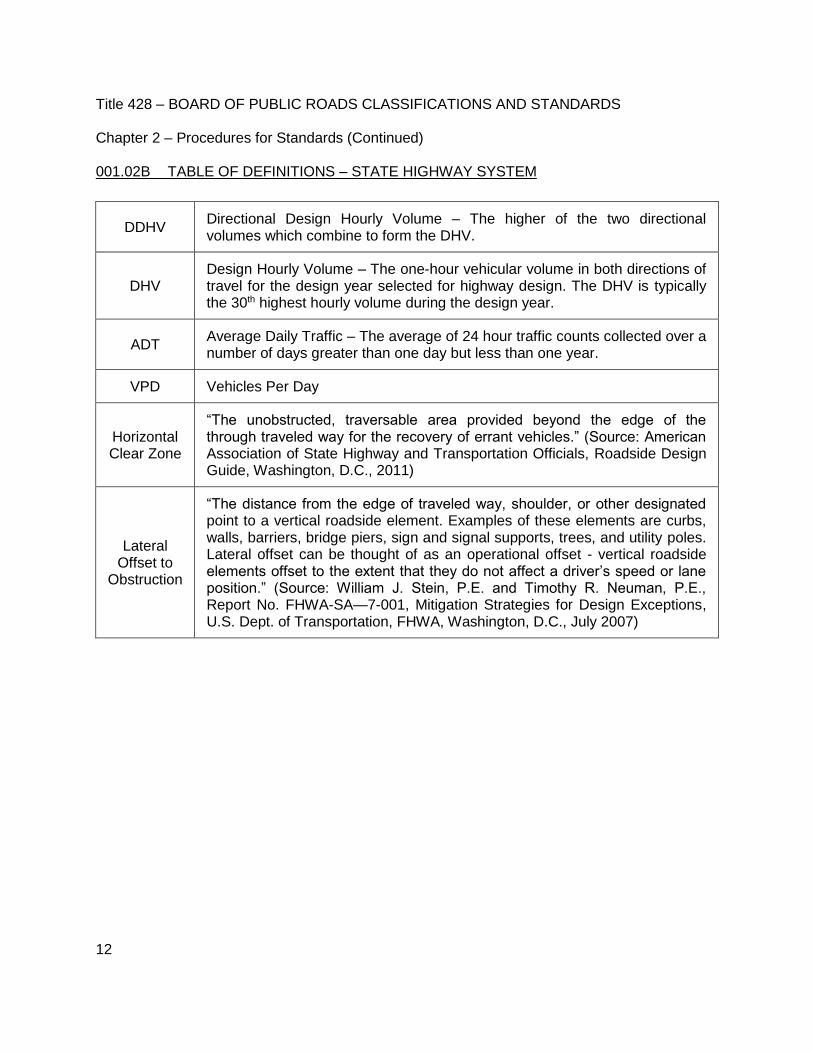
001.02B TABLE OF DEFINITIONS – STATE HIGHWAY SYSTEM
DDHV Directional Design Hourly Volume – The higher of the two directional volumes which combine to form the DHV.
DHV Design Hourly Volume – The one-hour vehicular volume in both directions of travel for the design year selected for highway design. The DHV is typically the 30th highest hourly volume during the design year.
ADT Average Daily Traffic – The average of 24 hour traffic counts collected over a number of days greater than one day but less than one year.
VPD Vehicles Per Day
Horizontal Clear Zone
“The unobstructed, traversable area provided beyond the edge of the through traveled way for the recovery of errant vehicles.” (Source: American Association of State Highway and Transportation Officials, Roadside Design Guide, Washington, D.C., 2011)
Lateral Offset to
Obstruction
“The distance from the edge of traveled way, shoulder, or other designated point to a vertical roadside element. Examples of these elements are curbs, walls, barriers, bridge piers, sign and signal supports, trees, and utility poles. Lateral offset can be thought of as an operational offset - vertical roadside elements offset to the extent that they do not affect a driver’s speed or lane position.” (Source: William J. Stein, P.E. and Timothy R. Neuman, P.E., Report No. FHWA-SA—7-001, Mitigation Strategies for Design Exceptions, U.S. Dept. of Transportation, FHWA, Washington, D.C., July 2007)
Title 428 – BOARD OF PUBLIC ROADS CLASSIFICATIONS AND STANDARDS Chapter 2 – Procedures for Standards (Continued)
13
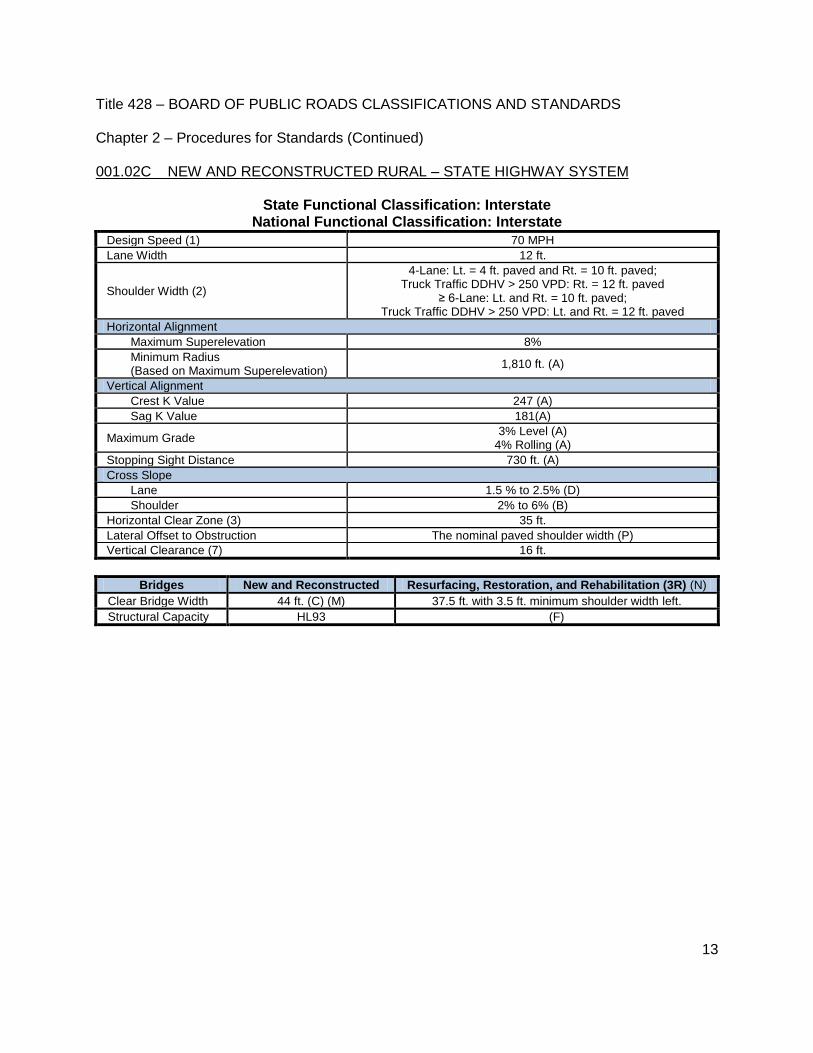
001.02C NEW AND RECONSTRUCTED RURAL – STATE HIGHWAY SYSTEM
State Functional Classification: Interstate National Functional Classification: Interstate
Design Speed (1) 70 MPH
Lane Width 12 ft.
Shoulder Width (2)
4-Lane: Lt. = 4 ft. paved and Rt. = 10 ft. paved; Truck Traffic DDHV > 250 VPD: Rt. = 12 ft. paved
≥ 6-Lane: Lt. and Rt. = 10 ft. paved; Truck Traffic DDHV > 250 VPD: Lt. and Rt. = 12 ft. paved
Horizontal Alignment
Maximum Superelevation 8%
Minimum Radius (Based on Maximum Superelevation)
1,810 ft. (A)
Vertical Alignment
Crest K Value 247 (A)
Sag K Value 181(A)
Maximum Grade 3% Level (A)
4% Rolling (A)
Stopping Sight Distance 730 ft. (A)
Cross Slope
Lane 1.5 % to 2.5% (D)
Shoulder 2% to 6% (B)
Horizontal Clear Zone (3) 35 ft.
Lateral Offset to Obstruction The nominal paved shoulder width (P)
Vertical Clearance (7) 16 ft.
Bridges New and Reconstructed Resurfacing, Restoration, and Rehabilitation (3R) (N)
Clear Bridge Width 44 ft. (C) (M) 37.5 ft. with 3.5 ft. minimum shoulder width left.
Structural Capacity HL93 (F)

Title 428 – BOARD OF PUBLIC ROADS CLASSIFICATIONS AND STANDARDS Chapter 2 – Procedures for Standards (Continued)
14
001.02D NEW AND RECONSTRUCTED RURAL – STATE HIGHWAY SYSTEM
State Functional Classification: Expressway (Access Only At Interchanges) National Functional Classification: Other Freeways and Expressways
Design Speed (1) 55 MPH
Lane Width 12 ft.
Shoulder Width (2)
4-Lane: Lt. = 4 ft. paved and Rt. = 10 ft. paved; Truck Traffic DDHV > 250 VPD: Rt. = 12 ft. paved
≥ 6-Lane: Lt. and Rt. = 10 ft. paved; Truck Traffic DDHV > 250 VPD: Lt. and Rt. = 12 ft. paved
Horizontal Alignment
Maximum Superelevation 8%
Minimum Radius (Based on Maximum Superelevation)
960 ft. (A)
Vertical Alignment
Crest K Value 114 (A)
Sag K Value 115 (A)
Maximum Grade 3% Level (A)
4% Rolling (A)
Stopping Sight Distance 495 ft. (A)
Cross Slope
Lane 1.5% to 2% (D)
Shoulder 2% to 6% (B)
Horizontal Clear Zone (3) 30 ft.
Lateral Offset to Obstruction The nominal shoulder width (P)
Vertical Clearance (7) 16 ft.
Bridges New and Reconstructed Resurfacing, Restoration, and Rehabilitation (3R)
Clear Bridge Width 42 ft. (C) (M) Not Applicable
Structural Capacity HL93 Not Applicable

Title 428 – BOARD OF PUBLIC ROADS CLASSIFICATIONS AND STANDARDS Chapter 2 – Procedures for Standards (Continued)
15
001.02E NEW AND RECONSTRUCTED RURAL – STATE HIGHWAY SYSTEM
State Functional Classification: Expressway # National Functional Classification: Other Freeways and Expressways
Design Speed (1) 55 MPH
Lane Width 12 ft.
Shoulder Width Lt. = 4 ft. paved and Rt. = 8 ft. paved
≥ 6-Lane: Lt. = 8 ft. paved
Horizontal Alignment
Maximum Superelevation 8%
Minimum Radius (Based on Maximum Superelevation)
960 ft. (A)
Vertical Alignment
Crest K Value 114 (A)
Sag K Value 115 (A)
Maximum Grade 4% Level (A)
5% Rolling (A) (May be up to 1% steeper for tangent lengths < 500 ft.)
Stopping Sight Distance 495 ft. (A)
Cross Slope
Lane 1.5% to 2% (D)
Shoulder 2% to 6% paved (B)
6% to 8% turf (E)
Horizontal Clear Zone (3) 30 ft.
Lateral Offset to Obstruction The nominal shoulder width (P)
Vertical Clearance (7) 16 ft.
Bridges New and Reconstructed Resurfacing, Restoration, and Rehabilitation (3R) (N)
Clear Bridge Width 40 ft. (C) (M) 35 ft. (4-lane with twin bridges) 30 ft. (2-lane with single bridge)
Structural Capacity HL93 (F)

Title 428 – BOARD OF PUBLIC ROADS CLASSIFICATIONS AND STANDARDS Chapter 2 – Procedures for Standards (Continued)
16
001.02F NEW AND RECONSTRUCTED RURAL – STATE HIGHWAY SYSTEM
State Functional Classification: Major Arterial # National Functional Classification: Other Principal Arterials or Minor Arterial
Design Speed (1) 50 MPH
Lane Width 12 ft.
Shoulder Width (2)
ADT ≥ 4,000 VPD: 8 ft. paved
ADT 2,000 - 3,999 VPD: 8 ft. total with 2 ft. paved
ADT 400 - 1,999 VPD: 6 ft.
ADT < 400 VPD: 4 ft.
Horizontal Alignment
Maximum Superelevation 8%
Minimum Radius (Based on Maximum Superelevation)
758 ft. (A)
Vertical Alignment
Crest K Value 84 (A)
Sag K Value 96 (A)
Maximum Grade 4% Level (A)
5% Rolling (A) (May be up to 1% steeper for tangent lengths < 500 ft.)
Stopping Sight Distance 425 ft. (A)
Cross Slope
Lane 1.5% to 2% (D)
Shoulder 2% to 6% paved (B)
6% to 8% turf (E) 4% to 6% aggregate
Horizontal Clear Zone (2) (3) ADT ≥ 2,000 VPD: 30 ft.
ADT 400 - 1,999 VPD: 23 ft. ADT < 400 VPD: 16 ft.
Lateral Offset to Obstruction The nominal shoulder width (P)
Vertical Clearance (7) 16 ft.
Bridges New and Reconstructed Resurfacing, Restoration, and Rehabilitation
(3R) (N)
Clear Bridge Width (2)
ADT ≥ 4,000 VPD: 44 ft. (C) (M) ADT ≥ 4,000 VPD: 30 ft.
ADT 2,000 - 3,999 VPD: 40 ft. (M)
ADT < 4,000 VPD: 28 ft. ADT 400 - 1,999 VPD: 36 ft. (M)
ADT < 400 VPD: 32 ft. (M)
Structural Capacity HL93 (F)

Title 428 – BOARD OF PUBLIC ROADS CLASSIFICATIONS AND STANDARDS Chapter 2 – Procedures for Standards (Continued)
17
001.02G NEW AND RECONSTRUCTED RURAL – STATE HIGHWAY SYSTEM
State Functional Classification: Major Arterial # National Functional Classification: Major Collector, Minor Collector or Local
Design Speed (1) 50 MPH
Lane Width 12 ft.
Shoulder Width (2)
ADT ≥ 4,000 VPD: 8 ft. paved ADT 2,000 - 3,999 VPD: 8 ft. total with 2 ft. paved
ADT 400 - 1,999 VPD: 6 ft. ADT < 400 VPD: 4 ft.
Horizontal Alignment
Maximum Superelevation 8%
Minimum Radius (Based on Maximum Superelevation)
758 ft. (A)
Vertical Alignment
Crest K Value 84 (A)
Sag K Value 96 (A)
Maximum Grade 6% Level (A)
7% Rolling (A) (May be up to 2% steeper for tangent lengths < 500 ft.)
Stopping Sight Distance 425 ft. (A)
Cross Slope
Lane 1.5% to 2% paved surfaces
2% to 4% aggregate surfaces
Shoulder 2% to 6% paved (B)
6% to 8% turf (E) 4% to 6% aggregate
Horizontal Clear Zone (2) (3) ADT ≥ 2,000 VPD: 30 ft.
ADT 400 - 1,999 VPD: 23 ft. ADT < 400 VPD: 16 ft.
Lateral Offset to Obstruction The nominal shoulder width (P)
Vertical Clearance (7) 16 ft.
Bridges New and Reconstructed Resurfacing, Restoration, and Rehabilitation
(3R) (N)
Clear Bridge Width (2)
ADT ≥ 4,000 VPD: 44 ft. (C) (M) ADT ≥ 4,000 VPD: 30 ft.
ADT 2,000 - 3,999 VPD: 40 ft. (M) ADT 2,000 - 3,999 VPD: 28 ft.
ADT 400 - 1,999 VPD: 36 ft. (M) ADT 400 - 1,999 VPD: 26 ft.
ADT< 400 VPD: 32 ft. (M) ADT< 400 VPD: 24 ft.
Structural Capacity HL93 (F)
Title 428 – BOARD OF PUBLIC ROADS CLASSIFICATIONS AND STANDARDS Chapter 2 – Procedures for Standards (Continued)
18
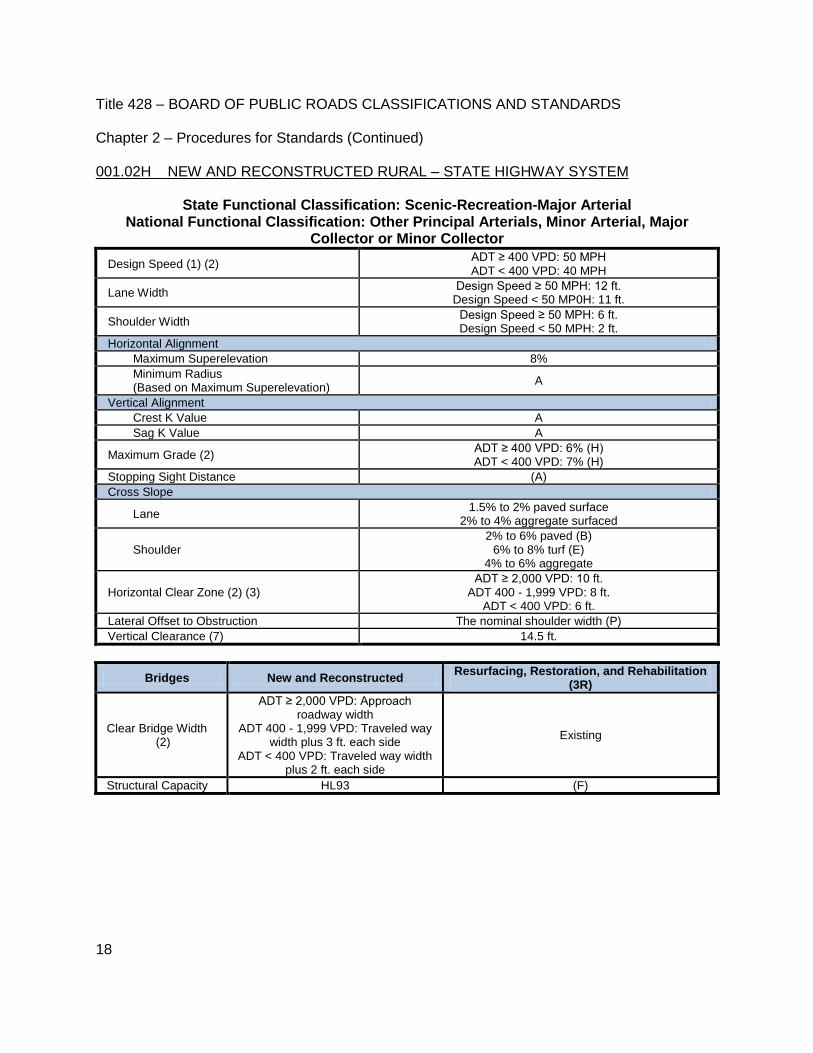
001.02H NEW AND RECONSTRUCTED RURAL – STATE HIGHWAY SYSTEM
State Functional Classification: Scenic-Recreation-Major Arterial National Functional Classification: Other Principal Arterials, Minor Arterial, Major
Collector or Minor Collector
Design Speed (1) (2) ADT ≥ 400 VPD: 50 MPH ADT < 400 VPD: 40 MPH
Lane Width Design Speed ≥ 50 MPH: 12 ft.
Design Speed < 50 MP0H: 11 ft.
Shoulder Width Design Speed ≥ 50 MPH: 6 ft. Design Speed < 50 MPH: 2 ft.
Horizontal Alignment
Maximum Superelevation 8%
Minimum Radius (Based on Maximum Superelevation)
A
Vertical Alignment
Crest K Value A
Sag K Value A
Maximum Grade (2) ADT ≥ 400 VPD: 6% (H) ADT < 400 VPD: 7% (H)
Stopping Sight Distance (A)
Cross Slope
Lane 1.5% to 2% paved surface
2% to 4% aggregate surfaced
Shoulder 2% to 6% paved (B)
6% to 8% turf (E) 4% to 6% aggregate
Horizontal Clear Zone (2) (3) ADT ≥ 2,000 VPD: 10 ft.
ADT 400 - 1,999 VPD: 8 ft. ADT < 400 VPD: 6 ft.
Lateral Offset to Obstruction The nominal shoulder width (P)
Vertical Clearance (7) 14.5 ft.
Bridges New and Reconstructed Resurfacing, Restoration, and Rehabilitation
(3R)
Clear Bridge Width (2)
ADT ≥ 2,000 VPD: Approach roadway width
ADT 400 - 1,999 VPD: Traveled way width plus 3 ft. each side
ADT < 400 VPD: Traveled way width plus 2 ft. each side
Existing
Structural Capacity HL93 (F)

Title 428 – BOARD OF PUBLIC ROADS CLASSIFICATIONS AND STANDARDS Chapter 2 – Procedures for Standards (Continued)
19
001.02I NEW AND RECONSTRUCTED MUNICIPAL – STATE HIGHWAY SYSTEM
State Functional Classification: Interstate National Functional Classification: Interstate
Design Speed (1) 50 MPH
Lane Width 12 ft.
Shoulder Width (2)
4 Lane: Lt. = 4 ft. paved and Rt. = 10 ft. paved; Truck Traffic DDHV > 250 VPD: Rt. = 12 ft. paved
≥ 6-Lane: Lt. and Rt. = 10 ft. paved; Truck Traffic DDHV > 250 VPD: Lt. and Rt. = 12 ft. paved
Horizontal Alignment
Maximum Superelevation 8%
Minimum Radius (Based on Maximum Superelevation)
758 ft. (A)
Vertical Alignment
Crest K Value 84 (A)
Sag K Value 96 (A)
Maximum Grade 4% Level (A)
5% Rolling (A) (May be 1% steeper for tangent lengths < 500 ft.)
Stopping Sight Distance 425 ft. (A)
Cross Slope
Lane 1.5% to 2.5% (D)
Shoulder 2% to 6% (B)
Horizontal Clear Zone (4) 30 ft.
Lateral Offset to Obstruction The nominal paved shoulder width (P)
Vertical Clearance (7) 16 ft.
Bridges New and Reconstructed Resurfacing, Restoration, and Rehabilitation (3R) (N)
Clear Bridge Width 44 ft. (C) (M) 37.5 ft. with 3.5 ft. minimum shoulder width left.
Structural Capacity HL93 (F)

Title 428 – BOARD OF PUBLIC ROADS CLASSIFICATIONS AND STANDARDS Chapter 2 – Procedures for Standards (Continued)
20
001.02J NEW AND RECONSTRUCTED MUNICIPAL – STATE HIGHWAY SYSTEM
State Functional Classification: Expressway (Access Only At Interchanges) National Functional Classification: Other Freeways and Expressways
Design Speed (1) 50 MPH
Lane Width 12 ft.
Shoulder Width (2)
4 Lane: Lt. = 4 ft. paved and Rt. = 10 ft. paved; Truck Traffic DDHV > 250 VPD: Rt. = 12 ft. paved
≥ 6-Lane: Lt. and Rt. = 10 ft. paved; Truck Traffic DDHV > 250 VPD: Lt. and Rt. = 12 ft. paved
Horizontal Alignment
Maximum Superelevation 8%
Minimum Radius (Based on Maximum Superelevation)
758 ft. (A)
Vertical Alignment
Crest K Value 84 (A)
Sag K Value 96 (A)
Maximum Grade 4% Level (A)
5% Rolling (A)
Stopping Sight Distance 425 ft. (A)
Cross Slope
Lane 1.5% to 2% (D)
Shoulder 2% to 6% (B)
Horizontal Clear Zone (4) 30 ft.
Lateral Offset to Obstruction The nominal shoulder width (P)
Vertical Clearance (7) 16 ft.
Bridges New and Reconstructed Resurfacing, Restoration, and Rehabilitation (3R)
Clear Bridge Width 42 ft. (C) (M) Not Applicable
Structural Capacity HL93 Not Applicable

Title 428 – BOARD OF PUBLIC ROADS CLASSIFICATIONS AND STANDARDS Chapter 2 – Procedures for Standards (Continued)
21
001.02K NEW AND RECONSTRUCTED MUNICIPAL – STATE HIGHWAY SYSTEM
State Functional Classification: Expressway National Functional Classification: Other Freeways and Expressways
Design Speed (1) 30 MPH
Lane Width 11 ft.
Shoulder Width Curbed: Not Applicable
Lt. = 4 ft. paved Rt. = 8 ft. paved
Horizontal Alignment
Maximum Superelevation 6%
Minimum Radius (Based on Maximum Superelevation)
231 ft. (A)
Vertical Alignment
Crest K Value 19 (A)
Sag K Value 37 (A)
Maximum Grade 8% Level (A)
9% Rolling (A) (May be up to 1% steeper for tangent lengths < 500 ft.)
Stopping Sight Distance 200 ft. (A)
Cross Slope
Lane 1.5% to 3% (D)
Shoulder 2% to 6% paved (B)
6% to 8% turf (E)
Horizontal Clear Zone (4) 30 ft.
Lateral Offset to Obstruction Curbed: 1.5 ft. beyond the face of the curb (O) Non-Curbed: The nominal shoulder width (P)
Vertical Clearance (7) 16 ft.
Bridges New and Reconstructed Resurfacing, Restoration, and
Rehabilitation (3R) (N)
Clear Bridge Width Curbed: Traveled Way plus 1.5 ft. each side
Non-Curbed: 34 ft. (C) (M) 28 ft.
Structural Capacity HL93 (F)

Title 428 – BOARD OF PUBLIC ROADS CLASSIFICATIONS AND STANDARDS Chapter 2 – Procedures for Standards (Continued)
22
001.02L NEW AND RECONSTRUCTED MUNICIPAL – STATE HIGHWAY SYSTEM
State Functional Classification Major Arterial National Functional Classification: Other Principal Arterials or Minor Arterial
Design Speed (1) 30 MPH
Lane Width 11 ft. (curb not included)
Shoulder Width (2)
Curbed: Not applicable
ADT ≥ 4,000 VPD: 8 ft. paved
ADT 2,000 - 3,999 VPD: 8 ft. total with 2 ft. paved
ADT 400 - 1,999 VPD: 6 ft.
ADT < 400 VPD: 4 ft.
Horizontal Alignment
Maximum Superelevation 4%
Minimum Radius (Based on Maximum Superelevation)
250 ft. (A)
Vertical Alignment
Crest K Value 19 (A)
Sag K Value 37 (A)
Maximum Grade 8% Level (A)
9% Rolling (A) (May be up to 1% steeper for tangent lengths < 500 ft.)
Stopping Sight Distance 200 ft. (A)
Cross Slope
Lane 1.5% to 3%
Shoulder 2% to 6% paved (B)
6% to 8% turf (E) 4% to 6% aggregate
Horizontal Clear Zone (4) Curbed: (R)
Non-Curbed: Posted Speed < 50 MPH: 15 ft. Non-Curbed: Posted Speed ≥ 50 MPH: (S)
Lateral Offset to Obstruction Curbed: 1.5 ft. beyond the face of the curb (O) Non-Curbed: The nominal shoulder width (P)
Vertical Clearance (7) 16 ft.
Bridges New and Reconstructed Resurfacing,
Restoration, and Rehabilitation (3R) (N)
Clear Bridge Width (2)
Curbed Traveled Way plus 1.5 ft. each side Curbed: 23 ft. (G)
Non-Curbed: Posted Speed Limit
< 50 MPH
ADT ≥ 4,000 VPD: 38 ft.(C) (M)
Non-Curbed: 28 ft.
ADT 2,000 - 3,999 VPD: 38 ft. (M)
ADT 400 - 1,999 VPD: 34 ft. (M)
ADT< 400 VPD: 30 ft. (M)
Non-Curbed: Posted Speed Limit
≥ 50 mph
Use the 001.02F New and Reconstructed Rural – State
Highway System Table
Structural Capacity HL93 (F)

Title 428 – BOARD OF PUBLIC ROADS CLASSIFICATIONS AND STANDARDS Chapter 2 – Procedures for Standards (Continued)
23
001.02M NEW AND RECONSTRUCTED MUNICIPAL – STATE HIGHWAY SYSTEM
State Functional Classification: Major Arterial National Functional Classification: Major Collector or Minor Collector
Design Speed (1) 30 MPH
Lane Width 11 ft. (curb not included)
Shoulder Width (2)
Curbed: Not applicable ADT ≥ 4,000 VPD: 8 ft. paved
ADT 2,000 - 3,999 VPD: 8 ft. with 2 ft. paved ADT 400 - 1,999 VPD: 6 ft.
ADT < 400 VPD: 2 ft.
Horizontal Alignment
Maximum Superelevation 4%
Minimum Radius (Based on Maximum Superelevation)
250 ft. (A)
Vertical Alignment
Crest K Value 19 (A)
Sag K Value 37 (A)
Maximum Grade 9% Level (A)
11% Rolling (A) (May be up to 2% steeper for tangent lengths < 500 ft.)
Stopping Sight Distance 200 ft. (A)
Cross Slope
Lane 1.5% to 3%
Shoulder 2% to 6% paved (B)
6% to 8% turf (E) 4% to 6% aggregate
Horizontal Clear Zone (4) Curbed: (R)
Non-Curbed: Posted Speed < 50 MPH: 15 ft. Non-Curbed: Posted Speed ≥ 50 MPH: (S)
Lateral Offset to Obstruction Curbed: 1.5 ft. beyond the face of the curb (O) Non-Curbed: The nominal shoulder width (P)
Vertical Clearance (7) 14.5 ft.
Bridges New and Reconstructed Resurfacing,
Restoration, and Rehabilitation (3R) (N)
Clear Bridge Width (2)
Curbed Traveled Way plus 1.5 ft. each side Curbed: 23 ft. (G)
Non-Curbed: Posted Speed Limit
< 50 MPH
ADT ≥ 4,000 VPD: 38 ft.(C) (M)
Non-Curbed: ADT ≥ 2,000 VPD: 28 ft. ADT 1,500 - 1,999 VPD:
24 ft. ADT < 1,500 VPD: 22 ft.
ADT 2,000 - 3,999 VPD: 38 ft. (M)
ADT 400 - 1,999 VPD: 34 ft. (M)
ADT< 400 VPD: 26 ft. (M)
Non-Curbed: Posted Speed Limit
≥ 50 mph
Use the 001.02G New and Reconstructed Rural – State
Highway System Table
Structural Capacity HL93 (F)

Title 428 – BOARD OF PUBLIC ROADS CLASSIFICATIONS AND STANDARDS Chapter 2 – Procedures for Standards (Continued)
24
001.02N RESURFACING, RESTORATION AND REHABILITATION (3R) RURAL – STATE HIGHWAY SYSTEM
State Functional Classification: Interstate National Functional Classification: Interstate
Design Speed Posted Speed Limit
Lane Width (I)
Shoulder Width (I)
Horizontal Alignment
Maximum Superelevation 8%
Minimum Radius (Based on Maximum Superelevation)
(I)
Vertical Alignment (I)
Maximum Grade (I)
Stopping Sight Distance (I)
Cross Slope
Lane 1.5% to 2.5% (D)
Shoulder 2% to 6% (B)
Fixed Obstacle Clearance (5) (I)
Lateral Offset to Obstruction The nominal paved shoulder width (P)
Vertical Clearance (7) 16 ft.
Bridges New and Reconstructed Resurfacing, Restoration, and Rehabilitation (3R) (N)
Clear Bridge Width 44 ft. (C) (M) 37.5 ft. with 3.5 ft. minimum shoulder width left.
Structural Capacity HL93 (F)

Title 428 – BOARD OF PUBLIC ROADS CLASSIFICATIONS AND STANDARDS Chapter 2 – Procedures for Standards (Continued)
25
001.02O RESURFACING, RESTORATION AND REHABILITATION (3R) RURAL – STATE HIGHWAY SYSTEM
State Functional Classification: Expressway (Access Only At Interchanges) National Functional Classification: Other Freeways and Expressways
THERE ARE NO 3R STANDARDS FOR EXPRESSWAY (ACCESS ONLY AT INTERCHANGES) USE THE 001.02D NEW AND RECONSTRUCTED RURAL – STATE HIGHWAY SYSTEM TABLE
Title 428 – BOARD OF PUBLIC ROADS CLASSIFICATIONS AND STANDARDS Chapter 2 – Procedures for Standards (Continued)
26
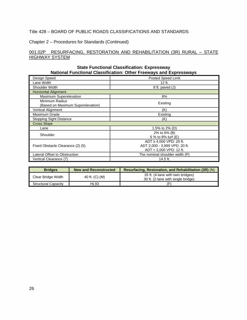
001.02P RESURFACING, RESTORATION AND REHABILITATION (3R) RURAL – STATE HIGHWAY SYSTEM
State Functional Classification: Expressway National Functional Classification: Other Freeways and Expressways
Design Speed Posted Speed Limit
Lane Width 12 ft.
Shoulder Width 8 ft. paved (J)
Horizontal Alignment
Maximum Superelevation 8%
Minimum Radius (Based on Maximum Superelevation)
Existing
Vertical Alignment (K)
Maximum Grade Existing
Stopping Sight Distance (K)
Cross Slope
Lane 1.5% to 2% (D)
Shoulder 2% to 6% (B)
6 % to 8% turf (E)
Fixed Obstacle Clearance (2) (5) ADT ≥ 4,000 VPD: 25 ft.
ADT 2,000 - 3,999 VPD: 20 ft. ADT < 2,000 VPD: 12 ft.
Lateral Offset to Obstruction The nominal shoulder width (P)
Vertical Clearance (7) 14.5 ft.
Bridges New and Reconstructed Resurfacing, Restoration, and Rehabilitation (3R) (N)
Clear Bridge Width 40 ft. (C) (M) 35 ft. (4-lane with twin bridges) 30 ft. (2-lane with single bridge)
Structural Capacity HL93 (F)

Title 428 – BOARD OF PUBLIC ROADS CLASSIFICATIONS AND STANDARDS Chapter 2 – Procedures for Standards (Continued)
27
001.02Q RESURFACING, RESTORATION AND REHABILITATION (3R) RURAL – STATE HIGHWAY SYSTEM
State Functional Classification: Major Arterial National Functional Classification: Other Principal Arterials or Minor Arterial
Design Speed Posted Speed Limit
Lane Width (2) ADT ≥ 750 VPD = 12 ft. ADT < 750 VPD = 11 ft.
Shoulder Width (2)
ADT ≥ 4,000 VPD: 6 ft. paved (J)
ADT 2,000 - 3,999 VPD: 6 ft. total with 2 ft. paved (J)
ADT 750 - 1,999 VPD: 3 ft. (J)
ADT < 750 VPD: 2 ft.
Horizontal Alignment
Maximum Superelevation 8%
Minimum Radius (Based on Maximum Superelevation)
Existing
Vertical Alignment (2) ADT ≥ 2,000 VPD (K) ADT ≤ 1,999 VPD: (L)
Maximum Grade Existing
Stopping Sight Distance ADT ≥ 2,000 VPD (K) ADT ≤ 1,999 VPD: (L)
Cross Slope
Lane 1.5% to 2% (D)
Shoulder 2% to 6% paved (B)
6% to 8% turf and aggregate (E)
Fixed Obstacle Clearance (2) (5) ADT ≥ 4,000 VPD: 25 ft.
ADT 2,000 - 3,999 VPD: 20 ft. ADT < 2,000 VPD: 12 ft.
Lateral Offset to Obstruction The nominal shoulder width (P)
Vertical Clearance (7) 14.5 ft.
Bridges New and Reconstructed Resurfacing, Restoration, and Rehabilitation
(3R) (N)
Clear Bridge Width (2)
ADT ≥ 4,000 VPD: 44 ft. (C) (M) ADT ≥ 4,000 VPD: 30 ft.
ADT 2,000 - 3,999 VPD: 40 ft. (M)
ADT < 4,000 VPD: 28 ft. ADT 400 - 1,999 VPD: 36 ft. (M)
ADT< 400 VPD: 32 ft. (M)
Structural Capacity HL93 (F)
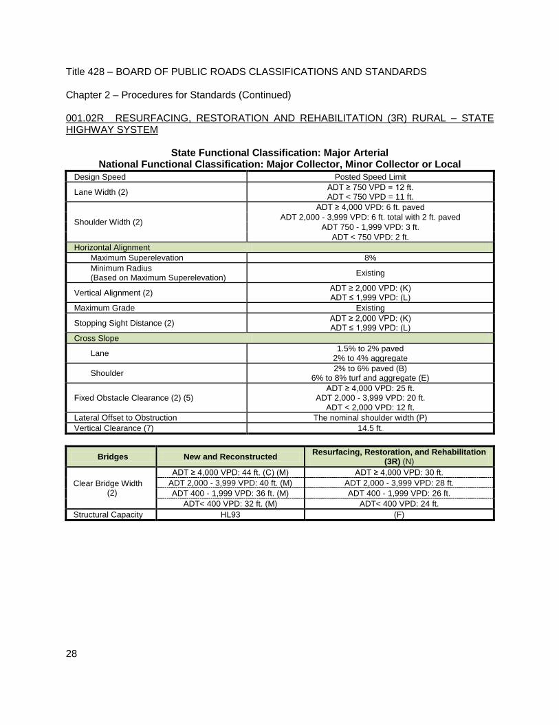
Title 428 – BOARD OF PUBLIC ROADS CLASSIFICATIONS AND STANDARDS Chapter 2 – Procedures for Standards (Continued)
28
001.02R RESURFACING, RESTORATION AND REHABILITATION (3R) RURAL – STATE HIGHWAY SYSTEM
State Functional Classification: Major Arterial National Functional Classification: Major Collector, Minor Collector or Local
Design Speed Posted Speed Limit
Lane Width (2) ADT ≥ 750 VPD = 12 ft. ADT < 750 VPD = 11 ft.
Shoulder Width (2)
ADT ≥ 4,000 VPD: 6 ft. paved
ADT 2,000 - 3,999 VPD: 6 ft. total with 2 ft. paved
ADT 750 - 1,999 VPD: 3 ft.
ADT < 750 VPD: 2 ft.
Horizontal Alignment
Maximum Superelevation 8%
Minimum Radius (Based on Maximum Superelevation)
Existing
Vertical Alignment (2) ADT ≥ 2,000 VPD: (K) ADT ≤ 1,999 VPD: (L)
Maximum Grade Existing
Stopping Sight Distance (2) ADT ≥ 2,000 VPD: (K) ADT ≤ 1,999 VPD: (L)
Cross Slope
Lane 1.5% to 2% paved
2% to 4% aggregate
Shoulder 2% to 6% paved (B)
6% to 8% turf and aggregate (E)
Fixed Obstacle Clearance (2) (5) ADT ≥ 4,000 VPD: 25 ft.
ADT 2,000 - 3,999 VPD: 20 ft. ADT < 2,000 VPD: 12 ft.
Lateral Offset to Obstruction The nominal shoulder width (P)
Vertical Clearance (7) 14.5 ft.
Bridges New and Reconstructed Resurfacing, Restoration, and Rehabilitation
(3R) (N)
Clear Bridge Width (2)
ADT ≥ 4,000 VPD: 44 ft. (C) (M) ADT ≥ 4,000 VPD: 30 ft.
ADT 2,000 - 3,999 VPD: 40 ft. (M) ADT 2,000 - 3,999 VPD: 28 ft.
ADT 400 - 1,999 VPD: 36 ft. (M) ADT 400 - 1,999 VPD: 26 ft.
ADT< 400 VPD: 32 ft. (M) ADT< 400 VPD: 24 ft.
Structural Capacity HL93 (F)

Title 428 – BOARD OF PUBLIC ROADS CLASSIFICATIONS AND STANDARDS Chapter 2 – Procedures for Standards (Continued)
29
001.02S RESURFACING, RESTORATION AND REHABILITATION (3R) RURAL – STATE HIGHWAY SYSTEM
State Functional Classification: Scenic-Recreation-Major Arterial National Functional Classification: Other Principal Arterials, Minor Arterial, Major
Collector or Minor Collector
Design Speed Posted Speed Limit
Lane Width Existing
Shoulder Width Existing
Horizontal Alignment
Maximum Superelevation 8%
Minimum Radius (Based on Maximum Superelevation)
Existing
Vertical Alignment Existing
Maximum Grade Existing
Stopping Sight Distance (2) ADT ≥ 2,000 VPD: (K) ADT ≤ 1,999 VPD: (L)
Cross Slope
Lane 1.5% to 2% paved
Shoulder 2% to 8%
Fixes Obstacle Clearance (5) The nominal shoulder width (P)
Lateral Offset to Obstruction The nominal shoulder width (P)
Vertical Clearance (7) 14.5 ft.
Bridges New and Reconstructed Resurfacing, Restoration, and
Rehabilitation (3R)
Clear Bridge Width (2)
ADT ≥ 2,000 VPD: Approach roadway width ADT 400 - 1,999 VPD: Traveled way width plus
3 ft. each side ADT < 400 VPD: Traveled way width plus 2 ft.
each side
Existing
Structural Capacity HL93 (F)

Title 428 – BOARD OF PUBLIC ROADS CLASSIFICATIONS AND STANDARDS Chapter 2 – Procedures for Standards (Continued)
30
001.02T RESURFACING, RESTORATION AND REHABILITATION (3R) MUNICIPAL – STATE HIGHWAY SYSTEM
State Functional Classification: Interstate National Functional Classification: Interstate
Design Speed Posted Speed Limit
Lane Width (I)
Shoulder Width (I)
Horizontal Alignment
Maximum Superelevation 8%
Minimum Radius (Based on Maximum Superelevation)
(I)
Vertical Alignment (I)
Maximum Grade (I)
Stopping Sight Distance (I)
Cross Slope
Lane 1.5% to 2.5% (D)
Shoulder 2% to 6% (B)
Fixed Obstacle Clearance (6) (I)
Lateral Offset to Obstruction The nominal paved shoulder width (P)
Vertical Clearance (7) 16 ft.
Bridges New and Reconstructed Resurfacing, Restoration, and Rehabilitation (3R) (N)
Clear Bridge Width 44 ft. (C) (M) 37.5 ft. with 3.5 ft. minimum shoulder width left.
Structural Capacity HL93 (F)

Title 428 – BOARD OF PUBLIC ROADS CLASSIFICATIONS AND STANDARDS Chapter 2 – Procedures for Standards (Continued)
31
001.02U RESURFACING, RESTORATION AND REHABILITATION (3R) MUNICIPAL – STATE HIGHWAY SYSTEM
State Functional Classification: Expressway (Access Only At Interchanges) National Functional Classification: Principal Arterial – Other Freeways and Expressways
THERE ARE NO 3R STANDARDS FOR EXPRESSWAY (ACCESS ONLY AT INTERCHANGES) USE THE 001.02J NEW AND RECONSTRUCTED MUNICIPAL – STATE HIGHWAY SYSTEM TABLE
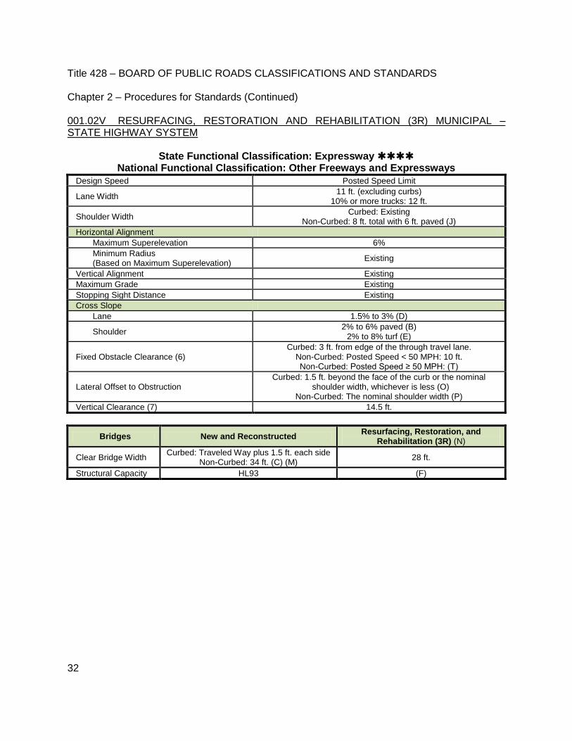
Title 428 – BOARD OF PUBLIC ROADS CLASSIFICATIONS AND STANDARDS Chapter 2 – Procedures for Standards (Continued)
32
001.02V RESURFACING, RESTORATION AND REHABILITATION (3R) MUNICIPAL – STATE HIGHWAY SYSTEM
State Functional Classification: Expressway National Functional Classification: Other Freeways and Expressways
Design Speed Posted Speed Limit
Lane Width 11 ft. (excluding curbs)
10% or more trucks: 12 ft.
Shoulder Width Curbed: Existing
Non-Curbed: 8 ft. total with 6 ft. paved (J)
Horizontal Alignment
Maximum Superelevation 6%
Minimum Radius (Based on Maximum Superelevation)
Existing
Vertical Alignment Existing
Maximum Grade Existing
Stopping Sight Distance Existing
Cross Slope
Lane 1.5% to 3% (D)
Shoulder 2% to 6% paved (B)
2% to 8% turf (E)
Fixed Obstacle Clearance (6) Curbed: 3 ft. from edge of the through travel lane.
Non-Curbed: Posted Speed < 50 MPH: 10 ft. Non-Curbed: Posted Speed ≥ 50 MPH: (T)
Lateral Offset to Obstruction Curbed: 1.5 ft. beyond the face of the curb or the nominal
shoulder width, whichever is less (O) Non-Curbed: The nominal shoulder width (P)
Vertical Clearance (7) 14.5 ft.
Bridges New and Reconstructed Resurfacing, Restoration, and
Rehabilitation (3R) (N)
Clear Bridge Width Curbed: Traveled Way plus 1.5 ft. each side
Non-Curbed: 34 ft. (C) (M) 28 ft.
Structural Capacity HL93 (F)

Title 428 – BOARD OF PUBLIC ROADS CLASSIFICATIONS AND STANDARDS Chapter 2 – Procedures for Standards (Continued)
33
001.02W RESURFACING, RESTORATION AND REHABILITATION (3R) MUNICIPAL – STATE HIGHWAY SYSTEM
State Functional Classification: Major Arterial National Functional Classification: Other Principal Arterials or Minor Arterial
Design Speed Posted Speed Limit
Lane Width 11 ft. (excluding curbs)
10% or more trucks: 12 ft.
Shoulder Width (2)
Curbed: Existing ADT ≥ 4,000 VPD: 8 ft. with 6 ft. paved (J)
ADT 2,000 - 3,999 VPD: 5 ft. (J) ADT < 2,000 VPD: 2 ft.
Horizontal Alignment
Maximum Superelevation 4%
Minimum Radius (Based on Maximum Superelevation)
Existing
Vertical Alignment Existing
Maximum Grade Existing
Stopping Sight Distance Existing
Cross Slope
Lane 1.5% to 3%
Shoulder 2% to 6% paved (B)
6% to 8% turf and aggregate (E)
Fixed Obstacle Clearance (6) Curbed: 3 ft. from edge of the through travel lane
Non-Curbed: Posted Speed < 50 MPH: 10 ft. Non-Curbed: Posted Speed ≥ 50 MPH: (T)
Lateral Offset to Obstruction Curbed: 1.5 ft. beyond the face of the curb or the nominal
shoulder width, whichever is less (O) Non-Curbed: The nominal shoulder width (P)
Vertical Clearance (7) 14.5 ft.
Bridges New and Reconstructed Resurfacing,
Restoration, and Rehabilitation (3R) (N)
Clear Bridge Width (2)
Curbed Traveled Way plus 1.5 ft. each side Curbed: 23 ft. (G)
Non-Curbed: Posted Speed Limit
< 50 MPH
ADT ≥ 4,000 VPD: 38 ft.(C) (M)
Non-Curbed: 28 ft.
ADT 2,000 - 3,999 VPD: 38 ft. (M)
ADT 400 - 1,999 VPD: 34 ft. (M)
ADT< 400 VPD: 30 ft. (M)
Non-Curbed: Posted Speed Limit
≥ 50 mph
Use the 001.02D New and Reconstructed Rural – State
Highway System Table
Structural Capacity HL93 (F)

Title 428 – BOARD OF PUBLIC ROADS CLASSIFICATIONS AND STANDARDS Chapter 2 – Procedures for Standards (Continued)
34
001.02X RESURFACING, RESTORATION AND REHABILITATION (3R) MUNICIPAL – STATE HIGHWAY SYSTEM
State Functional Classification: Major Arterial National Functional Classification: Major Collector or Minor Collector
Design Speed Posted Speed Limit
Lane Width 11 ft. (excluding curbs)
10% or more Trucks: 12 ft.
Shoulder Width (2)
Curbed: Existing
ADT ≥ 4,000 VPD: 8 ft. with 6 ft. paved ADT 2,000 - 3,999 VPD: 5 ft.
ADT < 2,000 VPD: 2 ft.
Horizontal Alignment
Maximum Superelevation 4%
Minimum Radius
(Based on Maximum Superelevation)
Existing
Vertical Alignment Existing
Maximum Grade Existing
Stopping Sight Distance Existing
Cross Slope
Lane 1.5% to 3%
Shoulder 2% to 6% paved (B)
6% to 8% turf and aggregate (E)
Fixed Obstacle Clearance (6) Curbed: 3 ft. from edge of the through travel lane
Non-Curbed: Posted Speed < 50 MPH: 10 ft. Non-Curbed: Posted Speed ≥ 50 MPH: (T)
Lateral Offset to Obstruction Curbed: 1.5 ft. beyond the face of the curb or the nominal
shoulder width, whichever is less (O) Non-Curbed: The nominal shoulder width (P)
Vertical Clearance (7) 14.5 ft.
Bridges New and Reconstructed Resurfacing, Restoration, and Rehabilitation (3R) (N)
Clear Bridge Width
(2)
Curbed Traveled Way plus 1.5 ft. each side Curbed: 23 ft. (G)
Non-Curbed:
Posted Speed Limit
< 50 MPH
ADT ≥ 4,000 VPD: 38 ft. (C) (M)
Non-Curbed: ADT ≥ 2,000 VPD: 28 ft.
ADT 1,500 - 1,999 VPD: 24 ft.
ADT < 1,500 VPD: 22 ft.
ADT 2,000 - 3,999 VPD: 38 ft. (M)
ADT 400 - 1,999 VPD: 34 ft. (M)
ADT< 400 VPD: 26 ft. (M)
Non-Curbed:
Posted Speed Limit
≥ 50 MPH
Use the 001.02R New and Reconstructed Rural – State Highway
System Table
Structural Capacity HL93 (F)
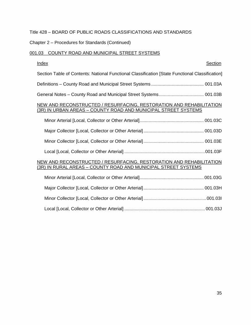
Title 428 – BOARD OF PUBLIC ROADS CLASSIFICATIONS AND STANDARDS Chapter 2 – Procedures for Standards (Continued)
35
001.03 COUNTY ROAD AND MUNICIPAL STREET SYSTEMS Index Section Section Table of Contents: National Functional Classification [State Functional Classification] Definitions – County Road and Municipal Street Systems ......................................... 001.03A General Notes – County Road and Municipal Street Systems ................................... 001.03B NEW AND RECONSTRUCTED / RESURFACING, RESTORATION AND REHABILITATION (3R) IN URBAN AREAS – COUNTY ROAD AND MUNICIPAL STREET SYSTEMS
Minor Arterial [Local, Collector or Other Arterial] .................................................. 001.03C Major Collector [Local, Collector or Other Arterial] ............................................... 001.03D Minor Collector [Local, Collector or Other Arterial] ............................................... 001.03E Local [Local, Collector or Other Arterial] ............................................................... 001.03F
NEW AND RECONSTRUCTED / RESURFACING, RESTORATION AND REHABILITATION (3R) IN RURAL AREAS – COUNTY ROAD AND MUNICIPAL STREET SYSTEMS
Minor Arterial [Local, Collector or Other Arterial] .................................................. 001.03G Major Collector [Local, Collector or Other Arterial] ............................................... 001.03H Minor Collector [Local, Collector or Other Arterial] ................................................. 001.03I Local [Local, Collector or Other Arterial] ............................................................... 001.03J
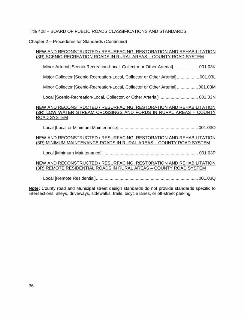
Title 428 – BOARD OF PUBLIC ROADS CLASSIFICATIONS AND STANDARDS Chapter 2 – Procedures for Standards (Continued)
36
NEW AND RECONSTRUCTED / RESURFACING, RESTORATION AND REHABILITATION (3R) SCENIC-RECREATION ROADS IN RURAL AREAS – COUNTY ROAD SYSTEM
Minor Arterial [Scenic-Recreation-Local, Collector or Other Arterial] .................... 001.03K Major Collector [Scenic-Recreation-Local, Collector or Other Arterial] .................. 001.03L Minor Collector [Scenic-Recreation-Local, Collector or Other Arterial] ................. 001.03M Local [Scenic-Recreation-Local, Collector, or Other Arterial] ............................... 001.03N
NEW AND RECONSTRUCTED / RESURFACING, RESTORATION AND REHABILITATION (3R) LOW WATER STREAM CROSSINGS AND FORDS IN RURAL AREAS – COUNTY ROAD SYSTEM
Local [Local or Minimum Maintenance] ................................................................ 001.03O
NEW AND RECONSTRUCTED / RESURFACING, RESTORATION AND REHABILITATION (3R) MINIMUM MAINTENANCE ROADS IN RURAL AREAS – COUNTY ROAD SYSTEM
Local [Minimum Maintenance] ............................................................................. 001.03P
NEW AND RECONSTRUCTED / RESURFACING, RESTORATION AND REHABILITATION (3R) REMOTE RESIDENTIAL ROADS IN RURAL AREAS – COUNTY ROAD SYSTEM
Local [Remote Residential] .................................................................................. 001.03Q
Note: County road and Municipal street design standards do not provide standards specific to intersections, alleys, driveways, sidewalks, trails, bicycle lanes, or off-street parking.

Title 428 – BOARD OF PUBLIC ROADS CLASSIFICATIONS AND STANDARDS Chapter 2 – Procedures for Standards (Continued)
37
001.03A DEFINITIONS – COUNTY ROAD AND MUNICIPAL STREET SYSTEMS
001.03A1 TYPES OF WORK
001.03A1a NEW CONSTRUCTION New construction refers to a roadway, bridge, non-buried structure or culvert built on essentially new alignment. Full geometric standards are used to satisfy both the current as well as long-term traffic needs. 001.03A1b RECONSTRUCTION Reconstruction refers to rebuilding a roadway, bridge, non-buried structure or culvert along an existing alignment. Reconstruction work normally involves a substantial construction effort to rebuild the existing facility. Design deficiencies and functional obsolescence of the roadway and structures, as well as the future traffic needs of the area, should be addressed. Typical work includes:
removal of the entire surfacing or pavement and modifying or adding a base,
paving (any thickness) an existing unpaved road,
significant modifications to the roadway’s existing horizontal and/or vertical alignment, including alignment shifts.
adding through travel lanes to the roadway,
replacement of bridges, non-buried structures and culverts, and
lengthening (parallel to roadway alignment) bridges or non-buried structures.
While reconstruction approximately follows an existing road corridor, it may deviate significantly in width and alignment from the present road to achieve the work’s purpose and need and the required geometric standards.
001.03A1c RESURFACING, RESTORATION, REHABILITATION (3R) 3R work refers to the preservation and extension of the service life of existing facilities and may also add safety enhancements using safety conscious design. The improvements, whether continuous or at selected locations, should satisfy existing and future traffic needs and conditions in a manner conducive to safety, durability, and economy of maintenance.

Title 428 – BOARD OF PUBLIC ROADS CLASSIFICATIONS AND STANDARDS Chapter 2 – Procedures for Standards (Continued)
38
Work done under 3R standards may not address all the deficiencies of the roadway. Some potential problem areas or substandard features may remain to be addressed as part of future reconstruction work. Under 3R standards, the types of improvements to existing facilities include, but are not limited to:
resurfacing,
addition of auxiliary lanes,
lane and shoulder widening,
selected alterations to grades, and horizontal and/or vertical curves,
guardrail and bridge rail upgrades,
replacement of the entire superstructure of a bridge or non-buried structure (Rehabilitated bridges),
extension (perpendicular to roadway alignment) of culverts,
re-decking and/or widening a bridge or non-buried structure,
thin Portland cement concrete overlay on a bridge or non-buried structure, and
removal or protection of roadside obstacles within the horizontal clear zone.
For the purpose of these rules and regulations, certain types of work including but not limited to the following, do not by themselves require the application of 3R standards or New and Reconstructed standards:
elimination of barriers to access for the disabled as required by federal or state law, regulation or guidance,
sidewalks, and
trails.

Title 428 – BOARD OF PUBLIC ROADS CLASSIFICATIONS AND STANDARDS Chapter 2 – Procedures for Standards (Continued)
39
001.03A1d THRESHOLD BETWEEN 3R AND OTHER STANDARDS For the purposes of this rule and regulation, the threshold between the application of 3R standards and other standards (New and Reconstructed or Maintenance) is a function of the extent of work on the base, pavement, bridge, or unpaved road/street. Refer also to Title 428 Chapter 2 Section 003 for additional information regarding the application of Maintenance standards.
001.03A1d1 BASE
If the surfacing or pavement structure is removed to the base, but the base is not removed, replaced, or strengthened, then 3R standards or better apply. 3R work may include minor repairs to the base, replacing the base at selected safety improvement locations (minor alterations of grades, vertical and horizontal curves), and recycling strategies which incorporate the existing road surfacing or structure into the base.
If the entire surfacing or the entire pavement is removed and the entire existing base is replaced or an entire new base is placed for the traveled way, then the work is reconstruction, and New and Reconstructed standards apply.
001.03A1d2 PAVEMENT REHABILITATION Pavement rehabilitation consists of structural enhancements that extends the service life of an existing pavement and/or improves its load carrying capacity. With respect only to pavement resurfacing, placing 2 inches or less equivalent structure (asphaltic concrete equivalent thickness) of any pavement material would not by itself require the application of 3R standards. Placing more than 2 inches up to and including 6 inches of
asphaltic concrete equivalent structure of bituminous materials, or
nominal structure depth for pavement applications of Portland concrete materials
requires that 3R standards or better apply.
Title 428 – BOARD OF PUBLIC ROADS CLASSIFICATIONS AND STANDARDS Chapter 2 – Procedures for Standards (Continued)
40
With respect only to pavement resurfacing, placing less than 6 inches equivalent structure (asphaltic concrete equivalent thickness) of any pavement material would not by itself require the application of New and Reconstructed standards. If more than 6 inches of
asphaltic concrete equivalent structure of bituminous materials, or
nominal structure depth for pavement applications of Portland concrete materials
is placed, then New and Reconstructed standards shall apply. For all applications of bituminous materials, including asphalt and recycling strategies, asphaltic concrete equivalent thickness is an abstract number, based on a structural number value, expressing the structural strength of pavement required for given combinations of soil support, traffic loads, terminal serviceability and environments. 001.03A1d3 BRIDGE 3R standards apply to work beyond that described in Maintenance standards but less than New and Reconstructed standards (replacement of an existing bridge or non-buried structure). Rehabilitated bridge work is a 3R strategy which includes replacement of the entire superstructure. However, note that replacement of a timber superstructure with an in-kind timber superstructure, on county roads and municipal streets with a National functional classification of Local and an ADT less than 400 VPD, can be done under Maintenance standards. 001.03A1d4 UNPAVED ROADS AND STREETS, LIMITATIONS Work done under 3R standards (a) to convert a paved road or street to unpaved or (b) on an existing unpaved road or street, is limited to minor adjustments in vertical and/or horizontal alignment, adding or modifying guardrail, 3R work on bridges and non-buried structures, or culvert extensions. Work beyond this scope requires the application of New and Reconstructed standards.
001.03A1e APPLICATION OF STANDARDS TO WORK SEGMENTS These Minimum Design Standards do not require that a single category of Design Standard be applied to the entire length of a roadway. For example, work on a roadway may include a segment that is mill 2 inches and place 2 inches designed to Maintenance standards, a segment that is mill 4 inches place 4 inches designed to 3R standards and a segment where a bridge, non-buried structure, or culvert being replaced is designed to New and Reconstructed standards.
Title 428 – BOARD OF PUBLIC ROADS CLASSIFICATIONS AND STANDARDS Chapter 2 – Procedures for Standards (Continued)
41
001.03A1f SAFETY CONSCIOUS DESIGN With regard to work that requires the application of 3R standards; safety conscious design means systematically considering safety improvements, such as geometric, roadside and traffic control improvements, when designing a road or street to 3R standards. Safety is treated as an integral part of design and not as a secondary objective. 001.03A1g COST EFFECTIVE ANALYSIS FOR 3R WORK With regard to work that requires the application of 3R standards, a cost effective analysis compares costs of implementing, installing, or constructing a safety improvement to its user benefits. User benefits are typically crash cost reductions, which result from an estimated reduction in frequency and/or severity of crashes. A cost effective analysis typically:
Identifies potential opportunities for safety improvements based on o A crash history compilation for the work location o Determining if there is a link between crashes and a design criterion
or criteria (e.g. vertical alignment, horizontal alignment, etc.) o If there is a link, and a significant number and severity of crashes
relevant to a design criterion or criteria, and no mitigating factors, then a benefit/cost analysis is performed.
Identifies design options for the potential safety improvement opportunities and
Analyzes the cost of implementing, installing, or constructing those design options and any other relevant impacts. o Costs of a safety improvement may include such items as additional
construction, environmental compliance, preliminary engineering, construction engineering, right-of-way acquisition, utilities, contingencies, and estimated costs of delay including maintenance costs to maintain the roadway during the delay as well as the inflation costs associated with the delay. Maintenance costs can be estimated, for example, by using an average of the last five years.
Estimates user benefits, i.e. crash cost reductions which would result from implementing, installing, or construction of the design options.
The length and complexity of the cost effective analysis will vary depending on existing conditions and the extent of any safety problems.

Title 428 – BOARD OF PUBLIC ROADS CLASSIFICATIONS AND STANDARDS Chapter 2 – Procedures for Standards (Continued)
42
001.03A1h CONSTRAINED SITUATION A constrained situation is a site-specific condition such as terrain, right-of-way, social impact, environmental impacts, and/or cost that may make meeting a design standard impractical.
001.03A2 AREAS
001.03A2a URBAN AREA An urban area consists of those places within boundaries set by the responsible state and local officials having a population of 5,000 or more. Urban Area boundaries are not necessarily the same as corporate limits; they can be outside the corporate limits. 001.03A2b RURAL AREA A rural area is any place outside the boundaries of an urban area.
001.03A3 TRAFFIC VOLUME
001.03A3a ADT Average Daily Traffic (ADT) – The average of 24-hour traffic counts collected over a number of days greater than one day but less than one year. 001.03A3b HEAVY TRUCKS Heavy trucks consist of buses, single-unit trucks, combination trucks, and recreational vehicles. The term “truck” often references these vehicles as well, so often the terms are interchangeable. The term does not refer to light trucks such as pick-ups. For traffic-classification purposes, trucks are normally defined as those vehicles having manufacturer's gross vehicle weight (GVW) ratings of 4,000 kilogram [9,000 pounds] or more and having dual tires on at least one rear axle. The percent (%) of heavy trucks (%HT) expresses heavy trucks as a percentage of all traffic on a highway, road or street.
001.03A4 THE ROADWAY
001.03A4a ROADWAY The roadway is the portion of a road or street including shoulders, for vehicular use. A divided road or street has separated roadways for traffic in opposite directions. 001.03A4b BASE A base consists of all layers directly or sequentially underneath the roadway surface including layers such as foundation course and subgrade.
Title 428 – BOARD OF PUBLIC ROADS CLASSIFICATIONS AND STANDARDS Chapter 2 – Procedures for Standards (Continued)
43
001.03A4c TRAVELED WAY The traveled way is the portion of the roadway for the movement of vehicles, exclusive of shoulders and bicycle lanes. 001.03A4d THROUGH TRAVEL LANE A through travel lane is a portion of the traveled way designated for movement of vehicles in one direction or for shared use. 001.03A4e AUXILIARY LANE An auxiliary lane is the portion of the roadway adjoining the traveled way for speed change, turning, weaving, truck climbing, maneuvering of entering and leaving traffic, and other purposes supplementary to through-traffic movement. Examples of auxiliary lanes include bicycle lanes, turn bays, extended length right-turn lanes, and bus lanes. 001.03A4f SHOULDER A shoulder is the portion of the roadway adjacent to the non-curbed traveled way or an auxiliary lane that accommodates stopped vehicles, emergency use and lateral support of subbase, base and surface courses. 001.03A4g NOMINAL SHOULDER WIDTH The nominal shoulder width is the shoulder width value presented in the minimum standards tables. 001.03A4h CURBED SECTION A curbed section is a roadway with a curb placed adjacent to the outside (right) edge of the traveled way or to an auxiliary lane. Curbs serve any or all of the following purposes: drainage control, roadway edge delineation, right-of-way reduction, aesthetics, delineation of pedestrian walkways, reduction of maintenance operations, and assistance in orderly roadside development. A curb, by definition, incorporates a raised or vertical element. 001.03A4i NON-CURBED SECTION A non-curbed section is a roadway with a shoulder placed adjacent to the outside (right) edge of the traveled way, or to an auxiliary lane. When designing to high speeds (50 MPH and greater), a section with curb placed at the outside (right) edge of the shoulder (typically for drainage) is considered, in effect, a non-curbed section for purposes of determining the Horizontal Clear Zone area. 001.03A4j TANGENT A tangent is a straight line that touches a horizontal or vertical curve at a single point.

Title 428 – BOARD OF PUBLIC ROADS CLASSIFICATIONS AND STANDARDS Chapter 2 – Procedures for Standards (Continued)
44
001.03A4k ROADSIDE Roadside is the right-of-way area outside the traveled way. (See also 001.03A6k.)
001.03A5 STRUCTURES AND CROSSINGS
001.03A5a BRIDGE A structure including supports erected over a depression or an obstruction, such as water, highway, or railway, and having a track or passageway for carrying traffic or other moving loads, and having an opening measured along the center of the roadway of more than 20 feet between undercopings of abutments or spring lines of arches, or extreme ends of openings for multiple boxes; it may also include multiple pipes, where the clear distance between openings is less than half of the smaller contiguous opening. 001.03A5b CULVERT A closed conduit used to convey water from one area to another, usually from one side of a road or street to the other side. 001.03A5c NON-BURIED STRUCTURE A non-buried structure is a structure including supports erected over a depression or an obstruction, such as water or a trail, having a track or passageway for carrying traffic or other moving loads, an opening measured along the center of the roadway of 20 feet or less, and has 2 feet or less of fill or pavement material placed on top of the structure. Examples include concrete, steel and timber structures, concrete slab structures, culverts, corrugated metal pipes, etc. 001.03A5d LOW WATER STREAM CROSSING A low water stream crossing shall be defined as a stream crossing structure that is designed and constructed so that it shall convey the normal stream flow below the driving surface, but normally will be overtopped by floods at least once annually. 001.03A5e FORD A ford is a shallow place where a river, creek or stream may be crossed by a vehicle. A ford is mostly a natural phenomenon, in contrast to a low water stream crossing, which is a bridge, non-buried structure or culvert that allows crossing a river, creek or stream when water is low.
Title 428 – BOARD OF PUBLIC ROADS CLASSIFICATIONS AND STANDARDS Chapter 2 – Procedures for Standards (Continued)
45
001.03A6 DESIGN CRITERIA 001.03A6a DESIGN SPEED Design speed is a selected speed used to determine the various geometric features of the roadway. The assumed design speed should be a logical one with respect to the topography, anticipated operating speed, the adjacent land use, and the functional classification of the road or street. 001.03A6b LANE WIDTH Lane width is the width of through travel lanes, auxiliary lanes, ramps, and turning roadways. It does not include bicycle lanes, shoulders, curbs, or on-street parking areas.
001.03A6c SHOULDER WIDTH Shoulder width is the width of the portion of the roadway adjacent to a non-curbed traveled way for accommodation of stopped or disabled vehicles, maneuvering area for avoiding crashes, emergency use, enforcement use, lateral support of the base and surface courses and other uses.
001.03A6d HORIZONTAL ALIGNMENT Horizontal alignment refers to the horizontal curvature of the roadway, i.e. the route of the road consisting of a series of horizontal tangents and curves.
001.03A6d1 SUPERELEVATION Superelevation is the rotation of the pavement on the approach to and through a horizontal curve. It is intended to assist the driver by counteracting the lateral acceleration produced by tracking the curve. 001.03A6d2 MINIMUM RADIUS The adopted design criteria specify a minimum radius for the selected design speed, which is calculated from the maximum rate of superelevation and the side friction factor. Horizontal alignment influences another primary controlling criterion, stopping sight distance.
001.03A6e VERTICAL ALIGNMENT Vertical alignment refers to the vertical curvature and grade of the roadway. The roadway profile is the vertical aspect of the road, including crest (“hill”) and sag (“valley”) curves, and the straight grade lines connecting them. Vertical curves create a gradual transition between different grades which is essential for the safe and efficient operation of a roadway. The lengths of both crest and sag vertical curves influence another controlling criterion, stopping sight distance.

Title 428 – BOARD OF PUBLIC ROADS CLASSIFICATIONS AND STANDARDS Chapter 2 – Procedures for Standards (Continued)
46
001.03A6e1 K VALUE K is a measure of curvature calculated or measured by the length of a vertical curve divided by the algebraic difference of the grades on either side of the vertical curve. K values represent the horizontal distance along which a 1% change in grade occurs on a vertical curve. 001.03A6e2 GRADE Grade is the rate of change of the vertical alignment, i.e. the slope or “steepness” of a roadway.
001.03A6f STOPPING SIGHT DISTANCE Stopping sight distance is the distance needed for drivers to see an object on the roadway ahead and bring their vehicles to a safe stop before colliding with the object. The distances are derived for various design speeds based on assumptions for driver reaction time, the braking ability of most vehicles under wet pavement conditions, and the friction provided by most pavement surfaces, assuming good tires. Stopping sight distance is influenced by both vertical and horizontal alignment. A roadway designed to criteria employs a horizontal and vertical alignment and a cross section that provides at least the minimum stopping sight distance through the entire facility. 001.03A6g CROSS SLOPE Cross slope is the slope of a lane or shoulder transverse to the centerline of the roadway. 001.03A6h VERTICAL CLEARANCE Vertical clearance refers to the height above the roadway surface to the nearest edge of a structure at underpasses, or at pedestrian, bicycle and overhead sign structures. 001.03A6i CLEAR BRIDGE WIDTH Clear bridge width is the total width of all lanes and shoulders on the bridge, measured between points on the bridge rail, curb, or other vertical elements that project the farthest onto the roadway. 001.03A6j STRUCTURAL CAPACITY Structural capacity is the load-carrying capacity of a bridge or structure. 001.03A6k HORIZONTAL CLEAR ZONE Horizontal Clear Zone is an unobstructed, traversable area provided beyond the edge of traveled way for the recovery of errant vehicles. It includes shoulders and auxiliary lanes unless the auxiliary lane functions like a through travel lane.

Title 428 – BOARD OF PUBLIC ROADS CLASSIFICATIONS AND STANDARDS Chapter 2 – Procedures for Standards (Continued)
47
001.03B GENERAL NOTES – COUNTY ROAD AND MUNICIPAL STREET SYSTEMS – Applicable to Specific County Roads and Municipal Streets Tables. Bold Font – Requires Relaxation of Standards if Requirement is Not Met.
1
A value in the table is a minimum value unless otherwise expressed as a range or a maximum value. If any value cannot be met, a relaxation of standards request is required; the request must be granted by the Board in order to use the proposed value in lieu of the standard value.
2 Rural Area design standards shall be used for New and Reconstructed roads and streets when the anticipated posted speed limit is greater than or equal to 50 MPH.
3
Urban Area design standards may be used in lieu of Rural Area design standards in residential and commercial areas lying outside urban area boundaries. This may be particularly appropriate for cities of the second class, villages, Sanitary and Improvement Districts and for areas within the municipal zoning jurisdiction. It is not permissible to use Urban Area design standards and Rural Area design standards for the same segment of road or street.
Scenic-Recreation-Internal County Roads. Minimum design standards within the recreational area shall be consistent with the established speed limits, the topography and use of the facility. Design may be to either urban or rural standards depending on terrain conditions.
4 County roads and municipal streets with a National functional classification of Other Principal Arterial or higher shall use applicable State Highway Standards.
5
The design of a road or street must meet the standards of the functional classification to which it is assigned. NDOR must be consulted to establish a functional classification that will apply to a new road or street. NDOR must also be consulted for any proposed work, project or changed circumstance that may cause the road or street to no longer fit the existing functional classification. (See also Neb. Rev. Stat. §39-2112.)
6
Resurfacing, restoration and rehabilitation (3R) work has the fundamental principle of utilizing safety conscious design in order to extend the life of the transportation asset. This requires, in reference to “existing,” i.e. existing design features, in the tables, a cost effective analysis (except as indicated in notes 12 and 13). If user benefits are greater than the cost of implementing, installing, or constructing the safety improvement, then the scope of work shall include the safety improvement.

Title 428 – BOARD OF PUBLIC ROADS CLASSIFICATIONS AND STANDARDS Chapter 2 – Procedures for Standards (Continued)
48
7
Traffic Volume, Current and Future. For average daily traffic (ADT) fewer than 750 vehicles per day (VPD), the traffic volume for the year of the anticipated completion of work shall be used as a minimum. For ADT of 750 VPD and greater, or for any road or street on the National Highway System (National functional classification of Other Principal Arterial or higher), the ADT shall be based on the anticipated completion of work as follows:
For New and Reconstructed work, a minimum of 20 years
For 3R work, 10 years for asphaltic pavement strategies and 20 years for Portland cement pavement strategies.
8
Design Speed for New and Reconstructed standards shall be at least equal to or greater than the anticipated posted speed limit. The anticipated speed limit shall be used if the speed limit is to be adjusted following construction. If no speed limit is posted, the statutory speed limit shall be used. (See Neb. Rev. Stat. §§60-6,186 and 60-6,190.) Urban Area design standards tables provide values for only the highest and lowest design speeds for New and Reconstructed work. Rural Areas and Scenic-Recreation design standards tables, not including Minimum Maintenance or Remote Residential, provide New and Reconstructed minimum values for unpaved roads (50 MPH) and for paved roads (55 MPH); (see notes 10, 12, 13, and 14 for design speed exceptions). All design criteria which are a function of design speed (horizontal alignment, vertical alignment, grade, and stopping sight distance) must be based on the formula or values in the 2011 edition of AASHTO’s “A Policy on Geometric Design of Highways and Streets” for selected design speeds not shown. Scenic-Recreation-Internal County Roads. Minimum design speed permissible is 20 MPH. Values for design criteria based on design speed may be lower than minimum (or higher than maximum) values in the table, consistent with the selected design speed.

Title 428 – BOARD OF PUBLIC ROADS CLASSIFICATIONS AND STANDARDS Chapter 2 – Procedures for Standards (Continued)
49
9
Lane Width for lanes adjacent to a curb shall be measured from the gutter line. For this standard, the gutter line shall be the point 1 ft. inside the back of the curb. Values in the tables apply to through travel lanes, and to auxiliary lanes exclusive of bicycle lanes and parking lanes. For purposes of these standards, road or street paint striping shall not be used to determine lane width.
10
Sandhills Soils New and Reconstructed Work. Some roads located in “Sandhills” soils may require paving because of the light, granular nature of the soils. For such roads with a National functional classification of Local or Minor Collector, (excluding roads with a State functional classification of Minimum Maintenance and Remote Residential) and an ADT fewer than 50 VPD (250 VPD for roads with a State functional classification of Scenic-Recreation) designed and built to Rural Area standards:
The minimum design speed for New and Reconstructed work shall be 50 MPH. (See notes 12, 13 and 14 for exceptions.)
It is permissible to build a shared 12 ft. wide paved surface or crushed aggregate surfacing of any type, approximately centered in a full two-lane cross section; all other minimum standards criteria apply including minimum clear bridge widths.
11
Shoulder Width. The shoulder width values in the tables are for non-divided roads and streets only. Non-curbed divided roads and streets shall have the following minimum shoulder widths.
New and Reconstructed: 8 ft. total with 4 ft. paved outside (right) shoulder. 4 ft. paved inside (left) shoulder for High Speed (50 MPH or greater) or 2 ft. paved for Low Speed (Less than 50 mph).
3R: 6 ft. total with 4 ft. paved outside (right) shoulder. For the inside (left) shoulder, the existing shoulder width may be used.
For purposes of these standards, road or street paint striping shall not be used to determine shoulder width.
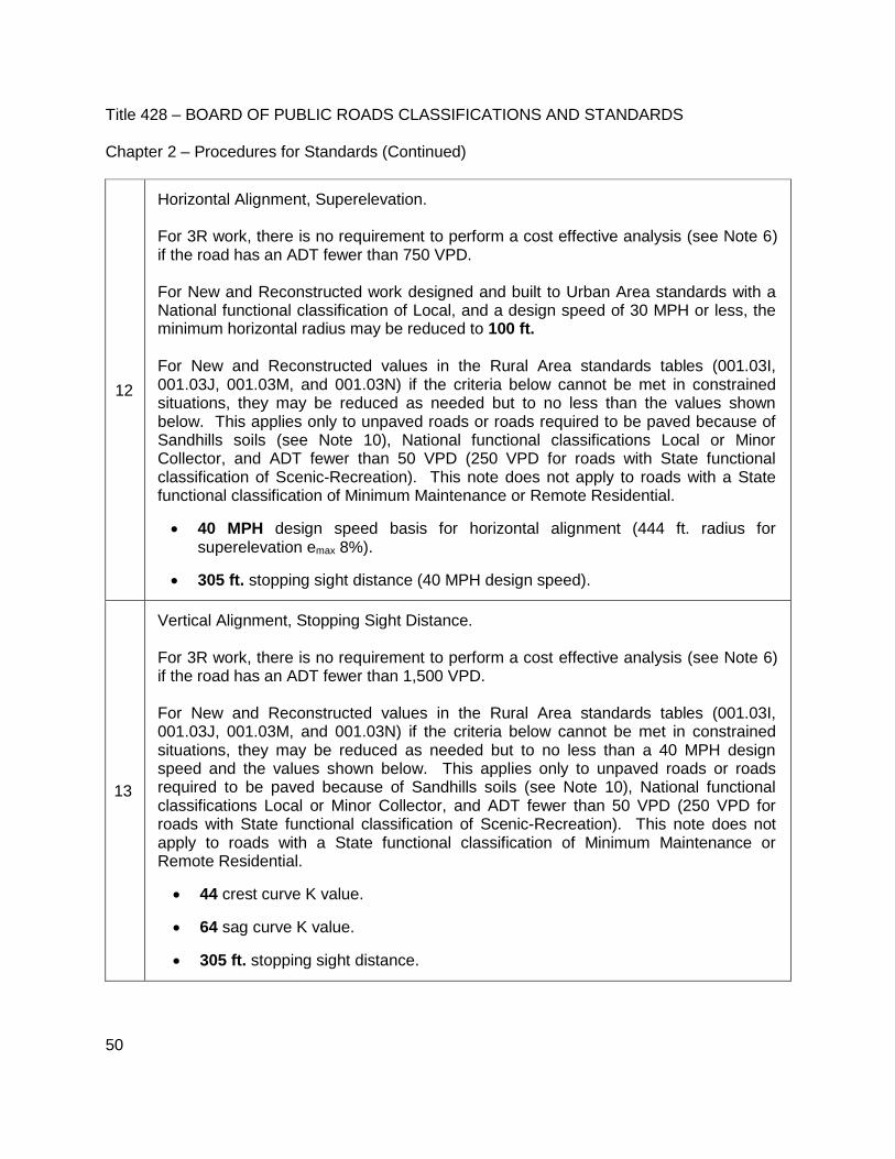
Title 428 – BOARD OF PUBLIC ROADS CLASSIFICATIONS AND STANDARDS Chapter 2 – Procedures for Standards (Continued)
50
12
Horizontal Alignment, Superelevation. For 3R work, there is no requirement to perform a cost effective analysis (see Note 6) if the road has an ADT fewer than 750 VPD. For New and Reconstructed work designed and built to Urban Area standards with a National functional classification of Local, and a design speed of 30 MPH or less, the minimum horizontal radius may be reduced to 100 ft. For New and Reconstructed values in the Rural Area standards tables (001.03I, 001.03J, 001.03M, and 001.03N) if the criteria below cannot be met in constrained situations, they may be reduced as needed but to no less than the values shown below. This applies only to unpaved roads or roads required to be paved because of Sandhills soils (see Note 10), National functional classifications Local or Minor Collector, and ADT fewer than 50 VPD (250 VPD for roads with State functional classification of Scenic-Recreation). This note does not apply to roads with a State functional classification of Minimum Maintenance or Remote Residential.
40 MPH design speed basis for horizontal alignment (444 ft. radius for superelevation emax 8%).
305 ft. stopping sight distance (40 MPH design speed).
13
Vertical Alignment, Stopping Sight Distance. For 3R work, there is no requirement to perform a cost effective analysis (see Note 6) if the road has an ADT fewer than 1,500 VPD. For New and Reconstructed values in the Rural Area standards tables (001.03I, 001.03J, 001.03M, and 001.03N) if the criteria below cannot be met in constrained situations, they may be reduced as needed but to no less than a 40 MPH design speed and the values shown below. This applies only to unpaved roads or roads required to be paved because of Sandhills soils (see Note 10), National functional classifications Local or Minor Collector, and ADT fewer than 50 VPD (250 VPD for roads with State functional classification of Scenic-Recreation). This note does not apply to roads with a State functional classification of Minimum Maintenance or Remote Residential.
44 crest curve K value.
64 sag curve K value.
305 ft. stopping sight distance.

Title 428 – BOARD OF PUBLIC ROADS CLASSIFICATIONS AND STANDARDS Chapter 2 – Procedures for Standards (Continued)
51
14
Grade. For roads and streets of any functional classification, grades for short tangent lengths (500 ft. or less) may be 1% steeper than values in the tables. For roads and streets with ADT fewer than 400 VPD and with a National functional classification of Major Collector, Minor Collector or Local, grades for short tangent lengths (500 ft. or less) may be 2% steeper than values shown in the tables. For New and Reconstructed values in the Rural Area standards tables (001.03I, 001.03J, 001.03M, and 001.03N) if the criteria below cannot be met in constrained situations, they may be increased as needed but to no more than the values shown below. This applies only to unpaved roads or roads required to be paved because of Sandhills soils (see Note 10), National functional classifications Local or Minor Collector, and ADT fewer than 50 VPD (250 VPD for roads with State functional classification of Scenic-Recreation). This note does not apply to roads with a State functional classification of Minimum Maintenance or Remote Residential.
10% maximum grade for 40 MPH design speed, 9% maximum grade for 45 MPH design speed. o 2% steeper than the maximum grade for short tangent lengths (500 ft. or
less)
15
Cross Slope in these standards refers to the typical cross slope of the roadway and does not govern superelevated roadway sections. On new or reconstructed paved roads and streets where there are more than two lanes inclined in the same direction, the cross slope may be increased by 0.5% to 1% for each additional lane, up to a maximum of 3%. A 2 ft. turf shoulder adjacent to a paved surface may be at the same slope as the paved surface. For unpaved roads, lane cross slope in the middle of the range for New and Reconstructed standards is desirable. Shoulder and lane cross slopes may be exceeded in front of curb inlet locations.

Title 428 – BOARD OF PUBLIC ROADS CLASSIFICATIONS AND STANDARDS Chapter 2 – Procedures for Standards (Continued)
52
16
Horizontal Clear Zone. This area, measured from the edge of traveled way (EOTW) and/or from the back-of-curb (BOC), may have crashworthy or break-away obstacles and shall be free of non-shielded obstacles except the following:
a) In all areas: Traffic signal poles, railroad signals, railroad tracks, bridge rails, ditches, driveways, intersections, bike/pedestrian paths, earth dikes, curbs, raised islands, guardrails, median barriers, crash cushions, drainage inlets, drainage flumes, culverts, bridges, roadway lighting, erosion control devices, fire hydrants, and traffic control devices. Additional items in Urban Areas or where Urban Area design standards are allowed per these standards: trash cans, parking meters/facilities, handrails, concrete barrier, and barrier curb.
b) Other obstacles if it is determined through an engineering study by a qualified person based upon a benefit/cost analysis that the cost to remove or treat such obstacles exceeds the benefits from such removal or treatment. The level and type of qualifications depends on the task at hand; statutory and regulatory requirements, including the Manual on Uniform Traffic Control Devices (MUTCD) adopted pursuant to Neb. Rev. Stat. §60-6,118, and the Nebraska Engineers and Architects Regulation Act, should also be considered.
Values for horizontal clear zone width for non-curbed sections in the tables do not account for horizontal curvature or foreslopes steeper than 1V:4H. Only foreslopes 1V:4H and flatter can be credited toward the required horizontal clear zone width. For slopes steeper than 1V:3H, refer to paragraph (b) above. For curbed sections on low speed (45 MPH and less) roads and streets using Rural Area or Scenic-Recreation standards, the horizontal clear zone is 2 ft. from the back-of-curb or 6 ft. from the edge of traveled way, whichever is farther from the edge of traveled way. For purposes of these standards, road or street paint striping shall not be used to determine horizontal clear width. Outside of the horizontal clear zone area it is expressly understood that the following non-exclusive list of items will be present within the roadside environment:
Traffic signal poles, railroad signals, railroad tracks, bridge rails, ditches, driveways, intersections, bike/pedestrian paths, earth dikes, curbs, raised islands, guardrails, median barriers, crash cushions, drainage inlets, drainage flumes, culverts, bridges, roadway lighting, erosion control devices, fire hydrants, traffic control devices, trash cans, parking meters/facilities, handrails, concrete barrier, barrier curb, trash receptacles, drainage facilities, wetlands, bodies of water, utility facilities, trees, vegetation, mailboxes, and critical and non-recoverable slopes.

Title 428 – BOARD OF PUBLIC ROADS CLASSIFICATIONS AND STANDARDS Chapter 2 – Procedures for Standards (Continued)
53
17
Vertical Clearance shall be provided over the entire roadway width. Minimum vertical clearances at underpasses are provided in the tables. The minimum vertical clearance to pedestrian, bicycle and overhead sign structures shall be at least 1 ft. greater than the values in the tables. Neb. Rev. Stat. §60-6,289 should be considered when building a new overhead structure or when doing 3R work on or under the structure.
18
Clear Bridge Width applies to bridges and non-buried structures 4 ft. and longer, measured along the center of the roadway, on county roads, municipal streets, and scenic-recreation county roads.
Minimum clear bridge width shall be calculated according to A through H below if noted as such in the tables and in no case shall a New and Reconstructed value be less than the value shown in the table. For the purpose of this standard, traveled way width and shoulder width are the planned widths.
A. Approach traveled way width plus shoulder widths B. Approach traveled way width plus 4 ft. (each side) C. Approach traveled way width plus 3 ft. (each side) D. Approach traveled way width plus 2 ft. (each side) E. Approach traveled way width plus 1.5 ft. (each side) F. Approach traveled way width plus 1 ft. (each side) G. Approach traveled way width plus 0.5 ft. (each side) H. Approach traveled way width
3R clear bridge widths may be less than shown in the tables, except for roads and streets with a National functional classification of Other Principal Arterial or higher, if
Clear bridge width is calculated according to A through H and
Minimum 3R lane width standards are met and
Clear bridge width is equal to or greater than the traveled way width.
For a roadway with paved shoulders, the sum of the traveled way and paved shoulder widths shall be used as the minimum clear bridge width if it exceeds the value in the table or the calculated value (A through H).
For rehabilitated bridges (Section 001.03A1c and 001.03A1d3) it is desirable to use the New and Reconstructed clear bridge widths.
Clear bridge width for an existing bridge or non-buried structure shall meet or exceed minimum 3R standards if the approach roadway; traveled way or paved shoulders are widened or reconstructed on either side. The roadway width for an existing buried non-bridge-size culvert shall meet or exceed minimum 3R standards if the approach roadway is widened or reconstructed on either side.
Auto gates shall be not less than eighteen feet in length (perpendicular to the roadway alignment) when located upon an established graded road (reference Neb. Rev. Stat. §39-1814).

Title 428 – BOARD OF PUBLIC ROADS CLASSIFICATIONS AND STANDARDS Chapter 2 – Procedures for Standards (Continued)
54
19
Structural Capacity for work on bridges, culverts and non-buried structures are as follows:
New and Reconstructed: HL93 design loading.
3R: Original design loading or, if unknown, use HS15 design loading.
Cannot be load posted after the work is complete except: o 3R work on roads with a National functional classification of Local with ADT
fewer than 400 VPD.
o Work done under Maintenance standards.
20
Timber bridges. The scope of work done under Maintenance standards on county roads and municipal streets with a National functional classification of Local and an ADT fewer than 400 VPD includes replacement of the entire timber superstructure with an in-kind timber superstructure. In-kind, in this context, means the same or similar materials and dimensions (length and clear bridge width).
21
Low water stream crossings or fords may be built on county roads with ADT fewer than 50 VPD and with a State functional classification of Local or Minimum Maintenance, provided the road is not the only access to an occupied dwelling. New low water stream crossings or fords shall not be built on county roads with a State functional classification of Local (ADT of 50 VPD and greater), Other Arterial, Collector, Remote Residential or Scenic-Recreation. All proposed construction, reconstruction or 3R work on a low water stream crossing or ford shall be submitted to the Board of Public Roads Classifications and Standards for review prior to the start of work or construction in accordance with the rules and regulations for relaxation of standards.
22
For roads with ADT fewer than 400 VPD, where Rural Area standards apply, the roadway and roadside within the limits of the work on either side of a reconstructed or replacement bridge, non-buried structure, culvert, low water stream crossing or ford shall meet standards as defined in this regulation; however, the following need to meet New and Reconstructed standards only if (a) there is a significant crash history related to its respective criterion and (b) a cost effective analysis shows that user benefits are greater than the cost of meeting New and Reconstructed standards: lane width, shoulder width, horizontal curve radius, superelevation, K values, grade, stopping sight distance and horizontal clear zone.

Title 428 – BOARD OF PUBLIC ROADS CLASSIFICATIONS AND STANDARDS Chapter 2 – Procedures for Standards (Continued)
55
001.03C NEW AND RECONSTRUCTED / RESURFACING, RESTORATION AND REHABILITATION (3R) IN URBAN AREAS – COUNTY ROAD AND MUNICIPAL STREET SYSTEMS
National Functional Classification: Minor Arterial State Functional Classification: Local, Collector or Other Arterial
Urban Areas (Notes 1, 2, 3, 4, 7)
Functional Classification (Note 5)
Design Criteria New and Reconstructed 3R (Note 6)
Design Speed (DS) (Note 8) 30 MPH (45 MPH) Posted Speed Limit
Lane Width (Note 9) 11 ft.
ADT (VPD), %HT Paved Unpaved
≥ 750, ≥ 10%
≥ 750, < 10% 400 - 749, ≥ 10% 400 - 749, < 10%
< 400
11 ft.
10 ft. 10 ft. 10 ft. 10 ft.
11 ft.
11 ft. 11 ft. 10 ft. 10 ft.
Shoulder Width (Note 11)
Curbed Sections: Not Applicable
ADT ≥ 2,000 VPD: 8 ft. ADT 400 - 1,999 VPD: 6 ft.
ADT < 400 VPD: 4 ft.
Paved Traveled Way:
ADT ≥ 2,000 VPD: 5 ft. ADT < 2,000 VPD: 2 ft.
Unpaved Traveled Way: Existing
Horizontal Alignment (Note 12) (Note 12)
Superelevation (maximum) Paved: emax = 4%
Unpaved: emax = 6% Existing
Radius (based on emax)
Paved DS 30 MPH: 250 ft. DS 45 MPH: 711 ft.
Existing
Unpaved DS 30 MPH: 231 ft. DS 45 MPH: 643 ft.
Vertical Alignment (Note 13)
Crest K Value DS 30 MPH: 19 DS 45 MPH: 61
Existing
Sag K Value DS 30 MPH: 37 DS 45 MPH:79
Existing
Grade (maximum)
(Note 14)
DS 30 MPH 8% Level, 9% Rolling DS 45 MPH 6% Level, 7% Rolling
Existing
Stopping Sight Distance
(Note 13)
DS 30 MPH: 200 ft. DS 45 MPH: 360 ft.
Existing

Title 428 – BOARD OF PUBLIC ROADS CLASSIFICATIONS AND STANDARDS Chapter 2 – Procedures for Standards (Continued)
56
001.03C (Continued) NEW AND RECONSTRUCTED / RESURFACING, RESTORATION AND REHABILITATION (3R) IN URBAN AREAS – COUNTY ROAD AND MUNICIPAL STREET SYSTEMS
National Functional Classification: Minor Arterial State Functional Classification: Local, Collector or Other Arterial
Urban Areas (Notes 1, 2, 3, 4, 7)
Functional Classification (Note 5)
Design Criteria New and Reconstructed 3R (Note 6)
Cross Slope (Note 15)
Lane Paved: 1.5% to 3% Existing
Shoulder Paved: 2% to 6%
Aggregate: 4% to 6% Turf: 6% to 8%
Existing
Horizontal Clear Zone
(Note 16)
BOC = Back-of-curb EOTW = Edge of Traveled Way
Sections Width
Existing
Curbed: 2 ft. from BOC or 6 ft. from EOTW, whichever is greater from EOTW
Non-Curbed: 8 ft.
Vertical Clearance 16 ft. (Note 17) Existing
Bridges
(Notes 18, 20, 21) (letters within parentheses refer to formulas in Note 18)
Clear Bridge Width
Curbed Sections 25 ft. (E)
ADT ≥ 400 VPD: 23 ft. (G)
ADT < 400 VPD: 21 ft. (G)
Clear Bridge Width
Non-Curbed Sections
ADT ≥ 2,000 VPD: 38 ft. (A)
ADT 400 - 1,999 VPD: 34 ft. (A) ADT < 400 VPD: 30 ft. (A)
ADT ≥ 4,000 VPD: 28 ft. (C)
ADT 750 - 3,999 VPD: 26 ft. (D) ADT 400 - 749 VPD: 24 ft. (D)
ADT < 400 VPD: 22 ft. (F)
Structural Capacity HL93 (Note 19) (Note 19)

Title 428 – BOARD OF PUBLIC ROADS CLASSIFICATIONS AND STANDARDS Chapter 2 – Procedures for Standards (Continued)
57
001.03D NEW AND RECONSTRUCTED / RESURFACING, RESTORATION AND REHABILITATION (3R) IN URBAN AREAS – COUNTY ROAD AND MUNICIPAL STREET SYSTEMS
National Functional Classification: Major Collector State Functional Classification: Local, Collector or Other Arterial
Urban Areas (Notes 1, 2, 3, 4, 7)
Functional Classification (Note 5)
Design Criteria New and Reconstructed 3R (Note 6)
Design Speed (DS) (Note 8) 30 MPH (45 MPH) Posted Speed Limit
Lane Width (Note 9) ADT ≥ 400 VPD: 11 ft. ADT < 400 VPD: 10 ft.
ADT (VPD), %HT Paved Unpaved
≥ 750, ≥ 10% ≥ 750, < 10%
400 - 749, ≥ 10% 400 - 749, < 10%
< 400
11 ft. 10 ft. 10 ft. 10 ft. 10 ft.
11 ft. 11 ft. 11 ft. 10 ft. 10 ft.
Shoulder Width (Note 11)
Curbed Sections: Not Applicable ADT ≥ 2,000 VPD: 8 ft.
ADT 1,500 - 1,999 VPD: 6 ft. ADT 400 - 1,499 VPD: 4 ft.
ADT < 400 VPD: 3 ft.
Paved Traveled Way: ADT ≥ 2,000 VPD: 5 ft. ADT < 2,000 VPD: 2 ft.
Unpaved Traveled Way: Existing
Horizontal Alignment (Note 12) (Note 12)
Superelevation (maximum) Paved: emax = 4%
Unpaved: emax = 6% Existing
Radius (based on emax)
Paved DS 30 MPH: 250 ft. DS 45 MPH: 711 ft.
Existing
Unpaved DS 30 MPH: 231 ft. DS 45 MPH: 643 ft.
Vertical Alignment (Note 13)
Crest K Value DS 30 MPH: 19 DS 45 MPH: 61
Existing
Sag K Value DS 30 MPH: 37 DS 45 MPH:79
Existing
Grade (maximum) (Note 14)
DS 30 MPH: 9% Level, 11% Rolling DS 45 MPH: 8% Level, 9% Rolling
Existing
Stopping Sight Distance (Note 13)
DS 30 MPH: 200 ft. DS 45 MPH: 360 ft.
Existing

Title 428 – BOARD OF PUBLIC ROADS CLASSIFICATIONS AND STANDARDS Chapter 2 – Procedures for Standards (Continued)
58
001.03D (Continued) NEW AND RECONSTRUCTED / RESURFACING, RESTORATION AND REHABILITATION (3R) IN URBAN AREAS – COUNTY ROAD AND MUNICIPAL STREET SYSTEMS
National: Major Collector State Functional Classification: Local, Collector or Other Arterial
Urban Areas (Notes 1, 2, 3, 4, 7)
Functional Classification (Note 5)
Design Criteria New and Reconstructed 3R (Note 6)
Cross Slope (Note 15)
Lane Paved: 1.5% to 3% Unpaved: 2% to 6%
Existing
Shoulder Paved: 2% to 6% Aggregate: 4% to 6%
Turf: 6% to 8% Existing
Horizontal Clear Zone (Note 16) BOC = Back-of-curb EOTW = Edge of Traveled Way
Sections Width
Existing
Curbed: 2 ft. from BOC or 6 ft. from EOTW, whichever is greater from EOTW
ADT (VPD)
Non-Curbed: ≥ 50 8 ft.
< 50 Nominal Shoulder Width
Vertical Clearance 14.5 ft. (Note 17) Existing
Bridges (Notes 18, 20, 21)
(letters within parentheses refer to formulas in Note 18)
Clear Bridge Width Curbed Sections
ADT ≥ 400 VPD: 25 ft. (E) ADT < 400 VPD: 23 ft. (E)
ADT ≥ 400 VPD: 23 ft. (G) ADT < 400 VPD: 21 ft. (G)
Clear Bridge Width Non-Curbed Sections
ADT ≥ 2,000 VPD: 38 ft. (A) ADT 400 - 1,999 VPD: 28 ft. (C)
ADT < 400 VPD: 24 ft. (D)
ADT ≥ 4,000 VPD: 28 ft. (C) ADT 1,500 - 3,999 VPD: 26 ft. (D)
ADT 750 - 1,499 VPD: 24 ft. (F) ADT 400 - 749 VPD: 22 ft. (H)
ADT < 400 VPD: 20 ft. (H)
Structural Capacity HL93 (Note 19) (Note 19)
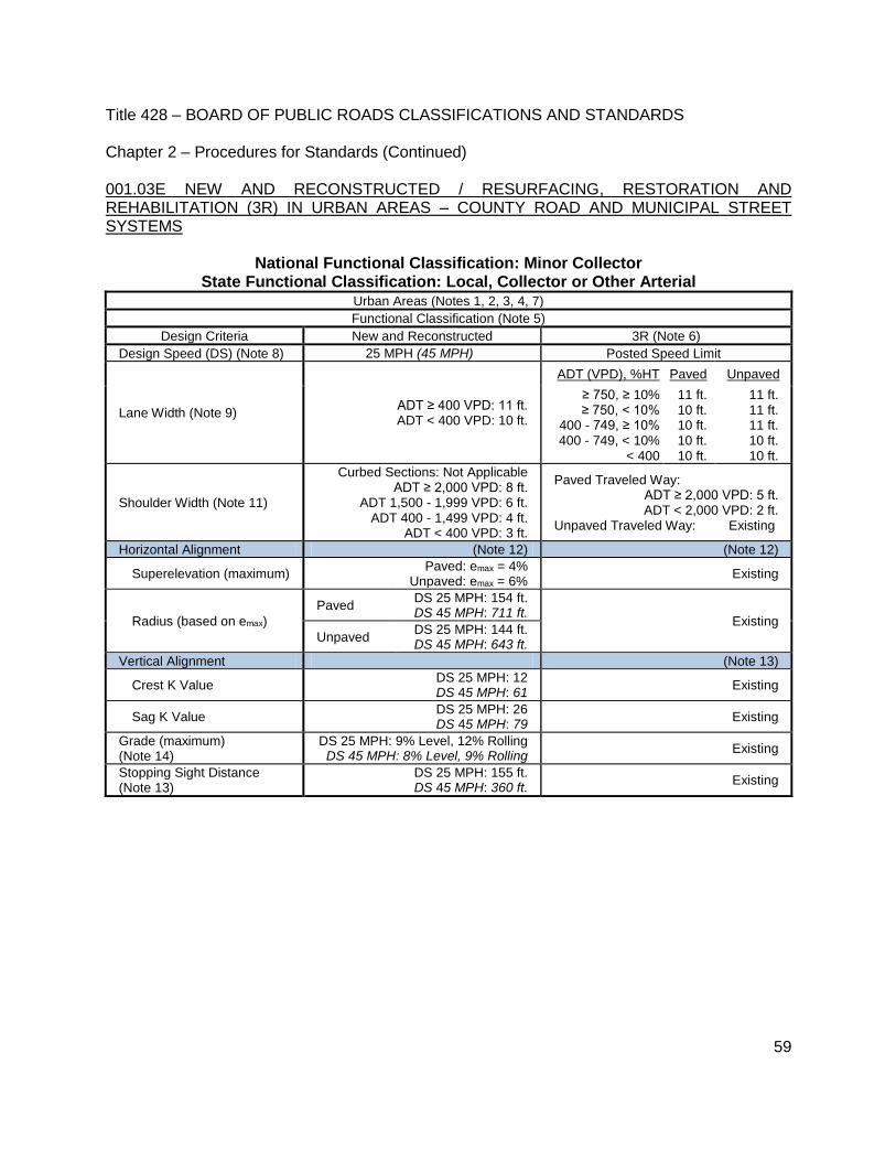
Title 428 – BOARD OF PUBLIC ROADS CLASSIFICATIONS AND STANDARDS Chapter 2 – Procedures for Standards (Continued)
59
001.03E NEW AND RECONSTRUCTED / RESURFACING, RESTORATION AND REHABILITATION (3R) IN URBAN AREAS – COUNTY ROAD AND MUNICIPAL STREET SYSTEMS
National Functional Classification: Minor Collector State Functional Classification: Local, Collector or Other Arterial
Urban Areas (Notes 1, 2, 3, 4, 7) Functional Classification (Note 5)
Design Criteria New and Reconstructed 3R (Note 6)
Design Speed (DS) (Note 8) 25 MPH (45 MPH) Posted Speed Limit
Lane Width (Note 9) ADT ≥ 400 VPD: 11 ft. ADT < 400 VPD: 10 ft.
ADT (VPD), %HT Paved Unpaved
≥ 750, ≥ 10% ≥ 750, < 10%
400 - 749, ≥ 10% 400 - 749, < 10%
< 400
11 ft. 10 ft. 10 ft. 10 ft. 10 ft.
11 ft. 11 ft. 11 ft. 10 ft. 10 ft.
Shoulder Width (Note 11)
Curbed Sections: Not Applicable ADT ≥ 2,000 VPD: 8 ft.
ADT 1,500 - 1,999 VPD: 6 ft. ADT 400 - 1,499 VPD: 4 ft.
ADT < 400 VPD: 3 ft.
Paved Traveled Way: ADT ≥ 2,000 VPD: 5 ft. ADT < 2,000 VPD: 2 ft.
Unpaved Traveled Way: Existing
Horizontal Alignment (Note 12) (Note 12)
Superelevation (maximum) Paved: emax = 4%
Unpaved: emax = 6% Existing
Radius (based on emax)
Paved DS 25 MPH: 154 ft. DS 45 MPH: 711 ft.
Existing
Unpaved DS 25 MPH: 144 ft. DS 45 MPH: 643 ft.
Vertical Alignment (Note 13)
Crest K Value DS 25 MPH: 12 DS 45 MPH: 61
Existing
Sag K Value DS 25 MPH: 26 DS 45 MPH: 79
Existing
Grade (maximum) (Note 14)
DS 25 MPH: 9% Level, 12% Rolling DS 45 MPH: 8% Level, 9% Rolling
Existing
Stopping Sight Distance (Note 13)
DS 25 MPH: 155 ft. DS 45 MPH: 360 ft.
Existing

Title 428 – BOARD OF PUBLIC ROADS CLASSIFICATIONS AND STANDARDS Chapter 2 – Procedures for Standards (Continued)
60
001.03E (Continued) NEW AND RECONSTRUCTED / RESURFACING, RESTORATION AND REHABILITATION (3R) IN URBAN AREAS – COUNTY ROAD AND MUNICIPAL STREET SYSTEMS
National Functional Classification: Minor Collector State Functional Classification: Local, Collector or Other Arterial
Urban Areas (Notes 1, 2, 3, 4, 7)
Functional Classification (Note 5)
Design Criteria New and Reconstructed 3R (Note 6)
Cross Slope (Note 15)
Lane Paved: 1.5% to 3%
Unpaved: 2% to 6% Existing
Shoulder Paved: 2% to 6%
Aggregate: 4% to 6% Turf: 6% to 8%
Existing
Horizontal Clear Zone (Note 16) BOC = Back-of-curb EOTW = Edge of Traveled Way
Sections Width
Existing
Curbed: 2 ft. from BOC or 6 ft. from EOTW, whichever is greater from EOTW
Non-Curbed:
ADT (VPD)
≥ 400 8 ft.
< 400 Nominal Shoulder Width
Vertical Clearance 14.5 ft. (Note 17) Existing
Bridges (Notes 18, 20, 21)
(letters within parentheses refer to formulas in Note 18)
Clear Bridge Width Curbed Sections
ADT ≥ 400 VPD: 25 ft. (E) ADT < 400 VPD: 23 ft. (E)
ADT ≥ 400 VPD: 23 ft. (G) ADT < 400 VPD: 21 ft. (G)
Clear Bridge Width Non-Curbed Sections
ADT ≥ 2,000 VPD: 38 ft. (A) ADT 400 - 1,999 VPD: 28 ft. (C)
ADT < 400 VPD: 24 ft. (D)
ADT ≥ 4,000 VPD: 28 ft. (C) ADT 2,000 - 3,999 VPD: 26 ft. (D)
ADT 750 - 1,999 VPD: 24 ft. (F) ADT 400 - 749 VPD: 22 ft. (H)
ADT < 400 VPD: 20 ft. (H)
Structural Capacity HL93 (Note 19) (Note 19)

Title 428 – BOARD OF PUBLIC ROADS CLASSIFICATIONS AND STANDARDS Chapter 2 – Procedures for Standards (Continued)
61
001.03F NEW AND RECONSTRUCTED / RESURFACING, RESTORATION AND REHABILITATION (3R) IN URBAN AREAS – COUNTY ROAD AND MUNICIPAL STREET SYSTEMS
National Functional Classification: Local State Functional Classification: Local, Collector or Other Arterial
Urban Areas (Notes 1, 2, 3, 4, 7) Functional Classification (Note 5)
Design Criteria New and Reconstructed 3R (Note 6)
Design Speed (DS) (Note 8) 25 MPH (45 MPH) Posted Speed Limit
Lane Width (Note 9) ADT ≥ 400 VPD: 11 ft. ADT < 400 VPD: 10 ft.
ADT (VPD), %HT Paved Unpaved
≥ 750, ≥ 10% ≥ 750, < 10%
400 - 749, ≥ 10% 400 - 749, < 10%
< 400
11 ft. 10 ft. 10 ft. 10 ft. 10 ft.
11 ft. 11 ft. 11 ft. 10 ft. 10 ft.
Shoulder Width (Note 11)
Curbed Sections: Not Applicable ADT ≥ 2,000 VPD: 8 ft.
ADT 1,500 - 1,999 VPD: 6 ft. ADT 400 - 1,499 VPD: 4 ft.
ADT < 400 VPD: 3 ft.
Paved Traveled Way ADT ≥ 2,000 VPD: 5 ft. ADT < 2,000 VPD: 2 ft.
Unpaved Traveled Way: Existing
Horizontal Alignment (Note 12) (Note 12)
Superelevation (maximum) Paved: emax = 4%
Unpaved: emax = 6% Existing
Radius (based on emax)
Paved DS 25 MPH: 154 ft. DS 45 MPH: 711 ft.
Existing
Unpaved DS 25 MPH: 144 ft. DS 45 MPH: 643 ft.
Vertical Alignment (Note 13)
Crest K Value DS 25 MPH: 12 DS 45 MPH: 61
Existing
Sag K Value DS 25 MPH: 26 DS 45 MPH: 79
Existing
Grade (maximum) (Note 14)
DS 25 MPH: 9% Level, 12% Rolling DS 45 MPH: 8% Level, 9% Rolling
Existing
Stopping Sight Distance (Note 13)
DS 25 MPH: 155 ft. DS 45 MPH: 360 ft.
Existing

Title 428 – BOARD OF PUBLIC ROADS CLASSIFICATIONS AND STANDARDS Chapter 2 – Procedures for Standards (Continued)
62
001.03F (Continued) NEW AND RECONSTRUCTED / RESURFACING, RESTORATION AND REHABILITATION (3R) IN URBAN AREAS – COUNTY ROAD AND MUNICIPAL STREET SYSTEMS
National Functional Classification: Local State Functional Classification: Local, Collector or Other Arterial
Urban Areas (Notes 1, 2, 3, 4, 7)
Functional Classification (Note 5)
Design Criteria New and Reconstructed 3R (Note 6)
Cross Slope (Note 15)
Lane Paved: 1.5% to 3%
Unpaved: 2% to 6% Existing
Shoulder Paved: 2% to 6%
Aggregate: 4% to 6% Turf: 6% to 8%
Existing
Horizontal Clear Zone (Note 16) BOC = Back-of-curb EOTW = Edge of Traveled Way
Sections Width
Existing
Curbed: 2 ft. from BOC or 6 ft. from EOTW, whichever is greater from EOTW
Non-Curbed:
ADT (VPD)
≥ 400 8 ft.
< 400 Nominal Shoulder Width
Vertical Clearance 14.5 ft. (Note 17) Existing
Bridges (Notes 18, 20, 21)
(letters within parentheses refer to formulas in Note 18)
Clear Bridge Width Curbed Sections
ADT ≥ 400 VPD: 25 ft. (E) ADT < 400 VPD: 23 ft. (E)
ADT ≥ 400 VPD: 23 ft. (G) ADT < 400 VPD: 21 ft. (G)
Clear Bridge Width Non-Curbed Sections
ADT ≥ 2,000 VPD: 38 ft. (A) ADT 400 - 1,999 VPD: 28 ft. (C)
ADT < 400 VPD: 24 ft. (D)
ADT ≥ 4,000 VPD: 28 ft. (C) ADT 2,000 - 3,999 VPD: 26 ft. (D)
ADT 750 - 1,999 VPD: 24 ft. (F) ADT 400 - 749 VPD: 22 ft. (H)
ADT < 400 VPD: 20 ft. (H)
Structural Capacity HL93 (Note 19) (Note 19)
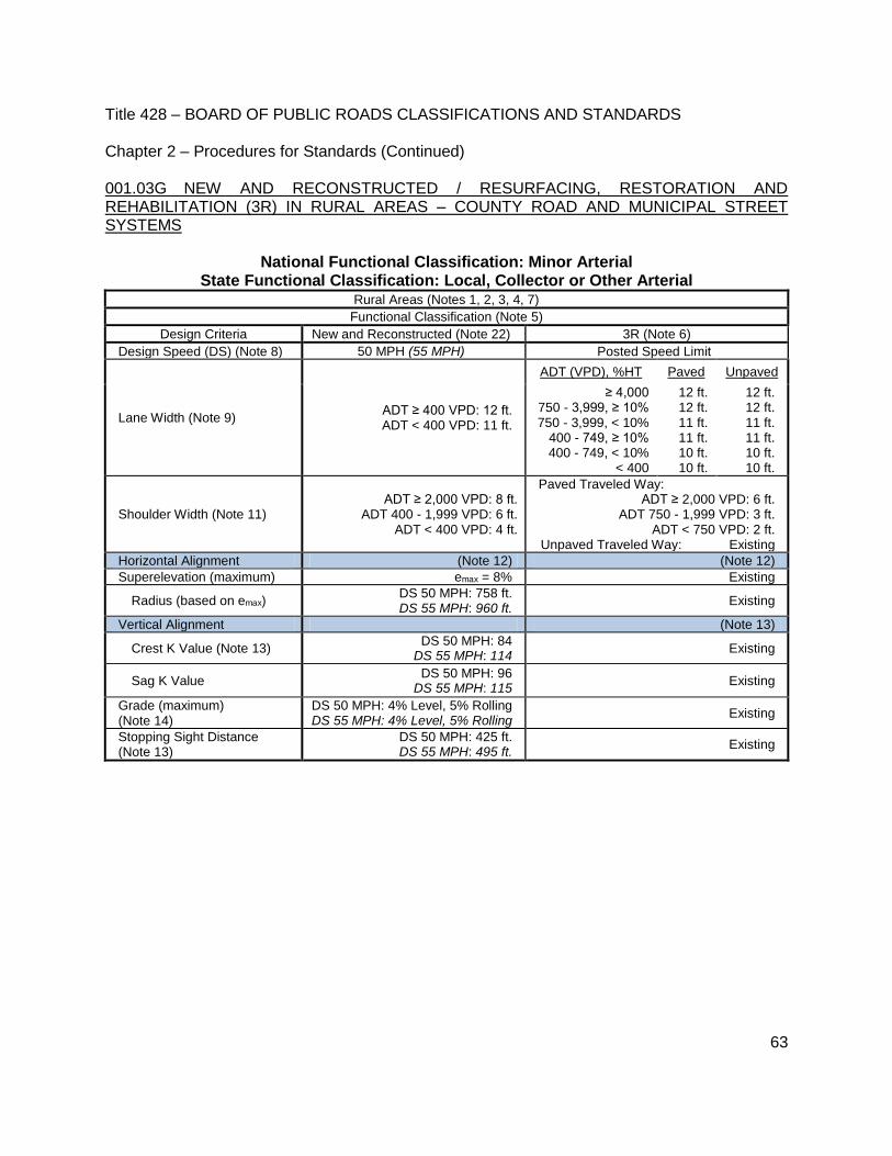
Title 428 – BOARD OF PUBLIC ROADS CLASSIFICATIONS AND STANDARDS Chapter 2 – Procedures for Standards (Continued)
63
001.03G NEW AND RECONSTRUCTED / RESURFACING, RESTORATION AND REHABILITATION (3R) IN RURAL AREAS – COUNTY ROAD AND MUNICIPAL STREET SYSTEMS
National Functional Classification: Minor Arterial State Functional Classification: Local, Collector or Other Arterial
Rural Areas (Notes 1, 2, 3, 4, 7) Functional Classification (Note 5)
Design Criteria New and Reconstructed (Note 22) 3R (Note 6)
Design Speed (DS) (Note 8) 50 MPH (55 MPH) Posted Speed Limit
Lane Width (Note 9) ADT ≥ 400 VPD: 12 ft. ADT < 400 VPD: 11 ft.
ADT (VPD), %HT Paved Unpaved
≥ 4,000 750 - 3,999, ≥ 10% 750 - 3,999, < 10%
400 - 749, ≥ 10% 400 - 749, < 10%
< 400
12 ft. 12 ft. 11 ft. 11 ft. 10 ft. 10 ft.
12 ft. 12 ft. 11 ft. 11 ft. 10 ft. 10 ft.
Shoulder Width (Note 11) ADT ≥ 2,000 VPD: 8 ft.
ADT 400 - 1,999 VPD: 6 ft. ADT < 400 VPD: 4 ft.
Paved Traveled Way: ADT ≥ 2,000 VPD: 6 ft.
ADT 750 - 1,999 VPD: 3 ft. ADT < 750 VPD: 2 ft.
Unpaved Traveled Way: Existing
Horizontal Alignment (Note 12) (Note 12)
Superelevation (maximum) emax = 8% Existing
Radius (based on emax) DS 50 MPH: 758 ft. DS 55 MPH: 960 ft.
Existing
Vertical Alignment (Note 13)
Crest K Value (Note 13) DS 50 MPH: 84
DS 55 MPH: 114 Existing
Sag K Value DS 50 MPH: 96
DS 55 MPH: 115 Existing
Grade (maximum) (Note 14)
DS 50 MPH: 4% Level, 5% Rolling DS 55 MPH: 4% Level, 5% Rolling
Existing
Stopping Sight Distance (Note 13)
DS 50 MPH: 425 ft. DS 55 MPH: 495 ft.
Existing

Title 428 – BOARD OF PUBLIC ROADS CLASSIFICATIONS AND STANDARDS Chapter 2 – Procedures for Standards (Continued)
64
001.03G (Continued) NEW AND RECONSTRUCTED / RESURFACING, RESTORATION AND REHABILITATION (3R) IN RURAL AREAS – COUNTY ROAD AND MUNICIPAL STREET SYSTEMS
National Functional Classification: Minor Arterial State Functional Classification: Local, Collector or Other Arterial
Rural Areas (Notes 1, 2, 3, 4, 7)
Functional Classification (Note 5)
Design Criteria New and Reconstructed (Note 22) 3R (Note 6)
Cross Slope (Note 15)
Lane Paved: 1.5% to 2% Existing
Shoulder Paved: 2% to 6%
Aggregate: 4% to 6% Turf: 6% to 8%
Existing
Horizontal Clear Zone (Note 16)
ADT (VPD)
Width, ft.
Existing
DS 50/55 MPH
1V:6H 1V:4H
≥ 6,000 20/22 24/26
1,500 - 5,999 16/20 20/24
750 - 1,499 14/16 16/20
< 750 10/12 12/14
Vertical Clearance 16 ft. (Note 17) Existing
Bridges (Notes 18, 20, 21)
(letters within parentheses refer to formulas in Note 18)
Clear Bridge Width ADT ≥ 2,000 VPD: 40 ft. (A)
ADT 400 - 1,999 VPD: 36 ft. (A) ADT < 400 VPD: 30 ft. (A)
ADT ≥ 4,000 VPD: 30 ft. (C) ADT 2,000 - 3,999 VPD: 28 ft. (D)
ADT 750 - 1,999 VPD: 26 ft. (F) ADT 400 - 749 VPD: 24 ft. (F)
ADT < 400 VPD: 22 ft. (F)
Structural Capacity HL93 (Note 19) (Note 19)
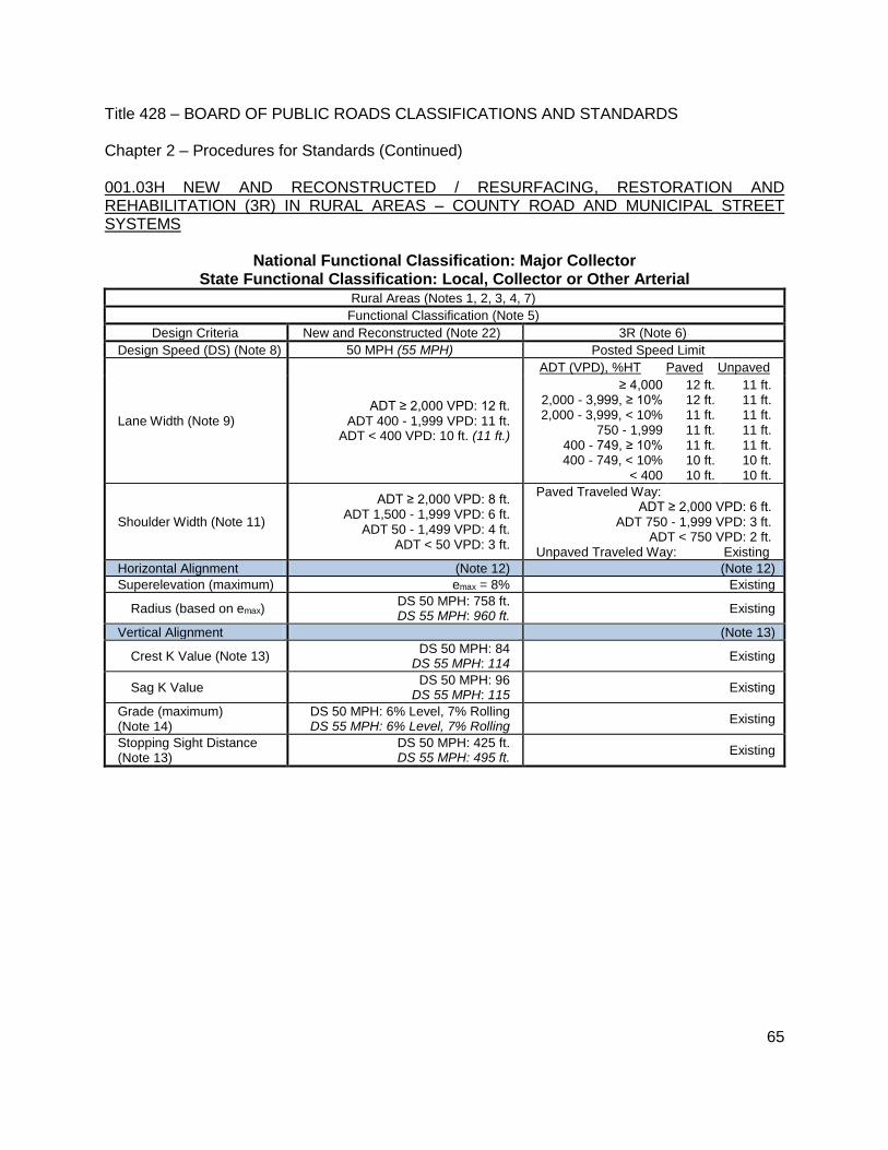
Title 428 – BOARD OF PUBLIC ROADS CLASSIFICATIONS AND STANDARDS Chapter 2 – Procedures for Standards (Continued)
65
001.03H NEW AND RECONSTRUCTED / RESURFACING, RESTORATION AND REHABILITATION (3R) IN RURAL AREAS – COUNTY ROAD AND MUNICIPAL STREET SYSTEMS
National Functional Classification: Major Collector State Functional Classification: Local, Collector or Other Arterial
Rural Areas (Notes 1, 2, 3, 4, 7) Functional Classification (Note 5)
Design Criteria New and Reconstructed (Note 22) 3R (Note 6)
Design Speed (DS) (Note 8) 50 MPH (55 MPH) Posted Speed Limit
Lane Width (Note 9) ADT ≥ 2,000 VPD: 12 ft.
ADT 400 - 1,999 VPD: 11 ft. ADT < 400 VPD: 10 ft. (11 ft.)
ADT (VPD), %HT Paved Unpaved
≥ 4,000 2,000 - 3,999, ≥ 10% 2,000 - 3,999, < 10%
750 - 1,999 400 - 749, ≥ 10% 400 - 749, < 10%
< 400
12 ft. 12 ft. 11 ft. 11 ft. 11 ft. 10 ft. 10 ft.
11 ft. 11 ft. 11 ft. 11 ft. 11 ft. 10 ft. 10 ft.
Shoulder Width (Note 11)
ADT ≥ 2,000 VPD: 8 ft. ADT 1,500 - 1,999 VPD: 6 ft.
ADT 50 - 1,499 VPD: 4 ft. ADT < 50 VPD: 3 ft.
Paved Traveled Way: ADT ≥ 2,000 VPD: 6 ft.
ADT 750 - 1,999 VPD: 3 ft. ADT < 750 VPD: 2 ft.
Unpaved Traveled Way: Existing
Horizontal Alignment (Note 12) (Note 12)
Superelevation (maximum) emax = 8% Existing
Radius (based on emax) DS 50 MPH: 758 ft. DS 55 MPH: 960 ft.
Existing
Vertical Alignment (Note 13)
Crest K Value (Note 13) DS 50 MPH: 84
DS 55 MPH: 114 Existing
Sag K Value DS 50 MPH: 96
DS 55 MPH: 115 Existing
Grade (maximum) (Note 14)
DS 50 MPH: 6% Level, 7% Rolling DS 55 MPH: 6% Level, 7% Rolling
Existing
Stopping Sight Distance (Note 13)
DS 50 MPH: 425 ft. DS 55 MPH: 495 ft.
Existing

Title 428 – BOARD OF PUBLIC ROADS CLASSIFICATIONS AND STANDARDS Chapter 2 – Procedures for Standards (Continued)
66
001.03H (Continued) NEW AND RECONSTRUCTED / RESURFACING, RESTORATION AND REHABILITATION (3R) IN RURAL AREAS – COUNTY ROAD AND MUNICIPAL STREET SYSTEMS
National Functional Classification: Major Collector State Functional Classification: Local, Collector or Other Arterial
Rural Areas (Notes 1, 2, 3, 4, 7)
Functional Classification (Note 5)
Design Criteria New and Reconstructed (Note 22) 3R (Note 6)
Cross Slope (Note 15)
Lane Paved: 1.5% to 2%
Unpaved: 2% to 6% Existing
Shoulder Paved: 2% to 6%
Aggregate: 4% to 6% Turf: 6% to 8%
Existing
Horizontal Clear Zone (Note 16)
ADT (VPD)
Width, ft.
Existing
DS 50/55 MPH
1V:6H 1V:4H
≥ 6,000 20/22 24/26
1,500 - 5,999 16/20 20/24
750 - 1,499 14/16 16/20
250 - 749 10/12 12/14
50 - 249 8/10 10/12
< 50 Nominal Shoulder Width
Vertical Clearance 14.5 ft. (Note 17) Existing
Bridges (Notes 18, 20, 21)
(letters within parentheses refer to formulas in Note 18)
Clear Bridge Width
ADT ≥ 2,000 VPD: 40 ft. (A) ADT 1,500 - 1,999 VPD: 32 ft. (B)
ADT 400 - 1,499 VPD: 28 ft. (C) ADT < 400 VPD: 24 ft. (D)
ADT ≥ 4,000 VPD: 30 ft. (C) ADT 2,000 - 3,999 VPD: 28 ft. (D) ADT 1,500 - 1,999 VPD: 26 ft. (F)
ADT 750 - 1,499 VPD: 24 ft. (F) ADT 400 - 749 VPD: 22 ft. (H)
ADT < 400 VPD: 20 ft. (H)
Structural Capacity HL93 (Note 19) (Note 19)

Title 428 – BOARD OF PUBLIC ROADS CLASSIFICATIONS AND STANDARDS Chapter 2 – Procedures for Standards (Continued)
67
001.03I NEW AND RECONSTRUCTED / RESURFACING, RESTORATION AND REHABILITATION (3R) IN RURAL AREAS – COUNTY ROAD AND MUNICIPAL STREET SYSTEMS
National Functional Classification: Minor Collector State Functional Classification: Local, Collector or Other Arterial
Rural Areas (Notes 1, 2, 3, 4, 7) Functional Classification (Note 5)
Design Criteria New and Reconstructed (Notes 10, 22)
3R (Note 6)
Design Speed (DS) (Notes 8, 12, 13)
50 MPH (55 MPH) Posted Speed Limit
Lane Width (Note 9) ADT ≥ 2,000 VPD: 12 ft.
ADT 400 - 1,999 VPD: 11 ft. ADT < 400 VPD: 10 ft. (11 ft.)
ADT (VPD), %HT Paved Unpaved
≥ 4,000 2,000 - 3,999, ≥ 10% 2,000 - 3,999, < 10%
750 - 1,999 400 - 749, ≥ 10% 400 - 749, < 10%
< 400
12 ft. 12 ft. 11 ft. 11 ft. 11 ft. 10 ft. 10 ft.
11 ft. 11 ft. 11 ft. 11 ft. 11 ft. 10 ft. 10 ft.
Shoulder Width (Note 11)
ADT ≥ 2,000 VPD: 8 ft. ADT 1,500 - 1,999 VPD: 6 ft.
ADT 50 - 1,499 VPD: 4 ft. ADT < 50 VPD: 3 ft.
Paved Traveled Way: ADT ≥ 2,000 VPD: 6 ft.
ADT 750 - 1,999 VPD: 3 ft. ADT < 750 VPD: 2 ft.
Unpaved Traveled Way: Existing
Horizontal Alignment (Note 12) (Note 12)
Superelevation (maximum) emax = 8% Existing
Radius (based on emax) DS 50 MPH: 758 ft. DS 55 MPH: 960 ft.
Existing
Vertical Alignment (Note 13) (Note 13)
Crest K Value DS 50 MPH: 84
DS 55 MPH: 114 Existing
Sag K Value DS 50 MPH: 96
DS 55 MPH: 115 Existing
Grade (maximum) (Note 14)
DS 50 MPH: 6% Level, 7% Rolling DS 55 MPH: 6% Level, 7% Rolling
Existing
Stopping Sight Distance (Notes 12, 13)
DS 50 MPH: 425 ft. DS 55 MPH: 495 ft.
Existing

Title 428 – BOARD OF PUBLIC ROADS CLASSIFICATIONS AND STANDARDS Chapter 2 – Procedures for Standards (Continued)
68
001.03I (Continued) NEW AND RECONSTRUCTED / RESURFACING, RESTORATION AND REHABILITATION (3R) IN RURAL AREAS – COUNTY ROAD AND MUNICIPAL STREET SYSTEMS
National Functional Classification: Minor Collector State Functional Classification: Local, Collector or Other Arterial
Rural Areas (Notes 1, 2, 3, 4, 7)
Functional Classification (Note 5)
Design Criteria New and Reconstructed (Notes 10, 22) 3R (Note 6)
Cross Slope (Note 15)
Lane Paved: 1.5% to 2%
Unpaved: 2% to 6% Existing
Shoulder Paved: 2% to 6%
Aggregate: 4% to 6% Turf: 6% to 8%
Existing
Horizontal Clear Zone (Note 16)
ADT (VPD)
Width, ft.
Existing
DS 50/55 MPH
1V:6H 1V:4H
≥ 6,000 20/22 24/26
1,500 - 5,999 16/20 20/24
750 - 1,499 14/16 16/20
400 - 749 10/12 12/14
< 400 Nominal Shoulder Width
Vertical Clearance 14.5 ft. (Note 17) Existing
Bridges (Notes 18, 20, 21)
(letters within parentheses refer to formulas in Note 18)
Clear Bridge Width
ADT ≥ 2,000 VPD: 40 ft. (A) ADT 1,500 - 1,999 VPD: 30 ft. (B)
ADT 400 - 1,499 VPD: 28 ft. (C) ADT < 400 VPD: 24 ft. (D)
ADT ≥ 4,000 VPD: 30 ft. (C) ADT 2,000 - 3,999 VPD: 28 ft. (D)
ADT 750 - 1,999 VPD: 24 ft. (F) ADT 400 - 749 VPD: 22 ft. (H)
ADT < 400 VPD: 20 ft. (H)
Structural Capacity HL93 (Note 19) (Note 19)
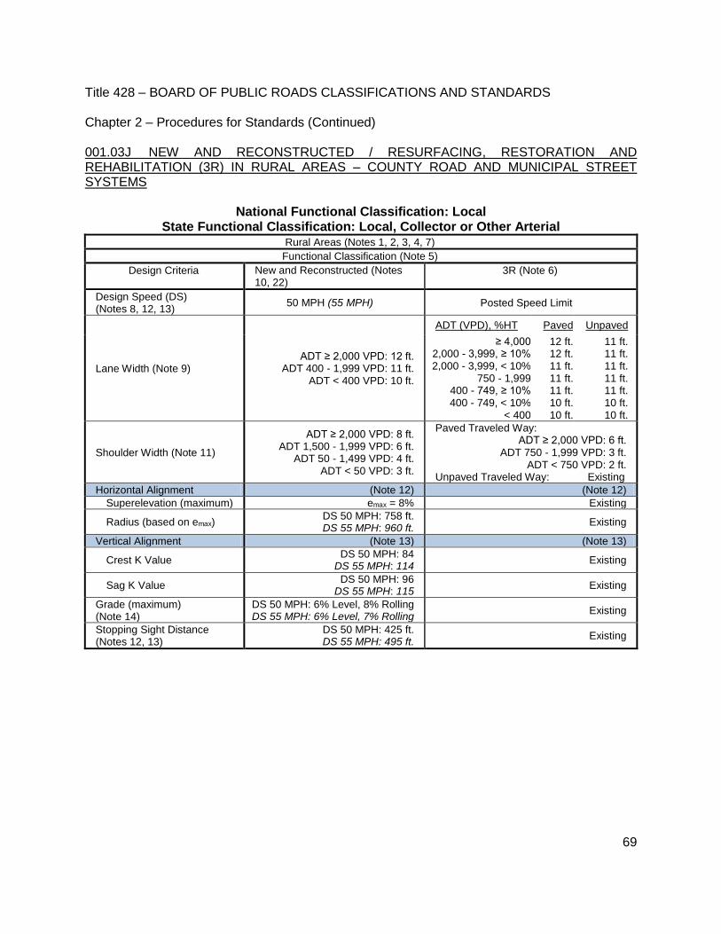
Title 428 – BOARD OF PUBLIC ROADS CLASSIFICATIONS AND STANDARDS Chapter 2 – Procedures for Standards (Continued)
69
001.03J NEW AND RECONSTRUCTED / RESURFACING, RESTORATION AND REHABILITATION (3R) IN RURAL AREAS – COUNTY ROAD AND MUNICIPAL STREET SYSTEMS
National Functional Classification: Local State Functional Classification: Local, Collector or Other Arterial
Rural Areas (Notes 1, 2, 3, 4, 7) Functional Classification (Note 5)
Design Criteria New and Reconstructed (Notes 10, 22)
3R (Note 6)
Design Speed (DS) (Notes 8, 12, 13)
50 MPH (55 MPH) Posted Speed Limit
Lane Width (Note 9) ADT ≥ 2,000 VPD: 12 ft.
ADT 400 - 1,999 VPD: 11 ft. ADT < 400 VPD: 10 ft.
ADT (VPD), %HT Paved Unpaved
≥ 4,000 2,000 - 3,999, ≥ 10% 2,000 - 3,999, < 10%
750 - 1,999 400 - 749, ≥ 10% 400 - 749, < 10%
< 400
12 ft. 12 ft. 11 ft. 11 ft. 11 ft. 10 ft. 10 ft.
11 ft. 11 ft. 11 ft. 11 ft. 11 ft. 10 ft. 10 ft.
Shoulder Width (Note 11)
ADT ≥ 2,000 VPD: 8 ft. ADT 1,500 - 1,999 VPD: 6 ft.
ADT 50 - 1,499 VPD: 4 ft. ADT < 50 VPD: 3 ft.
Paved Traveled Way: ADT ≥ 2,000 VPD: 6 ft.
ADT 750 - 1,999 VPD: 3 ft. ADT < 750 VPD: 2 ft.
Unpaved Traveled Way: Existing
Horizontal Alignment (Note 12) (Note 12)
Superelevation (maximum) emax = 8% Existing
Radius (based on emax) DS 50 MPH: 758 ft. DS 55 MPH: 960 ft.
Existing
Vertical Alignment (Note 13) (Note 13)
Crest K Value DS 50 MPH: 84
DS 55 MPH: 114 Existing
Sag K Value DS 50 MPH: 96
DS 55 MPH: 115 Existing
Grade (maximum) (Note 14)
DS 50 MPH: 6% Level, 8% Rolling DS 55 MPH: 6% Level, 7% Rolling
Existing
Stopping Sight Distance (Notes 12, 13)
DS 50 MPH: 425 ft. DS 55 MPH: 495 ft.
Existing

Title 428 – BOARD OF PUBLIC ROADS CLASSIFICATIONS AND STANDARDS Chapter 2 – Procedures for Standards (Continued)
70
001.03J (Continued) NEW AND RECONSTRUCTED / RESURFACING, RESTORATION AND REHABILITATION (3R) IN RURAL AREAS – COUNTY ROAD AND MUNICIPAL STREET SYSTEMS
National Functional Classification: Local State Functional Classification: Local, Collector or Other Arterial
Rural Areas (Notes 1, 2, 3, 4, 7)
Functional Classification (Note 5)
Design Criteria New and Reconstructed (Notes 10, 22) 3R (Note 6)
Cross Slope (Note 15)
Lane Paved: 1.5% to 2%
Unpaved: 2% to 6% Existing
Shoulder Paved: 2% to 6%
Aggregate: 4% to 6% Turf: 6% to 8%
Existing
Horizontal Clear Zone (Note 16)
ADT (VPD)
Width, ft.
Existing
DS 50/55 MPH
1V:6H 1V:4H
≥ 6,000 20/22 24/26
1,500 - 5,999 16/20 20/24
750 - 1,499 14/16 16/20
400 - 749 10/12 12/14
< 400 Nominal Shoulder Width
Vertical Clearance 14.5 ft. (Note 17) Existing
Bridges (Notes 18, 20, 21)
(letters within parentheses refer to formulas in Note 18)
Clear Bridge Width ADT ≥ 2,000 VPD: 40 ft. (A)
ADT 400 - 1,999 VPD: 38 ft. (C) ADT < 400 VPD: 24 ft. (D)
ADT ≥ 4,000 VPD: 30 ft. (C) ADT 2,000 - 3,999 VPD: 28 ft. (D)
ADT 750 - 1,999 VPD: 24 ft. (F) ADT 400 - 749 VPD: 22 ft. (H)
ADT < 400 VPD: 20 ft. (H)
Structural Capacity HL93 (Note 19) (Note 19)

Title 428 – BOARD OF PUBLIC ROADS CLASSIFICATIONS AND STANDARDS Chapter 2 – Procedures for Standards (Continued)
71
001.03K NEW AND RECONSTRUCTED / RESURFACING, RESTORATION AND REHABILITATION (3R) SCENIC-RECREATION ROADS IN RURAL AREAS – COUNTY ROAD SYSTEM
National Functional Classification: Minor Arterial State Functional Classification: Scenic-Recreation-Local, Collector or Other Arterial
Rural Areas (Notes 1, 2, 3, 4, 7) Functional Classification (Note 5)
Design Criteria New and Reconstructed (Note 22) 3R (Note 6)
Design Speed (DS) (Note 8) 50 MPH (55 MPH) Posted Speed Limit
Lane Width (Note 9) ADT ≥ 1,500 VPD: 12 ft. ADT < 1,499 VPD: 11 ft.
ADT (VPD), %HT Paved Unpaved
≥ 4,000 750 - 3,999, ≥ 10% 750 - 3,999, < 10%
400 - 749, ≥ 10% 400 - 749, < 10%
< 400
12 ft. 12 ft. 11 ft. 11 ft. 10 ft. 10 ft.
12 ft. 12 ft. 12 ft. 12 ft. 11 ft. 10 ft.
Shoulder Width (Note 11) ADT ≥ 2,000 VPD: 8 ft.
ADT 750 - 1,999 VPD: 6 ft. ADT < 750 VPD: 4 ft.
Paved Traveled Way: ADT ≥ 2,000 VPD: 6 ft.
ADT 750 - 1,999 VPD: 3 ft. ADT < 750 VPD: 2 ft.
Unpaved Traveled Way: Existing
Horizontal Alignment (Note 12) (Note 12)
Superelevation (maximum) emax = 8% Existing
Radius (based on emax) DS 50 MPH: 758 ft. DS 55 MPH: 960 ft.
Existing
Vertical Alignment (Note 13)
Crest K Value (Note 13) DS 50 MPH: 84
DS 55 MPH: 114 Existing
Sag K Value DS 50 MPH: 96
DS 55 MPH: 115 Existing
Grade (maximum) (Note 14)
DS 50 MPH: 4% Level, 5% Rolling DS 55 MPH: 4% Level, 5% Rolling
Existing
Stopping Sight Distance (Note 13)
DS 50 MPH: 425 ft. DS 55 MPH: 495 ft.
Existing
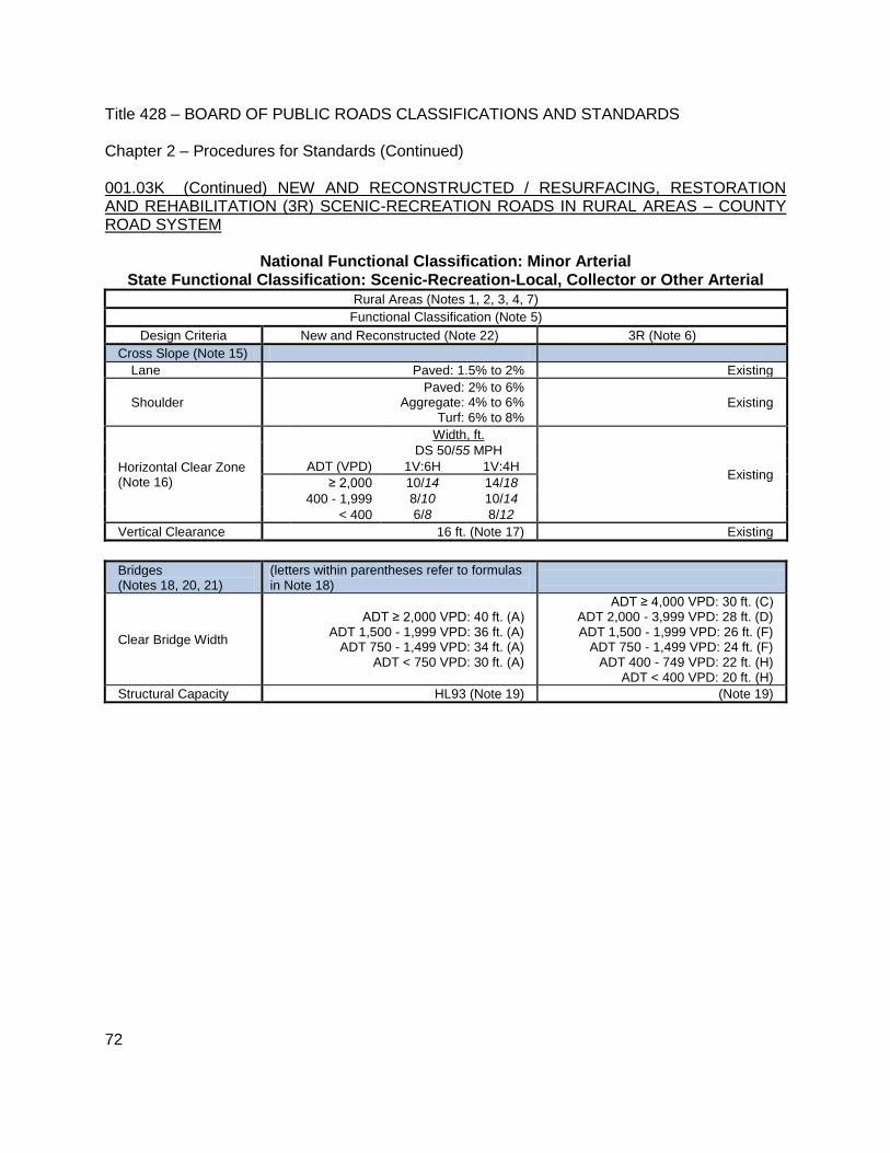
Title 428 – BOARD OF PUBLIC ROADS CLASSIFICATIONS AND STANDARDS Chapter 2 – Procedures for Standards (Continued)
72
001.03K (Continued) NEW AND RECONSTRUCTED / RESURFACING, RESTORATION AND REHABILITATION (3R) SCENIC-RECREATION ROADS IN RURAL AREAS – COUNTY ROAD SYSTEM
National Functional Classification: Minor Arterial State Functional Classification: Scenic-Recreation-Local, Collector or Other Arterial
Rural Areas (Notes 1, 2, 3, 4, 7)
Functional Classification (Note 5)
Design Criteria New and Reconstructed (Note 22) 3R (Note 6)
Cross Slope (Note 15)
Lane Paved: 1.5% to 2% Existing
Shoulder Paved: 2% to 6%
Aggregate: 4% to 6% Turf: 6% to 8%
Existing
Horizontal Clear Zone (Note 16)
ADT (VPD)
Width, ft.
Existing
DS 50/55 MPH
1V:6H 1V:4H
≥ 2,000 10/14 14/18
400 - 1,999 8/10 10/14
< 400 6/8 8/12
Vertical Clearance 16 ft. (Note 17) Existing
Bridges (Notes 18, 20, 21)
(letters within parentheses refer to formulas in Note 18)
Clear Bridge Width
ADT ≥ 2,000 VPD: 40 ft. (A) ADT 1,500 - 1,999 VPD: 36 ft. (A)
ADT 750 - 1,499 VPD: 34 ft. (A) ADT < 750 VPD: 30 ft. (A)
ADT ≥ 4,000 VPD: 30 ft. (C) ADT 2,000 - 3,999 VPD: 28 ft. (D) ADT 1,500 - 1,999 VPD: 26 ft. (F)
ADT 750 - 1,499 VPD: 24 ft. (F) ADT 400 - 749 VPD: 22 ft. (H)
ADT < 400 VPD: 20 ft. (H)
Structural Capacity HL93 (Note 19) (Note 19)

Title 428 – BOARD OF PUBLIC ROADS CLASSIFICATIONS AND STANDARDS Chapter 2 – Procedures for Standards (Continued)
73
001.03L NEW AND RECONSTRUCTED / RESURFACING, RESTORATION AND REHABILITATION (3R) SCENIC-RECREATION ROADS IN RURAL AREAS – COUNTY ROAD SYSTEM
National Functional Classification: Major Collector State Functional Classification: Scenic-Recreation-Local, Collector or Other Arterial
Rural Areas (Notes 1, 2, 3, 4, 7) Functional Classification (Note 5)
Design Criteria New and Reconstructed (Note 22) 3R (Note 6)
Design Speed (DS) (Note 8) 50 MPH (55 MPH) Posted Speed Limit
Lane Width (Note 9) ADT ≥ 2,000 VPD: 12 ft.
ADT 400 - 1,999 VPD: 11 ft. ADT < 400 VPD: 10 ft. (11 ft.)
ADT (VPD), %HT Paved Unpaved
≥ 4,000 2,000 - 3,999, ≥ 10% 2,000 - 3,999, < 10%
750 - 1,999 400 - 749, ≥ 10% 400 - 749, < 10%
< 400
12 ft. 12 ft. 11 ft. 11 ft. 11 ft. 10 ft. 10 ft.
11 ft. 11 ft. 11 ft. 11 ft. 11 ft. 10 ft. 10 ft.
Shoulder Width (Note 11)
ADT ≥ 2,000 VPD: 8 ft. ADT 1,500 - 1,999 VPD: 6 ft.
ADT 400 - 1,499 VPD: 4 ft. ADT < 400 VPD: 2 ft.
Paved Traveled Way: ADT ≥ 2,000 VPD: 6 ft.
ADT 750 - 1,999 VPD: 3 ft. ADT < 750 VPD: 2 ft.
Unpaved Traveled Way: Existing
Horizontal Alignment (Note 12) (Note 12)
Superelevation (maximum) emax = 8% Existing
Radius (based on emax) DS 50 MPH: 758 ft. DS 55 MPH: 960 ft.
Existing
Vertical Alignment (Note 13)
Crest K Value (Note 13) DS 50 MPH: 84
DS 55 MPH: 114 Existing
Sag K Value DS 50 MPH: 96
DS 55 MPH: 115 Existing
Grade (maximum) (Note 14)
DS 50 MPH: 6% Level, 7% Rolling DS 55 MPH: 6% Level, 7% Rolling
Existing
Stopping Sight Distance (Note 13)
DS 50 MPH: 425 ft. DS 55 MPH: 495 ft.
Existing

Title 428 – BOARD OF PUBLIC ROADS CLASSIFICATIONS AND STANDARDS Chapter 2 – Procedures for Standards (Continued)
74
001.03L (Continued) NEW AND RECONSTRUCTED / RESURFACING, RESTORATION AND REHABILITATION (3R) SCENIC-RECREATION ROADS IN RURAL AREAS – COUNTY ROAD SYSTEM
National Functional Classification: Major Collector State Functional Classification: Scenic-Recreation-Local, Collector or Other Arterial
Rural Areas (Notes 1, 2, 3, 4, 7)
Functional Classification (Note 5)
Design Criteria New and Reconstructed (Note 22) 3R (Note 6)
Cross Slope (Note 15)
Lane Paved: 1.5% to 2%
Unpaved: 2% to 6% Existing
Shoulder Paved: 2% to 6%
Aggregate: 4% to 6% Turf: 6% to 8%
Existing
Horizontal Clear Zone (Note 16)
ADT (VPD)
Width, ft.
Existing
DS 50/55 MPH
1V:6H 1V:4H
≥ 2,000 10/14 14/18
400 - 1,999 8/10 10/14
250-399 6/8 8/12
< 250 Nominal Shoulder Width
Vertical Clearance 14.5 ft. (Note 17) Existing
Bridges (Notes 18, 20, 21)
(letters within parentheses refer to formulas in Note 18)
Clear Bridge Width
ADT ≥ 2,000 VPD: 40 ft. (A) ADT 1,500 - 1,999 VPD: 30 ft. (B)
ADT 400 - 1,499 VPD: 28 ft. (C) ADT < 400 VPD: 24 ft. (D)
ADT ≥ 4,000 VPD: 30 ft. (C) ADT 2,000 - 3,999 VPD: 28 ft. (D)
ADT 750 - 1,999 VPD: 24 ft. (F) ADT 400 - 749 VPD: 22 ft. (H)
ADT < 400 VPD: 20 ft. (H)
Structural Capacity HL93 (Note 19) (Note 19)

Title 428 – BOARD OF PUBLIC ROADS CLASSIFICATIONS AND STANDARDS Chapter 2 – Procedures for Standards (Continued)
75
001.03M NEW AND RECONSTRUCTED / RESURFACING, RESTORATION AND REHABILITATION (3R) SCENIC-RECREATION ROADS IN RURAL AREAS – COUNTY ROAD SYSTEM
National Functional Classification: Minor Collector State Functional Classification: Scenic-Recreation-Local, Collector or Other Arterial
Rural Areas (Notes 1, 2, 3, 4, 7) Functional Classification (Note 5)
Design Criteria New and Reconstructed (Notes 10, 22)
3R (Note 6)
Design Speed (DS) (Notes 8, 12, 13)
50 MPH (55 MPH) Posted Speed Limit
Lane Width (Note 9) ADT ≥ 2,000 VPD: 12 ft.
ADT 400 - 1,999 VPD: 11 ft. ADT < 400 VPD: 10 ft. (11 ft.)
ADT (VPD), %HT Paved Unpaved
≥ 4,000 2,000 - 3,999, ≥ 10% 2,000 - 3,999, < 10%
750 - 1,999 400 - 749, ≥ 10% 400 - 749, < 10%
< 400
12 ft. 12 ft. 11 ft. 11 ft. 11 ft. 10 ft. 10 ft.
11 ft. 11 ft. 11 ft. 11 ft. 11 ft. 10 ft. 10 ft.
Shoulder Width (Note 11)
ADT ≥ 2,000 VPD: 8 ft. ADT 1,500 - 1,999 VPD: 6 ft.
ADT 400 - 1,499 VPD: 4 ft. ADT < 400 VPD: 2 ft.
Paved Traveled Way: ADT ≥ 2,000 VPD: 6 ft.
ADT 750 - 1,999 VPD: 3 ft. ADT < 750 VPD: 2 ft.
Unpaved Traveled Way: Existing
Horizontal Alignment (Note 12) (Note 12)
Superelevation (maximum) emax = 8% Existing
Radius (based on emax) DS 50 MPH: 758 ft. DS 55 MPH: 960 ft.
Existing
Vertical Alignment (Note 13) (Note 13)
Crest K Value DS 50 MPH: 84
DS 55 MPH: 114 Existing
Sag K Value DS 50 MPH: 96
DS 55 MPH: 115 Existing
Grade (maximum) (Note 14)
DS 50 MPH: 6% Level, 7% Rolling DS 55 MPH: 6% Level, 7% Rolling
Existing
Stopping Sight Distance (Notes 12, 13)
DS 50 MPH: 425 ft. DS 55 MPH: 495 ft.
Existing

Title 428 – BOARD OF PUBLIC ROADS CLASSIFICATIONS AND STANDARDS Chapter 2 – Procedures for Standards (Continued)
76
001.03M (Continued) NEW AND RECONSTRUCTED / RESURFACING, RESTORATION AND REHABILITATION (3R) SCENIC-RECREATION ROADS IN RURAL AREAS – COUNTY ROAD SYSTEM
National Functional Classification: Minor Collector State Functional Classification: Scenic-Recreation-Local, Collector or Other Arterial
Rural Areas (Notes 1, 2, 3, 4, 7)
Functional Classification (Note 5)
Design Criteria New and Reconstructed (Notes 10, 22) 3R (Note 6)
Cross Slope (Note 15)
Lane Paved: 1.5% to 2%
Unpaved: 2% to 6% Existing
Shoulder Paved: 2% to 6%
Aggregate: 4% to 6% Turf: 6% to 8%
Existing
Horizontal Clear Zone
(Note 16)
ADT (VPD)
Width, ft.
Existing
DS 50/55 MPH
1V:6H 1V:4H
≥ 2,000 10/14 14/18
400 - 1,999 8/10 10/14
< 400 Nominal Shoulder Width
Vertical Clearance 14.5 ft. (Note 17) Existing
Bridges
(Notes 18, 20, 21) (letters within parentheses refer to formulas in Note 18)
Clear Bridge Width ADT ≥ 2,000 VPD: 40 ft. (A)
ADT 1,500 - 1,999 VPD: 30 ft. (B) ADT 400 - 1,499 VPD: 28 ft. (C)
ADT < 400 VPD: 24 ft. (D)
ADT ≥ 4,000 VPD: 30 ft. (C)
ADT 2,000 - 3,999 VPD: 28 ft. (D) ADT 750 - 1,999 VPD: 24 ft. (F)
ADT 400 - 749 VPD: 22 ft. (H) ADT <400 VPD: 20 ft. (H)
Structural Capacity HL93 (Note 19) (Note 19)
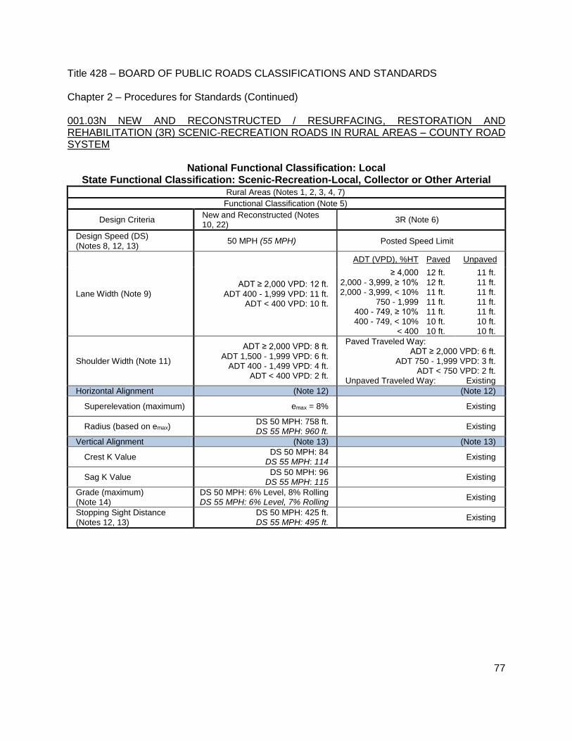
Title 428 – BOARD OF PUBLIC ROADS CLASSIFICATIONS AND STANDARDS Chapter 2 – Procedures for Standards (Continued)
77
001.03N NEW AND RECONSTRUCTED / RESURFACING, RESTORATION AND REHABILITATION (3R) SCENIC-RECREATION ROADS IN RURAL AREAS – COUNTY ROAD SYSTEM
National Functional Classification: Local State Functional Classification: Scenic-Recreation-Local, Collector or Other Arterial
Rural Areas (Notes 1, 2, 3, 4, 7) Functional Classification (Note 5)
Design Criteria New and Reconstructed (Notes 10, 22)
3R (Note 6)
Design Speed (DS)
(Notes 8, 12, 13) 50 MPH (55 MPH) Posted Speed Limit
Lane Width (Note 9) ADT ≥ 2,000 VPD: 12 ft.
ADT 400 - 1,999 VPD: 11 ft. ADT < 400 VPD: 10 ft.
ADT (VPD), %HT Paved Unpaved
≥ 4,000
2,000 - 3,999, ≥ 10% 2,000 - 3,999, < 10%
750 - 1,999 400 - 749, ≥ 10% 400 - 749, < 10%
< 400
12 ft.
12 ft. 11 ft. 11 ft. 11 ft. 10 ft. 10 ft.
11 ft.
11 ft. 11 ft. 11 ft. 11 ft. 10 ft. 10 ft.
Shoulder Width (Note 11)
ADT ≥ 2,000 VPD: 8 ft.
ADT 1,500 - 1,999 VPD: 6 ft. ADT 400 - 1,499 VPD: 4 ft.
ADT < 400 VPD: 2 ft.
Paved Traveled Way:
ADT ≥ 2,000 VPD: 6 ft. ADT 750 - 1,999 VPD: 3 ft.
ADT < 750 VPD: 2 ft. Unpaved Traveled Way: Existing
Horizontal Alignment (Note 12) (Note 12)
Superelevation (maximum) emax = 8% Existing
Radius (based on emax) DS 50 MPH: 758 ft. DS 55 MPH: 960 ft.
Existing
Vertical Alignment (Note 13) (Note 13)
Crest K Value DS 50 MPH: 84
DS 55 MPH: 114 Existing
Sag K Value DS 50 MPH: 96
DS 55 MPH: 115 Existing
Grade (maximum)
(Note 14)
DS 50 MPH: 6% Level, 8% Rolling DS 55 MPH: 6% Level, 7% Rolling
Existing
Stopping Sight Distance
(Notes 12, 13)
DS 50 MPH: 425 ft. DS 55 MPH: 495 ft.
Existing

Title 428 – BOARD OF PUBLIC ROADS CLASSIFICATIONS AND STANDARDS Chapter 2 – Procedures for Standards (Continued)
78
001.03N (Continued) NEW AND RECONSTRUCTED / RESURFACING, RESTORATION AND REHABILITATION (3R) SCENIC-RECREATION ROADS IN RURAL AREAS – COUNTY ROAD SYSTEM
National Functional Classification: Local State Functional Classification: Scenic-Recreation-Local, Collector or Other Arterial
Rural Areas (Notes 1, 2, 3, 4, 7)
Functional Classification (Note 5)
Design Criteria New and Reconstructed (Notes 10, 22) 3R (Note 6)
Cross Slope (Note 15)
Lane Paved: 1.5% to 2%
Unpaved: 2% to 6% Existing
Shoulder Paved: 2% to 6%
Aggregate: 4% to 6% Turf: 6% to 8%
Existing
Horizontal Clear Zone
(Note 16)
ADT (VPD)
Width, ft.
Existing
DS 50/55 MPH
1V:6H 1V:4H
≥ 2,000 10/14 14/18
400 - 1,999 8/10 10/14
< 400 Nominal Shoulder Width
Vertical Clearance 14.5 ft. (Note 17) Existing
Bridges
(Notes 18, 20, 21) (letters within parentheses refer to formulas in Note 18)
Clear Bridge Width ADT ≥ 2,000 VPD: 40 ft. (A)
ADT 400 - 1,999 VPD: 28 ft. (C) ADT < 400 VPD: 24 ft. (D)
ADT ≥ 4,000 VPD: 30 ft. (C)
ADT 2,000 - 3,999 VPD: 28 ft. (D) ADT 750 - 1,999 VPD: 24 ft. (F)
ADT 400 - 749 VPD: 22 ft. (H) ADT < 400 VPD: 20 ft. (H)
Structural Capacity HL93 (Note 19) (Note 19)

Title 428 – BOARD OF PUBLIC ROADS CLASSIFICATIONS AND STANDARDS Chapter 2 – Procedures for Standards (Continued)
79
001.03O NEW AND RECONSTRUCTED / RESURFACING, RESTORATION AND REHABILITATION (3R) LOW WATER STREAM CROSSINGS AND FORDS IN RURAL AREAS – COUNTY ROAD SYSTEM
National Functional Classification: Local State Functional Classification: Local or Minimum Maintenance
Rural Areas – Low Water Stream Crossings and Fords (Note 21)
Functional Classification (Note 5)
Low water stream crossings or fords may be built on county roads with ADT fewer than 50 VPD and with a State functional classification of Local or Minimum Maintenance, provided the road is not the only access to an occupied dwelling. All proposed construction, reconstruction or 3R work on a low water stream crossing or ford shall be submitted to the Board of Public Roads Classifications and Standards for review prior to the start of work or construction in accordance with the rules and regulations for relaxation of standards. New low water stream crossings or fords shall not be built on county roads with a State functional classification of Local (ADT of 50 VPD and greater), Other Arterial, Collector, Remote Residential or Scenic-Recreation. Continuation of, and maintenance of existing low water stream crossings and fords working satisfactorily will be permitted. SIGNING OF LOW WATER STREAM CROSSINGS AND FORDS Signs shall conform to the requirements in the Manual on Uniform Traffic Control Devices for Streets and Highways (MUTCD) adopted pursuant to Chapter 60, Neb. Rev. Stat. §60-6,118. Signs for low water stream crossings or fords shall be installed before the drainage way. SIGN DESIGN AND USAGE
The "Low Water Crossing Ahead" sign shall be used on Minimum Maintenance roads and Local roads in advance of all locations where low water stream crossings or fords are a part of the roadway features. The sign should be installed at a distance of 500 to 700 feet in advance of the low water stream crossing or ford.
Design Details: Size – 30 inch x 30 inch Minimum Background – Yellow reflectorized Legend – Black, 4 inch, Series D
The "Do Not Enter When Flooded" sign shall be used at all locations where low water stream crossings or fords are a part of the roadway features. The sign should be installed a distance of 15 to 25 feet in advance of the anticipated edge of the waterline on the roadway.
Design Details: Size – 24 inch x 30 inch Background – White reflectorized Legend – Black, 4 inch, Series C

Title 428 – BOARD OF PUBLIC ROADS CLASSIFICATIONS AND STANDARDS Chapter 2 – Procedures for Standards (Continued)
80
001.03O (Continued) NEW AND RECONSTRUCTED / RESURFACING, RESTORATION AND REHABILITATION (3R) LOW WATER STREAM CROSSINGS AND FORDS IN RURAL AREAS – COUNTY ROAD SYSTEM
National Functional Classification: Local State Functional Classification: Local or Minimum Maintenance
Rural Areas – Low Water Stream Crossings and Fords (Note 21)
Functional Classification (Note 5)
POSITION AND HEIGHT
Note: The lateral placement of signs is to be 6 feet minimum (where possible), otherwise a 2 feet minimum.
TYPICAL INSTALLATION CONDITIONS – LOW WATER STREAM CROSSING OR FORD
15 to 25 ft.
500 to 700 ft.
5 ft. Minimum

Title 428 – BOARD OF PUBLIC ROADS CLASSIFICATIONS AND STANDARDS Chapter 2 – Procedures for Standards (Continued)
81
001.03P NEW AND RECONSTRUCTED / RESURFACING, RESTORATION AND REHABILITATION (3R) MINIMUM MAINTENANCE ROADS IN RURAL AREAS – COUNTY ROAD SYSTEM
National Functional Classification: Local State Functional Classification: Minimum Maintenance
Rural Areas (Note 1)
Functional Classification (Note 5) RESTRICTIONS PRIOR TO CONSTRUCTION All proposed construction, reconstruction or 3R work on a segment of road functionally classified as Minimum Maintenance shall be submitted to the Board of Public Roads Classifications and Standards for review prior to the start of work or construction in accordance with the rules and regulations for relaxation of standards. However, any work (other than low water stream crossings and fords) that meets or exceeds National Local functional classification Rural Area standards does not require a relaxation of standards. NEW AND RECONSTRUCTED MINIMUM DESIGN SPEED The minimum design speed for New and Reconstructed work shall be 35 MPH. NEW AND REPLACEMENT STRUCTURES New and reconstructed bridge, non-buried structure and culvert Design Loading: HL93. NEW AND RECONSTRUCTED MINIMUM VERTICAL CLEARANCE The minimum vertical clearance at underpasses shall be 14.5 ft. (See Note 17 for further requirements and other information.) REPLACEMENT STRUCTURES (Notes 19, 21, 20) Any defective bridge or culvert or other such structure on, in, over, or under the roadway may be removed and not replaced in order to protect the public safety. Structures to be built or rebuilt will only be those that are determined by the county board to be essential for the public safety or for the present or future transportation needs of the county. Removed structures may be replaced by a ford or low water stream crossing that will permit crossing in dry weather and is intended to convey water across the roadway rather than carrying the water under the roadway. These fords shall be so constructed that they shall not constrict the passage of water across the roadway thereby causing water to back up on the adjacent properties during normally expected rainfalls. These fords may have hard surfacing placed to facilitate passage of vehicles through the waterway. The County proposal for new or replacement structures (which do not meet or exceed National Local functional classification Rural Area standards), low water stream crossings and fords shall be submitted to the Board of Public Roads Classifications and Standards for review prior to the start of work or construction in accordance with the rules and regulations for relaxation of standards. SIGNING OF MINIMUM MAINTENANCE ROADS The installation of signs shall be at the beginning and end of minimum maintenance routes and at any other public access along the route. In the event the minimum maintenance route exceeds five (5) miles in length with no intermediate public access then a minimum maintenance sign shall be installed at an interval not to exceed five (5) miles. The signs shall provide warning to the public that a lower level of maintenance exists for the designated segment of roadway than is normal for that county; they indicate a lower maintenance level and communicate if the road is a through route or has no exit where it terminates at a property line and not a connecting public road. Signs shall conform to the requirements in the Manual on Uniform Traffic Control Devices for Streets and Highways (MUTCD) adopted pursuant to Chapter 60, Neb. Rev. Stat. §60-6,118.

Title 428 – BOARD OF PUBLIC ROADS CLASSIFICATIONS AND STANDARDS Chapter 2 – Procedures for Standards (Continued)
82
001.03P (Continued) NEW AND RECONSTRUCTED / RESURFACING, RESTORATION AND REHABILITATION (3R) MINIMUM MAINTENANCE ROADS IN RURAL AREAS – COUNTY ROAD SYSTEM
National Functional Classification: Local State Functional Classification: Minimum Maintenance
Rural Areas (Note 1) Functional Classification (Note 5)
Signs that indicate bridges or culverts that are less than required by Rural Area standards for roads with a National functional classification of Local, and by fords and low water stream crossings, shall be installed before the drainage way and indicate the type of crossing or structure.
SIGN DESIGN AND USAGE
The “Minimum Maintenance Road” sign shall be used at all locations where public access to a Minimum Maintenance road occurs. The sign should be installed on the Minimum Maintenance road at a distance of 25 to 50 feet from the edge of the road providing public access.
Design Details: Size – 30 inch x 30 inch Minimum Background – Yellow reflectorized Legend – Black, 4 inch, Series C
The “Low Water Crossing Ahead” sign shall be used on Minimum Maintenance roads in advance of all locations where low water stream crossings or fords are a part of the roadway features. The sign should be installed at a distance of 500 to 700 feet in advance of the low water stream crossing or ford.
Design Details: Size – 30 inch x 30 inch Minimum Background – Yellow reflectorized Legend – Black, 4 inch, Series D
The “Do Not Enter When Flooded” sign shall be used at all locations where low water stream crossings or fords are a part of the roadway features. The sign should be installed a distance of 15 to 25 feet in advance of the anticipated edge of the waterline on the roadway.
Design Details: Size – 24 inch x 30 inch Background – White reflectorized Legend – Black, 4 inch, Series C

Title 428 – BOARD OF PUBLIC ROADS CLASSIFICATIONS AND STANDARDS Chapter 2 – Procedures for Standards (Continued)
83
001.03P (Continued) NEW AND RECONSTRUCTED / RESURFACING, RESTORATION AND REHABILITATION (3R) MINIMUM MAINTENANCE ROADS IN RURAL AREAS – COUNTY ROAD SYSTEM
National Functional Classification: Local State Functional Classification: Minimum Maintenance
Rural Areas (Note 1)
Functional Classification (Note 5)
POSITION AND HEIGHT
Note: The lateral placement of signs is to be 6 feet minimum (where possible), otherwise a 2 feet minimum.
5 ft. Minimum
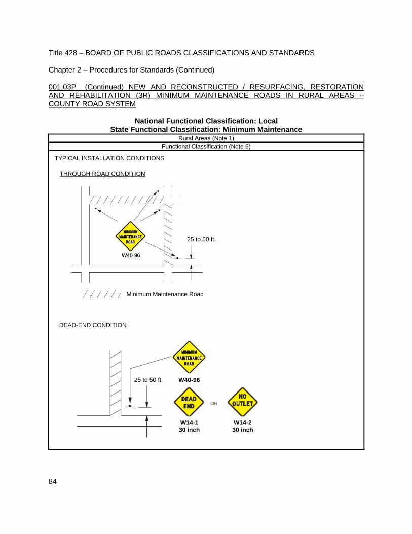
Title 428 – BOARD OF PUBLIC ROADS CLASSIFICATIONS AND STANDARDS Chapter 2 – Procedures for Standards (Continued)
84
001.03P (Continued) NEW AND RECONSTRUCTED / RESURFACING, RESTORATION AND REHABILITATION (3R) MINIMUM MAINTENANCE ROADS IN RURAL AREAS – COUNTY ROAD SYSTEM
National Functional Classification: Local State Functional Classification: Minimum Maintenance
Rural Areas (Note 1)
Functional Classification (Note 5)
TYPICAL INSTALLATION CONDITIONS
25 to 50 ft.
Minimum Maintenance Road
THROUGH ROAD CONDITION
DEAD-END CONDITION
25 to 50 ft.
W14-1 30 inch
W14-2 30 inch
W40-96

Title 428 – BOARD OF PUBLIC ROADS CLASSIFICATIONS AND STANDARDS Chapter 2 – Procedures for Standards (Continued)
85
001.03P (Continued) NEW AND RECONSTRUCTED / RESURFACING, RESTORATION AND REHABILITATION (3R) MINIMUM MAINTENANCE ROADS IN RURAL AREAS – COUNTY ROAD SYSTEM
National Functional Classification: Local State Functional Classification: Minimum Maintenance
Rural Areas (Note 1)
Functional Classification (Note 5)
LOW WATER STREAM CROSSING OR FORD
PARTIAL ROAD CONDITION
25 to 50 ft.
25 to 50 ft.
15 to 25 ft. 500 to 700 ft.
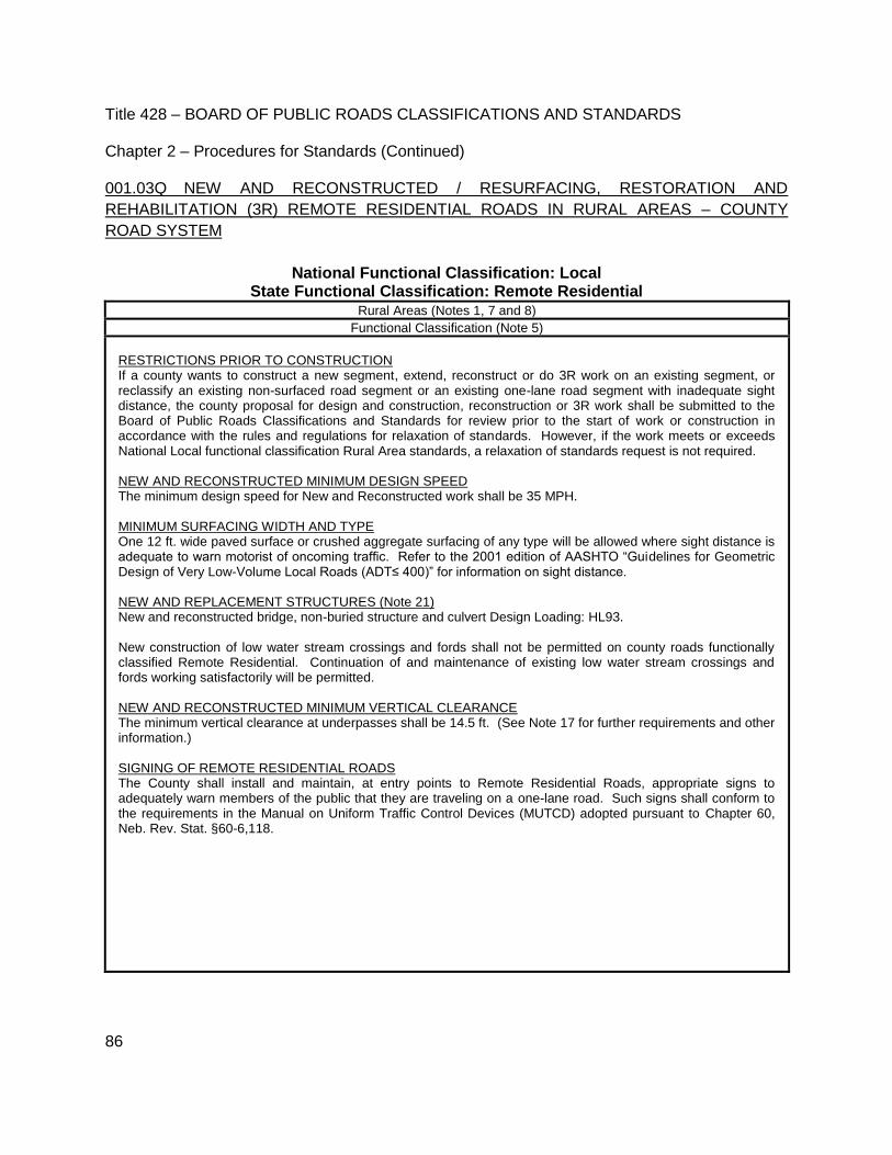
Title 428 – BOARD OF PUBLIC ROADS CLASSIFICATIONS AND STANDARDS Chapter 2 – Procedures for Standards (Continued)
86
001.03Q NEW AND RECONSTRUCTED / RESURFACING, RESTORATION AND
REHABILITATION (3R) REMOTE RESIDENTIAL ROADS IN RURAL AREAS – COUNTY
ROAD SYSTEM
National Functional Classification: Local State Functional Classification: Remote Residential
Rural Areas (Notes 1, 7 and 8)
Functional Classification (Note 5)
RESTRICTIONS PRIOR TO CONSTRUCTION If a county wants to construct a new segment, extend, reconstruct or do 3R work on an existing segment, or reclassify an existing non-surfaced road segment or an existing one-lane road segment with inadequate sight distance, the county proposal for design and construction, reconstruction or 3R work shall be submitted to the Board of Public Roads Classifications and Standards for review prior to the start of work or construction in accordance with the rules and regulations for relaxation of standards. However, if the work meets or exceeds National Local functional classification Rural Area standards, a relaxation of standards request is not required. NEW AND RECONSTRUCTED MINIMUM DESIGN SPEED The minimum design speed for New and Reconstructed work shall be 35 MPH. MINIMUM SURFACING WIDTH AND TYPE One 12 ft. wide paved surface or crushed aggregate surfacing of any type will be allowed where sight distance is adequate to warn motorist of oncoming traffic. Refer to the 2001 edition of AASHTO “Guidelines for Geometric Design of Very Low-Volume Local Roads (ADT≤ 400)” for information on sight distance. NEW AND REPLACEMENT STRUCTURES (Note 21) New and reconstructed bridge, non-buried structure and culvert Design Loading: HL93. New construction of low water stream crossings and fords shall not be permitted on county roads functionally classified Remote Residential. Continuation of and maintenance of existing low water stream crossings and fords working satisfactorily will be permitted. NEW AND RECONSTRUCTED MINIMUM VERTICAL CLEARANCE The minimum vertical clearance at underpasses shall be 14.5 ft. (See Note 17 for further requirements and other information.) SIGNING OF REMOTE RESIDENTIAL ROADS The County shall install and maintain, at entry points to Remote Residential Roads, appropriate signs to adequately warn members of the public that they are traveling on a one-lane road. Such signs shall conform to the requirements in the Manual on Uniform Traffic Control Devices (MUTCD) adopted pursuant to Chapter 60, Neb. Rev. Stat. §60-6,118.
Title 428 – BOARD OF PUBLIC ROADS CLASSIFICATIONS AND STANDARDS Chapter 2 – Procedures for Standards (Continued)
87
002 MINIMUM CONSTRUCTION STANDARDS – STATE HIGHWAY, COUNTY ROAD, AND MUNICIPAL STREET SYSTEMS
002.01 RURAL HIGHWAYS – NEB. REV. STAT. §39-2103
002.01A STATE FUNCTIONAL CLASSIFICATIONS – INTERSTATE, EXPRESSWAY, MAJOR ARTERIAL, OTHER ARTERIAL, COLLECTOR, SCENIC-RECREATION- MAJOR ARTERIAL, SCENIC-RECREATION-OTHER ARTERIAL AND SCENIC-RECREATION-COLLECTOR – shall require all construction to be in accordance with the NDOR, Nebraska Department of Roads, 2007 Standard Specifications for Highway Construction. 002.01B STATE FUNCTIONAL CLASSIFICATIONS – LOCAL, REMOTE RESIDENTIAL, MINIMUM MAINTENANCE AND SCENIC-RECREATION-LOCAL – shall require that all construction follow the NDOR, Nebraska Department of Roads, 2007 Standard Specifications for Highway Construction, as a guide to good construction methods.
002.02 MUNICIPAL STREETS - NEB. REV. STAT. §39-2104
002.02A STATE FUNCTIONAL CLASSIFICATIONS – INTERSTATE, EXPRESSWAY, MAJOR ARTERIAL, OTHER ARTERIAL, AND COLLECTOR – shall require all construction to be in accordance with the NDOR, Nebraska Department of Roads, 2007 Standard Specifications for Highway Construction.
002.02B STATE FUNCTIONAL CLASSIFICATION – LOCAL – shall require that all construction follow the NDOR, Nebraska Department of Roads, 2007 Standard Specifications for Highway Construction, as a guide to good construction methods.
002.03 EXCEPTION – With the exception of highways, roads and streets on the National Highway System, any county or municipality may be permitted to use their own construction specifications if such specifications are equivalent in quality to the NDOR, Nebraska Department of Roads, 2007 Standard Specifications for Highway Construction. 002.04 APPLICATION – Minimum Construction Standards apply to new construction, reconstruction and 3R work. 002.05 QUALITY AND PLACEMENT OF MATERIALS – COUNTY ROADS AND MUNICIPAL STREETS – For roads and streets under the jurisdictional responsibility of counties and municipalities the County Highway Superintendent, in the case of counties, or the City Street Superintendent, in the case of municipalities, shall have the responsibility to see that acceptable materials are furnished and properly placed. In counties and municipalities lacking such officer, that responsibility applies to the person responsible for the county highway or municipal street program, respectively. In the case of multiple entities, each entity has the responsibility to see that acceptable materials are furnished and properly placed.

Title 428 – BOARD OF PUBLIC ROADS CLASSIFICATIONS AND STANDARDS Chapter 2 – Procedures for Standards (Continued)
88
003 MINIMUM MAINTENANCE STANDARDS – STATE HIGHWAY, COUNTY ROAD, AND MUNICIPAL STREET SYSTEMS – Applicable to each functional classification set forth in Chapter 39, Article 21 Neb. Rev. Stat.
003.01 STATE FUNCTIONAL CLASSIFICATIONS – INTERSTATE, EXPRESSWAY, MAJOR ARTERIAL, COLLECTOR, LOCAL, SCENIC-RECREATION-MAJOR ARTERIAL, SCENIC-RECREATION-OTHER ARTERIAL, SCENIC-RECREATION-COLLECTOR AND SCENIC-RECREATION-LOCAL
003.01A DEFINITION Maintenance is defined as the preservation and upkeep of a highway, road or street including all its elements, in a condition as near as is practical to the original or as constructed condition in order to provide the road user with a safe and convenient highway facility. 003.01B LIMITS OF MAINTENANCE Routine Maintenance funds should be used only for the restoration and repair of the roadway and roadside to the safe and usable condition to which it was constructed and for limited roadside maintenance such as mowing the shoulders of the road, filling shoulder washes, cleaning ditches and backfilling small slides or washouts. 003.01C PHYSICAL MAINTENANCE The following routine maintenance operations, replacements, and minor additions, although not all inclusive, are considered to be physical maintenance.
003.01C1 ROADWAY SURFACES
Scarifying, reshaping, and restoring material losses.
Applying dust palliatives.
Patching, repairing, surface treating, joint filling, and mudjacking on bituminous or concrete surfaces.
Resurfacing of concrete, brick, or bituminous pavements.
Replacement of traveled way and shoulder in-kind.
Replacement of unsuitable base materials in patching operations.
Title 428 – BOARD OF PUBLIC ROADS CLASSIFICATIONS AND STANDARDS Chapter 2 – Procedures for Standards (Continued)
89
003.01C2 SHOULDERS AND SIDE ROAD APPROACHES
Scarifying, reshaping and restoring material losses.
Applying dust palliatives.
Patching and repairing all surface types, including base.
Resealing bituminous types.
Reseeding and resodding.
003.01C3 ROADSIDE AND DRAINAGE
Reshaping of drainage channels and sideslopes.
Restoration of erosion controls.
Cleaning and repairing culverts.
Removing slides.
Mowing and tree trimming.
Replacing topsoil, sod, shrubs, etc.
Replacement, with essentially the same design, of curb, gutter, riprap, and underdrain.
003.01C4 STRUCTURES
Cleaning, painting, and repairing.
Replacements, with essentially the same design, of rails, floors, stringers, piling and beams. Steel piling may be used to replace timber piling.
Replacement of walls in-kind.
003.01C5 The replacements and additions of a minor nature as listed above are considered to be physical maintenance. Where they become extensive or costly, such operations should not be charged to maintenance but to construction.
Title 428 – BOARD OF PUBLIC ROADS CLASSIFICATIONS AND STANDARDS Chapter 2 – Procedures for Standards (Continued)
90
003.02 STATE FUNCTIONAL CLASSIFICATION – MINIMUM MAINTENANCE
003.02A DEFINITION Maintenance for Minimum Maintenance roads shall be defined as providing only those activities and services required for the usage by farm machinery and occasional or intermittent use by passenger or commercial vehicles. 003.02B LIMITS OF MAINTENANCE Funds can be used to provide for repair and restoration of culverts and bridges only if required for safe passage of the occasional usage. Snow plowing, placement of any surfacing material, including gravel or crushed aggregate of any type and mowing of the roadway is not required for this classification of road; however, roadway and roadside mowing may be necessary in order to provide for safety at intersections and to permit passing.
003.03 STATE FUNCTIONAL CLASSIFICATION – REMOTE RESIDENTIAL
003.03A DEFINITION Maintenance for Remote Residential roads shall be defined to require only those activities and services necessary to provide access to remote residences, farms and ranches by passenger and commercial vehicles. 003.03B LIMITS OF MAINTENANCE Routine Maintenance funds should only be used for the restoration and repair of the roadway and roadside to the safe and usable condition to which it was constructed and for limited roadside maintenance such as mowing the shoulders of the road, filling shoulder washes, cleaning ditches and backfilling small slides or washouts. On existing aggregate surfaced or paved surfaced roads reclassified to Remote Residential, maintenance includes maintaining the roadway and roadside and the surfacing width that existed at the time the road was reclassified or converting all or part of the existing pavement to crushed aggregate of any type, provided the existing traveled way width and surfacing width is maintained.
003.04 ALL STATE FUNCTIONAL CLASSIFICATIONS
003.04A TRAFFIC SERVICES The following maintenance operations, although not all inclusive, are considered to be traffic services to the public.
003.04A1 SNOW All operations resulting from snow, such as erection of snow fences to minimize snowdrifts and the actual removal of snow from the roadway.
Title 428 – BOARD OF PUBLIC ROADS CLASSIFICATIONS AND STANDARDS Chapter 2 – Procedures for Standards (Continued)
91
003.04A2 ICE All operations to reduce hazard due to icing of the roadway surface; such as, sanding, the application of chemicals to lower melting point, opening of inlets, actual removal of ice as by scraping, and in some instances the supplying of heat.
003.04A3 TRAFFIC CONTROL AND SERVICE FACILITIES
Replacement of guardrail in-kind.
Painting, repairing, and replacement or additions of traffic control devices, and lighting standards.
The furnishing of power for lighting and traffic control devices and the regular replacement of parts such as light bulbs.
Maintaining rest areas.
Replacement of roadside rest areas in-kind.
003.04A4 ROAD SERVICES The cost of services performed directly for road users, among which are supervision of roadside rest areas, cleaning operations on roadsides, motor vehicle repair and towing services, and operation of information booths.
003.05 UNUSUAL OR DISASTER OPERATIONS Extensive repair or replacement due to damage as a result of storm, flood, or military operations may be considered as extraordinary maintenance, betterment, 3R work, reconstruction, or even as new construction. Each case should be considered separately and usually it is advantageous to keep all such accounts together under the heading of Unusual or Disaster Operations.

Title 428 – BOARD OF PUBLIC ROADS CLASSIFICATIONS AND STANDARDS Chapter 2 – Procedures for Standards (Continued)
92
004 RELAXATION OF STANDARDS – STATE HIGHWAY, COUNTY ROAD, AND MUNICIPAL STREET SYSTEMS
004.01 Whenever the application of standards of design, construction, or maintenance, as promulgated by the Board of Public Roads Classifications and Standards, works a special hardship on any segment of highway, road, or street, a county or municipality may request that the Board relax the standards for such segment.
004.01A All requests for relaxation of standards must be in writing and must be filed with the Secretary for the Board. All requests for relaxation of standards for federally funded projects are required to be reviewed by NDOR prior to filing with the Secretary for the Board. All county requests for relaxation of standards must be made by the County Highway Superintendent for that county, or in counties lacking such officer, by the person responsible for the county highway program. All municipal requests for relaxation of standards must be made by the City Street Superintendent for that municipality, or in municipalities lacking such officer, by the person responsible for the municipal street program. In the case of multiple entities, each entity must sign and file a resolution of adoption, and there must be a written request from each entity’s superintendent (or in entities lacking such officer, the person responsible for the highway, road or street program). Additionally, whenever the application of standards of design, construction, or maintenance would defeat the purpose of the Scenic-Recreation functional classification, a county, municipality or other interested party may request that the Board relax the standards for such segment. There must be compelling and demonstrated reasons why standard values should not be used. All requests shall specify in detail what peculiar, special or unique situations would make the application of the standards not feasible. Analysis should include consideration of adjacent roadway sections therefore the relaxation of standards request may need to include sub-standard conditions beyond construction limits. Documentation for county road and municipal street relaxation of standards shall describe and explain the conditions that preclude conformance to the applicable design standard, including but not limited to the following:
004.01A1 One (1) copy of the Resolution of Adoption signed by the proper officials. 004.01A2 One (1) copy of a completed NBCS Form 7 One- and Six-Year Plan Highway or Street Improvement Project, from the current One- and Six-Year Plan, or NBCS Form 10 Notification of Revision of One-Year Plan, if the work is being added to the One-Year Plan.
Title 428 – BOARD OF PUBLIC ROADS CLASSIFICATIONS AND STANDARDS Chapter 2 – Procedures for Standards (Continued)
93
004.01A3 Project identifiers on documentation, including federal-aid project numbers and control numbers for federally funded projects, and structure numbers. 004.01A4 For federal-aid projects, documentation of approval by NDOR. 004.01A5 One (1) copy of proposed construction plan sheets which are pertinent to the request. 004.01A6 A map, aerial photograph or topographic map showing the location and area of the work. 004.01A7 Identification of the applicable standards (Rural Area, Urban Area, etc.), State and National functional classifications, and type of work (New, Reconstructed and/or 3R). 004.01A8 Applicable State and National functional classification maps. 004.01A9 Design data (current and design traffic volumes, design speed, posted speed, percent of heavy trucks, hydraulic study if applicable, geometrics, and other such pertinent information). 004.01A10 The required standard value and the proposed value of the design feature shall be clearly stated. 004.01A11 Effect on the safety and operation of the facility, and its compatibility with adjacent sections of the road or street. The overall safety of the road or street should not be degraded. 004.01A12 Sufficient crash history analysis should include the crash rate and/or history of the project to comparable routes, identifying crash types and crash trends within the project limits, and locations for potential safety improvements. 004.01A13 A detailed cost analysis of attaining full standards versus the requested alternative or alternatives must be quantified. 004.01A14 Features (improved roadway geometry, signing, delineation, roadside safety, etc.) added to mitigate the effects of not meeting minimum design standards. 004.01A15 Future improvements or work that will correct the substandard design feature, including project number (if available) and anticipated or estimated construction dates. 004.01A16 Environmental impacts including scenic, historic and other environmental features, if full standards cannot be achieved due to environmental implications.

Title 428 – BOARD OF PUBLIC ROADS CLASSIFICATIONS AND STANDARDS Chapter 2 – Procedures for Standards (Continued)
94
004.01A17 Other factors that could affect the decision: for example, proposed development in the project area or local concerns may be issues to be addressed. 004.01A18 Attachments shall include the existing typical section and the proposed typical section.
004.01B A request for relaxation of standards for a Scenic-Recreation highway, road or street by any county or other interested party shall also include:
004.01B1 One (1) copy stating what application of such standard would defeat the purpose of the Scenic-Recreation functional classification. 004.01B2 One (1) copy of a certification of approval or disapproval of the request by the governing body having jurisdictional responsibility for that segment of highway, road or street.
004.01C A request for relaxation of standards for a low water stream crossing or ford shall also include:
004.01C1 A statement that the road does not provide the only access to an occupied dwelling. Low water stream crossings or fords will normally not be permitted in any road providing primary access to an occupied dwelling.
004.01D Upon receipt of a request, the Secretary for the Board shall set a hearing date for the request no later than sixty (60) days after the filing of the request, and notice will be given to the requesting party at least ten (10) days prior to the hearing.
004.01E Upon the date of the hearing, the board will meet and consider the request. After considering all information before the board, the board shall:
004.01E1 Vote to grant or deny, in whole or in part, the relaxation request, or; 004.01E2 Vote to continue the hearing until the next meeting. A request may only be continued once before the board must act as stated in 004.01E1.
004.01F An affirmative vote of at least six (6) members will be necessary to grant, deny or continue a request. A permanent record will be maintained of the board’s decision. A copy will be distributed to the party requesting the relaxation, to the Nebraska Department of Roads, and to any interested party requesting a record of the proceeding. 004.01G If the board votes to continue a request, the board should make a record in its minutes of the reason for the continuance and whether, and if so, what additional information is needed. The board shall notify the party requesting the relaxation of what information is needed and the requesting party shall provide such within fourteen (14) days of the board’s action.

2016 Minimum Standards (428 NAC 2) Board of Public Roads Classifications and Standards (NBCS)
Guidelines for
Relaxation of Standards Requests for Developed Designs Adopted by NBCS on May 20, 2016
94a
1. Given that
a. The NBCS adopted a major update of regulation 428 NAC 2 for county roads and municipal
streets, and
b. The updated 428 NAC 2 became effective on May 17, 2016, and
c. Revising a developed design (work or a project in an advanced stage of pre-construction
development) to meet minimum design standards (MDS) now required by 428 NAC 2 may delay
construction or increase the cost, thus creating a special hardship, and
d. A developed design (work or project), in the context of this guidance, is defined as:
i. Work in final design development, including
A. final plans completed as of May 17, 2016 but not yet advertised for construction bids, or
has not started the construction bid solicitation process, or
B. plans are in NDOR PS&E for final review (Federal/State funds), or are being advertised
for bids status (Local level), as of May 17, 2016, or
C. a valid NEPA document as of May 17, 2016 for a Federal-aid project accompanied with
prepared plans.
2. The NBCS provides the following guidance:
a. A relaxation of standards is not required for work or a project which meets the 2010 MDS (or
has previously been granted a relaxation of standards) if, on May 17, 2016 the work or project:
i. Was already awarded to contract or under construction, or
ii. Was being advertised for letting, or was in the construction solicitation process, or any
subsequent step in those processes as long as it is awarded to contract by November 17,
2016.
b. A developed design which does not meet 428 NAC 2 requires a relaxation of standards request
submitted by February 1, 2017 in order to receive special consideration; see the caveat below.
After that date, a developed design will not receive special consideration and will be treated as
any other request for a relaxation of standards.
i. A developed design for which NBCS granted a relaxation of standards on or prior to May 20,
2016 does not require another relaxation of standards request from NBCS again for the
same issue(s), assuming that circumstances upon which the relaxation of standards was
based are essentially the same.
c. Irrespective of any of the above, if a relaxation of standards has been granted for HL93
structural capacity prior to adoption of these guidelines, the relaxation stands indefinitely and
need not be brought to the NBCS again.

Relaxation of Standards Request Transition to New Standards - Special Request for a Developed Design
Date of Request: [must be before February 1, 2017] All requirements of 428 NAC 2.004 must be met; this form fulfills only some requirements
Project No. __________________________ Federal Project No./Control No. ______________________
Structure No. ________________________ Project Length: _______ mi Location Map is attached
National Functional Classification (map is attached):
Other Principal Arterial Minor Arterial Major Collector Minor Collector Local
State Functional Classification (map is attached): Major Arterial Other Arterial Collector Local
Scenic-Recreation Minimum Maintenance Remote Residential
Standards: Urban Area Rural Area ADT = ______ VPD, ADT Year = 20___, Heavy Trucks = ___%
Type of Work (per new standards ): New and Reconstructed 3R
Design Speed = _____ MPH Anticipated (Post-Project) Posted Speed Limit = _____ MPH
Surface: Paved Unpaved Section: Curbed Non-curbed Terrain: Level Rolling
94b
1. New minimum design standards became effective on May 17, 2016. 2. The subject work/project is a developed design defined by NBCS guidance of May 20, 2016. It is in
final plans development, with the following status: [examples: approved NEPA document date; in PS&E; will be advertising for bids on date, will start the solicitation process on date, etc.], i. a registered Professional Engineer has stamped the plans and signed, if required, on or before
May 17, 2016, ii. meets the 2010 minimum design standards or has been granted appropriate relaxation of
standards for [which standard(s) was (were) relaxed] on [date granted by NBCS], and iii. does not meet 2016 minimum design standards for the following design criterion (criteria):
Design Speed
Lane Width
Shoulder Width
Curve Radius
Superelevation
Vertical Curve
Grade
Stopping Sight Distance
Cross Slope
Horizontal Clear Zone
Vertical Clearance
Clear Bridge Width
Structural Capacity
3. Updating the design of this work/project to meet the new standards will cause a special hardship. See supporting information and justification in the space below (add sheets as necessary) describing the impacts, including delays and additional costs, the proposed value(s) which does (do) not meet the 2016 standard and any mitigation or justification in support of moving forward without re-designing the work or project.
Some work that may have been considered as Maintenance under the 2010 standards may now, under the 2016 standards, be considered New & Reconstructed (e.g. in-kind culvert replacement) or 3R (e.g. a 3-inch overlay).

Title 428 – BOARD OF PUBLIC ROADS CLASSIFICATIONS AND STANDARDS Chapter 2 – Procedures for Standards (Continued)
95
005 STANDARD COMPLIANCE INSPECTION PROCEDURES – STATE HIGHWAY,
COUNTY ROAD, AND MUNICIPAL STREET SYSTEMS
005.01 The Board of Public Roads Classifications and Standards may make random checks of construction projects in accordance with Neb. Rev. Stat. §39-2122 to determine that the minimum standards of design and construction are being met for any public highway, road or street. Inspection priorities are:
005.01A In response to a complaint received by the Board. 005.01B In response to a written request for inspection by a County Highway or a City Street Superintendent. Such request will include a certification of approval of the request by the County Board of the requesting county or the City Council or Village Board of the requesting municipality. 005.01C Projects selected for inspection by random methods.
005.02 The Board shall request necessary professional services from the Nebraska Department of Roads for the Standard Compliance Inspection Program. 005.03 The Board shall schedule inspections not less than sixty (60) days in advance. The Secretary for the Board will notify the County Board or the City Council or Village Board at least twenty (20) days prior to the scheduled inspection. The notification letter will contain:
005.03A Project identification(s) of all projects within their jurisdiction to be inspected. 005.03B Invitation to the County Board or the City Council or Village Board members and the County Highway Superintendent or City Street Superintendent to accompany the inspection party of the Board. 005.03C Name(s) of Board Representative(s). 005.03D A request that the County Board or the City Council or Village Board furnish the name(s) of their inspection team representative(s) if any, to the Board at least five (5) days prior to the scheduled inspection.

Title 428 – BOARD OF PUBLIC ROADS CLASSIFICATIONS AND STANDARDS Chapter 2 – Procedures for Standards (Continued)
96
005.04 A written standard compliance inspection report shall be prepared by the Nebraska Department of Roads within three (3) working days following the inspection using a form prescribed by the Board. The inspection report shall contain:
005.04A A map showing the project identification and location. 005.04B The name and mailing address of each member of the inspection party. 005.04C Scope of the inspection. 005.04D A summary of findings and recommendations.
005.05 The Board shall review standards compliance inspection reports within sixty (60) days. Upon acceptance of the report by the Board, the governing authority having project jurisdiction shall be notified of the summary of findings and recommendations if any.