Embed Size (px)
Citation preview
IJ\ND APPLICATION OF BIOSOLIDS SAM BAZZANELLA
LO03(HELDS15 17,20.21) LOUISA COUNTY, VIRGINIA
JULY 2011
a
C*WM*L
Norniwu "'i
MAY 15 2814
MazmiomcE
#*wo*
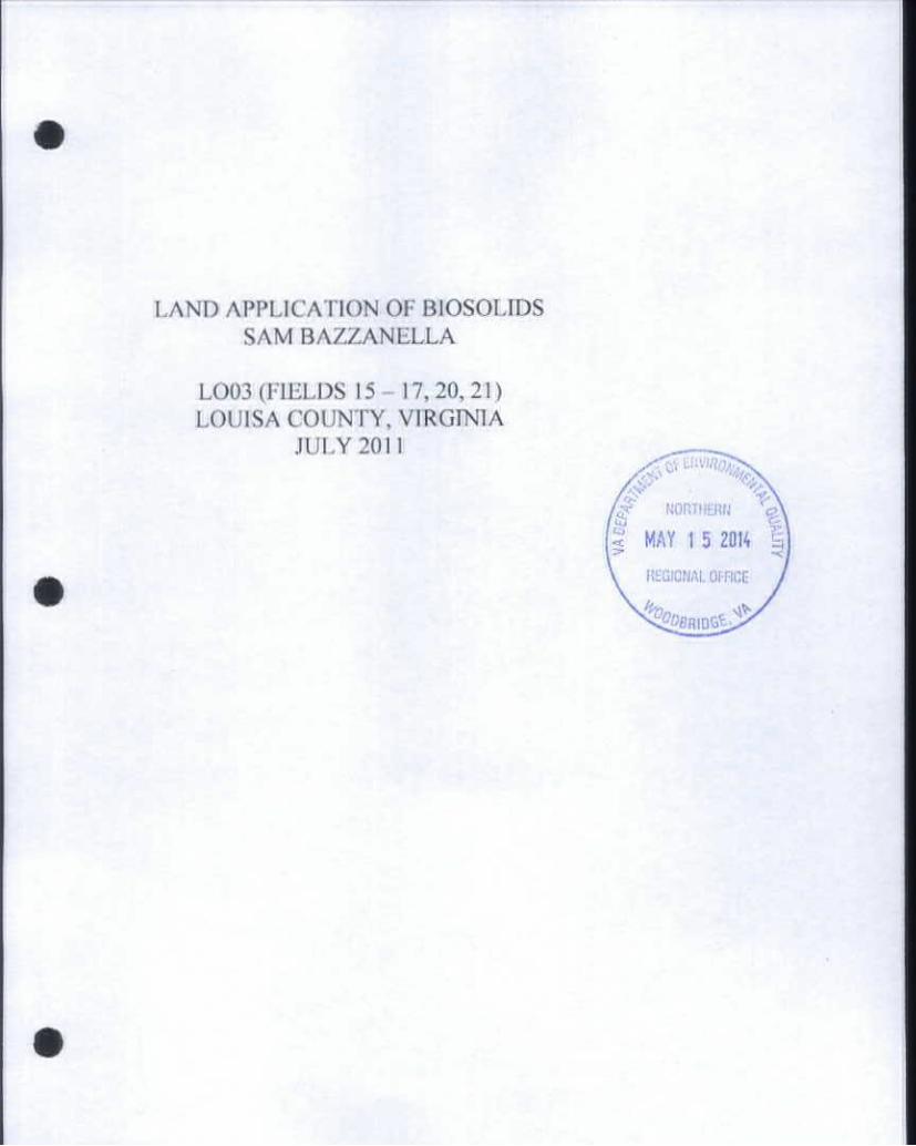
M*yll,20l2
Mr. Edwmd Shwt Dcpanmenl of Environmental Quality Northern Virginia Regional Office 1)901 CwwnCdwt Woodbht%e,VA 22193
D«»rMr. Stornl:
Transmitted herein tor your consideration is land application site for Sam Baz/anella (designated as LO 03, fields 15-17, 20, 21) located in Louisa County, Virginia. This submission contains strictly site-specific information. Please refer lo the operations and maintenance manual submitted under separate cover tor all non-site specific information.
Do not hesitate lo contact me at (804) 433-2170 should you have any questions or require additional information.
Kdly M. Low* k j Technical Services Director
KML/cmw
M*47 71Am«WrTWlOwvMm. # m*m»|*M) #Q TITO* F*c(*04)ZO-m4

SYNAGRG FIELD SUMMARY SHEET
Sam Bazzanella LO03
SYNAGRO GROSS NET PSA FSA T()PO
FIELD ACRES ACRES TRACT FIELD QUAD OWNER
# 1 #
03-15 48.6 4&6 1510 34,11. Mineral Manslield Limited Liability Co 03-16 47.4 46,4 1510 1.4.7^.25 Mineral Mansfield Limited Liability Co 03-17 7.4 * j 1510 14 Mineral Mansfield Limited Liability Co 03-20 44J 41$ on 1,3.4.6 Mineral Millstone 1 arm Limited Liability Co 03-21 aw 2&# 2 Mineral Millstone Farm Limited Liability Co
TOTALS: 172.3
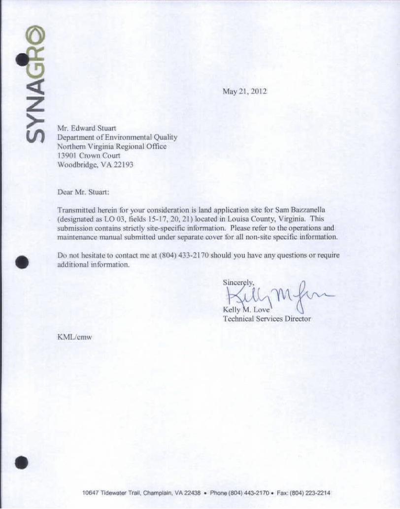
Appendix I 5 4 * 1 Lb 3 *j Lo , 9
VIRGINIA POLLUTION ABATEMENT APPLICATION FORM D: MUNICIPAL EFFLUENT AND BIOSOLIDS
PARTDWI: L A N D A P P U C * T K ) N A Q R a * B f T - B K a ( ^
A This biosolids/industrial residuals land application agreement is made on N w ^ h ^ l i - 4 J W ^ T P v ^ A ^ M W W k iW*nMlk ih«mmTmidmmer.mnd
i h d i z between J h W i M ^ ' U4J
referred to here as the "Permittee " This agreement remains In effect until it is terminated iff writing by either party or until ownership of all parcels changes. If ownership of individual parcels identified in this agreement changes, those parcels for which ownership has changed will no longer be authorized to receive biosolids or industrial residuals under this agreement
Lo ^6 Landowner: I am the registered owner of real property known as Virginia, which includes the agricultural sites Identified below in Table 1 and Identified on the tax map(s) attached wEddcm A.
bcmWdm I
Table 1A Parcels authorized to receive biosolids. water treatment residuals or other industrial sludges
Tax Parcel ID
Ik-15 T@*Pmo##C Tax Parcel ID Tax Parcel ID
lb-1
j AOdilkmal parcels containing Land Appitcatton Sites are Identified on Supplement A (check H applicable)
Check one Q^Tam the sole owner of the properties identified herein. • I am one of multiple owners of the properties identified herein.
In the event that I. the landowner, sell or transfer all or part of the property to which biosolids have been applied within 38 months ot the latest date oF biosolids application. I shall:
1. Notify the purchaser of the applicable public access and crop management restrictions no later than the closing date; and
2 Notify the permit holder of the sale within two weeks following closing.
I have no other agreements for land application on the fields identified herein I will notify the permittee immediately foomabmchmno««uohOw#wmWtMmmno agreement becomes invalid
I hereby grant permission to the Permittee to land apply residuals as specified below, on the agricultural sites Kbn#WWxw*«ndlnENMb#A. l«Wgn*Mp#nn l *$ lon#orDEQ#W*ooon^^
b m * % during or mAwhrn^ Class B biosolids Water treatment residuals Food processing waste Other industrial sludges ZfYes - D N o ZTYes • No DTres • No Q-Yes • No
, & landowner - Printed Name %i m ' : Mailmg Address
n * W # :
aAATO , Ihe permittee, agrees to apply biosolids and/or industrial residuals on the landowner's lanotn the "manner authorized by the VPA Permit Regulation and in amounts not to exceed the rates identified In the nutrient management plan prepared for each land application field by a person certified in accordance with §10.1-1.04.2 of the Code of Virginia. Permittee will provide a copy of the NMP to the landowner within 30 days after land application has commenced. If the plan requires modification to reflect the actual application rates or farming practices at the site, a revised plan will be provided within 2 weeks of the modification.
Permittee agrees to notify landowner or landowner designee of the proposed schedule for land application and specifically prior to any particular application to landowner's land. Notice shall include the source of residuals to be applied.
hWu&n HokiNwar Permittee - Authorized Representative
Pnnted Name
Rnv inttMMM I
Signature A*'*? //i/L/
Mailing Address
W a — " i
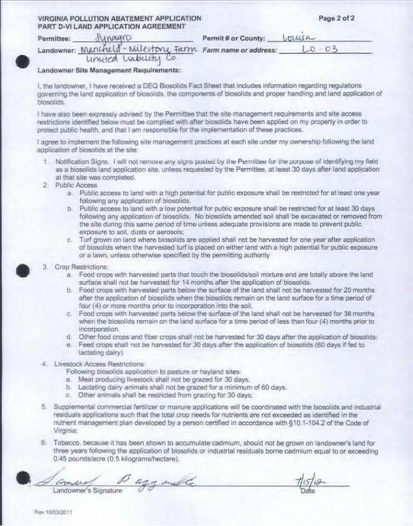
VIRGINIA POLLUTION ABATEMENT APPLICATION Page 2 of 2 PART D-VI LAND APPLICATION AGREEMENT
Permittee: i "U|U*4fD Permit tt or County: I c i U i A_
Landowner: W X W l w U T " W i i f s f P f U fa-fm Farm name or address: U P C &
UnuMd LuUxWu w Landowner Site Management Requirements:
I. the landowner. I have received a DEQ Biosolids Fact Sheet that induces information regarding regulations governing the land application of biosolids. Ihe components of biosolids and proper handling and land application of biosolids.
I have also been expressly advised by the Permittee that the site management requirements and site access restrictions identified below must be complied with after biosolids have been applied on my property in order to protect public health, and that I am responsible for the Implementation of these practices.
I agree to implement the following site management practices at each site under my ownership following the land application of biosolids at the site
1. Notification Signs. I will nol remove any blyns ousted by II ie Permittee fot Ihe purpose of identifying my field as a biosolids land application site, unless requested by the Permittee, at least 30 days after land application at that site was completed.
i mamcAccM* a. Public access to land with a high potential for public exposure shall be restricted for at least one year
following any application of biosolids. b. Public access to land with a low potential for public exposure shall be restricted for at least 30 days
following any application of biosolids. No biosolids amended soil shall be excavated or removed from the site during this same period of time unless adequate provisions are made to prevent public exposure to soil, dusts or aorosols;
c Turf grown on land where biosolids are applied shall not be harvested for one year after application of biosolids when the harvested turf is placed on either land with a high potential for public exposure or a lawn, unless otherwise specified by the permitting authority
3 Crop Restrictions: a Food crops with harvested parts thai touch the biosolids/soil mixture and are totally above the land
surface shall not be harvested for 14 months after the application of biosolids. b. Food crops with harvested parts below the surface of the land shall not be harvested for 20 months
after the application of biosolids when the biosolids remain on the land surface for a time penod of four (4) or more months prior to Incorporation into the soil,
c. Food crops with harvested parts below the surface of the land shall not be harvested for 38 months when the biosolids remain on the land surface for a time period of less than four (4) months prior to incorporation
d. Other food crops and fiber crops shall not be harvested for 30 days after the application of biosolids, e. Feed crops shall not be harvested for 30 days after the application of biosolids (60 days rf fed to
lactating dairy)
4. Livestock Access Restrictions. Following biosolids application to pasture or hayfand sites a Meat producing livestock shall not be grazed for 30 days, b Lactating dairy animals shell not be grazed for a minimum of 60 days. c. Other animals shall be restricted from grazing for 30 days;
5. Supplemental commercial fertilizer or manure applications will be coordinated with the biosolids and industrial residuals applications such that the total crop needs for nutrients are not exceeded as identified in the nutrient management plan developed by a person certified in accordance with §10 1-104.2 of the Code of Virginia;
6 Tobacco, because It has been shown to accumulate cadmium, should not be grown on landowner's land for three years following the application of biosolids or industrial residuals borne cadmium equal to or exceeding 0.45 pounds/acre (0.5 kilograms/hectare).
. i ' i l i iWMt ' f •• S i ! | n ; » l u n • f % r ^ f m*##**mn
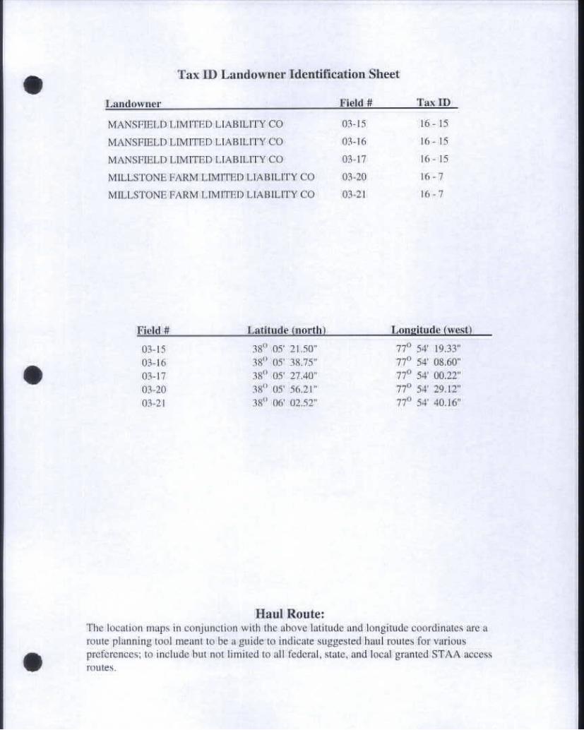
Tax ID Landowner Identification Sheet
Landowner Field # Tax ID
MANSFIELD LIMITED LIABILITY CO 03-15 16 - 15
MANSFIELD LIMITED LIABILITY CO 03-16 16 - 15
MAN9PCLDLMTnmUABILrnrCO 03-17 16-15
MILLaTONEFAmMUMmmUABOJTYCO 0W0 16-7
MIUjmNEFARMIJMITmLLKBUJTYCO K-2I 16-7
Field ff Latitude (north) Longitude (west)
00-13 3 f W 21 JO" 77"Sf:A33" 03-16 30° OT 30.73" 77° 3f 0K60" 03-17 30° OT 2740" 77* 3f 002T 03-ao 3#* or a u r 7 f 3f 2#.o" 03-21 3 f Of 02JT 77* 3f 40.W
Haul Route: The location maps in conjunction with the above latitude and longitude coordinates arc a route planning tool meant to be a guide to indicate suggested haul routes for various preferences; to include but not limited to all federal, state, and local granted ST A A access routes.

Scmk 1:1*055.954*22 D*W: 05/21/2012 WnW By: ComWnnm %M#mmlUm
•pa County assumes no liability for any errors, omissions, or Inaccuracies In the Information provided regardless of cause of such or for any decision made, action taken, or action not taken by the user In reliance upon any maps or
data provided herein. Please consult official County plats and records for official Information.
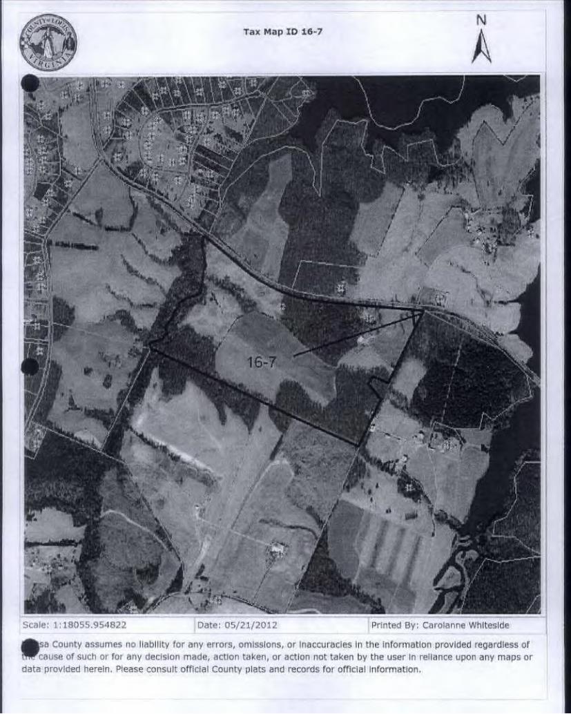
ScmW: i:iB055.#54@22 D*t»: 05/21/2012 nwrnmil ny rmiiWmiMim vmmmwnm
•sa County assumes no liability for any errors, omissions, or Inaccuracies In the Information provided regardless of cause of such or for any decision made, action taken, or action not taken by the user In reliance upon any maps or
data provided herein. Please consult official County plats and records for official information.
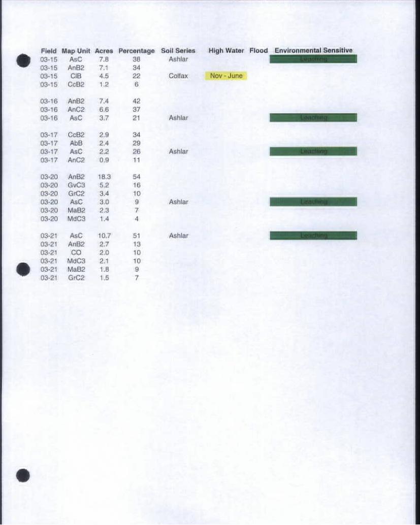
Field Map Unit Acres Percentage Soil Series 03-15 A*C 7.0 30 Ashlar 03-18 AnB2 7.1 34 03-15 cm 4U 22 Co#a* 03-16 CoBB 1.2 6
03-10 AnB2 7.4 40 03-10 AmCZ oa 87 03-10 A#C &7 21 Ashlar
03-17 CoB2 2 J 34 00-17 AbG 24 20 03-17 AmC Z2 m A * N * 03*17 AnC2 0\0 11
03-20 AoBB i&a 04 0340 OvC3 5.2 16 0340 GrC2 34 10 03-20 A*C 3^ 9 Ashlar 0340 Mmao 23 7 0340 Mdca 14 4
0341 A«C 10.7 51 AmN* 0341 AnK 2.7 13 0341 CO 10 10 0341 Mara 2.1 10 0341 MmB2 1.8 0 0341 G#C2 1.5 7
High Water Flood Environmental Sensit i
Nov - June
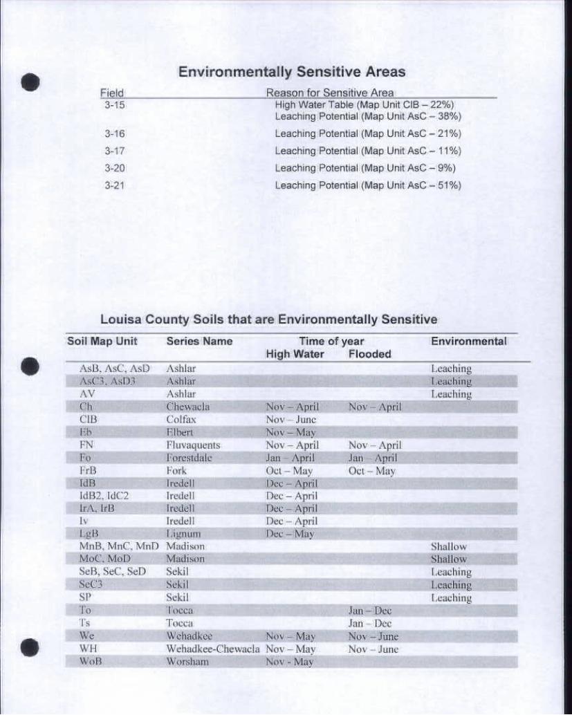
Environmentally Sensitive Areas Field Reason for Sensitive Area 3-15 r#ghW«&*Tm^(MmpUnmcm-22»)
Leaching Pi Aw WW (Map Un# AmC - 36%)
3-16 LmmcMngPoWW(MmpUnmAmC-21*)
3-17 LmmcNnoPoWnW(M»pUn#A«C-11*)
3-20 Leaching PiawaW (Map Un# AaC - 0* )
3-21 Leaching Potential (Map Unit AsC - 51%)
Lou isa County So i ls that are Env i ronmenta l ly Sensi t ive
Soil Map Unit Series Name Time of year Environmental High Water Flooded
AsB, AsC, AsD Ashlar Leaching [email protected] AWmar Iamokb* AV Ashlar Leaching
CIU CofAxx No% June • • • • F.lberl ITaTaTaTaV Nov-May S H H H H H
Fluvaquents Nov-April Nov - April Pa PommmWc Jma-AprU jam April FrB Fork Oct-May Oct-May WB Ing&dl Doc-ApA ldB2. IdCZ Iredell Dee - April
m ••••••••••i lv Iredell Dec-April L## 4Pum Dec - Wo\ MnB. MnC. MnD Madison Shallow MoC. MoD Madison Shallow SaB» SBC. SeD Sekil Leaching SeC3 Sekil Leaching ] • • SP SWoI Leaching To Tocca Jan - Dec Is Tocca Jap—D(# Wo Woaadaoo . Nov - May Mar-^aaa WH Wenadkce^fewacla Nov - May Nov - June Wol* Wonaaa* Nov - May
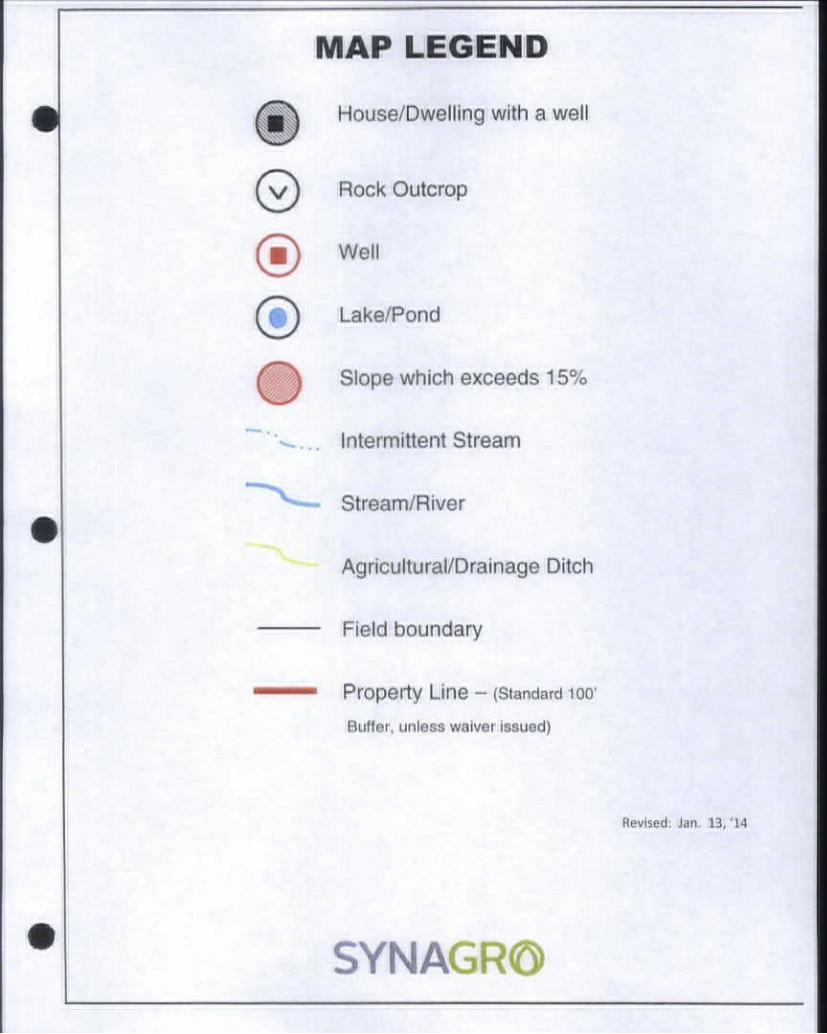
MAP LEGEND
House/Dwelling with a well
Rock Outcrop
(m) Well
Lake/Pond
Slope which exceeds 15%
Intermittent Stream
Stream/River
Agricultural/Drainage Ditch
Field boundary
Property Une - (9*andmrd iw Ek#T#f, urmmmm wmhwr kmumd)
Revised. Jan. 13, 14
SYNAGR©

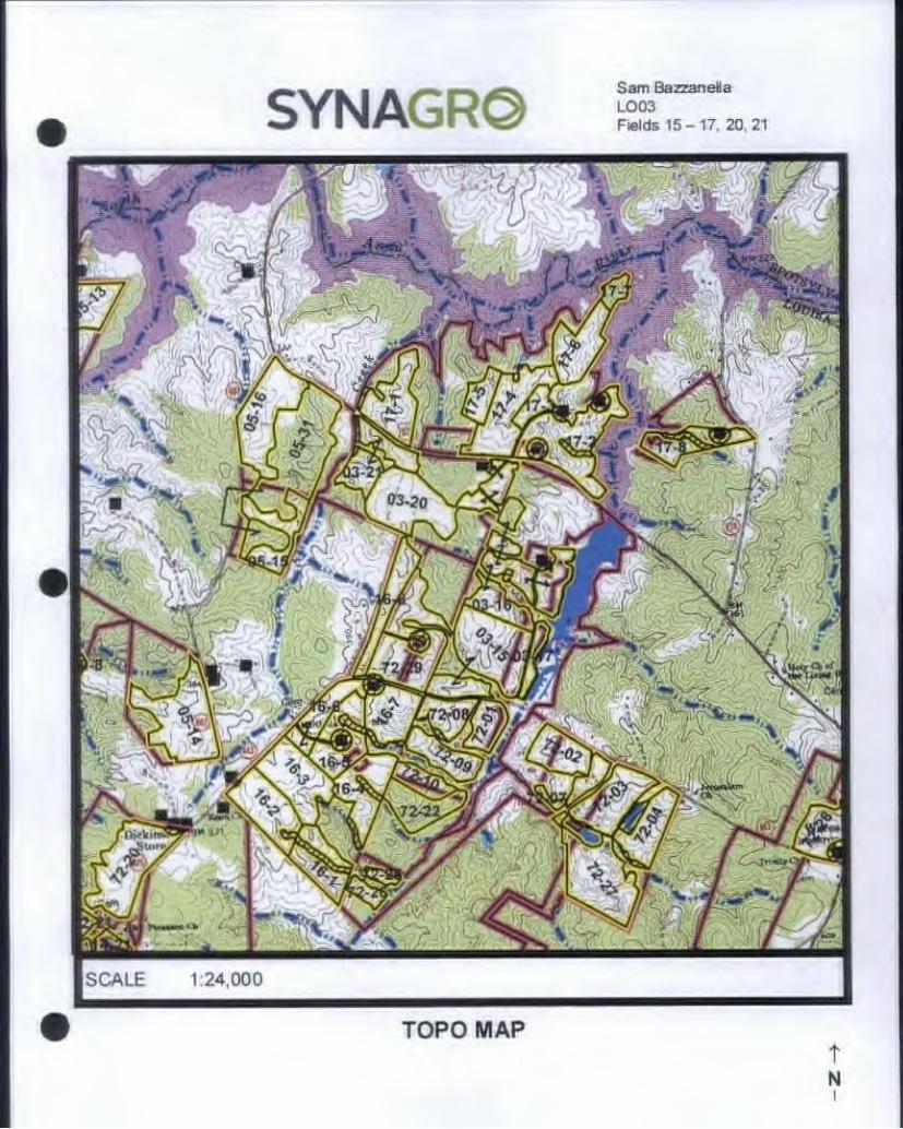
SYNAGR© Sam Bazzanella LOCO F*M* 15-17. 20.21
SOIL MAP
BBS Environmentally Sensitive Soil t N i

SCALE 1:9.000
TOPO MAP
# TOPO MAP T N i
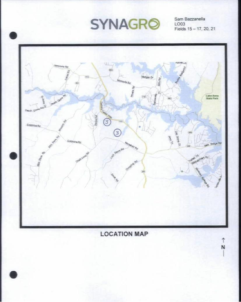
SYNAGR® Sam Bazzanella LCXB FWo* 15-17, 20,21
LOCATION MAP