Embed Size (px)
Citation preview

Interaction Between Roadwaysand Wildlife Ecology
A Synthesis of Highway Practice
NATIONALCOOPERATIVE HIGHWAYRESEARCHPROGRAMNCHRP
SYNTHESIS 305


NAT IONAL COOPERAT IVE H IGHWAY RESEARCH PROGRAM
NCHRP SYNTHESIS 305
Interaction Between Roadways andWildlife Ecology
A Synthesis of Highway Practice
CONSULTANTGARY L. EVINK
EcologistTallahassee, Florida
TOPIC PANEL
GREGG ERICKSON, California Department of TransportationPAUL GARRETT, Federal Highway AdministrationMARY E. GRAY, Federal Highway Administration
ALEX LEVY, Federal Highway AdministrationJOEL MARSHIK, Montana Department of TransportationPATRICK MCGOWEN, Western Transportation Institute
PAUL J. WAGNER, Washington State Department of TransportationJON WILLIAMS, Transportation Research Board
SUBJECT AREAS
Energy and Environment, and Safety and Human Performance
Research Sponsored by the American Association of State Highway and Transportation Officialsin Cooperation with the Federal Highway Administration
TRANSPORTATION RESEARCH BOARD — THE NATIONAL ACADEMIES
WASHINGTON, D.C.2002
www.TRB.org

NATIONAL COOPERATIVE HIGHWAY RESEARCH PROGRAM
Systematic, well-designed research provides the most effectiveapproach to the solution of many problems facing highway ad-ministrators and engineers. Often, highway problems are of localinterest and can best be studied by highway departments indi-vidually or in cooperation with their state universities and others.However, the accelerating growth of highway transportation de-velops increasingly complex problems of wide interest to high-way authorities. These problems are best studied through a coor-dinated program of cooperative research.
In recognition of these needs, the highway administrators ofthe American Association of State Highway and TransportationOfficials initiated in 1962 an objective national highway researchprogram employing modern scientific techniques. This programis supported on a continuing basis by funds from participatingmember states of the Association and it receives the full coopera-tion and support of the Federal Highway Administration, UnitedStates Department of Transportation.
The Transportation Research Board of the National ResearchCouncil was requested by the Association to administer the re-search program because of the Board’s recognized objectivityand understanding of modern research practices. The Board isuniquely suited for this purpose as it maintains an extensivecommittee structure from which authorities on any highwaytransportation subject may be drawn; it possesses avenues ofcommunication and cooperation with federal, state, and localgovernmental agencies, universities, and industry; its relationshipto the National Research Council is an insurance of objectivity; itmaintains a full-time research correlation staff of specialists inhighway transportation matters to bring the findings of researchdirectly to those who are in a position to use them.
The program is developed on the basis of research needsidentified by chief administrators of the highway and transporta-tion departments and by committees of AASHTO. Each year,specific areas of research needs to be included in the program areproposed to the National Research Council and the Board by theAmerican Association of State Highway and Transportation Offi-cials. Research projects to fulfill these needs are defined by theBoard, and qualified research agencies are selected from thosethat have submitted proposals. Administration and surveillance ofresearch contracts are the responsibilities of the National Re-search Council and the Transportation Research Board.
The needs for highway research are many, and the NationalCooperative Highway Research Program can make significantcontributions to the solution of highway transportation problemsof mutual concern to many responsible groups. The program,however, is intended to complement rather than to substitute foror duplicate other highway research programs.
NOTE: The Transportation Research Board, the National ResearchCouncil, the Federal Highway Administration, the American Associa-tion of State Highway and Transportation Officials, and the individ-ual states participating in the National Cooperative Highway Re-search Program do not endorse products or manufacturers. Trade ormanufacturers’ names appear herein solely because they are con-sidered essential to the object of this report.
NCHRP SYNTHESIS 305
Project 20-5 FY 2000 (Topic 32-11)ISSN 0547-5570ISBN 0-309-06923-8Library of Congress Control No. 2002111522
© 2002 Transportation Research Board
Price $16.00
NOTICE
The project that is the subject of this report was a part of the National Co-operative Highway Research Program conducted by the Transporta-tion Research Board with the approval of the Governing Board of theNational Research Council. Such approval reflects the Governing Board’sjudgment that the program concerned is of national importance and appro-priate with respect to both the purposes and resources of the National Re-search Council.
The members of the technical committee selected to monitor this proj-ect and to review this report were chosen for recognized scholarly com-petence and with due consideration for the balance of disciplines appro-priate to the project. The opinions and conclusions expressed or impliedare those of the research agency that performed the research, and, whilethey have been accepted as appropriate by the technical committee, theyare not necessarily those of the Transportation Research Board, the Na-tional Research Council, the American Association of State Highway andTransportation Officials, or the Federal Highway Administration of the U.S.Department of Transportation.
Each report is reviewed and accepted for publication by the technicalcommittee according to procedures established and monitored by theTransportation Research Board Executive Committee and the GoverningBoard of the National Research Council.
The National Research Council was established by the National Acad-emy of Sciences in 1916 to associate the broad community of science andtechnology with the Academy’s purposes of furthering knowledge and ofadvising the Federal Government. The Council has become the principaloperating agency of both the National Academy of Sciences and the Na-tional Academy of Engineering in the conduct of their services to thegovernment, the public, and the scientific and engineering communities. Itis administered jointly by both Academies and the Institute of Medicine.The National Academy of Engineering and the Institute of Medicine wereestablished in 1964 and 1970, respectively, under the charter of the Na-tional Academy of Sciences.
The Transportation Research Board evolved in 1974 from the High-way Research Board, which was established in 1920. The TRB incorpo-rates all former HRB activities and also performs additional functions un-der a broader scope involving all modes of transportation and theinteractions of transportation with society.
Published reports of the
NATIONAL COOPERATIVE HIGHWAY RESEARCH PROGRAM
are available from:
Transportation Research BoardBusiness Office500 Fifth StreetWashington, D.C. 20001
and can be ordered through the Internet at:
http://www.national-academies.org/trb/bookstore
Printed in the United States of America

PREFACE
FOREWORD By Staff TransportationResearch Board
A vast storehouse of information exists on nearly every subject of concern to highwayadministrators and engineers. Much of this information has resulted from both researchand the successful application of solutions to the problems faced by practitioners in theirdaily work. Because previously there has been no systematic means for compiling suchuseful information and making it available to the entire community, the American Asso-ciation of State Highway and Transportation Officials has, through the mechanism of theNational Cooperative Highway Research Program, authorized the Transportation Re-search Board to undertake a continuing project to search out and synthesize usefulknowledge from all available sources and to prepare documented reports on currentpractices in the subject areas of concern.
This synthesis series reports on various practices, making specific recommendationswhere appropriate but without the detailed directions usually found in handbooks or de-sign manuals. Nonetheless, these documents can serve similar purposes, for each is acompendium of the best knowledge available on those measures found to be the mostsuccessful in resolving specific problems. The extent to which these reports are usefulwill be tempered by the user’s knowledge and experience in the particular problem area.
This synthesis report will be of interest to state department of transportation (DOT)staff involved in the development, operation, and maintenance of roadways and how theycan effect wildlife and ecological systems across the country. Roadway developmentchoices made in response to population growth can affect many, if not all, forms of wild-life. Such effects include loss of wildlife habitat, fragmentation, mortality, and increasedcompetition. The synthesis reviews and discusses regulatory context (laws, regulations,policies, and guidance); transportation planning and development processes; the types ofeffects, including habitat loss, fragmentation, and chemical and physical impacts; thescale and assessment of effects; analytical tools, including motorist safety studies andwildlife surveys; conservation measures and mitigation; maintenance (culverts and habi-tat restoration); and funding sources and deficiencies.
Administrators, engineers, and researchers are continually faced with highway prob-lems on which much information exists, either in the form of reports or in terms of un-documented experience and practice. Unfortunately, this information often is scatteredand unevaluated and, as a consequence, in seeking solutions, full information on whathas been learned about a problem frequently is not assembled. Costly research findingsmay go unused, valuable experience may be overlooked, and full consideration may notbe given to available practices for solving or alleviating the problem. In an effort to cor-rect this situation, a continuing NCHRP project has the objective of reporting on com-mon highway problems and synthesizing available information. The synthesis reportsfrom this endeavor constitute an NCHRP publication series in which various forms ofrelevant information are assembled into single, concise documents pertaining to specifichighway problems or sets of closely related problems.
This report of the Transportation Research Board summarizes existing informationrelated to roadway planning, design, construction, operation, and maintenance practices

being used both nationally and internationally, successfully and unsuccessfully, to ac-commodate wildlife ecology given the challenging background of rapid growth and di-minishing natural resources. It includes data obtained from the survey responses of 35state DOTs in addition to a review of research literature to describe the state of the prac-tice. It reviews the processes, types of effects, analytical tools, conservation and mitiga-tion measures, maintenance, and funding involved in constructing an environmentallysustainable transportation system that acts in cooperation with the natural systems sup-porting our global civilization. Three case studies showing some actions being under-taken are provided. The report concludes with a listing and descriptions of the major fed-eral regulations relevant to wildlife and the environment.
To develop this synthesis in a comprehensive manner and to ensure inclusion of sig-nificant knowledge, the available information was assembled from numerous sources, in-cluding a large number of state highway and transportation departments. A topic panel ofexperts in the subject area was established to guide the author’s research in organizingand evaluating the collected data, and to review the final synthesis report.
This synthesis is an immediately useful document that records the practices that wereacceptable within the limitations of the knowledge available at the time of its preparation.As the processes of advancement continue, new knowledge can be expected to be addedto that now at hand.

CONTENTS
1 SUMMARY
5 CHAPTER ONE INTRODUCTIONBackground, 5Scope and Approach, 5
7 CHAPTER TWO REGULATORY CONTEXTOverview, 7Federal Perspective, 7State Perspective, 8
9 CHAPTER THREE TRANSPORTATION PLANNING AND DEVELOPMENT PROCESS
Avoidance and Minimization, 9Planning, 9NEPA Studies, 12Public Involvement, 14Engineering Studies, 14
16 CHAPTER FOUR TYPES OF EFFECTSFootprint and Physical Presence, 16Construction and Operational Aspects, 19Secondary and Cumulative Effects, 20
22 CHAPTER FIVE SCALE OF ASSESSMENT AND EFFECTSMicro-Ecology to Landscape Ecology, 22Organism’s Life-Cycle Requirements, 23
25 CHAPTER SIX ANALYTICAL TOOLS AND PROJECT MONITORINGMotorist Safety Study, 25Habitat and Wildlife Study Design, 25Study Elements, 25
29 CHAPTER SEVEN CONSERVATION MEASURES AND MITIGATIONStructural Techniques, 29Habitat Techniques, 41Programmatic Agreements, 42

44 CHAPTER EIGHT MAINTENANCE PROGRAMS FOR WILDLIFE MITIGATIONMaintenance of Structures, 44Habitat and Right-of-Way Maintenance, 45Maintenance and Management of Created, Modified,
or Restored Habitat, 46
47 CHAPTER NINE FUNDINGTransportation Equity Act for the 21st Century, 47Other Funding Sources, 47
49 CHAPTER TEN CASE STUDIESFlorida Case Study, 49Banff Case Study, 50US-93 Montana Planning Case Study, 52
54 CHAPTER ELEVEN CONCLUSIONS
56 REFERENCES
65 DEFINITIONS
68 ACRONYMS
69 APPENDIX A QUESTIONNAIRE RESPONSES
73 APPENDIX B LIST OF SURVEY RESPONDENTS
74 APPENDIX C MAJOR FEDERAL REGULATIONS RELEVANT TO WILDLIFEAND THE ENVIRONMENT
ACKNOWLEDGMENTS
Gary L. Evink, Ecologist, Tallahassee, Florida, was responsiblefor collection of the data and preparation of the report.
Valuable assistance in the preparation of this synthesis was pro-vided by the Topic Panel, consisting of Gregg Erickson, Senior Envi-ronmental Planner/Biologist, California Department of Transporta-tion; Paul Garrett, Ecologist, Federal Highway Administration,Lakewood, Colorado; Mary E. Gray, Environmental Program Manager,Federal Highway Administration, Idaho Division; Alex Levy, Ecologist,Federal Highway Administration, Atlanta, Georgia; Joel Marshik, Man-ager, Environmental Services, Montana Department of Transportation;Patrick MCGowen, Research Engineer, Western Transportation Institute;Paul J. Wagner, Biology Program Manager, Environmental Affairs Of-fice, Washington State Department of Transportation; and Jon Williams,Senior Program Officer, Transportation Research Board.
This study was managed by Jon Williams, Manager, SynthesisStudies, who worked with the consultant, the Topic Panel, and theProject 20-5 Committee in the development and review of the re-port. Assistance in project scope development was provided byDonna Vlasak, Senior Program Officer. Don Tippman was re-sponsible for editing and production. Cheryl Keith assisted inmeeting logistics and distribution of the questionnaire and draftreports.
Crawford F. Jencks, Manager, National Cooperative Highway Re-search Program, assisted the NCHRP 20-5 Committee and the Syn-thesis staff.
Information on current practice was provided by many highwayand transportation agencies. Their cooperation and assistance areappreciated.

INTERACTION BETWEEN ROADWAYS ANDWILDLIFE ECOLOGY
SUMMARY The challenges facing the transportation professional have never been greater. A centralchallenge is the need to maintain and enhance our environmental quality, because it influ-ences our quality of life and the very support systems required for life on this planet—air,water, and soil quality. There is sufficient evidence to show that through growth and inade-quate planning we have taxed some ecological systems, including the native habitats andwildlife populations in many areas of the country. This, in turn, has resulted in a variety ofpolicy initiatives and regulatory processes to address environmental concerns.
Federal and some state wildlife agencies are becoming more involved in transportationissues related to wildlife concerns, and numerous policy and regulatory programs are inplace to protect important habitats and wildlife. The FHWA, Environmental ProtectionAgency, U.S. Fish and Wildlife Service, National Marine Fisheries Service, and the U.S.Army Corps of Engineers at the federal level, and numerous state agencies through stateregulatory programs, are working together with the state transportation agencies to improvethe environmental quality of our transportation programs.
A survey conducted for this study indicates that although many states are attempting toaddress wildlife issues, most do not do so early in the transportation development process;that is, the planning stage. In some states, the environmental resource agencies lack suffi-cient staff to assist in early planning. The need for involving and training planners on envi-ronmental issues is evident.
Emerging issues such as habitat fragmentation and connectivity for wildlife, criticalhabitats, increasing numbers of threatened and endangered species, and secondary and cu-mulative impacts have further complicated matters for the transportation industry. Becauseof the linear nature of transportation projects, the potential for involvement with a variety ofhabitats and wildlife is high.
In some areas of the country where growth continues to encroach on native habitats, theexisting process is working, but not without difficulty. New alignment transportation proj-ects present unique issues because they can open up previously inaccessible areas, therebycausing associated changes in habitat quantity and quality. In some states, transportationagencies find their projects crossing some of the last remaining habitat, whereas in other ar-eas they may enter public lands being managed for wildlife values. Because of the magni-tude of potential impacts, this can prolong coordination of project issues. Avoidance andminimization of impacts are essential in some sensitive habitats.
When avoidance of impacts is not possible, the process of coordination among the trans-portation departments and the resource agencies is critical. Efforts are underway throughoutthe country to increase the staff that is available at these agencies through the transportation
2
agencies’ funding of resource agency positions. Concepts such as streamlining and context-sensitive design are helping to focus attention on the need for improving the coordinationprocess and for considering the environmental issues early in the process. Context-sensitivedesign is being used on very environmentally sensitive projects, such as US-93 in Montana,thereby helping work through environmental issues that might otherwise stop the project.The results of the survey indicated that if transportation departments address wildlife issuesearly in the planning process, this can contribute to streamlining the process.
One factor that has hindered the ability of the states to deal with wildlife issues is thelack of accepted methodologies for evaluating potential habitat and wildlife impacts and de-veloping mitigation strategies. Despite efforts such as the International Conferences onWildlife Ecology and Transportation and a number of research projects undertaken aroundthe country, no universally accepted methods have resulted. This has lead to the formationof a committee under the direction of the National Research Council’s Board of Environ-mental Studies and Toxicology to create a conceptual framework and approach for the de-velopment of a rapid assessment methodology that transportation agencies can use to assessand alleviate ecological impacts of road density.
Wildlife, wetlands, and ecosystem management are topics in a chapter in ConferenceProceedings No. 28: Environmental Research Needs in Transportation: Report of a Confer-ence (Transportation Research Board, The National Academies, Washington, D.C.). Imple-mentation of these research statements will be important. As states address wildlife interac-tions with roadways, effective techniques for evaluation of potential impacts to wildlife andhabitat from the species to landscape level, evaluation of secondary and cumulative impacts,and evaluation of the effectiveness of mitigation techniques will become increasingly im-portant.
Most states are evaluating habitat and wildlife impacts on their projects and in somecases have elevated the class of action to Environmental Assessment/Finding of No Signifi-cant Impact or an Environmental Impact Statement based on environmental issues, includ-ing wildlife. The level of concern expressed in the public involvement process has influ-enced the class of action. Coordination is also leading to satisfactory resolution of suchissues, with the result that the environmental features are being incorporated in many trans-portation projects across the country, including the restoration or preservation of habitat asmitigation and the addition of wildlife underpasses, overpasses, bridge extensions, enlargedculverts, and fencing by many states dealing with the realities of wildlife conservation andmotorist safety. From a wildlife conservation perspective, the impacts addressed includehabitat loss, habitat fragmentation, degradation of habitat quality, road avoidance zones, in-creased human activities, direct mortality, reduced biodiversity, genetic isolation, chemicalcontamination, changed hydrology for fisheries, reduced access to vital habitat, disruptionof processes important to animal life cycles, and disruption of the food chain. The measuresbeing taken by the states are designed to help remedy these impacts. The technology to fullyevaluate the effectiveness of the various measures is available, but is not widely used. In-stead, simple, nonanalytic monitoring methods are employed to determine the success ofinitiatives to accommodate wildlife ecology.
Habitat-related mitigation and conservation measures are being used to address thebroader ecological concerns associated with reductions in habitat and wildlife connectivity.In combination with fencing and crossing structures, these measures are believed to be themost effective by the regulatory agencies and advocacy groups, although long-term researchon these measures is currently insufficient.

3
From a motorist safety perspective, the number of collisions with wildlife and the humaninjury and fatality associated with these accidents, as well as the financial costs, are signifi-cant. Indications are that the number of accidents is increasing. However, in areas wherethese impacts were comprehensively addressed, wildlife collisions have almost been elimi-nated. Over the long term, the savings associated with reduced human injury/mortality andvehicular damage could offset the cost of mitigation measures.
In recent years, most states have anticipated these costs. Some states have even set upseparate funding mechanisms for mitigation to ensure that the costs do not disrupt the workprogram. However, there is need for additional funding to remedy those existing situationson highways with no improvements programmed for the future through retrofit. Some statesare also having problems justifying habitat and wildlife mitigation that is not associated withlisted species, because there is no regulatory imperative. However, many states are now ad-dressing the broader habitat and wildlife issues as part of the affected environmental analy-sis and providing measures to avoid, minimize, or mitigate those impacts despite the lack ofregulatory imperative.
In Europe and Canada transportation agencies address habitat and wildlife issues byplacing the emphasis on the larger landscape planning that provides wildlife habitat and re-lated measures to complement transportation system planning. In Europe, a plan is beingdeveloped for habitat connectivity throughout their transportation system that involves in-ternational cooperation among most European nations. This plan inspired a Wildlife Mor-tality Study Tour sponsored by AASHTO and the FHWA International Outreach Programfor technology transfer. The result was a report that documents the successes of the Europe-ans as a result of these efforts. The research conducted on these activities could help statetransportation agencies better understand the possibilities of such planning.
Although positive things are happening, they are happening slowly. However, the direc-tion is toward increasing acceptance of the need to consider wildlife-related issues and con-tinued improvement of efforts to address these issues. Wildlife measures compete with all ofthe other transportation needs for funding. Consequently, dedicated funding would help toexpedite the intentions of the context-sensitive design and streamlining initiatives throughearly planning and commitment of funding for ecological and wildlife measures.

5
CHAPTER ONE
INTRODUCTION
In the end, we will conserve only what we love, we will love only what we understand, we will under-stand only what we are taught. Bada Dioum, Senegal
BACKGROUND
Although the interactions between wildlife ecology androadways have only recently received national and inter-national attention, the origins of these relationships dateback to when the first roadways (trails) opened this countryto human habitation. Since those early days, the need forhumans to have access and mobility has resulted in a pri-mary road system of approximately 4 million miles (Cookand Daggett 1995). Approximately three-quarters of thismileage is in rural areas, where most of the remainingwildlife habitat is located. Using an average of 5 acres permile, Cook and Daggett estimated that highways, streets,and rights-of-way have eliminated approximately 20 mil-lion acres of habitat.
Transportation development in this country creates greatchallenges for wildlife conservation. The reasons for thisare (1) private lands are being developed at an unprece-dented rate; (2) agriculture, urban sprawl, and industry areencroaching on natural areas (Flather et al. 1999), and (3)management of public lands has lead to the loss of impor-tant habitats and associated species. Modern demands formobility and access have resulted in a built-up demand fortransportation infrastructure. Although the transportationindustry tries to move to a more diverse modal mix, theautomobile continues to be the public’s preferred mode oftransportation. In this environment, the transportation in-dustry is struggling to satisfy the mandate to provide safeand efficient transportation in an environmentally soundmanner. The challenge is to build an environmentally sus-tainable transportation system and other human infra-structure that does not permanently damage the naturalsystems that support our global civilization.
SCOPE AND APPROACH
This synthesis study reviews the interactions that occurduring the planning, design, construction, operation, andmaintenance of roadways that can affect ecological sys-tems and wildlife. A questionnaire was used to determinehow the state departments of transportation (DOTs) are ad-dressing ecological and wildlife-related matters given thischallenging background of rapid growth and diminishing
natural resources. Information obtained from the 35 stateDOTs that responded to the survey, along with a review ofresearch literature, is used to describe the state of the prac-tice. Survey results are intended to provide qualitative in-formation about processes, types of effects, analyticaltools, conservation/mitigation measures, maintenance, andfunding involved in coordinating transportation planningwith potential habitat and wildlife impacts.
Chapter 2 reviews the regulatory context in which thestate DOTs are carrying out their mandate to provide a safeand efficient transportation system in an environmentallysound manner. This chapter presents an overview of theprimary local, state, and federal regulations that the statesfelt to be the most important in their survey responses.(Appendix C contains an annotated listing of the primaryfederal regulations with relevance to wildlife and the envi-ronment.) The planning and project development processused to address the regulations is discussed in chapter 3.This chapter reviews avoidance and minimization, plan-ning, National Environmental Policy Act (NEPA) studies,public involvement, and engineering studies as relates towildlife. The types of effects that transportation facilitiesand activities can have on wildlife are covered in chapter 4.The topics are divided into those related to footprint andphysical presence, those related to construction and opera-tional aspects, and secondary and cumulative effects. Be-cause of the linear nature of most transportation facilities,the scale of assessment needed and resulting effects cancover a wide spectrum; this is covered in chapter 5. Ana-lytical tools such as motorist safety studies and wild-life/habitat studies presented from the state surveys and lit-erature review are contained in chapter 6. The conservationand mitigation measures, successful and unsuccessful, ob-tained from a state survey are discussed in chapter 7. Re-cent approaches such as programmatic agreements, as wellas standard structural and habitat techniques are described.The maintenance of structures and habitat by the transpor-tation departments is examined in chapter 8. Chapter 9 is alook at the funding sources and funding deficiencies identi-fied during the state survey. Chapter 10 contains three casestudies that demonstrate some of the actions being taken.The Florida case study examines the results of a statewideeffort by the state transportation agency to address wildlifeconcerns. The Banff case study is an example of providing

6
connectivity through a major highway corridor in a na-tional park setting. The significant planning and public in-volvement process used to arrive at project concepts forU.S. Highway 93 in Montana is the third case study. Theconclusions of the synthesis study are contained in chapter11. A Glossary providing the definition of terms not nor-mally recognized and a section on nomenclature (acronyms)are provided at the end of the report. In addition, Appendix Acontains the responses to the questionnaire and the states
that responded to the questionnaire are listed in AppendixB. Appendix C provides a listing and description of theprimary federal regulations that are relevant to wildlife andthe environment.
A continuously updated source of information on thelatest activities in the area of wildlife in transportation canbe found at the website for the Center for Transportationand the Environment (www.itre.ncsu.edu/cte/wildlife.htm).

7
CHAPTER TWO
REGULATORY CONTEXT
OVERVIEW
Many of the actions of transportation agencies are in reac-tion to federal and state laws. Therefore, it is important tohave at least a basic understanding of the applicable lawsbefore looking at the elements of compliance—process,analysis of impacts, conservation measures/mitigation,and funding. This chapter is not intended to be an ex-haustive discussion of regulations related to wildlife andtransportation, but rather is meant to familiarize thereader with the important wildlife-related legal obliga-tions that individuals involved in advancing transporta-tion projects must consider. Although these require-ments do not vary at the federal level, each state can haveregulations that complement or expand the responsibilitiesunder federal regulations. It is important that persons in-volved in transportation development understand thesepolicy directives and legal requirements to address wildlifeand habitat considerations. Survey respondents cited thefollowing environmental regulations as those they mostoften encountered:
• National Environmental Policy Act (NEPA), PublicLaw No. 91-190.
• Clean Water Act of 1977, Sections 401 and 404.• Endangered Species Act of 1973, as amended, 16
USC 1531 et seq.• Coastal Zone Act Reauthorization Amendments of
1990—Section 6217.• Coastal Resources Management Program—October
1987.• Federal Coastal Zone Management Act of 1972, P.L.
92-583, as amended.• Section 4(f) Evaluations and Approvals for Federally-
Aided Highway Projects with Minor Involvementwith Public Parks, Recreations Lands, Wildlife andWaterfowl Refuges and Historic Sites, December 23,1986—49 USC 303.
• Migratory Bird Treaty Act.• Fish and Wildlife Coordination Act.
All environmental factors associated with transportationprojects can have an impact on wildlife. Therefore, theregulations dealing with the elements of the environment(air, noise, water, etc.) were reviewed for this study and areincluded in this chapter. The relationships of these ele-ments to wildlife ecology will be developed in the comingchapters.
With the exception of the discussion of state and localregulations, which were identified by a survey of the states,the following is taken from the FHWA publication on theregulatory context (FHWA 1990).
An excellent source of information on environmentallegal problems arising from highway programs is “High-ways and the Environment: Resource Protection and theFederal Highway Program” (NCHRP 1994).
FEDERAL PERSPECTIVE
Since Congress adopted the National Environmental PolicyAct (NEPA) in 1969, the FHWA has built policies and pro-cedures to help meet its social, economic, and environ-mental responsibilities while accomplishing its transporta-tion mission. The FHWA Environmental Policy Statement(EPS) is a formal expression of the FHWA’s commitmentto the protection and enhancement of the environment. TheFHWA provides the policy grounds and associated proce-dures for the development of environmentally sound proj-ects. It is the responsibility of the state transportation agen-cies to meet these standards. For the purposes of this study,it is necessary to understand which elements of the policyapply to federal-aid projects. The following are some ofthe key elements of the policy:
• Defining the “environment” to include the natural andbuilt environment;
• Consideration of effective communication as criticalto success by empowering diverse interests;
• Encouragement of broad-based public involvementearly and continuously in the process;
• Integration of environmental goals and impacts by lo-cal, regional, and state land-use planning;
• Promotion of multi-modal solutions to transportationand air quality problems;
• Promotion and support of travel alternatives to single-occupancy vehicle use—mass transit, etc.
• Coordination of planning to conform with air qualityimplementation plans;
• Promotion and support of watershed planning;• Encouragement of corridor preservation to ensure
early consideration of environmentally sensitiveareas;
• Support for federal, state, and local efforts to controlnoise emissions;

8
• Encouragement of continual consideration of envi-ronmental factors throughout all phases of project;
• Consideration of social, economic, and environmentalissues equally with engineering issues;
• Support for the merger of NEPA with other environ-mental reviews and decisions—permits;
• Support for an interdisciplinary approach;• Requirement of full consideration of avoidance,
minimization, and mitigation of adverse impacts;• Encouragement of enhancement of the natural and
human environment;• Requirement of environmental commitment compli-
ance and implementation;• Requirement of full compliance with environmental
protection laws, regulations, executive orders, andpolicies;
• Encouragement of mandates going beyond compli-ance to strive for environmental excellence;
• Support for research and development to raise thelevel of expertise to state of the art; and
• Support for environmental training to develop envi-ronmental professionals in transportation.
It is clear from the FHWA environmental policy that anenvironmentally sound transportation system is the goal.The challenge is for the states to achieve this goal underthe federal-aid transportation program.
An annotated list of major federal regulations that arerelevant to wildlife and the environment can be found inAppendix C.
STATE PERSPECTIVE
The majority of respondents have either state law (22states), planning requirements (9 states), policies (14states), procedures (15 states), and even court decisions (3states) requiring that they address ecological impacts. For astate to assume a regulatory program, their regulationsmust match or exceed the federal standards. (Note that fed-eral law takes precedent over state law, especially as relatesto projects involving federal funds.)
Several states have NEPA-like requirements similar tothe federal requirements; California has the California En-vironmental Quality Act; Georgia an Environmental PolicyAct; Maine a Natural Resources Protection Act; andWashington a State Environmental Protection Act.
States reporting wetland protection requirements in-clude Connecticut, Ohio, Oregon, Virginia, and Wisconsin.Nebraska and Oregon have state protection of endangeredspecies. Several states described special state provisionsfor fisheries including Alaska, Colorado, Maine, Ohio, andWashington.

9
CHAPTER THREE
TRANSPORTATION PLANNING AND DEVELOPMENT PROCESS
The following is not an explanation of how each of theplanning, project development, and environmental docu-ments are prepared, but rather an explanation of the im-portance of each to wildlife ecology and transportation.Where appropriate, references are given that more fullydiscuss the composition of these documents and how theyare processed.
AVOIDANCE AND MINIMIZATION
Avoidance negates impacts to habitat and therefore wild-life, whereas minimization reduces the impact to levels thatcan often avoid or reduce mitigation. In conjunction withthe basic transportation needs analysis, this is a primaryobjective of the analysis process. State transportationagencies felt that the regulatory agencies are reluctant tobecome involved in interagency coordination unless avoid-ance and minimization is demonstrated. When they do be-come involved, their first input is how to avoid or mini-mize impacts. Development of a transportation systemwithout adequate considerations for avoidance and mini-mization can result in long, drawn-out negotiations withthe resource agencies. The states reported that demonstra-tion of avoidance and minimization moves the coordina-tion process along as mandated in the streamlining provi-sion in the Transportation Equity Act for the 21st Century(TEA-21).
PLANNING
Unless the planner and the planning process are sensitiveto the environmental ramifications of their actions, con-tinuing problems in advancing transportation projects,continuing reduction of quality of life, and continuing re-ductions in native habitats and their associated wildlife willoccur. The states indicated a need for environmental train-ing of planners. The following account of transportationplanning is a modified version of information contained onthe FHWA website (www.fhwa.gov/planning). A morecomprehensive treatment is contained on the website.
Provisions of TEA-21 require that transportation plan-ners, highway officials, and transit interests recognize en-vironmental values and incorporate environmental protec-tion and enhancement measures into programs to developand improve the nation’s surface transportation system.TEA-21 establishes planning as a pivotal strategy in the
cooperative approach for financing needed improvementsin the nation’s transportation infrastructure while main-taining and enhancing the environment. The federal trans-portation act (currently TEA-21) is a federal-aid programwherein state and local governments finance needed trans-portation improvements with the use of federal funds madeavailable from taxes collected primarily through the sale ofgasoline. Under this funding arrangement, the state DOTsand the metropolitan planning organizations (MPOs) planhighway and transit improvements through the use of anintegrated process that includes environmental studies.This results in long-term highway construction programsof projects needed to support the current and future move-ment of people and goods. Although mobility improve-ments are the focus, the planning process envisioned by TEA-21 also includes participation by the public and private sectorsto support other quality of life objectives. The process incor-porates a variety of elements, including environmentalprotection and enhancement coupled with accessibility to,and equity in, the provision of transportation services.Collectively, these and other elements of the planning pro-cess can fit together to help meet a variety of local needsand national priorities including environmental programs.
The transportation planning agencies determine theoverall, best way to solve a particular mobility problem af-fecting the planning area. Information on land-use plan-ning/environmental goals, zoning objectives, and resourceprotection and management priorities need to be incorpo-rated. This is necessary to ensure that transportation im-provement proposals are relevant to public needs and con-sistent with other environmental planning efforts occurringin the same area. Land-use and environmental informationneed to be similar in scale. Therefore, corridor-scale, re-gional, and other area-wide information sources are mostappropriate. This level of planning is consistent with theneeds for landscape level ecological planning needed forwildlife.
System Planning Studies
The FHWA and a number of state transportation agencieshave recognized the need to consider environmental issuesearly in the planning process. In several states, the successof streamlining the environmental process during projectdevelopment and environment studies has depended ongetting environmental considerations into the process at thesystems planning stage so that coordination leads to resolution

10
prior to the Project Development & Environment (PD&E)stage. System planning is the point at which connectivityfor wildlife can be evaluated. At the systems level, the cu-mulative effect of the highways on the landscape can bedetermined and measures taken to demonstrate avoidanceand minimization of environmental impacts to importantecological areas. These considerations then can be appliedto the entire system rather than individual projects. Envi-ronmentally poor corridor selections can be identified atthis stage of planning and coordination carried out to de-termine whether moving forward to the project stage is inthe best public interest. This is part of the balanced ap-proach that is mandated in TEA-21.
Local Growth Management Plans
Local land-use planning is another area where considera-tion of environmental factors that involve native habitatsand wildlife is important. Over the past several decades,urban growth has consumed millions of acres of habitat,with associated reductions in wildlife populations (Flatheret al. 1999). Local land-use plans facilitate growth for eco-nomic motives. Frequently, environmental impacts do notbecome a consideration until the quality of life in the areais threatened by the reduction in environmental quality.MPOs and DOTs are responsible for ensuring coordinationbetween land use and transportation plans involving envi-ronmental impacts. Avoidance and minimization of im-pacts to the remaining important ecological areas must bean important factor. Indeed, in some areas restoration ofhabitats already affected can be a part of the local growthand transportation planning process to restore diminishednative habitats and wildlife populations.
Metropolitan Planning Organizations
MPOs can become primary players in the initial review ofthe environmental considerations associated with varioustransportation options of urban transportation planning.Early coordination between MPOs and environmentalagencies can help prevent environmentally damaging proj-ects. Transportation departments around the country arefinding it increasingly difficult to advance environmentallysensitive projects previously identified by MPOs in thelocal transportation planning process. For many habitatsand species, a critical point has been reached and theMPOs can play an important early role in the transporta-tion connection.
Transportation Plans
The use of planning leads to the creation of transportationplans. At this early stage coordination should begin on
projects that have the potential to impact wildlife, becausethis is when plans can still be changed. It is at this point thatfunding considerations begin and, if features are anticipatedfor a project, money can be programmed. This is the opportu-nity to change environmentally sensitive plans. Citizen’sawareness and their resulting participation in the transpor-tation planning process are increasing (McMurtray 2002).
Environmental Resource Agency Plans
The environmental information needed for reviewing thetransportation system and projects is often contained in en-vironmental resource agency plans. These plans are the re-sult of studies that include public involvement and reflectthe environmental point of view. This can also be a sourceof geographic information system (GIS) information thatcan be applied at the systems and project stage. Whenpassing near or through resource agency lands, it is im-portant that the goals of these resource management plansbe part of the transportation planning process. Section 4(f)of the Department of Transportation Act, which requiresthe analysis of avoidance when impacting certain parksand recreation areas, can apply if the transportation projectconflicts with the management goals as relates to recrea-tion. Facilitating public transportation is not a priority forthese public lands; therefore, avoidance and minimizationis important. Unfortunately, resource agency plans, liketransportation plans, often lack the coordination with otheragencies and agency plans that would lead to better im-plementation of all plans. This cannot be done by trans-portation agencies at the project development and envi-ronmental studies phase of individual projects. However,survey results indicate that this is the point at which mostcoordination is presently taking place. If sustainability ofenvironmental quality is the goal, it will take early coordi-nation of all of the plans.
Endangered Species Recovery Plans
When wildlife and their habitats become part of an endan-gered species recovery plan, it signals that previous plan-ning and management for these species has failed. Some ofthis can be attributed to loss of habitat on private landspreviously used by the species, but the management of ourpublic lands has also contributed. If public lands are notbeing managed to protect these important wildlife re-sources, the expenditure of funds for wildlife features onour transportation systems will do little to ensuresustainability of these habitats and associated wildlife. Thisis especially true for the large carnivores that require sig-nificant areas of habitat that cross international boundaries.
The states surveyed responded that transportation ele-ments are increasingly becoming a part of endangered species

11
recovery plans because highway mortality can be problem-atic. In the case of the Florida panther, these highway fea-tures were included in the U.S. Fish and Wildlife Servicerecovery plan for the panther and are proving successful atreducing mortality in the immediate area of the structureson I-75 and SR-29. Unfortunately, the same measures havenot been taken on county and private roads, so that high-way mortality continues to be a factor in what seems to bean increasing population of mixed Texas cougars andFlorida panthers. Transportation measures to protect theFlorida panther in south Florida will do little to ensurethe continued existence of this species if public landmanagement in the area cannot help sustain the popula-tion. It has become apparent that in developing areas ofthe country, private land cannot be counted on as part ofthe long-term strategy to sustain these often-controversialspecies.
Measures taken to protect endangered species also helpprotect the other remaining wildlife so that the expenditureof public funds is often justified; however, in the cost-effectiveness analysis of what measures are taken on ahighway plan or project, the long-term sustainability of en-dangered species needs realistic consideration. Transporta-tion is but one factor in the consideration of endangeredspecies. Mortality reduction on the transportation systemwill not, by itself, save any of these species.
Regardless, many endangered species recovery planscontain transportation elements and the highways are animportant part of the recovery process for numerous spe-cies. Therefore, transportation planners and environmentalscientists need to use the information contained in the re-covery plans when developing associated transportationplans and projects.
Other Planning Related Studies
A more complete approach to habitat and wildlife consid-erations in relation to highways can be derived fromviewing total landscapes that include numerous ecosystemsand associated wildlife. Ruediger et al. (1999) examinedkey linkage areas for carnivores in three western states—Montana, Idaho, and Wyoming. They argue that theprogressive improvement of roads from gravel forest roadsto Interstate highways has increasingly separated largeareas of important habitat, thereby adversely affectingcarnivores and other wildlife species. Sixty-four highwayswere identified as important linkage areas, with 20 of thesedescribed as “high priority.” This information, supportedby additional studies, could be a way to addressconnectivity problems for carnivores and therefore allwildlife in these important areas. A systems level approachfor highways is also taken by Servheen et al. (2001) andRuediger et al. (2000).
An understanding of the relationship of the transporta-tion system to wildlife populations in a given area is criticalto early planning. Numerous studies to support the decision-making process have been done. In Colorado, two majortransportation corridors (I-25 and US-85) were studied toidentify those species crossing the highways and to better un-derstand habitat connectivity needs across these corridors(Henke et al. 2002). The study looked at surrounding publiclands and documented movement through existing structuresand over the highway. Deer and elk were recorded crossingthe highways “at-grade.” Movement appeared to be correlatedto drainages, topography, and habitat. A wide variety ofwildlife was using existing drainage structures.
Barnum (2002) studied wildlife crossing sections of twohighways (US-24 and I-70) in the southern Rocky Moun-tains. The study documented at-grade crossings andmovement through existing dry wash drainage structures.Results indicate that wildlife use existing structures andthat locations where wildlife cross the highways are relatedto topographic and habitat features in the area. Craigheadet al. (2002) looked at wildlife linkage and highway safetyin the Bozeman Pass area of Montana, which includes theI-90 corridor. The study identified problem areas and maderecommendations about how and where to mitigate mor-tality and human safety issues.
In Washington, Singleton and Lehmkuhl (1999) took anatural system level approach to looking at InterstateHighway 90 from Snoqualmie Pass to Cle Elum. Theyused a GIS “least-cost path” modeling of landscape pat-terns to identify important linkage areas for sensitive spe-cies. They also did a GIS-based analysis of ungulate road-kill distribution and monitored existing structures forwildlife movement. Automatic cameras and winter snowtrack surveys were done to look at animal distributionalong the highway. The information obtained is being usedto determine the need and placement of wildlife mitigationmeasures. Singleton et al. (2002) also used a weighteddistance and least-cost corridor analysis technique toevaluate regional scale large carnivore habitat connectivityneeds in Washington. They identified six concentrations oflarge carnivore habitat and four landscape linkage areas ofpotential importance to these populations.
Similar studies have been done in Canada. Gibeau et al.(2002) studied the effects of highways on grizzly bear move-ment in the Bow River Watershed in Alberta, Canada. Usingradiotelemetry data, they found that one highway in the areawas effectively a barrier. They did find that the bears cross thehighways in specific enough locations that recommendationson crossing zones are possible with sufficient data.
Demarchi (2002) evaluated the spatial extent,magnitude, and duration of adverse effects to grizzly bearsassociated with an all-season gravel road between

12
Greenville and Kincolith, British Columbia. The result ofstudies by the provincial and federal environmentalassessment authorities was a 10-year monitoring programdesigned to look at impacts to the bears from the project.
At the individual species level, the Washington DOT isfinancing studies of the spotted frog (proposed for listing)and lynx to obtain basic biological information for use infuture planning and project activities.
Studies such as those cited previously, which seek tobetter understand wildlife populations and movement inthe area of highways, will help transportation agencies inthe planning of transportation improvements. This will alsoincrease the probability that wildlife will be an importantpart of that planning process because of the knowledgegained from the studies.
Only a few states have looked at their entire highwaysystems in relation to wildlife ecology. Florida contractedthe University of Florida to conduct a statewide study tohelp identify highways needing more detailed study in re-lation to wildlife. Smith (1999) used a rule-based GISmodel to perform this function. Chronic roadkill sites, fo-cal species hot spots, riparian corridors, greenway link-ages, strategic habitat conservation areas, existing and pro-posed conservation lands, and movement/migration routeswere used to prioritize areas of highways needing consid-eration. The areas identified were regionally and nationallysignificant conservation areas and important riparian corri-dors. Presently, the areas identified as priority areas arebeing examined for existing structures (bridges, culverts,overpasses, etc.) that might facilitate wildlife movement.Other high-priority areas are being studied for mitigationmeasures. Gilbert et al. (2002) did a GIS-based analysisto prioritize black bear roadkill problem areas in Floridaand found that 34% of the kills had occurred at 15chronic problem areas. Using information from thesestatewide studies, the Florida DOT is able to study the ne-cessity of features in projects in the work program or toprogram wildlife mitigation retrofit projects in high-priority areas.
In 2001, The Los Angeles Times reported that more than300 wildlife corridors had been identified as vital to Cali-fornia’s wildlife populations. A team of 160 experts frompublic agencies, advocacy groups, consulting firms, andacademia looked at wildlife linkage zones throughout Cali-fornia and identified these corridors as necessary to pre-vent fragmented islands of habitat in a sea of development.The information will help state and federal efforts to pur-chase habitat and provide connectivity across the state’stransportation system.
These system level studies for environmentally soundtransportation planning indicate a national need. Much data
exist at preliminary levels that could be used to identifylinkage area needs for the entire primary and Interstatehighway system of the United States. In this way, other in-terstate wildlife connectivity needs can be identified, suchas those documented by Paquet (1995) for the WyomingRange in Wyoming to Jasper National Park in Canada.Having the large-scale needs identified, land-use andhabitat studies similar to those done in Florida could fur-ther refine the information. Project-level decisions requirelandscape-level studies similar to those in SnoqualmiePass, Washington. Only by integrating project-level deci-sions with system-wide studies can transportation agenciesaddress the larger connectivity needs of diminishingpopulations of the larger wildlife species.
Colorado is taking an innovative approach. On corridorswith successive highway projects, individual projectevaluations often result in replication of environmental im-pact studies. Therefore, Colorado’s initiative, a CorridorStreamlining Evaluation Project, is developing a methodfor evaluating potential impacts to resources from futureprojects at the corridor level and during project planning.By conducting studies at the corridor level, several projectscan be comprehensively evaluated, saving time and re-sources, and reducing both redundancy and the number ofstudies needed. A pilot study is currently being completedfor State Highway 24 to evaluate the use of aerial imageryand remote sensing technology to accurately map envi-ronmental resources. Future pilot studies are planned. Thisstudy, which is building on previous efforts to map wet-lands with infrared photography, mapped plant communi-ties, sensitive species habitats, wildlife corridors, historicaland archaeological resources, and hazardous waste sites. Inaddition, a refined application of this technology is beingused on the US-285 transportation corridor to support aproject feasibility study and environmental documentation.Using remotely sensed data to identify lynx habitat andmodel probable lynx dispersal routes, the best sites for lo-cating crossing structures can be identified. Overall, theCorridor Streamlining Evaluation Project will allow Colo-rado to map geographic information and collect environ-mental data accurately while projects are still in conceptualdevelopment. Base maps and collected data will help Colo-rado decide on project design and develop cumulative im-pact assessments, as well as to anticipate and identify miti-gation needs and opportunities.
NEPA STUDIES
The National Environmental Policy Act of 1969 (NEPA)includes three major goals: (1) It sets national environ-mental policy, (2) it established a basis for environmentalimpact statements (EISs), and (3) it created the Council onEnvironmental Quality (CEQ), which has oversight andinterpretation responsibilities. NEPA requires that, to the
13
extent possible, the policies, regulations, and laws of thefederal government be interpreted and administered in ac-cordance with the protection goals of the law. It also re-quires federal agencies to use an interdisciplinary approachin planning and decision making for actions that impact theenvironment. NEPA also requires the preparation of an EISon all major federal actions significantly affecting the hu-man environment.
NEPA has affected all federal agencies, including theFHWA. NEPA requires and the FHWA is committed to theexamination and consideration of potential impacts on sen-sitive social and environmental resources when consider-ing the approval of a proposed transportation facility. Inaddition to responsibilities for examining and consideringenvironmental effects, transportation agencies must alsoaddress the transportation needs of the public. The FHWANEPA project development process is a balanced approachto transportation decision making that takes into accountthe potential impacts on the human and natural resourcesand the public’s need for safe and efficient transportationimprovements.
It is the FHWA’s policy (The Federal Highway Admini-stration’s . . . 1990) that all environmental protection re-quirements and enhancement goals be completed as part ofa coordinated review process that includes and considersthe input of other agencies and the public through estab-lished coordination and a public involvement process. Thestates must provide evidence of compliance or a reasonableassurance that compliance will be attained.
Project Development and Environmental Studies
Project Development and Environmental Studies are theNEPA compliance documents for transportation projectsthat have made it through the planning process. Althoughthe “no project” or “no build” alternative is always consid-ered in the analysis, funding and other forces are in placethat usually lead to project development. Therefore, theProject Development and Environmental studies [eitherEnvironmental Assessment/Finding of No Significant Im-pact (EA/FONSI) or EIS] are where environmental factorsare documented so that the planned project can advance.
In recent years, the “categorical exclusion” has becomea more common means of advancing projects. Althoughcategorical exclusions can greatly accelerate project ap-provals and implementation, the level of study for habitatand wildlife aspects of the project should not diminish. Toqualify as a categorical exclusion, the results of these andother studies related to the project must conclude that thereare no significant impacts. This often leads to resolution ofhabitat and wildlife issues during the studies with any nec-essary mitigation, so that all stakeholders agree that thereare no significant impacts.
The complexity of issues or controversy involved with aproject may necessitate more extensive documentation ofthe factors involved in a project. The level of appropriatedocumentation is identified in a Class of Action Determi-nation between the state DOT and FHWA and is based onearly information and inputs on the project. Most re-sponding states (22) reported that ecological considerationsnecessitate documentation under either an EA/FONSI orEIS—an indication that these issues are getting the properlevel of attention.
Similar to the categorical exclusion, the end result of anEA/FONSI is the finding that a balanced project has nosignificant impacts. EA studies, which tend to be more ex-tensive than in a categorical exclusion, are conducted to ar-rive at this conclusion. If a FONSI can not be supported atthe EA level, the study is elevated to an even higher levelof scrutiny in an EIS. In either case, for the project to ad-vance, the impacts must be addressed and, where neces-sary, suitable mitigation provided. In an effort to keep thelength of environmental documents reasonable, some ofthe issue areas are studied in separate reports that aresummarized in the environmental document.
Endangered Species Consultation
Each Federal agency shall, in consultation with and with theassistance of the Secretary (of the Department of Interior), in-sure that any action authorized, funded, or carried out by suchagency…is not likely to jeopardize the continued existence ofany endangered species or threatened species or result in thedestruction or adverse modification of habitat of such specieswhich is determined by the Secretary . . . to be critical . . .[ESA Section 7(a)(2)]
The Endangered Species Act (ESA) is the principle fed-eral regulatory authority that the states must address in re-lation to wildlife. Any species that is in danger of becom-ing extinct throughout all or a significant portion of itsrange is considered endangered and qualifies for a listing.A threatened species is one that is likely to become endan-gered in the near future. A vast majority of the states (29)responding to the questionnaire have conducted project-related consultations for listed species. Additionally, 14states reported involvement with critical habitats. Thestates indicated that satisfactory resolution of the issuesthrough coordination and negotiation had alleviated theneed for arbitration or administrative/legal actions. Con-sultation is a federal process between the FHWA, as thelead federal agency, and the Fish and Wildlife Service(FWS) or National Marine Fisheries Service (NMFS) formarine species. However, the majority of the state DOTscoordinate and prepare an Endangered Species BiologicalAssessment (ESBA) and transmit it to FWS/NMFSthrough the FHWA. This delegation of a non-federal repre-sentative is authorized by the ESA. Informal consultationis conducted by the states pursuant to a programmaticagreement between the FHWA, FWS, and NMFS.

14
Most ESA-related involvement is resolved through in-formal consultation with the resource agencies. Where po-tential for impacts to a species may occur, the FHWA andnot it’s non-federal representative initiates formal consul-tation with FWS/NMFS. Under formal consultation, anESBA is prepared to describe the proposed action, thelisted species or critical habitat involved, and the effect ofthe action and cumulative effects on the species or habitat.The conclusions and effects determination in the ESBA de-scribes the result of the study in terms of the potential to jeop-ardize the continued existence of the species. The biologicalopinion issued by FWS/NMFS to the FHWA is based on theESBA and concurrent consultation. Typically, the project willnot advance until listed species issues are resolved to thesatisfaction of FWS/NMFS and they issue a “no jeopardy”opinion with an “incidental take” permit or statement.
The states responded that the ESBA is not a documentthat just anyone can prepare and successfully coordinateand that specialized training is often necessary. Mitigationand conservation measures for impacts to wildlife were anormal part of resolving wildlife and habitat issues as partof the coordination process in all but one of the states re-sponding to the questionnaire. The various mitiga-tion/conservation measures taken are described in chapter7. The ESA was one of the laws that brought about thesemeasures. The state of practice for transportation and theESA is that this is a highly technical area that requires ahigh level of biological expertise to successfully completethe consultation process and arrive at a satisfactory resolu-tion. When states had difficulty resolving issues it waslikely because of one of three situations: the technical ex-pertise was lacking, involvement and coordination with theFWS was limited, or the state could not take the actionsnecessary to conserve the species.
TEA-21 provides funding authority such that manystates are now funding positions in FWS/NMFS to helpaddress staffing shortfalls that result in project coordina-tion delays. In the 22 states that are providing financialsupport for staffing of resource agencies, the FWS is themain agency receiving those funds for endangered speciesand wetland/water quality coordination. In some cases, thisfunding is significant. Venner (2001B) completed a surveyof the states and developed a discussion of state funding ofresource agency personnel. The survey documented ap-proximately 150 state transportation agency-funded posi-tions nationwide that are primarily in state and federalnatural resources agencies.
Other Wildlife Related Studies
A number of other technical studies typically support theNEPA document and they are included or summarized inthe NEPA document in accordance with the complexityof the study. These include Habitat and Wildlife Studies,
Water Quality Studies, Aquatic Systems Studies, andWetland System Studies. The complexity and necessity foreach of these studies is a project-specific matter. Again,the states responded that for these studies to be credible,a high level expertise of the persons preparing the reportsis necessary.
PUBLIC INVOLVEMENT
TEA-21 mandates that the transportation decision-makingprocess will be an open one designed to involve otheragencies and the public. The following is a discussion ofthe importance of this element in relation to wildlife andthe state’s experience in public involvement. That thestates are making a conscientious attempt to involve otheragencies, the public, and non-governmental organizationswas evident in the responses to the questionnaire and con-tacts with the states. These respondents also indicated thatconflict resolution in coordination with agencies and thepublic was working to the extent that very few administra-tive or legal actions were necessary. In other words, pro-grams for public involvement were leading to satisfactoryresolution of issues.
Over the past 10 years, there has been a dramaticchange in many states in the public involvement process.Technology has become a part of the process, with web-sites being established, multi-media presentations at publicmeetings/hearings, and GIS playing an important role inhelping everyone understand the status of plans and proj-ects. This has resulted in project and planning improve-ments related to wildlife. For the most cost-effective proc-ess, it is important that agency and public concerns beworked out before design begins.
Numerous examples of extensive public involvement toresolve ecological issues were submitted by the states.Colorado developed an extensive public involvement proc-ess for I-25 improvements (Henke et al. 2002). The plan-ning case study (chapter 10) on US-93 in Montana, wherean extensive public involvement effort resulted in majorconsiderations for wildlife, is another example. Pennsylva-nia incorporated stakeholders in the decision-making proc-ess by involving them in the process of reducing the num-ber of alternatives to a preferred alternative for theCorridor O Project, a new 25-mile highway in Centre andClearfield Counties, Pennsylvania (Kisner and Farrow2002).
ENGINEERING STUDIES
Planning results in project concepts that continue throughthe project development and environmental studies processinto engineering studies. Several of these concepts were

15
mentioned by the states as being particularly important.The states that are having success in getting wildlife con-siderations into any of the studies discussed here re-sponded that they were doing so by team development ofthe studies that involved all functional areas including en-vironmental. Most of the states continue to build in newlocations and on new alignments and therefore the initialroute selection studies are critical to wildlife. Importantavoidance and minimization actions can be included at thispoint. The vast majority of reported projects being devel-oped by the states are along existing alignments. Routerealignments provide opportunities to address existingproblems for wildlife that are associated with the originalroadway alignment. The principle input reported on inter-changes was the aspect of access control and secondaryand cumulative growth. Many states are experiencing diffi-culty in resolving interchange issues when the location isin important wildlife habitat. Dramatic mitigation is oftennecessary. For example, Florida purchased a section of land ineach corner of an interchange between Alligator Alley (I-75)and SR-29 to prevent development in important pantherhabitat (see the Florida case study in chapter 10).
Bridge/culvert replacement and hydrological reportsalso require input as related to wildlife and fisheries. Foramphibians and fisheries, the opportunity for improve-ments through better connectivity at bridges or culverts is acritical consideration in the hydrology and bridge studies.
Many states are having great success in this area. Alaska,Colorado, California, Maine, Minnesota, Montana, Mis-souri, Mississippi, Ohio, Oregon, and Washington haveprograms to remedy hydrological deficiencies at bridgesand culverts. Many of these states have made improve-ments to designs in response to threatened or endangeredspecies considerations. Bridge/culvert replacement is alsoimportant for terrestrial species. Bridge extensions are themajor measure being taken for wildlife accessibility in thestates. This is doubly significant, because riparian corridorsare important for wildlife movement. Therefore, extendingthe length of a bridge or increasing the dimensions of aculvert to include fish and wildlife movement can be amost cost-effective measure to accommodate wildlife andfisheries while also achieving transportation objectives(see discussion in chapter 7).
Another engineering concept that is being used in manystates is in Context-Sensitive Design. Context-SensitiveDesign is concerned with providing new opportunities forsimultaneously advancing the objectives of safety, mobil-ity, enhancement of the natural environment, and preserva-tion of community values. Working with communitystakeholders to preserve and enhance the human and natu-ral environment becomes a significant component of theseprojects. Involvement of environmental professionals in allengineering and design studies is proving successful inmany states for the streamlining process.

16
CHAPTER FOUR
TYPES OF EFFECTS
FOOTPRINT AND PHYSICAL PRESENCE
The following are effects attributed to roadways as identi-fied in papers by several researchers (Andrews 1990; Ben-net 1991; De Santo and Smith 1993; Ruediger 1998; For-man 1999; Jackson 1999). The discussion is extensivebecause knowledge of potential impacts is essential toproper evaluation and mitigation of project impacts.
Direct Habitat Loss
The results of the questionnaire indicate that the taking ofhabitat is an issue in 32 of the 35 states responding to thequestion. A recent study by the National Research Council(1997) estimates that approximately 20 million acres (ap-proximately 8 million hectares) has been converted to U.S.highways, streets, and adjacent rights-of-way. This representsapproximately 1% of the contiguous United States or an areaabout the size of South Carolina. The number underestimatesthe commitment of land to transportation because it doesnot include private roads, parking areas, and driveways.
Loss of habitat is important because the biotic and abi-otic attributes of a particular area (habitat), in their total,allow specific species to survive and reproduce in that area(Morrison et al. 1998).
The variability in habitat delineation across the nationmakes following wildlife trends very difficult. However,using a macro-habitat perspective of landscape features,Flather et al. (1999) describe the decreasing amount ofwildlife habitat and therefore wildlife in the United States.Landscape structure that influences the distribution andabundance of wildlife is primarily affected by vegetationcover and how the land is used by humans (Forman 1995;Janetos 1997). Vitousek et al. (1997) identified human landuse as the primary force changing biological diversity.
The cumulative effect of the land-use changes has re-sulted in a number of critically endangered ecosystems (wherethe presettlement extent of the system is reduced by more than98%) by Noss and Peters (1995). Six of these habitats occurin the Rocky Mountain region, seven each occur in the Northand Pacific Coast regions, and nine occur in the south.
As these habitats change so do the associated wildlifespecies. These changes have resulted in a global extinctionrate that appears to be unprecedented in geological time
(May 1990). This has resulted in efforts to save the fewremaining individuals of a species because these are thespecies with the greatest chance of extinction. This speciesby species protection is reflected in the Endangered Spe-cies Act of 1973 (ESA). In terms of numbers of specieslisted, plants outnumber animals. For vertebrates, the list indescending order of numbers listed is fish, birds, mam-mals, reptiles, and amphibians. For invertebrates, clams,insects, snails, crustaceans, and arachnids are cited by de-creasing numbers of species.
The quality of direct habitat lost varies with the areathat a highway transects. Some habitats such as “criticalhabitats” for endangered species could be more importantthan disturbed habitats in an urban setting. Uniqueness andimportance for wildlife are factors that need to be consid-ered early in transportation planning to avoid and/or mini-mize impacts to wildlife. This is especially true when roadprojects pass through public lands such as parks, wildliferefuges, forests, and wilderness areas. Because these arelands that include wildlife values in the public interest,special care must be taken to include habitat loss as a sig-nificant part of environmental studies. On the other hand,there are opportunities to manage highway rights-of-wayfor native plants and associated wildlife. This is especiallytrue in grasslands, as suggested by Harper-Lore (2002).
Degradation of Habitat Quality
Habitat areas adjacent to the roadway can experience adegradation of habitat quality due to factors such as con-struction impacts, noise, air quality reduction, light pollu-tion, and invasion of exotic plants. The disturbed areas onroadsides, interchanges, underpasses, and drainage ditchesfacilitate establishment and migration of invasive species(Seabrook and Dettmann 1996; Parendes and Jones 2000).Reijnen et al. (1995) documented a decline in bird popula-tion along roadways with high traffic volumes, attributingthe declines primarily to highway noise. Changed condi-tions along rights-of-way edge in forested or wildernesscan lead to different animals and plant communities (For-man 1995; Reed et al. 1996). Forman and Deblinger (1998)discuss a “road effect zone,” which although variable alongindividual roads is estimated to have an ecological affecton 15 to 20% of the land in the United States. Changes instream hydrology, stormwater discharge, and air qualitychanges can influence areas adjacent to roads (Trombulakand Frissell 2000).

17
Habitat Fragmentation
In the survey, most state DOTs (30 of 35) reported habitatfragmentation as a concern for highways traversing wild-life movement corridors. Roads and development fragmenthabitat into smaller and smaller pieces that can disruptwildlife movement. Debinski and Holt (2000) conducted aliterature survey and canvassed the scientific community toidentify completed experimental studies of terrestrialhabitat fragmentation to determine if consistent themeswere emerging from these studies. They found that studieslooked at the effects of fragmentation on species richness,interspecific interactions, the role of corridor, landscapeconnectivity in individual movement and species richness,and the influences of edge effects on ecosystems. Althoughthey found a remarkable lack of consistency in results, theydid find consistency in that corridors and connectivitypositively affect movement and species richness.
Habitat fragmentation was one of the major factorsleading to wildlife crossing structures along Alligator Al-ley (I-75) in south Florida (Evink 1990). The four-lane, di-vided, Interstate highway would have isolated habitat im-portant to the Florida panther, black bear, and otherspecies, north and south of the highway. In Canada, theTransCanada Highway through Banff National Forestwould have had a similar impact on many wildlife species(Leeson 1996).
In Europe, a major conference was held in The Nether-lands focusing on fragmentation and infrastructure (Can-ters 1997). A network of European countries, the Infra EcoNetwork Europe, was formed and is conducting a studyunder the European Co-operation in the Field of Scientificand Technical Research (COST) Program entitled COST341, “Habitat Fragmentation Due to Transportation Infra-structure,” which is scheduled for publication in 2002.Measures taken to address fragmentation in the UnitedStates and Europe are discussed in chapter 7, which coversconservation measures and mitigation.
Reduced Access to Vital Habitat
Highways can form such substantial barriers that they denyaccess to important requirements of an animal’s life cycle.An example of this situation occurred in Montana, wheremountain goats were denied access to a mineral lick thatsatisfied a nutritional need (Singer and Doherty 1985).During especially wet years when much of their habitat isflooded, wildlife to the south of I-75 in the Big CypressSwamp and adjacent environs in Florida use the wildlifecrossings to move into dry habitat to the north of the high-way (Evink 1990; Evink 1996). Jackson (1996) observedseparation by highways of aquatic and terrestrial habitatsneeded for upland nesting for amphibians. Fowle (1996)
saw the same problem for turtles in Montana where uplandhabitat for nesting was separated from aquatic habitat.
Population Fragmentation
Wildlife populations suffer when fragmented by roads.Dispersal of individuals between populations is importantfor gene flow, movement of individuals to maintain smallpopulations, and recolonization of areas where a specieshas been extirpated (Shaffer 1981; Dodd 1990; Gibbs1993; Fahrig and Merriam 1994). Road crossings can alsofragment habitat for fish and aquatic animals (Furniss et al.1991; Ruediger and Ruediger 1999). Such separation canresult in the inability of individuals to find each other forreproduction. This is especially true for species that are shy ofroads or do not cross high traffic roads, such as the wolf andgrizzly bear (Gibeau 1996; Paquett and Callahan 1996).Pronghorn antelope (Bruns 1977) and mountain lions (VanDyke et al. 1986) have also shown reluctance to cross roads.In Germany, genetic difference was observed in the com-mon frog where roads were barriers (Reh and Seitz 1990).
Road Avoidance
Wildlife species composition changes due to avoidance ofroadways by some animals (Lyon 1983). More recent re-search indicates that road avoidance has been demonstratedfor bobcats (Lovallo and Anderson 1996), wolves (Thurberet al. 1994), grizzly bear (McLellan and Shackleton 1988),and black bears (Brody and Pelton 1989). Avoidance of ar-eas adjacent to roads was apparent in a study of birdbreeding and nesting in The Netherlands (Illner 1992;Reijnen 1995; Reijnen and Thissen 1997).
Increased Human Exploitation
Improved human access has lead to increased huntingpressure and poaching in many areas (Manville 1983;Fuller 1989; Cammara and Parde 1990; Ferreras et al.1992). Human presence in the habitats of some species caninfluence the animal’s use of the habitat (Witmer and De-Clesta 1985; Decampo et al. 1990; Czech 1997). Damageto important plant communities has also been documented(Matlack 1993). Most forest roads are built for human pur-poses, such as logging, mining, housing development, orother commercial purposes that lead to changes in habitatand, therefore, changes to wildlife (Van Dyke et al. 1986;Seibert and Conover 1991).
Road Mortality
Roadkill is one of the most visible results of roadwaysthrough wildlife habitat. Our understanding of the magnitude

18
of roadkills in the United States and Canada is rather lim-ited because of inadequate record keeping. Recent studiesindicate that there are few areas of the world with motor-ized vehicles for which road mortality (motorist safety andwildlife species impacts) is not an issue. In YellowstoneNational Park, elk and mule deer are the species most oftenkilled. However, bison, moose, coyote, antelope, beaver,whitetail deer, bighorn sheep, black bear, bobcat, grizzlybear, raccoon, and wolf are among the other animals killedon park roads (Gunther et al. 1998). Ruediger (1996, 1998)has documented the problem for large carnivores. In Can-ada, the TransCanada Highway has been studied and iden-tified as a mortality factor for elk, mule deer, gray wolf,grizzly bear, and a number of other species (Gibeau 1996;Leeson 1996; Paquet and Callahan 1996; Gibeau and Her-rero 1998; Callahan et al. 1999). In Saguaro National Park,Kline and Swann (1998) have monitored wildlife mortalityfor amphibians, reptiles, birds, and mammals to arrive atmanagement implications of this mortality factor. Also,there seems to be correlation between high traffic levelsand mortality in toads and frogs in Ontario as reported byFahrig et al. (1995). Indications are that the magnitude ofroadkill in the United States and Canada is significantenough to deserve thorough consideration in transportationplanning and development.
Road Density Relationships
The relationship of road density to wildlife has been dis-cussed as having a negative effect on many of the previ-ously mentioned factors including fragmentation, wildlifemovement, and human presence (Forman 1995, 1996,1999). In North Carolina, black bears moved their homeranges away from areas with high road density (Brody andPelton 1989). McLellan and Shackleton (1988) observedthe same for grizzly bears in the Rocky Mountains.
Anthropic Habituation
The presence of roads and associated development has leadmany species to become accustomed to human presence.These animals can become problem animals resulting in theirelimination from the population. In the management of blackbears and grizzly in Yellowstone National Park this situationis well documented by Gunther and Biel (1998).
Changed Biodiversity
Changed biodiversity is the biological result of the manyeffects that roads can have on the immediate and sur-rounding habitats. Biodiversity as used in this report is de-fined using the Convention on Biological Diversity defini-tion from the Earth Summit held in Rio Janeiro in 1992.
The variability among living organisms from all sources in-cluding, inter alia, terrestrial, marine and other aquatic eco-systems and the ecological complexes of which they are part;this includes diversity within species, between species and ofecosystems.
(Article 2 CBD, 1992)
Effects on biodiversity can be attributed to the simpleconcept that changes in one component (biotic or abiotic)of an ecosystem will result in changes to other compo-nents. However, biodiversity of a native habitat could beincreased or decreased as a result of the introduction of aroad into a natural ecosystem. Low diversity systems may ex-perience an increase in biodiversity as a result of introducedspecies resulting from the disturbance caused by the road. Ei-ther way the natural biodiversity of the prior system ischanged. With the introduction of exotics or species not nativeto the system, the ecosystem has been negatively affected.
Noss (1990) and Byron (2000) have written importantdocuments on biodiversity. The following thoughts arelargely derived from their works. Biodiversity can changeat many levels—bioregional, landscape, ecosystem, habi-tat, communities, species, populations, individuals, andgenes. This is a result of changes to the structural andfunctional relationships in the original ecosystem. Struc-tural changes relate to connectivity, spatial linkage, patchi-ness, fragmentation, slope and aspect, the distribution ofkey physical features, water and food availability, disper-sion, and range and population structure such as sex andage ratios. Functional relationships include disturbanceprocesses, nutrient cycling rates, energy flow rates, hydro-logic processes, human land-use trends, metapopulationdynamics, population genetics, population fluctuations,and demographic processes such as fertility, survivorship,and mortality.
The planner, engineer, biologist, or manager reviewingroadway planning, design, construction, and maintenanceneeds to realize that all components of a natural system areconnected and although the immediate impact to habitatmay seem small, the ramifications of any change will befelt through changes to biological diversity.
There are also opportunities to improve situations indisturbed ecosystems through the restoration of naturalbiodiversity. These need to be identified and used as miti-gation opportunities.
Changed Hydrology
Similar to biodiversity, changed hydrology has effectsthroughout the entire drainage system. It can also changethe timing and routing of runoff (King and Tennyson 1984;Jones and Grant 1996; Ziemer and Lisle 1998). Hydrologicalsystems have always changed to accommodate the changing

19
environmental conditions. A change at one point along asystem results in upstream and downstream changes thatcan range from minor erosion and deposition to changes tothe entire drainage basin. The hydrological system is con-stantly in search of its energetic balance. In simpler terms,the energy of the moving water is changing throughout therun and any structural change to the water body will causechanges to the aquatic system—erosion and deposition(Richardson et al. 1975; Ruediger and Ruediger 1999).Adjacent streams adjust to changed hydrology by trans-porting more or less sediment, thereby changing bed mate-rials, slopes, and water velocities (Gordon et al. 1992). Theeffects of degradation may progress into the headwaters ofthe stream (Heede 1986). These changes can have negativeimpacts on aquatic organisms as well as the surroundingdrainage area. Therefore, impacts to these aquatic systemsmust be considered with avoidance and minimization beingthe objective.
CONSTRUCTION AND OPERATIONAL ASPECTS
Construction activities and the operation of roads that re-sult in environmental effects in some regards are more ob-vious than those associated with the actual presence of theroad. For example, erosion from clearing for road con-struction is very obvious, salt spread on roads damages ourcars, and oil and chemical slicks are visible after a long-awaited rain. The dangers associated with hauling envi-ronmentally dangerous materials on our roads are also ob-vious, especially if this activity results in a leak or a spill.As a result, almost everyone experiences the noise and dis-ruption associated with roads on a daily basis and know theimpact that it has on our personal lives, including head-aches, increased impatience, and general deterioration ofthe quality of life. The following are some aspects that af-fect natural systems.
Erosion
Erosion might be the number one factor in the degradationof aquatic systems. Unstabilized areas from constructionand the operation of heavy equipment, not just roads, leadto millions of tons of soil, organic matter, and chemicalsentering our aquatic systems. Unanticipated storms canoverwhelm often-inadequate erosion control features re-sulting in major adverse effects from the deposition ofthese materials in natural systems. Large areas of importantaquatic habitat can be destroyed (buried) in a relativelyshort period. Cumulatively, erosion threatens every dis-turbed watershed in the United States. Despite advance-ments in knowledge and techniques, erosion control re-mains one of the major problems associated with anyconstruction or operational activity that has the potential todisturb vegetation.
Stormwater Quality
Stormwater runoff has the potential to collect all pollutantsand transport them to the nearest water body. Stormwaterfrom roads mixes with stormwater from across the contrib-uting area and can end up in our streams and lakes. Al-though in most situations the levels of highway-relatedpollutants from all but the heaviest traffic level roads arebelow the limits of detection after mixing in the receivingwaters, because stormwater is coming from a larger con-tributing area often results in levels that can impact streamor lake biota. Once high traffic levels are reached, levels ofpollutants from roads can become problematic. Therefore,because of the potential for water quality degradation dueto stormwater runoff, stormwater treatment has become astandard feature on many high-volume highways in thiscountry.
Maintenance Chemicals
Fortunately, years of refinement in the use of chemicals inhighway maintenance have eliminated most of the worst.State maintenance employees also receive required trainingbefore using these chemicals on highway rights-of-way.Many states are taking the initiative to reduce the use ofchemicals in maintenance just because of the negative im-age that has resulted for previous use of harmful chemicals(DDT, etc.) and the improper use of chemicals (masssprayings that kill off large areas of vegetation, improperuse around sensitive native vegetation or aquatic commu-nities, etc.). Since the U.S. Environmental ProtectionAgency (EPA) has begun to regulate the harmful chemi-cals, the vast majority of transportation departments havebecome educated in the what, where, and how to usechemicals to reduce maintenance costs while protecting theenvironment. Some maintenance activities associated withwildlife features, however, would be cost-prohibitive with-out the use of chemicals. An example of this is the mainte-nance of vegetation along wildlife fencing so that animalsdo not use the vegetation to get over the fence. For theFlorida case study, there is a total of approximately 80miles of wildlife fence on the project, and control of vege-tation by manual means would be unsuccessful because ofthe 12-month south Florida growing season. In evaluatingthe national situation, it was evident that the use of chemi-cals, other than salt, on highways is only causing localizedimpacts, which are confined to the road rights-of-way andnecessary for often positive purposes for wildlife.
Salts
The EPA (1996) reports that between the mid-1980s to themid-1990s approximately 10 million tons of rock salt wasused on the nations roads and caused at least 11% of the

20
impaired stream mile reported nationally. All living organ-isms need salt, but as with the human population too muchof a good thing can have negative consequences. Forfreshwater systems, salt at high levels is a pollutant. Subtlechanges in salt content can result in impacts to the lowestmembers of the food chain and move right on up into thetop organisms. This is especially true in the upper reachesof watersheds, where dilution is not sufficient to reduce thepotential impacts to these aquatic organisms that haveevolved in very clean water environments.
Noise Impacts
Highway noise has become a factor in the vicinity of highaverage daily traffic facilities. The major effects are avoid-ance of habitat around the roads. Research in The Nether-lands indicates that in both forested and grassland habitatsbird populations are disrupted by noise (Reijnen 1995;Reijnen et al. 1996).
Hazardous Materials/Emergency Procedures
The EPA (1996) reports that between 1990 and 1994 therewere an average of 10,000 hazardous materials spills eachyear. Approximately 75% of these materials were flamma-ble/combustible materials and approximately 11% werecorrosive materials. With the increased transport and use ofhazardous materials, including radioactive materials, thedangers to the environment including the human environ-ment become immense. Single accidents have the potentialto affect large areas around a highway with catastrophicand long-term detrimental effects. Fortunately, the safetyrecord, for the most part, has been reassuring and emer-gency procedures are in place in all transportation depart-ments for quick response to such impacts. However, withincreased use of chemicals the danger is ever increasingand it is a potential threat to habitats and wildlife alonghighway corridors. The most damaging accidents in recenthistory have occurred where spills reached aquatic systemsresulting in large-scale downstream impacts.
SECONDARY AND CUMULATIVE EFFECTS
Secondary and cumulative effect analysis is required onfederal-aid projects. The difficulty is that the form of theanalysis is ill defined; the result of the complexity of fac-tors unrelated to the transportation facility that are a part ofthe evaluations. Secondary and cumulative impacts of theconstruction, operation, and maintenance of a project aremore easily defined than those associated with plannedgrowth, which was facilitated by the completion of thetransportation infrastructure component of that plannedgrowth. The role of growth management has often been
laid at transportation’s door and in many cases mitigationfor growth impacts expected. Certainly transportation is apartner in the planned growth process, but hardly the rea-son for the growth—that can be attributed to the plan. Inall states, agencies other than the transportation agencyhave responsibility for growth management and planning.The debate about transportation’s role in growth and miti-gation responsibilities has gone on for years and no totallysatisfactory resolution is in sight. [See NCHRP Report403: Guidance for Estimating the Indirect Effects of Pro-posed Transportation Projects (TRB 1998) for a thoroughdiscussion of this topic. “Considering Cumulative Effects,Under the National Environmental Policy Act” (Council onEnvironmental Quality 1997) is also a source of guidanceon cumulative effects.] The following discussion is con-fined to the secondary and cumulative aspects of highwayprojects excluding the growth aspect.
Secondary Project Effects
Secondary impacts (often referred to as indirect impacts)are impacts that occur later in time or are physically re-moved from the proposed project. An adverse change in airquality down wind of a major project as traffic levels in-crease is an example of a secondary impact. Noise impactsas traffic increases on a project that results in reduced ani-mal populations for some distance from the road is anotherexample of secondary project effects. Upstream/down-stream flooding or changes in hydrology as a result ofchanges in impervious area are also secondary impacts.Each of these factors can have secondary impacts on plantand animal communities in areas removed from the pro-posed project such that documentation of these effects isnecessary during environmental studies to determine theeffected environment and consequences of the actions.
Cumulative Project Effects
CEQ regulations that implement NEPA defines cumulativeimpacts as “the impact on the environment which resultsfrom the incremental impact of the action when added toother past, present, and reasonably foreseeable future ac-tions regardless of what agency (Federal or non-Federal) orpersons undertakes such other action” (40 CFR 1508.7). Apractical guide for evaluating cumulative effects was pub-lished by CEQ (1997). The following thoughts as relates towildlife and highway considerations are taken from thisdocument. First, the direct impacts to wildlife as a result ofan action are more easily determined than the cumulativeimpacts of often ill-defined past, present, and future ac-tions in the project area, making the analysis of cumulativeeffects more difficult than analysis of direct effects. Thedimensions of cumulative effects analysis change depend-ent on the geographic (spatial) and time (temporal)

21
boundaries defined for that analysis. The most successfulefforts to define and resolve cumulative impact issues havebeen the result of enhancing the traditional components ofenvironmental impact assessment through a collaborativecoordination process with interested agencies and indi-viduals during the scoping process; when describing the af-fected environment and determining the environmentalconsequences. As relates to wildlife, the cumulative analy-sis is critical with definition of the spatial and temporalboundaries being the initial challenge. The reader canimagine the size of the area requiring analysis when deal-ing with far-ranging species such as large carnivores andungulates. It always takes the inputs of an interdisciplinarygroup to address cumulative effects in environmentallysensitive areas of habitat and associated wildlife because ofthe diversity of expertise required to fully understand theramifications of cumulative actions. Examples of cumula-tive effects are contained in Table 1.
Growth Management Relations
Any discussion of secondary and cumulative impactswould be incomplete without an understanding of the rela-tionship of growth management planning to the larger scaleeffects that the actions of many, including transportation,can have on the environment. Like all aspects of wildlifeecology, the places where we have problems are the placeswhere poor growth management planning has resulted inactions detrimental to native habitats and wildlife. This istrue on both private lands and public lands. Where trans-portation agencies find trouble is when poor planning re-sults in the collision of the need for an efficient transporta-tion system and the need for maintenance of native habitatsand wildlife, which is often on public lands. Often it is theresult of a lack of vision about the secondary and cumula-tive impacts of the actions contained in a growth manage-ment plan that leads to poor transportation decisions.
TABLE 1 EXAMPLES OF CUMULATIVE EFFECTS (from CEQ 1997)
Type Main Characteristic Example
Time crowding Frequent and repetitive on an environmental system
Forest harvesting rate exceeds regrowth
Time lags Delayed effects Exposure to carcinogensSpace crowding High spatial density of effects on an
environmental systemPollution discharges into streams from nonpoint sources
Cross-boundary Effects occur away from the source Acid precipitationFragmentation Change in landscape pattern Fragmentation of wildlife habitatCompounding effects Effects arising from multiple sources
or pathwaysSynergism among pesticides
Indirect effects Secondary effects Commercial development following highway construction
Triggers and thresholds Fundamental changes in system behavior or structure
Global climate change

22
CHAPTER FIVE
SCALE OF ASSESSMENT AND EFFECTS
In observing environmental factors, from individual or-ganisms to landscapes, it is important for the scientist tolook at all scales of the ecosystems being studied. Theresolution of data (grain) and the size of the study area(extent) have direct bearing on the ability to determine thetrue nature of the area being studied and the potential im-pacts associated with the activity. The responses in Table 2indicate that states are dealing with the breadth of scalesconceivable in environmental assessment and mitiga-tion/conservation strategies. The difference in scale fromthe life-cycle requirements of reptiles and amphibians togrizzly bear and wolves is significant. It is clear from theresponses that some states are addressing issues of scale.Montana’s US-93 case study discusses some of the reali-ties of linear projects through multiple habitats and the ne-cessity of dealing with scale. The following is a scientificdiscussion of important elements for consideration whenconducting environmental assessments and determiningsubsequent measure to address those impacts—mitigationand conservation measures. In some cases, these are com-plex concepts, but deserve treatment in relation to theforthcoming discussion of analytical tools presented inchapter 6. That states are dealing with these sometimes-complex relationships is evident from the types of organ-isms encountered on projects (Table 2). The mitiga-tion/conser-vation measures provided, which are describedin chapter 7, also reflect an understanding of these rela-tionships in some states.
TABLE 2 TYPES OF ORGANISMS STATES ARE ENCOUNTERING RESULTING IN MITIGATION
Organism Type Yes NoReptiles 24 11Amphibians 20 15Birds 32 3Small mammals 21 14Other—fish, mussels, plants, beetles,
butterflies, marine organisms, turtles23 12
MICRO-ECOLOGY TO LANDSCAPE ECOLOGY
Every living thing has certain requirements to exist. Theadaptive nature of habitat preferences is based in naturalselection and has genetic ramifications (Jaenike and Holt1991). At one end of the scale, micro-environments (habi-tats) support microscopic organisms that perform importantfunctions in the ecosystem that are not obvious at first
glance. At the other end of the scale are the more obviouslarge carnivores and ungulates (bears, wolves, elk, etc.)that need landscape level areas to successfully maintaintheir populations. For discussion purposes, we treat all ofthese organisms as “wildlife,” because of their interde-pendence. Scale is a spectrum that is continuous from themicro- to macro-environments. Each component has a rolein maintenance of the whole. The impacts to the total can-not be understood when looking exclusively at the impactsto individual components. The ramifications of an action atone level in the system can be felt throughout the entiresystem. A look at the three possible levels of spatial datagives a point of reference. At the spatial point level (e.g.,individual trees mapped within a forest stand) it is difficultto see the relationship with the landscape. At the geo-statistical data level (e.g., environmental variables fromgeo-referenced sample quadrats) we get a little better un-derstanding of relationships. However, only at the latticedata level (e.g., a land cover map as represented in a geo-graphic information system) do we see the forest. Thesame is true in the reverse sequence in that it is hard to un-derstand the individual tree from the lattice data level. Thatimpacts at any point in this continuous scale will haveramifications at other levels of the scale is basic in impactanalysis. Therefore, it is important to look at everythingwith the understanding of connectivity.
A simplistic example would be the killing of aquaticmicro-organisms by a pollutant. The micro-organisms playa role in the maintenance of water quality that is importantto the other organisms living in the aquatic system. Elimi-nation of the micro-organisms can cause water qualitychanges that affect the ability of other organisms to survivein the aquatic environment. This can move up through thefood chain in the aquatic system and eventually reach themacro-scale, when larger aquatic organisms important toterrestrial species are eliminated from the system becauseof the disruption in their food chain. Therefore, the scien-tist looking at potential impacts of an action needs to lookat the entire system rather than any specific element of thesystem. For larger organisms, it is necessary to move to thelandscape scale to understand relationships to a proposedaction. In reverse, the elimination of a higher order organ-ism eliminates a consumer thereby allowing for the over-population of organisms back down the food chain (e.g.,overpopulation and reduction of health in deer populationsthrough elimination of predators). For example, the currentimbalance of the deer populations in many areas of thecountry has lead to increased kills on the highways.

23
ORGANISM’S LIFE-CYCLE REQUIREMENTS
All organisms have basic requirements in their life cycle tosurvive, reproduce, and maintain sustainable populations,including at the most basic level, food, water, and cover(habitat). These are obvious when assessing habitat, or-ganisms, and probable impacts. However, there are manyother requirements that can be disrupted with changingland use associated with transportation development. Theneed to reproduce is predicated on the need to find a mate,which can be hindered through fragmentation of habitat.This is especially true at the two ends of the scale spec-trum—small organisms with small home ranges unable orreluctant to cross wide corridors or large organisms withhuge home ranges that have to cross many dangerous cor-ridors to even find a mate [see Fahrig and Merriam (1994)for one end of the spectrum and Ruediger (1996, 1998) forthe other end of the spectrum].
Another example of the less obvious points in an or-ganisms life cycle is that different habitats may be neededat different points in a life cycle. Amphibian is a Greekconstruction meaning “double life,” which bears referenceto the typical aquatic and terrestrial aspects of their life cy-cle. Amphibians need the ability to cross transportation fa-cilities separating their aquatic and terrestrial habitats(Langton 1989; Fahrig and Merriam 1994; Jackson 1996;Means 1996).
Sizes and Types of Habitats to Satisfy Requirements
Size is a relative thing. Generally, less mobile animals re-quire smaller habitats. Evolution has enabled a given spe-cies with the mobility to satisfy their species-specificneeds. However, generalities do not usually work in ecol-ogy and there are many exceptions. Birds are often smallorganisms, but flight gives them the ability to travel greatdistances to satisfy their life requirements. The home rangerequirements of different species are dependent to a largepart on the diversity of habitats required in the life cycle ofthat organism.
Few species require just one habitat type to satisfy all oftheir life-cycle requirements, although the diversity ofhabitat types needed varies in a species-specific manner.Impacts to a habitat that is required by a species can elimi-nate a species from an area even though the remaininghabitat requirements remain intact.
Seasonal Relationships
With seasonal changes, an organism’s life-cycle require-ments change. Some organisms merely slow their meta-bolic processes to cope with the seasonal change. Others
move to less severe climates by migration, which often caninvolve traveling great distances. States that deal with mi-gratory birds regularly deal with this fact of nature. Otherspecies such as the grizzly, caribou, and other inhabitantsof mountainous areas move up and down the mountainsusing different habitats during the seasons. This can causeproblems when highways cross these seasonal movementcorridors. Habitat use in the Everglades is dictated by thewet and dry seasons, with a more general use of the areaduring dry seasons. This was a consideration in measuresto protect the Florida panther and other wildlife along Alli-gator Alley (I-75), where crossings were placed in thehighway to allow wildlife movement to the drier northernareas during exceptionally wet years when habitat valueswere diminished in the area to the south of the highway(Evink 1990).
Patch Size and Shape
Ecosystems are a patchwork of habitats of varying size andshape. The importance of patch size and shape at the or-ganism level are presence/absence, size, and quality. Theshape of these patches has implications to edge effect.Patch size and shape may have important species-specificramifications when evaluating habitat and organisms.
Edge Effects
Edge effect is seen when interior woodland habitat areasare opened by a highway corridor. The habitat edge that iscreated will have a different species composition than whatwas present in the previous wooded community. This ef-fect was seen in the breeding bird populations when I-95was built in northern Maine (Ferris 1979). The effect hasthe potential to be negative or positive depending on givensite-specific considerations. If an edge species is rare in anarea, the opening of edge can have a positive effect on thepopulation if it is a species that is not susceptible to high-way mortality. Red-cockaded woodpeckers, an endangeredspecies in Florida, are known to use trees along road edgesfor nesting and feeding. On the other hand, some interiorbird populations seem to suffer with the opening of thesehabitats.
Landscape Heterogeneity and Integrity
Landscape heterogeneity is the variability of plants and or-ganisms over the landscape. The integrity of these land-scapes assures the health of the components of that hetero-geneity. How this heterogeneity varies over time and spaceand the subsequent landscape responses greatly influencethe distribution and performance of organisms occurring onthe landscape. Heterogeneous landscapes alter ecological

24
interactions by modifying fluxes of organisms, material,and energy. How organisms perceive and integrate patternsof heterogeneity is not well understood. The integrity ofthese components of the landscape greatly influences whatsucceeds in a given landscape. For some organisms, a veryheterogeneous landscape is best, whereas for others a morehomogeneous landscape will lead to success. Complexlandscape heterogeneity allows a wide variety of organ-isms to live in the same landscape using different elementssimultaneously for feeding and cover. Changes to that het-erogeneity by the taking of habitat can change the fluxes,resulting in ramifications throughout the landscape.
Biodiversity
Biodiversity forms the fundamental biological systems andprocesses that sustain life on this planet. An excellent dis-cussion of biodiversity assessment in relation to road proj-ects is contained in Byron (2000). The three levels atwhich biodiversity is usually defined are genetic (geneticinformation in an individual), species (variety of livingspecies), and ecosystem (variety of habitats, biotic com-munities, and ecological processes). The earth’s biodiver-sity is the result of millions of years of evolutionary historyand is constantly changing with the changes in ecosystemsand associated species. At the ecosystem level, protectionof water resources, soil formation and protection, nutrientstorage and cycling, pollution breakdown and absorption,climate stability, maintenance of ecosystems, and recoveryfrom unpredictable events are all supported by the biologi-cal diversity of the planet. To humans, the resources repre-sented are food, medicinal resources, wood products, or-namental plants, breeding stock, future resources,recreation, and cultural values. In total the value of biodi-versity is inestimable. Our quality of life and for that mat-ter life itself depends on it. Unfortunately, the activities of
man, including transportation, are changing the biodiver-sity of the planet—often in a negative manner. Each ele-ment of natural biodiversity that is eliminated by conver-sion to infrastructure reduces the total. The conservation ofbiodiversity by avoidance and minimization seeks tomaintain the very life support systems provided by natureand therefore sustainability.
Succession and Evolution
Things are constantly changing and what you see today isnot what will be there in the future. An accurate picture ofwhat exists along a proposed corridor says little about whatwill exist over the life expectancy (design life) of a project.The vegetative communities that are inventoried along thecorridor, the species composition carefully documented,and the land use of those communities is constantlychanging. The changes on the short-term are called succes-sion, whereas on the long term evolutionary selection istaking place. This issue is turning up on transportationprojects across the country, especially as it relates to wild-life habitat on public lands. Mitigation strategies to dealwith wildlife need to take into account that what is outthere now is not what will be out there forever. The con-nectivity attributes of a habitat feature may change withsuccessive changes in land use. Therefore, a mitigation de-sign that accounts for these changes will stand the test oftime. The survey results indicate that few of the structuralmitigation measures being implemented by the states havebeen researched for long enough to prove their effective-ness over time. Natural succession along transportationprojects is another fact of life that leads to the wisdom ofecosystem level and programmatic approaches to mitiga-tion, such as the Tall Grass Prairie project in Colorado, theupland banking project in Florida, and the Coal CanyonCorridor in California.

25
CHAPTER SIX
ANALYTICAL TOOLS AND PROJECT MONITORING
MOTORIST SAFETY STUDY
One special study concern is motorist safety and the prob-lems resulting from vehicular collisions with wildlife.Animal/vehicle collision studies are used as an analyticaltool to identify overall trends and problem areas becausecollisions with larger animals can result in substantialdamage and personal injury. The act of trying to avoid hit-ting an animal can also result in accidents. It is clear fromthe information gathered that collisions with wildlife are aserious motorist safety problem.
No terrestrial group of animals in the developed coun-tries of the world is immune from being killed on roads.Whether they fly, walk, run, or crawl, move fast or slow, ifthey cross highways, members of a species are killed. Forsome species, highway mortality can be a significant factor(Clarke et al. 1998). For example, the toll for invertebratescan be staggering, as evidenced by the number of smashedbugs on automobile windshields.
New databases are being developed to analyze the se-verity of deer collisions. Currently, some of the best infor-mation on deer collisions is being assembled by the Deer Ve-hicle Collision Reduction Working Group (www.deercrash.com), which is soliciting data on vehicle-related deer kill fromthe states. At present, the site is primarily recording informa-tion on the midwestern states, but it has the potential to be-come a national clearinghouse for mortality information.
Conover et al. (1995) estimated that nationally morethan 1.5 million automobile collisions with deer occur an-nually. These collisions result in more than 29,000 humaninjuries and more than 200 deaths. Rue (1989) estimatedthat 0.029% of the collisions with deer result in humanmortality. Romin and Bissonette (1996) concluded thatcollisions with deer are on the increase.
Vehicular damage can be severe and this is especiallythe case in states with high deer populations. Conover et al.(1995) estimated that annual damage to vehicles from deercollisions exceeds $1.1 billion. Another economic impactof animal mortality is the loss of the animal for hunting.Romin and Bissonette (1996) estimated that the value of amule deer harvested in Utah was $1,313.
Databases such as WARS 2000—Wildlife Accident Re-porting System (Sielecki 2000) and the Washington StateDOT deer kill database (Carey 2002) are being developed
by transportation agencies to (1) identify wildlife accident-prone locations and wildlife accident trends, (2) directwildlife accident mitigation efforts, (3) evaluate the effec-tiveness of wildlife accident mitigation techniques, (4)provide wildlife data for highway planning purposes, (5)model and forecast wildlife accidents, and (6) establishpolicies and strategies for wildlife accident issues. Thesedatabases are developed from a variety of data sources.Police collision records, maintenance staff records, androadside surveys by researchers are three informationsources reported by the states.
HABITAT AND WILDLIFE STUDY DESIGN
The following discussion applies to the study design foranalysis of impacts to aquatic, terrestrial, and ripariancommunities. A typical overall study design for a long lin-ear project will involve many smaller studies of habitatsand wildlife encountered by the footprint of the project. Inlarge areas of land with mobile wildlife populations, thestudy area can take on landscape dimensions as fragmen-tation and connectivity become considerations. Each proj-ect will have its own character as aspects such as nonhabi-tat features and past modification play into otherwisestraightforward habitat evaluation. Therefore, study designwill vary on a project-by-project basis.
Scale, as discussed in chapter 5, is an important consid-eration in study design. Once scale has been addressed forthe important habitats along a corridor, study elements canbe applied to documenting the importance of each habitatencountered and the potential for significant impacts. Thefollowing section is a discussion of some of the elementsand approaches that the states are using.
STUDY ELEMENTS
From the transportation agency responses, it is clear thatthe states understand that the study of natural systems re-quires specific expertise and training, just as the engineer-ing of roads requires specific expertise. Specific expertise,such as the ability to classify and delineate ecosystems andwildlife home ranges, interpret remotely sensed data, con-duct field surveys of habitats and wildlife, organize naturalresources data, analyze and interpret natural resources data,and coordinate with scientists and the public are just a fewof the talents needed to ensure the credibility of the studies

26
and success in the regulatory process. Therefore, it takes aninterdisciplinary team involving transportation scientistsand engineers, regulatory personnel, state and federalwildlife personnel, local experts, conservation groups, andother interested parties in a collaborative process of dis-covery of what is involved on the project, the affected en-vironment and wildlife, and the measures necessary toavoid, minimize, and/or mitigate the impacts to wildlife.The following is how most states handle habitat and wild-life studies on large and complex projects.
In this country, natural systems have been studied to thedegree that a basic understanding of those systems exists.Scientists involved in highway studies gain an under-standing of the systems in their area of responsibility.Some of the less common systems have even been exten-sively studied to document their importance. Excellent ref-erences can be located for the purposes of learning aboutthe ecological areas within a state. In Florida, such an ex-ample is Ecosystems of Florida, edited by Meyers andEwel (1990).
Studies to support the NEPA document or defend thecategorical exclusion class of action determination nor-mally begin with a thorough literature search and consul-tation with local experts—not just those in the resourceagencies, but also universities, private citizens, conserva-tion groups, etc. Scientists obtain this information andidentify other sources of expertise at the beginning of thestudies. State studies of habitat and wildlife can best be de-scribed as classification-oriented using principle componentsas indicators of habitat quality. That is to say they look at thehabitat classification (e.g., bottomland hardwoods) and theprincipal species typically associated with that classifica-tion (vegetation and wildlife) along the corridor.
The states are using black and white aerials, infraredaerials, or GIS with the typical section superimposed onthese images. GIS are being used in 23 of the respondingstates, whereas Global Positioning Systems (GPS) are usedin 15. States are using GIS and GPS as an efficient way toevaluate long corridors with landscape type issues as wellas smaller projects. ArcView was the most frequently usedGIS format, while Trimble Navigation was reported as apopular GPS system. GIS and GPS are becoming valuabletools in the system and project level studies, although moststates are just exploring these possibilities or have limitedresources.
States are also using their Natural Heritage Programs orother state agencies for GIS information. A few statetransportation agencies are contributing to the developmentof data layers. Florida has completed a study of the entirestate and is actively using the information in system plan-ning and project development studies (Carr et al. 1996;Kautz et al. 1999; Smith 1999). An interagency effort
(Southeastern Ecological Framework) is taking place todevelop this type of GIS information for the entire south-eastern United States.
The Missouri DOT used GIS to identify environmentalconstraints for a large project on I-70 between Kansas Cityand St. Louis (Unruh et al. 2002).
These tools are used to determine the degree of in-volvement with associated habitats and wildlife. The iden-tification, classification, and delineation of those ecosys-tems encountered by the project are completed early in thestudy. This is true for all of the types of ecosystems (ter-restrial, aquatic, estuarine, etc.) discussed in this report.This is the point at which involvements with regulatedcommunities and wildlife (wetlands, threatened and en-dangered species) are determined.
Field evaluations are frequently conducted with person-nel from the regulatory agencies to arrive at a mutual un-derstanding of the natural values in the project area anddiscuss potential impacts. To improve record keeping dur-ing field trips, Maine is acquiring field data software andhand-held computers to create “electronic field books.”Discussion of avoidance/minimization measures and miti-gation strategies often begins in these field studies.
Eleven states reported on what analytical techniquesthey use. The Wetland Functional Analysis (WET II) andHydrogeomorphic Method of wetland functional assess-ment (HGM) were the two most often reported. Althoughsite-specific variability occurs in wetlands, most qualitiesof these ecosystems will be evident from the existingknowledge of the local area. This is the basis for the devel-opment of HGM (Brinson 1993). HGM employs referencesystems to provide baseline information on the typicalwetlands type for a given ecosystem. The scientist looks atthe attributes of the wetlands encountered along a proposedcorridor or project in relation to this idealized referencewetland to determine relative importance in terms of func-tions performed that give it value to mankind. Althoughsimilar assessment techniques for uplands were not re-ported, the approach of comparative analysis of ecosystemquality, using actual and/or conceptual images of a pristineecosystem, is sometimes used collaboratively by the statetransportation and resource agencies to determine habitatquality.
WET II (Adamus et al. 1987) is also used to evaluatethe functions of the study wetland. This approach docu-ments functional aspects such as wildlife habitat and quan-tity/quality attributes of wetlands. Although a functionalanalysis technique for upland ecosystems has not been de-veloped, the concept of looking at functions is also appli-cable to all ecosystems during the quality analysis phase ofstudy.

27
Kansas was one of the few respondents with a state-specific “Wildlife Habitat Assessment” technique that wasdeveloped by their Department of Wildlife Protection. TheWashington State Departments of Ecology and Transporta-tion each have a Wetland Functions Best Performance Judg-ment Tool and a Wetland Functions Characterization Tool forLinear Projects, which were developed specifically forWashington wetlands that are based on WET II and HGM.
In particularly sensitive situations, the actual samplingof a system may be necessary to document the presence ofkey elements that are considered important or are pro-tected (rare species). This is typically done in a plot ortransect-type assessment within the larger habitat. Forprotected species, mere presence/absence is usually in-sufficient and a complete inventory of the corridor andadjacent habitats is generally necessary. The extent ofany adjacent habitat inventoried varies with the speciesbeing considered and the vulnerability of the species topotential impacts from the project. These considerationsare generally not already defined, but become determinedthrough coordination with the resource agencies. The endresult is habitat and species characterization in the area ofthe plan or project.
The FWS Habitat Evaluation Procedure (HEP) is usedby some states (USFWS 1980) where the project warrantsthe expenditure of time and effort, as it is not a rapid as-sessment method. The technique is designed to provide aconsistent means of assessing project development impactsby (1) assigning a quantitative index value for existinghabitat conditions, (2) determining the difference betweenthe index value of existing conditions and conditions thatwill result from a proposed project, and (3) demonstrating,in habitat-value units gained or lost, the beneficial or ad-verse impacts anticipated as a result of the proposed proj-ect. One of the weaknesses of HEP is that it uses HabitatSuitability Index models to look at a limited number ofend-point species and uses the habitat requirements ofthese target species to generate a sublisting of environ-mental variables that must be analyzed or quantified.Measured variables of habitat information are entered in aninteractive program that outputs a Habitat Suitability Indexfrom 0.0 to 1.0. Input variables are adjusted to reflect thepost-construction situation and the indexes are comparedfor impact analysis. Because of its labor-intensive nature,HEP has not become the standard for evaluating habitatson transportation projects. The Pennsylvania DOT devel-oped and received approval to use a modified HEP forwildlife habitat evaluation and upland mitigation (Dodds1996). This technique was abandoned because of the levelof effort and manpower needed to complete the evalua-tions. Subsequently, a community-based, landscape-level,terrestrial mitigation decision support system was devel-oped (Maurer 1999). In some cases, HEP is being used bythe FWS for large areas such as South Florida to evaluate
the cumulative impacts of numerous actions includingroads.
Roadkill and snow/sand track monitoring are also fre-quently being used to identify animals and record theirmovements within a study area (Scheick and Jones 1999;Singleton and Lehmkuhl 1999). On complex projects,studies are often contracted to other agencies [state gameand fish or environmental agencies, FWS, U.S. ForestService (USFS), EPA] by the state DOTs. A few stateDOTs are financing more sophisticated radio-telemetrystudies for important species in important ecological areasof their states—Florida (Land and Lotz 1996; Roof andWooding 1996; Eason and McCown 2002) and Montana(Waller and Servheen 1999). These studies are using thelatest technology, such as hair sampling for genetic identi-fication of individuals in population estimates (Eason andMcCown 2002). Wills (2002) reports using a similar tech-nique with barbed wire hair traps to monitor travel corri-dors used by black bears in the Great Dismal Swamp Na-tional Wildlife Refuge in Virginia. Boarman et al. (1998)used a passive integrated transponder system for trackingdesert tortoise to study movement through a series of cul-verts along California Highway 58 in the Mohave Desert.It became clear that it was necessary to start this type ofstudy early in the process so that information is availablefor decisions in the planning or PD&E process.
State DOTs are becoming more involved in aquaticstudies because of increases in listed species—principallymussels and fish. Mussels and fisheries have suffered thecumulative effects of years of modifications of aquatichabitat through impoundments, channelization and dredg-ing, sedimentation, and water pollution. For mussels, thedecline over the past century has been dramatic (Neves1993). A comprehensive review of the problems in aquaticsystems is contained in Loftus and Flather (2000).
For the water quality portion of aquatic systems analy-sis, a pollution risk assessment is done to determine thepotential for water quality impacts. This involves observ-ing the contributing area for discharge through the trans-portation drainage system and estimating the potential forpollution. For the erosion aspects, best management prac-tices are used in a pollution control plan to address the re-quirements of the National Pollution Discharge and Elimi-nation System. Typically, if stormwater impacts to theaquatic system exist, best management practices are re-quired.
Similar to terrestrial communities, studies and classifi-cation of aquatic systems give the scientist a basis forevaluating the potential for impacts. Resource agencies orother groups have extensively studied many aquatic systems,and involving this expertise in project development is im-portant. As mentioned earlier, the important considerations

28
in relation to aquatic systems are erosion, stormwater,channel modifications, and bridge/culvert characteristicsfor aquatic organism movement.
Ecological models are being developed that contributeto the scientist’s knowledge of some aspects of wildlifeecology and roads. Some models with relevance to trans-portation look at systems level aspects such as locatingwildlife permeability features. Smith (1999) developed aFlorida statewide assessment model. Singleton andLehmkuhl (1999) developed a “least-cost path” model foridentifying linkages in Washington. Clevenger et al. (2002)developed a GIS-generated expert-based model for use in
identifying habitat linkages and mitigation planning. Withthe increasing use of GIS and GPS capabilities in trans-portation, there is the potential for development of effec-tive decision-making models for application at both thesystem and project level of transportation development.
The need for standard analytic techniques for assessingwildlife ecology and transportation is evident from the stateresponses. This need is being addressed by a committeeformed by the National Research Council’s Board on Envi-ronmental Studies and Toxicology. One objective of thecommittee is the creation of a conceptual framework and ap-proach for development of rapid assessment methodologies.

29
CHAPTER SEVEN
CONSERVATION MEASURES AND MITIGATION
Conservation measures and mitigation related to wildlife orhabitat impacts are largely the result of regulatory pro-grams at the state or federal level. The regulations thatmost states are addressing are contained in chapter 2 andAppendix C. The measures taken are the result of a col-laborative process with the environmental resource agen-cies. The results vary greatly because of differing inter-pretation and regulatory philosophies at the state andfederal resource agencies.
In addition to regulatory programs, state initiatives,such as greenway programs, state land acquisition activi-ties, and other programs to provide wildlife connectivity,influence the planning and project development process.Where it is a state or federal goal to provide connectivityand significant amounts of money (local, state, and federal)have or are being expended to purchase lands for linkageand core areas of habitat, transportation agencies have re-sponded with parallel structured measures for connectivityon the highways. Provisions for connectivity on the high-way system will increase as research better defines the im-portant linkage and core areas in relation to the transporta-tion infrastructure.
Projects that feature retrofits and enhancements to solveexisting problems are being constructed by several states.Often there is the opportunity to carry out this type of proj-ect in conjunction with other activities, such as trails orrails-to-trails projects.
Motorist safety, wildlife conservation, and public inter-est have influenced the implementation of these projects.Examples of projects that were the result of each of theabove motivations are contained in this chapter and thecase studies in chapter 10.
STRUCTURAL TECHNIQUES
A Wildlife Crossing Structures Toolkit is being developedas a searchable internet-based database by a partnership ofthe USFS, Bureau of Indian Affairs, National Park Service,FWS, FHWA, and Utah State University. The toolkit canbe found at www.crossingstructures.com, which is cur-rently under development.
As the importance of reducing wildlife mortality forboth wildlife conservation and motorist safety has becomemore widely recognized, some states have begun employing
structural measures to address problematic areas of high-ways. Jackson and Griffin (1998) researched factors im-portant to the success of structural measures and indicatedthat size, location, light, moisture, temperature, noise, sub-strate, and fencing can prove species-specific factors to beconsidered in designs. Most states responding to the ques-tionnaire have taken measures. However, few states re-ported that they have actually researched the effectivenessof the measures. The following is an account of what isbeing used and the results of published research about theeffectiveness of the measures.
Fencing
Fencing is a common practice used throughout the world tokeep animals off highways. Twenty-eight of the states re-sponding are using fencing to protect wildlife (Table 3).The most frequent application is to keep deer off of roads.Deer are locally overabundant in a number of states, andfencing has proven to be an effective way to keep deer offthe roads (Ludwig and Bremicker 1983). Clevenger et al.(2001) reported an 80% reduction in ungulate–vehicle col-lisions on the Trans-Canada Highway in Banff NationalPark after fencing. They recommended methods of modi-fying motorist behavior and fence designs to reduce mor-tality at the fence ends.
California reported an interesting fencing application inareas with kit fox and coyotes. They provide a gap underthe fence just large enough for the kit fox to negotiate atfull run so that they can escape predators such as the coyote.
Iowa plans to place finer mesh fence at the bottom ofregular fence to prevent smaller wildlife such as turtles,snakes and other small animals from getting on the Ed-dyville Bypass and Highway 63 at the Bremer–Chicksawcounty line. This fencing approach is commonly used inEurope to keep smaller animals off highways. Fine-meshedfencing buried at the bottom is successfully used in asso-ciation with pipe culverts (Figure 1) with diameters ap-proximately 0.4 m to 2.0 m (1.31–6.56 ft) for small animalconnectivity under the highways in Europe (FHWA 2002).
Typical fencing applications are rectangular mesh orchain link fence from 2.6 to 3.0 m (8.5–10 ft) high. Floridaand some European countries use strands of barbed wirealong the top of the fence to discourage animals fromclimbing over the fence. Also used is finer mesh wire of

30
TABLE 3STATE USE OF STRUCTURAL MEASURES FOR WILDLIFE
State Bridge Extensions WildlifeUnderpasses
WildlifeOverpasses
Culverts Fencing Other
Alaska Yes–for moose No No Yes–fishpassage
Yes No
Arkansas No Yes–three 4’ × 4’box culverts on I-440 east of LittleRock
No No No No
California Yes–10% forwildlife and riverrestoration
Yes–SR-71 SanBernardino forbobcat andcoyotesTool road–deerand other wildlife
Planning onefor antelope
Yes–for passageof San Joaquinkit fox
Yes–forDesertTortoise anddeer
Modified bridgesfor bats, amphibianand fish passage;median barrierdesign andinterchangedecommission
Colorado No Yes–BerthoudPass, 7’ × 8’ and3’ × 4’;Muddy Pass, two8’ × 12’ planned;SH9, North ofSilverton, 8’ × 12’and 7’ × 8’planned. Planneddimensions maychange for final
No No Yes–variousareas of state
No
Connecticut Yes–Route 7,Brookfield
Yes–Route 6proposed
Yes–Route 6proposed
Yes–for fishpassage
Yes–Route 6proposed
Yes–nesting boxesfor falcons
Florida Yes–Wekiva Riverfor bear and 13bridges on I-75 forFlorida panther, etc.
Yes–I-75, 23 8’high × 120’ longbridges; SR-29,three 8’ high × 24’wide box culvertsand one 8’ high ×120’ long bridge;SR-46, one 8’high × 24’ widebox culvert;US-1 FloridaKeys, twocrossings for Keydeer planned
Yes–I-75 inMarionCounty
Yes–US-1 inFlorida Keysfor crocodiles;Payne’s PrairieUS-441 forreptile andamphibians
Yes–I-10 andotherlocations fordeer, I-75,SR-29, andSR-46 forcrossings
Yes–barrier wall onPayne’s Prairie forreptiles andamphibians, nestboxes for bluebirds, nestingplatforms forosprey, poles tokeep birds offbridges, motoristeducation signs,speed bumps withsigning, reducedspeed limit, reducedlighting for seaturtles
Georgia Yes–for wildlife inseveral locations
No No Yes–for fishpassage
Yes–for blackbear
No
Hawaii Yes–projects onKauai
Yes–projects onKauai
Yes–on Kauai Yes–on Kauai Yes–on Kauai No
Idaho Yes No No Yes–for fishpassage
Yes–forungulates
No
Illinois Yes No No Yes–for smallmammals
Constructionfor snakes &plants
No
Iowa Yes–Hardin CountyUS-20 Iowa RiverBridge
No No Yes–baffles,DubuqueCounty, Iowa-32
Yes–JonesCounty, US-151 barrierfence forherps
No
Kansas No Yes–wildlife/livestock on I-70west of Topeka;US-75 south ofTopeka; US-69Marais des Cygnes
No Yes–US-69Marais desCygnes; 20th St.Leavenworth
Yes–US-69Marais desCygnes
No
Kentucky Yes–US-60 forCopperbelly water-snake, Henderson/Union
Yes–Deer crossingin design US-68Land Between theLakes, in design
No No No Yes–numerousbridge designs formussels
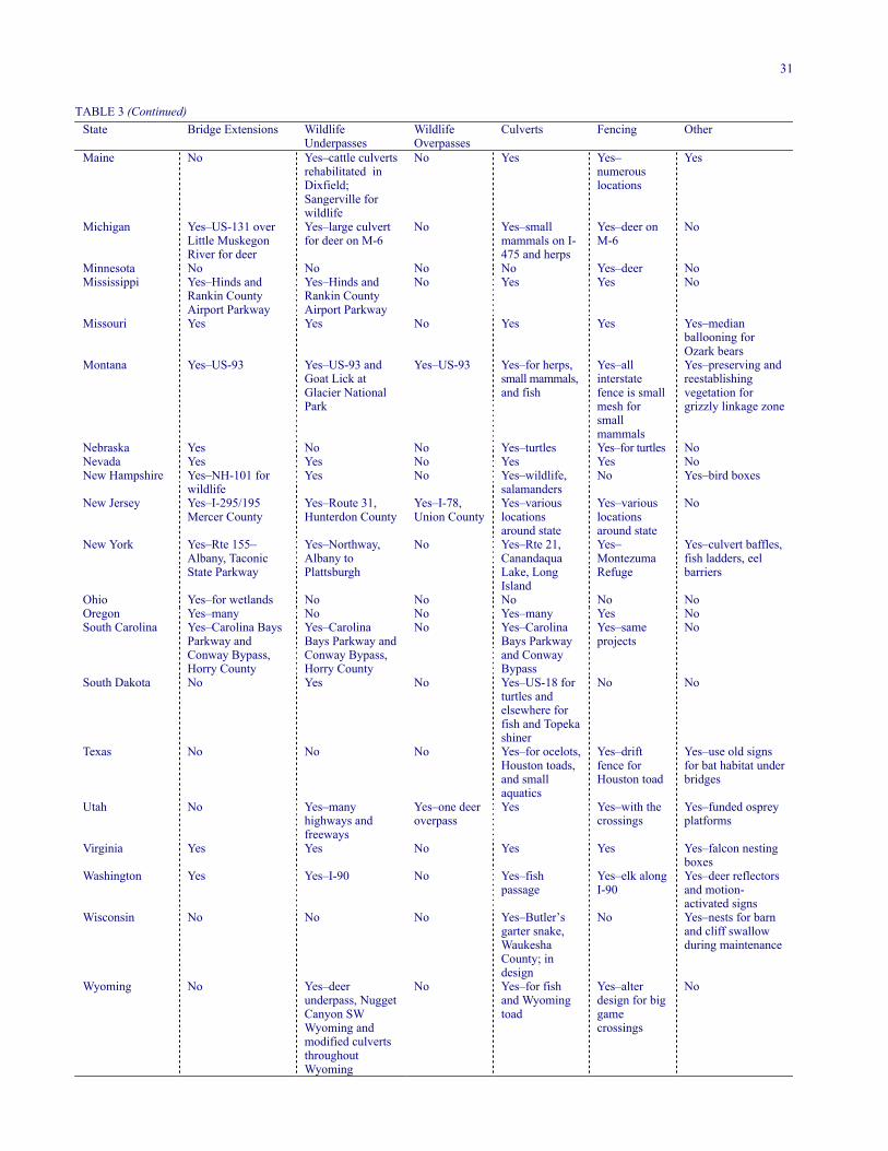
31
TABLE 3 (Continued)State Bridge Extensions Wildlife
UnderpassesWildlifeOverpasses
Culverts Fencing Other
Maine No Yes–cattle culvertsrehabilitated inDixfield;Sangerville forwildlife
No Yes Yes–numerouslocations
Yes
Michigan Yes–US-131 overLittle MuskegonRiver for deer
Yes–large culvertfor deer on M-6
No Yes–smallmammals on I-475 and herps
Yes–deer onM-6
No
Minnesota No No No No Yes–deer NoMississippi Yes–Hinds and
Rankin CountyAirport Parkway
Yes–Hinds andRankin CountyAirport Parkway
No Yes Yes No
Missouri Yes Yes No Yes Yes Yes–medianballooning forOzark bears
Montana Yes–US-93 Yes–US-93 andGoat Lick atGlacier NationalPark
Yes–US-93 Yes–for herps,small mammals,and fish
Yes–allinterstatefence is smallmesh forsmallmammals
Yes–preserving andreestablishingvegetation forgrizzly linkage zone
Nebraska Yes No No Yes–turtles Yes–for turtles NoNevada Yes Yes No Yes Yes NoNew Hampshire Yes–NH-101 for
wildlifeYes No Yes–wildlife,
salamandersNo Yes–bird boxes
New Jersey Yes–I-295/195Mercer County
Yes–Route 31,Hunterdon County
Yes–I-78,Union County
Yes–variouslocationsaround state
Yes–variouslocationsaround state
No
New York Yes–Rte 155–Albany, TaconicState Parkway
Yes–Northway,Albany toPlattsburgh
No Yes–Rte 21,CanandaquaLake, LongIsland
Yes–MontezumaRefuge
Yes–culvert baffles,fish ladders, eelbarriers
Ohio Yes–for wetlands No No No No NoOregon Yes–many No No Yes–many Yes NoSouth Carolina Yes–Carolina Bays
Parkway andConway Bypass,Horry County
Yes–CarolinaBays Parkway andConway Bypass,Horry County
No Yes–CarolinaBays Parkwayand ConwayBypass
Yes–sameprojects
No
South Dakota No Yes No Yes–US-18 forturtles andelsewhere forfish and Topekashiner
No No
Texas No No No Yes–for ocelots,Houston toads,and smallaquatics
Yes–driftfence forHouston toad
Yes–use old signsfor bat habitat underbridges
Utah No Yes–manyhighways andfreeways
Yes–one deeroverpass
Yes Yes–with thecrossings
Yes–funded ospreyplatforms
Virginia Yes Yes No Yes Yes Yes–falcon nestingboxes
Washington Yes Yes–I-90 No Yes–fishpassage
Yes–elk alongI-90
Yes–deer reflectorsand motion-activated signs
Wisconsin No No No Yes–Butler’sgarter snake,WaukeshaCounty; indesign
No Yes–nests for barnand cliff swallowduring maintenance
Wyoming No Yes–deerunderpass, NuggetCanyon SWWyoming andmodified culvertsthroughoutWyoming
No Yes–for fishand Wyomingtoad
Yes–alterdesign for biggamecrossings
No

32
FIGURE 1 Fine mesh fence and culvert for small mammals inEurope.
from 2 × 2 cm (0.78 in.) to 4 × 4 cm (1.57 in.) buried 20 to40 cm (7.87–15.75 in.) with a height extending from theground of from 0.5 to 1 m (1.64–3.28 ft). Specific applica-tion of this type of fencing depends on the target species.For reptiles and amphibians, the upper edge of the finermesh is bent over at a 90-degree angle to provide a lip toprevent animals from climbing over the fence. In WatertonPark, Canada, a temporary silt barrier type fence is used todirect frogs into polyvinyl chloride (PVC) drop traps sothat volunteers can move them across the highway to apond during the few-week-long migration period. Europe-ans use a PVC barrier (Figure 2) with an angled lip to keepreptiles and amphibians off the highways. Another appli-cation for reptiles and amphibians in Europe is a fabricatedgalvanized steel rail with a barrier lip along the upper edge(Figure 3).
FIGURE 2 Plastic barrier with angled lip used for reptiles andamphibians in Europe.
California used a unique fencing application for deserttortoise approximately 6 km (3.7 mi) east of Kramer Junc-tion on Highway 58 in San Bernardino County. A finer[1.27 cm (0.5 in.)] mesh section of wire fence, approxi-mately 50.8 cm (20 in.) in height, was installed along thebottom of a typical 1.22-m (4-ft) right-of-way fence. Thefiner mesh fence was buried approximately 15 cm (5.9 in.)to prevent animals from going under. This portion of thefence was held in place using three strands of wire. The
fencing application was done on an approximately 35.42-km (22-mi) section of four-lane highway. The fencing an-gled into the road at a series of culverts and bridges thatwere constructed for wildlife connectivity (Figure 4).
FIGURE 3 Galvanized steel barrier with lip used for reptilesand amphibians in Europe.
FIGURE 4 Tortoise fencing along Highway 58 in California forDesert Tortoise.
Another factor associated with fencing is the aspect ofwildlife being trapped between the fences should they finda way to enter the rights-of-way under, over, or around thefence ends. Because fencing is not totally exclusionary,Bissonette and Hammer (2000) studied two highway sitesin Utah to compare the use of one-way gates and earthenramps. They found that earthen ramps were used from 8 to11 times more than one-way gates.
Another fencing application that may prove useful insite-specific applications is the ElectoBrad fence (electricfence) that was researched for deer exclusion in test plotsin Michigan (Rogers et al. 1999).
Fencing is also being used for a variety of other animalsfrom turtles and the Houston toad to black bear and grizzlybears (Table 3). Irrespective of the species, fencing withoutprovisions for movement across the road can cause disrup-tion of connectivity resulting in isolation of populations.This can be especially problematic for species with lowpopulations, where the possibility of extinction can result(Shaffer and Samson 1985).

33
As mentioned previously, the problem associated withfencing is that it is a barrier to wildlife movement such thatwhen used over large stretches of highway, connectivityfor wildlife movement across highways needs to be pro-vided. The following are some of the methods that are be-ing used to provide connectivity.
Modified Drainage Culverts
The Netherlands is a leader in modifying extant drain-age culverts to accommodate wildlife (Bekker 1998).Animals are able to move through the culverts onshelves and floating docks or through wildlife tunnelsbuilt parallel to the wet culvert. These structures areproving effective for small mammals and amphibians(Veenbass and Brandjies 1997). Montana is successfullyusing similar designs on US-93 south of Lolo for smallmammals (Foresman 2002).
Modified culverts were tried on US-98 in Texas forocelots and bobcats (Hewitt et al. 1998). Existing cul-verts were modified with a 0.46 m wide × 0.30 m high(18 in. × 12 in.) elevated concrete walkway to allowanimals to move through even when water was present.However, ocelots were not shown to use the culverts.This was largely attributed to the low population in thearea. More recently, Tewes and Hughes (2002) studiedthe ocelots along transportation corridors in southernTexas by looking at roadkill and habitat features to helpdetermine locations for future crossings and developmanagement strategies.
Other applications of modified culverts include Califor-nia reporting success in decreasing beavers blocking cul-verts with debris by having a central “sacrificial” culvertwith other culverts placed on both sides but at a higher ele-vation for drainage and connectivity. The beavers attemptto block the lower culvert, and the adjacent culverts athigher elevation remain open. Beaver-exclusion devices,including fencing, perforated pipe, or a combination of thetwo have been successfully used throughout the UnitedStates to reduce impounding of water behind road fills andfor wetland mitigation and habitat preservation. For an ex-ample go to: http://fund.org/library/documentviewer. asp?ID =81&table=documents or http://www.dnr.state.wi.us/org/water/fhp/waterway/beaver.PDF
Drainage Culverts
Table 3 reports that a number of states are using culverts indifferent applications for a variety of species. Florida,Montana, New Hampshire, Texas, and Wisconsin are usingculverts for reptiles and amphibians. Nebraska and SouthDakota are using them for turtles.
These dual-purpose culverts are proving successful inaccommodating both terrestrial and aquatic organismsdepending on water levels in the area of the culverts. Whenplaced at the proper elevation, they can serve both types oforganisms. They are typically used where highway cause-ways or fill sections transverse wetlands with fluctuatingwater levels such as wet prairies and marsh. They are alsoused on intermittent streams and floodplain areas that mayinundate during wet periods. Aquatic species such am-phibians and fish use them when they are wet and terres-trial species including reptiles and small mammals usethem when they are dry. If sized properly, everything fromsmall aquatic organisms to larger mammals such as deerand bear will use them.
This sort of application is proving successful for a widerange of terrestrial and aquatic species on Payne’s Prairie,a wet prairie near Gainesville, Florida. A 1.1-m (3.5-ft)concrete wall with a 15.2-cm (6-in.) lip at the top keepsreptiles and amphibians from getting onto the highway fornearly a 3.22-km (2-mi) stretch of US-441 in central Flor-ida. A series of wet/dry culverts allows wildlife to movesafely under the highway. Sand track stations, live traps,and infrared cameras have been used to monitor the widevariety of animals, from reptiles and amphibians to smallmammals using the culverts (USGS 1999).
A modification resulted in the establishment of two am-phibian tunnels approximately 61 m (200 ft) apart on HenryStreet in Amherst, Massachusetts, that were researched byJackson and Tyning (1989) and Jackson (1996).
The Dutch are using concrete pipes, metal pipes, orrectangular concrete tunnels approximately 0.4 to 2.0 m(1.31–6.56 ft) in diameter in conjunction with fine meshfencing for reptiles and amphibians as well as other smallmammals (Wildlife Ecology . . . 2002).
Pictures of the Payne’s Prairie wall, Massachusetts am-phibian tunnels, Dutch structures, and wildlife using theculverts mentioned above, as well as other projects around theworld can be seen at http://www.fhwa.dot.gov/environment/wildlifecrossings. However, few states report formally re-searching the success of these structures.
Stream Culverts and Bridges
Like drainage culverts in upland areas, oversized culvertscan be designed and placed at the proper elevation overwaterways to provide passage for a large number ofaquatic and terrestrial species. The use of the naturalstream bottom rather than a concrete or metal bottom isbest. By providing shallow water or even dry edges alongthe stream edge in the culvert or bridge, the greatest num-ber of species can move through the these structures.

34
Given sufficient height, these culverts can even allowlarger mammals, such as deer, bear, and other species thatordinarily follow riparian corridors for movement, to passsafely under roads. A wide variety of designs are possibledepending on the site-specific construction environment—concrete box culverts, and round, oval, and elliptical pipeculverts. By providing substrate and cover on the inside ofthe culvert, similar to that of the exposed stream, the utilityof the culvert for a larger group of species can be im-proved. Proper sizing of the culvert depends on site-specific considerations and hydraulics, but including thenatural streambed and as much adjacent upland as possibleproves most successful.
A number of states report using specialized culverts andbridges in streams for uninterrupted or improved fish pas-sage (Table 3). In Washington, there are 4,463 sites wherestate highways cross fish-bearing streams. Of these loca-tions, more than 500 “problem sites” were identified.These were sites where the drop of the culvert’s outfallwas too high, exiting water velocities were too great, orwater depth was too shallow for adequate upstream fishpassage. The state transportation agency is fixing theseculverts using a “Priority Index System,” which considerspotential habitat improvements. These efforts have beendocumented by Carey and Wagner (1996).
Oregon has a similar program to retrofit culverts to in-crease the value and accessibility of upstream habitat. Theresource and sensitive areas for Oregon’s salmon are beingmapped (Carson et al. 2002). Chase (1998) describes theOregon regional approach to recovery as provided for inthe Oregon DOT.
Planning efforts, best management practices, and miti-gation for transportation projects in the Pacific Northwestwere examined by Corkran and Findley (2002). Theylooked at several projects in Oregon and Washington anddescribe fisheries issues, approaches used, and lessonslearned from these projects.
Stream restoration is also becoming a part of transpor-tation projects. Harman and Jennings (2002) describe res-toration projects in North Carolina that used the naturalchannel in the design technique. The projects were to im-prove water quality and habitat, reduce stream bank ero-sion, and enhance floodplain functions. Enhancements tostreams were provided during Maine Turnpike constructionfor two high-quality trout stream crossings to improve pro-ductive habitat and the carrying capacity of the streams.Log flow deflectors were provided to increase the depthand velocity of the main channel, create pools, scour finesediments, and divert water flow from eroding banks.Submerged woody debris and boulders were placed to pro-vide additional habitat. Log bank undercut structures were
provided to stabilize stream banks (Farrell and Simmons2002).
Fish passage structures in urban streams are also be-coming better understood. Hegberg et al. (2002A and B)presented approaches to hydrologic and resource issues aswell as hydraulic design and analysis. Recommendationsfor evaluation of target fish species characteristics, site-specific base flow hydrology, and hydraulics of structuresare provided. They also present a list of procedures for de-sign of passages.
To address the specifics of culvert design and placementthe Pacific Northwest National Laboratory in the state ofWashington has begun culvert testing for juvenile salmonidpassage (Pearson et al. 2002). Full-scale models will beused to look at hydraulic conditions (velocity, turbulence,and water depth) associated with various culvert designsunder various slopes and flow regimes.
States are also considering freshwater mussels in theconstruction of bridges and culverts. Savidge (1998) de-scribes erosion control measures, elimination of directdrainage from bridges, and structural features on severalprojects in North Carolina that were the result of protectedmussel species. Reutter and Patrick (2002) report on meas-ures taken for mussels in a bridge replacement on the Alle-gheny River 80.5 km (50 mi) north of Pittsburgh, Pennsyl-vania. The assessment included a construction/demolitionoptions evaluation, hydraulic and hydrologic analyses, andthe development and implementation of a mussel reloca-tion program with subsequent monitoring of success.
Wildlife Underpass Bridges and Dry Culverts
Many states are also using culverts of varying size in up-lands areas for a wide variety of wildlife species fromsmall mammals to ungulates (Table 3). Upland culverts areone of the most frequently used structures for wildlifecrossings and have proven successful for accommodating awide variety of species. Both pipe culverts and box cul-verts are proving effective—mainly for small animals.California is using culverts for San Joaquin kit fox. Illinois,Kansas, Montana, New Hampshire, New Jersey, Oregon,Texas, Utah, and Virginia are using culverts for other smallmammals. Arkansas, Colorado, Wyoming, Utah, Michigan,Maine, Washington, and Kansas report using larger cul-verts for deer and other wildlife. Small culvert sizes suchas 1.22 m × 1.22 m (4 ft × 4 ft) in Arkansas and 2.13 m ×2.44 m (7 ft × 8 ft) to 2.44 m × 3.66 m (8 ft × 12 ft) inColorado indicate that the states believe they can have suc-cess with these sizes. Again, there is a lack of formal re-search as the states experiment with these designs. Culvertsizes as small as 1.22 m x 1.22 m (4 ft × 4 ft) in Arkansas

35
FIGURE 5 Box culvert being used by wildlife in Banff NationalPark.
FIGURE 6 Infrared camera set-up in Banff National Park to monitor use of structures.
up to 2.44 m × 7.32 m (8 ft × 24 ft) in Florida were re-ported in the survey of the states
An extensive research project addressing the use of drydrainage culverts was conducted by Clevenger and Waltho(2000). Banff National Park had used a variety of culvertsizes for small and medium-sized mammals (Figure 5).These researchers used infrared triggered cameras (Figure6), track beds, and snow tracking to research 24 of thesestructures during the winter of 1999. They found that pas-sage was positively correlated with traffic density, roadwidth, road clearance, and culvert length. They also found
that all species with the exception of coyotes and shrewspreferred small culverts with low openness ratios. Thereappeared to be some evidence of predation at crossings sothe thought was that the smaller culverts provided comfortto the prey species. Weasels and shrews preferred culvertswith nearby cover. The researchers felt that drainage cul-verts could be used to mitigate the harmful effects of high-speed roads and recommended frequently placed culverts[150–300 m (492.13–984.25 ft)] of varying size be placedin close proximity to shrub or tree cover.
Boarman and Sazaki (1996) reported that desert tortoiseand other vertebrates in California’s western Mojave Des-ert are using culverts of varying construction and size(Figure 7). In 1990, the California Department of Trans-portation (Caltrans) erected tortoise-barrier fencing alongboth sides of Highway 58 from a point approximately 6 km(3.72 mi) east of Kramer Junction. The fence consists of60-cm (23.62-in.) wide, 1.3-cm (0.51-in.) mesh hardwarecloth buried to 15 cm (5.9 in.) beneath ground level thatextends 45 cm (17.71 in.) above the ground (Boarman etal. 1997). The fence angles into culverts and bridgesspaced approximately every kilometer along the route. Theculverts are made of 0.9 to 1.5 m (2.95–4.92 ft) corrugatedsteel pipe; 1.4 m (4.59 ft) diameter reinforced concretepipe, or 3 to 3.6 m (9.84–11.8 ft) by 1.8 to 3 m (5.90–9.84ft) reinforced concrete boxes. The culverts were 33 to 66 m(108.27–216.54 ft) in length. Figures 7 and 8 show pipeand box culverts used on Highway 58. Three bridges (Fig-ure 9) that cross natural washes were also fenced to pro-vide connectivity. With a four-laning project on Highway58, there are now approximately 26 crossing opportunitiesfor wildlife, which range from approximately 1 m (3.28 ft)ribbed pipe culverts to 61 m (200 ft) bridges that are ap-proximately 2 m (6.56 ft) high in the 35.42 km (22 mi)project.
FIGURE 7 Box culvert used by desert tortoise along Highway58 in California.
Culverts varying in size from 1.5 to 10 m (4.92–32.81ft) in diameter were used successfully in New South Wales,Australia, for a large group of terrestrial mammals andreptiles (Norman et al. 1998).

36
FIGURE 8 Pipe culvert for desert tortoise on Highway 58 inCalifornia.
FIGURE 9 Bridge overdry wash used by wildlife on Highway58 in California.
FIGURE 10 Goat bridge underpass on Highway 2 near GlacierNational Park.
Wildlife underpasses are bridges and/or large culvertsover dry land and sometimes land and water, constructedexpressly to facilitate wildlife movement in important cor-ridor areas. The length and height of these large culverts orbridges varies with the wildlife expected to use them.
Twenty-three of the responding states reported usingunderpasses for wildlife (Table 3). Some species being ad-dressed in the responses included bobcat and coyote in SanBernardino, California; deer in most states; and goats atGlacier National Park, Montana (Figure 9). Singer andDoherty (1985) studied the use of the two structures inGlacier National Park: Goat Bridge [8 m (26.24 ft) high ×23 m (75.46 ft) wide × 11 m (35.80 ft) long] and SnowslideGulch Bridge [3 m high × 3 m wide (9.84 ft × 9.84 ft) × 11
m (35.80 ft) long]. Figure 10 shows the Goat Bridge andFigure 11 shows the Snowslide Gulch Bridge. They foundthat goats were crossing and making it safely to the min-eral lick located on the Flathead River.
FIGURE 11 Snowslide gulch bridge for goats on Highway 2near Glacier National Park, Montana (three views).
Significant provisions were made for wildlife on High-way 241, a toll road in southern California. Wildlife under-pass bridges (Figure 12) that varied in length, bridge ex-tensions, and viaducts (Figure 13) over rivers and drystreambeds were used to provide connectivity to the adja-cent private, federal, and state lands. The bridges, severalhundred feet long, traverse topographic features that allowfor both wildlife and occasional human access for utilitymaintenance. Unfortunately, land-use planning has allowedfor development in several areas along the corridor therebycompromising the integrity of adjacent wildlife habitat(Figure 14).

37
FIGURE 12 Wildlife underpass on Highway 241 in southernCalifornia.
FIGURE 13 Viaduct on Highway 241 in southern California.
FIGURE 14 California structures suitable for wildlife use butprecluded by adjacent development.
On Highway 71 in southern California, large pipe cul-verts (Figure 15) were used as wildlife underpasses to pro-vide wildlife connectivity to habitat in the Prado FloodControl Basin. The successful use of these structures bywildlife led Caltrans to include bridge spans in lieu of cul-verts in planned upgrades for the facility.
Wildlife underpasses of varying designs were used inBanff National Park in Canada. The underpasses variedfrom 25.6 to 67.5 m (83.99–221.46 ft) in length, 4.2 to13.4 m (13.78–43.96 ft) in width, and 2.5 to 4.0 m (8.20–13.12 ft) in height (Figure 16). These underpasses havebeen used successfully for a variety of animals, includingelk, deer, coyote, wolf, black bear, grizzly bear, and cougar(Clevenger 1998; Clevenger and Waltho 1999, 2000). A
more detailed discussion of the crossings used in Banff canbe found in the case study in chapter 10.
FIGURE 15 Large pipe culvert being used by wildlife underHighway 71 in southern California.
FIGURE 16 Large pipe culvert being used by a variety ofwildlife in Banff National Park, Alberta.
FIGURE 17 Pre-cast segment construction of box culvertwildlife underpass in Florida.
Florida used 2.44-m (8-ft) high and 7.32-m (24-ft) widebox culverts for a variety of species in central and southFlorida. Depending on the remoteness of the area of use,these concrete box culverts can be cast in place or pre-cast(Figure 17) for shipment to the site. Fencing associatedwith these crossings was 3.04 m (10 ft) in height with threestrands of barbed wire on an outrigger. A wide variety of

38
species use the culverts, including the Florida panther andblack bear (Land and Lotz 1996; Roof and Wooding 1996).
Florida has also used 36.58 m (120 ft) bridges with a2.44 m (8 ft) height in the Big Cypress Preserve area formovement of wildlife under I-75. The crossings have beenused by a wide variety of wildlife including the Floridapanther and black bear (Foster and Humphery 1995; Evink1996; Land and Lotz 1996). A more detailed discussion ofFlorida wildlife crossings is contained in the case study inchapter 10.
New Jersey built a structure of similar size under Route31 near Clinton that is approximately 2.44 m (8 ft) highand 6.08 m (20 ft) wide and 36.28 m (119 ft) long. It is acombination crossing that is also used by pedestrians in apark. The structure was built using 25 pre-cast, post-tensioned, elements.
Early research on the use of culverts was mainly for un-gulates and indicated some success with small box culvertsfor certain species. Mule deer seem to be more reluctant touse small box culverts than their white-tailed cousins(Reed et al. 1975; Ford 1980; Ward 1982). However, afteran acclimation period, they are using them.
Wyoming is conducting research on a wildlife crossingon US-30 through Nugget Canyon between Kemmerer andCokeville. The crossing is the result of the Nugget CanyonWildlife Migration Project Act passed by the WyomingState Legislature to mitigate deer/vehicle collisions in thearea. A concrete box underpass with dimensions 6.08 m(20 ft) wide, 9.12 m (30 ft) long, and approximately 3.35 m(11 ft) high was constructed after other measures men-tioned in the Non-Structural Section of this report hadfailed. Wildlife movement was monitored using an infraredvideo system with two lenses mounted at each end of thecrossing. Light-emitting diode (LED) lights were used toimprove image quality. Two sets of infrared scope acti-vated the system that recorded to a VCR. A TrailmasterTM 1500 infrared sensor recorded the time and date ofanimal use. Approximately 2,000 animals (elk, mule deer,and antelope) have used the crossing. The plan is to modifythe dimensions of the crossing in the spring of 2002 to de-termine the dimensions needed for mule deer use for futurecrossing designs. Other locations have been identified thatmay warrant wildlife crossings in the future (Gordon2002B).
Phillips et al. (2002) studied the use of an underpass onI-70 at Mud Springs Gulch near Vail, Colorado. The boxculvert structure constructed in 1970 is 3.05 m (10 ft) high,3.05 m (10 ft) wide, and 30.5 m (100 ft) long. Subse-quently, a pedestrian/cyclist path was constructed adjacentto I-70 with an elevated bridge in the area of the underpass.The researchers found that highway traffic and the presence
of humans at the crossing disturbed the deer attempting touse the crossing. A temporary screen that was installed toblock the view of human presence helped reduce distur-bance to the deer. The result was a recommendation for apermanent screen. The research also indicates that muledeer will use a crossing of this small size.
Austin and Garland (2002) researched wildlife use of adouble box culvert on Vermont State Highway 289 in Es-sex. The crossing has one box for a small stream and an-other box with higher bottom elevation for wildlife move-ment. Each box is 3.05 m wide (10 ft), 3.96 m high (13 ft),and 97.54 m long (320 ft). There is a 1.22 m (4 ft) fencealong the highway in the area of the underpass. The under-pass was monitored using Trailmaster 550 passive infraredmonitors with Trailmaster TM35-1, a 35mm camera, andtrack plots. Raccoon, mink, weasel, and skunk were foundto be using the structure; however, deer that were in thearea did not.
North Carolina is constructing three underpasses forblack bears at a new location, US-64 near the Outer Banksin Washington County. The dimensions will be approxi-mately 38 m (124.64 ft) wide, 2.4 to 3.0 m (8–10 ft) high,and approximately 100 m (328 ft) long. The locations ofthe underpasses were determined by studies conducted bythe North Carolina Wildlife Resources Commission in1999. They used track counts, ditch crossings, and infraredcameras to determine locations (Scheick and Jones 1999).To estimate population density and determine genetic re-latedness, the University of Tennessee has been collectingpre-construction information with radio-collared bears andanalyzing DNA samples from hair collected at 140 barbed-wire hair traps. They also used infrared cameras to meas-ure activity in the areas near planned crossings. The pre-construction study was completed in June 2001 and post-construction study will start after completion of the high-way in 2004 (van Manen et al. 2002).
Extended Bridges and Existing Structures
One of the most successful and cost-effective means ofproviding for wildlife movement down riparian corridors isthe extended bridge. Twenty-four of the responding statesreported using extended bridges for wildlife movement andwetland protection (Table 3). Providing adequate area forboth water movement with associated organisms and dryhabitat for terrestrial species movement has proven suc-cessful. Again, the characteristics of the area need to beconsidered when trying to determine the appropriate lengthof the bridge. In cases where there is an important corridorfor movement of rare or protected wildlife species, bridg-ing the entire floodplain may be necessary. At the otherend of the spectrum, where the floodplain is being used byhabitat-limited species, a combination of smaller structures

39
and fences may be possible. An important considerationwhen choosing a combination of bridge and fill is whatreptile and amphibian species will likely move up the fillslope on to the road. Standard fencing will not stop thismovement so that very expensive barrier walls and associ-ated guard rails may be necessary to prevent significantkills of these species during periods of the year when theyare moving around in large groups. Another considerationis the cost of mitigation for wetland takings by opting for afill section. By the time the costs of shorter bridges or cul-verts, fill acquisition, barrier walls for reptiles and am-phibians, guardrails, and fencing are factored in, alongwith the cost of wetland mitigation, the cost of a more sub-stantial bridge, preferred for habitat connectivity, may al-ready have been approached.
Singleton and Lehmkuhl (1999) researched existingbridges and culverts along 48.30 km (30 mi) of highwayfrom Snoqualmie Pass to the town of Cle Elum in Wash-ington. They mapped 58 culverts and 31 bridges and un-derpasses along the I-90 study area. Thirty structures (24culverts and 6 bridges) were monitored using automaticcameras, track plates, and tracking beds. They found thatreptiles, amphibians, and small mammals were using thestructures.
Haas and Lyren (2000) monitored existing structures onHighway 71 between Euclid Avenue and Highway 91 eastof Los Angeles, California, with remotely triggered cam-eras and track/scat surveys. They also radio collared 4bobcats and 53 coyotes to monitor movement. They con-cluded that, although small mammals were using some ex-isting structures, larger underpasses were needed for muledeer. They made further recommendations on some spe-cific sites for underpass improvements.
Viaducts
Viaducts are a potential solution for the entire spectrum ofspecies moving through an area. Long bridges such asthose found over wetlands, rivers, and variable topographyand geology are viaducts. Typically, this approach is mostcost-effective where there is topographic relief sufficient tomake bridging necessary for a significant span of a water-way, canyon, or valley. As a result most viaducts are lo-cated in mountainous areas. They are very effective be-cause wildlife naturally use spanned lands for movement.Most existing viaducts were constructed because it was thebest or most esthetic way to cross a valley or ravine froman engineering standpoint rather than to accommodatewildlife. However, their consideration and design for wild-life is increasing, especially in Europe.
Figure 18 shows one of three viaducts [593 m (1945.04ft), 160 m (524.8 ft), and 265 m (869.20 ft in length] used
in Slovenia on the Ljubljana–Trieste highway. This viaductis being successfully used by brown bear, wolf, and anumber of ungulates (Kobler and Adamic 1999).
FIGURE 18 Viaduct on the Ljubljana–Trieste Highway inSlovenia.
FIGURE 19 Viaduct on Highway 241 in southern California.
None of the states responding to the questionnaire re-ported using this concept for wildlife connectivity. Al-though there are numerous viaducts in the United Statesand Europe, wildlife movement was not the primary mo-tive in their development. However, wildlife connectivitycould be one of multiple considerations resulting in a via-duct. Several viaduct-length bridges traverse rivers andfloodplains on the Highway 241 toll road in southern Cali-fornia (Figure 19). The curves of the picturesque LinnCove viaduct on the Blue Ridge Parkway in North Carolinahug the winding contours of the underlying mountain. Thisproject was completed in 1983 at a cost of almost $10 million,with multiple environmental considerations in mind. Regard-less of the ultimate reasons for design, viaducts can help pro-vide important corridors for wildlife movement.
Wildlife Overpasses
Although wildlife overpasses are largely a European phe-nomenon (Berris 1997; Keller and Pfister 1997), there are

40
now a few U.S. structures. Florida, Hawaii, New Jersey,and Utah reported overpasses being used by wildlife.
The New Jersey overpasses, among the first in theUnited States, were completed in 1985 at a cost of $12million. The two overpasses were designed to provide con-nectivity across I-78 (a six-lane highway) at an approxi-mately 2-mile stretch that crossed the Watchung Reserva-tion in Union County. Figure 20 shows one of thevegetated overpasses [91.46 m (300 ft) wide]. The other[61 m (200 ft) wide] has pavement as well as vegetation.At the time of construction, the deer herd in the WatchungReservation was small and there was great concern aboutmortality on the highway. Although no formal research hasbeen conducted, deer have been observed using the cross-ings and the health of the local population indicates thesuccess of the overpasses. Currently, the deer population ison the increase; however, local development has en-croached on the reservation such that the deer are consid-ered a nuisance by local landowners.
The Utah overpass was constructed principally for deer.The Florida overpass on I-75 in Marion County just northof County Road 484 is a multi-use overpass designed toaccommodate a recreational and equestrian trail, as well asfor wildlife use [see the Florida case study (chapter 10) forfurther details].
Two overpasses were built over the Trans-CanadaHighway in Banff National Park and are being used by avariety of wildlife (see the case study, chapter 10).
I-78 large cover view from roadway
Both covers viewed from I-78
FIGURE 20 Overpass being used by deer and other wildlife inNew Jersey.
Montana (US-93) and Connecticut (Route 6) are cur-rently planning wildlife overpasses (Table 3).
Wildlife overpasses are used extensively in Europe andvary in width from 3.4 m (11.15 ft) to 870 m (2,853.6 ft).Pfister et al. (1997) conducted research on five wildlifeoverpasses on the Stockach–Uberlingen section of Germanhighway B31 (Figure 21) and looked at 12 other over-passes in Germany, The Netherlands, France, and Switzer-land. They also did a follow-up study looking at otheroverpasses (Pfister et al. 1999) using the same infraredvideo camera technology. The research looked at largemammals, small mammals, and flightless insects, such asground beetles, grasshoppers, ground spiders, and diurnalbutterflies. When there is suitable habitat at and leading tothe overpasses, it was found that the overpasses were ef-fective for a wide variety of animals including inverte-brates. The conclusions included the observation thatstructures at least 60 m (196.8 ft) wide were more effectivethan overpasses narrower than 50 m (164 ft), especially forlarger mammals. It was noted that animal behavior on theoverpasses was more normal on the wider structures.
FIGURE 21 Vegetated overpass in Europe approximately 50m wide.
Other Structural and Non-Structural Measures for Wildlife
Signage is a common approach to informing motoristswhen they are entering an area where the danger of wild-life collision is high. Romin and Bissonete (1996) reportthat most states have tried deer warning signs, hazing, re-duced speed limits, and public awareness campaigns, butfew states have conducted research to determine the effec-tiveness of these techniques.
The Swiss have used a series of solar-powered, battery-operated, motion sensors to determine animal presence thattrigger low-voltage, LED-illuminated warning signs thatreduce the posted speed limit to 40 km/h and alert motor-ists to the presence of approaching wildlife (Figure 22).The installation of these measures was very successful inreducing deer mortality on the referenced country road.The location on the road was also adjacent to a large wild-life overpass over a major nearby freeway.

41
FIGURE 22 Swiss warning sign that illuminates when animals are present near the
highway.
Utah and Georgia examined warning devices (whistles)on cars, but these did not prove effective (Romin andDalton 1992). Europeans have also found ultrasound androad lighting to be ineffective in reducing wildlife mortal-ity (Wildlife Ecology . . . 2002). Utah tried interceptionfeeding, placing food plots in areas away from the high-way. These proved effective only during the portions of theyear when mule deer were concentrated (Wood and Wolfe1988).
Deer reflectors have been tried in many different areasof the world. Pafco and Kovach (1996) reported dramaticreductions in deer/vehicle accidents in the rural coniferousforest, central hardwoods, and farmland habitats in ruralMinnesota. However, two other sites with steep slopeswere apparent failures. A California study on SR-36 east ofChester resulted in no statistical difference in the mean ofdeer killed whether or not the reflectors were in operation(Ford and Villa 1993). Molenaar and Henkens (1998)completed a literature review of research conducted on re-flectors and determined that there was no conclusive evi-dence that the reflectors worked. However, additional re-search may be needed on this approach.
As part of an effort to reduce deer collisions, Wyomingtried traditional deer signing, an infrared sensing devicethat activates a flashing light system to warn motorists ofdeer presence, and reflectors in the area of a gap in 11.27km (7 mi) of 2.43-m (8-ft) high deer fence on US-30 inNugget Canyon. None of the measures was found effectiveand this caused the Wyoming DOT to move on to thestructural alternative that is reported in the Wildlife Under-pass Section of this report (Gordon et al. 2001; Gordon2002A).
Florida reported installing PVC pipe approximately 3 m(9.84 ft) in height perpendicular to the railing on the SanSebastian Bridge to keep bird flight patterns above the ele-vation of traffic. The poles were spaced approximately 3.7m (12 ft). The rationale was to keep those birds hoveringover the bridge from dropping down into traffic crossingthe bridge. The technique has been found to reduce birdkills on the bridge (Egensteiner et al. 1998).
HABITAT TECHNIQUES
Twenty-six states indicated that they use habitat restorationor preservation as mitigation for impacts to habitat orwildlife other than wetland impacts. One of the larger proj-ects is Colorado’s shortgrass prairie effort, described in theprogrammatic agreement discussions earlier in this chapter.Florida has approximately 688 hectares (1,700 acres) ofupland mitigation bank, which is used to offset project im-pacts for 27 state and federally listed species in a 13-county service area. The FHWA reimburses the FloridaDOT when credits are used for specific transportationprojects. A trust fund was established with the Florida Fishand Wildlife Conservation Commission for perpetual man-agement and maintenance of the habitat for listed species.Improvements that result in higher listed species popula-tions result in increasing available credit. An inventory istaken every 5 years to document population status.
California, in partnership with a group of public andprivate organizations, purchased habitat in the Coal Can-yon area of Puente–Chino Hills to provide a corridor ofhabitat to help implement a Natural Communities Conser-vation Planning effort that includes important natural areassuch as the Cleveland National Forest, Tecate Cypress Pre-serve, Camp Pendleton, Santa Rosa Plateau, Santa Marga-rita River, Starr Ranch, Irvine Company Reserves, ChinoHills State Park, Prado Basin, Tonner Canyon, SchabarumRegional Park, and Powder Canyon. These are some of thelast remaining natural areas in southern California. Thecorridor is constricted in the area of the Riverside Freeway(SR-91) such that Caltrans participated in an outright habi-tat purchase and plans to decommission the Coal Canyoninterchange and use the existing interchange bridge as awildlife underpass. Plans include fencing to guide wildlifeto the bridge and removal of pavement to provide a corri-dor under the interchange bridge. This project demon-strates a significant commitment of resources for environ-mental enhancement.
The following are some other state habitat mitigationactivities:
• Georgia has purchased habitat for wood stork forag-ing and gopher tortoise/indigo snake mitigation.
• Iowa has purchased prairie and woodland habitats.

42
• Kentucky has purchased habitat for endangeredplants.
• Kansas has planted trees and native grasses and un-dertaken stream meander and riffles restoration.
• In Maine, preservation and restoration are emergingas the major options for reducing habitat impacts.
• Minnesota has done prairie and native grass restora-tion.
• Montana uses stream and riparian corridor restorationfor listed species conservation measures.
• Nebraska has used conservation easements to protectwhooping crane roosting habitat.
• New Hampshire has preserved habitat tracts in im-portant wildlife corridors.
• Ohio has done preservation or restoration to a limiteddegree, but not commonly.
• Oregon has undertaken stream bank restoration.• Texas has used conservation easements and one-fee
simple purchase with management plans for endan-gered plants.
• Utah uses county Habitat Conservation Plans forfunding habitat for desert tortoise and Utah prairiedogs.
• Washington uses habitat mitigation to a limited de-gree where part of an overall package of mitigation,but not typically for listed species. The state has alsofunded research and developed rare plant manage-ment plans.
• Wisconsin legislature has prohibited habitat acquistionas mitigation, but allows the DOT to place money inan existing stewardship program.
• Wyoming has provided land for big game habitatpreservation.
• Idaho has purchased winter range for deer and habitatfor plants.
Maintenance of these habitat mitigation efforts is discussedin chapter 8.
PROGRAMMATIC AGREEMENTS
Programmatic agreements are a relatively new approach toresolving wildlife impacts. Reviewing impacts at the pro-gram level makes a lot of sense, because it speaks to theoverall impact of highways in a given area to specific envi-ronmental issues. The survey of states revealed that 22 hadentered into programmatic agreements principally forwetland mitigation. Programmatic agreements are also be-coming a part of state streamlining efforts.
Colorado’s Shortgrass Prairie Initiative
In April 2001, the Colorado DOT (CDOT) entered into aMemorandum of Agreement (MOA) with the FHWA,
FWS, the Colorado Department of Natural Resources(DNR), Colorado DNR Division of Wildlife (CDOW), andthe Nature Conservancy (TNC) “to effect regional conser-vation of declining species on Colorado’s Eastern Plainsby providing proactive advance conservation of priorityhabitats for multiple species and that will allow CDOT andFHWA to address compliance with the Endangered SpeciesAct for listed species and for declining species that maybecome listed.” The MOA was based on the CDOT 20-year plan for improvements on Colorado’s Eastern Plains.With the help of the Colorado Natural Heritage Programthe parties arrived at an estimate of the collective impactsto declining species from the proposed transportation proj-ects. A technical Conservation Site Identification Panelheaded by TNC and CDOW will evaluate and recommendareas of real property interest from willing sellers for large-scale conservation/mitigation that CDOT will present tothe FHWA and FWS for approval for purchase by CDOT.The FHWA will reimburse the state for mitigation creditsas they are used on future projects. The project aims topreserve approximately 6070.5 to 8094 hectares (15,000–20,000 acres) or more of shortgrass prairie habitat over thenext 2 years, protecting approximately 25 target species,including mountain plovers, black-tailed prairie dogs, bur-rowing owls, swift foxes, box turtles, ferruginous hawks,and numerous secondary species. In Colorado, only 40%of prairie land remains, and much of that is degraded fromfragmentation and overuse. The CDOW will “own andmanage the conservation areas in accordance with the pur-pose for which it was acquired.”
It is the purpose of the MOA to provide for conserva-tion of the important habitats in Colorado’s Eastern Plainswhile advancing the transportation goals contained in theCDOT 20-year plan. For CDOT, the MOA reduces mitiga-tion costs and Section 7 (ESA) consultation times andmakes project timelines more predictable.
Additionally, Colorado has entered into a programmaticagreement on the Canada lynx. A standard methodologyfor impact assessment and mitigation design was devel-oped. By following programmatic standards, CDOT willensure that the FWS evaluates projects on a consistent,predictable basis. A number of project types with lowprobability of involvement were excluded from lynx-specific mitigation measures (Barnum 1999).
Other State Initiatives
The following are programmatic activities of other states:
• Alaska is developing an agreement on fish passagecriteria and Essential Fish Habitat using agreementsfor species and sensitive areas where managementneeds coordination for species and habitat.

43
• Connecticut uses U.S. Army Corps of Engineers(USACE) Highway Methodology, but has found thatit does not work to resolve ecological issues.
• Georgia is working on guidance for the Clean WaterAct Section 404 permitting process and threatenedand endangered species.
• Kentucky has a wetland banking MOA and propertytransfer agreement for wetland mitigation property.
• Minnesota has a project streamlining agreement withother state agencies.
• Mississippi has a wetland banking agreement with theUSACE.
• Montana developed an agreement for a state and fed-eral interagency research technical committee and hasa MOA with the state universities related to researchand with state and federal agencies “ConcerningWildlife Connectivity and Highway Projects.”
• New Jersey has an agreement for wetland mitigationbanking.
• Oregon has a programmatic Biological Assessment for
culvert retrofit for fish passage; emergency maintenanceof mudslides, bridge replacement, and tree removal.
• Texas is working on an agreement for mitigation oflisted plants.
• Utah is working on a programmatic agreement for allprojects with little or no listed species involvement.
• Washington has a programmatic agreement in placefor the Olympic Region and is looking at statewideapplication for salmon.
• Wisconsin has an agreement with their DNR on howto resolve issues on how to handle transportation im-pacts. It covers many issues including endangeredspecies, erosion control, and stormwater runoff. Thestate also uses Habitat Conservation Plans in workingwith the FWS and their DNR.
• South Dakota established a wetland bank in 1988.• Idaho has an MOA for wetland banking.• California has a programmatic agreement in place on
the kit fox, red-legged frog, and salmonids and is atwork on one for the desert tortoise.

44
CHAPTER EIGHT
MAINTENANCE PROGRAMS FOR WILDLIFE MITIGATION
MAINTENANCE OF STRUCTURES
Maintenance of wildlife features can easily be overlookedin the planning, documentation, design, and construction ofwildlife structures. However, it can be critically importantto the long-term success of these features. Therefore, plan-ning and budgeting for maintenance is important. Attentionto the lowest maintenance design will minimize the costsof upkeep, while ensuring that the structures remain effec-tive for wildlife movement.
An emerging area for maintenance related to wildlifeconcerns bats in bridges. Keeley and Tuttle (1996) describethe use of highway bridges and culverts as bat habitats andprovide guidance for maintenance and demolition ofbridges occupied by bats. They report that some states,such as Texas, are managing bridges for bats with greatsuccess. Maintenance personnel must be aware that somespecies of bats are listed as threatened or endangered;therefore, it is usually necessary to involve environmentalprofessionals when dealing with bats in bridges.
Culverts
Materials used in modern culvert construction (concreteand metal with protective coatings) and the actual design(corrugated) can result in a structure with a long life spanand potentially little maintenance. Common problems as-sociated with perpetually wet culverts are erosion anddeposition of sediments because of poor design and/orplacement of the culvert. Improperly sized culverts oftenlead to heightened water velocities in and around thesestructures and require frequent maintenance because ofscour, soil erosion, and sedimentation. Culverts located atimproper elevations or in changing watershed conditionscan have similar problems with erosion if the culvert isplaced too high in relation to the stream. The erosion oftenresults in a pool far enough below the culvert outfall thatorganisms find it impossible to move upstream through theculvert. These are referred to as “perched” culverts. On theother hand, culverts placed too low will be in constant needof maintenance as a result of sedimentation, thereby re-ducing the culvert’s hydrologic effectiveness. Severalstates have developed manuals to address the associatedproblems of with culvert maintenance (Fish Passage . . .1999; Robison et al. 1999). The most common problemwith the maintenance of ordinarily dry culverts in uplandareas is the control of vegetation in keeping the structure
open and accessible. Around the mouth of small pipe cul-verts deposition of soil as a result of wind and rain can de-crease its effectiveness for wildlife movement.
Underpasses
Because wildlife underpasses are essentially bridges overland and water, maintenance personnel can expect routinestructural inspection and maintenance activities as for anybridge structure. Slope maintenance around these crossingsis often problematic because of the need to maintain abuilt-up fill section for an elevation that provides for asmooth transition into the bridge while also maintainingsuitable conditions for animal movement under the bridge.Slope stabilization with headwalls, riprap, reinforced earth,or vegetation can greatly reduce maintenance frequency,expense, and disturbance to the wildlife underpass. Manyunderpasses are large enough that maintenance of thecross-sectional opening is not as problematic as it can be insome drainage culverts. It is important that cover for ani-mals be a consideration in the maintenance plan for thestructure. If organisms sensitive to the need for cover are touse the structure, maintenance of sufficient cover will berequired. Research from Europe has indicated that cover,such as rows of debris under the crossing, can facilitatesmall mammal and reptile/amphibian movement under thecrossing.
To assure visibility of the crossings for animals, vegeta-tion control is the primary maintenance function for thesestructures. Therefore, it may be necessary to size structures sothat mowers can move through the underpass and the area inand around the structure. Graffiti and vandalism are alsomaintenance problems in areas that have access to humans.
Overpasses
Overpasses for wildlife are so recent in the United Statesthat good information about their maintenance is not avail-able. In Europe, maintenance on overpasses is performedfor native vegetation and even wetland systems, similar tothat for adjacent roadside communities. Various structuresfor wildlife cover, including large rocks and stumps, arealso maintained on European overpasses. With the exceptionof planting and maintenance of native vegetation, Europeansdo little else to maintain their wildlife overpasses. In Can-ada, one innovative measure being used in Banff National

45
Park involves the placement of piles of used Christmastrees to provide cover for habitat and movement of smallanimals across the overpasses.
Fencing Maintenance
Fence maintenance can be one of the most expensive ac-tivities for wildlife mitigation techniques. Run-off-the-roadvehicles and falling trees often damage fences and unlessquickly repaired animals will find their way through thesebreeches and on to the rights-of-way. Vegetative growthalong fences can also present a maintenance problem.Spraying with herbicides seems to be the most popularmaintenance measure, although this can present problemsin particularly sensitive aquatic areas and areas with listedprotected plants.
HABITAT AND RIGHT-OF-WAY MAINTENANCE
Fourteen states report maintaining their rights-of-way topromote use by wildlife and 11 states maintain the use ofrights-of-way by wildlife to reduce their predisposition tomortality by motor vehicles. The following are what statesmanaging for wildlife or habitat are doing:
• Alaska maintains rights-of-way to keep moose frombeing hit.
• Arkansas provides a transition zone between the in-tensely managed areas and adjacent natural areas.
• Colorado does aggressive mowing to discourage deeruse.
• Florida manages rights-of-way for threatened and en-dangered plants and to eliminate exotic plants.
• Kansas delays mowing until after pheasant nesting.• Maine maintenance personnel place signage and
habitat manipulations for wildlife.• New Hampshire uses fencing to keep beavers from
clogging culverts.• Ohio delays mowing for nesting birds and also
maintains some plantings in stream and wetland miti-gation sites.
• Oregon is mapping all rights-of-way with develop-ment of management plans being the end result.
• Washington is delaying mowing for upland nestingbirds and emphasizes the use of native plants onroadsides.
• Wisconsin is managing the mowing schedule for theKarner blue butterfly as part of a Habitat Conserva-tion Plan.
• South Dakota is managing mowing to allow for thenesting success of upland birds.
Schutt (2002) advocates the setting of regional ecologi-cal goals for roadside maintenance that look outside of the
right-of-way to determine meaningful ecological issues,which are then translated into a management program onthe highway. This would include the use of native plants toemulate native ecosystems along the roadsides that in turnreduce maintenance requirements. Harper-Lore (2002)supports similar vegetation management goals, especiallyin areas with native grasslands.
Sanz et al. (2002) reported that by wise landscape inte-gration of transportation projects the chances of roadkillcan be reduced. They researched landscape features in re-lation to two freeways in Navarra in the northern part ofSpain and looked at wildlife mortality for medium- andlarge-sized mammals along the highways. The conclusionsof the research provided a number of guidelines for view-ing landscapes in relation to transportation facilities to ad-dress wildlife mortality issues.
Hyman and Vary (1999) conducted a synthesis study ofbest management practices for environmental issues re-lated to highway and street maintenance. In the area ofvegetation management, they reported that use of vegeta-tion that does not attract wildlife, clear-cutting of roadsidesto create better visibility, and the use of remote feeding ar-eas were techniques to keep wildlife off of highways.Other environmental aspects of maintenance activities thatmay seem less directly related to wildlife are also coveredin the report including winter operations (deicing), pave-ment and shoulder work, paint stripping, hazardous wastemanagement, and noise abatement.
Andres (1995) studied the disposal of animal carcassesand reported that in most states it is a maintenance respon-sibility. The disposal of animal carcasses is regulated inapproximately one-half the surveyed states. The typical re-quirement was to bury the carcasses on-site or at a discretelocation nearby. Other disposal methods mentioned were(1) pulling the animal off the road to decompose, (2) takingthe carcass to a rendering plant, (3) disposing of the car-cass at a landfill, and (4) salvaging the meat. The reportalso covers cleaning of beaver dams, culverts, and streamchannels as wildlife-related maintenance activities.
The maintenance of unpaved roads can be important tothe protection of adjacent water bodies. Sheehy (2002) de-scribes a new technique being used for reconditioning andstabilizing of unpaved roads to reduce road maintenanceand decrease impacts to fisheries habitat. The process usesa Mobile In Place Processor that grinds up the surface ofaggregate or native soil roads and adds a binder, typicallycalcium chloride, and then compacts the surface. Prelimi-nary studies indicate that roads treated in this manner re-quire less maintenance and do not washboard, rut, pothole,ravel, or generate dust. Additionally, surface erosion is sig-nificantly reduced, which results in less sediment into ad-jacent water bodies.

46
MAINTENANCE AND MANAGEMENT OF CREATED,MODIFIED, OR RESTORED HABITAT
Most state DOTs try to find a land management agency toprovide maintenance for mitigation/conservation habitats.Two states seek to perform mitigation (modification orrestoration) on public lands that are already being managedby a resource agency. Universities, conservation groups,resource agencies, and even private groups where it wasconsistent with the objectives of the mitigation have be-come involved in maintenance of habitat by taking posses-sion or easement of land from the state DOTs. Few trans-portation departments are maintaining habitat except forwetland mitigation sites. Texas and Florida are allowed toprovide funding instead of mitigation. Habitat managementis delegated to the agencies taking the land, as is the casefor the upland mitigation bank in Florida (see case history).
Venner (2001A) reviewed regulatory guidance on theestablishment and maintenance of compensatory mitigationprojects as provided in the USACE Regulatory GuidanceLetter (RGL) No. 01-1. The guidance (1) establishes re-quirements for a mitigation plan, (2) provides direction forfactors affecting mitigation, (3) rectifies past overrelianceon on-site mitigation, (4) emphasizes watershed considera-tions, and (5) provides context for “no net loss” by requir-ing consideration of other critical elements of the aquaticenvironment. As a result of numerous comments from the
public, resource agencies, and the FHWA, the USACE isexpected to revise RGL 01-1 for reissue in 2002. The re-quirements in the guidance are too extensive for full cover-age. Those faced with addressing these issues should referto Venner’s report, the RGL, and any ensuing changesmade to the RGL.
Monitoring Requirements
In most cases, when a state uses a habitat strategy as a con-servation or mitigation measure, the maintenance plans forthese habitats contain a monitoring requirement. These re-quirements vary in length and design. Basically, the statesare being required to maintain sites to varying performancelevels (usually a percent survival of desired species andexotic/invasives free) for some period of time (commonly3 to 5 years). Specific management plans including fund-ing can also be a requirement.
Smiley (2002) reported on the importance of a mitiga-tion monitoring program. The purpose of a monitoringprogram is to (1) specify recommended mitigation and en-sure that it is included in the final design process; (2)monitor the implementation of the mitigation through de-sign, construction, and operation; (3) resolve issues that arecontingent on the outcome of design as it progresses to moredetailed stages; and (4) report on progress toward implemen-tation of mitigation measures to responsible parties.

47
CHAPTER NINE
FUNDING
The key to funding for wildlife features on transportationprojects is to identify the need early in the planning proc-ess such that adequate funding is anticipated at the projectdevelopment, design, construction, and maintenancephases.
TRANSPORTATION EQUITY ACT FOR THE 21STCENTURY
Project Funds
States reported that, for the most part, environmental costswere being anticipated early enough in the work programto fund wildlife mitigation needs. Most felt that the fund-ing situation was improving as a result of ongoing consul-tation with the resource agencies. A few states indicatedthat they still were getting unanticipated mitigation re-quirements that were not budgeted on a few projects but,generally, the states are programming the money as regularproject funds.
The states also reported that they are not using fundsfrom other projects to cover unanticipated mitigation costsfor a given project. Utah had a unique situation with theLegacy Nature Preserve, which was mitigation for theLegacy Highway project. Additional funds were neededfor the Preserve that would otherwise have been spent onother projects. Because many of the states are operatingmitigation banks, they have available credits that have al-ready been funded when the banks were established.
Bond and Toll Funds
States are funding wildlife features on toll roads. Florida isusing tolls from Alligator Alley (I-75) to pay for wildlifemeasures built on the project. Another example is Highway241 near the Cleveland National Forest in southern Cali-fornia, where crossings and bridge extensions have beenprovided for wildlife on this toll road.
Enhancement Funds
Environmental mitigation of runoff pollution, provision ofwildlife connectivity, soil erosion controls, detention andsediment basins, river clean-ups, and wildlife underpassesare qualifying items under the enhancement funding provided
for in TEA-21. Although the FHWA provides guidance andensures compliance, states are responsible for selectingprojects for these funds. Most states were aware of thisprovision in TEA-21, but enhancement funds in most stateswere either being passed on to local governments for proj-ects or used for other qualifying activities such as recrea-tion trails, main street beautification, and historic restora-tion.
A few states have used transportation enhancementfunds for wildlife. Florida used enhancement funds for theoverpass on I-75 (see case study) and California used themfor Coal Canyon corridor habitat preservation. For wildlifefeatures, several states mentioned that they had more suc-cess in using other funding sources than enhancementfunds. Other states mentioned that wildlife agencies arenow becoming aware of their ability to compete for thesefunds so they expect greater use of them in the future.
Safety Funds
States are also using safety funds to support deer collisionmitigation and other wildlife-related safety studies.
OTHER FUNDING SOURCES
Public/Private Partnerships
The only reported public/private partnerships for wildlifeare a few instances of jointly funded wildlife research thatmay have applicability to transportation activities. Thereare opportunities for partnerships with land trusts, conser-vation groups, and even the insurance industry in thefunding of project-related land acquisition and researchactivities. FDOT partnered with TNC to purchase the up-land mitigation bank mentioned in chapter 7. Caltranspartnered with a number of private and public organiza-tions to purchase the Coal Canyon Corridor, also men-tioned in chapter 7.
Other State and Federal Programs
Several states are proactively funding wildlife mitigationmeasures because of FHWA reluctance to pay for mitiga-tion until it is used on a specific project. This was true ofthe upland mitigation bank in Florida and the short grass
48
prairie initiative in Colorado. The responding states did notreport any other federal agency program involvement intheir wildlife activities, although several states have usedfederal grant funding for research; for example, Washing-ton’s use of EPA funds to study wetland mitigation. How-ever, the majority of wildlife research is being done withassistance from FHWA research funds.
California has two other funding sources that have beenused for wildlife-related transportation activities. The firstis the state’s environmental enhancements program (EEM84-71), which has been used cooperatively on transporta-tion projects for habitat acquisition. The second is
CALFED, a fish and wildlife funding source that, amongother things, can also be used for purposes of habitat ac-quisition and/or improvement related to transportationprojects. Partnerships are common under this type offunding arrangement.
Other examples include Kentucky, which has a legisla-tively established fund dedicated to project mitigation withflexibility to increase it if needed and Washington, whichhas an Advance Environmental Mitigation Revolving Ac-count (SB5313) that was funded by the legislature for ad-vanced mitigation of fish habitat, fish passage, wetlands,and flood management.

49
CHAPTER TEN
CASE STUDIES
The following case studies are presented to illustrate a fewareas where the interactions between roads and wildlife arebeing addressed in large-scale activities to protect bothwildlife and motorist safety.
FLORIDA CASE STUDY
FDOT initiatives to address wildlife interactions beganwith the Alligator Alley project. To resolve the need for aninterstate connector between the coasts in south Florida itwas decided that SR-84 (Alligator Alley), then a substan-dard two-lane highway, would be upgraded to interstatestandards. The alignment would connect Naples to Ft.Lauderdale, crossing numerous ecologically important ar-eas of Florida—the Fakahatchee Strand State Preserve,Florida Panther National Wildlife Refuge, Big CypressNational Park, and Everglades National Park. At the time,this was the last remaining habitat for the endangeredFlorida panther, whose population had dwindled to 30–50animals. Consultation with state and federal wildlife officialsunder Section 7 of the ESA resulted in the construction of 23wildlife crossings—36.58 m (120 ft) wide and 2.44 m (8 ft)high (Figure 23)—and 13 bridge extensions—12.19 m (40 ft)extension over dry land. Approximately 64.37 km (40 mi) ofthe highway in the area of the crossings was fenced with3.05-m (10-ft) chain-link fence with an outrigger withthree strands of barbed wire. The fence design was the re-sult of consultation with experts managing captive cougarsand bears. It was felt that the barbed wire would discour-age these animals from crossing the fence. A study con-ducted by the University of Florida under contract with theFDOT concluded that the Florida panther and many otheranimal species were using the structures to safely cross un-der the highway (Foster and Humphrey 1995). No Florida
FIGURE 23 One of 23 wildlife underpasses on I-75 (AlligatorAlley) in southern Florida.
panthers or black bears have been killed on Alligator Alleyin the project area since completion of the Interstate.
FDOT also participated in the purchase of importanthabitat for the Florida panther by obtaining the four sec-tions of land around the interchange at SR-29 and joiningwith the Florida Department of Environmental Protectionin the fee simple purchase of lands for the National PantherRefuge. This was accomplished by combining accessrights funds with state Conservation and RecreationalLands purchase funds to buy land adjacent to the highwayfor the refuge.
The Alligator Alley project was so successful that whenFlorida panther and black bear continued being killed onSR-29, which ran perpendicular to Alligator Alley, DOTand the Florida Panther Technical Advisory Committeedeveloped a program of wildlife crossings for that facility.The plan calls for six wildlife crossings at strategic loca-tions on SR-29 where it crosses the Florida Panther Na-tional Wildlife Refuge, Fakahatchee Strand State Preserve,and Big Cypress National Park. To date, four of thesecrossings have been constructed. Three crossings are 2.4-m(8-ft) high and 7.3-m (24-ft) long box culverts, while one ofthe crossings is a 36.58 m (120 ft) bridge similar to those on I-75 (Alligator Alley). Because of the high cost of the bridgeson Alligator Alley the alternative box culvert design (Figure24) was approved for research purposes on this facility. Thefencing used in this area was identical to the application onAlligator Alley and the fences are connected at the SR-29interchange with I-75 (Alligator Alley). Subsequent re-search indicates that the Florida panther as well as blackbear and other wildlife that use the 36.58 m (120 ft) bridgedesign on Alligator Alley were regularly using the boxculvert crossings on SR-29 (Land and Lotz 1996).
FIGURE 24 Box culvert underpass used on SR-29 in southernFlorida.

50
With Florida’s rapid development, it became clear thatthere were many potential problem areas for wildlife inter-actions with roadways. For example, the Florida black bearwas being killed at numerous locations around the state.Therefore, the Florida Fish and Wildlife ConservationCommission (FFWCC) gathered biological and roadkillinformation and published a report on the particularlydangerous locations for bears (Gilbert 1996). This in-formation was used to locate crossings on SR-46 inLake County. The area was an important corridor forbears between the Ocala National Forest and WekivaState Park. Land had been purchased by the state to pro-vide a connector for wildlife between these public landsand the highway transecting this corridor. Increasingtraffic levels because of urban growth from the Orlandoarea made the highway unsafe for both motorists andwildlife. Therefore, in 1994, a box culvert design, 7.2 m(24 ft) long and 2.4 m (8 ft) high, with 3.05-m (10-ft)chain-link fence and barbed wire outrigger similar tothose used on SR-29 were constructed in the area of in-creased bear kills. Research conducted by the FFWCCbiologists (Roof and Wooding 1996) indicates that thecrossing design is working for bears and other animals inthe area and subsequently another crossing is planned forthis area of highway.
Given the indications of a statewide problem from theFFWCC report on bears, the FDOT contracted the Univer-sity of Florida to study connectivity needs on a statewidescale. Smith (1999) completed a study that used a rule-based GIS model. Factors for prioritizing relative impact ofroads included chronic roadkill sites, focal species hotspots, riparian corridors, greenway linkages, strategichabitat conservation areas, existing and proposed conser-vation lands, and known or predicted movement/migrationroutes. The model indicated that significant areas of high-way were within nationally and regionally significant con-servation areas and riparian corridors. Another activity ofthe study was identifying existing structures that wildlifemight use in these areas. Additionally, projects in the workprogram in the subject areas were identified for wildlifefeature planning purposes. A number of existing structuresand future road projects were identified that present theopportunity to improve connectivity. The FDOT is ex-pected to use these priority ecological interface zones toprogram mitigation measures both in planned highwayprojects and, where necessary, as individual projects toprotect wildlife and motorists while restoring landscapelevel connectivity.
One priority area that is being addressed is US-1 on BigPine Key. This area is habitat for the endangered Key deerand reduction of mortality on the highways is important topopulation management (Calvo and Silvey 1996). Cross-ings at two locations are presently being designed and con-structed for US-1.
Another area identified by the GIS modeling wasPayne’s Prairie State Preserve, which is a unique wet prai-rie managed by the Florida Department of EnvironmentalProtection. Thousands of reptiles and amphibians werebeing killed annually on U.S. Highway 441 (Smith 1995).A wildlife barrier wall [0.91 m (3 ft) high] and culvert un-derpass system was designed to keep reptiles and amphibi-ans off the highway and allow them to move under thehighway. A preconstruction study was completed thatdocumented extensive wildlife mortality (3,365 animals)between August 1998 and August 1999. The post-construction research is ongoing.
Florida will continue to use the GIS model results toimplement strategies to remedy wildlife impacts identifiedduring the statewide study at the program and project level.Additionally, statewide habitat connectivity needs thatwere identified will aid resource agencies in Florida inprotecting the lands important to the future of wildlifemovement in Florida.
In 2001, in response to multiple needs in a state-ownedconservation corridor that crossed I-75 in Marion Countyjust north of County Road 484, Florida constructed anoverpass with Intermodal Surface Transportation Effi-ciency Act of 1991 (ISTEA) enhancement funds. The 16-m(52.5-ft) wide overpass was designed to accommodate bothrecreation/equestrian and potential wildlife movement inthe corridor. The overpass allows safe passage over a busyInterstate highway where traffic levels approach approxi-mately 50,000 vehicles per day. Vegetation planted on theoverpass will protect wildlife from traffic noise and vehicleheadlights as the animals pass over at night. Florida De-partment of Environmental Protection biologists in the areaare monitoring use of the overpass.
In coastal situations lighting can be a problem for turtlehatchlings. In response, FDOT constructed a section ofcoastal highway with lighting imbedded into the pavementas part of an ongoing study of motorist safety and the ef-fect on turtle hatchlings. Sea Turtle Lighting Zone stan-dards are being developed by state and local officials andmay influence FDOT lighting standards.
Florida has also developed a 697.98-hectare (1,700-acre) upland mitigation park for the conservation of 23state and federally listed species. Acre credits are based onthe wildlife population on the property and can be used in a23-county service area. The FHWA reimburses for creditswhen they are used on projects.
BANFF CASE STUDY
The Banff story has had international ramifications. Since1980, Parks Canada has been in the process of four-laning

51
(twinning as they call it) the Trans-Canada Highway. TheTrans-Canada Highway is the major east–west corridor formotor vehicles across Canada and traffic levels continue toincrease. In addition, Banff National Park is one of thegems of the Canadian park system, with nearly 4 millionpeople entering the park each year (Leeson 1996). By thesummer of 1992, the levels of traffic had so deterioratedthat passing was impossible, maximum speeds were below80 km/h (49.71 mi/h), and time delays exceeded 75%.With environmental protection as a paramount priority,Parks Canada developed a phased approach to addressingenvironmental concerns.
In the first two phases, approximately 16% of thebudget to twin 31 km (19.25 mi) of the highway was de-voted to environmental features. These features included10 wildlife crossings each with a 2.4-m (8-ft) high fencethat included one-way gates that allowed for animalscaught between the fences to exit the roadway corridor. Inthe third phase, approximately 30% of the budget was de-voted to environmental features. In this 18 km (11.18 mi)section of the highway, two overpasses (Figure 25) and 13underpasses were constructed and the 2.4-m (8-ft) highfence was continued. Figure 26 depicts several of the un-derpasses used in Banff National Park. Parks Canada con-structed a combination of pipe culverts, box culverts, andopen-span bridges of varying size and design. The twooverpasses built for this section are approximately 50 m(164 ft) wide.
FIGURE 25 Large overpass used by wildlife in Banff NationalPark, Alberta.
FIGURE 26 Underpass in Banff National Park, Alberta.
There remains one more phase to complete the twinningthrough Banff National Park, which will involve 30 km(18.64 mi) of highway. This final phase awaits the budgetand the results of research to help Parks Canada make de-cisions about what needs to be done. Wisely, Parks Canadabegan an extensive research effort to scientifically docu-ment the effectiveness of the existing 23 wildlife under-passes and 2 overpasses on approximately 49 km (30.45mi) of the Trans-Canada Highway. This was an importantdecision because this is one of the longest stretches ofhighway in the world with features undertaken to providewildlife connectivity.
The Banff research on road effects on wildlife began inNovember 1996. Therefore, recent published results repre-sent nearly 5 years of research effort on the effectivenessof mitigation measures and incidence of road-related mor-tality in Banff National Park. To describe the unprece-dented success of this research, the following is a modifiedsummary of results taken from the most recent progress re-port (Clevenger 2001):
• There have been a total of 26,279 through-passes bywildlife at the 11 (phases I and II) underpasses sinceNovember 1996. Elk were the most frequently detectedspecies at the crossing structures, followed by deer,coyotes, and sheep. Among large carnivores, wolvesused the structures 1,190 times, cougars 517 times,black bears 380 times, and grizzly bears 14 times.
• There have been 5,515 passages by wildlife at the 13(phase IIIA) crossing structures since November1997. Among large carnivores, cougars used thestructures 149 times, black bears 127 times, wolves100 times, and grizzly bears 16 times.
• On average deer used the phase IIIA wildlife over-passes 12 times more than the IIIA underpasses,whereas elk used the overpasses 3 times more thanunderpasses. Since June 2000, moose used the phaseIIIA crossing structures seven times (six times on over-passes and once on an underpass). All carnivores exceptcougars have used both overpasses. Since 2000, wolveshave used the two overpasses as a group (i.e., be-tween two and seven individuals) five times.
• In the 50 months of monitoring more than 31,794 in-dividual wildlife passes have been detected at the 24crossing structures.
• There was a general pattern of increased use at phaseIIIA overpasses for all large carnivore species duringthe first 3 years of monitoring. Increased annual pas-sage frequencies were particularly dramatic in grizzlybears, wolves, and cougars during the third year ofmonitoring (i.e., 4 to 25 times greater than the aver-age use during the first 2 years).
• Cougars use of the underpasses has gone from rela-tively low levels and seasonal use to moderate, year-round use. Wolf use of underpasses has varied

52
geographically by pack, depending on wolf pack sizeand adaptation to underpasses. Elk use of underpasseshas not changed geographically, but the frequency ofuse decreased substantially in 2000. Deer use of un-derpasses has not changed geographically and theamount of use has increased slightly each of the suc-cessive 4 years.
• Researchers found that for many small- and medium-sized mammals drainage culverts can mitigate harm-ful effects of busy transportation corridors and pro-vide a vital habitat linkage. To maximize across roadconnectivity for meso-fauna, future road constructionschemes should include frequently spaced culverts ofmixed-size classes and have abundant vegetativecover present near culvert entrances.
• Since January 1997, a total of 237 animals were re-ported killed on the Trans-Canada Highway in Banff,Yoho, and Kootenay national parks; 143 (60%) wereungulates and 94 (40%) were carnivores. Carnivoremortalities consisted of coyotes (56%), black bears(28%), wolves (11%), and cougars (4%).
• A review of road mortality data of large carnivores inBanff National Park from 1981 to the present showedthat 48 large carnivores (black bear, wolf, cougar, andwolverine) have been killed. For wolves (80% of 20),black bears (52% of 23), and all large carnivorescombined (65% of 48) mortality was highest on un-mitigated, unfenced Trans-Canada Highway.
• Four years of road-kill surveys covered a total of49 994 km (31,064.83 mi). A total of 824 animals (60identified species) were collected from 827 differentroad sites. These included 354 mammals (23 species),312 birds (35 species), and 158 amphibians (2 spe-cies). Mammals accounted for 43% of the kills, birds38%, and amphibians 19%. Along the Trans-CanadaHighway birds were the most common road-killedtaxa, accounting for 43% of all mortality, mammalswere second accounting for 37%, and amphibiansthird with 20%. On the Bow Valley Parkway, mam-mals were the most frequently killed at 56%, fol-lowed by birds at 28%, and amphibians 16%. Road-kill indices were highest for mammals on the BowValley Parkway, with 8.3 roadkills/1000 km (621.37mi) sampled as opposed to 6.2 roadkills/1000 km onthe Trans-Canada Highway.
• Researchers developed three different but spatiallyexplicit habitat models to identify linkage areasacross transportation corridors. One model was basedon empirical data and the other two models werebased on expert information developed in a multi-criteria, decision-making process. We used the em-pirical model as a yardstick to measure the accuracyof the expert-based models. Our tests showed the ex-pert literature-based model most closely approxi-mated the empirical model, both in the results of sta-tistical tests and the description of the cross-highway
habitat linkages. Our empirical and expert modelsrepresent useful tools for resource and transportationplanners charged with determining the location ofmitigation passages for wildlife when baseline infor-mation is lacking and when time constraints do notallow for preconstruction data collection.
• Researchers developed a GIS approach to modelinganimal movements across transportation corridors.The work consisted of three steps: (1) the creation ofhigh-resolution, regional-habitat suitability modelsfor four large mammal species, black bear, grizzlybear, moose, and elk; (2) developing a regional-scalemovement component to the models; and (3) nestedwithin step 2, constructing local-scale movementmodels of high spatial resolution. Recommendationsregarding the location of potential mitigation basedon the intersection of simulated pathways with trans-portation corridors and other human infrastructure arethe result of this exercise. The full results from thiswork are being prepared as a separate report to ParksCanada in May 2001.
The Banff projects are some of the most successful forwildlife connectivity. The long-term research of the effec-tiveness of the measures taken to provide connectivity alsohas world-wide importance. Information on the progress ofwildlife activities in Banff National Park can be obtained atwww.hsctch-twinning.ca.
US-93 MONTANA PLANNING CASE STUDY
This study involves US Highway 93 between Evaro andPolson in Missoula and Lake Counties, Montana. This90.6-km (56.3-mi) project includes social, economic, andenvironmental complexity. It affects important areas ofhabitat with listed species, wetlands of national signifi-cance, public lands [Section 4(f)], cultural and historicalresources, lands of the Confederated Salish and KootenaiTribes, and public safety. A final Environmental ImpactStudy was published in 1996, but the Record of Decisioncontained exceptions. The existing alignment was selectedfor improvement, but the FHWA deferred making a deci-sion on lane configuration until agreement was reached on anumber of issues including design features and mitigationmeasures. Among the issues that needed resolution were envi-ronmental concerns unique to different areas of the study re-gion, concerns about wildlife and habitat, traffic and safety,access control, corridor preservation, and area economics.An environmental re-evaluation of the project was proc-essed for US-93 from Evaro to Polson and right-of-wayacquisition is underway as well as some project features.The area in the Ninepipe/Ronan segment presents special con-siderations and as a result a Supplemental Environmental Im-pact Statement is being processed. Some changes included anew listing of endangered species, increased traffic, and a

53
heightened awareness of the extensive cultural and environ-mental conditions along the corridor.
An extensive coordination process lead to an MOAbetween the Montana DOT, the FHWA, and the Confeder-ated Salish and Kootenai Tribes that will allow for thecompletion of the environmental process, as well as laneconfiguration and design concepts (FHWA et al. 2000).Agreement was reached on a number of design features,environmental mitigation, and measures that increase ve-hicular safety, reduce congestion, respect culturally signifi-cant areas, allow animals safe passage through the corridor,and maintain and nurture the spirit of the Indian lands. Thesignificance of the MOA cannot be overstated as the com-plexity of the project had brought the process to a stand-still. The process continues with environmental analysis,design, funding procurement, a public involvement process,
resolution of right-of-way issues, and eventually the con-struction of the project features. Design and alignmentconcepts included in the MOA consider the landscapesalong the corridor, provide for fish and wildlife crossingsstructures (culverts, underpasses, overpasses, and viaductconcepts), fencing concepts for wildlife, and typical sec-tion concepts to maintain the character of the corridor. TheMOA also contains Design Guidelines and Recommenda-tions, a Traffic Operational and Safety Analysis Report, aWildlife Crossing Handbook, and a Design ComponentsHandbook that details alternatives for consideration bymulti-interest interdisciplinary technical teams during thedesign process. The significance of this effort will be testedas the projects move forward. However, the level of plan-ning and coordination that has brought this very complexproject to this point will help guide the resolution of themultitude of decisions that remain.

54
CHAPTER ELEVEN
CONCLUSIONS
Habitat and wildlife issues are becoming an increasinglyimportant part of transportation planning, project develop-ment, construction, and maintenance. This is the result ofgrowth impacts on native populations to the point thatmany ecosystems are diminished to critical levels. In someareas, any further degradation can lead to environmentalproblems that impact the quality of life and life supportsystems. Native habitats and wildlife are part of the qual-ity-of-life factor and the life support systems. At the sametime, the need by the American public for mobility contin-ues to grow, with the automobile being the primary trans-portation mode of choice.
The transportation industry has the opportunity to sig-nificantly contribute to the quality of the environment inmany areas of the country by intelligent planning and im-plementation of transportation programs and projects. Thiscan be achieved by making habitat and wildlife considera-tions a more recognized part of the planning process. Thepolicy and regulatory direction to make this happen is al-ready in place. The FHWA has provided clear policy andguidance to meet the intent of the National EnvironmentalPolicy Act, which requires consideration of environmentalimpacts, including those to native habitats and the associ-ated wildlife. Consideration of other regulatory mandatesat the local, state, and federal levels requiring considera-tion of habitat and wildlife is a normal part of the highwaydevelopment process. Many states have begun successfulefforts to address these issues on significant projects. Ini-tiatives such as streamlining and context-sensitive designare daily improving the way that many states are doingbusiness. Consideration of habitat and wildlife early in theprocess can help bring about real progress toward ad-dressing environmental and other issues. Transportationdepartments are finding that if they make a genuine effortto accommodate habitat and wildlife considerations, the re-sult can be reduced time for approvals at the state and fed-eral levels.
The effects of placing a transportation facility in naturalenvironments are becoming better understood. The potentialfor impacts is the most studied area of the topic. However, lit-tle research has been done to document the impacts from builtfacilities of sufficient duration of time to actually quantify theimpacts. The states, through necessity, have developed theirown evaluation approaches and mitigation strategies thatvary in quality and acceptability. Standard methods forevaluation, mitigation, and post-construction study areneeded by the states.
These techniques need to be developed in a partnershipwith the environmental resource agencies to guaranteeregulatory acceptability. Technologies such as geographicinformation systems and computer sciences are beginningto play a role in helping transportation and resource agencyscientists address habitat and wildlife issues. However,there is considerable room for the improvement of bothtechnology and methods to address transportation-specificsituations. Several states have made significant commit-ments to addressing these issues with the development ofmethodologies for evaluation and measures of compensa-tion. However, there is need for further research that de-velops these methodologies and documents the long-termsuccess of mitigation measures. This is especially true inthe area of secondary and cumulative impacts—one of themost poorly understood consequences of the developmentof the transportation system.
Research needs are recognized in Conference Proceed-ings No. 28: Environmental Research Needs in Transporta-tion: Report of a Conference (Transportation Research Board,The National Academies, Washington, D.C.). Research isidentified for methodologies to evaluate secondary andcumulative impacts, the barrier effect of highway features,the relationship of highways to needed landscape linkagesfor wildlife, the effectiveness of aquatic and terrestrialstructures for wildlife over long periods of time, the im-pacts of invasive species, the potential of deer density re-duction measures to improve motorist safety, and the im-portance of ecologically sensitive transportation corridorrights-of-way management.
Additionally, training is also needed to give the statesthe specific expertise to address these often-complicatedand technical issues. Presently, there are few training op-portunities for transportation or regulatory personnel thatcover habitat and wildlife aspects in relation to the trans-portation industry. Specific courses are needed that detailthe evaluation process, discuss mitigation possibilities, anddocument methodologies for the study of the resulting im-pacts to the natural environment and associated wildlife.
Several states are addressing habitat and wildlife issueswith structural and habitat conservation measures. Themost commonly used approach is sizing drainage struc-tures such that wildlife can also pass through the structure.This is often done with bridges along riparian corridors.Although this type of structure may be adequate whereaquatic systems are present, other types of structures are
55
required where there is a need for terrestrial connec-tivity. Culverts and even small bridges are being used aswildlife underpasses. However, little research has beendone to document the effectiveness of these structuresso that determination of sizing and location of structuresis often done with incomplete information. Research oncost-effective underpass structures for various types ofwildlife is needed to aid transportation agencies in ad-dressing connectivity. Overpasses (bridges over the high-way for wildlife movement) have been used to a limiteddegree in the United States, but are widely used in Canadaand Europe. These structures have proven to be very ef-fective for the entire ecological community from plantsto insects to wildlife. Research done in Europe indicatesthat overpasses are warranted on ecologically sensitivecorridors on public lands as the most complete answerfor connectivity.
While connectivity is one issue related to transportationfacilities, the taking or degradation of habitat is also occur-ring. Some of the most successful strategies for dealingwith these impacts have been programmatic approachesthat address more than single project impacts and strive topreserve entire ecosystems. Several states have developedagreements that are proving to be ecologically sound whileexpediting the transportation approval process. Program-matic approaches to mitigation should be pursued in thefuture because they address the immediate impacts oftransportation facilities and also accommodate considera-tion of secondary and cumulative impacts.
Maintenance forces are beginning to play a role in eco-logical considerations through more environmentallysound rights-of-way management for plants and animals.There is great potential in what maintenance can addition-ally do in providing for wildlife connectivity through better
sizing of drainage structures for aquatic connectivity.Fencing of highways and placing of culverts for wildlifeconnectivity is being done by maintenance in Europe.Through coordination with transportation and resourceagency environmental staff, maintenance personnel couldprovide similar assistance in the United States to providefor wildlife considerations and increase motorist safety.
Funding of habitat- and wildlife-related activities isprovided for in the Transportation Equity Act for the 21stCentury, but it is up to the individual states to use thefunding mechanisms provided in the bill. Available fundsare often used for other priorities rather than addressinghabitat- and wildlife-related environmental impacts.
In conclusion, habitat and wildlife relationships totransportation facilities are an emerging science where thepotential impacts have been identified, but not quantified.Scientific research in this area has been limited while anaggressive transportation program is being carried outacross the United States. This is presenting problems indocumentation and regulatory processes to the extent thatthe Congress is asking for streamlining measures in carry-ing out the transportation programs. Good sound scientificmethodologies at all stages would go far toward expeditingthe process. Much coordinated research needs to be con-sidered if an environmentally sound transportation pro-gram is to result. Investment is needed to improve themethodologies for
• Documentation of impacts,• Mitigation strategies,• Long-term connectivity,• Effectiveness studies,• Programmatic approaches to addressing impacts, and• Better coordination processes.
56
REFERENCES
Adamus, R.R., E.J. Clairian, Jr., R.D. Smith, and R.E.Young, Wetland Evaluation Technique (WET): VolumeII, Office of Research and Development, Federal High-way Administration, Washington, D.C., 1987.
Andres, D.L., NCHRP Synthesis 184: Disposal of RoadsideLitter Mixes, Transportation Research Board, NationalResearch Council, Washington, D.C., 1993, 53 pp.
Andrews, A., “Fragmentation of Habitat by Roads andUtility Corridors: A Review,” Australian Zoology, Vol.26, Nos. 3 and 4, 1990, pp. 130–141.
Austin, J.M. and L. Garland, “Evaluation of a Wildlife Un-derpass on Vermont State Highway 289 in Essex, Ver-mont,” Proceedings of the International Conference onEcology and Transportation, Center for Transportationand the Environment, Raleigh, N.C., 2002.
Barnum, S.A., “A Programmatic Agreement to MinimizeHighway Project Impacts on Canada Lynx, Lynx cana-densis, in Colorado,” Proceedings of the Third Interna-tional Conference on Wildlife Ecology and Transportation,FL-ER-73-99, Florida Department of Transportation,Tallahassee, 1999, pp. 67–74.
Barnum, S.A., “Preliminary Analysis of Locations WhereWildlife Crosses Highways in the Southern RockyMountains,” Proceedings of the International Confer-ence on Ecology and Transportation, Center for Trans-portation and the Environment, Raleigh, N.C., 2002.
Bekker, G.J., “Habitat Fragmentation and Infrastructure inThe Netherlands and Europe,” International Conferenceon Wildlife Ecology and Transportation, FL-ER-69-98,Florida Department of Transportation, Tallahassee,1998, pp. 151–165.
Bennet, A.F., “Roads, Roadsides and Wildlife Conserva-tion: A Review,” Nature Conservation 2: The Role ofCorridors, Surrey Beatty, Chipping Norton, Australia,1991, pp. 99–117.
Berris, L., “The Importance of the Ecoduct at Terlet forMigrating Mammals,” Habitat Fragmentation & Infra-structure: Proceedings of the International Conferenceon Habitat Fragmentation, Infrastructure, and the Roleof Ecological Engineering, Ministry of Transport, Pub-lic Works, and Water Management, Delft, The Nether-lands, 1997, pp. 418–420.
Bissonette, J.A. and M. Hammer, “Effectiveness ofEarthen Return Ramps in Reducing Big Game HighwayMortality in Utah, Final Report,” UT-01.09, Utah Co-operative Fish and Wildlife Research Unit, Logan,Utah, 2000.
Boarman, W.I. and M. Sazaki, “Highway Mortality in Des-ert Tortoise and Small Vertebrates: Success of BarrierFences and Culverts,” Trends in Addressing Transpor-tation Related Wildlife Mortality, Proceedings of theTransportation Related Wildlife Mortality Seminar, FL-
ER-58-96, Florida Department of Transportation, Tal-lahassee, 1996.
Boarman, W.I., M. Sazaki, and W.B. Jennings, “The Ef-fects of Roads, Barrier Fences, and Culverts on DesertTortoise Populations in California, USA,” Proceedings ofConservation, Restoration and Management of Tortoiseand Turtles—An International Conference, New YorkTurtle and Tortoise Society, New York, N.Y., 1997.
Boarman, W.I., M.L. Beigel, G.C. Goodlett, and M.Sazaki, “A Passive Integrated Transponder System forTracking Animal Movements,” Wildlife Society Bulle-tin, Vol. 6, No. 4, 1998.
Brinson, M.M., A Hydrogeomorphic Classification forWetlands, Wetlands Research Program Technical ReportWRP-DE-4, Waterways Experiment Station, Vicksburg,Miss., 1993.
Brody, A.J. and M.R. Pelton, “Effects of Roads on BlackBear Movements in Western North Carolina,” WildlifeSociety Bulletin, Vol. 17, 1998, pp. 5–10.
Bruns, E.H., “Winter Behavior of Pronghorns in Relationto Habitat,” Journal of Wildlife Management, Vol. 41,1997, pp. 560–571.
Byron, H., Biodiversity and Environmental Impact As-sessment: A Good Practice Guide for Road Schemes,The RSPB, WWF-UK, English Nature and WildlifeTrusts, Sandy, England, 2000.
Callahan, C., P. Paquet, and J. Wierzchowski, “HighwayEffects on Gray Wolves Within the Golden Canyon,British Columbia,” Proceedings of the Third Interna-tional Conference on Wildlife Ecology and Transporta-tion, FL-ER-73-99, Florida Department of Transporta-tion, Tallahassee, 1999, pp. 39–52.
Calvo, R. and N. Silvy, “Key Deer Mortality, US-1 in theFlorida Keys,” Trends in Addressing TransportationRelated Wildlife Mortality, Proceedings of the Trans-portation Related Wildlife Mortality Seminar, FL-ER-58-96, Florida Department of Transportation, Tallahas-see, 1996, pp. 337–348.
Camarra, J.J. and J.M. Parde, “The Brown Bear inFrance—Status and Management in 1985,” Aquilo,Serie Zoologica, Vol. 27, 1990, pp. 93–96.
Canters, K., ed., Habitat Fragmentation and Infrastruc-ture, Ministry of Transport, Public Works, and WaterManagement, Delft, The Netherlands, 1997.
Carey, M. and P. Wagner, “Salmon Passages and OtherWildlife Activities in Washington State,” Trends in Ad-dressing Transportation Related Wildlife Mortality,Proceedings of the Transportation Related WildlifeMortality Seminar, FL-ER-58-96, Florida Departmentof Transportation, Tallahassee, 1996.
Carey, M., “Addressing Wildlife Mortality on Highways inWashington,” Proceedings of the International Conference

57
on Ecology and Transportation, Center for Transporta-tion and the Environment, Raleigh, N.C., 2002.
Carr, M.H., P.D. Zwick, T. Hoctor, W. Harrel, A. Goethals,and M. Benedict, “Using GIS for Identifying the Inter-face Between Ecological Greenways and RoadwaySystems at the State and Sub-state Scales,” Proceedingsof the International Conference on Wildlife Ecology andTransportation, FL-ER-69-98, Florida Department ofTransportation, Tallahassee, 1996, pp. 68–77.
Carson, R., J. Neil, and R. Kirkman, “ODOT’s Salmon Re-source and Sensitive Area Mapping Project,” Proceed-ings of the International Conference on Ecology andTransportation, Center for Transportation and the Envi-ronment, Raleigh, N.C., 2002.
Chase, S., “Road to Recovery, Salmon Restoration: TheRegional Approach,” Proceedings of the InternationalConference on Wildlife Ecology and Transportation,FL-ER-69-98, Florida Department of Transportation,Tallahassee, 1998, pp. 140–142.
Clarke, G.P., P.C.L. White, and S. Harris, “Effects ofRoads on Badger Meles meles Populations in South-West England,” Biological Conservation, Vol. 86, 1998,pp. 117–124.
Clevenger, A.P., “Permeability of the Trans-Canada High-way to Wildlife in Banff National Park: Importance ofCrossing Structures and Factors Influencing Their Ef-fectiveness,” Proceedings of the International Confer-ence on Wildlife Ecology and Transportation, FL-ER-69-98, Florida Department of Transportation, Tallahas-see, 1998, pp. 109–119.
Clevenger, A.P. and N. Waltho, “Dry Drainage Culvert Useand Design Considerations for Small and Medium-Sized Mammal Movement Across a Major Transporta-tion Corridor,” Proceedings of the Third InternationalConference on Wildlife Ecology and Transportation,FL-ER-73-99, Florida Department of Transportation,Tallahassee, 1999, pp. 263–277.
Clevenger, A.P. and N. Waltho, “Factors Influencing theEffectiveness of Wildlife Underpasses in Banff NationalPark, Alberta, Canada,” Conservation Biology, Vol. 14,2000, pp. 47–56.
Clevenger, A.P., F. Chruszcz, and K.E. Gunson, “HighwayMitigation Fencing Reduces Wildlife–Vehicle Colli-sions,” Wildlife Society Bulletin, Vol. 29, No. 2, 2001.
Clevenger, A.P., J. Wierzchowski, B. Chruszcz, and K.Gunson, “GIS-Generated Expert-Based Model forIdentifying Wildlife Habitat Linkages and PlanningMitigation Passages,” Conservation Biology, Vol. 16,No. 2, April 2002, pp. 503–514.
Conover, M.R., W.C. Pitt, K.K. Kessler, T.J. DuBow, andW.A. Sanborn, “Review of Human Injuries, Illnesses,and Economic Losses Caused by Wildlife in the UnitedStates,” Wildlife Society Bulletin, Vol. 23, 1995, pp.407–414.
Considering Cumulative Effects—Under the National En-vironmental Policy Act, Council on Environmental
Quality, Executive Office of the President, Washington,D.C., 1997.
Cook, K.E. and P.-M. Daggett, Highway Roadkill and As-sociated Issues of Safety and Impacts on Highway Eco-tones, unreviewed survey report, Task Force on NaturalResources, Transportation Research Board, NationalResearch Council, Washington, D.C., 1995, 33 pp.
Corkran, D.F. and A.J. Findley, “Tackling Fish Protectionin Transportation Projects in the Pacific Northwest,”Proceedings of the International Conference on Ecologyand Transportation, Center for Transportation and theEnvironment, Raleigh, N.C., 2002.
Craighead, A., E.A. Roberts, and F.L. Craighead,“Bozeman Pass Wildlife Linkage and Highway SafetyStudy,” Proceedings of the International Conference onEcology and Transportation, Center for Transportationand the Environment, Raleigh, N.C., 2002.
Czech, B., “Elk Behavior in Response to Human Distur-bance at Mount St. Helens National Volcanic Monu-ment,” Applied Animal Behavior Science, Vol. 29, 1997,pp. 269–277.
Debinski, D.M. and R.D. Holt, “A Survey and Overview ofHabitat Fragmentation Experiments,” Conservation Bi-ology, Vol. 14, No. 2, 2000, pp. 342–355.
Decampo, J.C., J.L. Marquinez, J. Naves, and G. Palo-mero, “The Brown Bear in the Cantabrian Mountains,”Aquilo, Serie Zoologica, Vol. 27, 1990, pp. 97–101.
Demarchi, M.W., “Grizzly Bears, Impact Significance, andthe Greenville to Kincolith Road Project in West-Central British Columbia,” Proceedings of the Interna-tional Conference on Ecology and Transportation,Center for Transportation and the Environment, Ral-eigh, N.C., 2002.
De Santo, R.S. and D.G. Smith, “Environmental Auditing:An Introduction to Issues of Habitat FragmentationRelative to Transportation Corridors with Special Ref-erence to High-Speed Rail (HRS),” EnvironmentalManagement, Vol. 17, 1993, pp. 111–114.
Dodd, C.K., “Effects of Habitat Fragmentation on a StreamDwelling Species, the Flattened Musk Turtle Sterno-therus depressus,” Biological Conservation, Vol. 54,1990, pp. 33–45.
Dodds, P., “Wildlife Habitat Evaluation/Upland Mitigation:The Penn DOT Perspective,” Trends in AddressingTransportation Related Wildlife Mortality, Proceedingsof the Transportation Related Wildlife Mortality Semi-nar, FL-ER-58-96, Florida Department of Transporta-tion, Tallahassee, 1996, pp. 273–300.
Eason, T.H. and J.W. McCown, “Black Bear Movementsand Habitat Use Relative to Roads in Ocala NationalForest, Florida,” Proceedings of the International Con-ference on Ecology and Transportation, Center forTransportation and the Environment, Raleigh, N.C.,2002.
Egensteiner, E.D., H.T. Smith, W.J.B. Miller, T.V. Harber,and G.W. Stewart, “Coastal Bird Road-Kill Reduction
58
Structures at Sebastian Inlet State Recreation Area,Florida” (abstract), 1998 Colonial Waterbird SocietyMeeting, Florida Atlantic University, North Miami, Fla.,1998.
Evink, G.L., “Wildlife Crossings of Florida I-75,” Trans-portation Research Record 1279, Transportation Re-search Board, National Research Council, Washington,D.C., 1990, pp. 54–59.
Evink, G.L., “Florida Department of Transportation Initia-tives Related to Wildlife Mortality,” Trends in Address-ing Transportation Related Wildlife Mortality: Pro-ceedings of the Transportation Related WildlifeMortality Seminar, FL-ER-58-96, Florida Departmentof Transportation, Tallahassee, 1996, pp. 325–336.
Fahrig, L. and G. Merriam, “Conservation of FragmentedPopulations,” Conservation Biology, Vol. 8, No. 1,1994, pp. 50–59.
Fahrig, L., J.H. Pedlar, S.E. Pope, P.D. Taylor, and J.F.Wenger, “Effect of Road Traffic on Amphibian Den-sity,” Biological Conservation, Vol. 73, 1995, pp. 177–182.
Farrell, S. and R. Simmons, “Mitigation and ConservationMeasures for Fisheries,” Proceedings of the Interna-tional Conference on Wildlife Ecology and Transporta-tion, Center for Transportation and the Environment,Raleigh, N.C., 2002.
Federal Highway Administration’s Environmental PolicyStatement—Moving America into the 21st Century,Publication FHWA-RE-90-005, Federal Highway Ad-ministration, Washington, D.C., April 1990.
Federal Highway Administration, Montana Department ofTransportation, Confederated Salish and KootenaiTribes, US-93 Evaro to Polson Memorandum of Agree-ment, Federal Highway Administration, Montana Divi-sion Office, Helena, Mont., December 2000.
Ferreras, P., J.J. Aldama, J.F. Beltran, and M. Delibes,“Rates and Causes of Mortality in a Fragmented Popu-lation of Iberian Lynx Felis Pardina Temminck, 1824,”Biological Conservation, Vol. 61, 1992, pp. 197–202.
Ferris, C.R., “Effects of Interstate 95 on Songbirds andWhite-Tailed Deer in Northern Maine,” Journal ofWildlife Management, Vol. 43, 1979, pp. 421–427.
Fish Passage at Road Culverts, Washington Department ofFish and Wildlife, Olympia, Wash., 1999.
Flather, C.H., S.J. Brady, and M.S. Knowles, Wildlife Re-source Trends in the United States: A Technical Docu-ment Supporting the 2000 USDA Forest Service RPAAssessment, Gen. Tech. Rep. RMRS-33, U.S. Depart-ment of Agriculture, Forest Service, Rocky MountainResearch Station, Fort Collins, Colo., 1999.
Ford, S.G., Evaluation of Highway Deer Kill Mitigation onSIE/LAS-395, USDOT Report FHWA/CA/TP-80/01,Washington, D.C., 1980.
Ford, S.G. and S.L. Villa, Reflector Use and the EffectThey Have on the Number of Deer Killed on California
Highways, Final Report, Federal Highway Administra-tion, Washington, D.C., 1993.
Foresman, K.R., “Small Mammal Use of Modified Cul-verts on the Lolo South Project of Western Montana,”Proceedings of the International Conference on Ecologyand Transportation, Center for Transportation and theEnvironment, Raleigh, N.C., 2002.
Forman, R.T.T., Land Mosaics: The Ecology of Land-scapes in Regions, Cambridge University Press, NewYork, 1995.
Forman, R.T.T., “Road Ecology and Road Density in Dif-ferent Landscapes, with International Planning andMitigation Solutions,” Trends in Addressing Transpor-tation Related Wildlife Mortality: Proceedings of theTransportation Related Wildlife Mortality Seminar, FL-ER-58-96, Florida Department of Transportation, Tal-lahassee, 1996, pp. 1–23.
Forman, R.T.T. and R.D. Deblinger, “The EcologicalRoad-Effect Zone for Transportation Planning and Mas-sachusetts Highway Example,” Proceedings of the In-ternational Conference on Wildlife Ecology and Trans-portation, FL-ER-69-98, Florida Department ofTransportation, Tallahassee, 1998, pp. 78–96.
Forman, R.T.T., “Spatial Models as an Emerging Founda-tion of Road Systems Ecology and a Handle for Trans-portation Planning and Policy,” Proceedings of theThird International Conference on Wildlife Ecology andTransportation, FL-ER-73-99, Florida Department ofTransportation, Tallahassee, 1999, pp. 119–124.
Foster, M.L. and S.R. Humphrey, “Use of Highway Un-derpasses by Florida Panthers and Other Wildlife,”Wildlife Society Bulletin, Vol. 23, No. 1, 1995, pp. 95–100.
Fowle, S., “Effects of Roadkill Mortality on the WesternPainted Turtle (Chysemys picta bellii) in the MissionValley, Western Montana,” Trends in Addressing Trans-portation Related Wildlife Mortality: Proceedings of theTransportation Related Wildlife Mortality Seminar, FL-ER-58-96, Florida Department of Transportation, Tal-lahassee, 1996, pp. 233–254.
Fuller, T., “Population Dynamics of Wolves in North-Central Minnesota,” Wildlife Monographs, Vol. 105,1989, pp. 1–41.
Furniss, M.J., T.D. Roeloffs, and C.S. Yee, “Road Con-struction and Maintenance,” Influences of Forest andRangeland Management on Salmonid Fishes and TheirHabitats, Special Publication No. 19, American Fisher-ies Society, Bethesda, Md., 1991.
Gibbs, J.P., “Importance of Small Wetlands for the Persis-tence of Local Populations of Wetland-Associated Ani-mals,” Wetlands, Vol. 13, No. 1, 1993, pp. 25–31.
Gibeau, M.L., “Effects of Transportation Corridors onLarge Carnivores in the Bow Valley, Alberta,” Trends inAddressing Transportation Related Wildlife Mortality:Proceedings of the Transportation Related Wildlife

59
Mortality Seminar, FL-ER-58-96, Florida Departmentof Transportation, Tallahassee, 1996, pp. 75–90.
Gibeau, M.L. and S. Herrero, “Roads, Rails and GrizzlyBears in the Bow River Valley, Alberta,” Proceedingsof the International Conference on Wildlife Ecologyand Transportation, FL-ER-69-98, Florida Depart-ment of Transportation, Tallahassee, 1998, pp. 104–108.
Gibeau, M.L., A.P. Clevenger, S. Herrero, and J. Wierz-chowski, “Effects of Highways on Grizzly BearMovement in the Bow River Watershed, Alberta,Canada,” Proceedings of the International Confer-ence on Ecology and Transportation, Center forTransportation and the Environment, Raleigh, N.C.,2002.
Gilbert, T., “An Overview of Black Bear Roadkill in Flor-ida 1976–1995,” Trends in Addressing TransportationRelated Wildlife Mortality, Proceedings of the Trans-portation Related Wildlife Mortality Seminar, FloridaDepartment of Transportation, Tallahassee, 1996, pp.363–378.
Gilbert, T., R. Kautz, T. Eason, R. Kawula, and C. Morea,“Prioritization of Statewide Black Bear Roadkill Prob-lem Areas in Florida,” Proceedings of the InternationalConference on Ecology and Transportation, Center forTransportation and the Environment, Raleigh, N.C.,2002.
Gordon, K.M., S.H. Anderson, B. Gribble, and M. John-son, “Evaluation of the FLASH (Flashing Light AnimalSensing Host) System in Nugget Canyon, Wyoming,”FHWA-WY-01/03F, Wyoming Cooperative Fish andWildlife Research Unit, Laramie, Wyo., 2001.
Gordon, K.M., “Motorist Response to a Deer-SensingWarning System in Western Wyoming,” Proceedings ofthe International Conference on Ecology and Trans-portation, Center for Transportation and the Environ-ment, Raleigh, N.C., 2002A.
Gordon, K.M., “Mule Deer Response to an Underpass inNugget Canyon, Wyoming,” Interim Report—January2002, Wyoming Cooperative Fish and Wildlife Re-search Unit, University of Wyoming, Laramie, Wyo.,2002B.
Gordon, N.D., T.A. McMahon, and B.L. Finlayson, StreamHydrology: An Introduction for Ecologists, John Wileyand Sons, Ltd., Chichester, U.K., 1992.
Gunther, K.A., M.J. Biel, and H.L. Robison, “Factors In-fluencing the Frequency of Road-Killed Wildlife inYellowstone National Park,” Proceedings of the Inter-national Conference on Wildlife Ecology and Trans-portation, FL-ER-69-98, Florida Department of Trans-portation, Tallahassee, 1998, pp. 32–42.
Gunther, K. and M. Biel, “Reducing Human-Caused Blackand Grizzly Bear Mortality Along Roadside Corridorsin Yellowstone National Park,” Proceedings of the ThirdInternational Conference on Wildlife Ecology andTransportation, FL-ER-73-99, Florida Department ofTransportation, Tallahassee, 1999, pp. 25–28.
Haas, C. and L. Lyren, CA 71 Large Carnivore MovementStudy—Executive Summary, U.S. Geological Services,Biological Resources Division, San Diego Field Station,San Diego, Calif., 2000.
Habitat Evaluation Procedures (HEP), U.S. Department ofthe Interior, Fish and Wildlife Service, Division ofEcological Services, ESM 102, 1980.
Harman, W.A. and G.D. Jennings, “Stream RestorationCase Studies in North Carolina Utilizing Natural Chan-nel Design Techniques,” Proceedings of the Interna-tional Conference on Ecology and Transportation,Center for Transportation and the Environment, Ral-eigh, N.C., 2002.
Harper-Lore, B.L., “Where the Forest Meets the Road-side,” Proceedings of the International Conference onEcology and Transportation, Center for Transportationand the Environment, Raleigh, N.C., 2002.
Heede, B.H., “Designing for Dynamic Equilibrium inStreams,” Water Resources Bulletin, Vol. 22, No. 3,1986, pp. 351–357.
Hegberg, C.H., S. Jacobs, P.A. Schlindwein, and S.J.Cohen, “Natural Fish Passage Structures in UrbanStreams, Part 1: Hydrologic and Resource Issues,” Pro-ceedings of the International Conference on Ecologyand Transportation, Center for Transportation and theEnvironment, Raleigh, N.C., 2002A.
Hegberg, C.H., S. Jacobs, P.A. Schlindwein, and S.J.Cohen, “Natural Fish Passage Structures in UrbanStreams, Part 2: Hydraulic Design and Analysis,” Pro-ceedings of the International Conference on Ecologyand Transportation, Center for Transportation and theEnvironment, Raleigh, N.C., 2002B.
Henke, R.J., P. Cawood-Hellmund, and T. Sprunk, “HabitatConnectivity Study of the I-25 and US-85 Corridors,Colorado,” Proceedings of the International Conferenceon Ecology and Transportation, Center for Transporta-tion and the Environment, Raleigh, N.C., 2002.
Hewitt, D.G., A. Cain, V. Tuovila, D.B. Shindle, and M.E.Tewes, “Impacts of an Expanded Highway on Ocelotsand Bobcats in Southern Texas and Their Preferencesfor Highway Crossings,” Proceedings of the Interna-tional Conference on Wildlife Ecology and Transporta-tion, FL-ER-69-98, Florida Department of Transporta-tion, Tallahassee, 1998, pp. 126–134.
Hyman, W.A. and D. Vary, NCHRP Synthesis 272: BestManagement Practices for Environmental Issues Re-lated to Highway and Street Maintenance, Transporta-tion Research Board, National Research Council,Washington, D.C., 1999.
Illner, H., “Effect of Roads with Heavy Traffic on GreyPartridge (Perdix perdix) Density,” Gibier Faune Sau-vag, Vol. 9, 1992, pp. 467–480.
Indicators of the Environmental Impacts of Transportation:Highway, Rail, Aviation, and Maritime Transportation,EPA 230-R-96-009, Environmental Protection Agency,Washington, D.C., 1996.

60
Jackson, S.D. and T.F. Tyning, “Effectiveness of DriftFences and Tunnels for Moving Spotted SalamandersAmbystoma maculatum Under Roads,” Amphibians andRoads: Proceedings of the Toad Tunnel Conference,ACO Polymer Products, Inc., Shefford, England, 1989,pp. 93–99.
Jackson, S.D., “Underpass System for Amphibians,” Trendsin Addressing Transportation Related Wildlife Mortality:Proceedings of the Transportation Related Wildlife Mor-tality Seminar, FL-ER-58-96, Florida Department ofTransportation, Tallahassee, 1996, pp. 255–260.
Jackson, S.D. and C.R. Griffin, “Toward a Practical Strat-egy for Mitigating Highway Impacts on Wildlife,”International Conference on Wildlife Ecology andTransportation, FL-ER-69-98, Florida Department ofTransportation, Tallahassee, 1998, pp. 17–22.
Jackson, S.D., “Overview of Transportation Related Wild-life Problems,” Proceedings of the Third InternationalConference on Wildlife Ecology and Transportation,FL-ER-73-99, Florida Department of Transportation,Tallahassee, 1999, pp. 1–4.
Jaenicke, J.J. and R.D. Holt, “Genetic Variation for HabitatPreference: Evidence and Explanations,” AmericanNaturalist, Vol. 137, 1991, pp. S67–S90.
Janetos, A.C., “Do We Still Need Nature? The Importanceof Biological Diversity,” Consequences, Vol. 3, 1997,pp. 17–26.
Jones, J.A. and G.E. Grant, “Cumulative Effects of ForestHarvest on Peak Streamflow in the Western Cascades ofOregon,” Water Resources Research, Vol. 32, 1996, pp.959–974.
Kautz, R., T. Gilbert, and B. Stys, “A GIS Plan to ProtectFish and Wildlife Resources in the Big Bend Area ofFlorida,” Proceedings of the Third International Con-ference on Wildlife Ecology and Transportation, FL-ER-73-99, Florida Department of Transportation, Tal-lahassee, 1999, pp. 193–208.
Keeley, B.W. and M.D. Tuttle, “Bats in AmericanBridges,” Proceedings of the Third International Con-ference on Wildlife Ecology and Transportation, FL-ER-73-99, Florida Department of Transportation, Tal-lahassee, 1999, pp. 167–172.
Keller, V. and H.P. Pfister, “Wildlife Passages as a Meansof Mitigating Effects of Habitat Fragmentation byRoads and Railway Lines,” Proceedings of the Interna-tional Conference on Habitat Fragmentation, Infra-structure and the Role of Ecological Engineering,Maarstricht and The Hague, The Netherlands, 1997, pp.70–80.
King, J.G. and L.C. Tennyson, “Alteration of StreamflowCharacteristics Following Road Construction in NorthCentral Idaho,” Water Resources Research, Vol. 20,1984, pp. 1159–1163.
Kisner, B.L. and K.M. Farrow, “Pennsylvania’s CorridorO: A Model for Interactive Design,” Proceedings of theInternational Conference on Ecology and Transportation,
Center for Transportation and Environment, Raleigh,N.C., 2002.
Kline, N.C. and D.E. Swann, “Quantifying Wildlife Mor-tality in Saguaro National Park,” Proceedings of theInternational Conference on Wildlife Ecology andTransportation, FL-ER-69-98, Florida Department ofTransportation, Tallahassee, 1998, pp. 23–31.
Kobler, A. and M. Adamic, “Brown Bears in Slovenia:Identifying Locations for Construction of WildlifeBridges Across Highways,” Proceedings of the ThirdInternational Conference on Wildlife Ecology andTransportation, FL-ER-73-99, Florida Department ofTransportation, Tallahassee, 1999, pp. 29–38.
Land, D. and M. Lotz, “Wildlife Crossing Designs andUse by Florida Panthers and Other Wildlife inSouthwest Florida,” Trends in Addressing WildlifeMortality: Proceedings of the Transportation RelatedWildlife Mortality Seminar, FL-ER-58-96, FloridaDepartment of Transportation, Tallahassee, 1996, pp.379–386.
Langton, F.E., ed., Amphibians and Roads: Proceedings ofthe Toad Tunnel Conference, ACO Polymer Products,Inc., Shefford, Bedfordshire, England, 1989.
Leeson, B., “Highway Conflicts and Resolutions in BanffNational Park, Alberta,” Trends in Addressing Trans-portation Related Wildlife Mortality: Proceedings of theTransportation Related Wildlife Mortality Seminar, FL-ER-58-96, Florida Department of Transportation, Tal-lahassee, 1996, pp. 91–96.
Loftus, A.J. and C.H. Flather, Fish and Other Aquatic Re-source Trends in the United States: A Technical Docu-ment Supporting the 2000 USDA Forest Service RPAAssessment, General Technical Report RMRS-GTR-53,USDA Forest Service, Rocky Mountain Research Sta-tion, Ft. Collins, Colo., 2000.
Lovallo, M.J. and E.M. Anderson, “Bobcat Movementsand Home Ranges Relative to Roads in Wisconsin,”Wildlife Society Bulletin, Vol. 24, 1996, pp. 71–76.
Ludwig, J. and T. Bremicker, “Evaluation of 2.4 MeterFences and One-Way Gates for Reducing Deer–VehicleCollisions in Minnesota,” Transportation Research Re-cord 913, Transportation Research Board, National Re-search Council, Washington, D.C., 1983, pp. 19–22.
Lyon, L.J., “Road Density Models Describing Habitat Ef-fectiveness for Elk,” Journal of Forestry, Vol. 81, 1983,pp. 592–595.
Manville, A.M., “Human Impact on the Black Bear inMichigan’s Lower Peninsula,” International Conferenceon Bear Research and Management, Vol. 5, 1983, pp.20–33.
Matlack, G.R., “Sociological Edge Effects: Spatial Distri-bution of Human Impact in Suburban Forest Frag-ments,” Environmental Management, Vol. 17, 1993, pp.829–835.
Maurer, M., “Development of a Community-Based, Land-scape-Level Terrestrial Mitigation Decision Support

61
System for Transportation Planners,” Proceedings of theThird International Conference on Wildlife Ecology andTransportation, FL-ER-73-99, Florida Department ofTransportation, Tallahassee, 1999, pp. 99–110.
May, R.M., “How Many Species?,” Philosophical Trans-actions of the Royal Society of London, Series B, Vol.330, 1990, pp. 293–304.
McLellan, B.N. and D.M. Shackleton, “Grizzly Bears andResource-Extraction Industries: Effects of Roads onBehavior, Habitat Use and Demography,” Journal ofApplied Ecology, Vol. 25, 1988, pp. 451–460.
McMurtray, J., “A Citizens Guide to the TransportationPlanning Process: Improving Government Decisions forWildlife and Habitat,” International Conference onEcology and Transportation, Center for Transportationand the Environment, Raleigh, N.C., 2002.
Means, D.B., “A Preliminary Consideration of HighwayImpacts on Herpetofauna Inhabiting Small Isolated Wet-lands in the Southeastern U.S. Coastal Plain,” Trends inAddressing Transportation Related Wildlife Mortality:Proceedings of the Transportation Related Wildlife Mor-tality Seminar, FL-ER-58-96, Florida Department ofTransportation, Tallahassee, 1996, pp. 349–362.
Meyers, R.L. and J.J. Ewel, eds., Ecosystems of Florida,University of Central Florida Press, Orlando, Fla., 1990.
Molenaar, J.G. de and R.J.H.G. Henkens, “Effectiviteit vanwildspiegels: een literatuurevaluatie,” Instituut voorBos-en Natuurondezoek, Wageningen, The Netherlands,1998.
Morrison, M.L., B.G. Marcot, and R.W. Mannan, Wildlife-Habitat Relationships: Concepts and Applications, 2nded., University of Wisconsin Press, Madison, Wis., 1998.
National Cooperative Highway Research Program, LegalResearch Digest 29: Highways and the Environment:Resource Protection and the Federal Highway Pro-gram, Transportation Research Board, National Re-search Council, Washington, D.C., 1994, 47 pp.
NCHRP Report 403: Guidance for Estimating the IndirectEffects of Proposed Transportation Projects, Transpor-tation Research Board, National Research Council,Washington, D.C., 1998, 215 pp.
Neves, R.J., “A State of the Unionids Address,” Proceed-ings of the UMRCC Symposium on the Conservation andManagement of Freshwater Mussels, Upper MississippiRiver Conservation Committee, Rock Island, Ill., 1993.
Norman, T., A. Finegan, and B. Lean, “The Role of FaunaUnderpasses in New South Wales,” Proceedings of theInternational Conference on Wildlife Ecology andTransportation, FL-ER-69-98, Florida Department ofTransportation, Tallahassee, 1998, pp. 195–208.
Noss, R.F., “Indications for Monitoring Biodiversity: AHierarchical Approach,” Conservation Biology, Vol. 4,1990, pp. 355–364.
Noss, R.F. and R.L. Peters, Status Report on America’sVanishing Habitat and Wildlife, Defenders of Wildlife,Washington, D.C., 1995.
Pafco, F. and B. Kovach, “Experience with Deer Reflec-tors,” Trends in Addressing Transportation RelatedWildlife Mortality, Proceedings of the TransportationRelated Wildlife Mortality Seminar, FL-ER-58-96,Florida Department of Transportation, Tallahassee,1996, pp. 135–146.
Paquet, P.C., Large Carnivore Conservation in the RockyMountains: A Long-Term Strategy for MaintainingFree-Ranging and Self-Sustaining Populations of Car-nivores, World Wildlife Fund–Canada, Toronto, On-tario, Canada, 1995.
Paquet, P.C. and C. Callahan, “Effects of Linear Develop-ments on Winter Movements of Grey Wolves in theBow Valley of Banff National Park, Alberta,” Trends inAddressing Transportation Related Wildlife Mortality,Proceedings of the Transportation Related WildlifeMortality Seminar, FL-ER-58-96, Florida Departmentof Transportation, Tallahassee, 1996, pp. 51–74.
Parendes, L.A. and J.A. Jones, “Role of Light Availabilityand Dispersal in Exotic Plant Invasion Along Roads andStreams in the H.J. Andrews Experimental Forest, Ore-gon,” Conservation Biology, Vol. 14, No. 1, 2000, pp.64–75.
Pearson, W.H., M. Richmond, and J. Schaffer, “CulvertTesting Program for Juvenile Salmonid Passage,” Pro-ceedings of the International Conference on Ecologyand Transportation, Center for Transportation and theEnvironment, Raleigh, N.C., 2002.
Pfister, H.P., V. Keller, H. Reck, and B. Georgii, “Bio-okologische Wirksamkeit von Grundrucken uberVerkehrswege,” Forschung, Strassenbau und Strassen-verkerhrstechnik, 756, Bundesministerium fur Verkehr,ed., Bonn, Germany, 1997.
Pfister, H.P., D. Heynen, B. Georgii, V. Keller, and F. vonLerber, “Haufigkeit und Verhalten ausgewahlter Wild-sauger auf unterschiedlich breiten Wildtierbrucken(Grunbrucken),” Schweizerische Vogelwarte, Sempach,Switzerland, 1999.
Phillips, G.E., A.W. Alldredge, and W.W. Andree, “Miti-gating Disturbance of Migrating Mule Deer Caused byCyclists and Pedestrians at a Highway Underpass nearVail, Colorado,” Proceedings of the International Confer-ence on Ecology and Transportation, Center for Trans-portation and the Environment, Raleigh, N.C., 2002.
Reed, D.F., T.N. Woodard, and T.M. Pojar, “Behavior Re-sponse of Mule Deer to a Highway Underpass,” Journalof Wildlife Management, Vol. 39, No. 2, 1975, pp. 361–367.
Reed, R.A., J. Johnson-Barnard, and W.L. Baker, “Contri-bution of Roads to Forest Fragmentation in the RockyMountains,” Conservation Biology, Vol. 10, No. 4,1996, pp. 1098–1106.
Reh, W. and A. Seitz, “The Influence of Land Use on theGenetic Structure of Populations of the Common FrogRana temporia,” Biological Conservation, Vol. 54,1990, pp. 239–249.

62
Reijnen, R., Disturbance by Car Traffic as a Threat toBreeding Birds in The Netherlands, Ph.D. thesis, DLO,Institute for Forestry and Nature Research, Wageningen,The Netherlands, 1995.
Reijinen, R., R. Foppen, C. ter Braak, and J. Thissen, “TheEffects of Car Traffic on Breeding Bird Populations inWoodland: III. Reduction of Density in Relation toProximity of Main Roads,” Journal of Applied Ecology,Vol. 32, 1995, pp. 187–202.
Reijnen, R., R. Foppen, and H. Meeuwsen, “The Effects ofTraffic on the Density of Breeding Birds in Dutch Agri-cultural Grasslands,” Biological Conservation, Vol. 75,1996, pp. 255–260.
Reijnen, M.J.S.M. and J.B.M. Thissen, Effects of RoadTraffic on Breeding Bird Populations in Woodlands,Annual Report 1996, Research Institute for NatureManagement, Leersum, The Netherlands, 1997, pp.121–132.
Reutter, D.S. and F. Patrick, “Environmental Considera-tions for Construction of Bridges and Protected Fresh-water Mussel Species, A Case Study,” Proceedings ofthe International Conference on Ecology and Trans-portation, Center for Transportation and the Environ-ment, Raleigh, N.C., 2002.
Richardson, E.V., B. Simons, S. Karake, M. Mahood, andM.A. Stevens, Highways in the River Environment: Hy-draulic and Environmental Design ConsiderationsTraining and Design Manual, Federal Highway Ad-ministration, U.S. Department of Transportation,Washington, D.C., 1975.
Robison, E.G., A. Mirati, and M. Allen, OregonRoad/Stream Crossing Restoration Guide: Spring 1999,Oregon Department of Fish and Wildlife, Portland,Ore., 1999.
Rogers, E., D. Premo, and D. Bryson, “ElectroBrad FenceConfiguration Plots to Test Efficacy of White-TailedDeer Exclusion on an Upper Peninsula (Michigan) Ag-ricultural Field,” Proceedings of the Third InternationalConference on Wildlife Ecology and Transportation,FL-ER-73-99, Florida Department of Transportation,Tallahassee, 1999, pp. 315–318.
Romin, L.A. and L.B. Dalton, “Lack of Response by MuleDeer to Wildlife Warning Whistles,” Wildlife SocietyBulletin, Vol. 20, 1992, pp. 382–384.
Romin, L.A. and J.A. Bissonette, “Deer–Vehicle Colli-sions: Status of State Monitoring Activities and Mitiga-tion Efforts,” Wildlife Society Bulletin, Vol. 24, 1996,pp. 276–283.
Roof, J. and J. Wooding, Evaluation of S.R. 46 WildlifeCrossing, Florida Cooperative Wildlife Research Unit,Technical Report 54, University of Florida, Gainesville,1996.
Rue, L.L., The Deer of North America, Outdoor LifeBooks, Danbury, Conn., 1989.
Ruediger, B., “The Relationship Between Rare Carnivoresand Highways,” Trends in Addressing Transportation
Related Wildlife Mortality: Proceedings of the Trans-portation Related Wildlife Seminar, FL-ER-58-96,Florida Department of Transportation, Tallahassee,1996, pp. 24–40.
Ruediger, B., “Rare Carnivores and Highways—Movinginto the 21st Century,” Proceedings of the InternationalConference on Wildlife Ecology and Transportation,FL-ER-69-98, Florida Department of Transportation,Tallahassee, 1998, pp. 10–16.
Ruediger, B., J. Claar, and J. Gore, “Restoration of Carni-vore Habitat Connectivity in the Northern Rockies,”Proceedings of the Third International Conference onWildlife Ecology and Transportation, FL-ER-73-99,Florida Department of Transportation, Tallahassee,1999, pp. 5–20.
Ruediger, B. and B. Ruediger, “The Effects of Highwayson Trout and Salmon Rivers and Streams in the WesternU.S.,” Proceedings of the Third International Confer-ence on Wildlife Ecology and Transportation, FL-ER-73-99, Florida Department of Transportation, Tallahas-see, 1999, pp. 151–160.
Ruediger, B., et al., Canada Lynx Conservation Assessmentand Strategy, U.S. Department of Agriculture ForestService Publication R1-00-53, Missoula, Mont., 2000.
Sanz, L., M. Serrano, and J. Puig, “Landscape Integrationof Freeways: How Does It Affect Road Kill Rates,”Proceedings of the International Conference on Ecologyand Transportation, Center for Transportation and theEnvironment, Raleigh, N.C., 2002.
Savidge, T., “Management of Protected Freshwater Mus-sels with Regard to North Carolina Department ofTransportation Projects,” Proceedings of the Interna-tional Conference on Wildlife Ecology and Transporta-tion, FL-ER-68-98, Florida Department of Transporta-tion, Tallahassee, 1998, pp. 143–150.
Scheick, B. and M. Jones, “Locating Wildlife UnderpassesPrior to Expansion of Highway 64 in North Carolina,”Proceedings of the Third International Conference onWildlife Ecology and Transportation, FL-ER-73-99,Florida Department of Transportation, Tallahassee,1999, pp. 247–250.
Schutt, J., “Setting Regional Ecological Goals for RoadsideManagement,” Proceedings of the International Confer-ence on Ecology and Transportation, Center for Trans-portation and the Environment, Raleigh, N.C., 2002.
Seabrook, W.A. and E.B. Dettmann, “Roads as ActivityCorridors for Cane Toads in Australia,” Journal ofWildlife Management, Vol. 60, 1996, pp. 363–368.
Seibert, H.C. and J.H. Conover, “Mortality of Vertebratesand Invertebrates on an Athens County, Ohio Highway,”Ohio Journal of Science, Vol. 91, 1991, pp. 163–166.
Servheen, C., J.S. Waller, and P. Sandstrom, Identificationand Management of Linkage Zones for Grizzly BearsBetween the Large Blocks of Public Land in the North-ern Rocky Mountains, U.S. Fish and Wildlife Service,Missoula, Mont., 2001.

63
Shaffer, M.L., “Minimum Population Sizes for SpeciesConservation,” BioScience, Vol. 31, No. 2, 1981, pp.131–134.
Shaffer, M.L. and F.B. Samson, “Population Size and Ex-tinction: A Note on Determining Critical PopulationSizes,” American Naturalist, Vol. 125, 1985, pp. 144–152.
Sheehy, D.M., “Reconditioning and Stabilization of Un-paved Roads for Reducing Road Maintenance and Im-pacts on Fisheries Habitat,” Proceedings of the Interna-tional Conference on Ecology and Transportation,Center for Transportation and the Environment, Ral-eigh, N.C., 2002.
Sielecki, L., WARS 2000—Wildlife Accident ReportingSystem, Ministry of Transportation, Victoria, B.C., Can-ada, 2000.
Singer, F.J. and J.L. Doherty, “Managing Mountain Goatsat a Highway Crossing,” Wildlife Society Bulletin, Vol.13, 1985, pp. 469–477.
Singleton, P. and J. Lehmkuhl, “Assessing Wildlife HabitatConnectivity in the Interstate 90 Snoqualmie PassCorridor, Washington,” Proceedings of the ThirdInternational Conference on Wildlife Ecology andTransportation, FL-ER-73-99, Florida Department ofTransportation, Tallahassee, 1999, pp. 75–84.
Singleton, P., W. Gaines, and J. Lehmkuhl, “Using aWeighted Distance and Least-Cost Corridor Analysis toEvaluate Regional Scale Large Carnivore Habitat Con-nectivity in Washington,” Proceedings of the Interna-tional Conference on Ecology and Transportation, Ral-eigh, N.C., 2002.
Smiley, J.D., “Completing the EIS Process Through Effec-tive Mitigation Monitoring,” Proceedings of the Inter-national Conference on Ecology and Transportation,Center for Transportation and the Environment, Ral-eigh, N.C., 2002.
Smith, D., The Direct and Indirect Impacts of Highways onthe Vertebrates of Payne’s Prairie, FL-ER-62-96,Florida Department of Transportation, Tallahassee,1995.
Smith, D.J., “Identification and Prioritization of EcologicalInterface Zones on State Highways in Florida,” Pro-ceedings of the Third International Conference onWildlife Ecology and Transportation, FL-ER-73-99,Florida Department of Transportation, Tallahassee,1999, pp. 209–230.
“Survey Lists 300 Pathways as Vital to State Wildlife,”The Los Angeles Times, Los Angeles, Calif., 2001.
Tewes, M.E. and R.W. Hughes, “Ocelot Managementand Conservation Along Transportation Corridors inSouthern Texas,” Proceedings of the InternationalConference on Ecology and Transportation, Centerfor Transportation and the Environment, Raleigh,N.C., 2002.
Thurber, J.M., R.O. Peterson, T.D. Drummer, and S.A.Thomasma, “Gray Wolf Response to Refuge Boundaries
and Roads in Alaska,” Wildlife Society Bulletin, Vol. 22,1994, pp. 61–67.
Toward a Sustainable Future: Addressing the Long-TermEffects of Motor Vehicle Transportation on Climate andEcology, Transportation Research Board, National Re-search Council, Washington, D.C., 1997.
Trombulak, S.C. and C.A. Frissell, “Review of EcologicalEffects of Roads on Terrestrial and Aquatic Communi-ties,” Conservation Biology, Vol. 14, No. 1, 2000, pp.18–30.
Unruh, G., T. Wren, P. Schmutzler, and S. Olson, “Use of aGeographic Information System to Identify Environ-mental Constraints for Large-Scale Projects: Interstate70 Transportation Corridor,” Proceedings of the Inter-national Conference on Wildlife Ecology and Trans-portation, Center for Transportation and the Environ-ment, Raleigh, N.C., 2002.
U.S. Geological Survey, “Determination of the Effective-ness of Wildlife Barriers and Underpasses on U.S.Highway 441 Across Payne’s Prairie State Preserve,Alachua County, Florida,” Final Report, Center forAquatic Resources Study, Gainesville, Fla., 1999.
Van Dyke, F.G., R.H. Brocke, and H.G. Shaw, “Use ofRoad Track Counts as Indices of Mountain Lion Pres-ence,” Journal of Wildlife Management, Vol. 50, 1986,pp. 102–109.
Van Manen, F.T., M.D. Jones, J.L. Kindall, L.M. Thomp-son, and B.K. Scheick, “Determining the PotentialMitigation Effects of Wildlife Passageways on BlackBears,” Proceedings of the International Conference onWildlife Ecology, Center for Transportation and the En-vironment, Raleigh, N.C., 2002.
Veenbaas, G. and J. Brandjes, “Fragmentation by TrafficRoads and Defragmentation Measures,” Groen, Vol. 53,No. 9, 1997, pp. 12–19.
Venner, M., Natural Resources ETAP Alert: Corps of En-gineers Regulatory Guidance Letter No. 01-1, Envi-ronmental Technical Assistance Program, StandingCommittee on the Environment, Transportation Re-search Board, National Research Council, Washington,D.C., 2001A.
Venner, M., State DOT Positions at Resource Agencies:Distribution, Limitations, Accomplishments, and Main-taining Accountability, NR-01-15, Environmental Tech-nical Assistance Program, Standing Committee on theEnvironment, Transportation Research Board, NationalResearch Council, Washington, D.C., 2001B.
Vitousek, P.M., H.A. Mooney, and J. Lubchenco, “HumanDomination of Earth’s Ecosystems,” Science, Vol. 277,1997, pp. 494–499.
Waller, J. and C. Servheen, “Documenting Grizzly BearHighway Crossing Patterns Using GPS Technology,”Proceedings of the Third International Conference onWildlife Ecology and Transportation, FL-ER-73-99,Florida Department of Transportation, Tallahassee,1999, pp. 21–24.
64
Ward, A.L., “Mule Deer Behavior in Relation to Fencingand Underpasses on Interstate 80 in Wyoming,” Trans-portation Research Record 859, Transportation Re-search Board, National Research Council, Washington,D.C., 1982, pp. 8–13.
Wildlife Ecology and Transportation Issues in Europe,Federal Highway Administration, U.S. Department ofTransportation, Washington, D.C., 2002.
Wills, J., “A Method to Monitor Travel Corridor Use byBlack Bears Along the Eastern Boundary of the GreatDismal Swamp National Wildlife Refuge,” Proceedingsof the International Conference on Ecology and
Transportation, Center for Transportation and theEnvironment, Raleigh, N.C., 2002.
Witmer, G.W. and D.S. DeClesta, “Effects of Forest Roadson Habitat Use by Roosevelt Elk,” Northwest Science,Vol. 59, 1985, pp. 122–125.
Wood, P. and M.L. Wolfe, “Intercept Feeding as a Meansof Reducing Deer-Vehicle Collisions,” Wildlife SocietyBulletin, Vol. 16, 1988, pp. 376–380.
Ziemer, R.R. and T.E. Lisle, “Hydrology,” River Ecologyand Management: Lessons from the Pacific CoastalEcosystem, Springer–Verlag, New York, 1998, pp. 43–68.

65
DEFINITIONS
Amphibian—Cold-blooded vertebrates (frogs, toads, andsalamanders) consisting of gilled aquatic larvae and air-breathing adults.
Anthropogenic—Generated and maintained, or at leaststrongly influenced, by human activities.
Average daily traffic (ADT)—vehicles per day.Avoidance—Avoidance by not developing infrastructure
ultimate answer to fragmentation. Adapting an align-ment of infrastructure to minimize the spatial occupa-tion of the road. Measures aimed at vulnerable areas byprevention of bisection or physical disturbance.
Biodiversity—Variability among living organisms from allsources; terrestrial, marine, and other aquatic ecosys-tems and the ecological complexes of which they are apart. This includes diversity within species, betweenspecies, and of ecosystems, as well as of the processeslinking ecosystems and species.
Biota—All organisms in a community or area.Biotope—Area inhabited by a distinct community of plants
and animals.Buffer zone—Vegetated land that is intended to screen
ecosystems from impacts such as pollution or distur-bance.
Categorical exclusion—Category of actions that do not in-dividually or cumulatively have a significant effect onthe environment and that have been found to have nosuch effect in procedures adopted by a federal agency inimplementation of these regulations and for which,therefore, neither an environmental assessment nor anenvironmental impact statement is required.
Community (biotic) —Assemblage of interacting speciesliving in a given location at a given time.
Compensatory measure—Measure or action taken to ad-dress a residual adverse effect that cannot be entirelymitigated.
Conformity—Act or instance of conforming to air qualitystandards.
Connectivity—Quality or condition of structural landscapefeatures being connected, enabling access betweenplaces via a continuous route of passage.
Core areas—Areas of habitat large enough to supportwildlife populations; source populations.
Corridor—Tract of land connecting two or more areas.Critical habitat—Areas of important habitat for endangered
species that have been formally designated by the U.S.Fish and Wildlife Service.
Cumulative impacts—Accumulated impacts of a numberof projects or actions.
Demographic—Relating to the dynamic balance of apopulation especially with regards to density and ca-pacity for expansion or decline.
Dispersal—Process or result of the spreading of organismsfrom one place to another.
Ecoduct—Structure built over a road or railway to connecthabitats on either side. The surface is covered with soilor other natural material that allows the establishment ofvegetation.
Ecological corridor—Landscape structures of various size,shape, and vegetation that maintain, establish, or re-establish natural landscape connectivity throughout theecological network.
Ecological network—System of ecological corridors,habitat core areas, and buffer zones surrounding corri-dors and core areas providing a network of habitatneeded for the successful protection of biological diver-sity at the landscape level.
Ecosystem—Dynamic complex of plant, animal, and mi-croorganism communities and their non-living envi-ronment interacting as a functional unit.
Ecotone—Transition zone between two habitats.Ecotope—Distinct area with a recognizable set of land at-
tributes such as soil, vegetation, water, or anthropogenicinfluences. The ecotope concept describes the smallestmappable land unit that builds up the mosaic of thelandscape.
Edge effect—Change in character introduced when forestis cleared, thereby causing a perimeter where influencesof the surroundings prevent development of interior en-vironmental conditions.
Endangered Species Recovery Plan (ESRP)—Plan devel-oped by the U.S. Fish and Wildlife Service in coordina-tion and cooperation with other interests to provide forthe recovery of an endangered species.
Enhancement—Improving the quality of habitat.Environment (natural and built)—Complex of physical,
chemical, and biotic factors (e.g., climate, soil, and liv-ing things) that act upon an organism or an ecologicalcommunity and ultimately determine its form and sur-vival.
Environmental assessment—Concise public document thatserves to: (1) briefly provide sufficient evidence andanalysis for determining whether to prepare an envi-ronmental impact statement or a finding of no signifi-cant impact; (2) aid an agency’s compliance with theNational Environmental Policy Act when no environ-mental impact statement is necessary; and (3) facilitatepreparation of a statement when one is necessary. Itshall include brief discussions of the need for the pro-posal, of alternatives as required by section 102(2)(E),of the environmental impacts of the proposed action andalternatives, and a listing of the agencies and personsconsulted.

66
Environmental impact statement (EIS)—Detailed writtenstatement.
Evolution—Changing genetic process whereby organismschange through time.
Extent—Largest scale at which an organism responds topatchiness. The extent of an analysis is set by thelimits of the study area or sampling period. Anythingthat falls outside the limits will be detected and ana-lyzed.
Extinction—Loss of the last individual of a species.Fauna—Animal life.Filter effect—Road barrier impact has a different effect on
different species and may even vary between sexes orage categories. Thus, the road may act as a filter, inhib-iting the movement of certain species or individuals.
Finding of no significant impact (FONSI)—Document pre-senting the reasons why an action will not have a sig-nificant effect on the human environment (interpretedcomprehensively to include the natural and physical en-vironment and the relationship of people with that envi-ronment) and for which an environmental impact state-ment therefore will not be prepared.
Flora—Plant or bacterial life.Fragmentation—Fragmentation is the splitting of natural
habitats with the occurrence of specific plant and animalspecies into smaller and more isolated units.
Genetics—Study of genes and their influence on organ-isms.
Geographic information systems (GIS)—Diversity of re-motely sensed information documenting the geographiccharacter of an area.
Grain—Finest level of resolution of a data set.Habitat—Species-specific concept of the area in which a
plant or animal species find all necessary resources tolive and reproduce.
Hazardous substances—Any material that can have an ad-verse impact at the biological level.
Heterogeneity—Quality or state of being dissimilar or diverse.Hierarchy theory—Hierarchy theory considers a system to
be composed of a number of subsystems and contribut-ing itself to a higher level system. This implies that themechanisms underlying ecological phenomena ex-pressed at a given level should be sought at the nextlower level in the hierarchy. For instance, levels in natu-ral hierarchy are, e.g., cells, organs, individuals, popu-lations, communities, and ecosystems.
Impact, effect, consequence—Impact is the immediate re-sponse of an organ, organism, species, or property to anexternal factor. This response may have an effect on thespecies or condition that may give consequences to thepopulation or species community on a longer time scale.For instance, the impact of traffic noise on birds mayreduce the capability of identifying and distinguishingother birds’ voices. This may effect their social interac-tions and breeding success, with the possible conse-quence of local extinction.
Indicator—Quantitative variable, usually with target valuerepresenting an objective, which symbolizes environ-mental or other impacts of transport infrastructure plans(including ordinal scales, e.g., low, medium, high).
Indicator species—Species indicative of (1) some envi-ronmental or historical influence or (2) a community orhabitat type.
Indices—Device that serves to indicate a value or quantity.Infrastructure—System of communications and services
within an area or country.Interstate—Between states.Intrastate—Within a state.Landscape—Total spatial and visual entity of human living
space integrating the geological, biological, and human-made (anthropogenic) environment.
Landscape diversity—Formal expression of the numerousrelations existing in a given period between the individualor a society and a topographically defined territory, the ap-pearance of which is the result of the action, over time, ofnatural and human factors and a combination of both.
Land-use planning—Activity aiming at predetermining thefuture acting of society by deciding on the temporal andspatial usage of land and water.
Linkage areas—Corridors of habitat that provide connec-tivity to other areas of habitat.
Mesofauna—Fauna of an intermediate size such as smallmammals.
Metapopulation—Set of local populations within somelarger area, where typically migration from one localpopulation to at least some other patches is possible torecolonize areas where local populations occasionallywent extinct. The metapopulations may have a higherpersistence than the single local population.
Minimization—Efforts to reduce impacts by alternativeactions.
Mitigation—Action designed and taken to reduce the se-verity of or eliminate an adverse impact.
Multi-modal—Pertaining to more than one mode of trans-portation.
Network—Interconnected system of corridors.Nonattainment area—Area that does not meet (attain) air
quality standards.Nonpoint source pollution—Pollution from diverse inputs
rather than one point.Patchiness—Irregular in appearance, makeup, size, or
quality.Population—Functional group of individuals that inter-
breed within a given, often arbitrarily chosen, area.Programmatic agreement—Agreement that covers multiple
projects or aspects of projects.Region—Embraces several landscapes or ecosystems that
share some qualitative criteria in, e.g., topography,fauna, vegetation, climate, or urbanization.
Retrofit—Improvements on an existing facility.Restoration—Process of returning something to an earlier
condition or position. Ecological restoration involves a
67
series of measures and activities undertaken to return adegraded ecosystem to a former healthier state.
Riparian habitat—Habitat situated by a riverbank or otherbody of water.
Scale—Spatial and temporal dimensions of objects, pat-terns, and processes. Scale is an inherent property of na-ture, but also intimately associated with observation,analysis, and processing. Scale has two basic properties—grain and extent. Changing the scale in an analysis meanschanging the resolution and may invoke a new pattern asother hierarchical levels of organization are entered.
Scenic by-ways—Formally designated highway of scenicor ecological importance with an approved managementplan that ensures continued compatibility of the facilitywith the scenic designation.
Secondary impact—Impact that occurs later in time thanthe initial impact of an action.
Significant—Having or likely to have a negative influenceor effect of noticeable or measurable amount.
Source (sink habitats and populations)—Areas wherepopulations of a given species can reach a positivebalance between births and deaths and thus act as asource of emigrating individuals. Sink habitats, on theother hand, do not support a species’ life history, asbirth-death ratio will be below unity. Sink populationsare thus dependent on the immigration from sourcepopulations.
Spatial—Related to space.State Implementation Plan (SIP)—Transportation plans
must conform to national ambient air quality standardsas spelled out in an SIP.
Stewardship—Actions that protect and enhance the naturalenvironment.
Streamlining—Administrative process of shorteningevaluation and approval of transportation projects.
Succession—Natural process whereby organisms andhabitats change over time.
Taxa—Category in the classification of living organisms.Taxa in the Linnean system are kingdom, phylum, class,order, family, genus, and species.
Temporal—Dealing with time.Transition zone—Areas of habitat where species of defined
or distinct adjacent communities mix and thereby arenot classified as either adjacent community.
Transportation Implementation Plan (TIP)—Transportationprogram developed by state and metropolitan transpor-tation agencies.
Underpass—Structure, including the approaches, that al-lows one route to pass under another route or obstacle.
Viaduct—Long elevated bridge over a valley and/or waterbody, supported on pilings that carries a highway orrailroad over the lower area.
Wetlands—Land and/or area containing high levels of soilmoisture or completely submerged in water for eitherpart or the whole of the year.
Wildlife—Wild animals, plants, and bacteria as a collectivebody.
Wildlife corridor—Vegetated feature that links to otherwildlife areas and may act as an interconnecting routefor the movement of animals between different areasneeded during their life cycle or to facilitate dispersal ofanimals and plants by providing access to new or re-placement sites. It may also increase the overall extentof habitat for animals with large range requirementsand, in urban and agricultural areas, may constitute themain remaining wildlife habitats.
68
ACRONYMS
CEQ—Council on Environmental Quality
CFR—Code of Federal Regulations
DOA—U.S. Department of the Army
DOI—U.S. Department of the Interior
DOT—Department of transportation
EIS—Environmental impact statement
EPA—Environmental Protection Agency
EPS—Environmental Policy Statement
ESA—Endangered Species Act
ESBA—Endangered Species Biological Assessment
FHPM—Federal-Aid Highway Program Manual
FWPCA—Federal Water Pollution Control Act
FWS—U.S. Fish and Wildlife Service
GIS—Geographic information system
GPS—Global Positioning System
HEP—Habitat Evaluation Procedure
MPO—Metropolitan planning organization
NMFS—National Marine Fisheries Service
NPDES—National Pollution Discharge Elimination System
NPS—National Park Service
P.L.—Public Law
RCRA—Resource Conservation and Recovery Act
SIP—State Implementation Plan
STAT.—Statute
STP—Surface Transportation Program
TEA-21—Transportation Equity Act for the 21st Century
USACE—U.S. Army Corps of Engineers
U.S.C.—United States Code
USCG—U.S. Coast Guard
USFS—U.S. Forest Service
69
APPENDIX A
Questionnaire Responses
Section I: Law, Policy, Procedure, and Process
1. Does your state have mandates for addressing ecological impacts above and beyond existing federal laws and regulations?
Law Yes 26 No 9Planning requirements Yes 11 No 24Policies Yes 17 No 18Procedures Yes 18 No 17Court decisions Yes 4 No 31Other Yes 5 No 30
2. Are your state resource agencies a normal part of coordination when trying to address federal regulations on a project?Yes 34 No 1 Which federal environmental regulations do you most commonly encounter in your transportation projects?
Further comments? Alaska – NEPA & Wetlands. Arkansas – Section 404 and Migratory Bird Treaty Act. CaliforniaESA, CWA section 10 and 404, CZMA Act as well as Executive Orders promulgated through FHWA. Connecticut – 401Water Quality Certificates, Section 404, Essential Fish Habitat Florida – Section 401 & 401, NEPA, ESA and CZMA.Georgia – NEPA, CWA, ESA, Clean Air Act and Fish & Wildlife Coordination Act. Hawaii – Section 7 ESA. Illinois –Section 404 of CWA. Iowa – NEPA, CWA 404, ESA, Section 106. Kansas – Section 404, CWA and ESA. Kentucky –CWA, ESA, NEPA and coordination with Kentucky State Nature Preserves Commission (state heritage agency) andKDFWR. Maine – NEPA, ESA, Rivers and Harbors Act of 1899, CWA, Magnuson-Stevens Act, Pittman-Robertson Act.Maryland – NEPA, ESA, Sec 106, Sec 404, Sec 418. Michigan – CWA, Sections 401 & 404; EO 11988 & 11990; ESAMinnesota – NEPA, NPDES, Section 4(f), Section 6(f), CWA Section 404, AQ, FHWA Noise, ESA, Wild & ScenicRivers. Mississippi – CWA, ESA, Section 106, Section 4(f). Montana – CWA Section 404 and 402 (Stormwater ErosionControl), ESA. Missouri – NEPA, ESA, CWA and Section 106. Nebraska – CWA Section 401 & 404, ESA, HistoricPreservation Act. Nevada – ESA, CWA Section 404. New Hampshire – CWA, CAA, NEPA, Section 4(f),RCRA/CERCLA and Fish and Wildlife Coordination Act. New Jersey – CWA 404 & 401, NEPA, ESA. New York –CWA Section 404 and 10; ESA, Migratory Bird Treaty Act (MBTA); National Pollution Discharge Elimination System(NPDES) NEPA. Ohio – NEPA, Fish and Wildlife Coordination Act, CWA Section 401, 404 and NPDES, ESA. Oregon –ESA, Clean Water Act, CZMA. Texas – ESA and Fish & Wildlife Coordination. Utah – ESA, CWA, Section 4f and 6f,NEPA. Virginia – Federal Aid Policy Guide 23 CFR 772 Procedures for Abatement of Highway Traffic Noise andConstruction Noise; Transportation Equity Act for the 21st Century (TEA-21) Public Law No. 105-178 (air qualityprovisions); National Environmental Policy Act (NEPA), Public Law No. 91-190 (public provisions); Clean Air ActAmendments of 1990, Public Law No. 101-549; Transportation Conformity Rule, 40 CFR Parts 51 and 93; StatewideTransportation Planning Regulations, 23 CFR Part 450. Highway Beautification Act of 1965, 23 USC Section 131 et seq.and 23 CFR Part 750, Section 33.1-351 et seq. – Code of Virginia, 24 VAC 30-120-10 et seq.; Americans with DisabilitiesAct; Scenic Rivers Act of 1990; Protection of Historic Properties, 26 CFR Part 800; Federal Aid Highway Act of 1987,Section 123(f); Regulations Promulgated Pursuant to the Resource Conservation and Recovery Act of 1976 (as amended);National Emission Standards for Hazardous Air Pollutants (NESHAP) Promulgated Pursuant to the Clean Air Act of 1970(as amended), Virginia Occupational Safety and Health Standards, (regulations promulgated pursuant to the OccupationSafety and Health Act (OASHA) (as amended)); Regulations Promulgated Pursuant to the Comprehensive EnvironmentalResponse Compensation and Liability Act (CERCLA) of 1980 (as amended) by the Superfund Amendments andReauthorization Act (SARA) of 1986; Regulations Promulgated Pursuant to the Federal Water Pollution Control Act of1972 (as amended) by the Clean Water Act of 1977 and the Oil Pollution Act of 1990; Federal Endangered Species Act –December 1973, as amended, 16 USC 1531; Nationwide (programmatic) Section 4(f) Evaluations and Approvals forFederally-Aided Highway Projects with Minor Involvement with Public Parks, Recreation Lands, Wildlife and WaterfowlRefuges and Historic Sites – December 23, 1986 – 49 USC 303; Farmland Protection Policy Act of 1981, 7 USC 4201–4209; Section 6(f) of the Land and Water Conservation Act of 1965, 16 USC 4601 – 8(f); Federal Highway AdministrationRegulations Governing the Preparation of Environmental Documents, 23 CFR 771; Section 4(f) of the U.S. Department of

70
Transportation Act of 1966, 49 USC 303; National Environmental Policy Act of 1969, as amended, September 13, 1992,42 USC 4321-4347; Regulations for Implementing the Procedural Provisions of the National Environmental Policy Act –November 29, 1978, 40 CFR 1500-1508; Federal Highway Administration Letters of Approval of VDOT ProgrammaticCategorical Exclusions, 23 CFR 771.117 and Agreement approved May 21, 1998; Federal Actions to addressEnvironmental Justice in Low Income Populations and Minority Populations, Executive Order 12898 – Guidance 6640.23;Environmental Impacts and Related Procedures, Constructive use – April 1, 1991 – 23 CFR 771.135; Coastal Zone ActReauthorization Amendments of 1990 – Section 6217, Coastal Resources Management Program – October 1987, FederalCoastal Zone Management Act of 1972, P. L. 92-583, as amended; U.S. Army Corps of Engineers’ Regional Permit 14,Letter of Permission 1 – revised August 1998, Section 404 of the Clean Water Act, as amended – 33 USC 1344, Section 10of the Rivers and Harbors Act of 1899 – 33 USC 403; Revised Nationwide Permits – December 13, 1996, Norfolk DistrictCorps of Engineers’ Regional Conditions – December 24, 1996, Section 404 of the Clean Water Act – 33 USC 1344,Section 10 of the Rivers and Harbors Act of 1899 – USC 403; Department of Environmental Quality Conditions on Corpsof Engineers’ Nationwide 7, 16, 17 and 26 Permits – January 1997, Section 401 of the Clean Water Act, as amended – 33USC 1341; National Pollutant Discharge Elimination System for Stormwater Discharge under 40 CFR – Part 122. Thisfederal requirement requires that the state implement regulations; U.S. Army Corps of Engineers’ Wetland Mitigation SiteMonitoring Requirements – revised April 1989, Section 404 of the Clean Water Act, as amended – 33 USC 1344, Section10 of the Rivers and Harbors Act of 1899 – 33 USC 403; Endangered Species Act of 1973, as amended, 16 USC 1531 etseq., Virginia Endangered Species Act, Title 29.1, Sections 291.-563-570 – Code of Virginia, Virginia Endangered Plantand Insect Species Act, Section 3.1-1020-1030 – Code of Virginia. Washington – ESA, the Clean Water Act section 404and the NPDS permits, MSA and Migratory Bird Treaty Act. Wisconsin – Clean Air Act and the Clean Water Act,Endangered Species Act. Wyoming – NEPA, CWA Section 404 & 401, ESA and Migratory Bird Treaty Act. SouthCarolina – CWA 401 & 404. South Dakota – CWA 404 & 401, SHPO.
3. Is mitigation a normal part of resolving wildlife and habitat issues as part of the state and federal coordination process? Yes 33 No 2If yes, has it been in response to public or agency input during project development? Yes 30 No 5
4. Where coordination has not resulted in satisfactory resolution of issues, have administrative or legal actions resulted in project features to resolve wildlife or habitat issues? Yes 9 No 26 Is there an arbitration process to resolve project ecological issues in your state? Yes 8 No 27
5. Has your department had projects where the Class of Action determination resulted in the need for an EA/FONSI or EIS because of ecological considerations on the project? Yes 26 No 9
6. Do you feel that existing state and federal policy and procedure give you the means to justify project features for ecological considerations? Yes 26 No 9
Section II: Types of Effects
7. Is your state doing new alignment projects? Yes 33 No 2 If yes, has habitat fragmentation been an issue on these projects? Yes 30 No 5 Or, taking of habitat? Yes 32 No 3
8. What types of organisms has your department encountered which resulted in mitigation measures?Reptiles Yes 24 No 11Amphibians Yes 20 No 15Birds Yes 32 No 3Small mammals Yes 21 No 14Carnivores Yes 13 No 22Other Yes 23 No 12
Were any of these listed species? Yes 32 No 3
9. Have you encountered federally designated “critical habitat” on projects? Yes 15 No 20 If yes, did it result in mitigation? Yes 11 No 4

71
Section III: Analytical Tools
10. Do you use GIS for ecological analysis? Yes 27 No 8 Do you use remote sensing equipment? Yes 17 No 18
11. Are any of the following plans used when trying to determine the present and future land use of an area?Natural resource management plans Yes 28 No 7Habitat and/or species management plans Yes 29 No 6Threatened or endangered species recovery plans Yes 29 No 6Local comprehensive plans Yes 27 No 8Local conservation plans Yes 21 No 14Other planning initiatives Yes 12 No 23
12. Are secondary and cumulative impacts a part of your analysis for habitat and wildlife? Yes 32 No 3
13. Do other state and federal agencies provide information that is helpful in the analytical process? Yes 33 No 2 Do you provide financial support to other agencies for personnel or resources to conduct studies or reviews?Yes 26 No 9
14. What analytical tools do you use in habitat and wildlife analysis that you feel would be useful to other states?
Please provide references or methodology. Alaska – No suggestions. Depend on professional judgment a lot. Many ofthe analytical tools in the lower 48 don’t work in Alaska. We have agreed with agencies to use a rapid wetlandsassessment (HGM), but haven’t used it yet. Connecticut – We rely chiefly on education and experience of our staff.Florida – Using a model (Smith) to determine state-wide wildlife connectivity needs. Iowa – Mitigation monitoringprotocol developed by IDOT. Kansas – Wildlife Habitat Assessment (Kansas Dept. of Wildlife Protection). Kentucky –GIS/GPS Arcview, Database sharing and HGM assessments for wetlands. Michigan – WET II. Montana – MontanaWetland Field Evaluation Form developed by MDT for functional assessment of wetlands impacted by projects. Missouri– Use of GIS with agency agreements and financial support of ecological data layers. New Jersey – Mostly based onprofessional judgment of on-site habitat conditions. New York – NY Dept. of Environmental Conservation, NaturalHeritage Program “red flag” maps (hard copy and GIS) for location and attributes on threatened and endangered speciesand critical habitats. Utah – Wildlife/vehicle collision frequency analysis on our major highways. Data are currentlybeing collected from UDOT carcass removal consultant’s data kept by the UDOT regional offices, Utah Division ofWildlife Resources data where available and other sources as they are identified. Washington – We have developed a GISarc view tool which is provided to the environmental folks which has all the NWI wetland maps, stream maps, USGS maps,assorted fish, wildlife, and plant data from USFWS and WDFW, culvert barrier data, etc. These maps are all in a user-friendly system application that all the environmental folks have on their computer so that they can determine what kind ofenvironmental constraints each project may have. We have many field survey methods that are specific to localspecies/habitats, particularly for USFS survey & manage species. WSDOT has developed a rapid method for wetlandfunctions characterization particularly useful for linear projects. Copies are available from Paul Wagner (360) 705-7406.Wisconsin – Tools used include ArcGIS (ESRI product) in conjunction with GPS.
15. Does your agency provide training on ecological assessment techniques? Yes 16 No 19
Section IV: Conservation/Mitigation Measures
16. Has your department entered into any programmatic agreements or approaches to resolving ecological issues?Yes 25 No 10
17. Has your department used habitat preservation or restoration as mitigation for impacts to habitats other than wetlands? Yes 30 No 5 Comments?

72
18. Has your department used structural measures as mitigation or part of a project to conserve wildlife?bridge extensions Yes 25 No 10wildlife underpasses Yes 22 No 13wildlife overpasses Yes 7 No 28culverts Yes 30 No 5fencing Yes 28 No 7other Yes 10 No 25
19. Has your department constructed structural features for wildlife as a separate project independent of a highway improvement project? Yes 9 No 25
20. Are ecological measures taken as mitigation or conservation measures routinely researched to determine the effectiveness of the measures? Yes 18 No 17
Section V: Maintenance
21. Do your maintenance forces maintain rights-of-way to accommodate wildlife? Yes 15 No 20Maintain the rights-of-way to discourage the use by wildlife? Yes 13 No 23
22. Do other agencies maintain habitat restored or set aside (purchased or deeded) as mitigation or conservation measures for your department’s project impacts? Yes 19 No 16 Does your agency contribute financial support to these activities? Yes 10 No 24
Section VI: Funding Sources
23. Have ecological factors been anticipated early enough in project planning to result in adequate funding being included in the project budget to cover needed features? Yes 27 No 8
24. Has the need for ecological features on a project resulted in capturing funds from other projects? Yes 6 No 29 Resulted in unanticipated bonding for funds? Yes 0 No 35 Additional tolls for funds? Yes 1 No 34
25. Have enhancement funds been used for ecological (wildlife) features or studies as provided for in TEA-21?Yes 12 No 23 Were you aware that these features qualified for enhancement funds? Yes 32 No 3
26. Have federal grant or research funds been used to study the effectiveness of ecological measures?Yes 18 No 17

73
APPENDIX B
List of Survey Respondents
Alaska Department of TransportationStatewide Design and Engineering Services
Arkansas State Highway and TransportationDepartment
Environmental Division
California Department of TransportationEnvironmental Program
Colorado Department of TransportationOffice of Environmental Services
Connecticut Department of TransportationOffice of Environmental Planning
Florida Department of TransportationEnvironmental Management Office
Georgia Department of TransportationOffice of Environment/Location
Hawaii State Department of TransportationHighways Division, Planning Branch
Idaho Transportation DepartmentBureau of Design and Environment
Illinois Department of TransportationBureau of Design and Environment
Iowa Department of TransportationPlanning and Programming
Division–Environmental
Kansas Department of TransportationEnvironmental Services Section
Kentucky Transportation CabinetDivision of Environmental Analysis
Maine Department of TransportationEnvironmental Office
Maryland State Highway AdministrationProject Planning Division
Michigan Department of TransportationProject Planning Division
Minnesota Department of TransportationEnvironmental Development Unit
Mississippi Department of TransportationEnvironmental Division
Missouri Department of TransportationPreliminary Studies Division
Montana Department of TransportationEnvironmental Services and Construction
Nebraska Department of RoadsProject Development Division
Nevada Department of TransportationEnvironmental Services Division
New Hampshire Department of TransportationBureau of Environment
New Jersey Department of TransportationBureau of Environmental Services
New York State Department of TransportationEnvironmental Analysis Bureau
Ohio Department of TransportationOffice of Environmental Services
Oregon Department of TransportationEnvironmental Services/Project Support Section
South Carolina Department of TransportationEnvironmental Management Office
South Dakota Department of TransportationOffice of Project Development
Texas Department of TransportationDivision of Environmental Affairs
Utah Department of TransportationEnvironmental Division
Virginia Department of TransportationEnvironmental Division
Washington Department of TransportationEnvironmental Affairs Office
Wisconsin Department of TransportationBureau of Environment
Wyoming Department of TransportationEnvironmental Services Branch

74
APPENDIX C
Major Federal Regulations Relevant to Wildlife and the Environment
National Environmental Policy Act (NEPA)—NEPA re-quires the consideration of environmental factors includingwildlife through a systemic interdisciplinary approach be-fore committing to a course of action. The act applies to allFHWA actions. The act is the basis for the documentationof social, economic, and environmental impacts for allFHWA actions. The procedures for implementing NEPAare set forth in Council for Environmental Quality regula-tions and 23 CFR 771. Coordination with the appropriatefederal, state, and local agencies is required.
Section 7A1 of the Endangered Species Act of 1973, asamended—The goal of the Endangered Species Act is “toprovide a means whereby the ecosystems upon which en-dangered species and threatened species depend may beconserved,” thereby conserving the associated species offish, wildlife, and plants facing extinction. The act coversany action that is likely to “take” individuals or jeopardizecontinued existence of such endangered/threatened speciesor result in destruction or modification of federally desig-nated “critical habitat.” The act requires consultation onfederal actions with the secretary of the interior or com-merce, as appropriate. Responsible agencies include theDepartment of Interior (DOI), Fish and Wildlife Service(FWS), Department of Commerce (DOC), and the NationalMarine Fisheries Service (NMFS), as appropriate.
Federal Water Pollution Control Act (1972), as amendedby the Clean Water Act (1977 and 1987)—The legislationwas passed to restore and maintain the chemical, physical,and biological integrity of the nation’s waters through pre-vention, reduction, and elimination of pollution. The act isapplicable to any discharge of a pollutant into waters of theUnited States. The act requires obtaining a permit fordredge or fill material from the U.S. Army Corps of Engi-neers (USACE) or state agency, as appropriate, under Sec-tion 404. Permits for all other discharges are to be acquiredfrom the Environmental Protection Agency (EPA) or ap-propriate state agency (Section 402). The act provides forPhase 1 of the National Pollution Discharge Elimination Sys-tem by issuance of permits for municipal separate storm sew-ers serving large (over 250,000) or medium (over 100,000)population areas. For stormwater discharges associated withindustrial activities (activities including construction sites ofgreater than 5 acres), a water quality certification is requiredfrom the State Water Resource Agency (Section 401). Fur-thermore, all projects shall be consistent with the stateNon-Point Source Pollution Management Program (Sec-tion 319) of the Clean Water Act. Protection of aquatic re-sources is a benefit of this act. Responsibility for adminis-
tering the provisions of the act is with the USACE, EPA,designated state Water Quality Control Agency, or desig-nated state Non-Point Source Pollution Agency.
Rivers and Harbors Act of 1899—The act is designed toprotect navigable waters in the United States. Any con-struction affecting navigable waters (over, under, or in) andany obstruction, excavation, or filling is covered. Appli-cant must obtain approval of plans for construction,dumping, and dredging permits (Sec. 10), as well as bridgepermits (Sec. 9). The act also protects important estuarineand marine habitats. USACE, U.S. Coast Guard, EPA, andstate agencies each have responsibilities to administer.
Emergency Wetlands Resources Act of 1986—This act waspassed to promote the conservation of wetlands in theUnited States in order to maintain the public benefits theyprovide. It applies to all projects that may impact wetlands.The act requires the preparation of a national wetlands con-servation plan, which assumes priority with respect to federaland state acquisition. It also provides direction for the nationalwetlands inventory of the Fish and Wildlife Service (FWS),thereby providing policy, regulatory, and project level guid-ance for projects involving wetlands and associated wildlife.The requirements of the act are administered by the FWS.
Native American Coordination—The White House Memo-randum for the Heads of Executive Departments andAgencies issued by President Clinton in 1994 requires thatthe heads of executive departments and agencies operateon a government-to-government basis with federally rec-ognized tribal governments. This action greatly under-scored the concept of tribes as sovereign nations that isrecognized by the Constitution, affirmed by Congress intreaty and statute, and enforced through the courts byprecedents. Because the Indian religions and cultural heri-tage are closely aligned with the natural environment andwildlife the following acts can come into play during thecoordination process:
• American Indian Religious Freedom Act (PL 95-341);
• Antiquities Act (PL 209);• Archaeological Resources Protection Act (PL 96-95);• National Historic Preservation Act (PL 89-665);• Native American Graves Protection and Repatriation
Act (PL 101-601);• Executive Order 11593, Protection and Enhancement
of the Cultural Environment; and• Executive Order 13007, Indian Sacred Sites.

75
The ancestral links to the environment and sacred natureof sites around the country lead to protection of these ar-eas, which are often also important from a habitat andwildlife standpoint. The Native American reverence for theenvironment and all things living can lead to interestingcoordination challenges, which directly relate to wildlife(see case history on US-93, Montana).
Transportation Equity Act for the 21st Century (TEA-21):Congestion Mitigation and Air Quality Improvement Pro-gram—Provisions to improve air quality have ramifica-tions in relation to habitat degradation and associatedwildlife impacts. They also are related to global warming.These provisions of the bill were designed to assist nonat-tainment (do not meet standards for local area) and main-tenance areas in the reduction of transportation-relatedemissions. The provisions apply to transportation programsor projects that are likely to contribute to the attainment ormaintenance of the national air quality standards in nonat-tainment areas and areas redesignated to maintenance. Theproject sponsor (transit operator, municipal office, etc.) de-velops a formal proposal to improve air quality. This issubmitted to the metropolitan planning organization(s)(MPO) and the state for evaluation and approval. The proj-ect is then included in the Transportation ImprovementPlan (TIP) and approved as eligible by the FTA and FHWAin consultation with the EPA.
Transportation Equity Act for the 21st Century: NationalScenic Byways Program—These provisions allow foridentification and development of those special scenic by-ways that offer outstanding scenic, historic, natural, cul-tural, recreational, or archaeological values. Any publicroad or highway that meets the criteria can be included as aScenic Byway or an All-American Road. Nominationsmay originate from any local government, private group,or individual, but must come through the states. The sec-retary of transportation makes final designations. TheFHWA is the administering agency.
Transportation Equity Act for the 21st Century: Transpor-tation Enhancement Activities—This provision providesfunds for Transportation Enhancement activities, such asthe study and prevention of wildlife mortality. Funds are tobe used in all areas except roads classified as local or ruralminor collectors, unless such roads are on a federal-aidhighway system. Annually, 10% of State TransportationProgram funds are apportioned to each state for Transpor-tation Enhancement Activities. The FHWA administersthese provisions of the act.
Transportation Equity Act for the 21st Century: NationalRecreational Trails Fund—These funds are meant to es-tablish a program that allocates funds to the states to pro-vide and maintain recreational trails and trail-related proj-ects. Trails and trail-related projects that are identified in,
or further a specific goal of, a trail plan included or refer-enced in a statewide comprehensive outdoor recreationplan, as required by the Land and Water ConservationFund Act qualify for these funds. The project sponsor ap-plies to the state, and the FHWA approves spending for theproject. The state may be a project sponsor. Assured accessto funds is given for motorized, nonmotorized, and discre-tionary recreation uses. States shall give preference toprojects with diversified uses, such as multiple-use trailsfor human and wildlife use. These trails can often providecorridors for wildlife. (See overpass example in Floridacase study.) The FHWA administers this program.
Section 4(f) of the Department of Transportation Act—Thissection of the act requires the preservation of publiclyowned parklands, waterfowl and wildlife refuges, and sig-nificant historic sites. There is a specific finding requiredfor significant publicly owned parklands, recreation areas,wildlife and waterfowl refuges, and all significant historicsites “used” for a highway project. This specific findingrequires that (1) the selected alternatives must avoid pro-tected areas, unless not feasible or prudent, and (2) theproject includes all possible planning to minimize harm.Coordination with the DOI, Department of Agriculture(DOA), Housing and Urban Development, state, or localagencies having jurisdiction and state historic preservationofficer (for historic sites) is required.
Fish and Wildlife Coordination Act—This act calls for theconservation, maintenance, and management of wildliferesources for any project that involves impoundment (sur-face area of 10 acres or more), diversion, channel deepen-ing, or other modification of a stream or other body ofwater or the transfer of property by federal agencies tostate agencies for wildlife conservation purposes. Coordi-nation with the FWS and state fish and wildlife agency isrequired early in project development. DOI (FWS) and thestate fish and wildlife agencies are responsible for admin-istering the act. Coordination is required when dealing withfish and wildlife.
Migratory Bird Treaty Act—The goal of this act is to pro-tect most common wild birds found in the United States.The act makes it unlawful for anyone to kill, capture, col-lect, possess, buy, sell, trade, ship, import, or export anymigratory bird, egg, or nest. Indirect killing of birds by de-stroying their nests and eggs is covered by the act; there-fore, construction in nesting areas can constitute a taking.The FWS reviews and comments on the effects of a pro-posal that could kill birds, even indirectly. The act is ad-ministered by the DOI (FWS) and state fish and wildlifeagencies. Coordination is required when projects involvemigratory bird habitat.
Marine Protection Research and Sanctuaries Act of 1972,as amended—This act regulates dumping of material into

76
U.S. ocean waters. Any transportation of materials anddumping into the open sea is covered under this act. Theact requires application for a permit in accordance withprocedures. The responsible agencies are the EPA and theUSACE if there are dredge materials. In this instance therelationship to wildlife comes when demolition materialsare disposed of in marine waters or used as artificial reefs.
Wilderness Act—The intent of this act is to preserve andprotect wilderness areas in their natural condition for useand enjoyment by present and future generations. All landsdesignated by Congress as part of the wilderness systemare covered by the act. Modifications or adjustments ofwilderness boundaries require application to Congress byeither the secretary of the interior or the secretary of agri-culture, as appropriate. The act is administered by theDOA [U.S. Forest Service (USFS)], DOI [FWS, NationalPark Service (NPS)], and Bureau of Land Management andstate agencies. The relationship here is that wilderness ar-eas are without roads so avoidance is required.
Wild and Scenic Rivers Act—This act was passed to pre-serve and protect wild and scenic rivers and the immediateenvironments for the benefit of present and future genera-tions. Wild and scenic rivers provide some of the mostpristine aquatic and fisheries habitats remaining in thiscountry and require special consideration. All projects thataffect designated and potential wild, scenic, and recrea-tional rivers, and/or immediate environments require coor-dination by submitting project proposals and reports toDOI (NPS), DOA (USFS), and responsible state agencies.
Coastal Barrier Resources Act (COBRA), as amended;Great Lakes Coastal Barrier Act of 1988—This legislationintends to minimize the loss of human life, wasteful ex-penditures of federal revenues, and the damage to fish,wildlife, and other natural resources by designating acoastal barrier resources system of units needing protec-tion. The coastal environments constitute important habi-tats that support unique wildlife. Agencies consult mapsthat depict the boundaries of each coastal barrier unit andcoordinate early with the FWS regional director if the proj-ect crosses or is in close proximity to a unit. Exemptionsfor certain actions are possible. Coordination with DOI(FWS) is required.
Coastal Zone Management Act of 1972—The intent of theact is to preserve, protect, develop, and, where possible, re-store and enhance resources of the coastal zone. Similar toCOBRA, this act is meant to protect limited coastal habi-tats and associated wildlife. All projects significantly af-fecting areas under the control of the State Coastal ZoneManagement Agency for which the DOC approves a planare covered by the act. Coordination is required to ensurethat projects comply with federal consistency regulations,management measures, and the appropriate approved state
plans for the Coastal Zone Management Programs. TheCoastal Zone State Management Agency and the DOC[Office of Coastal Zone Management (OCZM)], the Na-tional Oceanic and Atmospheric Administration (NOAA),and the EPA administer the provisions.
Coastal Zone Management Act Reauthorization Amend-ments of 1990—These amendments require the manage-ment of nonpoint source pollution for activities located incoastal zones. These amendments help protect estuarineand marine habitats and species. All developmental activi-ties located in coastal zone areas will be subject to non-point source control measures developed by the stateCoastal Zone Agency. Coordination is necessary to ensurethat projects comply with state CZM plans for controllingnonpoint sources. The state CZM Agencies, NOAA(OCZM), and the EPA administer the provisions of theamendments.
Clean Air Act (as amended), Transportation ConformityRule—The intention of the act is to ensure that transporta-tion plans, programs, and projects conform to the state’s airquality implementation plans. Nonattainment and mainte-nance areas are identified using quality standards. The actrequires that transportation plans, programs, and projectsmust conform to State Implementation Plans (SIPs) thatprovide for attainment of the national ambient air qualitystandards. All of the clean air provisions have ramifica-tions in habitat quality and global warming impacts towildlife. The FTA, EPA, MPOs, state departments oftransportation, and state and local air quality control agen-cies work to ensure attainment of air quality standards.
Clean Air Act (as amended), Sanctions—The amendmentsrestrict federal funding and approvals for highway projectsin states that fail to submit or implement an adequate StateImplementation Plan (SIP) in nonattainment areas 24months after EPA has identified an SIP deficiency. Theprovisions may be applied statewide under separate rule-making after the EPA finds that a state failed to submit orimplement an SIP, that the SIP is incomplete, or disap-proves of an SIP. Unless deficiencies are corrected within18 months, 2:1 offset sanctions are applied. Six monthslater highway sanctions are applied. The EPA administersthis act.
Land and Water Conservation Fund Act (Section 6(f))—The act intends to preserve, develop, and assure the qualityand quantity of outdoor recreation resources for presentand future generations. The act applies to all projects thatimpact recreational lands purchased or improved with fed-eral land and water conservation funds. The relationship towildlife is the importance of these recreational lands ashabitat. The secretary of the interior must approve anyconversion of property acquired or developed with fundingassistance under this act to activities other than public,

77
outdoor recreation use. The DOI and state agencies ad-minister.
National Trails System Act—This act provides for outdoorrecreation needs and encourages outdoor recreation. Proj-ects affecting national scenic or historic trails designatedby Congress, and the lands through which such trails pass,require coordination. National recreation trails and side orconnecting trails are proposed by local sponsors and ap-proved by the DOI and DOA. The first step is to apply forright-of-way easements from the secretary of interior or thesecretary of agriculture, as appropriate. Next, the applicantensures that potential trail properties are made available foruse as recreational and scenic trails. Similar to the trailsprovisions in TEA-21, these lands can serve multiple func-tions including wildlife habitat and corridors. DOI (NPS)and Agriculture (USFS) administer the trail system, butother federal land management agencies may apply fordesignation.
Magnuson–Stevens Fishery Conservation and Manage-ment Act (Essential Fish Habitat)—This act provides foressential fish habitat protection. Essential fish habitats arethose waters and substrates necessary for spawning,breeding, feeding, or growth to maturity (all life stages) formarine, estuarine, and anadromous species. Waters includeaquatic areas and their associated physical, chemical, andbiological properties that are used by fish, and may includeaquatic areas historically used by fish where appropriate.The act is administered by the NMFS of NOAA.
Solid Waste Disposal Act, as amended by the ResourceConservation and Recovery Act of 1976—This act pro-vides for the recovery, recycling, and environmentally safedisposal of solid wastes. It applies to all projects that in-volve the recycling or disposal of solid wastes. Solidwastes will be disposed of according to the rules for spe-cific waste involved. Proper disposal of solid wastes is im-portant to terrestrial and aquatic habitats and their associ-ated wildlife. Additionally, recycling prevents furtherresource extraction in wildlife habitat. The EPA adminis-ters the provisions of this act.
Resource Conservation and Recovery Act of 1976, asamended—The act protects human health and environ-ments important to wildlife by prohibiting open dumpingand requiring the management of solid wastes. It regulatestreatment, storage, transportation, and disposal of hazard-ous waste. Any project that takes right-of-way containing ahazardous waste is covered. Coordination with EPA orstate agency on remedial action is required. The EPA orstate agency approved by the EPA has jurisdiction.
Comprehensive Environmental Response, Compensation,and Liability Act of 1980, as amended—This act providesfor liability, compensation, cleanup, and emergency response
for hazardous substances released into the environment andthe cleanup of inactive hazardous waste disposal sites. Thebenefits to wildlife are prevention of exposure to hazard-ous substances in terrestrial and aquatic environments. Anyproject that might take right-of-way containing a hazardoussubstance is covered. The aim is to avoid hazardous wastesites, if possible. The EPA or state agency approved by theEPA has jurisdiction.
Federal Insecticide, Fungicide, and Rodenticide Act—Thisact calls for the control of the application of pesticides toprovide greater protection to man and the environment. Allactivities that necessitate use of restricted pesticides arecovered. This act requires the environmentally sound useof chemicals on highway rights-of-way by transportationmaintenance crews, which helps protect habitat and wild-life. “Restricted use” pesticides require applicator certifi-cation. The EPA administers the act.
Executive Order 12898: Environmental Justice—Projectsshould avoid federal actions that cause disproportionatelyhigh and adverse impacts on minority and low-incomepopulations with respect to human health and the environ-ment. All federal programs and projects are covered. Envi-ronmental justice goals apply when looking at transporta-tion alternatives, which can involve wildlife at the expenseof minority and low-income populations. Because theseminority and low-income populations often live in rural ar-eas the relationship is more prevalent than is immediatelyobvious. The procedures are set forth in the department oftransportation (DOT) Final Environmental Justice Strategyand DOT order dated April 15, 1997. The FHWA head-quarters and field offices are charged with administeringthe executive order.
Executive Order 11990: Protection of Wetlands DOT Order5660.1A—This executive order requires the avoidance ofdirect or indirect support of new construction in wetlandswherever there is a practicable alternative. Federally un-dertaken, financed, or assisted construction and improve-ments in or with significant impacts on wetlands are cov-ered. The executive order requires evaluation andmitigation of impacts on wetlands. It has obvious benefitsto wetland wildlife habitat. A specific finding is required inthe final environmental document. The DOI (FWS), EPA,USACE, NMFS, and state agencies have regulatory re-sponsibility.
Executive Order 11988: Floodplain Management, asamended by Executive Order 12148, DOT Order 5650.2—The intent is to avoid the long- and short-term adverse im-pacts associated with the occupancy and modification offloodplains, and to restore and preserve the natural andbeneficial values served by floodplains. Floodplains areimportant wildlife habitat. All construction of federal orfederally aided buildings, structures, roads, or facilities,

78
which encroach upon or affect the base floodplain, requiresthe following: (1) assessment of floodplain hazards and (2)specific finding required in final environmental document forsignificant encroachments. The Federal Emergency Man-agement Agency and state and local agencies administer.
Federal Statute—Economic, social, and environmental ef-fects: 23 U.S.C. 109(h), (P.L. 91-605), 23 U.S.C. 128. 23CFR 771-772—This statute was passed to ensure that pos-sible adverse economic, social, and environmental effectsof proposed highway projects and project locations arefully considered and that final decisions on highway proj-ects are made in the best overall public interest. It is appli-cable to the planning and development of proposed proj-ects on any federal-aid highway system for which theFHWA approves the plans, specifications, and cost esti-mates or has the responsibility for approving a program.Identification of economic, social, and environmental ef-fects; consideration of alternative courses of action; in-volvement of other agencies and the public; and a system-atic interdisciplinary approach are required. The reportrequired by Section 128 may be used as the NEPA compli-ance document. Appropriate federal, state, and local agen-cies have jurisdiction.
Public hearings: 23 U.S.C. 128. 23 CFR 771.111(h)—Thislaw ensures adequate opportunity for public hearings onthe effects of alternative project locations and major designfeatures, as well as the consistency of the project with localplanning goals and objectives. Public hearings or hearingopportunities are required for projects described in eachstate’s FHWA-approved public involvement procedures.
Public hearings or opportunities for hearings during theconsideration of highway location and design proposals areconducted as described in the state’s FHWA-approved,public involvement procedures. States must certify to theFHWA that such hearings or the opportunities for themhave been held and must submit a hearing transcript to theFHWA. Appropriate federal, state, and local agencies ad-minister.
Wildflowers, 23 U.S.C. 319(B), (P.L. 100-17). 23 CFR752—This statute is meant to encourage the use of nativewildflowers in highway landscaping. Native wildflowersare to be planted on any landscaping project undertaken onthe federal-aid highway system. At least one-quarter of 1%of funds expended on a landscaping project must be usedto plant native wildflowers on that project. The FHWAstate, division, and regional contacts work with state trans-portation agencies on these programs.
Noise Standards: 23 U.S.C. 109(i), (P.L. 91-605), (P.L. 93-87). 23 CFR 772—This law promulgates noise standardsfor highway traffic. All federally funded projects for theconstruction of a highway on a new location, or the physi-cal alteration of an existing highway, which significantlychanges either the vertical or horizontal alignment or in-creases the number of through-traffic lanes require thefollowing: (1) noise impact analysis, (2) analysis of miti-gation measures, and (3) the incorporation of reasonableand feasible noise abatement measures to reduce or elimi-nate noise impact. Although noise standards are aimed athuman receptors, reduced noise could also positively affectwildlife. The FHWA administers this law.
THE NATIONAL ACADEMIESAdvisers to the Nation on Science, Engineering, and Medicine
The National Academy of Sciences is a private, nonprofit, self-perpetuating society of distinguished schol-ars engaged in scientific and engineering research, dedicated to the furtherance of science and technologyand to their use for the general welfare. On the authority of the charter granted to it by the Congress in1863, the Academy has a mandate that requires it to advise the federal government on scientific and techni-cal matters. Dr. Bruce M. Alberts is president of the National Academy of Sciences.
The National Academy of Engineering was established in 1964, under the charter of the National Acad-emy of Sciences, as a parallel organization of outstanding engineers. It is autonomous in its administrationand in the selection of its members, sharing with the National Academy of Sciences the responsibility foradvising the federal government. The National Academy of Engineering also sponsors engineering programsaimed at meeting national needs, encourages education and research, and recognizes the superior achieve-ments of engineers. Dr. William A. Wulf is president of the National Academy of Engineering.
The Institute of Medicine was established in 1970 by the National Academy of Sciences to secure theservices of eminent members of appropriate professions in the examination of policy matters pertaining tothe health of the public. The Institute acts under the responsibility given to the National Academy ofSciences by its congressional charter to be an adviser to the federal government and, on its owninitiative, to identify issues of medical care, research, and education. Dr. Harvey V. Fineberg is presidentof the Institute of Medicine.
The National Research Council was organized by the National Academy of Sciences in 1916 to associatethe broad community of science and technology with the Academy’s purposes of furthering knowledge andadvising the federal government. Functioning in accordance with general policies determined by the Acad-emy, the Council has become the principal operating agency of both the National Academy of Sciences andthe National Academy of Engineering in providing services to the government, the public, and the scientificand engineering communities. The Council is administered jointly by both Academies and the Institute ofMedicine. Dr. Bruce M. Alberts and Dr. William A. Wulf are chair and vice chair, respectively, of theNational Research Council.
The Transportation Research Board is a division of the National Research Council, which serves theNational Academy of Sciences and the National Academy of Engineering. The Board’s mission is to promoteinnovation and progress in transportation by stimulating and conducting research, facilitating the dis-semination of information, and encouraging the implementation of research results. The Board’s varied ac-tivities annually engage more than 4,000 engineers, scientists, and other transportation researchers andpractitioners from the public and private sectors and academia, all of whom contribute their expertise in thepublic interest. The program is supported by state transportation departments, federal agencies includingthe component administrations of the U.S. Department of Transportation, and other organizations andindividuals interested in the development of transportation. www.TRB.org
www.national-academies.org