Embed Size (px)
Citation preview

NavigatioN
Motorcycle/car
Handelbars
from page 1578
from page 1626
ab Seite 1598
Outdoor/leisure

NavigatioN
Adapter
Accessories
Bluetooth
from page1662
from page 1680
from page 1690

15751574
The world of GPS devices
GPS navigation has made significant advances in recent times and has become an integral part of modern mobility. For many years now we have been using GPS support on our various tours. We have practical knowledge of the devices selected for our catalogue, often gained under extreme conditions. We develop mounting brackets for motorcycles as well as many other accessories ourselves, including or patented GPS handlebar mounting brackets to give an example.
GPS = Global Positioning System. The GPS satellite system consists of a number of satellites which send positioning signals to the earth. The GPS receivers collect the data from the approx. 12 satellites visible over the horizon (acquisition) to calculate the current position. This position can be calculated with a precision of 5 metres. Today‘s modern GPS systems can process „all“ the positioning signals of the visible satellites simultaneously. The devices available from us are equipped with highly sensitive GPS chips, for example, the SiRFStarIII. Some of the latest outdoor devices can also use the Russian GLONASS Satellite System. This is yet another quantum leap in terms of GPS performance, a useable signal can still be received between tall buildings and densely foliated woods. „Motion is always necessary“ to actively use a GPS receiver. The GPS devices listed in our catalogue are state-of-the-art active navigation aids for urban and rural areas.
As a matter of principle, our devices can be classified as outdoor or more road-oriented devices. The devices we have selected mainly focus on stability, excellent suitability for use with motorcycles and all outdoor activities. Many of the GPS systems described here can also be used with cars.
Depending on the type of device, TMC traffic information is also included in addition to detail-rich maps. All these criteria add up to give the optimal structure for a good price-performance ratio, a guarantee Touratech gives you, the customer.
The Garmin ZUMO series, from page 1578 has proven itself many times as a specialised device for motorcycles. In terms of operability, convenience and route planning on the PC it hardly leaves anything to be desired. The TomTom Rider from page 1588 is a proven and popular classic in motor-cycle navigation systems. With the Tripy II on page 1594 we have also included a highly functional alternative GPS concept specifically for motorcycles in our programme.
From page 1598 onwards, you can find bicycle manual and outdoor GPS systems with detailed recreation maps for use with a bicycle and virtually all recreational activities.
Of course, we would be pleased to help you personally in finding the right device for you.Contact us, the Touratech AG and its partner dealerships. To be found at www.touratech.de,via E-mail: [email protected] or by telephone +49 (0)7728 - 9279-0. You can also find the contact dataon the back cover of this catalogue.

Navigation15751574
IPX6 *
IPX7 *
What does “IPX7”- protected mean When we speak of “waterproof”, these GPS systems in the Touratech portfolio are protected against occasional im-mersion in water. This means they have been tested under complete immersion in water. Test conditions: immersion in diving basin water surface X mm above the highest point of the housing (> 150 mm) (devices > 850 mm) lowest point of the housing 1 m below the water surface (devices < 850 mm) test duration: 30 min. Water temperature: housing temperature ± 5 K
What does „IPX6“-protected mean When we speak of „weatherproof“ or „spray water protected“. If a test was conducted for strong spray water: GPS 2610, test with spray nozzle, nominal size 12 spray nozzle: Ø = 12.5 mm, water volume flow: (100 ± 5) l/min, distance housing surface - spray nozzle: approx. 3 m, test duration: 1 min/sqm (> 3 min)
Digital maps form the basis for the extensive navigation functions of the GPS devices. Depending on the features and the scope of delivery, the motor-cycle GPS devices include Europe-wide map data with turn-off information, countless addresses and traffic junctions. Eastern and Western Europe presently comprises 45 countries. Coverage of Central Europe presently comprises 22 countries. You can find detailed information about the maps from page 1616 onwards and in our Online Shop at www.touratech.com.
Integrated basic maps Depending on the device features, the basic maps only offer marginal details and are therefore maximally pre-installed as rough orientation guides on the manual devices. These maps include towns, lakes, rivers, motorways, a city data base and nautical navigation aids. Even the recreation map Europe (scale 1:100,000) is not suitable for automatic route calculation due to its low resolution.
The digital maps of the respective device manufacturers work best. (Page 1616) They contain adapted location data bases (LDB) with fast access times and usually a comprehensive network of Points of Interest (POI), for example, restaurants, hotels, shopping opportunities, recreatio-nal facilities and much more. In addition, many of the GPS devices can also be used in conjunction with the comprehensive range of Open-Street-Map maps(www.openstreetmap.org).
The Basecamp Software is the Garmin‘s planning software and can be downloaded free via the links for the GPS devices in the Touratech WEB Shop. Depending on the device, the software is already included in the scope of delivery.
The Tyre Pro Software is the TomTom‘s planning software and can be downloaded free via the links for the GPS devices in the Touratech WEB Shop. The software is already included with the TomTom Rider scope of delivery.

15771576
SD / Micro SD memory cards. Nearly all GPS devices offer a memory card slot for SD or micro SD memory cards. The description of the product will tell you whether the respective GPS device can utilise the memory extension. The USB interface of the device or a data card programmer are used for program-ming the memory cards.
TMC traffic information receiver is usually only available „optional“ for a variety of devices. TMC provides current traffic information via a special receiver and stores them for call-up. Extensive Smartphone Apps are also available for some devices and these go well beyond simply offering traffic information only. Receiving the data is free in Germany and most European countries.
Voice output. In addition to displaying turn-offs, many of the GPS devices offer voice turn-off information. The device will guide you to your stored inter-mediate goal or destination via voice information on roundabouts, street names or crossings. An „optional headset“ lets you receive information in your helmet. Depending on the features of the GPS device and your requirements, you can use the extremely comfortable Bluetooth communication systems for your activi-ties (from page 1690).
Versatile Bluetooth technology. Depending on the features and the scope of delivery, the GPS devices are equipped with wireless Bluetooth technology. For example, this lets you use the phone without taking your gloves off or having to remove your helmet. To this purpose, you connect the GPS device with an „optional“ Bluetooth-compatible headset or helmet. This lets you concentrate on the road while you follow the navigation instructions or listen to music.
Navigation15771576
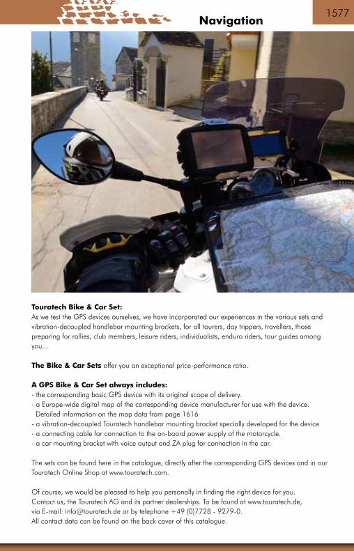
Touratech Bike & Car Set:As we test the GPS devices ourselves, we have incorporated our experiences in the various sets andvibration-decoupled handlebar mounting brackets, for all tourers, day trippers, travellers, thosepreparing for rallies, club members, leisure riders, individualists, enduro riders, tour guides amongyou...
The Bike & Car Sets offer you an exceptional price-performance ratio.
A GPS Bike & Car Set always includes:- the corresponding basic GPS device with its original scope of delivery.- a Europe-wide digital map of the corresponding device manufacturer for use with the device. Detailed information on the map data from page 1616- a vibration-decoupled Touratech handlebar mounting bracket specially developed for the device- a connecting cable for connection to the on-board power supply of the motorcycle.- a car mounting bracket with voice output and ZA plug for connection in the car.
The sets can be found here in the catalogue, directly after the corresponding GPS devices and in ourTouratech Online Shop at www.touratech.com.
Of course, we would be pleased to help you personally in finding the right device for you. Contact us, the Touratech AG and its partner dealerships. To be found at www.touratech.de, via E-mail: [email protected] or by telephone +49 (0)7728 - 9279-0. All contact data can be found on the back cover of this catalogue.

15791578
Zumo 590
zumo 590LM - what‘s included:
- zumo 590LM- Preinstalled City Navigator® NT road maps for Western Europe- 45 countries in Europe (full coverage)- Battery pack- Motorcycle mount and fitting kit- Motorcycle connecting cable- Automotive suction cup mount- In-car connecting cable- Route planning using BaseCamp software (download)- Lifetime map update (download)- Motorcycle mount with power cable and fitting kit- In-car mount with in-car connecting cable- USB cable- Quick-start instructions
060-0530 Garmin Zumo 590 LM Europa *with Lifetime Update*

Navigation15791578
Zumo 590LM special features:
- Transflective display, 5 inch (12.7 cm) screen diagonal- Easy to read even in bright sunlight- Dual-orientation - can be used in landscape or portrait format- Touchscreen with large buttons, glove-friendly- Round trip routing plans an interesting ride according to time, distance or location- Curvy Roads - the zumo 590LM has a special routing function for winding rides- Skip Waypoint - skip the next waypoint on a planned route- Garmin Real Directions guide you with intelligent directions that make navigation even easier, e.g. „turn right at the next traffic lights“ or „turn left at the glass building“- Active Lane Guidancewith voice prompts and split-screen moving images makes it much easier to get in the proper lane at complex junctions and interchanges- Fast routing and map display, intuitive destination searches- Text-to-speech - street names are read out in voice prompts- Its housingis extremely rugged, withstands fuel vapours, UV rays and harsh weather conditions (IPX7 waterproof)- Western Europe preinstalled (full coverage of 45 countries) with Lifetime update- Route planning with Garmin BaseCamp- Bluetooth™ lets you connect to the headset and your mobile phone- Smartphone Link app provides free basic weather and live traffic information while you ride- Displays speed limits
Extras:
- Control your music - the zumo 590LM includes an MP3 player and is compatible with the music database on iPods and iPhones- Service history log helps you keep track of important service intervals, e.g. for oil changes- Digital fuel gauge shows you how many miles you can ride before a fuel stop- Compatible with optional* tyre pressure monitoring system (ANT+ with a range of 3 m)- Garmin VIRB™ Elite action camera compatible - control VIRB using your zumo 590LM display and easily record your ride- zumo 590LM has a built-in trip computer with compass display- Free microSD™ card slot
Garmin Navigation

15811580

Navigation15811580
060-0531 060-0532
Zumo 590
060-0531 Garmin Zumo 590 LM Bike & Car Set *silver*060-0532 Garmin Zumo 590 LM Bike & Car Set *black*
The set comprises the following items:- GARMIN ZUMO 590 LM- TOURATECH lockable handlebar mount for ZUMO 590- Set of bolts for RAM mount adapters
Please also have a look at ourfavourable Bike&Car-Sets! For more Information look underwww.touratech.com.
Garmin Navigation

15831582
Zumo 340/390
As prices vary due to Garmin and tomtom market policy, we are unable to state prices here. Please visit us on the Internet (www.touratech.com) for up-to-date prices

Navigation15831582
Garmin ZUMO 340 | 390 LM
The brand new Zumo is the entry-level model in the Zumo series of navigators. This “kid brother” to the best-selling, tried-and-tested Zumo 660 is a completely revised unit offering a number of innovati-ve improvements. The Zumo‘s new slim casing is an immediate eye-catcher, housing a large 4.3 inch (10.9 cm) touchscreen display that has good readability even in sunlight. Power is provided via built-in connector pins and a cradle that connects to the on-board power supply. Whether on a spontaneous ride after work, a Sunday outing through the mountains or a touring holiday down through Italy – with the Zumo you can be sure of pure riding enjoyment. Thanks to its compact dimensions and stylish black design, the Zumo is also a perfect match for bikes that have less space on the handlebars.
Special features of the Zumo 340/390 LM - Highly visible, sunlight-readable 4.3“ (10.9 cm) display- Glove-friendly touchscreen with large buttons- Two selectable data fields in the display- Speed limit indicator- Route planning with Garmin BaseCamp- Faster routing and map displays, intuitive destination searches- Lane assistant with junction view- Text-to-speech (road names are announced)- Watertight (IPX7), fuel proof, vibration-proofed- Elegant black design- Bluetooth™ for voice output of navigation instructions to headsets- Service history log to record bike maintenance- Free microSD™ card slot- Battery (life up to 7 hours)- Includes motorcycle mount and in-car holder
What‘s included with the Zumo 340LM CE- Zumo 340LM CE- Preinstalled City Navigator® NT road maps for Central Europe (currently 22 European countries with Lifetime update)- Motorcycle mount with power cable (bare ends)- USB cable- Quick-start instructions060-0446 Zumo 340
What‘s included with the Zumo 390 LM - Zumo 390LM- Preinstalled City Navigator® NT road maps for Western Europe - 45 European countries (full coverage)- Route planning using BaseCamp software (download)- Lifetime map update (download)- Motorcycle mount with power cable and fitting kit- In-car holder with car connection cable- USB cable- Quick-start instructions060-0525 Zumo 390
Garmin Navigation

15851584
060-0523 060-0448
Zumo 340
060-0448 Garmin Zumo 340CE Bike & Car Set *silver*060-0523 Garmin Zumo 340CE Bike & Car Set *black*
The set comprises the following items:- GARMIN ZUMO 340CE- TOURATECH lockable handlebar mount for ZUMO 340/350 V3.0- Set of bolts for RAM mount adapters- In-car holder with suction cup- In-car power cable with cigarette lighter plug
Please also have a look at ourfavourable Bike&Car-Sets! For more Information look underwww.touratech.com.

Navigation15851584
060-0448 060-0527 060-0526
Zumo 390
060-0526 Garmin Zumo 390 LM Bike & Car Set *silver*060-0527 Garmin Zumo 390 LM Bike & Car Set *black*.
The set comprises the following items:- GARMIN ZUMO 390 LM- TOURATECH lockable handlebar mount for ZUMO 340/350/390 V3.0 - Set of bolts for RAM mount adapters
Garmin Navigation

15871586
Power cable for Garmin Zumo 590, motorcycle, „with open cable-ends“
065-0422
Garmin ZUMO 590 in-car holder with suction cup
065-0423

Navigation15871586
Power cable for Garmin Zumo 340 / 350 / 390, motor-cycle, „with open cable-ends“
065-0418
Garmin motorcycle bracket Zumo 340 / 350 / 390 *wit-hout cables and mounting adapter*
065-0419
Garmin TPMS valve cap, Tyre Pressure Monitor System (ANT+) for Zumo 390/590Garmin‘s Tyre Pressure Monitor System (TPMS) is an easy and practical way to monitor your motorcycle‘s tyre pressure as you ride, on your Zumo® 390LM display. One TPMS sensor is required for each tyre. Fasten 1 TPMS sensor to each metal tyre valve stem. Now pair the TPMS sensor with the Zumo® 390LM via ANT+ and you can view real-time data right on your z?mo display. TPMS lets you set custom thresholds. If your tyre pressure is too low, TPMS sends an alert. Ride safer with TPMS and detect a slow leak before it puts you in danger.065-0421
Garmin Navigation
Power cable with cigarette lighter plug for *ZUMO 590*
065-0424
Li-ion battery for *eplacement part* for Garmin Zumo 590 LM
065-0425

15891588
TomTom RIDER (2013) Europe „Free lifetime maps“
The best possible TomTom navigation system for motorcyclists. Cruise the most exciting winding roads or take the fastest direct route to your destination. Enjoy the ride in any conditions - the TomTom RIDER is easy to operate and ruggedly built to withstand whatever the road throws at it.
Features:- Preinstalled map data with road maps for 45 European countries and special Biker POIs- Rugged, waterproof, vibration-proof housing (IPX7)- High-performance touchscreen display remains visible even in glaring sunlight - The RIDER‘s screen is also glove-friendly- Robust motorbike mount with RAM® mount universal device holder- On-board power supplied via motorcycle battery connecting cable - Advanced lane guidance (clearly shows which lane to take at road junctions and on motorways)- Attractive routing suggestions with Winding Roads - Find routes online, upload to your TomTom RIDER and go- TomTom IQ Routes - intelligent, individual routing - Displays speed limits in towns and on main roads and motorways- Record routes and share with other RIDER users online or via Bluetooth
- Turn on/off with ignition- The TomTom RIDER powers on/off with your bike‘s ignition, which means your TomTom RIDER is ready to ride when you are.

Navigation15891588 TomTom
What‘s included with the TomTom RIDER:
- TomTom RIDER- RAM universal device holder - Active bike dock - motorcycle mount and 12 V battery cable- AC charger- Preinstalled map data with road maps for 45 European countries
060-1406 TomTom RIDER (2013) Europe „Free lifetime maps“060-1408 TomTom Rider 2013 Bike & Car Set „Free Lifetime Maps“
Vehicle mounting TomTom Rider 2013With the car mounting set you can also use your TomTom Rider 2013 in your automobile. The car mounting set has an integrated speaker for voice instructions to enable you to enjoy all the benefits of automobile navigation.
Supplied with:- Suction cup mount- TomTom Rider 2013 automobile mounting- Cigarette lighter cable- Integrated voice output for TomTom Rider 2013
065-1085

15911590
IPX7 *
ODB *
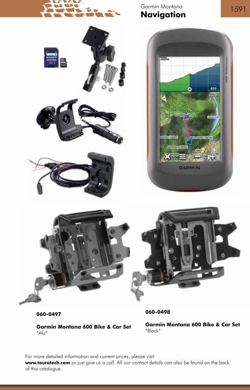
Garmin Montana
The all-round talent.
The Garmin Montana offers ideal applications for many different purposes. The spectrum of the Montana series ranges from wal-king and geocaching, for use on motorbikes, in cars or on quads, through to maritime capability. The Montana models are extremely ro-bust and absolutely watertight. They are comfortable to hold and can be intuitively operated using the superlative large touchscreen. All
manner of shortcuts can be configured in the Montana. The settings, preconfigured for outdoor, vehicle or marine usage and tuned to the respective areas of application, can be easily called up by the user.
Depending upon where it is being used, the Montana can be fitted with optional topographical maps, maritime charts or road maps from Garmin. The outstandingly readable and brilliant „flip-flop“ display accurately shows the smallest details on the maps. With the optionally available motorbike or vehicle mounting brackets, the Montana can be attached to the handlebar or car windscreen and powered using the onboard electrics system. It is also equipped with a unique, dual battery system that can accommodate both a lithium-ion rechargeable power pack or type AA batteries.
Includes:- Garmin Montana- USB cable- AC charger- User manual on CD- Quick-start instructions- Lithium-ion rechargeable power pack with the Garmin Montana 650 and 650t.
060-0494 Garmin Montana 600
060-0495 Garmin Montana 650Camera, 5 megapixels
060-0496 Garmin Montana 650tCamera, 5 megapixels / Europe leisure map
Navigation15911590 Garmin Montana
For more detailed information and current prices, please visit www.touratech.com or just give us a call. All our contact details can also be found on the back of this catalogue.
060-0497
Garmin Montana 600 Bike & Car Set *Alu*
060-0498
Garmin Montana 600 Bike & Car Set *Black*
15931592
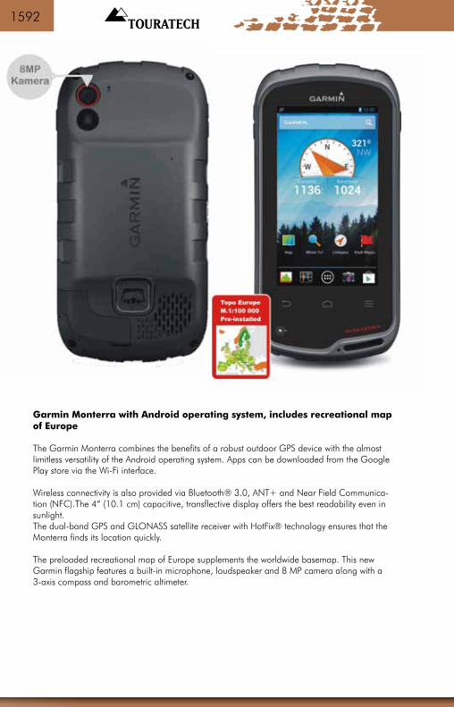
Garmin Monterra with Android operating system, includes recreational map of Europe
The Garmin Monterra combines the benefits of a robust outdoor GPS device with the almost limitless versatility of the Android operating system. Apps can be downloaded from the Google Play store via the Wi-Fi interface.
Wireless connectivity is also provided via Bluetooth® 3.0, ANT+ and Near Field Communica-tion (NFC).The 4“ (10.1 cm) capacitive, transflective display offers the best readability even in sunlight.The dual-band GPS and GLONASS satellite receiver with HotFix® technology ensures that the Monterra finds its location quickly.
The preloaded recreational map of Europe supplements the worldwide basemap. This new Garmin flagship features a built-in microphone, loudspeaker and 8 MP camera along with a 3-axis compass and barometric altimeter.

Navigation15931592
Features
- Capacitive, transflective touchscreen, 4“ (10 cm) diagonal- Dual orientation display: automatic switching to portrait or landscape format when turned through 90 degrees- Lithium-ion rechargeable battery pack or AA batteries/rechargeable batteries can be used- External power supply via motorbike or car mount available as an option- Waterproof to IPX7 (30 minutes in up to 1 m depth of water)- ANT+: wireless data sharing with other compatible devices- Optionally available Garmin City Navigator NT map provides auto-routing with lane assistant- Android 4.0 operating system allows unlimited use of Google Play store- High-sensitivity GPS and GLONASS receiver with HotFix® technology- Robust and waterproof to IPX7- 8 MP camera with LED flash/torch- Connect and share data via Wi-Fi, Bluetooth® 3.0, ANT+ and Near Field Communication (NFC)
What‘s included - GARMIN Monterra
- Garmin Monterra- Recreational map of Europe, scale 1:100,000- Worldwide basemap- USB cable and AC adapter- Lithium-ion battery- Screen protector- Quick-start instructions
060-0585
Garmin Monterra

15951594
POI *
IPX7 *
ODB *
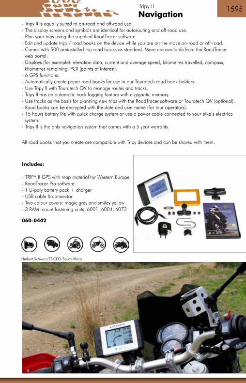
Tripy II
The Tripy II GPS system. A new way of seeing things.- Do you like riding a motorbike?- Do you like scenic motorbike routes?- Do you always want to know which way you should go?- Do you like creating road books and trips to use as a tour guide?
If you answered “yes” to any of the questions above, Tripy II is the navigation system for you!
Tripy II is about motorcycling: the experience, the scenery and the route, not the GPS device. Tripy II only displays the information that’s really important. You play a dynamic part in the route guidance system, and you’re always in the picture on how the trip is going
Tripy II uses rally co-driver pictograms to guide you on your trips – these have been tried and tested countless times. Tripy II does indeed know the most scenic routes, because we’ve tested it! At the same time, Tripy II is easy to use. It gives clear turn-by-turn directions that anyone can understand. You’re always part of the route and never just an observer watching the screen.
Tripy II helps you- Appreciate the scenery and enjoy riding your motorbike!- Easily find your way to pleasures and attractions- Plan your next trip in advance- Experience other motorcyclists’ trips
More features & details- Tripy II uses the same pictograms and tripmaster functions as professional rally teams.- B&W monochrome screen for excellent readability even in the most extreme lighting conditions.- Extremely resilient housing and buttons – fully dust and waterproof (IPX7).- Tripy II is fully “routing-enabled” and can automatically recalculate routes for detours and diversions. - Complete detailed data for Western Europe is preinstalled along with Tele-Atlas detailed data. Countries: AT, BE, CH, ES, FR, GB, GR, IE, IT, LU, PT. 800,000 points of interest preinstalled.
Navigation15951594
Herbert Schwarz/TT-CEO/South Africa
- Tripy II is equally suited to on-road and off-road use.- The display screens and symbols are identical for autorouting and off-road use.- Plan your trips using the supplied RoadTracer software.- Edit and update trips / road books on the device while you are on the move on-road or off-road.- Comes with 500 preinstalled trip road books as standard. More are available from the RoadTracer web portal.- Displays (for example): elevation data, current and average speed, kilometres travelled, compass, kilometres remaining, POI (points of interest). - 6 GPS functions.- Automatically create paper road books for use in our Touratech road book holders.- Use Tripy II with Touratech QV to manage routes and tracks.- Tripy II has an automatic track logging feature with a gigantic memory.- Use tracks as the basis for planning new trips with the RoadTracer software or Touratech QV (optional).- Road books can be encrypted with the date and user name (for tour operators).- 15 hours battery life with quick charge system or use a power cable connected to your bike’s electrica system.- Tripy II is the only navigation system that comes with a 5 year warranty.
All road books that you create are compatible with Tripy devices and can be shared with them.
Includes:
- TRIPY II GPS with map material for Western Europe - RoadTracer Pro software - 1 Li-poly battery pack + charger - USB cable & connector - Two colour covers: magic grey and smiley yellow- 3 RAM mount fastening units: 6001, 6004, 6073
060-0442
Tripy II

15971596
Data cards / memory modules
The various GPS systems made by Garmin, TwoNav and TomTom that are marked with one of the symbols (pp. 942 ff.) allow additional maps to be loaded and displayed on the map screen using memory cards. This data is loaded onto the device in addition to its preinstalled maps, and can be used as desired.The compatible GPS devices have a built-in slot that takes an SD or microSD card. The SD/microSD data cards that are shown here can be used alternatively as an SD or microSD card with the integrated adapter.
These removable data cards offer you a high level of flexibility and can store large amounts of detailed information, trip data or photos, for example. By using multiple data cards you can take all kinds of different maps with you – for example city maps or topo-graphic maps for a long journey.
Tip: Garmin offer a large selection of detailed, TOPO and leisure maps, some of which are preinstalled on SD/microSD cards. For more information, please see pp. 1616 ff. in the catalogue.
SD & microSD data card *Sandisk* 2 GB 065-0493
SD & microSD data card *Sandisk* 8 GB 065-0494
SD & microSD data card *Sandisk* 16 GB 065-0495
As prices are constantly changing, please consult the GPS price list for current prices or visit our online shop at www.touratech.de

Navigation15971596 Easy Routes
easyRoutes 3 ® -GPS-Tourenplaner*Downloadversion*
This GPS planning software is only available in German langua-ge.
090-4801

15991598
outdoor

Navigation15991598

16011600
060-1007
GPS Map 64 / 64s / 64st The GPSmap 64 is a robust and waterproof hand-held navigation device which works reliably even under the most arduous and tough conditions. It is suitable for an extremely broad range of uses: from hiking and biking, mountaineering or geocaching to professional expeditions. The GPSmap 64 offers excellent user-friendliness, starting with a contrast-rich 6.6 cm colour display which is easy to read, even under harsh sunlight. The device fits the hand perfectly and can be operated via keys, even allowing easy operation with gloves, on bumpy tracks, or during cold or wet weather. The internal memory offers adequate storage for tracks and caches, and the microSD map plug-in is available for additional map material. The dual battery system is also extremely practical with a battery life of 16 hours to ensure that the fun does not stop early.
Special features of the GPSmap 64 family:- Faster satellite acquisition through GPS and GLONASS compatibility - Dual battery system: battery life up to 16 hours with standard AA batteries or Garmin power pack - Larger internal memory 4GB at 64/64s and 8GB at 64st with memory extension using the microSD map slot - Stores up to 5,000 way points - Paperless geocaching with 250,000 pre-installed caches from Geo-caching.com - Contrast-rich and sunlight readable 6.6 cm (2.6“) colour display - Robust and waterproof according to IPX 7 - Proven key operation, also with gloves - ActiveRouting functions with suitable TOPO PRO maps from Garmin - Compatible with other map formats (BlueChart g2, CityNavigator NT) Additional functions of the GPSmap 64s and st:- Bluetooth® 4.0 (Smart/ Low Energy) for linking with Smartphone Apps (BaseCamp Mobile and Garmin Connect Mobile) 1 - Live tracking via Garmin Connect Mobile1 - Smartphone messaging ( E-mail, SMS, appointments, calls) via Blue-tooth® connection to iPhone 4S or newer - 1 year subscription to BirdsEye Satellite Imagery (download via BaseCamp) - Barometric altimeter & 3-axis compass - Data transfer per ANT+ to GPS devices or sensors (i.e. HF chest strap, pedal frequency or tempe) Only for GPSmap 64st:- Pre-installed recreation map Europe, scale 1:100,000 - 8GB internal memory - basic map of world - USB cable- snap hook - handbook- pre-installed recreation map of Europe- 1 year subscription Birds Eye Satellite
Scope of delivery GPSMAP 64: 060-1007 - basic map of world - USB cable- snap hook - handbook
Scope of delivery GPSMAP 64s: 060-1008- basic map of world - USB cable- snap hook - handbook- 1 year subscription to Birds Eye Satellite
Scope of delivery GPSMAP 64st: 060-1009- basic map of world - USB cable- snap hook - handbook- pre-installed recreation map of Europe- 1 year subscription Birds Eye Satellite

Navigation16011600 Garmin GPS Map
GPS Map 78 / GPS Map 78s
The GPS Map 78 / GPS Map 78s is designed for maritime use and offers everything you need in one of the most stable and universal navigation systems available. The GPS Map 78 series is in the top league of GPS handheld units. The unit’s tough case with new, specially moulded side grips made of rubber also contains the high sensitivity receiver. Its transflective display shows optional map material in colour. Maps can be loaded in the unit via microSD™ cards.
The GPS Map 78 series can use all kinds of different maps. MapSource maps can be used on optional microSD or SD memory cards. City Navigator maps offer turn-by-turn directions and navigation results with house number accuracy. In conjunction with Touratech QV you can load sections from all our raster maps onto the 78 series models. Use our Touratech handlebar mount, mounting adapters and the tried-and-tested Garmin round plug to fit a 78 model very securely on your motorbike.
The motorbike GPS system for all adventurers and long-distance travellers that also supports your outdoor activities.
Special features of the Garmin GPS Map 78:
- Rugged case with the new specially moulded side grips made of rubber- Transflective display even for difficult lighting conditions- Proven Garmin operating keypad- High-sensitivity GPS receiver with HotFix™ satellite prediction- Built-in worldwide basemap enabling effortless, quick orientation on the map- Expandable with topographic maps, BlueChart g2 marine maps and MapSource street maps- Store up to 200 tracks complete with up to 10,000 points- Memory for 2,000 waypoints, 200 routes and 200 tracks- Compatible with microSD cards (up to 4 GB)- USB port as PC connection- Floats, waterproof to IPX7 standard
Only on the Garmin GPS Map 78s:
- High speed USB 2.0 port for extremely fast connection to a PC- Wireless data transmission between devices- Built-in 3-axis electronic compass and barometric altimeter
Includes: GPS MAP 78 or 78s, Wrist strap, USB cable, Quick-start instructions
060-0481 Garmin GPS Map 78 060-0480 Garmin GPS Map 78s
Scope of delivery GPSMAP 64: 060-1007 - basic map of world - USB cable- snap hook - handbook
Scope of delivery GPSMAP 64s: 060-1008- basic map of world - USB cable- snap hook - handbook- 1 year subscription to Birds Eye Satellite
Scope of delivery GPSMAP 64st: 060-1009- basic map of world - USB cable- snap hook - handbook- pre-installed recreation map of Europe- 1 year subscription Birds Eye Satellite

16031602
Garmin Oregon 600 / 600tOregon 600/600t - enjoy outdoor activities with cutting-edge technologyThe new robust and waterproof Oregon GPS series offers more features, better performance and the most brilliant sunlight reada-ble touchscreen ever on a Garmin handheld device. Pick up the Oregon 600 and you are ready for a whole new world of Garmin
outdoor navigation. High-sensitivity GPS and GLONASS (Russian satellite system) satellite tracking enables super-fast positioning in any terrain. Thanks to the extremely fast processor and preloaded worldwide basemap with shaded relief, you don‘t just look at maps - you intuitively interact with them. Zoom, move, rotate - multi-touch even works with most types of gloves. The reflective display enhances the brightness of the touchscreen to make maps and information just as readable in bright sunshine as in the shade.
Other features and specifications- Oregon 600/600t 750 MB built-in memory- Recreational map of Europe: scale 1:100,000 preloaded (600t)- Preloaded worldwide basemap with shaded relief- Expandable with microSD cards up to 4 GB- Battery life approx. 16 hours in standard GPS mode- IPX7 waterproof- Wireless connectivity via ANT+ for use of optional wireless ANT+ sensors- Wireless data sharing between devices- Bluetooth and Bluetooth low energy compatible- Paperless geocaching feature- ActiveRouting with compatible Garmin Topo maps (optional) - Extremely resilient plastic housing- Capacitive 3“ touchscreen display (with multi-touch)- GPS and GLONASS compatible (up to 20% faster GPS reception)- Customisable shortcut button- An optional NiMH battery pack charges automatically when the device is connected to an external power source
What‘s included - Oregon 600t/ 600t- Recreational map of Europe: scale 1:100,000 preloaded (600t)- Worldwide basemap (preinstalled)- USB/charging cable 060-0575 Oregon 600- Carabiner 060-0576 Oregon 600t- Documentation (download)
Navigation16031602
060-0579
060-0578
060-0577
Garmin Oregon
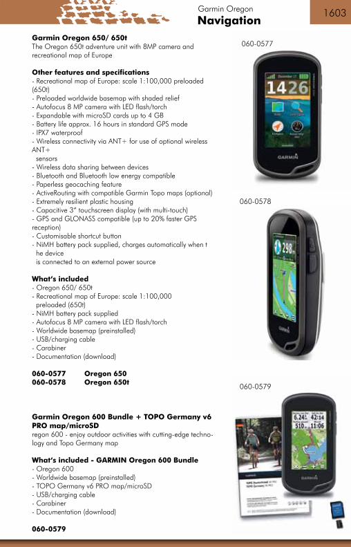
Garmin Oregon 650/ 650tThe Oregon 650t adventure unit with 8MP camera and recreational map of Europe
Other features and specifications- Recreational map of Europe: scale 1:100,000 preloaded (650t)- Preloaded worldwide basemap with shaded relief- Autofocus 8 MP camera with LED flash/torch- Expandable with microSD cards up to 4 GB- Battery life approx. 16 hours in standard GPS mode- IPX7 waterproof- Wireless connectivity via ANT+ for use of optional wireless ANT+ sensors- Wireless data sharing between devices- Bluetooth and Bluetooth low energy compatible- Paperless geocaching feature- ActiveRouting with compatible Garmin Topo maps (optional) - Extremely resilient plastic housing- Capacitive 3“ touchscreen display (with multi-touch)- GPS and GLONASS compatible (up to 20% faster GPS reception)- Customisable shortcut button- NiMH battery pack supplied, charges automatically when t he device is connected to an external power source
What‘s included - Oregon 650/ 650t- Recreational map of Europe: scale 1:100,000 preloaded (650t)- NiMH battery pack supplied- Autofocus 8 MP camera with LED flash/torch- Worldwide basemap (preinstalled)- USB/charging cable- Carabiner- Documentation (download)
060-0577 Oregon 650060-0578 Oregon 650t
Garmin Oregon 600 Bundle + TOPO Germany v6 PRO map/microSDregon 600 - enjoy outdoor activities with cutting-edge techno-logy and Topo Germany map
What‘s included - GARMIN Oregon 600 Bundle- Oregon 600- Worldwide basemap (preinstalled)- TOPO Germany v6 PRO map/microSD- USB/charging cable- Carabiner- Documentation (download)
060-0579

16051604
Garmin Edge® - Touring Plus *Bikecomputer* with Garmin Cycle Map
Wherever you are, find your wayEdge Touring Plus works like the GPS navigator you use in your car, only with maps and features specifically designed to help you find your way by bike. Whether you have a specific destination in mind, or just a distance you want to ride, Edge Touring Plus gives you the freedom to know you can find your way. You can even find and download rides others have completed on Garmin Connect and Garmin Adventures, or share your own with the community. The edge touring plus tracks your distance, speed, location and ascent/descent. Find Places and Get Directions Bike-specific maps preloaded in Edge Touring Plus make it easy to get from point A to point B (and beyond) and back again. Simply enter an address or search for points of interest and Edge Touring Plus will give you turn-by-turn directions to your destination(s). You can choose between cycling, tour cycling and mountain biking modes to calculate the most appropriate route for the type of cycling you do, taking you on paved roads, unpaved roads or on paths and trails. With round trip routing, you can tell Edge Touring Plus how far you’d like to ride and then choose from up to 3 ride options that will bring you back to where you started. The device makes it easy to plan rest stops, find attractions along the way and more. Get the height advantage The Barometric Altimeter in the Edge Touring Plus gives elevation, total ascent, total descent and gradient information on the go. It also displays a graph of the elevation changes and records the elevation data for upload when you get home. Connect to Your Edge Use Edge Touring Plus with a wireless ANT+™ heart rate monitor (sold separately) to help you track and log how hard you’re working. This ANT+ technology also provides integration for com-patible LEVs and eBikes to show range, remaining charge and other key data. Search for Rides and Adventures Don’t have a specific destination in mind? Search for rides others have completed on Garmin Connect or Garmin Adventures. Then download them to Edge Touring Plus to follow on your next ride. Customise the rides or create completely new ones and then download them to your device as well. Share Your Experiences Edge Touring Plus records where you ride so you can upload your rides to Garmin Connect or Garmin Adventure and relive them whenever you want. Garmin Connect and Garmin Adventures are free and allow you to share your cycling adventures with friends, family or fellow riders.

Navigation16051604
060-0379
+ Garmit Cycle Map
Garmin Edge
Additional product highlights
- On-road or off-road navigation with preloaded Garmin Cycle Map- Input a distance and choose from up to 3 round-trip ride options - Plan and download new routes to follow- Relive and share your rides with Garmin Connect™ or Garmin Adventures- Points of Interest (POIs) specifically for cyclists- Compatible with optional heart rate monitor- Barometric Altimeter for detailed elevation information
Supplied with - Edge Touring Plus- Quarter-turn bike mount- USB cable- Garmin cycling map on microSD™ card (pre-inserted in Edge)- Quick Start Manual
060-0379 Garmin Edge® - Touring Plus *Bikecomputer* with Garmin Cycle Map

16071606

Navigation16071606 Garmin Edge
Garmin tempe™- Temperature radio sensor
Transmit ambient temperature data wirelessly to your device with the tempe external wireless temperature sensor. Attaches to your pack, jacket or shoe.
060-0373
Garmin Edge® Aero Bike Bar Mount
Put you and your data ahead of the pack with this out-front bike mount.This mount allows you to take full advantage of all of the robust data that Edge provides without com-promising the ride. The Edge is out in front of you for easier, heads-up positioning and increased safety.
060-0734
Garmin Premium heart rate monitor *soft strap*
This heart rate monitor has a soft fabric strap and is more comfortable than ever before. Plus, it‘s op-timized for use in congested areas like gym classes and starting lines.
065-0347

16091608
Garmin Fenix 2™/ GPS Outdoor Watch
Combining the best features of our fitness and outdoor watches, the fenix 2 is the ideal multisport athlete‘s training partner. Whether running, climbing, riding, hiking, paddling, skiing or swimming, the fenix 2 lets you easily switch between feature sets for easier access to the information you need. Switch from advanced fitness training features like VO2 max, Virtual Partner® and recovery advisor to high-sensitivity GPS tracking features like 3-axis compass and TracBack®. And with Smart Notification you can stay in touch, even while you‘re out testing your mettle.
Full Featured Training Watch for Multisport Athletes- Tracks distance, pace and heart rate¹- Calculates recovery time and VO2 max estimate (when used with a heart rate monitor¹)- HRM-Run™ monitor¹ adds data for cadence, ground contact time and vertical oscillation- Connected features², including uploads to Garmin Connect™ and BaseCamp™ for live tracking and sharing- High-sensitivity GPS positioning, 3-axis compass with altimeter and barometer
What‘s included:- fenix 2 GPS watch- HRM-Run™- Fabric wrist strap kit- USB charging/data cable- AC adapter- Quick start manual
060-0398 Garmin Fenix 2™/ GPS Outdoor Watch

Navigation16091608
Time
Garmin Fenix 2
LiveTrackCompass
Map
Garmin Fenix 2

16111610
Suunto watches
Especially on long trips, modern technology offers many options for calculating routes, determining altitudes, compass points, weather forecasts and much more. There are several reasons why we always take our SUUNTO watches with us. On the one hand, they are very reliable, durable and, in our opinion, have a very stylish design. On the other hand, because of their many functions they can replace other units if these are out of order. If, for example, the GPS receiver is no longer working, you will still have a compass to get back on the right track. The watches made in Finland have a lot of useful functions. You will find a more detailed description on our website www.touratech.com.
For more detailed information on Suunto products, please visit our Internet shop at www.touratech.com and go to the Navigation section.
SUUNTO Watch Elementum *Terra*
The Suunto Elementum Terra is a fusion of deca-des of outdoor experience with precision crafts-manship, and is an elegant watch with features that will enthral every true adventurer. Equipped with the most important functions
– an altimeter for determining the altitude, a barometer for easily predicting changes in the weather, together with a compass for navigation
– the Terra provides critical information you can rely upon in both everyday life in the city as well as when exploring the great outdoors. More than just a watch.
Weight: 95 g
060-0715

Navigation16111610
Compass Suunto MB-6 *Global System*
- Turbo needle system: the inclination (intensity of the magnetic field of the earth) does not influence the needle; this compass functions anywhere (!) on the earth.- Mirror folds out automatically. Rugged housing- Adjustable declination (difference between magnetic and geographic North Pole)- Clinometer - Transparent dial facilitates map reading.
060-1005
Compass Recta DS40
- Transparent base plate and dial for map reading - Sapphire jeweled bearing- Luminous markings - Folding, mirorr integrated in lid- Oil-damped - Clinometer scale on the lid- Base plate 52 x 75 mm- 130 mm ruler
060-1001
Suunto watches
SUUNTO X-LANDER
Harmony of technology and style.
- Chronometer,- altimeter and barometer- thermometer, - electronic compass,- 3 alarms/alarm clock settings.- Stylish aluminium housing, - Weight 65 g.
060-0709

16131612
SPOT Gen3 - Satelliten GPS Messenger orange
When your adventures take you beyond cell service, SPOT Gen3 lets family and friends know you‘re ok or sends emergency res-ponders your GPS location, all at the push of a button. Add this rugged, pocket-sized device to your essential gear and stay con-nected wherever you roam. Long live adventure. SPOT Gen3‘s customized tracking features takes your SPOT experience to the next level. Only with SPOT Gen3, is tracking motion-activated regardless of the level of tracking you choose (Basic, Unlimited or Extreme). A vibration sensor tells your SPOT to send track updates when you are moving and to stop when you do.
SOS: Use this function In the event of a life threatening or other critical emergency to notify emergency services of your GPS location and that you need assistance. The GEOS International Emergency Response Center alerts the appropriate agencies worldwide - for example contacting 9-1-1 responders in North America and 1-1-2 responders in Europe.
Help: In the event of a non-life threatening emergency, you can use this function to notify your personal contacts that you need assistance. Additional SPOT Assist services can be purchased and programmed to your Help button as well. When activated with SPOT Assist, the Help button will notify professional services either on the land or water. SPOT has partnered with national service providers to offer non-life threatening assistance.
Check-in/OK: This feature allows you to let your friends and family know that all is OK with a pre-programmed message along with your GPS location. With a push of a button a message is sent via email or SMS to up to 10 pre-determined contacts and your waypoint is stored in your SPOT account for later reference. Your stored waypoints can be easily integrated into a SPOT Shared Page or SPOT Adventure account.
Custom Message: This feature allows you to let your friends and family know receive a custom message along with your GPS location with a push of a button. Use this feature as a secondary OK message or transfer your personal help alert to this message function if you are using a SPOT Assist service on your Help button.
Track Progress: Start/stop tracking at any time using your SPOT device (Additional service required). You can also mark a Reference Point or send Check-in/OK messages from specific locations while in Track Progress mode.
In order to use these functions it is obligate to register for the corresponding service at www.find-mespot.com . These are the corresponding costs. (BASIC SERVICE: 138,- €)
Supplied with:- SPOT Gen3 Messenger- instructions- USB cable- Carrying loop- Energizer Ultimate Lithium AAA batteries- Carabiner holde
060-1524

Navigation16131612 GPS Messenger
Spot Trace
The SPOT Trace offers advanced theft-alert tracking for anything. Instantly receive a text or email when your most valu-able assets move, or follow them on Google Maps anytime on your phone or computer. Custom tracking options allow you to select the rate at which updates are sent - every 2½, 5, 10, 30 or 60 minutes.Affordable and easy to use, SPOT Trace is a no-brainer for your cars, boats, motorcycles, toys and other valuables. NO WORRIES.
Features:-Custom Tracking-Movement Alerts-Quick Setup-Easily Mountable-Rugged + Waterproof-Long Battery Life-Line Power Option - Receive text/email messages when movement is detected- Satellite technology tracks beyond the reach of traditional cellular coverage- Monitor assets in near real-time using Google Maps- Long battery Life, compact & easy to install- Select from 2 1/2, 5,10,30 or 60 minute tracking intervals
In order to use these functions it is obligate to register for the corresponding service at www.findmespot.com . These are the corresponding costs. (BASIC SERVICE: 119,- €)
Supplied with:- SPOT Trace Device- Quick Start Guide- AAA Energizer® Ultimate Lithium 8x batteries- Line power with a 5v USB connection (NOT waterproof)- Mounting Accessories
060-1525
You will find more details and information at www.touratech.com. Click on GPS Navigation.

16151614
Pic.: Dirk Schäfer | Morocco

Navigation16151614
SPOT CONNECT
Today’s smartphones provide a level of social connection far beyond what we imagined just a few years ago. But when you go beyond the reach of the grid, your smartphone needs the help of SPOT Connect to keep you in touch with friends, family, and emergency personnel. Simply pair your smartphone with SPOT Connect, and get connected to a global satellite network that lets you send messages and GPS coordinates from virtually anywhere on the planet. Update Twitter and Facebook. Request non-emergency help from professional service providers. And in the case of a critical emergency, send an SOS message requesting emergency assistance.
How it works:Download the SPOT app and pair your smartphone with SPOT Connect via Bluetooth. SPOT Connect links your smartphone to Globalstar communication satellites. You now have near-global access to the SPOT services.
Spot Messages Service:Basic Service plan – standard service with 12-month contract (EUR 99/year):- Emergency messages (Help and SOS messages)- Predefined updates for Facebook and Twitter with GPS location- Predefine 14 different messages and up to 10 different contact groups- Basic Service plan includes 200 text messages per year (EUR 0.10 for each additional message) and
unlimited e-mailing
Please note: You need to register on FindMeSpot, where you can order the SPOT Basic Service plan and additional services.
Supplied with:- SPOT Connect- 2 x AA Energizer Ultimate Lithium 8X (L91) batteries- Quick-start guide (multi-language)
060-1650
GPS Messenger

16171616

Navigation16171616 Maps
BaseCamp™
Make the most of your next outdoor activity or relive the trips you’ve taken. BaseCamp lets you plan outdoor activities, organi-ze your data and share your adventures with others.
FeaturesPlan a Trip
Use BaseCamp to plan your next hiking, biking, motorcycling, driving or off-roading trip. You can view maps, plan routes, and mark waypoints and tracks from your computer and then transfer them to your device.
• Track Draw feature lets you trace your planned route and view elevation changes, helping you estimate the difficulty of a hike or bike ride.• Plan the perfect scenic route for your next road trip, making sure your navigator takes you through certain waypoints.• Play back your routes and tracks over time and save and share your adventure.
Survey the Terrain:BaseCamp displays your topographic map data in 2-D or 3-D on your computer screen,including contour lines and elevation profiles. Load map data from your handheld device, orimport maps you’ve downloaded or purchased on DVD or microSD™ card. Consider ourTOPO series maps, which offer detail on a scale of either 1:100,000 or 1:24,000.

16191618
DVD Garmin City Navigator NT Europe
The CityNavigator NT (new technology) version
- with a higher data com-pression ratio for map data
- for all NEW GPS units since approx. 2005
Intended primarily for GPS units with external memory or units with preinstalled map data.
Such as the Zumo 660 or Zumo 220.
090-0368
nüMaps Lifetime Update CN Europa *Online Update no DVD*
090-0323
You will find more technical details and information at www.touratech.com. Click on GPS Navigation.
City Navigator Map Data
This means, making navigation easy. Download the City Navigator NT map data directly onto your device or use an SD memory card. This gives you information on turn-offs to endless addresses and road junctions. Prepare routes to points of interest, i.e. restaurants, petrol stations, accommodation, landmarks and much more. The map covers towns in detail as well as the comprehensive road network of the respective countries. Information on the entire data covered is given in the product information on our WEB Shop.Powered by NAVTEQ, a worldwide leading provider of high-quality digital map data.
- displays motorways, national and regional roads as well as roads in towns- includes points of interest, i.e. restaurants, accommodation, landmarks, petrol stations- provides turn-off instructions on compatible devices- language version for compatible devices, example: „Turn left onto the main road“- navigation functions such as roundabouts, speed limits and more- traffic data for compatible devices with traffic news receivers
To display and use Garmin City Navigator or Topo Maps, you require a compatible device with mi-croSD/SD memory card slot. Maps on microSD/SD memory cards cannot be copied onto computers. The microSD/SD memory card pack includes a microSD memory card and an SD memory card adapter. These maps can be used via the respective GPS device in Basecamp (page 1617) and used for planning.

Navigation16191618
Garmin City Navigator® North America NT GARMIN MapSource format
With over 10 million points of interest and road coverage for US, Canada and Mexico, City Navigator North America NT gives you everything you need to travel North America. Powered by NAVTEQ, a world leader in premium-quality digi-tal map data, City Navigator brings you the most detailed street maps available so you can navigate with exact, turn-by-turn directions to any address or intersection.
090-0402 DVD
090-0684 microSD™/SD™ card
SD,microSD Garmin City Navigator® South America NT
Navigate the streets with confidence. This product provides detailed road maps and points of interest for your device, so you can navigate with exact, turn-by-turn directions to any address or intersection.
090-0403
MapSource R+R World CD ROM V4
The WorldMap has an exceptional position. It includes a world map with limited accuracy. Country borders, cities, towns, lakes and rivers, motorways, main lines of communication and railway lines, pet-rol stations, restaurants, hotels, camping sites, coast lines and many islands, navigation aids worldwide such as lighthouses, buoys etc.For European regions, WorldMap is less accurate than the Basemap that is already integrated into street navigation units.
MapSource R+R World CD ROM V5090-0036
Maps

16211620

Navigation16211620
Garmin TOPO Germany v6 PRO, DVD complete *includes microSD card*Features
TOPO Germany v6 PRO offers an out-standing range of features. Its new, unique ActiveRouting capability plans routes to match your leisure activities. Simply enter your mode of transportation to see your desired personalised route at a glance. This is your active leisure compa-nion for hiking, motorbiking or bicycling - or simply for a peaceful stroll outdoors
Garmin has stepped up its collaboration with experts in hiking, mountain climbing and bicycle touring. With the new TOPO Germany v6 PRO, discover the complete 350,000-plus km of the cycling route network from ADFC, the German cycling association. There is also a much improved street name search with number accuracy.Experience a whole new dimension in premium outdoor navigation.
TOPO Germany v6 PRO provides users with a wealth of information yet always gives an optimal overview combined with maximum depth of detail. Modern vector technology in the map provides increasing detail as the view is enlarged while always keeping things well organised and clear for the user. Thus many buildings are shown only at high levels of detail. Moreover, individual elements on the map can be clicked any time to view additional information such as path names or vegetation types.- Provides precise topographic maps at a reference scale of 1:25,000.
What‘s included:- DVD with TOPO Germany map data and BaseCamp- microSD card preloaded with TOPO Germany- microSD card adapter for SD card format- Licence terms and activation instructions
090-0416
MapsMaps
Garmin Topo-Maps
Use optimised topographic details on compatible devices - no matter whether you are in the outbacks or the middle of a town. These maps offer you a variety of topographical information, from terrain contours, elevations, summits, paths and trails to lakes, rivers and streams in the respective countries.
- terrain contours, elevation lines and summit points and a detailed view of the terrain- paths, roads and trails are covered in the map- hydrographic features: shore lines of lakes/rivers as well as permanent and seasonal waterways- integrated DEM data (digital elevation model) with 3D shading and route elevation profiles- elevation profiles to assess difficulty of terrain on compatible devices- points of interest in towns and the countryside. Detailed information depending on map.- ensure that your device is compatible with this product prior to purchase.
To display and use Garmin Topo maps on memory cards, you require a compatible device with microSD/SD card slot. Maps on microSD/SD memory cards cannot be copied onto a computer. The microSD/SD memory card pack contains a microSD memory card and an SD memory card adapter. These maps can be displayed by the respective GPS device in Basecamp (page 1617) and used for planning.

16231622
DVD Garmin TOPO TransAlpin V4 PRO *Alpine regi-on D, CH, AT, IT* *includes microSD card*
For anyone planning to traverse the Alps or enjoy leisure time in the region – Garmin TransAlpine is the first cross-border vector map for Garmin GPS devices. The TransAlpine topo map also includes additional premium content for all kinds of outdoor acti-vities to guide you across the Alps in safety and comfort.
Coverage: Cross-border outdoor navigation. For the first time Garmin offers a cross-border detailed topographic map for the Alpine region. Covers parts of southern Germany, western Austria, northern Italy, western Slovenia and eastern Switzerland. Plus detailed coverage of the Eastern Alps.
For crossing the Alps by mountain bike
The entire trail network from the classic “Traumtouren Transalp” by Uli Stanciu with the famous 18 routes across the Alps. Total of more than 9,200 km of the best routes across the Alps with around 300,000 m of altitude difference on more than 600 stages. As well as the 18 dream tours, the map provides numerous connecting trails and alternative routes from the “Traumtouren Transalp” book. With an overview of the stages of the trip (distance and altitude difference) and route planning tips. For crossing the Alps on foot
All stages of the famous E5 long-distance hiking route between Lake Cons-tance and Verona. With stage overview and route planning tips.
Alpine POIs- 21,000 mountain peaks with eleva-tion data- 2,400 passes and cols with elevation data- 2,000 mountain shelters and refuges with elevation data, some with contact telephone numbers; more than 700 mountain railways/cableways with more than 300 outdoor and cycling shopsRouting
The entire trail network contained in Garmin TransAlpine is routing-enabled.090-0377
For more maps, details, information and prices please visit www.touratech.com
Garmin TOPO Austria V4 Let us be your outdoor guide to paths, trails, shelters, lakes, mountains and more in Austria. With 1:25,000 scale topographic mapping, this product is fully loaded with new features, so whether out for a hike or a climbing tour, TOPO Austria v3 will get you where you need to go.
090-0399

Navigation16231622 Maps
DVD Topo France V3 PRO
MicroSD card with Topo France pre-loaded. Let us be your outdoor guide to paths, trails, shelters, lakes, mountains and more in France. With data in 1:25,000 scale, this product provides the latest generation of vector-based topographic maps to bring you an unrivaled visual display of height contours and color palettes.Features- Offers regional and countrywide coverage for all of France on a DVD and preloaded microSD™/SD™ card- Displays vector-based topographic map data in 1:25,000 scale- Includes new ActiveRouting¹ functio nalities that offer tailored and innovative routing recommendations for asy tour planning - Displays routable roads, trails and highways in metropolitan and rural areas so getting to your destination is easy by creating point-to-point routes on compatible devices
090-0400 DVD – TrekMap Italia V3 PRO
Includes microSD card preloaded with Trek-Map Italia V3. Routing-enabled on the entire road and trail network. Let usbe your outdoor guide to paths, trails, lakes, mountains and more in Italy. A must for outdoor enthusiasts, this topographic product includes more than 12,000 km of trails compliant with our new ActiveRouting, feature.
090-0401
Topo Spain V5 *whole of Spain*
Includes microSD card preloaded with Topo Spain V4 Venture on. Topo Spain V5 is the perfect guide for recreational and outdoor activities and includes coverage of the Balearic and Canary Islands as well as Ceuta and Melilla. Based on quality data from Centro Nacional de Información Geográfica (CNIG), TOPO Spain provides users with comprehensive elevation data to help navigation. Precise topographic mapping at a scale of 1:25,000-1:50,000.
090-0388 DVD – Topo Spain V4 *whole of Spain* 090-0692 Garmin TOPO España v5 PRO microSD™/SD™ Card
Garmin Wander-Atlas Tirol microSD™/SD™ Card Let your hiking adventure begin. Combine this mapping product with the famous KOMPASS raster maps and get a complete hiking atlas with routable hiking tours, points of interest, descriptions, pictures and more.
- Features an overview map scale of 1:200,000.- Features KOMPASS raster map scale of 1:50,000.- Displays routes on more than 130 pre-compiled, recommended hiking tours, based on the popular KOMPASS Wander-Atlas series.- Includes digital elevation model (DEM) for route vertical profiling.- Includes fully searchable KOMPASS points of interest with detailed descriptions and photos.
090-0693

16251624
Garmin TOPO Tunesien 2010 microSD™/SD™
Topographic map with a high level of detail for use on map-enabled Garmin GPS devices. Includes roads, gravel tracks, desert tracks, pipelines, dunes, information on bodies of water including wadis, and much more. Contour lines 25 m apart. Points of interest such as hotels, restaurants, petrol stations,
CD – TOPO Morocco - Digital topographic map on DVD and microSD card
This is the perfect guide for a desert adventure in Morocco. Made by desert trekking specialists for desert trekking specialists, this map provides detailed information on streets, earth roads, and settlements. It also shows important information for desert trekkers like gas stations, water holes, and oases. Enjoy your adventure and discover the magic of the desert with the confidence of being guided by a local – you can rely on the Topo Morocco map. The Topo Morocco DVD uses Garmin’s new BaseCamp PC software.
landmarks etc. Routing-enabled to a certain degree as an aid to route planning. Full functionality on NT-enabled devices, limited display on non-NT enabled devices, e.g. no individual dunes. NT = new technology.
090-0375
Please note: This software needs to be activated and unlocked via the internet before it can be used.- PC/Mac software is licensed for installation on a single computer- The SD/microSD card (supplied) can be used in multiple devices
090-0396
For more maps, details, information and prices please visit www.touratech.com

Navigation16251624
090-0697
Garmin Topo 090-0691Australia & New ZealandmicroSD™/SD™ Card
Garmin TOPO Canada 090-0690microSD™/SD™ Card
Garmin Topo Slovaquie V4 090-0694microSD™/SD™Card
Garmin TOPO République tchèque 2013 090-0696microSD™/SD™Card
Garmin TOPO Hongrie 090-0695microSD™/SD™ Card
Garmin Adria TOPO PRO 090-0697microSD™/SD™ Card
Garmin TOPO Cards
Maps