Embed Size (px)
Citation preview

NATURAL PLANT INVASION INTO
RECLAIMED OIL SANDS MINE SITES
Prepared by
Hardy BBT Limited
Prepared for
ALBERTA LAND CONSERVATION AND RECLAMATION COUNCIL
(Reclamation Research Technical Advisory Committee)
1990
REPORT /I RRTAC90-3

iii
Oil Sands Reclamation Research Program
Members: Chris Powter (Chairman) - Alberta Environment; Lilli Chevrier (Secretary) - Alberta Environment; Tony Dai - Syncrude Canada Ltd.; Al Fedkenheuer - NOVA Corporation of Alberta; Al Kennedy - ESSO Resources; Paul Layte - Alberta Environmental Centre; Doug Mead - Shell Canada Resources Limited; Sam Takyi - Forestry, Lands & Wildlife; Steve Tuttle - Suncor Inc.

Iv
DISCLAIMER
This report is intended to provide government and industry staff with up-to-date technical information to assist in the preparation and review of Development and Reclamation Approvals, and development of guidelines and operating procedures. This report is also available to the public so that interested individuals similarly have access to the most current information on land reclamation topics.
The opinions, fmdings, conclusions, and recommendations expressed in this report are those of the author(s) and do not necessarily reflect the vieWs of government or industry. Mention of trade names or commercial products does not constitute endorsement, or recommendation for use, by government or industry.
REVIEWS
This report has been reviewed by members of the Reclamation Research Technical Advisory Committee and the Oil Sands Reclamation Research Program. RRTAC also thanks Mr. Ross Pituka, Alberta Environment, Land Conservation and Reclamation Council for providing reviewer's comments.

v
TABLE OF CONTENTS
LIST OF TABLES
LIST OF FIGURES
ABSTRACT
ACKNOWLEDGEMENTS
1. 1.1 1.2 1.3
2.
3. 3.1 3.2 3.3
4. 4.1
4.1.1 4.1.2 4.2
4.3
4.4
5.
6.
INTRODUCTION Backgreund Scepe Objectives
STUDY AREA
METHODS . Reclamatien ..... Data Collectien Data Analysis
RESULTS . . . . . . . . . . . . . . . Natural Invasien ef Sites Seeded to' Agrenemic Grasses and Legumes ............ .
Reclaimed Tailings Sand .......... . Reclaimed Overburden ............... .
Natural Invasien ef Reclaimed Tailings Sand Seeded to' Native Grasses and Legumes ...... . Natural Invasien ef Reclaimed Overburden Net Seeded er Seeded to' Barley Only ..... . RRTAC Oil Sands Seil Recenstructien Study
DISCUSSION . . . . . . . . . . .
CONCLUSIONS AND RECOMMENDATIONS
7. LITERATURE CITED ........ .
APPENDIX A Typical Seed Mixtures Applied to' Reclamatien Sites APPENDIX B List ef Cemmen and Scientific Names APPENDIX C Phetegraphs ................... . APPENDIX D Reclamatien Research Reperts ........... .
Page
vi
vii
viii
ix
1 1 1 1
3
5 5 7 8
10
10 10 16
20
23 29
37
40
42
43 47 49 55

TABLE
1.
2.
3.
4.
5.
6.
vi
LIST OF TABLES
Summary of Reclamation Sites Assessed ....... .
Total Cover of Natural Invading Species on Reclaimed Tailings Sand Seeded to Agronomic Grasses and Legumes
Percentage Cover of Natural Invading and Seeded Species on Reclaimed Tailings Sand Seeded to Agronomic Grasses and Legumes . . . . . . . . . . . . . . . .
Total Cover of Natural Invading Species on Reclaimed Overburden Seeded to Agronomic Grasses and Legumes
Percentage Cover of Natural Invading and Seeded Species on Reclaimed Overburden Seeded to Agronomic Grasses and Legumes . . . . . . . . . . . . . . . . . . . . . .
Percentage Cover of Natural Invading and Seeded Species on Reclaimed Tailings Sand Seeded to Native Grasses and Legumes at Suncor . . . . . . . . . . . . . . . . .
7. Total Cover of Natural Invading Species on Suncor
PAGE
6
11
12
17
18
21
Reclaimed Overburden not Seeded or Seeded to Barley Only 24
8. Percentage Cover of Invading Species on Sun cor Reclaimed Overburden not Seeded or Seeded to Barley Only ..... 25
9. Percentage Cover of the Main Invading Species on the RRTAC Oil Sands Soil Reconstruction Study Showing Statistical Differences Among Treatments .............. 31
10. Percentage Cover of all Invading Species on Each Treatment of the RRTAC Oil Sands Soil Reconstruction Plots . . . . . . . . . 33

vii
LI ST OF FI GURES
Figure
1.
2.
3.
4.
5.
Location of the Study Area
Vegetation Cover Versus Soil Organic Carbon Content on Non-Seeded Reclaimed Overburden ....... .
Vegetation Cover Versus Soil Bulk Density on Non-seeded Reclaimed Overburden ........... .
Vegetation Cover Versus Soil Organic Carbon Content on the RRTAC Soil Reconstruction Study Plots
Vegetation Cover Versus Soil Clay Content on the RRTAC Soil Reconstruction Study Plots ...
Page
4
28
30
35
36

viii
ABSTRACT
Vegetation cover data, collected annually in reclaimed areas of the Syncrude and Suncor mine sites, have been analyzed to determine the effect of reclamation methods and site factors on species composition and rate of natural plant invasion. Sites monitored include reclaimed tailings sand and overburden seeded to agronomi c grasses and 1 egumes as well as sites not seeded, and reclaimed tailings sand seeded to native grasses and legumes. Natural invasion into sites seeded to agronomi c grasses and 1 egumes was mi n i mal even after 15 years. Slightly more invasion occurred on tailings sand sites seeded to nati~e grasses and legumes, but much more invasion occurred on non-seeded sites. Organic matter content of the surface soil layer (0 to 15 cm) had the greatest influence on the rate of invasion with the optimum soil having from 7 to 15 percent organic carbon content. There was also a trend towards more invasion on north-facing as opposed to south-facing slopes. Agronomic species, especially sweet clover, accounted for most of the invading cover in non-seeded areas. The dominant native invaders were the herbs: sow thistle, fireweed and hawksbeard. Native shrubs and trees provided negligible cover, irrespective of site factors.

ix
ACKNOWLEDGEMENTS
This study was conducted under the Oil Sands Reclamation Research Program and funded by the Alberta land Conservation and Reclamation Council, Reclamation Research Technical Advisory Committee (RRTAC) through the Alberta Heritage Savings Trust Fund Land Reclamation Program. Assistance in gathering the data from Mr. Tony Dai of Syncrude Canada ltd. and Mr. Steve Tuttle of Sun cor Inc. Oil Sands Group is gratefully acknowledged.

x

1
1. INTRODUCTION
1.1 BACKGROUND Open pit oil sands mines such as the Suncor Inc. (Suncor) and Syncrude
Canada Limited (Syncrude) mines north of Fort McMurray, Alberta result in the disturbance and subsequent need for reclamation of thousands of hectares of land. The long-term reclamation goal of these operations is the reestablishment of soil and landform conditions that will allow development of vegetation communities that are self-sustaining, compatible with the predisturbed terrain, and consistent with the end land use of non-commercial forest production providing habitat for wildlife and opportunities for recreation. In addition, an important short-term reclamation goal is to provide erosion control, particularly on sand slopes.
Reclamation of disturbed lands began in 1971 at Suncor and in 1976 at Syncrude. Annual monitoring of vegetation in reclaimed areas began in 1977 at both mi ne sites.
Although some results of these surveys have been publ ished in research monographs or proceedings from symposia and workshops, most of these published data have emphasized the establishment of seeded agronomic mixtures of grasses and legumes or planted trees and shrubs. Minimal attention has been given to the reinvasion of native species.
1.2 SCOPE This study summarizes results of native species cover estimates that
have been collected annually since 1977 from reclaimed areas on the Suncor and Syncrude mine sites. Changes in cover with time are emphasized along with the influence of reclamation methods and site factors such as seeding, slope aspect, and quality of soil amendment material.
1.3 OBJECTIVES The main objectives of the study are: 1. To document species composition and rate of natural invasion into
reclaimed areas; and

2
2. To determine the influence of reclamation methods and site factors (seeding, slope aspect, and soil amendment material) on composition and rate of invasion.
3
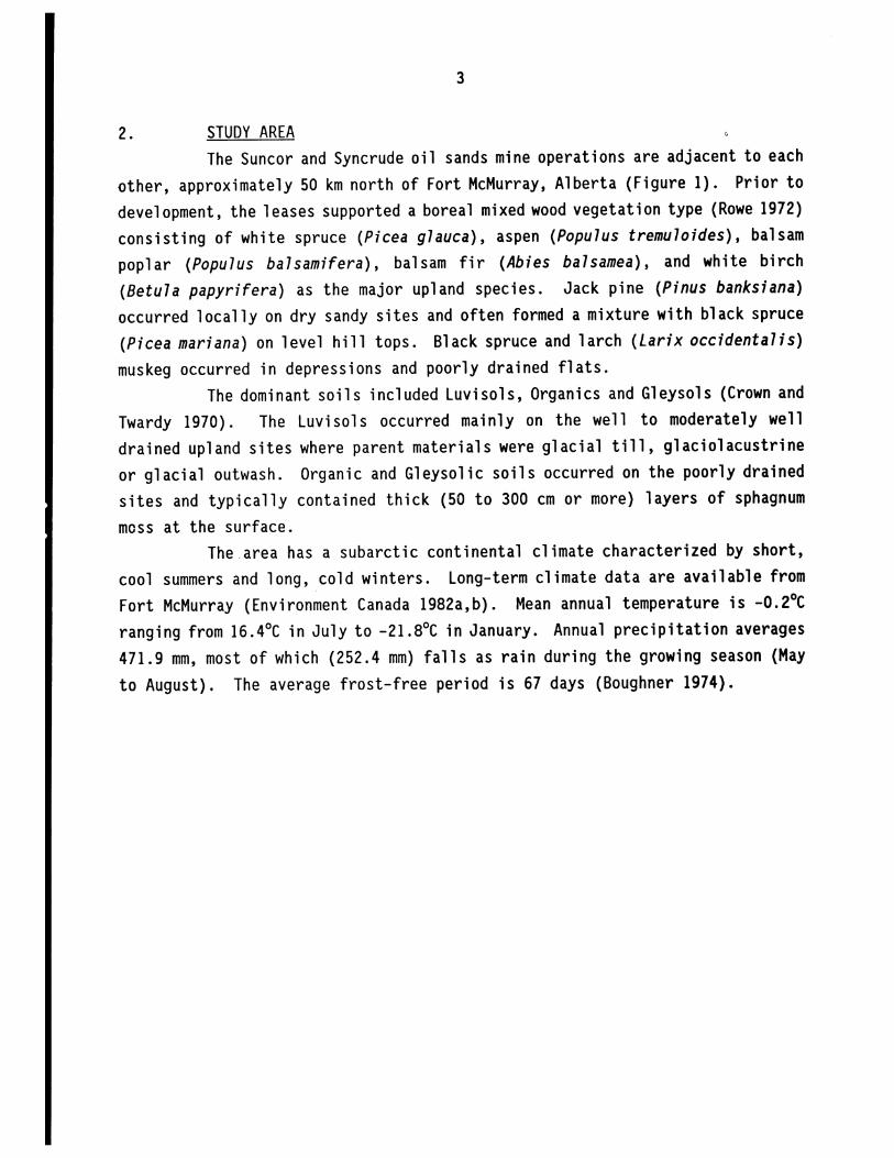
2. STUDY AREA The Sun cor and Syncrude oil sands mine operations are adjacent to each
other, approximately 50 km north of Fort McMurray, Alberta (Figure 1). Prior to development, the leases supported a boreal mixed wood vegetation type (Rowe 1972) consisting of white spruce (Picea glauca) , aspen (Populus tremuloides), balsam poplar (Populus balsamifera), balsam fir (Abies balsamea) , and white birch (Betula papyrifera) as the major upland species. Jack pine (Pinus banksiana) occurred locally on dry sandy sites and often formed a mixture with black spruce (Picea mariana) on level hill tops. Black spruce and larch (Larix occidentalis) muskeg occurred in depressions and poorly drained flats.
The dominant soils included Luvisols, Organics and Gleysols (Crown and Twardy 1970). The Luvisols occurred mainly on the well to moderately well drained upland sites where parent materials were glacial till, glaciolacustrine or glacial outwash. Organic and Gleysolic soils occurred on the poorly drained sites and typically contained thick (50 to 300 cm or more) layers of sphagnum moss at the surface.
The.area has a subarctic continental climate characterized by short, cool summers and long, cold winters. Long-term climate data are available from Fort McMurray (Environment Canada 1982a,b). Mean annual temperature is -0.2°C ranging from 16.4°C in July to -21.8°C in January. Annual precipitation averages 471.9 mm, most of which (252.4 mm) falls as rain during the growing season (May to August). The average frost-free period is 67 days (Boughner 1974).

-- .. - .. ~ ,:: . . I .
:8/ ~/·~ o QI U .0 .c -U)
-.:: ·c CD
4
Northwest Territor
. .
\ "----'..:
c o
. .
-
pt:?1 Subsurface extent :.::::::::: of Oil Sands
... _-- ---~.-United States
Figure 1. Location of the Study Area.
-
5
3. METHODS The data summarized in this report have been gleaned from three main
sources: 1. Sun cor annual reclamation monitoring; 2. Syncrude annual reclamation monitoring; and, 3. RRTAC oil sands soil reconstruction study. Due to differences in reclamation methodology and data collection
among these three areas, they have been dealt with separately in this report. A summary of sites assessed in this study is given in Table 1.
3.1 RECLAMATION Reclamation sites in the oil sands area can be broadly classified into
two main categories: reclaimed tailings sand or reclaimed overburden. Tailings sand is the residual solids component of oil sand following oil extraction. Typically, it is white coloured with a highly uniform sandy texture (approximately 95 percent sand), no coarse fragments, a pH of approximately 8.0, low electrical conductivity (<O.S mS/cm), and very low organic matter and nutrient contents (Monenco Consultants Limited 1983). Due to its highly erodible nature and poor nutrient status, all of the reclaimed sites summarized in this study were amended with a mixture of peat and mineral overburden incorporated into the sand. This contrasts with the current practice of applying these amendments as a capping. As well, all of the reclamation monitoring sites are on slopes seeded to grasses and legumes. The RRTAC oil sands soil reconstruction study plots, located on a level tailings sand pad on the Syncrude Lease, were amended with varying amounts of peat and clay but were not seeded. Amendments were incorporated into the sand.
Overburden is all surface material above the mineable oil sands and is much more variable ranging from heavy clay to gravel or peat. Consequently, reclamation treatment of overburden has also varied. The overburden sites from the Syncrude monitoring program have been described as having heterogeneous "soil" mixes often with clay, gravel, and peat (Langevin and Lulman 1977). All of these sites were seeded to grasses and legumes. The Suncor overburden sites prior to 1979 were reclaimed by incorporating approximately 15 cm of peat into

Table 1. Summary of reclamation sites assessed.
Surfac.e Amendment Revegetation Fert il i zer Number Range in Substrate Location Topography Amendment Mixed In Methods Application of Sites Site Age
(Years) (Years)
Tailings Suncor 40% slopes 15 cm peat Yes Agronomic or 3 to 8 17 1 to 15 Sand or peat- native grasses
overburden and legumes - 1 (up to 40% site seeded to by volume barley only overburden) mixture
Tailings Syncrude 25% slopes 15 cm peat Yes Agronomic 1 8 1 to 10 Sand plus 10 cm grasses and 0'1
overburden legumes
Tailings RRTAC Level 6 to 27 cm Yes None 1 54 2 to 5 Sand Soi 1 peat
Recon- o to 18 cm struction overburden Pad
Over- Suncor 30% slopes 15 cm peat Yes Agronomic 3 15 1 to 10 burden grasses and
legumes
Over- Suncor 30% slopes 15 cm peat No Barley 3 to 5 24 1 to 10 burden
Over- Sync rude Level to None No Agronomic 1 19 1 to 10 burden 40% slopes grasses and
legumes

7
the surface and seed i ng to grasses and 1 egumes. Si nce then, peat has been applied as a 15 to 20 cm cap with minimal incorporation and the areas have been seeded to an annual barley crop in the first year only.
A variety of agronomic as well as native grass and legume seed mixtures have been applied on reclamation sites. Typical mixtures are given in Appendix A. Hydroseeding has been the most common method of seed application. When this method has been used, a mulch and/or tackifier has been included in the slurry along with the seed and often fertilizer as well.
A complete (N-P-K) fertilizer was added to all sites the year they were reclaimed. A typical formulation and rate is 6-24-24 at 350 kg/ha. The Syncrude monitoring sites and the RRTAC soil reconstruction plots received fertilizer the first year only. On the Suncor reclamation sites, maintenance fertilizer was applied annually on all sites until 1979. After this, maintenance fertilizer was only applied for the following two years after reclamation except in specific areas where serious nutrient deficiencies were expected. A typical maintenance application was a 1:1 blend of 27-14-0 and 6-24-0 at 120 kg/ha. In almost all instances, maintenance fertil izer was appl ied by hel icopter broadcast.
3.2 DATA COLLECTION Percentage aerial vegetation cover was assessed on an individual
species basis on all sites. However, plot size and cover categorization varied slightly.
The Suncor reclamation monitoring sites were assessed annually in August by measuring cover along a 30 m transect positioned mid-slope and parallel to the contour on tailings sand dykes or overburden waste dumps. Cover estimates were taken within 10 quadrats (20 cm by 50 cm) placed every 3 m along the transect. Therefore, cover is based on a total of 1 square metre per site. Cover was categorized according to the following scale:
P < 1 percent 4 26 to 50 percent lIto 5 percent 5 51 to 75 percent 2 6 to 15 percent 6 > 75 percent 3 16 to 25 percent
The same quadrat size and cover category scale was used for the RRTAC plots. However, assessment was based on 30 quadrats systematically placed within

8
each 20 m by 40 m plot. This results in a total assessment area of 3 m2 per plot. Plots were assessed in July, two and five years after plot construction.
The Syncrude reclamation monitoring sites measured 4 m by 4 m and vegetation cover was based on the entire area (16 m2). As a result, Syncrude sites tend to have more species with low cover than those at Suncor or the RRTAC plots. As well, the cover category scale was s 1 i ght 1 y different in that categories 2 and 3 were combined (i.e., 6 to 25 percent). Sites were assessed
annually in July or August. In all instances the actual cover percentages used for calculating the
average cover per species per site have been based on the median of each cover categor~ (e.g., 88 percent for Category 6). This results in an underestimate of vegetation cover when an individual species provides a dense cover (e.g., 100 percent cover). However, this rarely occurs for invading species. It is important to note that cover estimates are based on each species in the plot individually and therefore, species overlap can result in some plots having
more than 100 percent total cover.
3.3 DATA ANALYSIS I n an effort to reduce the volume of data co 11 ected from the
monitoring program, changes in cover with time have been based on five year intervals (i.e., 1, 5, 10, and 15 years after reclamation). As well, data from several sites have been omitted to allow for valid comparisons of changes with time of various site groupings. For instance, several monitoring sites were disturbed by operational activities after data had been collected from them for many years. Rather than include data from these sites in the averages for one year, they were omitted so that averages for five or more years would be based
on the same group of sites. Sites seeded to grasses and legumes have had very little invasion of
non-seeded speci es. Consequently, no attempt has been made to statist i cally compare differences in species invasion among sites. As well, no attempt has been made to determine the influence of various site factors (e.g., slope aspect or quality of amendment material) other than separating out reclaimed tailings
sand as opposed to overburden.

9
Rec 1 aimed overburden sites not seeded to grasses and 1 egullles had substantially more cover of invading species. To determine relationships with soil parameters (organic carbon content and bul k density) simple 1 inear regression and correlation analyses were performed for these data. Values for the soil parameters were based on analytical results of samples of the surface amended layer the year the site was reclaimed. Long-term monitoring data from Suncor indicate that organic carbon content does not change with time (Hardy BBT Limi ted 1989a).
The RRTAC soil reconstruction study was designed as a 2 by 3 by 3 factorial experiment corresponding to two depths of amendment mixing (20 cm and 40 cm), three levels of peat application, and three levels of clay overburden application. These data were statistically analyzed by an Analysis of Variance (ANOVA) followed by Duncan's Multiple Range Test to assess differences in cover among treatments.
For all sites, individual species cover percentages and subtotals have been rounded to whole numbers for clarity of presentation. Consequently, subtotal values do not always equal the sum of the individual species values. If a particular species had a cover of less than 0.5 percent, its cover has been expressed as <1.

10
4. RESULTS
4.1 NATURAL INVASION OF SITES SEEDED TO AGRONOMIC GRASSES AND LEGUMES
4.1.1 Reclaimed Tailings Sand The oldest reclaimed sites in the oil sands area are tailings sand
sites on Suncor's Tailings Pond 1 (Tar Island Dyke) reclaimed from 1971 to 1974 and seeded to agronomic grasses and legumes (see Appendix A for seed mixture). Annual monitoring of these sites did not begin until 1977. Another 1 ift of Suncor's Tailing Pond 1 was reclaimed in 1978 and sites on this lift have been monitored annually. The oldest annually monitored sites on tailings sand at Syncrude are also on thei r tail i ngs pond dyke. These sites were seeded to agronomic grasses and legumes in 1978 or 1981. To provide a good sample size for comparison, the Syncrude sites were combined.
Results of natural plant invasion into the areas are summarized in Table 2. A more detailed account of individual species cover is given in Table 3, along with some site description data including the organic carbon content of the surface amended layer measured the year the site was reclaimed.
The most substantial cover of invading species was observed on the oldest (1971) reclaimed sites on Suncor's Tailings Pond 1, where cover increased to an average 21 percent, 15 years after reclamation. However, much less cover was recorded on other 1 ifts of the pond.. The 1974 rec 1 aimed areas had on 1 y 4 percent cover after 15 years and the 1978 reclamation sites had only 1 percent cover after 10 years (Table 2). The greatest cover of natural invaders on the Syncrude Pond sites occurred one year after reclamation averaging 8 percent. This declined to less than 1 percent 10 years later.
As evident in Table 3, cover of natural invading species is highly varia,ble among sites and only a few species persist for many years. The greatest number of speci es was observed on the Syncrude si tes the fi rst year after reclamation. However, 10 of the 14 species recorded had less than 5 percent cover on a particular site. Ten years later, only one of the eight Syncrude sites monitored had any cover of natural invaders and that was a mere 4 percent cover of raspberry. During the same period, cover of seeded species increased from an average of 40 percent in year 1 to 72 percent in year 10. Sow thistle,

Table 2.
Location
Sun cor
Suncor
Suncor
Syncrude
8Symbol s:
11
Total cover of natural invading species on reclaimed tailings sand seeded to agronomic grasses and legumes.
Year Percentage Cover Reclaimed No. Sites Year 18 Year 5 Year 1015 Year 15
1971 5 NO NO 5.7 21.1
1974 4 NO 1.9 0.6 3.9
1978 3 0.2 0.0 1.1 N/A
1978, 1981 8 8.5 2.9 0.4 N/A
NO = No Data; N/A = Not Applicable
bYear 10 data for Syncrude includes data from 5 sites only 8 years old.

Table 3. Percentage cover of natural invading and seeded species on reclaimed tailings sand seeded to agronomic grasses and legumes.
Location Suncor Sun cor Sun cor Syncrude Syncrude Year Reclaimed 1971 1974 1978 1978 1981 Site 1 2 3 4 5 1 2 3 4 1 2 3 1 2 3 1 2 3 4 5 Aspect N E E SE S N E E S E E SE N N N N E S S S Soil Organic Ca (%) 5.4 4.3 8.5 3.6 3.5 3.4 3.4 1.0 1.8 2.9 1.8 3.3 No Data No Data Year 1
Natural Invaders
Sow Thistle 1 1 Hawksbeard 1 Fireweed 1 4 Bindweed 15 Corydalis 1 1 1 Nettle 1 2 2 1 Lamb's Quarter 3 3 Rough Cinquefoil 8 I-'
N
Buttercup 1 Strawberry 6 Hairgrass 7 2 Downy Brome 2 Fringed Brome 2 Redtop 1 2 Horsetail
Subtotal No Data No Data 0 1 1 15 4 25 19 0 2 1 2
Seeded Species
Grasses 8 48 25 45 33 34 14 3 28 16 51 Legumes -1. 22 n. -.1. l§ 11 ~ lQ 24 30 -.1.
Subtotal No Data No Data 17 70 46 47 49 45 14 13 52 46 53
Continued .

Table 3. Continued.
Location Year Reclaimed Site Aspect Soil Organic Ca (%)
Year 5
Natural Invaders
Hawksbeard Yarrow
Subtotal
Seeded Species
Grasses Legumes
Subtotal
Suncor 1971
1 2 3 4 5 NEE SE S
5.4 4.3 8.5 3.6 3.5
No Data
No Data
Suncor 1974
1 234 NEE S
3.4 3.4 1.0 1.8
5 2 <1
5 2 <1 0
46 25 17 30 38 32 36 li
84 57 53 49
Suncor 1978
1 2 3 E E SE
2.9 1.8 3.3
0 0 0
22 39 32 .li -.1. --.2
33 41 37
Syncrude 1978
1 2 3 N N N No Data
1 1I --1
0 17 2
13 22 49 li 39 43
28 61 92
1 N
0
11 99
110
Syncrude 1981
234 E S S No Data
3
3 0 0
17 27 17 34 55 45
51 82 62
5 S
0
33 38
71
Cont i nued . . .
I-' W

Table 3. Continued.
Location Suncor Sun cor Sun cor Sync rude Syncrude Year Reclaimed 1971 1974 1978 1978 1981 Site 1 2 3 4 5 1 2 3 4 1 2 3 1 2 3 1 2 3 4 5 Aspect N E E E SE N E E S E E SE N N N N E S S S Soil Organic Ca (%) 5.4 4.3 8.5 3.6 3.5 3.4 3.4 1.0 1.8 2.9 1.8 3.3 No Data No Data
Year 10
Natural Invaders
Sow Thistle 2 15 10 1 Hawksbeard 1 2 <1 3 Raspberry 4 Fireweed --1 ..... Subtotal 3 16 10 1 0 2 0 <1 0 0 3 0 0 0 0 4 0 0 0 0 ~
Seeded Species
Grasses 71 56 47 36 54 64 27 20 24 30 35 28 35 28 26 5 11 14 24 15 Legumes ~ ~ 11 16 ~ 14 43 43 ~ 38 35 lQ 70 88 75 95 23 li 38 11
Subtotal 71 56 59 52 54 78 70 63 33 68 70 38 105 116 101 100 34 33 62 27
Cont i nued . . .

Table 3. Concluded.
Location Year Reclaimed Site Aspect Soil Organic Ca (%)
Year 15
Natural Invaders
Sow Thistle Hawksbeard Fireweed
Subtotal
Seeded Species
Grasses Legumes
Subtotal
Suncor 1971
12345 NEE E SE
5.4 4.3 8.5 3.6 3.5
9 32 23 18 2 1 11 2 7
-.l
11 34 34 20 7
31 42 43 39 26 3 20 il 18 3
35 62 64 57 30
Suncor 1974
123 4 NEE S
3.4 3.4 1.0 1.8
3 12
0 15 0 0
55 25 61 32 34 55 42 25
89 80 103 57
Sun cor 1978
123 E E SE
2.9 1.8 3.3
Not Applicable
Syncrude 1978
1 2 3 N N N No Data
1 N
Sync rude 1981
234 E S S No Data
Not Applicable
Not Applicable Not Applicable
aOrganic carbon content of the surface amended layer the year the site was reclaimed.
5 S
I-' (.J1
16
hawksbeard and fireweed are the only natural invading species that have been recorded on the Sun cor sites. The relatively low number of species compared to the Syncrude sites is attributed to the larger plot size at Syncrude (16 m2
versus 1 m2). Sow thi stl e is the most abundant speci es, produci ng up to 32 percent cover at one site 15 years after it was reclaimed. This species however, was only abundant at sites on the lower lift and was practically absent from the lifts reclaimed in 1974 and 1978. The major difference among these lifts is the organic content of the surface amended (0 to 15 cm) soil layer. The sites with the greatest cover of invading species (especially sow thistle) also had the highest organic carbon content. Organic C ranged from 3.5 to 8.5 percent on the 1971 lift as opposed to the 1974 and 1978 lifts which ranged from 1.0 to 3.6 percent. There was also a tendency towards greater cover of invading species on north and east slope aspects as opposed to south aspects. The Syncrude year 1 data exemplifies this pattern the most. This trend is also evident for the seeded species.
4.1.2 Reclaimed Overburden Total cover of natural invading species on reclaimed overburden seeded
to agronomic grasses and legumes is summarized in Table 4. Similar to the situation on reclaimed tailings sand, invasion into areas seeded to agronomics is very slow with a maximum average of 6 percent cover observed 10 years after reclamation. At the two locations where natural invaders are present with an average over 1 percent cover, there is an apparent steady trend towards increasing cover of these species with time. At the other two locations, natural invaders have had negligible presence even 10 years after reclamation. Plate 1 (Appendix C) illustrates this. The detailed results of species cover at these sites (Table 5) show that cover is highly variable among sites. This is most apparent for the Syncrude data where almost all of the cover of natural invading species 10 years after reclamation occurred at 2 of the 19 sites (Sites 9 and 19). Similar to the situation on seeded tailings sand, most of the natural invading cover was limited to less than 5 percent cover of a particular species. Sow thistle, fireweed, dandelion, foxtail barley, hairgrass, and willow were the only species producing more than 5 percent cover at a given site.

17
Table 4. Total cover of natural invading species on reclaimed overburden seeded to agronomic grasses and legumes.
Year No. Percentage Cover Location Reclaimed Sites Year 1 Year 5 Year 10
Suncor Dump 5 1976 to 1977 6 0.4 0.0 0.0
Sun cor Dump 7 1976 6 2.5 4.6 6.2
Sun cor Dump 16 1978 3 0.0 0.0 0.0
Syncrude 1976 to 1978 19 1.1 2.2 3.7

Table 5. Percentage cover of natural invading and seeded species on reclaimed overburden seeded to agronomic grasses and legumes.
Locat ion Suncor - Dumg 5 Suncor - Dumg 7 Suncor-Dumg 16 Sync rude Year Rec 1a imed 1976 1977 1976 1978 1976 1977 1978 Site 1 2 3 4 5 6 1 2 3 4 5 6 1 2 3 1 2 3 4 5 6 7 8 9 10 11 12 13 14 15 16 17 18 19 Aspecta 511 SII 511 SII N E E E NE N II II SII SII Nil L E SII L 5 L NE L 511 L SII L L 511 L L L L L
Soi 1 Organic Cb (%) 4.3 4.3 4.3 3.5 3.5 3.5 3.7 3.7 3.7 6.5 6.5 6.5 6.3 6.3 6.3 NDc ND ND ND ND NO ND ND ND NO ND NO NO NO ND NO NO NO NO
Year I"
Natura 1 Invaders
IIi 110w F ireweed Ha i rgrass Lamb's Qua rters IIi 1d Vetch ---.l
Subtota 1 0 a 8 a a a 18
Seeded Sgec ies
Grasses 20 19 19 13 26 22 65 52 55 70 63 65 26 27 46 48 61 113 73 60 76 82 162 57 42 68 78 118 62 44 24 34 18 71 Legumes ...ll ...ll ...ll ...u ..1.l 2f. ---.l .J.§. ..1l!. ~ ..1.l 2Q ..l.!l. ..lll ...ll ---.l ~ ---.l ..M 2Q -E -.f. -.f. ---.l ..lll --..1 ~ ...ll ..J1 ..J.1. .2.Q ~ -1.Q ...lL
Subtota 1 31 33 33 26 47 54 66 90 84 109 84 85 45 45 60 49 104 114 167 110 163 84 164 58 60 11 158 132 74 116 100 89 88 88 t-' CO
Year 5
Natura 1 Invaders
Sow Thistle 15 28 13 Hawksbeard Nett 1e Foxtail Barley 15 IIi 1d Vetch Fireweed Redtop Yarrow Horseta i 1 -2 ---.l Subtota 1 0 0 15 28 0 0 15 0 0 0 16
Seeded Sgec i es
Grasses 58 3 23 40 81 56 89 51 42 56 72 35 25 44 41 106 18 122 117 ;;4 65 101 91 44 32 122 35 48 75 68 5 10 52 8 Legumes .21 ...l ..1l ...lL .£ ~ ---.l .M ..22 .M ..1l ..1.§ ..ll ..1.§ ...J1. ...12 --.l! --..1 J. ~ ---.l --.l! --.l! --.l! ~ ~ 2Q ~ ~ ...2 ~ ..l2 ...J1. ~ Subtota 1 109 54 57 128 111 90 88 98 115 103 61 47 70 68 121 18 125 126 112 66 101 91 44 121 175 65 144 150 120 93 86 79 61
Cont inued ...

Table 5. Concluded.
Locat 10n Suncor - Dump , ___ Suncor - Dump Year Rec la imed 1976 __ I_l7_7 __ 1976 Site 1 2 3 4 5 6 1 2 3 4 5 6 Aspect" SW SW SW SW N E E E NE N W W Soil Organicb (%l 4.3 4.3 4.3 3.5 :.5 3.5 3.7 3.7 3.7 6.5 6.5 6.5
Year 10
Natura 1 1 nvaders
Sow Thist Ie 13 <1 12 <1 Hawksbeard Nett le 4 Wi ld Vetch Fireweed Ha irgrass Wi llow Yarrow Dande 1 ion
Subtota 1 0 0 0 0 13 0 12 8
Seeded Spec i es
Grasses 12 49 37 51 95 46 66 38 67 56 57 54 Legumes ~ ..1Q ~ -.l! ...li £ -2. ..1§ ..1Q .§ J..2 ~
Subtota 1 101 69 77 75 III 88 73 74 87 101 72 60
"t. = Level "Organic carbon content of the surface amended layer the year the site was reclaimed. eND = No Data dYear 1 data for Suncor sites not available by species.
Suncor-Dump 16 1978
1 2 3 SW SW NW 6.3 6.3 6.3
0 0
66 45 74 ..ll ..n -1i
98 70 108
S~ncrude 1976 1977 1978
1 2 3 4 5 6 7 8 9 10 11 12 13 14 15 16 17 18 19 L E SW L S L NE L SW L SW L L SW L L L L L
NDc ND ND ND ND ND ND ND ND ND NO NO ND NO ND NO ND NO ND
3 3 2
22
---l ~
0 0 0 0 31 0 34
49 92 49 91 42 30 59 80 27 10 9 12 76 17 25 2 53 12 7 I-' --2Q ~ --2Q ---ll --2Q -1Q ---ll ---ll --.J! ~ ..'E ill. .2J. ~ .B. ~ ...li ..J.l. ..n ~
109 105 109 91 102 120 59 80 27 105 106 116 129 100 95 95 69 85 40

20
As a result of the very low cover of naturally invading species, it is difficult to recognize any trends in site characteristics that influence this cover. However, the sites on Suncor's Dump 7 that had the greatest cover of naturally invading species had slope aspects ranging from east to north to west. In contrast, most of the sites on Suncor's Dumps 5 and 16 had southwest aspects and almost no cover of natural invaders. A~ mentioned previously, this pattern was also observed on reclaimed tailings sand. The Syncrude sites with the greatest natural species cover generally had the least cover of seeded species. This relationship was not evident among the Suncor sites.
4.2 NATURAL INVASION OF RECLAIMED TAILINGS SAND SEEDED TO NATIVE GRASSES AND LEGUMES Since 1983, Suncor have seeded reclaimed tailings sand slopes to a
mixture of grasses and legumes that naturally occur in the area (Appendix A). Cover of invading species at these sites is summarized in Table 6. For comparison, data are shown from a single site (Site 1 adjacent to Site 2) only seeded to an annual barley crop the first year it was reclaimed.
Cover of natural invading species the first year after reclamation ranged from 0 to 24 percent. Almost all of the variability among sites was due to varying cover of sow thistle, the dominant species. Cover on the site seeded only to barley was comparable in quantity to some of the sites seeded to grasses and legumes but consisted of more species.
The data coll ected fi ve years after recl amat i on ill ustrate that i nvas ion into the nat i ve seeded areas is greater than into those seeded to agronomics, but even greater into the site seeded only to barley. Only two species, sweet clover and alfalfa, had invaded the sites seeded to grasses and legumes, whereas four additional species (sow thistle, fireweed, hawksbeard, and rougn cinquefoil) were found on the site seeded to barley only.
Although there are relatively few sites for comparison, there are no obvious trends of cover with organic carbon content of the surface soil or slope aspect.

Table 6. Percentage cover of natural invading and seeded species on reclaimed tailings sand seeded to native grasses and legumes at Suncor.
Year Reclaimed 1983 1985 1988 Site l a 2 3 46 5 6 7 8 9 Aspect E E SE SE E SE SW SW W Soil Organi c CC (%) 5.9 4.2 3.7 3.8 4.5 4.9 5.2 5.3 5.2
Year 1
Natural Invaders
Sow Thistle 1 1 19 7 17 23 Fireweed 1 1 Hawksbeard 2 2 2 1 Rough Cinquefoil 1 Sweet Clover 2 Lamb's Quarter 1 Sedge 1 Horsetail ~
Subtotal 8 0 0 ND 3 21 10 18 24
Seeded Species
Barley 9 0 0 0 0 0 0 0 0 Grasses N/Ad 26 23 0 28 53 38 34 32 Legumes NLA .Jl 22 .Jl ~ .Jl .Jl .Jl -.lQ
Subtotal 9 26 45 ND 35 53 38 34 48
Continued ...
N ......
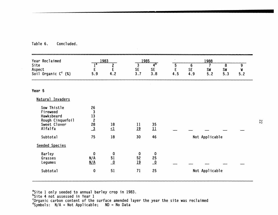
Table 6. Concluded.
Year Reclaimed Site Aspect Soil Organic CC (%)
Year 5
Natural Invaders
Sow Thistle Fireweed Hawksbeard Rough Cinquefoil Sweet Clover Alfalfa
Subtotal
Seeded Species
Barley Grasses Legumes
Subtotal
1983 1985 18 2 3 4D
E E SE SE 5.9 4.2 3.7 3.8
26 3
13 2
28 18 11 35 -.l. <1 12 11
75 18 30 46
0 0 0 0 N/A 51 52 25 fiLA ~ 19 ~
0 51 71 25
8Site 1 only seeded to annual barley crop in 1983. bSite 4 not assessed in Year 1
5 E
4.5
6 SE 4.9
1988 7
SW 5.2
Not Applicable
Not Applicable
cOrganic carbon content of the surface amended layer the year the site was reclaimed dSymbols: N/A = Not Applicable; NO = No Data
8 SW 5.3
9 W
5.2
N N

23
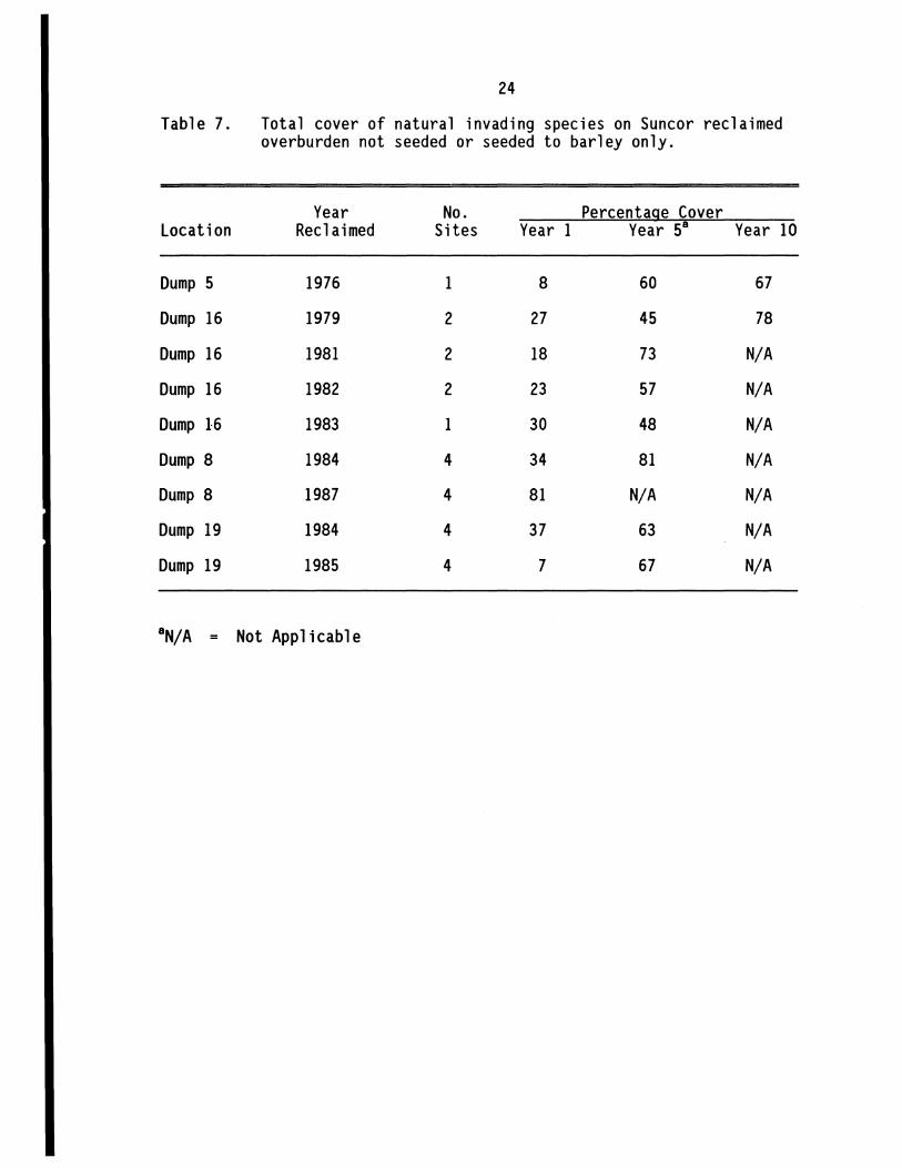
4.3 NATURAL INVASION OF RECLAIMED OVERBURDEN NOT SEEDED OR SEEDED TO BARLEY ONLY Cover of natural invading species on Suncor's reclaimed overburden in
areas not seeded to grasses and legumes is summarized in Table 7. Sites have been grouped according to year of reclamation and dump location so that the source of peat amendment is the same for each group. It is readily apparent that the rate of invasion is much higher into these areas as opposed to those seeded to grasses and legumes. Total cover of all species averaged from 7 to 81 percent only 1 year after reclamation and increased for all groups to an average of 45 to 81 percent after 5 years. Although data are limited for sites 10 years old, these also showed moderate to substantial increases in cover between 5 and 10 years after reclamation.
A detailed breakdown of species cover among these sites along with data on site characteristics is given in Table 8. Similar to other reclaimed areas, the dominant invading species are sow thistle, fireweed, and hawksbeard, especially 1 year after reclamation (Plate 2 Appendix C). Other species that provided substantial cover at some sites include: chickweed, foxtail barley, lamb's quarters, rough cinquefoil, raspberry, sedge, and willow.
Agronomic invading species (i.e., species seeded in surrounding areas) typi cally compri se a very small component of the cover the fi rst year, but increase substantially thereafter, often comprising 50 percent or more of the total cover at some sites 5 and 10 years after reclamation. Sweet clover is by far the dominant agronomic invading species, frequently providing 20 percent cover or more at a particular site. Grasses (fescue and wheatgrasses) were also common invaders but seldom provided more than 10 percent cover at a given site.
The most noteworthy relationship between site factors and cover of invading species is the increase in cover 1 year after reclamation, with increasing organic matter content in the surface soil. This relationship is illustrated in Figure 2 in which vegetation cover is plotted against initial soil organic carbon content along with the Least Squares Regression line. Correlation analysis shows this relationship to be significant (r=0.53, p<O.OI) 1 year after reclamation but there is no relationship (r=O.OO, P>0.50) 5 years after. The optimum organic C content appears to be in the range of 7 to 15 percent. Another soil parameter which varies mainly as a result of the amount of peat used for
24
Table 7. Total cover of natural invading species on Suncor reclaimed overburden not seeded or seeded to barley only.
Year No. Percentage Cover Location Reclaimed Sites Year 1 Year 58 Year 10
Dump 5 1976 1 8 60 67
Dump 16 1979 2 27 45 78
Dump 16 1981 2 18 73 N/A
Dump 16 1982 2 23 57 N/A
Dump 16 1983 1 30 48 N/A
Dump 8 1984 4 34 81 N/A
Dump 8 1987 4 81 N/A N/A
Dump 19 1984 4 37 63 N/A
Dump 19 1985 4 7 67 N/A
8N/A = Not Applicable

Table 8. Percentage cover of invading species on Suncor reclaimed overburden not seeded or seeded to barley only.
Location Dump 5 Dump 16 Dump 8 Dump 19 Year Reclaimed 1976 ~ ~ ..llliiL 1983 1984 1987 1984 1985 Site 1 1 2 3 4 5 6 7 2 3 4 5 6 7 8 2 3 4 5 6 7 8 Aspect SW SW NW SW SW SW SW NW E E E E E E E E NE NE NE NE NW NW SW SW Soil Organic C (%)8 3.5 8.6 8.6 4.9 4.9 4.0 4.0 6.0 15.2 6.4 18.6 13.7 10.0 14.2 13.1 15.6 7.7 7.3 5.59.7 4.1 5.2 3.7 6.3 Soil Bulk Density (g/CC)8 1.0 0.7 0.7 0.9 0.9 0.9 0.9 0.7 0.4 0.8 0.3 0.5 0.9 0.4 0.5 0.4 0.9 0.8 0.9 0.6 1.1 0.8 0.9 0.8
Year 1
Natural Invaders
Chickweed 13 Coltsfoot 4 Coryda 1 is 1 2 Fireweed 22 12 5 4 1 11 39 13 4 18 33 24 6 14 46 39 9 20 10 2 2 Foxtail Barley <1 <1 <1 <1 Hairgrass 1 5 Hawksbeard 3 13 27 2 8 2 <1 12 8 9 9 4 2 2 <1 <1 5 Horsetail 4 <1 Lamb's Quarters 2 29 2 6 Nettle 5 Raspberry 1 Rough Cinquefoil 11 <1 6 4 5 Sedge 2 2 4 3 2 Sow Thistle 5 2 <1 3 13 19 <1 13 39 20 22 2 3 2 2 Unknown 8 4 3 Wi ld Strawberry ~ ...l ...l ...l
Subtotal 8 26 28 12 20 16 31 28 64 36 5 22 74 109 42 51 53 46 11 33 4 10 6 7
Agronomic Invaders
Alsike Clover <1 2 Barley 2 3 3 <1 13 3 6 2 <1 Brame 2 Fescue Sweet Clover 2 4 6 6 4 Wheatgrass ...l ...l ....§ ...z ~
Subtotal 0 <1 0 2 4 0 0 2 4 5 3 <1 14 9 14 11 4 0 0 0 2 <1 0 0
Continued.
N ()1

Table 8. Continued.
Location Dump 5 Dump 16 Dump 8 Dump 19 Year Reclaimed 1976 ..ill.L ~ ~ 1983 1984 1987 1984 1985 Site 1 1 2 3 4 5 6 7 2 3 4 5 6 7 8 2 3 4 5 6 7 8 Aspect SW SW NW SW SW SW SW NW E E E E E E E E NE NE NE NE NW NW SW SW Soil Organic C (%)8 3.5 8.6 8.6 4.9 4.9 4.0 4.0 6.0 15.2 6.4 18.6 13.7 10.0 14.2 13.1 15.6 7.7 7.3 5.59.7 4.1 5.2 3.7 6.3 Soil Bulk Density (g/CC)8 1.0 0.7 0.7 0.9 0.9 0.9 0.9 0.7 0.4 0.8 0.3 0.5 0.9 0.4 0.5 0.4 0.9 0.8 0.9 0.6 1.1 0.8 0.9 0.8
Year 5
Natural Invaders
Dandel ion 1 Fireweed 2 8 5 <1 9 5 8 20 14 3 9 17 10 10 17 18 54 14 22 Foxtail Barley 6 2 9 17 12 9 5 23 1 8 <1 2 12 1 2 2 Goldenrod 4 Hawksbeard <1 2 <1 3 4 6 2 8 2 8 Horsetail 2 Lamb's Quarters 11 Nettle 1 Raspberry 3 12 32 N
Reedgrass 2 ~
Rough Cinquefoil 4 7 10 1 1 1 4 Sedge 2 2 2 2 1 2 1 Sow Thistle 11 11 11 20 8 16 10 26 31 28 25 25 27 17 21 10 10 21 25 Wild Strawberry 7 3 <1 <1 2 2 3 1 3 3 Wi llow <1 6 Yarrow <1 ...1 ...1 ...1 ..1
Subtotal 32 25 30 31 34 28 23 42 113 50 14 47 N/Ab N/A N/A N/A 59 42 50 46 48 66 54 56
Agronomic Invaders
Alsike Clover 1 7 Fescue 2 1 6 6 Sweet Clover 25 24 10 64 20 38 24 6 49 6 9 18 25 18 3 Timothy <1 Wheat grass <1 -1 -1 .2 II 12 ...1 <1 ...1 J -1_ ...1
Subtotal 29 26 10 64 20 38 26 6 2 54 18 24 N/A N/A N/A N/A 19 26 7 6 10 29 1 4
Continued.

Table 8. Concluded.
Location Dump 5 Dump 16 Dump 8 Year Reclaimed 1976 ~ ~ ~ 1983 1984 1987 Site 1 1 2 3 4 5 6 7 2 3 4 5 6 7 8 Aspect SW SW NW SW SW SW SW NW E E E E E E E E Soil Organic C (%)a 3.5 8.6 8.6 4.9 4.9 4.0 4.0 6.0 15.2 6.4 18.6 13.7 10.0 14.2 13.1 15.6 Soil Bulk Density (g/cc)a 1.0 0.7 0.7 0.9 0.9 0.9 0.9 0.7 0.4 0.8 0.3 0.5 0.9 0.4
Year 10
Natural Invaders
Fireweed 3 18 12 Hawksbeard 1 Raspberry 9 6 Rough Cinquefoil 4 Sedge 1 Sow Thistle 11 15 14 Wild Strawberry' 3 2 Wi llow 9 4 Yarrow ..1 ..1
Subtotal 33 50 34 N/A N/A N/A N/A N/A N/A N/A N/A N/A N/A N/A
Agronomic Invaders
Alfalfa 2 4 Brome 5 Crested Wheatgrass 5 Fescue 6 5 Sweet Clover 15 18 46 , Timothy ...l
Subtotal 34 19 55 N/A N/A N/A N/A N/A N/A N/A N/A N/A N/A N/A
-Organic carbon content and bulk density of the surface amended layer the year the site was reclaimed. bN/ A = Not Applicable
0.5 0.4
N/A N/A
N/A N/A
Dump 19 1984 1985
2 3 4 5 6 7 8 NE NE NE NE NW NW SW SW 7.77.35.59.7 4.1 5.2 3.7 6.3 0.9 0.8 0.9 0.6 1.1 0.8 0.9 0.8
N '-J
- - - - - --N/A N/A N/A N/A N/A N/A N/A N/A
- - - - - --N/A N/A N/A N/A N/A N/A N/A N/A

28
YEAR 1
140 Total Vegetation Cover (%)
120 y-3.4x+5.6 *
r-O.53, p<O.01 100
* 80
60
40
20
* 0
0 5 10 15 20 Soil Organic C (%)
YEAR 5 Total Vegetation Cover (%)
120r-------------------------------------------~
100
80
60
40
20
*
* ~ *
** * * * * * *
y-O.01x+65.4 r-O.OO, p>O.50
* * *
*
*
*
OL----------l----------~--------~----------~
o 5 10 15 20 Soil Organic C (%)
Figure 2. Vegetation Cover Versus Soil Organic Carbon Content on Non-seeded Reclaimed Overburden. Soil Organic Carbon Content was Measured in the First Year After Reclamation.

29
amendment is bulk density. With increasing peat content of the surface amended layer, bulk density of this layer decreases. The relationship between vegetation cover and bulk density is illustrated in Figure 3. As bulk density increases (i.e., organic matter decreases) cover of invading species 1 year after reclamation decreases (r=-0.44, p<0.05) but there is no relationship after 5 years.
There are no apparent differences in cover according to slope aspect, although there are relatively few sites available for comparison that were reclaimed the same year and on the same dump.
All three sites that have 10 year data showed increasing cover of invading species from 5 to 10 years. However, increases were small except at one site where cover of sweet clover increased from 10 percent after 5 years to 46 percent after 10 years. Species composition between 5 and 10 years was similar at all sites.
4.4 RRTAC OIL SANDS SOIL RECONSTRUCTION STUDY Cover of the major species invading the RRTAC soil reconstruction
study plots is summarized in Table 9 along with the statistical differences among the main treatment factors under study. Only species that had an overall average cover of 1 percent or more are shown. Agronomic invading species contributed most of the cover, either 2 or 5 years after plot construction. Sweet clover was by far the dominant species at year 2 with an overall cover of 37 percent. Hawksbeard, at only 1 percent cover, was the only species with 1 percent cover or more that has not been seeded in the oil sands area. Alfalfa, wheatgrass and timothy were the other major species at year 2 with cover averaging ~, 4, and 2 percent respectively. Total cover of all species averaged 53 percent. By year 5, species composition of the major invaders showed little change except that sow thistle replaced hawksbeard as the only non-agronomic species with more than 1 percent cover. The most noteworthy change in cover percentage was that sweet clover declined from 37 percent at year 2 to an average 10 percent at year 5. Cover of other species increased, but only slightly so that total cover averaged 36 percent, approximately 17 percent less than that after year 2.
Di fferences wi th respect to treatment were most pronounced after year 2 when cover was significantly greater on the deeper 40 cm amended layer

30
YEAR 1 Total Vegetation Cover (%)
140,-----~------------------------------------~
120 * 100
80
60
40
20
* 0 0.2 0.3 0.4
~
y--S8.4x+ 77.4 r--O.44, p<O.OS
*
* * 0.5 0.6 0.7 0.8 0.9 1.0 1.1
Bulk Density (glee)
YEAR 5
1.2
Total Vegetation Cover (%) 120~----~------------------------------------~ . *
* 100 * *
80 * * *
60 * * 40
* 20
y-O.17x+6S.3 r-O.OO, p>O.SO
* *
OL-__ ~ __ -L __ ~ ____ L-__ ~ __ -L __ ~ ____ L-__ ~ __ ~
0.2 0.3 0.4 0.5 0.6 0.7 0.8 0.9 1.0 1.1 1.2 Bulk Density (glee)
Figure 3. Vegetation Cover Versus Soil Bulk Density on Non-seeded Reclaimed Overburden. Soil Bulk Density was Measured in the First Year After Reclamation.

Table g. Percentage cover of the main invading species on the RRTAC oil sands soil reconstruction study showing statistical differences among treatments.
Mixing Peat Overburden Overall Del2th (D) A12121ication ( P) A12121ication (P)
Species Cover 20 cm 40 cm Low Med High Low Med High
Year 2
Sweet Clover 37 30a 43b 31 a 40b 3gb 21 a 42b 47b Alfalfa 6 r 6a sa r r sa 6a aa Wheatgrass 4 3a 4b la 3b 7c 4a 3a 4a Timothy 2 la 2b l a 2b 3c 2a 2- 2a Hawksbeard 1 l a 2a l a 2a la la la 2b Others ..J. ~ 3a ~ 3a la ~ 2- ...r Subtotal 53 45a 60b 41 a 56b 60b 3r 56b 64c
Year 5
Alfalfa 11 12a lOa 12a lOa 11a loa loa 14-Sweet Clover 10 ga 11a 11a 11a aa 11a loa ga Timothy 4 3a 4a 2a 4b 5c 3a 4a 4a Wheatgrass 4 2a 5b 3a 4a 4a 2a 3b 6c Sow Thistle 4 4a 3a l a 3a 6b 3a 3- 4a Brome 1 la la la la 2a la la 1-Others ..J. ~ ~ 1 3a 4a ~ ~ 3-Subtotal 36 35a 3r 32a 36ab 40b 33a 35- 41 b
Note: For each species and factor, values followed by the same letter are not significantly different from each other at the 95% significance level.
W I--'

32
treatment compared to the 20 cm amended layer and cover increased with appl ication of peat and overburden. Sweet clover's dominance, at year 2 strongly influenced the pattern for total cover, but other species, namely wheatgrass and timothy, increased with amended layer thickness and peat application while hawksbeard increased with overburden application. After year 5 the trends among treatments were still evident (and statistically significant) for peat and overburden application but there was no significant difference in cover between the two amended 1 ayer thi ckness treatments. Pl ates 3 and 4 (Append i x C) illustrate the influence of peat and overburden application on vegetation cover. Sow thistle, timothy, and wheatgrass were the only species with statistically significant differences among treatments.
A detailed breakdown of species cover among all 18 soil treatments is shown in Table 10. At year 2, 16 natural and 11 agronomic species were found on the plots and these numbers were essentially unchanged at year 5. With the exception of hawksbeard and sow thistle, almost all of the natural invading species occurred on several of the treatments but with less than 1 percent cover. The same can be said for the agronomic invading species apart from sweet clover, alfalfa, timothy, and wheatgrass.
The relationship between vegetation cover and organic matter content of the amended (reconstructed) layer is illustrated in Figure 4. Data on natural and agronomic species cover for each of the 18 soil treatments are plotted against initial organic carbon content of the surface (0 to 20 cm) reconstructed 1 ayer along with thei r respect i ve Least Squares Regress ion 1 i nes. At both year 2 and year 5, there is a tendency towards increasing cover of both species groups with i ncreas i ng organ icC content. However, the corre 1 at i on between these factors was significant in only two cases: agronomic invading species in year 2 (r=0.46, p<0.05) and natural invaders in year 5 (r=0.89, p<O.OI). Similarly, the relationship between species cover and initial clay content is shown in Figure 5. Cover of agronomic species increased significantly with clay in year 2 (r=O.72, p<O.OI) and year 5 (r=0.62, p<O.OI) but there was no relationship between cover of natural invaders and clay content at either time.

Table 10. Percentage cover of a 11 i nvadi ng speci es on each treatment of the RRTAC oi 1 sands soil reconstruction plots.
Amended Layer Depth (em) Organic C (%) Clay (%) Bulk Density (glee)
YEAR 2
Natural Invaders
Aster Corydalis Dandelion Fireweed Foxtail Barley Hawksbeard Horsetail Lamb's Quarters Nettle Peppergrass Raspberry Rough Cinquefoil Sedge Smartweed Sow Thistle Yarrow
Subtotal
Agronomic Invaders
Alfalfa Alsike Clover Bluegrass Brome Fescue Red Clover Sweet Clover Redtop Timothy Trefoi 1 Wheatgrass
Subtotal
22 1.1 2.3 1.3
<1
<1
<1
3
<1
<1
6
..1
9
40 1.4 2.7 1.3
<1
<1
<1
<1
2
22 2.0 6.6 1.3
<1
<1 <1 ~
3 . 1
4
<1
<1
15 <1
1 <1 ..1
23
4
29
..1
35
39 23 40 1.7 1.3 1.5 9.9 15.1 13.0 1.3 1.3 1.3
<1
2 <1 <1
<1 1
<1
4
4
<1 <1 <1
52
..1
57
2
<1
<1 <1
3
11
<1
<1
35
<1 <1 ..1
48
<1
<1 1
2
7
<1 <1
49 <1
1
..1
59
22 2.9 2.6 1.3
<1 <1 <1
<1 <1
<1 ~
4
6
<1 1
<1
21
..1
30
41 2.6 2.8 1.2
<1
<1 2
<1 <1
2 <1 ~
5
3
<1 <1
29 <1
1
-2
38
22 2.3 9.3 1.3
<1
<1
4
7 <1 <1 <1 <1
36
..1
46
41 23 41 3.0 2.4 3.3 9.6 11.6 13.8 1.2 1.3 1.1
<1 <1
<1
<1 <1 <1
3
4
<1
54
2 <1 -L
68
<1
2
<1
<1 <1 ~
2
8
<1 1
<1
43
<1 ..1
54
3
<1
<1
<1
3
11
<1 57 <1 3
77
26 4.2 5.0 1.0
<1
<1
4
9
<1 <1 <1
31 <1
3 <1 -2
51
41 3.0 3.1 1.1
<1
<1
<1 <1
4
6
7
<1 1
27
4
47
26 5.0 9.1 0.9
<1
<1 1 ~
3
5
<1 1
<1
37
3
-2
51
40 26 42 3.5 5.0 3.7 7.2 14.7 13.0 1.1 1.0 1.1
<1
<1 <1
2
9
<1 1
<1
44 <1
2
-2
62
<1 <1 <1 <1
2 <1
5
8
<1 <1 <1
35
2 <1
54
<1
2
<1
<1 1
<1
4
3
<1
61
2
-2
73 Continued.
w w

Table 10. Concluded.
Amended Layer Depth (em) Organic C (%) Clay (%)
Z2 1.1 2.3 1.3 Bulk Density (glee)
YEAR 5
Natural invaders
Aster Dande 1 ion Fireweed Foxtail Barley Goldenrod Hawksbeard Horseta i 1 Nettle
<1
<1
Peppergrass <1 Raspberry <1 Rough Cinquefoil <1 Sedge <1 Sloughgrass <1 Sow Thistle <1 Vetch Wild Strawberry <1 Yarrow <1
Subtotal
Agronomic invaders
Alfalfa Alsike Clover Bluegrass Brome Fescue Red Clover Redtop Sweet Clover Timothy Trefoil Wheatgrass
Subtotal
2
5
<1
<1 <1 <1 14 1 2 ~
23
40 1.4 2.7 1.3
<1
<1
<1
<1 <1 <1
2
<1 <1
3
12
<1 <1 <1 8 3
<1 ..1
26
22 2.0 6.6 1.3
<1 <1 <1
<1 <1 <1
1
<1 <1
3
9 <1 <1
1 <1 <1 <1 13
4 1
..1
31
39 1.7 9.9 1.3
<1 <1 <1
<1 <1 <1 <1
1
3
9
<1 <1 <1 <1 11 2
27
23 1.3
15.1 1.3
<1 <1
<1
<1 <1 <1 1
<1 <1
2
20
<1 <1
9 2 1
..1
38
40 1.5
13.0 1.3
<1
<1
<1
<1 <1 3
4
15 <1
1 1
<1 <1 <1
8 2
<1 ...Q
34
22 2.9 2.6 1.3
<1
<1
<1 <1
<1 <1 <1 <1
1
<1 <1
3
10
1 2
<1 <1 <1 10
2 <1 ...1
26
41 2.6 2.8 1.2
<1
<1
<1
<1
<1
3
<1 ~
5
6 <1
1 <1 <1
<1 14 3
<1 ..1
28
22 2.3 9.3 1.3
<1 <1 <1
<1
2 <1 <1
3
12
2 1 1
7 2
<1 ...1
25
41 23 3.0 2.4 9.6 11.6 1.2 1.3
<1 1
<1
<1 <1
<1
5
<1
7
6 <1 <1 2
13 5
<1 ..2
33
<1 <1 <1
<1
<1
2
<1 ~
3
16 <1
1 1 1
<1 <1 11 5 1
--1
39
41 3.3
13.8 1.1
<1
<1
<1
<1
2
4
12 <1
2 2
<1 <1 11
5
41
26 4.2 5.0 1.0
<1
<1 <1
9
10
17 <1
1 1
<1 <1
4 6 2
..1
33
41 3.0 3.1 1.1
<1 <1
1
<1
<1 <1
4
<1
6
9 <1 <1
1 <1 <1
13 6 1
..1
33
Note: All soil characteristics based on sampling the surface (0 to 20 em) reconstructed layer following plot construction.
26 5.0 9.1 0.9
<1
<1
7
<1
9
10
<1 1
<1 <1
6 6 2
..1
29
40 3.5 7.2 1.1
<1 2
<1
<1
<1 4
7
12 <1
1 3
<1 <1
8 3
<1 --1
31
26 5.0
14.7 1.0
<1 <1
1
<1
<1
9
10
11 <1 1
<1
<1
4 4 3
.2
28
42 3.7
13.0 1.1
<1
<1
<1
<1 <1
5 <1 <1 ~
6
8
1 3
<1 1
12 7
<1 ~
39

35
YEAR 2 Vegetation Cover (%)
80.----------------------------------------------,
60 ** *
* 40
*
* 20
*
* *
*
* *
*
* * *
y"O.36x+2.3 r'"O.34, p>O.05
o~==~~~~~~~c=~==~====~ o 1 234
Soil Organic C (%)
YEAR 5
5 6
Vegetation Cover (%) 80~---------------------------------------------~
60
y-O.61x+29.6
40 * * * *
r-O.14x, p>O.25
* * "" * "" * * * * * * 20 y=2.0x-O.61
r-O.89, p<O.01 + ...I-
:b
0' -r -1-+ -rr + +
0 1 2 3 4 5 6 SOil Organic C (%)
1- Legend
~ral """"*- Agronomic
Figure 4. Vegetation Cover Versus Soil Organic Carbon Content on the RRTAC Soil Reconstruction Study Plots. Soil Organic Carbon Content was Measured Following Plot Construction.
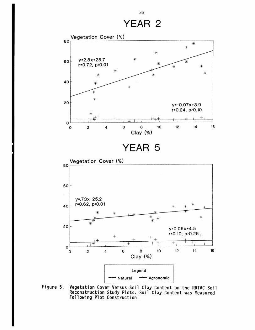
36
YEAR 2 ~v~e~g~e~ta=t~io~n~C~o~v~e~r_(~~~o)~ _____________________ ~ ____ ,
80 *
60
40
20
y·2.8x+25.7 r·O.72, p<O.01
*
-f'-
*
*
* *
*
*
y·-O.07x+3.9 r a O.24, p>O.10
*
oL-__ ~~ __ -L ____ J-~L-L-__ ~ ____ ~ __ ~-L __ ___
o 2 4 6 8 10 12 14 16 Clay (%)
YEAR 5 Vegetation Cover (%)
80
60
40
20
o o
y·.73x+25.2 r=O.62, p<O.01
* ""'-
**
+ +"*'
2 4
* ""'-
,/ '/
* **
+ ++ + + +-+:-
6 8 10 Clay (%)
Legend
* +- *'
* y=O.06x+4.5 r=O.10, p>O.25 +
-L_
+ -t +
12 14
-+-- Natural ~ Agronomic
*-
+ 16
Figure 5. Vegetation Cover Versus Soil Clay Content on the RRTAC Soil Reconstruction Study Plots. Soil Clay Content was Measured Following Plot Construction.

37
5. DISCUSSION Seeding reclamation areas to agronomic grasses and legumes is clearly
the major factor that inhibits natural species invasion. The rate of invasion on these seeded sites is minimal even after 10 to 15 years and relatively unaffected by duration of fertil izer appl ication or whether the site is reclaimed tailings sand or overburden. This reclamation technique provides maximum protection from erosion but the vegetation that develops also strongly hinders establishment of planted trees and shrubs. Consequently, this practice has been discontinued at both Suncor and Syncrude.
Seeding reclaimed tailings sand to a mixture of native grasses and legumes (tested at Sun cor only) appears to allow slightly more rapid invasion but the dominant invading species have been agronomics (sweet clover and alfalfa) that were seeded in other reclamation areas. Therefore, the major advantage of this method is that the vegetation cover that develops is less competitive with planted trees and shrubs while still providing protection from erosion.
Depending on site conditions, a dense vegetation cover can be established quickly on either tailings sand or overburden without the need of seeding grasses and legumes. The site factor that appears to have the greatest i nfl uence on rate of i nvas ion is the organi c matter content of the surface amended layer. Sites with the greatest cover of invading species, especially the first year after reclamation, generally have an organic C content in the range of 7 to 15 percent. In the oil sands reclamation programs, the two factors that i nfl uence organ i c matter content in the surface 1 ayer are the peat/mi nera 1 overburden ratio of the amendment material and the degree of incorporation of this material into the underlying substrate (tailings sand or overburden). Both Syncrude and Suncor currently use a capping method with minimal or ·no i ncorporat ion. The capp i ng approach has 1 ed to an increase in the rate of invasion compared to incorporating amendments into the substrates, the method used at both mi nes sites duri ng the early years of recl amat ion. The major difference between the capping methods is that Suncor applies approximately 20 cm of material with a relatively high peat content (50 to 75 percent by volume) compared to Syncrude's technique of a 70 cm capping of material that typically contains higher proportions of mineral overburden. The Suncor method probably

38
promotes more rapid invasion due to the tendency of a higher organic content of the surface.
The influence of peat content on the rate of invasion is attributed to two factors. The peat improves moisture conditions for germination at the surface and it acts as a source of propagules. The relative importance of these two factors is d i ffi cult to assess but cons i deri ng the weedy nature of the dominant invading species and their ability to quickly invade a particular site, it is conceivable that the propagules introduced with the peat plays a minor role.
Slopes with south aspects generally have slower species invasion than those with north aspects. This likely reflects the poorer surface moisture conditions for seed germination. It is on these slopes where increased organic matter content in the amendment 1 ayer woul d be most important to increase moisture content and hence natural invasion.
The dominant invading species the year after reclamation are those native to the area but within five years of reclamation agronomic grasses and legumes generally take over. This is especially true for reclaimed tailings sand. Sweet clover is by far the dominant agronomic invading species and appears to pers i st for many years on both rec 1 aimed tail i ngs sand and overburden. Desirable characteristics of this species include high drought tolerance, moderate. palatability, high erosion control ability and its potential for building up soil organic matter content (Hardy BBT Limited 1989b). In the oil sands area it is well suited for reclamation of dry south-facing slopes. The only native species that produced significant cover and persisted for several years were sow thistle, fireweed and hawksbeard. Of these native herbs, sow thistle and fireweed are the most significant due to their tall (up to 2 m) growth habit and extens i ve root systems that ass i st in eros i on control and organic matter build up. Fireweed has moderate palatability (Hardy BBT Limited 1989b) but generally these species likely have low wildlife value.
Perhaps of most importance is the relative absence of native trees and shrubs recorded. The data reviewed in this report slightly underestimate their abundance because species that are commonly planted were not included. These include: pine, spruce, aspen, poplar, larch, dogwood, serviceberry, and silverberry. However, even if these were included, their cover would have been

39
minimal. Places where these species provide substantial cover as a result of natural invasion include seepage zones, where willow can form dense stands, and peat disposal areas where aspen and poplar are common. Steve Tuttle (land Reclamation Coordinator, Suncor Inc., Fort McMurray, Alberta; telephone call 1989) has noticed enhanced natural invasion of aspen when reclaiming overburden sites using a capping of in-situ peat with relatively low mineral material. In this situation, root fragments in the peat are the most 1 ikely source of propagules.
As a result of the low invasion of trees and shrubs, extensive planting programs are necessary at Syncrude and Suncor to meet their reclamation goals. The major obstacle to the success of these planted species has been the difficulty in establ ishing seedl ings in the areas seeded to agronomic grasses and legumes. The poor establishment has been attributed to competition as well as damage by small mammals. These adverse effects are reduced when the vegetation cover consists of native forbs and consequently both operators have discontinued seeding with agronomics.
Natural invasion has produced adequate cover to control erosion of rec 1 aimed overburden on slopes and 1 eve 1 areas. However, Syncrude has had significant erosion on reclaimed tailings sand slopes that were not seeded and Suncor will experiment with non-seeded tailings sand slopes for the first time in 1990. Data from the RRTAC soil reconstruction study indicate that increasing the peat content of the surface layer will lead to enhanced growth of natural invading species as well as planted trees and shrubs (Hardy BBT limited 1990). Erosion was not a problem on any of the RRTAC plots. Therefore, reclamation efforts on level areas should be directed towards enhanced growth of planted species. However, reclamation of tailings sand slopes must address erosion control as well as performance of planted species. It is in these reclamation areas that invasion of native species will play an important role in controlling erosion while allowing establishment of planted species to form the woody component of the desired vegetation communities.

40
6. CONCLUSIONS AND RECOMMENDATIONS 1. Natural invasion into reclaimed areas seeded to agronomic grasses
and legumes is minimal even after 15 years. 2. The rate of natural i nvas i on into seeded areas is the same for
reclaimed tailings sand and reclaimed overburden and is unaffected by duration of fertilizer application.
3. Natural invasion into reclaimed tailings sand seeded to native grasses and legumes is sl ight1y faster than areas seeded to agronomics.
4. Natural invasion is greatest into reclaimed areas not seeded or only seeded to an annual barley crop.
5. Organic matter content of the surface amended layer is the most important site factor affecting the rate of native species invasion with the optimum having between 7 and 15 percent organic C content.
6. The rate of invasion is faster on northerly slope aspects as opposed to southerly aspects.
7. Agronomic species are the dominant invaders into non-seeded reclaimed areas and sweet clover is the major agronomic invader.
S. The major native invading species are sow thistle, fireweed and hawksbeard and these are the only species that produce significant cover for several years. These species are beneficial in terms of their ability to control erosion and to increase soil organic matter content, but they have minimal value for wil d1 He.
9. There is minimal invasion of trees and shrubs within 10 to 15 years irrespective of reclamation treatment or site factors.
10. Planting programs are necessary to introduce woody species at adequate stocking densities into most reclaimed areas.
11. Reclamation of tailings sand slopes should place more emphasis on methods to increase invasion of native species (e.g., ensure a high proportion of peat is in the surface soil layer), whereas reclamation of level areas should be more concerned with enhanced performance of planted species.

41
12. Factors that appear to influence the rate of native woody species invasion should be investigated, especially on tailings sand slopes. Important factors include: peat content of the surface soils, in-situ versus stockpiled peat, and application of the amendment as a capping as opposed to incorporating the amendment into the sand.

42
7. LITERATURE CITED
Boughner, C.C., 1974. The distribution of growing-degree days in Canada. Ottawa, Department of Transport. Canadian Meteorological Memoirs No. 17. 40 pp.
Crown, P.H. and A.G. Twardy, 1970. Soils for the Fort McMurray Region, Alberta, and their relation to agriculture and urban development. Alberta Institute of Pedology, University of Alberta Contribution M-70-Z. 52 pp.
Environment Canada, 1982a. Canadian Climate Normals Volume 2. Temperature 1951-1980. 602 pp.
Environment Canada, 1982b. Canadian Climate Normals Volume 3. Precipitation 1951-1980. 602 pp.
Hardy BBT Limited, 1989a. Reclamation trend analysis for vegetation and soil characteristics in reclaimed areas on the Suncor Lease. Prepared by Hardy BBT Limited, Calgary, Alberta for Suncor Inc., Oil Sands Group, Fort McMurray, Alberta. 47 pp.
Hardy BBT Limited, 1989b. Manual of plant species suitability for reclamation in Alberta - 2nd Edition. Alberta Land Conservation and Reclamation Council Report # RRTAC 89-4. 436 pp.
Hardy BBT Limited, 1990. Oil sands soil reconstruction project - annual report 1989/90. Unpublished report prepared by Hardy BBT Limited, Calgary, Alberta for Alberta Land Conservation and Reclamation Council. 47 pp.
Langevin, A. and P.O. Lulman, 1977. Revegetation Activities - 1976. Syncrude Canada Ltd. 54 pp.
Monenco Consultants Limited, 1983. Soil reconstruction design for the reclamation of oilsands tailings. Alberta Land Conservation and Reclamation Council Report # RRTAC 83-1. 185 pp.
Rowe, J.S., 1972. Forest regions of Canada. Department of the Environment. Canadian Forestry Service. Publication Number 1300. Ottawa. 172 pp.
43
APPENDIX A
TYPICAL SEED MIXTURES APPLIED
TO RECLAMATION SITES

44
Syncrude - Steep Slopes - Dry (South Facing Well Drained)
Species
Smooth Bromegrass Slender Wheatgrass Crested Wheatgrass Hard Fescue Canada Bluegrass Timothy Alfalfa Red Clover Alsike Clover
(Bromus i nermi s) (Agropyron trachycaulum) (Agropyron cristatum) (Festuca ovina) (Poa compressa) (Phleum pratense) (Medicago sativa) (Trifolium pratense) (Trifolium hybridum)
Syncrude - Steep Slopes - Moist to Wet
Species
Streambank Wheatgrass Russian Wild-Rye Smooth Bromegrass Meadow Foxtail Creeping Red Fescue Timothy Alfalfa Bird's-Foot Trefoil Sweet Clover
Species
Smooth Bromegrass Slender Wheatgrass Pubescent Wheatgrass Timothy Creeping Red Fescue Sanfoin Bird's-Foot Trefoil Alfalfa Sweet Clover
(Agropyron riparium) (Elymus junceus) (Bromus inermis) (Alopecurus pratensis) (Festuca rubra) (Phleum pratense) (Medicago sativa) (Lotus corniculatus) (Melilotus alba & M. officinalis)
Syncrude - Level Ground - Moist
(Bromus inermis) (Agropyron trachycaulum) (Agropyron trichophorum) (Phleum pratense) (Festuca rubra) (Onobrychis viciaefolia) (Lotus corniculatus) (Medicago sativa) (Melilotus alba & M. officinalis)
Percent by Weight
20 15 10 15 10 5
10 10 5
Percent by Weight
20 15 10 10 5 5
15 15 5
Percent by Weight
20 20 15 10 5
10 10 5 5

45
Suncor Tailings Sand Slopes (1971 to 1975)
Species
Smooth Bromegrass Crested Wheatgrass Creeping Red Fescue Alfalfa Alsike Clover Sweet Clover
(Bromus inermis) (Agropyron cristatum) (Festuca rubra) (Medicago sativa) (Trifo7ium hybridum) (Me7i7otus a7ba & M. officina7is)
Suncor - Overburden Slopes (Prior to 1979)
Species
Smooth Bromegrass Crested Wheatgrass Slender Wheatgrass Creeping Red Fescue Sweet Clover Alsike Clover Alfalfa
(Bromus inermis) (Agropyron cristatum) (Agropyron trachycau7um) (Festuca rubra) (Me7i7otus a7ba & M. officina7is) (Trifo7ium hybridum) (Medicago sativa)
Sun cor - Tailings Sand Slopes (Since 1983)
Species
Violet Wheatgrass Sheep Fescue Hairgrass Fowl Bluegrass Redtop Kentucky Bluegrass Meadow Foxtail Alsike Clover
(Agropyron vio7aceum) (Festuca ovina) (Agrostis scabra) (Poa pa7ustris) (Agrostis a7ba) (Poa pratensis) (A7opecurus pratensis) (Trifo7ium hybridum)
Percent by Weight
30 27 17 10 8 8
Percent by Weight
20 17 17 6
17 13 10
Percent by Weight
48 10 9 9 5 5 9 5

46

47
APPENDIX B
LIST OF COMMON AND SCIENTIFIC NAMES

48
LIST OF COMMON AND SCIENTIFIC NAMES
Common Name
Alfalfa Alsike clover Aster Barley Bindweed Bluegrass Brome Buttercup Chickweed Coltsfoot Corydalis Crested wheatgrass Dandelion Downy brome Fescue Fireweed Foxtail barley Fringed brome Goldenrod Hairgrass Hawksbeard Horsetail Lamb's quarters Nettle Peppergrass Raspberry Red clover Redtop Reedgrass Rough cinquefoil Sedge Sloughgrass Smartweed Sow thistle Sweet clover Timothy Trefoi 1 Wheatgrass Wil d strawberry Wild vetch Wi 11 ow Yarrow
Scientific Name
Medicago sativa Trifolium hybridum Aster spp. Hordeum spp. Polygonum convulvulus Poa spp. Bromus spp. Ranunculus spp. Cerastium arvense Petasites spp. Coryda 7i s aurea Agropyron cristatum Taraxacum spp. Bromus tectorum Festuca spp. Epilobium angustifolium Hordeum jubatum Bromus ciliatus Solidago spp. Agrostis scabra Crepi s tectorum Equisetum spp. Chenopodium album Urtica gracilis Lepidium spp. Rubus spp. Trifolium pratense Agrosti sal ba Calamagrostis spp. Potentilla norvegica Carex spp. Beckmannia syzigachne Polygonum spp. Sonchus arvensis Mel ilotus spp. Phleum pratense Lotus corniculatus Agropyron spp. Fragaria spp. Vicia spp. Salix spp. Achillea millefo7ium

49
APPENDIX C
PHOTOGRAPHS
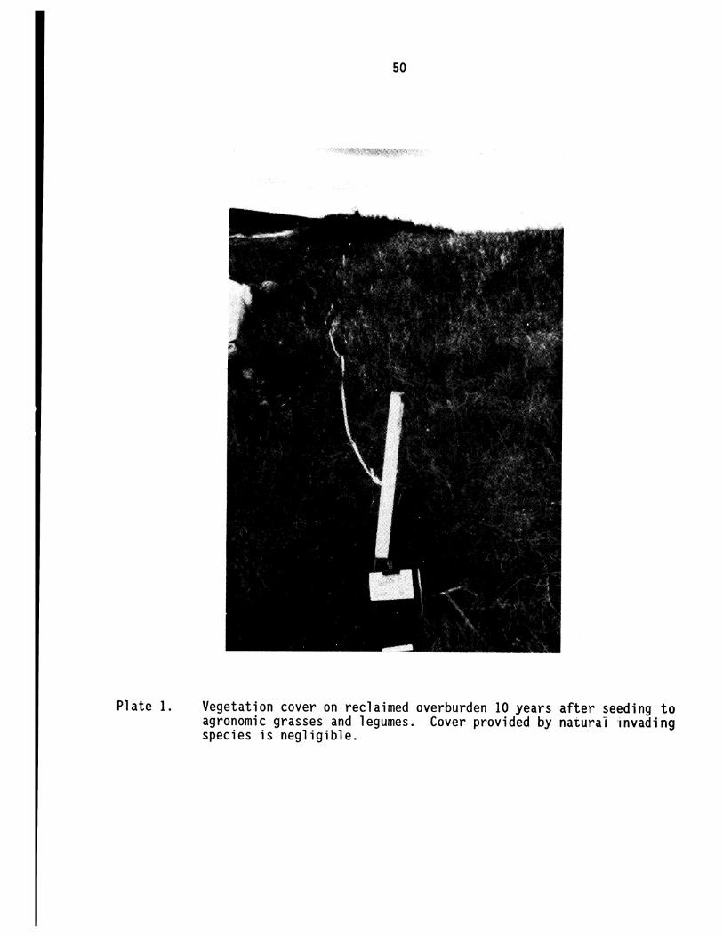
Plate 1.
50
Vegetation cover on reclaimed overburden 10 years after seeding to agronomic grasses and legumes. Cover provided by naturai 'invading species is negligible.

Plate 2.
51
Vegetation cover on reclaimed overburden 1 year after seeding to an annual barley. Note the dense cover of natural invading species dominated by sow thistle, fireweed, and hawksbeard.

Plate 3.
52
Sparse vegetation cover at year 5 on an RRTAC plot that received a low application rate of peat and mineral overburden.

Plate 4.
53
Dense vegetation cover at year 5 on an RRTAC plot that received a high application rate of peat and mineral overburden.

54

55
APPENDIX D
RECLAMATION RESEARCH REPORTS
56
RECLAMATION RESEARCH REPORTS
1. RRTAC 79-2: Proceedings: Workshop on Native Shrubs in Reclamation. P.F. Ziemkiewicz, C.A. Dermott and H.P. Sims (Editors). 104 pp. No longer available.
The Workshop was organized as the fIrst step in developing a Native Shrub reclamation research program. The Workshop provided a forum for the exchange of information and experiences on three topics: propagation; outplanting; and, species selection. Seven papers and the results of three discussion groups are presented.
2. RRTAC 80-1: Test Plot Establishment: Native Grasses for Reclamation. R.S. Sadasivaiah and J. Weijer. 19 pp. No longer available.
The report details the species used at three test plots in Alberta's Eastern Slopes (one at Caw Creek Ridge and two at Cadomin). Site preparation, experimental design, and planting method are also described.
3. RRTAC 80-3: The Role of Organic Compounds in Salinization of Plains Coal Mining Sites. N.S.C. Cameron et al. 46 pp. $10.00
This is a literature review of the chemistry of sodic mine spoil and the changes expected to occur in groundwater.
4. RRTAC 80-4: Proceedings: Workshop on Reconstruction of Forest Soils in Reclamation. P.F. Ziemkiewicz, S.K. Takyi and H.F. Regier (Editors). 160 pp. $10.00.
Experts in the fIeld of forestry and forest soils report on research relevant to forest soil reconstruction and discuss the most effective means of re~toring forestry capability of mined lands.
5. RRTAC 80-5: Manual of Plant Species Suitability for Reclamation in Alberta. L.E. Watson, R.W. Parker and D.F. Polster. 2 vols, 541 pp. No longer available; replaced by RRTAC89-4.
Forty-three grass, fourteen forb, and thirty-four shrub and tree species are assessed in terms of their suitability for use in reclamation. Range maps, growth habit, propagation, tolerance, and availability information are provided.
6. RRTAC 81-2: 1980 Survey of Reclamation Activities in Alberta. D.G. Walker and R.L. Rothwell. 76 pp. $10.00
This survey is an update of a report prepared in 1976 on reclamation activities in Alberta, and includes research and operational reclamation, locations, personnel, etc.
7. RRTAC 81-3: Proceedings: Workshop on Coal Ash and Reclamation. P.F. Ziemkiewicz, R. Stein, R. Leitch and G. Lutwick (Editors). 253 pp. $10.00
Presents nine technical papers on the chemical, physical, and engineering properties of Alberta fly and bottom ashes, revegetation of ash disposal sites, and use of ash as a soil amendment. Workshop discussions and summaries are also included.

57
8. RRTAC 82-1: Land Surface Reclamation: An International Bibliography. H.P. Sims and C.B. Powter. 2 vols,292 pp. $10.00
Literature to 1980 pertinent to reclamation in Alberta is listed in Vol. 1 and is also on the University of Alberta computing system (in a SPIRES database called RECLAIM). Vol. 2 comprises the keyword index and computer access manual.
9. RRTAC 82-2: A Bibliography of Baseline Studies in Alberta: Soils, Geology, Hydrology and Groundwater. C.B. Powter and H.P. Sims. 97 pp. $5.00
This bibliography provides baseline information for persons involved in reclamation research or in the preparation of environmental impact assessments. Materials, up to date as of December 1981, are available in the Alberta Environment Library.
10. RRTAC 83-1: Soii Reconstruction Design for Reclamation of Oil Sand Tailings. Monenco Consultants Ltd. 185 pp. No longer available
Volumes of peat and clay required to amend oil sand tailings were estimated based on existing literature. Separate soil prescriptions were made for spruce, jack pine, and herbaceous cover types. The estimates form the basis of field trials.
11. RRTAC 83-3: Evaluation of Pipeline Reclamation Practices on Agricultural Lands in Alberta. Hardy Associates (1978) Ltd. 205 pp. No longer available.
Available information on pipeline reclamation practices was reviewed. A field survey was then conducted to determine the effects of pipe size, age, soil type, construction method, etc. on resulting crop production.
12. RRTAC 83-4: Proceedings: Effects of Coal Mining on Eastern Slopes Hydrology. P.F. Ziemkiewicz (Editor). 123 pp. $10.00
Technical papers are presented dealing with the impacts of mining on mountain watersheds, their flow characteristics, and resulting water quality. Mitigative measures and priorities were also discussed.
13. RRTAC 83-5: Woody Plant Establishment and Management for Oil Sands Mine Reclamation. Techman Engineering Ltd. 124 pp. No longer available.
This is a review and analysis of information on planting stock quality, rearing techniques, site preparation, planting, and procedures necessary to ensure survival of trees and shrubs in oil sand reclamation.
14. RRTAC 84-1: Land Surface Reclamation: A Review of the International Uterature. H.P. Sims, C.B. Powter and J.A. Campbell. 2 vols, 1549 pp. $20.00
Nearly all topics of interest to reclamationists including mining ~ethods, soil amendments, revegetation, propagation and toxic materials are reviewed in light of the intemationalliterature.
15. RRTAC 84-2: Propagation Study: Use of Trees and Shrubs for Oil Sand Reclamation. Techman Engineering Ltd. 58 pp. $10.00
This report evaluates and summarizes all available published and unpublished informati~n on large-scale propagation methods for shrubs and trees to be used in oil sand reclamation.

58
16. RRTAC 84·3: Reclamation Research Annual Report ·1983. P.F. Ziemkiewicz. 42 pp. $5.00
This report details the Reclamation Research Program indicating priorities, descriptions of each research project, researchers, results, and expenditures.
17. RRTAC 84-4: Soil Microbiology in Land Reclamation. D. Parkinson, R.M. Danielson, C. Griffiths, S. Visser and J.C. Zak. 2 vols, 676 pp. $10.00
This is a collection of five reports dealing with re-establishment of fungal decomposers and mycorrhizal symbionts in various amended spoil types.
18. RRTAC 85·1: Proceedings: Revegetation Methods for Alberta's Mountains and Foothills. P.F. Ziemkiewicz (Editor). 416 pp. $10.00
Results of long-term experiments and field experience on species selection, fertilization, reforestation, topsoiling, shrub propagation and establishment are presented.
19. RRTAC 85·2: Reclamation Research Annual Report· 1984. P.F. Ziemkiewicz. 29 pp. $5.00
This report details the Reclamation Research Program indicating priorities, descriptions of each research project, researchers, results, and expenditures.
20. RRTAC 86·1: A Critical Analysis of Settling Pond Design and Alternative Technologies. A. Somani. 372 pp. $10.00
The report examines the critical issue of settling pond design, and sizing and alternative technologies. The study was co-funded with The Coal Association of Canada.
21. RRTAC 86·2: Characterization and Variability of Soil Reconstructed after Surface Mining in Central Alberta. T.M. Macyk. 146 pp. No longer available.
Reconstructed soils representing different materials handling and replacement techniques were characterized, and variability in chemical and physical properties was assessed. The data obtained indicate that reconstructed soil properties are determined largely by parent material characteristics and further tempered by materials handling procedures. Mining tends to create a relatively homogeneous soil landscape in contrast to the mixture of diverse soils found before mining.
22. RRTAC 86·3: Generalized Procedures for Assessing Post·Mining Groundwater Supply Potential in the Plains of Alberta· Plains Hydrology and Reclamation Project. M.R. Trudell and S.R. Moran. 30 pp. $5.00
In the Plains region of Alberta, the surface mining of coal generally occurs in rural, agricultural areas in which domestic water supply requirements are met almost entirely by groundwater. Consequently, an important aspect of the capability of reclaimed lands to satisfy the needs of a residential component is the post-mining availability of groundwater. This report proposes a sequence of steps or procedures to identify and characterize potential post-mining aquifers.
23. RRTAC 86-4: Geology of the Battle River Site: Plains Hydrology and Reclamation Project. A. Maslowski·Schutze, R. U, M. Fenton and S.R. Moran. 86 pp. $10.00
This report summarizes the geological setting of the Battle River study site. It is designed to provide a general understanding of geological conditions adequate to establish a framework for hydrogeological and general reclamation studies. The report is not intended to be a detailed synthesis such as would be required for mine planning purposes.
59
24. RRTAC 86-5: Chemical and Mineralogical Properties of Overburden: Plains Hydrology and Reclamation Project. A. Maslowski-Schulze. 71 pp. $10.00
This report describes the physical and mineralogical properties of overburden materials in an effort to identify individual beds within the bedrock overburden that might be significantly different in terms of reclamation potential.
25. RRTAC 86-6: Post-Mining Groundwater Supply at the Battle River Site: Plains Hydrology and Reclamation Project. M.R. Trudell, G..J. Sterenberg and S.R. Moran. 49 pp. $5.00
The report deals with the availability of water supply in or beneath cast overburden to support post-mining land use, including both quantity and quality considerations. The study area is in the Battle River Mining area in east -central Alberta.
26. RRTAC 86-7: Post-Mining Groundwater Supply at the Higbvale Site: Plains Hydrology and Reclamation Project. M.R. Trudell. 25 pp. $5.00
This report evaluates the availability of water supply in or beneath cast overburden to support post-mining land use, including both quantity and quality considerations. The study area is the Highvale mining area in west-central Alberta.
27. RRTAC 86-8: Reclamation Research Annual Report· 1985. P.F. Ziemkiewicz. 54 pp. $5.00
This report details the Reclamation Research Program indicating priorities, descriptions of each research project, researchers, results, and expenditures.
28. RRTAC 86-9: Wildlife Habitat Requirements and Reclamation Techniques for the Mountains and Foothills of Alberta. J.E. Green, R.E. Salter and D.G. Walker. 285 pp. No longer available.
This report presents a review of relevant North American literature on wildlife habitats in mountain and foothills biomes, reclamation techniques, potential problems in wildlife habitat reclamation, and potential habitat assessment methodologies. Four biomes (Alpine, Subalpine, Montane, and Boreal Uplands) and 10 key wildlife species (snowshoe hare, beaver, muskrat, elk, moose, caribou, mountain goat, bighorn sheep, spruce grouse, and white-tailed ptarmigan) are discusse& The study was co-funded with The Coal Association of Canada.
29. RRTAC 87-1: Disposal of Drilling Wastes. LA. Leskiw, E. Reinl.Dwyer, T.L Dabrowski, Bol. Rutherford and H. Hamilton. 210 pp. No longer available.
Current drilling waste disposal practices are reviewed and criteria in Alberta guidelines are assessed. The report also identifies research needs and indicates mitigation measures. A manual provides a decision-making flowchart to assist in selecting methods of environmentally safe waste disposal.
30. RRTAC 87·2: Minesoil and Landscape Reclamation of the Coal Mines in Alberta's Mountains and Foothills. A.W. Fedkenheuer, L..J. Knapik and D.G. Walker. 174 pp. $10.00
This report reviews current reclamation practices with regard to site and soil reconstruction and re-establishment of biological productivity. It also identifies research needs in the Mountain·Foothills area. The study was co-funded with The Coal Association of Canada.
31. RRTAC 87·3: Gel and Saline Drilling Wastes in Alberta: Workshop Proceedings. D.A. lloyd (Compiler). 218 pp. No longer available.
Technical papers were presented which describe: mud systems used and their purpose; industrial constraints; government regulations, procedures and concerns; environmental considerations in waste disposal; and toxic constituents of drilling wastes. Answers to a questionnaire distributed to participants are included in an appendix.

60
32. RRTAC 87-4: Reclamation Research Annual Report -1986. 50 pp. $5.00
This report details the Reclamation Research Program indicating priorities, descriptions of each research project, researchers, results, and expenditures.
33. RRTAC 87-5: Review orthe Scientific Basis of Water Quality Criteria for the East Slope Foothills of Alberta. Beak Associates Consulting Ltd. 46 pp. $10.00
The report reviews existing Alberta guidelines to assess the quality of water drained from coal mine sites in the East Slope Foothills of Alberta. World literature was reviewed within the context of the East Slopes environment and current mining operations. The ability of coal mine operators to meet the various guidelines is discussed. The study was co-funded with The Coal Association of Canada.
34. RRTAC 87-6: Assessing Design Flows and Sediment Discharge on the Eastern Slopes. Hydrocon Engineering (Continental) Ltd. and Monenco Consultants Ltd. 97 pp. $10.00
The report provides an evaluation of current methodologies used to determine sediment yields due to rainfall events in well-defmed areas. Models are available in Alberta to evaluate water and sediment discharge in a post-mining situation. SEDIMOT II (Sedimentology Disturbed Modelling Techniques) is a single storm model that was developed specifically for the design of sediment control structures in watersheds disturbed by surface mining and is well suited to Alberta conditions. The study was co-funded with The Coal Association of Canada.
35. RRTAC 87-7: The Use of Bottom Ash as an Amendment to Sodic Spoil. S. Fullerton. 83 pp. No longer available.
The report details the use of bottom ash as an amendment to sodic coal mine spoil. Several rates and methods of application of bottom ash to sodic spoil were tested to determine which was the best at reducing the effects of excess sodium and promoting crop growth. Field trials were set up near the Vesta mine in East Central Alberta using ash readily available from a nearby coal-frred thermal generating station. The research indicated that bottom ash incorporated to a depth of 30 cm using a subsoiler provided the best results.
36. RRTAC 87-8: Waste Dump Design for Erosion Control. R.G. Chopiuk and S.E. Thornton. 45 pp. $5.00
This report describes a study to evaluate the potential influence of erosion from reclaimed waste dumps on downslope environments such as streams and rivers. Sites were selected from coal mines in Alberta's mountains and foothills, and included resloped dumps of different configurations and ages, and having different vegetation covers. The study concluded that the average annual amount of surface erosion is minimal. As expected, erosion was greatest on slopes which were newly regraded. Slopes with dense grass cover showed no signs of erosion. Generally, the amount of erosion decreased with time, as a result of initial loss of fme particles, the formation of a weathered surface, and increased vegetative cover.
37. RRTAC 87-9: Hydrogeology and Groundwater Chemistry of the Battle River Mining Area. M.R. Trudell, R.L. Faught and S.R. Moran. 97 pp. No longer available.
This report describes the premining geologic conditions in the Battle River coal mining area including the geology as well as the groundwater flow patterns, and the groundwater quality of a sequence of several water-bearing formations extending from the surface to a depth of about 100 metres.
61
38. RRTAC 87-10: Soil Survey of the Plains Hydrology and Reclamation Project - Battle River Project Area. T.M. Macyk and A.H. MacLean. 61 pp. plus 8 maps. $10.00
The report evaluates the capability of post-mining landscapes and assesses the changes in capability as a result of mining, in the Battle River mining area. Detailed soils information is provided in the report for lands adjacent to areas already mined as well as for lands that are destined to be mined. Characterization of the reconstructed soils in the reclaimed areas is also provided. Data were collected from 1979 to 1985. Eight maps supplement the report.
39. RRTAC 87-11: Geology of the Highvale Study Site: Plains Hydrology and Reclamation Project. A. Maslowski-Schulze. 78 pp. $10.00
The report is one of a series that describes the geology, soils and groundwater conditions at the Highvale Coal Mine study site. The purpose of the study was to establish a summary of site geology to a level of detail necessary to provide a framework for studies of hydrogeology and reclamation.
40. RRTAC 87-12: Premining Groundwater Conditions at the Highvale Site. M.R. Trudell and R. Faught. 83 pp. $10.00
This report presents a detailed discussion of the premining flow patterns, hydraulic properties, and isotopic and hydrochemical characteristics of five layers within the Paskapoo Geological Formation, the underlying sandstone beds of the Upper Horseshoe Canyon Formation, and the surficial glacial drift.
41. RRTAC 87-13: An Agricultural Capability Rating System for Reconstructed Soils. T.M. Macyk. 27 pp. $5.00
This report provides the rationale and a system for assessing the agricultural capability of reconstructed soils. Data on the properties of the soils used in this report are provided in RRTAC 86-2.
42. RRTAC 88-1: A Proposed Evaluation System for Wildlife Habitat Reclamation in the Mountains and Foothills Biomes of Alberta: Proposed Methodology and Assessment Handbook. T.R. Eccles, R.E. Salter and J.E. Green. 101 pp. plus appendix. $10.00
The report focuses on the development of guidelines and procedures for the assessment of reclaimed wildlife habitat in the Mountains and Foothills regions of Alberta. The technical section provides background documentation including a discussion of reclamation planning, a listing of reclamation habitats and associated key wildlife species, conditions required for development, recommended revegetation species, suitable reclamation techniques, a description of the recommended assessment techniques and a glossary of basic terminology. The assessment handbook section contains basic information necessary for evaluating wildlife habitat reclamation, including assessment scoresheets for 15 different reclamation habitats, standard methodologies for measuring habitat variables used as assessment criteria, and minimum requirements for certification. This handbook is intended as a field manual that could potentially be used by site operators and reclamation officers. The study was co-funded with The Coal Association of Canada.
43. RRTAC 88-2: Plains Hydrology and Reclamation Project: Spoil Groundwater Chemistry and its Impacts on Surface Water. M.R. Trudell (Compiler). 135 pp. $10.00
Two reports comprise this volume. The first "Chemistry of Groundwater in Mine Spoil, Central Alberta," describes the chemical make-up of spoil groundwater at four mines in the Plains of Alberta. It explains the nature and magnitude of changes in groundwater chemistry following mining and reclamation. The second report, "Impacts of Surface Mining on Chemical Quality of Streams in the Battle River Mining Area," describes the chemical quality of water in streams in the Battle River mining area, and the potential impact of groundwater discharge from surface mines on these streams.
62
44. RRTAC 88-3: Revegetation or Oil Sands Tailings: Growth Improvement or Silver-berry and Buffalo-berry by Inoculation with Mycorrhizal Fungi and N2-Fixing Bacteria. S. Visser and R.M. Danielson. 98 pp. $10.00 .
The report provides results of a study: (1) To determine the mycorrhizal affinities of various actinorrhizal shrubs in the Fort McMurray, Alberta region; (2) To establish a basis for justifying symbiont inoculation of buffalo-berry and silver-berry; (3) To develop a growing regime for the greenhouse production of mycorrhizal, nodulated silver-berry and buffalo-berry; and, (4) To conduct a field trial on reconstructed soil on the Syncrude Canada Limited oil sands site to critically evaluate the growth performance of inoculated silver-berry and buffalo-berry as compared with their un-inoculated counterparts.
45. RRTAC 88-4: Plains Hydrology and Reclamation Project: Investigation orthe Settlement Behaviour or Mine Backfill. D.R. Pauls (compiler). 135 pp. $10.00
This three part volume covers the laboratory assessment of the potential for subsidence in reclaimed landscapes. The first report in this volume, ·Simulation of Mine Spoil Subsidence by Consolidation Tests, • covers laboratory simulations of the subsidence process particularly as it is influenced by resaturation of mine spoil. The second report, "Water Sensitivity of Smectitic Overburden: Plains Region of Alberta, " describes a series of laboratory tests to determine the behaviour of overburden materials when brought into contact with water. The report entitled "Classification System for Transitional Materials: Plains Region of Alberta," describes a lithological classification system developed to address the characteristics of the smectite rich, clayey transition materials that make up the overburden in the Plains of Alberta.
46. RRTAC 88-5: Ectomycorrhizae or Jack Pine and Green Alder: Assessment or the Need for Inoculation, Development or Inoculation Techniques and Outplanting Trials on Oil Sand Tailings. R.M. Danielson and S. Visser. 177 pp. $10.00
The overall objective of this research was to characterize the mycorrhizal status of Jack Pine and Green Alder which are prime candidates as reclamation species for oil sand tailings and to determine the potential benefits of mycorrhizae on plant performance. This entailed determining the symbiont status of container-grown nursery stock and the quantity and quality of inoculum in reconstructed soils, developing inoculation techniques and finally, performance testing in an actual reclamation setting.
47. RRTAC 88-6: Reclamation Research Annual Report ·1987. Reclamation Research Technical Advisory Committee. 67 pp. No longer available.
This annual report describes the expenditure of $500,000.00 of Alberta Heritage Savings Trust Fund monies on research under the Land Reclamation Program. The report outlines the objectives and research strategies of the four program areas, and describes the projects funded under each program..
48. RRTAC 88-7: Baseline Growth Performance Levels and Assessment Procedure ror Commercial Tree Species in Alberta's Mountains and Foothills. W.R. Dempster and Associates Ltd. 66 pp. $5.00
Data on juvenile height development of lodgepole pine and white spruce from cut-over or burned sites in the Eastern Slopes of Alberta were used to derme reasonable expectations of early growth performance as a basis for evaluating the success of reforestation following coal mining. Equations were developed predicting total seedling height and current annual height increment as a function of age and elevation. Procedures are described for applying the equations, with further adjustments for drainage class and aspect, to develop local growth performance against these expectations. The study was co-funded with The Coal Association of Canada.

63
49. RRTAC 88·8: Alberta Forest Service Watershed Management Field and Laboratory Methods. A.M.K. Nip and K.A. Hursey. 4 Sections, various paglngs. $10.00
Disturbances such as coal mines in the Eastern Slopes of Alberta have the potential for affecting watershed quality during and following mining. The collection of hydrometric, water quality and • hydrometeorologic information is a complex task. A variety of instruments and measurement methods are required to produce a record of hydrologic inputs and outputs for a watershed basin. There is a growing awareness and recognition that standardization of data acquisition methods is required to ensure data comparability, and to allow comparison of data analyses. The purpose of this manual is to assist those involved in the field of data acquisition by outlining methods, practices and instruments which are reliable and recognized by the International Organization for Standardization.
SO. RRTAC 88·9: Computer Analysis of the Fadors Inftuenclng Groundwater Flow and Mass Transport in a System Disturbed by Strip Mining. F.W. Schwartz and A.S. Crowe. 78 pp. $10.00
Work presented in this report demonstrates how a groundwater flow model can be used to study a variety of mining· related problems such as declining water levels in areas around the mine as a result of dewatering, and the development of high water tables in spoil once resaturation is complete. This report investigates the role of various hydrogeological parameters that influence ~e magnitude, timing, and extent of water level changes during and following mining at the regional scale. The modelling approach described here represents a major advance on existing work.
51. RRTAC 88·10: Review of Literature Related to Clay Liners for Sump Disposal of Drilling Wastes. D.R. Pauls, S.R. Moran and T. Macyk. 61 pp. $5.00
The report reviews and analyses the effectiveness of geological containment of drilling waste in sumps. Of particular importance was the determination of changes in properties of clay materials as a result of contact with highly saline brines containing various organic chemicals.
52. RRTAC 88·11: Highvale Soil Reconstruction Project: Five Year Summary. D.N. Graveland, T.A. Oddie, A.E. Osborne and LA. Panek. 104 pp. $10.00
This report provides details of a five year study to determine a suitable thickness of subsoil to replace over minespoil in the Highvale plains coal mine area to ensure return of agricultural capability. The study also examined the effect of slope and aspect on agricultural capability. This study was funded and managed with industry assistance.
53. RRTAC 88·12: A Review ofthe International Literature on Mine Spoil Subsidence. J.D. Scott, G. Zinter, D.R. Pauls and M.B. Dusseault. 36 pp. $10.00
The report reviews available engineering literature relative to subsidence of reclaimed mine spoil. The report covers methods for site investigation, field monitoring programs and lab programs, mechanisms of settlement, and remedial measures.
54. RRTAC 89·1: Reclamation Research Annual Report ·1988. 74 pp. $5.00
This annual report describes the expenditure of S280,OOO.OO of Alberta Heritage Savings Trust Fund monies on research under the Land Reclamation Program. The report outlines the objectives and research strategies of the four program areas, and describes the projects funded under ~ach program.

64
55. RRTAC 89-2: Proceedings of the Conference: Reclamation, A Global Perspective. D.G. Walker, C.B. Powter and M.W. Pole (Compilers). 2 Vols., 854 pp. $10.00
Over 250 delegates from all over the world attended this conference held in Calgary in August, 1989. The proceedings contains over 85 peer-reviewed papers under the following headings: A Global Perspective; Northern and High Altitude Reclamation; Fish & Wildlife and Rangeland Reclamation; Water; Herbaceous Revegetation; Woody Plant Revegetation and Succession; Industrial and Urban Sites; Problems and Solutions; Sodic and Saline Materials; Soils and Overburden; Acid Generating Materials; and, Mine Tailings.
56. RRTAC 89-3: Efficiency of Activated Charcoal for Inactivation of Bromacil and Tebuthiuron Residues in Soil. M.P. Sharma. 38 pp. $5.00
Bromacil and Tebuthiuron were commonly used soil sterilants on well sites, battery sites and other industrial sites in Alberta where total vegetation control was desired. Activated charcoal was found to be effective in binding the sterilants in greenhouse trials. The influence of factors such as herbicide:charcoal concentration ratio, soil texture, organic matter content, soil moisture, and the time interval between charcoal incorporation and plant establishment were evaluated in the greenhouse.
57. RRTAC 89-4: Manual of Plant Species Suitability for Reclamation in Alberta - 2nd Edition. Hardy BBT Limited. 436 pp. $10.00
This is an updated version ofRRTAC Report 80-5 which describes the characteristics of 43 grass, 14 forb and 34 shrub and tree species which make them suitable for reclamation in Alberta. The report has been updated in several important ways: a line drawing of each species has been added; the range maps for each species have been redrawn based on an ecosystem classification of the province; new information (to 1990) has been added, particularly in the sections on reclamation use; and the material has been reorganized to facilitate information retrieval. Of greatest interest is the performance chart that precedes each species and the combined performance charts for the grass, forb, and shrub/tree groups. These allow the reader to pick out at a glance species that may suit their particular needs. The report was produced with the assistance of a grant from the Recreation, Parks and Wildlife Foundation.
58. RRTAC 89-5: Battle River Soil Reconstruction Project Five Year Summary. L.A. Leskiw. 188 pp. $10.00
This report summarizes the results of a five year study to investigate methods required to return capability to land surface mined for coal in the Battle River area of central Alberta. Studies were conducted on: the amounts of subsoil required, the potential of gypsum and bottom ash to amend adverse soil properties, and the effects of slope angle and aspect. Forage and cereal crop growth was evaluated, as were changes in soil chemistry, density and moisture holding characteristics.
59. RRTAC 89-6: Detailed Sampling, Characterization and Greenhouse Pot Trials Relative to Drilling Wastes in Alberta. T.M. Macyk, F.I. Nikiforuk, S.A. Abboud and Z.W. Widtman. 228 pp. $10.00
This report summarizes a three-year study of the chemistry of freshwater gel, KCI, NaCI, DAP, and invert drilling wastes, both solids and liquids, from three regions in Alberta: Cold Lake, Eastern Slopes, and Peace River/Grande Prairie. A greenhouse study also examined the effects of adding various amounts of waste to soil on grass growth and soil chemistry. Methods for sampling drilling wastes are recommended.
60. RRTAC 89-7: A User's Guide for the Prediction of Post-Mining Groundwater Chemistry from Overburden Characteristics. M.R. Trudell and D.C. Cheel. 55 pp. $5.00
This report provides the detailed procedure and methodology that is required to produce a prediction of post-mining groundwater chemistry for plains coal mines, based on the soluble salt characteristics of overburden materials. The fundamental component of the prediction procedure is the geochemical model PHREEQE, developed by the U.S. Geological Survey, which is in the public domain and has been adapted for use on personal computers.

65
61. RRTAC 90-1: Reclamation Research Annual Report -1989. 62 pp. $5.00
This annual report describes the expenditure of $480,000.00 of Alberta Heritage Savings Trust Fund monies on research under the Land Reclamation Program. The report outlines the objectives and research strategies of the four program areas, and describes the projects funded under each program.
62. RRTAC 90-2: Initial Selection for Salt Tolerance in Rocky Mountain Accessions of Slender Wheatgrass and Alpine Bluegrass. R. Hennesh, J. Woosaree, B.A. Darroch, S.N. Acharya and A. Smreciu. 40 pp. $5.00
Selected lines of slender wheatgrass and alpine bluegrass collected from alpine and subalpine regions of Alberta as part of another native grass project were evaluated for their ability to emerge in a saline medium. Eleven slender wheatgrass and 72 alpine bluegrass lines had a higher percentage emergence than the Orbit Tall Wheatgrass control (a commonly available commercial grass). This means that as well as an ability to grow in high elevation areas, these lines may also be suitable for use in areas where saline soil conditions are present. Thus, their usefulness for reclamation has expanded.

This material is provided under educational reproduction permissions included in Alberta Environment and Sustainable Resource Development's Copyright and Disclosure Statement, see terms at http://www.environment.alberta.ca/copyright.html. This Statement requires the following identification: "The source of the materials is Alberta Environment and Sustainable Resource Development http://www.environment.gov.ab.ca/. The use of these materials by the end user is done without any affiliation with or endorsement by the Government of Alberta. Reliance upon the end user's use of these materials is at the risk of the end user.


![TAR-SANDS (ARENAS BITUMINOSAS) [OIL-SANDS]](https://img.dokumen.tips/doc/110x75/546e6d60b4af9faa268b468b/tar-sands-arenas-bituminosas-oil-sands.jpg)