Embed Size (px)
Citation preview

PUBLIC DISCLOSURE AUTHORISED
CARIBBEAN DEVELOPMENT BANK
TWO HUNDRED AND SIXTY-SECOND MEETING OF THE BOARD OF DIRECTORS
TO BE HELD IN BARBADOS
JULY 17, 2014
PAPER BD 50/14
NATURAL DISASTER MANAGEMENT - REHABILITATION AND RECONSTRUCTION
(DECEMBER 2013 TROUGH EVENT) – ST. VINCENT AND THE GRENADINES
(President’s Recommendation No. 883) 1. The attached Staff Report appraises a proposal for a loan to the Government of St. Vincent and the
Grenadines (GOSVG). The expected outcome of the Project is improved Windward and Vigie Highway
corridors and enhanced institutional capacity for planning, design and risk reduction. This is to be achieved
through the restoration and rehabilitation of bridges and damaged sections of the feeder road network, and
the Windward and Vigie Highways, and the rehabilitation of river defences along the Yarabaqua and
Caratal rivers.
2. On the basis of the Report, I recommend:
(a) a loan to GOSVG of an amount not exceeding the equivalent of nine million, and forty-six
thousand United States dollars (USD9.046 mn) representing 80% of the project cost,
consisting of:
(i) an amount from the Ordinary Capital Resources of the Caribbean Development
Bank (CDB), not exceeding USD5.529 mn; and
(ii) an amount from CDB’s Special Funds Resources (SFR) not exceeding USD3.517
mn; and
(b) a grant to GOSVG of an amount not exceeding USD221,000 from CDB’s SFR for use by
GOSVG in financing the cost of equipment for rainfall and stream flow measurement, and
training of hydrological technicians;
on the terms and conditions set out and referred to in Chapter 6 of the Report.
3. Funds are available within CDB’s existing resources and/or borrowing programme for the relevant
disbursement period.

PUBLIC DISCLOSURE AUTHORISED
CARIBBEAN DEVELOPMENT BANK
STAFF REPORT
ON
NATURAL DISASTER MANAGEMENT REHABILITATION AND RECONSTRUCTION
(DECEMBER 2013 TROUGH EVENT)
ST. VINCENT AND THE GRENADINES
Considered at the Two Hundred and Sixty-Second Meeting of
the Board of Directors on July 17, 2014.
(BD50/14)
Officer-in-Charge - Deidre Clarendon
Projects Department
Division Chief - Andrew Dupigny
Economic Infrastructure Division
JULY 2014
This Document is being made publicly available in accordance with the
Bank’s Information Disclosure Policy. The Bank does not accept
responsibility for the accuracy or completeness of the Document.

Any designation or demarcation of, or reference to, a particular territory or geographic area in this Document
is not intended to imply any opinion or judgment on the part of the Bank as to the legal or other status of any
territory or area or as to the delimitation of frontiers or boundaries.
This Report was prepared by a Team comprising:
Merlyn Combie, Operations Officer/Coordinator; Anne Marie Chandler, Operations Officer (Social Analyst); Leah Bobb-
Semple, Legal Counsel; Patrick Kendall, Consultant Economist; Yuri Chakalall, Disaster Risk Management Specialist;
Albert Gillings, Operations Officer (Civil Engineer); and Karene Daniel, Coordinating Secretary.

AO - Administrative/Accounting Officer
BMCs - Borrowing Member Countries
BRAGSA - Roads, Building and General Services
CC - Climate Change
CCRIF - Caribbean Catastrophic Risk Insurance Facility
CDB - Caribbean Development Bank
CIMH - Caribbean Institute for Meteorology and Hydrology
CPA - Country Poverty Assessment
CWSA - Central Water and Sewerage Authority
DDMC - District Disaster Management Committee
DiMSOG - Disaster Management Strategy and Operational Guidelines
DRM - Disaster Risk Management
DRR - Disaster Risk Reduction
EMMP - Environmental Management and Mon
ERG - Emergency Relief Grant
EU - European Union
GDP - Gross Domestic Product
GGLA - Government Guarantee of Loan Act
GOSVG - Government of St. Vincent and the G
IDC - Interest During Construction
IMF - International Monetary Fund
IRL - Immediate Response Loan
ISP - Implementation Support Plan
mn - million
MTW - Ministry of Transport and Works
NCB - National Competitive Bidding
NDC - National Disaster Coordinator
NEC - National Emergency Council
NEDM - National Emergency and Disaster Management
NEEC - National Emergency Executive Committee
NEMO - National Emergency Management Organisation
NPDP - National Physical Development Plan
OCR - Ordinary Capital Resources
OIE - Office of Independent Evaluation
p.a. - per annum
PBL - Policy Based Loan
PC - Project Coordinator
PE - Project Engineer
PLW - Project Launch Workshop
PMD - Project Management Division
CURRENCY EQUIVALENT
Dollars ($) throughout refer to Eastern Caribbean Dollars (XCD) unless otherwise stated.
USD1.00 = XCD2.70
XCD1.00 = USD0.37
ABBREVIATIONS
Authority

PMH - Project Manager Hydrology
PPES - Project Performance Evaluation System
PT - Project Team
SFR - Special Funds Resources
SVG - St. Vincent and the Grenadines
TA - Technical Assistance
TOR - Terms of Reference
UOF - Use of Funds
USD - United States Dollars
WB - World Bank
(ii)
MEASURES AND EQUIVALENTS
1 hectare (ha)
1 kilometre (km)
=
=
2.47 acres
0.621 mile (mi)
1 square kilometre (km2) = 0.386 square mile (mi2)
1 metre (m) = 3.281 feet (ft)
1 millimetre (mm)
1 square metre (m2)
= =
0.039 inch (in)
10.756 square feet (ft2)

TABLE OF CONTENTS
COUNTRY DATA: ST. VINCENT AND THE GRENADINES
LOAN AND PROJECT SUMMARY
1. INTRODUCTION
2. THE PROJECT
3. RISK ASSESSMENT AND MITIGATION
4. THE BORROWER AND EXECUTING AGENCY
5. JUSTIFICATION AND BENEFITS
6. TERMS AND CONDITIONS
APPENDICES
1.1
1.2 1.3
2.1 2.2
2.3
2.4
2.5 2.6 2.7 2.8 2.9 2.10 2.11
2.12
2.13 2.14 4.1
SUMMARY OF DAMAGE AND LOSSES CAUSED BY DECEMBER 2013
TROUGH EVENT
SOCIAL AND GENDER CONTEXT
SUMMARY OF PREVIOUS CDB-FUNDED DISASTER MANAGEMENT
PROJECTS IN ST. VINCENT AND THE GRENADINES, 1986-2013
DETAILS OF THE PROJECT
DRAFT TERMS OF REFERENCE - TECHNICAL ASSISTANCE FOR
TRAINING OF TECHNICIANS IN HYDROLOGY TO USE, MANAGE AND
MAINTAIN ST. VINCENT AND THE GRENADINES’ NATIONAL
NETWORK OF RAINFALL AND RIVER FLOW MONITORING STATIONS
DRAFT TERMS OF REFERENCE – CONSULTANCY SERVICES FOR A
REHABILITATION AND UPGRADE STUDY FOR VIGIE HIGHWAY AND
ASSOCIATED BRIDGES
DRAFT TERMS OF REFERENCE – CONSULTANCY SERVICES TO
UNDERTAKE LANDSLIDE RISK ASSESSMENT, SLOPE STABILISATION
AND REMEDIAL DESIGN STUDY FOR ST. VINCENT’S NORTH
WINDWARD HIGHWAY CORRIDOR
PROJECT COST, FINANCING AND PHASING PLAN
DRAFT PROJECT IMPLEMENTATION SCHEDULE
IMPLEMENTATION SUPPORT PLAN
ESTIMATED QUARTERLY DISBURSEMENT SCHEDULE
PROJECT MANAGEMENT ORGANISATIONAL CHART
DRAFT TERMS OF REFERENCE - PROJECT TEAM
DRAFT TERMS OF REFERENCE - CONSULTING ENGINEERING
SERVICES FOR DESIGN REVIEW AND CONSTRUCTION SUPERVISION -
IMMEDIATE MITIGATION WORKS
DRAFT TERMS OF REFERENCE - CONSULTING ENGINEERING
SERVICES FOR DESIGN REVIEW AND CONSTRUCTION SUPERVISION -
INFRASTRUCTURE REHABILITATION AND UPGRADE
PROCUREMENT PLAN
REPORTING REQUIREMENTS
THE EXECUTING AGENCY FOR THE GRANT
FIGURE
1. PROJECT LOCATION MAP

COUNTRY DATA: ST. VINCENT AND THE GRENADINES
2009 2010 2011 2012 2013 PER CAPITA GDP (current market prices; $) 18,187 18,143 17,853 18,135 18,764
GROSS DOMESTIC PRODUCT (GDP) GDP at Current Market Prices ($mn)
Demand Components:
Consumption Expenditure
1,822.3
1,912.2
1,839.7
1,931.9
1,828.1
1,911.0
1,875.0
2,009.0
1,959.4
2,017.4
Gross Domestic Investment 438.6 464.0 440.4 443.1 519.8
Exports of Goods and Non-factor Services 519.2 494.6 493.6 508.6 526.0
Imports of Goods and Non-factor Services 1,047.7 1,050.8 1,016.9 1,085.7 1,103.8
Gross Domestic Savings Ratio (4.9) (5.0) (4.5) (7.1) (3.0)
Sectoral distribution of current GDP (%) Agriculture 6.6 6.7 6.4 7.2 5.8
Mining & Quarrying 0.3 0.3 0.3 0.2 0.2
Manufacturing 5.5 5.7 5.9 6.5 4.5
Utilities 4.6 4.4 4.2 4.9 4.1
Construction 9.6 9.1 9.3 8.3 9.2
Transport & Communication 14.7 14.6 14.4 13.9 14.6
Hotels & Restaurants 2.2 1.8 2.1 2.0 2.2
Wholesale & Retail Trade 14.9 14.9 15.0 14.6 15.5
Financial & Business Services 22.9 22.4 22.3 21.3 23.6
Government Services 16.5 17.7 17.8 19.6 19.2
Other Services 3.6 3.7 3.5 2.8 2.4
Less Imputed Service Charge 1.3 1.3 1.2 1.3 1.3
GDP at Current Factor Cost ($mn) 1,524.1 1,555.8 1,596.1 1,645.8 1673.3
GDP at constant 2006 Prices ($mn) 1,419.2 1,387.2 1,391.0 1,412.2 1456.6
Annual rate of growth in GDP (%) (2.0) (2.3) 0.3 1.5 3.1
MONEY AND PRICES ($ mn)
Consumer prices (av. annual % change)
0.4
1.5
1.7
1.0
0.8
Money supply (M1; annual % change) (7.6) (3.9) (4.0) 5.8 4.1
Total domestic credit(net) 1,029.3 891.9 906.7 959.5 998.9
Private sector (net) 936.4 953.3 971.4 1,034.3 1,047.8
Public sector (net) 86.4 (68.0) (92.6) (74.8) (48.9)
Non-bank financial institutions (net) 6.5 6.7 27.9 … …
Estimated Tourism Expenditure (USD mn) 90.1 86.2 95.3 92.0 92.3
CENTRAL GOVERNMENT FINANCES ($ mn) /3 Current Revenues 466.5 483.8 462.5 472.6 462.6
Current Grants 0.0 0.0 0.0 0.0 0.0
Current Expenditures 469.8 473.2 495.2 488.9 491.6
Current Account Surplus/ (Deficit) (3.3) 10.6 (32.7) (16.3) (29.0)
Capital Revenue and Grants 78.4 15.2 46.6 32.0 Capital Expenditure and Net Lending 106.0 78.4 63.0 54.2 60.4
Overall Surplus/ (Deficit) (30.9) (52.6) (49.1) (38.5) (89.4)
BALANCE OF PAYMENTS (USD mn) Merchandise Exports (f.o.b) 53.4 45.0 43.4 47.8 53.4
Merchandise Imports (c.i.f) 293.8 297.7 292.3 315.0 333.5
Trade balance (240.4) (252.7) (248.9) (267.2) (280.1)
Net Balance on services account 44.7 47.1 55.0 53.4 49.3
Income (net) (13.0) (17.4) (12.9) (3.8) (3.7)
Transfers (net) 11.4 10.0 7.9 24.8 24.2
Current Account Balance (197.3) (213.0) (198.9) (192.8) (210.3)
TOTAL PUBLIC DEBT (USD mn) Total public debt 428.2 445.8 458.6 501.4 539.5
Domestic debt outstanding 212.8 168.0 173.4 225.4 243.3
Long term … … … … …
Short term … … … … …
External debt outstanding 215.4 277.8 285.2 276.0 296.2
Debt Service 26.2 26.5 27.6 26.9 25.3
Amortisation 17.8 20.6 19.0 19.1 18.4
Interest Payments 8.4 7.9 8.6 7.8 6.9
External debt service as % of exports of goods and services 13.6 14.5 15.1 14.3 13.0
Total debt service as % of current revenue 21.6 25.4 25.0 24.9 28.8
AVERAGE EXCHANGE RATE Dollar(s) per US dollar 2.7 2.7 2.7 2.7 2.7
Data for 2012 are provisional.

COUNTRY DATA: ST. VINCENT AND THE GRENADINES
2009 2010 2011 2012 2013
POPULATION Mid-Year Population ('000) 100.2 101.4 102.4 103.4 104.4
Population Growth Rate (%)
Crude Birth Rate
Crude Death Rate
Infant Mortality Rate
…
…
…
…
1.2
…
…
…
1.0
…
…
…
1.0
…
…
…
1.0
EDUCATION
Net School Enrollment Rate (%)
Primary 87.4 89.4 … …
Secondary 77.3 98.0 … …
Pupil-Teacher Ratio Primary 17 16.0 … …
Secondary 17 18.0 … …
LABOUR FORCE
Unemployment Rate (%)
Male
Female
Participation Rate (%)
Male
Female
…
…
…
…
…
…
…
…
…
…
…
…
…
…
…
…
…
…
…
…
…
…
…
…
COUNTRY DATA: ST. VINCENT AND THE GRENADINES
1980 1990 2000 2010
INDICATORS OF HUMAN DEVELOPMENT
HEALTH
Life Expectancy at Birth (years) 67.1 70.4 69.6 70.0
Male 65.0 68.0 … 66.0
Female 70.4 72.0 … 74.0
Dependency Ratio 1.0 0.8 … …
Male 1.0 0.8 … …
Female 0.9 0.8 … …
Human Development Index … … 0.755 0.761
HOUSING AND ENVIRONMENT
Households with piped water (%) 37.8 53.8 … …
Households with access to flush toilets (%) 24.0 33.2 … …
Households with electricity (%) 37.3 66.8 … …
Environmental strategy or action plan (year prepared): 2004
Source(s): ECCB Research Dept, International Monetary Fund (IMF)
… not available
Data as at June 10, 2013

LOAN AND PROJECT SUMMARY
Financial Terms and Conditions
Borrower: Government of St.
Vincent and the
Grenadines(GOSVG)
Amortisation Period: (i) Ordinary Capital
Resources (OCR) (ii) Special Funds
Resources (SFR)
17 years (following grace
period)
20 years (following grace
period)
Implementing
Agency:
Ministry of Transport
and Works (MTW) Grace Period: (i) OCR (ii) SFR
5 years
5 years
Disbursement Period: October 30, 2014 – May 31, 2017
Source Amount (i) OCR – Loan
(ii) SFR – Loan
(iii) Grant
USD5.529 mn
USD3.517 mn
USD0.221 mn
Interest Rate: (i) OCR
(ii) SFR
3.95% per annum (p.a.) variable
2.5% p.a. fixed
Counterpart XCD5.621 mn
USD2.082 mn
Commitment Fee: 1% p.a. on the undisbursed
balance of the OCR portion of the
Loan, commencing from the 60th
day after the date of the Loan
Agreement
Total: USD11.350 mn Risk Management
Country Rating: n/a
Outlook: n/a
Limit: n/a
Overall Project/ Entity
Score:
Public Sector Lending
Approvals:
Disbursements:
Repayments:
Undisbursed:
Outstanding Loans:
Availability (Adjusted for Approvals):
Availability (Adjusted for Approvals and
Disbursements):
$268.8 mn
$230.9 mn
$94.0 mn
$39.2 mn
$136.9mn
n/a
n/a
Incremental Capital Adequacy Charge: n/a
Office of Risk Management Commentary:
This information is withheld in accordance with one or more of
the exceptions to disclosure under the Bank’s Information
Disclosure Policy.
- ii -
Project Summary
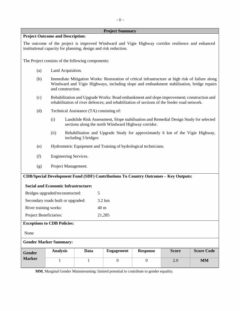
Project Outcome and Description:
The outcome of the project is improved Windward and Vigie Highway corridor resilience and enhanced
institutional capacity for planning, design and risk reduction.
The Project consists of the following components:
(a) Land Acquisition.
(b) Immediate Mitigation Works: Restoration of critical infrastructure at high risk of failure along
Windward and Vigie Highways, including slope and embankment stabilisation, bridge repairs
and construction.
(c) Rehabilitation and Upgrade Works: Road embankment and slope improvement; construction and
rehabilitation of river defences; and rehabilitation of sections of the feeder road network.
(d) Technical Assistance (TA) consisting of:
(i) Landslide Risk Assessment, Slope stabilisation and Remedial Design Study for selected
sections along the north Windward Highway corridor.
(ii) Rehabilitation and Upgrade Study for approximately 6 km of the Vigie Highway,
including 3 bridges:
(e) Hydrometric Equipment and Training of hydrological technicians.
(f) Engineering Services.
(g) Project Management.
CDB/Special Development Fund (SDF) Contributions To Country Outcomes – Key Outputs:
Social and Economic Infrastructure:
Bridges upgraded/reconstructed: 5
Secondary roads built or upgraded: 3.2 km
River training works: 40 m
Project Beneficiaries: 21,285
Exceptions to CDB Policies:
None
Gender Marker Summary:
Gender
Marker
Analysis Data Engagement Response Score Score Code
1 1 0 0 2.0 MM
MM, Marginal Gender Mainstreaming: limited potential to contribute to gender equality.

1. INTRODUCTION
BACKGROUND
1.1 Over a 24-hour period between December 24 and 25, 2013, an unseasonal low-level trough system
moving westward towards the Windward Islands chain, interacted with a mid to upper-level trough system
moving in a south to north direction (the December 2013 Trough Event). Heavy precipitation, high winds
and thunderstorm activity was generated along the eastern boundary of the trough as a result of this
interaction. The passage of the trough and accompanying torrential rainfall resulted in significant river,
flash flooding and landslide damage to mainland St. Vincent. Damage was sustained on both windward
and leeward sides of the island.
1.2 In the aftermath of extreme rainfall arising from the December 2013 Trough Event, Caribbean
Development Bank (CDB) assistance to GOSVG included: (a) an Immediate Response Loan (IRL) in the
amount of USD750,000 and (b) an Emergency Relief Grant (ERG) in the amount of USD200,000. These
funds were to assist GOSVG in the conduct of damage assessments, provision of emergency relief supplies
and humanitarian assistance, cleaning and clearing debris, as well as restoring essential services.
1.3 By letter dated February 20, 2014, GOSVG formally applied to CDB for a loan to assist in financing
a project for the rehabilitation and reconstruction of infrastructure destroyed by landslides, debris flows,
and flash and river floods resulting from the effects of the December 2013 Trough Event. The Project is of
high priority for GOSVG and is consistent with CDB’s Strategic Objective of supporting inclusive growth
and sustainable development in its Borrowing Member Countries (BMCs). The Project is also consistent
with CDB’s Corporate Priorities of promoting environmental sustainability. It is also consistent with the
strategic theme of the eighth cycle of SDF of promoting Environmental sustainability and Climate Change.
CDB, in its Country Strategy for St. Vincent and the Grenadines (2014-2018), indicated that the Bank
would support interventions that would contribute to strengthening of management capacity and the
reduction of risks in critical areas. This included support to improve climate and natural hazard resilience
of physical infrastructure.
1.4 The Project is being appraised under CDB’s Disaster Management Strategy and Operational
Guidelines (DiMSOG). The Guidelines allow the use of a Staff Report1/ to facilitate accelerated processing of loan applications.
Damage Assessment and Affected Areas
1.5 Local rainfall measurements indicate that peak rainfall intensity occurred over the 3-hour period
between 9:00 p.m. and 12:00 a.m. on December 24, 2013. Observed rainfall accumulations ranged between
163 millimetres (mm) to 312 mm at Belle Isle and Rabacca stations. Rainfall intensities were highest in
the northeastern quadrant of St. Vincent, with rainfall gauges in this area recording a maximum intensity
of 278 mm per 3-hour period. Expert opinion classified the 3-hour rainfall intensity as in excess of a
100 year return period event. Nine fatalities and 34 persons with injuries were recorded, with 3 persons
still missing.
1.6 Government declared as disaster areas, the villages of: Francois; Retreat; Vermont; Dubois; Hog
Hole; Cane Vale; Pembroke; Spring; Rose Bank; Dark View; Petit Bordel; Chateaubelair; Fitz-Hughes;
Richmond Vale; Gordon; Cumberland; and Troumaca; on the Leeward side of the island, and South Rivers,
O’Briens Valley and Spring Village, Georgetown on the Windward side. The combined impacted
1/ A Staff Report is an abbreviated appraisal report with emphasis on the impact of the event and the Government’s recovery
programme. The calculation of financial and economic rates of return as applicable for normal lending is omitted.
- 2 -
population for these areas is reported as 12,769 persons. The disaster declaration identified the event as a
level 2 disaster; a classification which indicates that national emergency response and recovery capacities
are not overwhelmed, but are limited and specialised regional and/or external assistance was requested.
1.7 Flood damage and landslides significantly impacted the transport, electricity and water sectors.
Several bridges were destroyed, roadways undermined, two hydropower-generating facilities were
disabled, and water services were cut to more than 50% of the population, due to the loss of transmission
pipes throughout the country. By January 6, 2014, service had been restored to 90% of the affected
population. Significant damage to residential housing was experienced and damage assessment reported
an estimated 662 homes damaged, of which 122 were completely destroyed. Communities most severely
affected included: Vermont; Troumaca; Spring Village; and Cumberland on the Leeward side of the island,
and South Rivers on the Windward side. (See Table 1.1). There are currently some 90 persons still in
shelters.
TABLE 1.1: HOUSING INFRASTRUCTURE AFFECTED
Level
Description
Number of
Houses
1 No significant damage – structure useable, requires minor repairs 396
2 Minor damage but structure cannot be occupied until repaired 144
3 Structure not usable and cannot be occupied until after major repairs 61
4 Structure condemned 61
Total 662
Source: Rapid Damage and Loss Assessment, January 16, 2014
1.8 Overall losses and damage are estimated at USD108.4 mn, equivalent to 15% of the 2012 gross
domestic product (GDP). Losses in the transport sector were estimated at USD82.6 mn2/or 76% of the total
losses. Damage and loss to the water, electricity generation and distribution sectors was estimated at USD4.5 mn and USD8.6 mn dollars, respectively. Estimated damage sustained at the Milton Cato
Memorial Hospital in the capital, Kingstown was USD2 mn.
1.9 The impact on the agricultural sector was primarily due to the disruption in transport access services
through the primary, tertiary and feeder road network. Agricultural production in the northern-affected
areas such as Georgetown and Sandy Bay, comprises primarily banana, root crops and vegetables. Loss of
crops and livestock and damage to agricultural feeder roads amounted to USD1.4 mn and this was unevenly
distributed across the island. Agriculture Region 3, which includes the North Windward district of the
island (Georgetown and Sandy Bay), suffered the greatest losses from the event, accounting for some 37.1%
of the total sector’s recorded damages. A detailed summary of damage and losses is presented in
Appendix 1.1.
1.10 In addition to sites located within the declared disaster areas, CDB staff visited other locations
which were also impacted by the December 2013 Trough Event. These areas included bridges at Union
along the Windward Highway; Yambou along the Vigie Highway; and Red Dog along the Teviot River.
The Yarabaqua and Caratal Rivers are both in need of river defences. In addition, feeder roads in the north
2/ Source: Rapid Damage and Loss Assessment undertaken by the World Bank (WB) with support from the European Union (EU)
in the Framework of the African, Caribbean and Pacific Group-EU Natural Disaster Risk Reduction Program managed by the
Global Facility for Disaster Risk Reduction (January 2014).

- 3 -
east of the island between Overland and Sandy Bay were visited. Sections of the Windward Highway3/ at
Orange Hill, Touruma and Magum/Overland were undermined from erosion, slope failure, and the loss of
retaining structures. Post-trough impact, bi-directional traffic flow along these sections has been
constrained to a single lane, and the risk of imminent total failure is high.
MACROECONOMIC CONTEXT
1.11 The economy of St. Vincent and the Grenadines (SVG) is small and open with a narrow resource,
production and export base, high import dependence and extreme vulnerability to external shocks, such as
the recent global recession; spikes in fuel and food prices; volatility in capital flows and natural disasters,
including hurricanes, volcanic eruptions, floods and droughts. Given the foregoing constraints and
vulnerabilities, accelerating and sustaining growth has become more difficult in the context of a more
competitive and dynamic global economy and inadequate resources to effect timely structural adjustments.
Nevertheless, as indicated by the construction of the new airport, SVG is determined to restructure its
economy, following the collapse of the banana industry, pivoting towards the further development of a
service-based economy with tourism at its centre.
1.12 Current indications are that SVG’s economy is continuing to rebound from the effects of the recent
global recession. Following average annual contraction of 1.7% between 2008 and 2010, GDP growth
accelerated from 0.3% in 2011 to 3.1% in 2013. This has occurred amidst the continuing downside risks
within dominant trading partners, notably the United States of America and the EU. While growth has
steadily improved, the continuing weakness in fiscal performance (current account, primary and overall
deficits) and the accumulation of public sector debt remain a concern.
1.13 The economic outlook is one of cautious optimism. The average annual growth forecast for the
medium term is approximately 3% with relatively stronger performance projected in 2017-2018. While the
December 2013 Trough Event would have slowed the growth trajectory somewhat, the expectation is that
the economy will continue to expand in the medium term. The forecast is premised on the gradual acceleration of the global economic recovery which, together with the completion of the Argyle
International Airport, brings expectations of some improvement in tourism sector performance; robust
investment tourism activity in the Grenadines; and an acceleration in public sector investment, given current
estimates of external grants (USD50 mn, mainly EU funds) and external loans (USD48.1 mn) over the 2013
to 2015 period including CDB loans4/.
DISASTER RISK MANAGEMENT
Emergency Management
1.14 The framework for disaster preparedness, response, planning, mitigation, and management was
established by the National Emergency and Disaster Management Act (2006), (the NEDM Act). This is
executed through the National Emergency Management Organization (NEMO), consisting of a National
Emergency Council (NEC), National Emergency Executive Committee (NEEC), and District Disaster
Management Committees (DDMC). The NEC is chaired by the Prime Minister and is composed of
ministers, permanent secretaries, district representatives and key ex-officio members from government
agencies, and corporations. The NEEC monitors progress on national disaster policy implementation and
provides technical implementation supervision on behalf of the NEC. DDMC’s function at the local level
3/ The Windward Highway is a two-lane wide, critical north-south coastal transit corridor for eastern St. Vincent, connecting rural
northern and central settlement areas to the capital Kingstown.
4/ National Economic and Social Development Plan, p.134.

- 4 -
and operate to implement planning and disaster response operations in their respective districts.
Additionally, local disaster committees have been organised to operate at the community level.
1.15 According to SVG’s National Disaster Plan (2005), upon the declaration and/or imminent threat of
a disaster, the National Emergency Operations Centre is activated under the direction of the Prime Minister,
by the National Disaster Coordinator (NDC) or designate. NDC is responsible for coordination of all
response and relief activities under the NEDM Act. Management and coordination of emergencies in SVG
is complicated by the spatial dispersion of the country, which comprises some 32 islands and cays.
1.16 SVG has had catastrophic insurance for hurricanes and earthquakes with the Caribbean
Catastrophic Risk Insurance Facility (CCRIF) since the inception of the Facility in 2007. The December
Trough Event did not generate wind speeds significant enough to trigger a CCRIF payout to GOSVG under
its tropical cyclone policy coverage. Had GOSVG procured policy cover under CCRIF’s new excess
rainfall product, it may have been eligible for a payout dependent on the rainfall parametric trigger points
selected under such policy cover.
Disaster Risk Reduction
1.17 Hazard analysis and experience shows that SVG is vulnerable to a variety of rapid onset hazards
including hurricane, storm surge, terrestrial flooding, volcanic eruption, earthquake, landslide, rock-fall,
tsunami and slow onset hazards such as drought. SVG is exposed to a number of anthropogenic hazards
such as marine traffic accidents and oil/chemical spills. SVG is located in a seismically active zone along
the eastern margin of the Caribbean tectonic plate. This, along with the location of La Soufriere, one of the
more active volcanoes in the Region, on the northern portion of the mainland St. Vincent, renders the island
particularly vulnerable to shallow seismic activity.
1.18 St. Vincent is characterised by steep inland topography with much of the population being
concentrated in coastal communities that are vulnerable to extreme wave events and storm surges as well
as flash flooding from riverine overflow and terrigenous runoff, associated with intense or high volume
precipitation events.
1.19 Disaster risk is likely to be further exacerbated by climate change (CC) and climate variability
trends. Consistent with the projected global median, CC models have forecasted that SVG will undergo
both warming and drying trends, with more frequent heat waves, droughts and high intensity rainfall events.
Increases in mean sea surface temperatures are also expected to increase storm intensities as well as storm
surges.
1.20 SVG is challenged in terms of data collection for rainfall and water level monitoring in its rivers.
Greater and more spatially representative network coverage is required for both rainfall gauges and water
level monitors. The Water Resources Management Unit (WRMU) of the Central Water and Sewerage
Authority (CWSA) maintains the largest active network of rainfall and water level monitoring stations on
the island. CWSA is a statutory corporation established in 1970, under the revised CWSA Act of 1991. A
total of six (two rainfall and four river flow) Central Water and Sewerage Authority (CWSA) maintained
monitoring stations were lost as a result of the passage of the December 2013 Trough Event. Capacity
deficits in both the current national network coverage and the quality of data collected by existing field
instrumentation, limit the development of resilient site specific infrastructure design, flood hazard,
emergency management and reduction plans. These deficits also restrict the potential for development of
early warning systems. Network coverage in the north of the island is particularly limited.
1.21 The challenges in data capacity, quality and management at the national level further impacts
analysis of hydro-meteorological data at a regional level, a function that is executed by the Caribbean

- 5 -
Institute for Meteorology and Hydrology (CIMH). CIMH maintains an archive of meteorological and
hydrological data from member countries of the Caribbean Meteorological Organisation, including SVG.
On behalf of GOSVG, CWSA currently and routinely provides hydro-meteorological data to CIMH.
1.22 GOSVG recognises that Disaster Risk Management (DRM) and disaster risk reduction (DRR) are
key elements in its sustainable development strategy. GOSVG’s DRM agenda is guided by the NEDM
Act, and the National Disaster Plan. GOSVG is a signatory and subscribes to the regional results-based
CARICOM Enhanced Comprehensive Disaster Management Framework (2014-2024). National progress
in hazard mapping has been limited but is improving, and sector mainstreaming of DRR in policies, plans
and in practical implementation is still in early development. NEMO has been successful in increasing the
public’s sensitisation and awareness of natural hazards and the need for individual and household
preparedness. GOSVG has been able to develop building code legislation as well as conduct standardised
vulnerability assessments of the health sector.
1.23 Over the period 2011 to 2013, GOSVG benefited from $5 mn of WB-financed disaster reduction
interventions under the Hurricane Tomas Emergency Recovery Loan. Under the Loan: (i) three schools
and three community centres, used as public emergency shelters, were rehabilitated; (ii) 30 metres of river
defence/bank stabilisation was constructed; (iii) 17 GOSVG officials were trained in Geographic
Information Systems mapping; and (iv) seven hazard maps were produced. GOSVG is expected to further
benefit from the findings of a flood risk reduction and hydraulic study for several windward watersheds
which is currently underway as part of the CDB-financed Hurricane Tomas RRL approved by the Board of
Directors in July 2011. This TA is expected to enhance GOSVG’s capacity to better manage flood hazards
through risk mapping, and the identification of cost-effective remedial civil works and non-structural
mitigation for drainage improvement. In May 2014, WB approved some USD35.6 m for a Regional
Disaster Vulnerability Reduction Project Loan in response to the impact of the December 2013 Trough
System. GOSVG is expected to benefit from this Facility, with impacted sites on the Leeward side of the
island, being targeted.
1.24 With support from the WB Regional Disaster Vulnerability Reduction Programme (RDVRP) and
Climate Investment Fund, Pilot Programme for Climate Resilience, GOSVG is currently developing a new
national physical development plan (NPDP) for the period 2014 to 2024, for which the methodological
framework has been elaborated. Building future resilience to natural hazards and CC is identified as a key
strategic planning priority to be addressed in the development of NPDP, going forward.
SOCIAL CONTEXT
1.25 The project sites are located on the eastern side of the island, in the Census Division of Sandy Bay,
Georgetown, Marriaqua, and Bridgetown. Preliminary documentation from the 2012 population and
housing census of SVG, recorded an aggregate population of 21,285 persons resident in the 4 electoral
districts (See Table 1.2). Communities in these districts, are located in sections of the island where the
highest concentrations and most severe states of poverty were recorded during the 2008 Country Poverty
Assessment (CPA). Poverty in Georgetown and Sandy Bay was recorded at 55.6%, Marriaqua, almost 30%
(29.6%), while poverty in Bridgetown was recorded at 24.0%.

- 6 -
TABLE 1.2: HOUSEHOLD POPULATION BY ENUMERATION DISTRICT
Census Division
Population
Male Female Total
Sandy Bay 1,374 1,232 2,606
Georgetown 3,596 3,453 7,049
Marriaqua 3,916 3,882 7,798
Bridgetown 1,958 1,874 3,832
TOTAL 10,844 10,441 21,285
1.26 Communities in the Project catchment areas display similar characteristics at varying levels (see
Appendix 1.2 for details). Residents are still recovering from the adverse impacts of the December 2013
Trough Event. For some, recovery has been extremely slow, having not recovered from previous shocks
to the island’s economy, including the impacts of previous natural disasters.
1.27 The vulnerability of both the Vigie and Windward Highways is a result of the island’s topography,
coupled with poor settlement, agriculture and development practices. The Windward Highway connects all
communities on the eastern half of the island to the principal centre of economic and social services and
the centre of commerce, in Georgetown and Kingstown. The Vigie Highway is a south-west to north-east
oriented transport corridor linking Kingstown to the Windward Highway at Peruvian Vale. It also provides
redundancy to the main north-south Windward Highway offering the central and north windward
communities north of Peruvian Vale a shorter, alternative cross-country route of accessing Kingstown, the
capital. En route to Kingstown, the Vigie Highway traverses an urban commercial settlement node, locally
known as “Mespo” (Marriaqua) at a complex junction of four roads, and three river-spanning bridges
(Teviot, Zenga & Yambou). The junction is a busy, high traffic area, at which a health centre, abattoir,
police station, doctor’s office, community centre, church, and school are located. Three secondary schools
and three primary schools are located within a 0.5 km radius of the junction. Physically, the junction serves
as a central transport hub, for school children and other commuters, into Kingstown as well as to more rural
areas.
1.28 Marriaqua and Bridgetown are in the Agriculture Region, Region 2. Marriaqua is particularly
important as Mesopotamia Valley, the breadbasket of St. Vincent is located in Marriaqua. Mespotamia
Valley is very fertile, with farmlands where root crops, fruits, vegetables and spices are grown. The area
is essential to food security in the country. Sections of the Valley are heavily prone to flooding, land
slippage and rock falls, exacerbated by human factors such as the dumping of waste in the water ways,
lack of river maintenance, squatting on river banks for settlement and agricultural activity, and irresponsible
farming practices on steep slopes. Most of the essential services of Marriaqua are located in the major flood
zone where the Zenga, Teviot and Yambou meet.
GENDER CONTEXT
1.29 There was no reliable social or sex disaggregated data presented on the impact of the event. This
makes attempts to formulate a vulnerability profile of different groups of men and women in the targeted
project areas difficult. NEMO confirmed that the poor in SVG are considered the most vulnerable to natural
disasters. The 2008 poverty assessment described persons living in poverty and most vulnerable to poverty
as persons from rural communities, especially the banana farming population, persons from large families,
and members of female single parent/female headed households. It is expected that recommendations and

- 7 -
data collected from the Country Gender Assessment currently being conducted in SVG will be used to
construct baseline data for the project.
1.30 Unsustainable development practices and poor living conditions, contributed to the intensity of
destruction and loss, as well as the capacity of the population on the eastern side of the island to recover
from the event. These conditions persist and recurrent events of this nature, have resulted in irreversible
social dislocation for a number of households. Mitigation measures to reduce land slippage and flooding
are essential to minimize these adverse impacts, promote economic growth, and for poverty reduction in
affected areas. These measures will however need to be accompanied by holistic interventions that monitor
and mitigate social practices that will affect the sustainability of the interventions implemented, supporting
the need for studies in project sites that raise the greatest concerns.
PREVIOUS CDB-FUNDED DISASTER MANAGEMENT PROJECTS
1.31 CDB has approved a total of USD15.94 mn for disaster management projects and related activities
in SVG over the period 1986-2013. Appendix 1.3 presents a listing of projects undertaken over that period.
In 2011, the largest intervention so far, was approved. This was a Rehabilitation and Reconstruction Loan
(RRL) amounting to USD12.6 mn, to assist with the rehabilitation and reconstruction of critical
infrastructure damaged by Hurricane Tomas.
1.32 Although the Loan Agreement was signed in November, 2011, conditions precedent to first
disbursement were not satisfied until January 2013, with the first date of disbursement being March 2, 2013.
This delay in implementation was due to a number of reasons, including difficulty experienced in procuring
a Project Coordinator (PC), a condition precedent to first disbursement. GOSVG had great difficulty in
attracting suitable candidates, based on the remuneration package proposed. Having exhausted available
avenues, GOSVG sought to fill the position through secondment of staff. Since the appointment of PC
in 2013, some progress has been made. Tender documents have been prepared for some of the works
packages, and bids are due by the end of June 2014. It is expected that construction of works will start in
the third quarter of 2014. Of the two TA’s which were components of the RRL, one, the Coastal Study of
Sandy Bay and Dark View, has been completed, and the resulting recommendations are being used to
inform the design of two capital projects, one under the RRL (Tomas), and another being funded by the
World Bank. The Final Report for the other TA, “A Hydraulic Assessment for Flood Risk Reduction” is
expected in the third quarter of 2014.
LESSONS OF EXPERIENCE
1.33 The lessons of experience that apply to this Project have been taken from the Assessment of CDB
Natural Disaster Risk Management Assistance for its BMCs5/, the Country Assessment Report for SVG6/
and the recent experience with the RRL for the Hurricane Tomas event. The key lessons learned are
summarised as follows:
(a) human resource constraints contribute to the slow pace of project implementation and the
effectiveness of the intervention; and
5/ Le Groupe-conseil baastel Itee and Environmental Solutions Limited. Assessment of the Caribbean Development Bank's Natural
Disaster Risk Management Assistance for its Borrowing Member Countries – (1998-2006). April 2009.
6/ Le Groupe-conseil baastel Itee and Environmental Solutions Limited. Assessment of the Caribbean Development Bank's Natural
Disaster Risk Management Assistance for its Borrowing Member Countries – (1998-2006). Country Assessment Report -
St. Vincent and the Grenadines. October 2008.

- 8 -
(b) infrastructure DRM projects and TA provide an opportunity to raise awareness with respect
to the connection between DRM and development activities and to strengthen risk
reduction capacity, and this contributes to the sustainability of the intervention.
1.34 The lessons reflected in the Project design are as follows:
(a) the project management arrangements address MTW’s staffing limitations through the
establishment of a dedicated project team in the Ministry’s Project Management
Division (PMD), to be funded from loan resources. This team will be responsible for
project implementation, reporting and monitoring. The team will help to address the
Ministry's technical human resource capacity constraints; In addition, given the difficulty
in recruiting a PC for the last RRL, the proposed remuneration package has been enhanced
in order to attract a PC with the requisite skills to implement the project.
(b) institutional strengthening and TA components will support and strengthen capacity in
SVG for effective management of landslide hazards as well as improving the capacity for
better management of flood risk hazards.
2. THE PROJECT
OUTCOMES
2.1 The outcome of the Project is: Improved Windward and Vigie Highway corridor resilience and
enhanced institutional capacity for planning, design and risk reduction.
2.2 This is to be achieved through: (a) restoration of road sections and bridge structures with immediate
risk of failure on the Windward Highway and the Vigie Highway; (b) the reconstruction of critical
infrastructure on the Windward corridor to higher standards using information from current studies;
(c) undertaking a rehabilitation and upgrade study of a section of the Vigie Highway; (d) undertaking a
landslide risk assessment and slope stabilisation study along sections of the North Windward Highway
corridor; and (e) providing equipment for rainfall and stream flow monitoring and for training in hydrology.
A Design and Monitoring Framework summarising the characteristics of the Project is presented in
Table 2.1.
RATIONALE
2.3 Landslides, rock and debris flows, river and flash floods were the major causes of damage and
losses, fatalities and injuries, during the December 2013 Trough Event. There remains an immediate threat
of failure to critical infrastructure along both the Vigie and Windward Highways. Along the Vigie highway,
sections at high risk are the Yambou, Teviot and Zenga Bridges and the road embankment at Glenside.
Along the Windward highway, embankment sections at Tourama, and Magum have failed and threaten the
total collapse of the road. Urgent intervention is needed to address these sections.
2.4 The Windward Highway is a critical north-south coastal transit corridor for eastern St. Vincent,
connecting rural northern and central areas to the capital, Kingstown. Redundancy is limited along this
corridor and, where available, is restricted to some secondary and agricultural feeder roads oriented parallel
to and inland of the Highway. As a consequence of landslides that occurred along the North Windward
Highway at Orange Hill, Touruma and Magum, access to and egress from the poor and vulnerable
communities of North Windward is threatened.

- 9 -
2.5 The Vigie Highway is a critical transportation corridor that meanders through the Mesopotamia
community crossing three rivers, the Yambou, the Teviot and the Zenga. The Yambou, Teviot and Zenga
Bridges are located in very close proximity to public institutions such as a health centre, three primary
schools and a police station. The Teviot and Zenga bridge crossings are major elements in the transportation
link which enables residents from the poor and vulnerable communities of Marriaqua to access transport.
Hydraulic models from a current CDB-financed study7/ indicate overtopping of all three bridge structures for rainfall events with a 1 in 25-year frequency which is consistent with what occurred during the
December 2013 Trough Event. All three structures sustained major structural damage as a result of high
velocity flows and transported boulders and debris and are in urgent need of remedial works.
2.6 Some of the feeder roads in the north and central windward districts were severely damaged, thus
affecting the transportation of produce to the Kingstown markets. In addition, since some of the feeder
roads provide redundancy8/ within the North Windward Highway corridor, the failure of these roads, as
well as that of critical parts of the Highway as occurred during the December 2013 Trough Event, resulted
in many northern communities becoming inaccessible.
2.7 A number of rainfall gauges and water level monitoring stations maintained by CWSA were lost
during the December 2013 Event. These exacerbated the problem faced by GOSVG in terms of data
collection for rainfall and water-level monitoring of the rainfall gauges. Capacity deficits in both the current
national coverage and the quality of data collected by existing field instruments limits the availability of
site specific design information. This information is critical for flood hazard, emergency management and
reduction plans, as well as for facilitating the development of early warning systems.
LOCATION OF THE PROJECT
2.8 The Project Location Map is presented at Figure 1.
PROJECT DESCRIPTION
2.9 The Project consists of the following:
(a) Land: Land acquisition of approximately 370 m2 of private property to facilitate slope and
embankment rehabilitation at the Magum site adjacent to the North Windward Highway.
(b) Works Package 1a and 1b: Immediate Mitigation Works: Restoring of critical
infrastructure at high risk of failure. This includes:
(i) slope and embankment stabilisation and rehabilitation works at selected critical
sites along Windward and Vigie Highways;
(ii) reinstallation of guardrails and carrying out structural repairs to bridges at
Yambou, Teviot and Zenga bridges on the Vigie Highway and bridge rehabilitation
at Union on the Windward Highway; and
(iii) Construction of a bridge at Red Dog in Mesopotamia.
7/ Hydraulic Assessment and Flood Risk Reduction Study.
8/ Alternative roadways.

TABLE 2.1: DESIGN AND MONITORING FRAMEWORK
- 10 -
Narrative Summary Objectively Verifiable Indicators Means of Verification Assumptions/Accountabilities
1. IMPACT:
Contribute to increased resilience to natural disasters in
the transport and agricultural sectors in St Vincent.
1. Sectoral and other losses associated with
flood and landslide hazards reduced from 15% of GDP to 10% by December 2018.
1. SVG’s Annual Statistical and
Economic Reports.
2. Macro Socio-Economic and
Environment Assessments of
damage and loss caused by weather-related events.
1. Stable macro-economic environment.
2. OUTCOMES:
(a) Improved Windward and Vigie Highway corridor resilience and enhanced institutional capacity for
planning, design and risk reduction.
1. Reduction in the number of working days lost
at impacted sections due to landside and flood-
related traffic disruptions, by 50% by January
2018.
2. 50% of study recommendations used by
GOSVG by 2018.
3. 50% increase in hydro-meteorological data
capture, use and analysis by GOSVG agencies
1. MTW reports.
2. NEMO damage assessments 3. MTW design reports
4. CDB’s ex-post evaluation reports.
5. Hydrometric equipment inventory
6. Post disaster socio-economic
damage and loss assessments.
7. Project Completion Reports (PCR).
1. GOSVG support for comprehensive
disaster management strategies and
plans.
2. GOSVG implements recommendations of risk assessment study.
3. GOSVG commitment and availability of resources to implement recommendations.
3. OUTPUTS:
Infrastructure Works:
1. Infrastructure Works at imminent risk of failure
rehabilitated.
2. Infrastructure Works reconstructed and upgraded.
3. Essential Hydrometric Equipment Installed.
1. Works Package 1 along the Windward and
Vigie Highway completed by December 31,
2015.
2. Work Package 2 in the Windward Districts completed by February 2017.
3. Work Package 3 along the North Windward Highway completed by September 2016.
4. Hydrometric equipment installed by June
2015.
1. Site inspections. 2. Consultant’s Supervision
Reports.
3. PC’s reports. 4. Final Report of Risk Assessment
Studies.
5. Engineering Consultant’s PCR.
1. MTW adequately maintains project
infrastructure.
2. Infrastructure works effectively completed.
TA – Studies:
1. Recommendations for enhanced rehabilitation and
upgrade of 6 km of transportation corridor of the Vigie Highway.
Final consultancy report completed by
September 2015.
Project Coordinator Report. 3. GOSVG accepts recommendations of
landslide risk assessment study.
2. Recommendations for enhanced resiliency to landslide
and slope instability selected sites along the North Windward Highway.
Final risk assessment studies on landslide and
slope instability completed by September 2015.
PC’s Report. 4. GOSVG accepts recommendations of landslide and slope instability study.
Certified staff in Hydrology. 1. Issued CIMH Mid-level certificate in
Hydrology – one Technician.
2. Issued CIMH diploma in Hydrology – one
Technician.
Certificate received. Deployment of trained persons in appropriate positions.

TABLE 2.1: DESIGN AND MONITORING FRAMEWORK - 1
1 -
Narrative Summary Objectively Verifiable Indicators Means of Verification Assumptions/Accountabilities
4. Activities/Inputs $’000 1. Consultant’s Monthly Progress
Reports.
2. Project Manager’s reports.
3. CDB Site supervision visits.
4. Quarterly Reports on Investment
Costs.
5. CDB disbursement records.
1. GOSVG counterpart contribution available.
2. No major adverse weather
conditions.
3. Timely requests for disbursement of
funds.
Item Total
CDB
GOSVG OCR GRANT SFR
1. Infrastructure 17,603 11,271 - 2,577 3,755
2. Services 7,098 - 556 5,585 957
Sub-Total 24,701 11,271 556 8,162 4,701
3. Contingencies 4,664 2,724 41 990 909
4. Financing Charges 1,279 934 - 344 -
Total Project Cost 30,644 14,929 597 9,496 5,621
Project Outcome Indicators
Baseline
2014 Year 1 Year 2 Year 3
Report and
Frequency
Responsibility for
Data Collection
1. Reduction in costs for infrastructure damage due to flooding and 21 mn 0 5 7 Annual MTW landslide events in project areas.
2. Reduction in the number of working days lost due to landsides related 3 0 2 1 Annual MTW
traffic disruptions. 3. Hydrology equipment installed (rainfall and water level monitoring
gauges) by June 2015.
16 26 34 Annual MTW
Intermediate Results for Components: (%) (%) (%)
Component 1: Infrastructure Works
- 40 60 100 Progress Reports PC 1. Works Package 1 along the Windward and Vigie Highway completed
by December 31, 2015.
2. Work Package 2 in the Windward Districts completed by February - 40 60 100 Progress Reports PC
2017.
3. Work Package 3 along the North Windward Highway completed by - 40 60 100 Progress Reports PC
September 2016.
4. Hydrometric equipment Installed by June 2015 - 50 100 Progress Reports PC
Component 2: TA
- 70 100
-
Supervision Reports PC 5. Rehabilitation and Upgrade Study for the La Croix to Peruvian Vale
section of the Vigie Highway.
6. Risk assessment studies to identify feasible recommendations on - 70 100 Supervision Reports PC
managing landslide and capacity building for MTW.

- 12 -
(c) Works Packages 2: Infrastructure Rehabilitation and Upgrade: This comprises:
(i) construction and rehabilitation of river defences along sections of Caratal and
Yarabaqua rivers; and
(ii) rehabilitation of 3.2 km of agriculture feeder roads;
(d) Works Packages 3: Infrastructure Rehabilitation and Upgrade – Orange Hill: This
comprises road embankment and slope improvement at Orange Hill on the Windward
Highway;
(e) TA consisting of:
(i) Landslide Risk Assessment, Slope Stabilisation and Remedial Design Study for
selected sites along the North Windward corridor. The selected sites are: Orange
Hill; Soldier Hill; Windblow; Owia; Bloody Bridge Point Hill; Boat Bay; and
Spring;
(ii) Consultancy Services for the Preparation of a Rehabilitation and Upgrade Study
for 6 km of road from La Croix to Peruvian Vale along the Vigie Highway
including associated bridges;
(iii) Institutional Strengthening, including the procurement of hydrologic equipment
for rainfall and stream flow measurement for use by the Water Resources Unit
based at CWSA; and training of hydrological technicians;
(iv) Engineering consultancy Services for the design of the infrastructure works and
supervision during construction; and
(v) Project Management - a project team within MTW’s PMD to manage the
implementation of all activities related to the Project.
2.10 Further details of the Project are presented in Appendix 2.1. Draft Terms of References (TOR) for
the Training of Hydrological Technicians. Consultancy Services for undertaking a Rehabilitation and
Upgrade Study for Vigie Highway and Associated Bridges, and Landslide Risk Assessment and Slope
Stabilisation Study are set out at Appendices 2.2, 2.3 and 2.4, respectively.
DESIGN CONSIDERATIONS
2.11 Appropriate local and international design standards and guidelines will be used in the design of
roads, drainage elements, river defence, and retaining structures. These will be prepared by suitably
qualified and experienced engineering consultants under the supervision of MTW.
2.12 The inputs for the design for the La Croix to Peruvian Vale section of the Vigie Highway would be
informed by the evidence-based decisions made by MTW after receiving recommendations from the
Hydraulic Assessment and Flood Risk Reduction Study currently being executed under CDB’s Natural
Disaster Management RRL Hurricane Tomas/North Windward Project, due to be completed by the third
quarter of 2014.
2.13 The proposed Landslide Risk a Slope Stability TA when completed is also expected to propose
long-term mitigation measures to the potential impact of landslides along the Windward Highway.

- 13 -
PROJECT COST
2.14 The Project is estimated to cost $30.644 mn. Estimates of the cost for rehabilitating and
reconstructing roads, bridges, and river defenses, are based on tender prices for similar work currently
being carried out in SVG. CDB staff have reviewed these estimates and are satisfied that they are
reasonable and have appropriate levels of contingencies. Table 2.2 presents a summary of the estimated
costs of the project components and the details of the cost, financing and phasing of the Project are
provided at Appendix 2.5.
TABLE 2.2: SUMMARY OF PROJECT COST AND FINANCING
Item
Total
CDB
GOSVG OCR SFR GRANT
1. Infrastructure 17,603 11,271 2,577 - 3,755
2. Services 7,098 - 5,585 556 957
Sub-total 24,701 11,271 8,162 556 4,712
3. Contingencies 4,664 2,724 990 41 909
4. Financing Charges 1,279 934 345 - -
Total Project Cost 30,644 14,929 9,497 597 5,621
USD Equivalent 11,350 5,529 3,517 221 2,082
% Financing 100 49 31 2 18
FINANCING
2.15 The Project will be financed by:
(a) a loan from CDB to GOSVG of an amount not exceeding the equivalent of
USD9.046 mn representing 80% of the project cost, comprising USD5.529 mn from
CDB's OCR and USD3.517 mn from CDB's SFR, to assist with financing the
infrastructure works, TA, engineering services, project management and finance
charges;
(b) a grant of USD221,000 from CDB’s SFR to fund institutional strengthening; and
(c) counterpart funding of the equivalent of USD2.082 mn to assist with financing the cost
of the infrastructure works, TA, engineering services, and project management.
The proposed OCR loan is repayable in 22 years, inclusive of a grace period of 5 years. The OCR
interest rate is variable and is currently 3.95%. A commitment charge of 1% p.a. is payable on the
undisbursed balance of the OCR loan from on the sixtieth day after the date of the Loan Agreement.
The SFR portion of the loan is repayable in 25 years, inclusive of a grace period of 5 years. The SFR
interest rate is fixed at 2.5% p.a.
This information is withheld in accordance with one or more of the exceptions to
disclosure under the Bank’s Information Disclosure Policy.

- 14 -
IMPLEMENTATION
2.16 The Project will be implemented by MTW’s PMD. The project will be implemented over a
36- month period commencing September 2014, and ending May 2017. The proposed Project
Implementation Schedule is presented in Appendix 2.6 and the Project Implementation Support Plan is
set out at Appendix 2.7.
DISBURSEMENT
2.17 Disbursement of the Loan will be made in accordance with CDB’s Guidelines for the
Withdrawal of Proceeds of the Loan. It is expected that the first disbursement from the Loan will
be made by October 30, 2014, in respect of Project Management. The Loan is expected to be fully
disbursed by May 31, 2017. An Estimated Quarterly Loan Disbursement Schedule is presented at
Appendix 2.8.
2.18 Disbursement of CDB Grant funds for the provision of training for CWSA hydrological
technicians will be made subject to providing that formal identification of candidate students for the
CIMH mid and Diploma-level technician training programme. It is expected that first disbursement of
the Grant will be made by March 31, 2015, and is expected to be fully disbursed by August 31, 2016.
PROJECT MANAGEMENT
2.19 All major roads, drainage and infrastructure construction works are the responsibility of
MTW. PMD, within MTW, reports directly to the Chief Engineer who reports to the Permanent
Secretary, MTW. PMD is organised into project teams responsible for the implementation of civil
and building projects funded through external agencies. It is proposed that the project management
function be housed in the existing PMD within MTW. Based on the current workload of PMD, and
further to discussions between CDB and MTW, it is the opinion of CDB staff that an additional Project
Team (PT), comprising a Project Coordinator (PC) (as team leader), one Project Engineer (PE), a Project
Manager Hydrology (PMH) and an Administrative/Accounting Officer (AO), will be required to
effectively manage the proposed Project. CDB will finance the PC, and PE and GOSVG will provide
the AO. The qualifications and experience of PT must be acceptable to CDB as well as any persons
subsequently engaged or assigned to posts with PT.
2.20 It is condition precedent to first disbursement of the loan that GOSVG select and engage in accordance with the procurement procedures applicable to the loan, the services of PC. PC will report to the Chief Engineer of MTW and will be responsible for coordinating, monitoring and managing all aspects of the implementation of the project.
2.21 The PT will manage all aspects of the implementation process, including supervision of engineering consultants, the procurement of hydrology equipment and securing training of two staff members of CWSA. GOSVG shall procure that CWSA assign PMH. PMH will facilitate the work of the suppliers to make available relevant information and to facilitate the completion of the exercise. PMH will act as a liaison between the suppliers and GOSVG officials and report to the PC. The PC will provide a report to CDB confirming equipment supplied and installed. GOSVG will be responsible for providing suitable accommodation, transportation, office equipment and supplies for PT. The proposed management structure is presented in Appendix 2.9. 2.22 It will also be a condition precedent to disbursement, in respect of construction works, that
GOSVG select and engage, in accordance with the procurement procedures applicable to the Loan, the

- 15 -
services of one PE, whose qualification and experience is acceptable to CDB. The PE will report to PC,
with specific responsibilities for assisting PC with supervising the consultants and managing the
implementation of construction works under the Project. The TOR for the PC, PE and AO are set out at
Appendix 2.10.
CONSULTANCY SERVICES
2.23 GOSVG will be required, before any disbursements for the construction works, to engage
consultants in accordance with the procurement procedures applicable to the Loan for the
engineering services required in relation to the works as specified in Appendices 2.11, 2.12 and 2.4.
2.24 It will be a condition precedent to the disbursement with respect to the immediate mitigation
works (Works Package 1a and 1b) that GOSVG engage consultants, whose qualifications and
experience are acceptable to CDB, to provide the engineering services specified in Appendices 2.11.
2.25 It will also be a condition precedent to the disbursement with respect to the infrastructure
rehabilitation and upgrade works (Works Package 2 that GOSVG engage consultants whose
qualifications and experience are acceptable to CDB, to provide the engineering services specified in
Appendices 2.12.
2.26 GOSVG will also be required, to engage the services of Consultants for each TA in
accordance with the procurement procedures applicable to the Loan. The cost of these services will be
financed by CDB. (Responsibilities of these Consultants are set out at Appendices 2.3 and 2.4). It will
be condition precedent to the disbursement with respect to the infrastructure rehabilitation and upgrade
works (Works Package 3 – Orange Hill) that GOSVG engage consultants whose qualifications and
experience are acceptable to CDB, to provide the engineering services specified in Appendices 2.4
PROCUREMENT
2.27 Procurement of capital works and consultancy services will be in accordance with
CDB’s DiMSOG. The Procurement Plan is provided at Appendix 2.13.
ENVIRONMENTAL ASSESSMENT
2.28 The Project is not anticipated to have any significant adverse environmental impacts including impacts on critical or other natural habitats. The works proposed involve de-silting; retraining and stabilising distal sections of the Caratal and Yarabaqua Rivers; controlling erosion; rehabilitating feeder roads; constructing retaining structures and stabilising slopes along existing roadways; and reconstructing bridges at: Union River along the Windward Highway; Yambou River along the Vigie Highway; and Red Dog along the Teviot River. Slope stabilisation and flood management measures will result in positive impacts through reduction of public safety risk, livelihood loss, property and environmental damage.
2.29 The Project will contribute positive long-term development impact, by improving institutional and technical capacity for landslide risk assessment and slope stabilisation along the primary road network in the north windward area. Improved capacity is expected through enhanced mapping, analysis and assessment of: slope stability, drainage and geotechnical conditions, levels of risk, primary and secondary causal factors of slope movement, and development of cost effective slope stabilisation, protection and landslide remediation measures. Further, the Project will upgrade and expand the national network of water level and rainfall monitoring stations in SVG, and improve institutional capacity for monitoring to: better manage flood hazard risk; enhance evidence-based physical planning; and provide data to facilitate more optimal, site-specific design of future mitigation
- 16 -
infrastructure. The rehabilitation and upgrade study for the Vigie Highway and associated bridges is expected to identify climate vulnerabilities, appropriate least- cost resilience measures and levels of acceptable risk that will deliver a degree of climate proofing over the expected design life of the proposed highway improvement.
2.30 The potential adverse environmental impacts related to the proposed works which are likely
to occur during the construction period include:
(a) pollution from fugitive dust emissions during loading, unloading and the transportation
of construction material;
(b) noise pollution;
(c) improper disposal of waste, excavated construction spoil and silt material;
(d) contamination and siltation of riverine and marine environments due to runoff from
river- training activities;
(e) erosion and sedimentation from exposed surfaces during construction;
(f) traffic delays; and
(g) public and worker safety.
2.31 Construction-related adverse environmental impacts which are likely to occur are expected to
be short term and can be effectively managed with the adoption of appropriate mitigation measures
during construction, supplemented by effective monitoring and supervision during implementation.
The project design process will include an analysis of alternatives for construction works that will be
reviewed for potential impacts and enhanced environmental sustainability. A draft Environmental
Management and Monitoring Plan (EMMP) will be prepared by the Engineering Consultants during the
detailed design stage. Appropriate provisions of the EMMP, which are designed to mitigate the
construction impacts, will be included in the technical specifications of the bid documents and itemised
for contractor pricing in the Bills of Quantities of the bidding documents for the various works
contracts. Contractors will be required to identify and develop operational plans on how they propose to
implement the works.
2.32 The technical specifications to be included in the bidding documents for the works, will
include, but not be limited to, requirements for: (i) management of waste, construction materials and silt,
including transportation and disposal; (ii) siltation control; (iii) noise and dust abatement; (v) traffic
management; and (v) health and safety considerations.
ENVIRONMENTAL MONITORING
2.33 During construction, the Supervising Engineering Consultants will be required to monitor and
report on the contractors’ operations for conformance with the mitigation measures stipulated in the contract
documents. CDB staff will provide general oversight of the environmental aspects of project
implementation.

- 17 -
PERFORMANCE EVALUATION RATING
2.34 The existing composite performance rating based on CDB’s Project Performance
Evaluation System (PPES) has been estimated at 6.0. This is a highly satisfactory rating. The details of
the ratings of the PPES are presented in Table 2.3.
TABLE 2.3: PROJECT PERFORMANCE EVALUATION
Criteria Score Justification
Strategic
Relevance
7.0 The Project is of high priority for GOSVG as it contributes to the
country's recovery efforts following the passage of the December 24-25,
2013 trough event whilst reducing risks associated with landslide and
flood hazards.
Poverty
Relevance
6 The rehabilitation of critical economic infrastructure will facilitate the
restoration of feeder roads and the enhancement of livelihoods of the
farming community in the project area. The area has the highest poverty
level in the country and a population that is vulnerable to landslides and
flooding. The Project will contribute to a reduction in the vulnerability
by minimizing the losses suffered by households during such events.
Some employment for skilled and unskilled labour will be realized during
the construction period.
Efficacy 6 The Project is highly likely to meet its stated physical and institutional
objectives. The designs for the roads, bridges and river defences, will
take into account the need for rehabilitated infrastructure to be able to
withstand similar heavy rainfall events; in addition, through the provision
of training and hydrologic equipment, the Project will contribute towards
reducing the country's vulnerability to heavy rainfall events.
Cost Efficiency 5 Under DiMSOG, a Staff Report omits the calculation of financial and
Economic Rates of Return as applicable for normal lending. However,
the engineering design process will facilitate the selection of least-cost,
technically feasible options for achieving the project objectives.
Institutional
Development
Impact
6 The TA components of the Project will enhance GOSVG’s, and in
particular MTW’s, ability to manage landslide risks and improve the
effectiveness of GOSVG’s disaster response systems.
Sustainability 5.5 The infrastructure works will be designed with adequate protection
measures to mitigate damage from future natural disasters. Whilst budget
constraints may limit GOSVG’s ability to fulfill its overall maintenance
mandate, the Project is not likely to increase GOSVG’s maintenance
burden.
Overall
Performance
6
Highly Satisfactory
MONITORING AND REPORTING
2.35 PC will be responsible for monitoring and reporting on the outputs of the Project, and for
finalising the Design and Monitoring Framework set out in Table 2.1. It will be a condition of the Loan
that GOSVG shall furnish, or cause to be furnished to CDB, the reports listed in Appendix 2.14 to this
Report, in such form or forms as CDB may require, not later than the times specified therein for so
doing.

- 18 -
MAINTENANCE
2.36 It will be a condition of the Loan that GOSVG adequately maintains the infrastructure
financed under the Project. As a further condition of the Loan, GOSVG, through MTW, will be required to
undertake annual condition assessments of the project infrastructure, commencing no later than six
months after the certificate of practical completion, or equivalent, is issued by the engineering
consultants. The assessments shall be conducted under the supervision of the Chief Engineer, MTW.
Further, GOSVG shall no later than December 31 of each year, commencing in 2018, provide CDB
with a 3-year maintenance plan for the project infrastructure and shall provide the resources required
for the maintenance of the project infrastructure in accordance with the funding indicated in the 3-year
maintenance plan.
2.37 It will be a condition of the Loan that GOSVG/CWSA shall routinely maintain all water level
and rain gauge monitoring equipment financed with CDB grant resources and cause the same to be kept in
good condition and repair; providing the resources necessary to implement the maintenance works
required.
2.38 It will be a further condition that CWSA shall share hydrometric data collected with,
and/or generated by, the CDB-financed water level and rain gauge monitoring equipment with other key
GOSVG agencies including but not restricted to: MTW; Ministry of Physical Planning: Ministry of
Agriculture; as well as with CIMH.
3. RISK ASSESSMENT AND MITIGATION
3.01 The overall risk of the proposed project, as presented in Table 3.1 below, can be assessed as minor.
TABLE 3.1: SUMMARY OF KEY RISKS AND MITIGATION MEASURES
Risk Type Description Mitigation Measures
Operational Recruitment of PC: Delay in procuring PC with
requisite skills set.
This problem was encountered in implementation
of last RRL to SVG. The budget for PMU has been
increased so as to attract persons with the right
skills set.
Construction Risk: 1. Limited number of eligible
local contractors and low
interest from international
contractors may delay
implementation of project.
2. Risk of cost overruns or
time delays due to lack of
geotechnical and subsurface
data may increase the scope
of work.
Because of the relatively small project cost
components, regional or international contractors
may not be willing to bid. The project components
have been packaged in such a manner as to attract
bidders from outside SVG.
Cost estimates are based on recent tender prices in
SVG. In addition, adequate contingencies have
been provided to ensure the completion of the
proposed components.

- 19 -
Risk Type Description Mitigation Measures
Maintenance Risk:
Inadequate maintenance of
project infrastructure due to
budgetary constraints. This
could lead to a reduced design
life.
In the short and medium term, the infrastructure
rehabilitated under this project, is expected to lead
to a decrease in the current maintenance
requirements at the project sites. In addition,
maintenance of infrastructure in SVG is the
responsibility of BRAGSA*, who normally give
priority to highways and critical roadways, when
scheduling maintenance.
Natural Disaster Risk The implementation of works
to be undertaken, will be
extremely sensitive to adverse
weather conditions.
The scheduling of construction will take this into
account, and work in those sensitive areas will be
carried out outside the traditional hurricane season.
The Contractor is also required to take out
insurance against such an eventuality.
* BRAGSA - Roads, Building and General Services Authority
4. THE BORROWER AND EXECUTING AGENCY
GENERAL
4.1 The Borrower is GOSVG and the Executing Agency for the Grant is CWSA.
THE BORROWER
4.2 GOSVG may, pursuant to Section 3(1) of the Loans (Caribbean Development Bank) Act 1973
of SVG [the Loans (CDB) Act], in such manner and on such terms and subject to such conditions as
may be agreed between GOSVG and CDB, borrow from CDB from time to time such sums as may be
required by GOSVG. Any agreement between GOSVG and CDB in respect of sums borrowed under this
power must be made in the name of GOSVG and may be signed on behalf of GOSVG by the Minister
responsible for Finance or by any person authorised thereto in writing by that Minister. A copy of such
agreement must be laid before the House of Representatives as soon as possible after it is concluded.
4.3 Pursuant to Sections 3(6) and 10(4) of the Loans (CDB) Act, all amounts required for the
repayment of any sums borrowed by GOSVG from CDB under Section 3(1) of the Loans (CDB) Act,
or guaranteed under Section 7 of the Loans (CDB) Act, and all interest and other charges on such sums
are charged upon, and payable out of, the Consolidated Fund of SVG. Under Section 7(2) of the
GGLA where any sum becomes payable by GOSVG pursuant to a guarantee or undertaking given under
Section 5, that sum shall be charged on the Consolidated Fund and the Minister shall direct payment
to come out of that Fund accordingly.
THE EXECUTING AGENCY
4.4 CWSA was established by Section 3 of the Central Water and Sewerage Authority Act, 1991
(No. 17 of 1991) of SVG (the Act) to manage, construct, operate and maintain works in relation to the
supply of water and the disposal of sewage in SVG. CWSA is a body corporate with perpetual
succession and a common seal, with power to sue and to be sued in its corporate name, and to
exercise such powers and perform such duties as are conferred and imposed on it by the Act. Further
details of the legal status of CWSA are set out in Appendix 4.1.

- 20 -
FISCAL PERFORMANCE
4.5 As a result of the steep decline in revenues and expanded social pressures for protection of the
poor and the vulnerable against the effects of the recession, the current, primary and overall budgetary
balances all deteriorated during the height of the recession, and for the most part have continued to
be in deficit. The current account deficit averaged 1.5% of GDP during 2008 to 2013. The overall
budgetary deficit averaged 2.3% of GDP during the period, reaching 6.1% of GDP in 2013, while the
primary deficit averaged 1.2% of GDP, reaching 3.7% of GDP in 2013. Driven by continuing
weaknesses in the fiscal accounts, but also in part by borrowing related to the new international
airport, public sector debt rose from 57.1% of GDP in 2008 to 74.3% of GDP in 2013, trending away
from the ECCU target of 60% of GDP by 2020.
4.6 Corrective action is imperative to minimise the risk of further fiscal and debt deterioration
in the context of an uncertain global economic environment; the additional fiscal pressures arising
from the December 2013 Trough Event; and the continuing threat of natural hazards, which will likely
intensify in severity and frequency as a result of CC. Enhanced fiscal space is also needed to enable
effective policy responses to the various challenges of attaining accelerated, sustainable and inclusive
growth.
4.7 Barring further significant shocks to the economy, current CDB projections suggest that
the attainment of a primary surplus of 2% of GDP within the medium term will be adequate to place
GOSVG’s finances on a more sustainable path. During the International Monetary Fund (IMF)
Article IV Mission 2011, GOSVG committed to a primary surplus of approximately 2.0% by 2016, to
place public sector debt on the path of attainment of the ECCU goal of 60% of GDP by 2020 (See
Table 4.1). While GOSVG has not yet formulated and embarked on a comprehensive fiscal
consolidation programme, it has been engaged in a number of initiatives to contain the fiscal
imbalances, such as price increases in non-tax revenue items; the restructuring of the property tax and
the consolidation of the public sector pension systems.
TABLE 4.1: MEDIUM-TERM MACROECONOMIC PROJECTIONS
(2014-18)
Item 2012 2013R
2014P 2015 2016 2017 2018
Output and Prices
Real GDP Growth (%)
Consumer prices (end of period)(%)
Central Government Finances Total Revenue and Grants Current Revenue
o/w Tax Revenue
Capital Revenue and Grants
Total Expenditure and Net Lending
o/w Current Expenditure
Current Account Balance
Overall Balance
Primary Balance
Central Government Debt
Total Public Sector Debt
1.5 3.1
0.9 1.0
(% of GDP)
26.2 26.7
24.6 23.6 21.2 20.0
1.7 3.1
28.2 32.8
25.4 25.1
-0.8 -1.5
-2.0 -6.1
0.3 -3.7
59.5 64.2
72.2 74.3
2.5
2.0
27.0
24.6 21.3
2.4
33.0
26.0
-1.4
-6.0
-3.0
69.8
80.8
3.0
2.0
27.6
25.4 22.4
2.2
31.6
24.6
0.8
-4.0
-0.9
67.2
78.5
3.0
2.0
28.5
26.5 23.5
2.0
29.3
24.2
2.3
-0.8
2.1
61.8
74.5
3.5
2.0
29.0
27.0 24.0
2.0
29.1
24.0
3.0
-0.1
2.5
56.2
70.6
3.5
2.0
29.0
27.0 24.0
2.0
29.2
24.0
3.0
-0.2
2.2
51.2
65.0
Source: CDB, IMF, GOSVG Estimates.
R=revised; P=Preliminary.
- 21 -
5. JUSTIFICATION AND BENEFITS
SOCIOECONOMIC BENEFITS
5.1 The Project is a category B project and has the potential for some limited adverse social
impacts but these can be readily mitigated with the implementation of land use restrictions to alter
existing land use practices in the project areas. The positive social impacts far outweigh the negative
consequences of the intervention.
5.2 The Project will build resilience in the communities of the affected areas and at Union, Caratal
and O’Brien Valley, in particular, to future natural hazards, and reduce their vulnerability to
landslides and flooding. With the damage sustained in the feeder road system, farmers in the area face
many challenges in the transportation and marketing of their produce, and this has had a negative impact
on farm incomes. The rehabilitation of the feeder roads will facilitate revitalisation of the agriculture
sector in the project areas thus contributing to the restoration of livelihoods in those communities.
5.3 The Project will reduce the risk that the damaged sections of the roads in the North
Windward corridor currently pose to road users. A number of sections of the Highway have been
affected by slope failure with a critical section at Orange Hill creating a bottleneck for Kingstown-
bound traffic. Slope stabilisation measures included in the Project will improve safety and ensure that
those areas remain open to traffic during and after adverse weather conditions, reducing further
economic losses to householders along the corridor. In addition to the contribution to safety for road
users, the slope stabilisation and road rehabilitation activities of the Project, are expected to facilitate
the restoration of economic and social activities to pre-event levels.
5.4 Although the Project would benefit the entire population, the primary beneficiaries include
the resident population in the Project areas, estimated at approximately 21,285 persons, almost equally
divided between males and females. The Project will also provide short-term employment opportunities
during the construction phase, for semi-skilled and unskilled male and female workers, and increased
business for suppliers of construction materials and locally-sourced products. During planning, design
and construction of the sub-projects, there could be employment opportunities for professional, skilled
and unskilled labor. Traditionally, unskilled labour for projects of this nature are sourced locally.
Women from the community will be encouraged to secure employment at project sites to mitigate
inequalities that exist with respect to access to labour in the construction sector.
MACROECONOMIC IMPACT ASSESSMENT
5.5 The impact of the project on GDP growth is projected to be positive in the short to medium
term, as a result of the investment in the construction sector and the rise in demand for construction sector
inputs. The project is also likely to impact GDP growth via the restoration of transport capability
which would contribute to the normalisation of productive sector activity in the various sectors,
including agriculture. The increase in economic activity will lead to a rise in much need employment
opportunities and, over time, can contribute to a reduction in poverty. As a result of projected
increase in economic activity, the expectation is that there will be a positive contribution to fiscal
performance through an increase in revenues. The short-run balance of payments impact is projected
to be neutral with increase in project- related import expenditure compensated by the inflow of project
resources, though this will likely be offset somewhat by secondary import consumption effects. In the
medium to long term, the expectation is that the project can lead to some improvement in the balance
of payments through facilitation of a return to normalcy in the exports sectors.

- 22 -
6. TERMS AND CONDITIONS
6.1 The proposed financing for this Project is as follows:
(1) a loan to GOSVG of an amount not exceeding the equivalent of nine million and forty-
six thousand United States dollars (USD9,046,000) to assist GOSVG in financing the
provision of technical assistance and the rehabilitation and reconstruction of critical
infrastructure damaged by the passage of the December 2013 Trough Events: and
(2) a grant to GOSVG for use by CWSA of an amount not exceeding the equivalent of
two hundred and twenty one thousand United States dollars (USD221,000) (the
Grant) to finance technical assistance for institutional strengthening, as described the
TOR at Appendix 2.2 and for the procurement of equipment (the TA Component),
(together the Project).
6.2 It is recommended that CDB lend to GOSVG an amount not exceeding the equivalent of
nine million and forty-six thousand United States dollars (USD9,046,000)(the Loan) consisting of:
(a) an amount from CDB's SFR not exceeding the equivalent of three million five
hundred and seventeen thousand United States dollars (USD3,517,000) (the
SFR Portion); and
(b) an amount from CDB's OCR not exceeding the equivalent of five million five
hundred and twenty-nine thousand United States dollars (USD5,529,000) (the
OCR Portion) to assist GOVSG in financing the Project,
on CDB's standard terms and conditions and on the following terms and conditions:
(1) Repayment: Repayment of the Loan will be made:
(a) in the case of the SFR Portion, in eighty (80) equal or approximately equal
and consecutive quarterly instalments commencing five (5) years after the date
of the Loan Agreement.
(b) in the case of the OCR Portion, in sixty eight (68) equal or approximately
equal and consecutive quarterly instalments commencing five (5) years after the
date of the Loan Agreement.
(2) Interest: Interest shall be payable quarterly:
(a) at the rate of two decimal five percent (2.5%) p.a. (fixed) on the amount of the
SFR Portion withdrawn and outstanding from time to time; and
(b) at the rate of three decimal nine-five percent (3.95%) p.a. (variable) on the
amount of the OCR Portion withdrawn and outstanding from time to time.
(3) Commitment Charge: A commitment charge at the rate of one percent (1%) p.a. shall
be payable on the amount of the OCR Portion unwithdrawn from time to time. Such
charge shall accrue from the sixtieth (60th) day after the date of the Loan Agreement and
shall be payable quarterly.

- 23 -
(4) Disbursement:
(a) The first disbursement of the Loan shall be made by October 30, 2014, and
the Loan shall be fully disbursed by May 31, 2017, or such later dates as CDB
may specify in writing.
(b) Except as CDB may otherwise agree:
(i) the Loan shall be used to finance the components of the Project
allocated for financing by CDB as shown in the financing plan for the
Project up to the respective limits specified therein; and
(ii) total disbursements of the Loan shall not exceed in the aggregate
eighty percent (80%) of the cost of the Project.
(c) The Loan shall not be used to meet any part of the cost of the Project which
consists of identifiable taxes and duties.
(5) Procurement: Procurement shall be in accordance with the procedures set out and/or
referred to in the Loan Agreement or such other procedures as CDB may from time to
time specify in writing. The Procurement Plan approved by CDB is set out at Appendix
2.13 to this Report. Any revisions to this Plan shall require CDB’s prior approval in
writing.
(6) Condition Precedent to First Disbursement of the Loan:
The PC referred to in sub-paragraph 12(c) (i) below shall have been engaged.
(7) Condition Precedent to Disbursement with respect to Construction Works:
The PE referred to in sub-paragraph 12(c) (ii) shall have been engaged.
(8) Condition Precedent to Disbursement with respect to the Immediate
Mitigation Works:
The consultant referred to in sub-paragraph 12(e) (i) shall have been engaged.
(9) Condition Precedent to Disbursement with respect to Infrastructure
Rehabilitation and Upgrade Works:
The consultant referred to in sub-paragraph 12(e) (ii) shall have been engaged.
(10) Condition Precedent to Disbursement with respect to Infrastructure
Rehabilitation and Upgrade Works- Orange Hill:
The consultant referred to in sub-paragraph 12(e) (iii) (bb) shall have been engaged.

- 24 -
(11) Condition Precedent to Disbursement with respect to Construction Works at the Magnum Site:
The land required for the Project shall have been vested in GOSVG, free from all
encumbrances, stipulations or conditions which may adversely affect the Project, or
alternatively GOSVG shall have made arrangements satisfactory to CDB to enter
into possession of such lands for the purpose of the Project.
(12) Other Conditions:
(a) Except as CDB may otherwise agree, GOSVG shall implement the Project
through PMD of MTW.
(b) GOSVG shall contribute to the Project an amount of not less than the
equivalent of two million and eighty-two thousand United States dollars
(USD2,082,000.00) which shall be expended in a timely manner, on the
components of the Project designated for financing by GOSVG, as shown
in the financing plan for the Project, unless CDB shall otherwise specify in
writing.
(c) GOSVG shall in accordance with the procurement procedures applicable to
the Loan, select and engage for the duration of the Project, and exclusively
to the Project:
(i) a PC who shall lead PT and shall be responsible for coordinating,
monitoring and managing all aspects of the implementation of the
Project, including the duties and responsibilities set out in the TOR
at Appendix 2.10. PC shall report to the Chief Engineer of MTW; and
(ii) a PE who shall report to PC, and shall be responsible for assisting PC
with supervising the engineering consultants and managing the
implementation of the construction works, including the duties and
responsibilities set out in the TOR at Appendix 2.10.
(d) GOSVG shall:
(i) establish, and for the duration of the Project, maintain a PT within
PMD of MTW with overall responsibility for managing all aspects of
the implementation of Project including the duties and responsibilities
set out in the TOR at Appendix 2.10;
(ii) ensure that, for the duration of the Project, PT has suitable office
accommodation, transportation office equipment, supplies and
adequate administrative support ;
(iii) assign, for the duration of the Project, as AO, a person whose
qualifications and experience are acceptable to CDB and who shall
report to PC and shall carry out the duties and responsibilities set out in
the TOR at Appendix 2.10. The qualifications and experience of any
person subsequently assigned to the position of AO shall be acceptable
to CDB; and

- 25 -
(iv) procure that CWSA assign, for the duration of the Project, as
PMH, a person whose qualifications and experience are acceptable
to CDB and who shall report to PC and shall carry out the duties
and responsibilities set out in the TOR at Appendix 2.10. The
qualifications and experience of any person subsequently assigned to
the position of PMH shall be acceptable to CDB.
(e) GOSVG shall, in accordance with the procurement procedures applicable to
the Loan, select and engage:
(i) competent and experienced Engineering Consultant to carry out the
services outlined in the TOR at Appendix 2.11;
(ii) competent and experienced Engineering Consultant to carry out the
services outlined in the TOR at Appendix 2.12; and
(iii) competent and experienced Consultants to carry out the services:
(aa) in respect of the Rehabilitation and Upgrade Feasibility
Study outlined in the TOR at Appendix 2.3;
(bb) in respect of the Landslide Risk Assessment Slope
Stabilisation and Remedial Design Study outlined in the
TOR at Appendix 2.4;
(together the TA Studies) and
(iv) competent and experienced contractors to carry out the construction
works under the Project.
(f) GOSVG shall:
(i) keep the facilities financed by CDB under the Project in good repair
and condition;
(ii) through MTW undertake annual condition assessments of the
project infrastructure, commencing no later than six (6) months
after the certificate of practical completion (or equivalent) is issued
by the Engineering Consultants. The assessments shall be conducted
under the supervision of the Chief Engineer, MTW; and
(iii) keep the roads, works and other infrastructure financed from the Loan,
or cause the same to be kept, in good repair and condition and shall,
commencing in 2018, no later than December 31 in each year,
provide CDB with a 3-year maintenance plan (the Maintenance
Plan) for the project infrastructure. GOSVG shall provide the
resources required for the maintenance of the project infrastructure in
accordance with the funding indicated in the Maintenance Plan.
- 26 -
(g) GOSVG shall:
(i) except as CDB may otherwise agree, furnish or cause to be furnished
to CDB, the reports listed in Appendix 2.14 in such form or forms as
CDB may require, not later than the times/periods specified therein for
so doing;
(ii) carry out the Project at all times with due diligence and efficiency,
with management personnel whose qualifications and experience
are acceptable to CDB, and in accordance with sound, technical,
environmental, financial and managerial standards and practices; and
(iii) ensure that hydrometric data collected with and generated by the
CDB financed equipment shall be shared with all relevant GOSVG
agencies, including, but not restricted to, MTW; Ministry of Physical
Planning; the Ministry of Agriculture and the Caribbean Institute
for Metrology and Hydrology;
(iv) institute and maintain organisational, administrative, accounting and
auditing arrangements for the Project acceptable to CDB; and
(v) within a timeframe acceptable to CDB implement such of the
recommendations arising out of the TA Studies as may be acceptable
to CDB.
6.3 It is also recommended that CDB make a grant to GOSVG of an amount not exceeding
the equivalent of two hundred and twenty one thousand United States dollars (USD221,000) (the
Grant) from CDB’s SFR to assist CWSA in financing the TA Component on CDB’s standard terms
and conditions and on the following terms and conditions:
(1) Disbursement:
(a) Except as CDB may otherwise agree, and subject to sub-paragraph (b)
below, disbursement of the Grant shall be paid as follows:
(i) an amount not exceeding fifty thousand United States dollars
(USD50,000) shall be paid to CWSA as an advance (the Advance)
on account of expenditures in respect of the Project, after receipt of
CDB of:
(aa) a request in writing from CWSA for such funds; and
(bb) evidence acceptable to CDB that the conditions precedent to
first disbursement at paragraph (3) below have been
satisfied;
(ii) the balance of the Grant shall be paid to CWSA periodically after
receipt by CDB of an account and documentation, satisfactory to CDB,
in support of expenditures incurred by CWSA with respect to the
TA Component, provided however that CDB shall not be under any
obligation to make:

- 27 -
(aa) the first such payment until CDB shall have received an
account and documentation, satisfactory to CDB, in support
of expenditures incurred by CWSA with respect to the
Advance; and
(bb) payments exceeding two hundred thousand United States
dollars (USD200,000) of the Grant until CDB shall have
received a certified statement of the expenditures incurred
by GOSVG and proof that appropriate and adequate
insurance has been obtained for the equipment procured in
respect of and in connection with the TA Component.
(b) The first disbursement of the Grant shall be made by March 31, 2015, and
the Grant shall be fully disbursed by August 31, 2016, or such later dates as
may be specified in writing by CDB.
(2) Procurement:
(a) Procurement of goods and services financed by the Grant shall be in
accordance with the procedures set out and/or referred to in the Grant
Agreement or such other procedures as CDB may from time to time specify in
writing.
(b) The Procurement Plan set out in Appendix 2.13 has been approved by CDB for
the purposes of the TA Component. Any revisions to this Plan shall require
CDB’s prior approval.
(3) Conditions Precedent to First Disbursement:
(a) All the conditions precedent to first disbursement of the Loan shall be satisfied.
(b) CWSA shall provide CDB with evidence acceptable to CDB that suitable
candidates have been identified for the mid and diploma level technician
training programme.
(4) Other Conditions:
(a) Except as CDB may otherwise agree, GOSVG shall carry out the TA
Component through CWSA.
(b) GOSVG shall make the proceeds of the Grant available to CWSA for
financing the TA Component of the Project.
(c) Except as CDB may otherwise agree, CWSA, in collaboration with the PT for
the Project, shall in accordance with the procurement procedures applicable
to the Grant, procure the goods and services in accordance with the TOR at
Appendix 2.2 to this Report.
(d) Except as CDB may otherwise agree, CWSA shall:
(i) meet or cause to be met:
(a) the cost of the items designated for financing by it in the
Budget in Appendices 2.2 of this Report (the Budget);

- 28 -
(b) any amount by which the cost of the of the TA Component
exceeds the estimated costs set out in the Budget; and
(c) the cost of any other items needed for the purpose of, or in
connection with, the TA Component; and
(ii) and shall provide all other inputs required for the punctual and
efficient carrying out of the TA Component not being financed by
CDB.
(e) Except as CDB may otherwise agree, CWSA shall keep the equipment
financed from the Grant, or cause the same to be kept, in good repair and
condition and shall provide the necessary resources to adequately carry out
maintenance of the equipment.
(f) CDB shall be entitled to suspend, cancel or require a refund of the Grant or
any part thereof if the Loan or any part thereof is suspended, cancelled or
called in.
APPENDIX 1.1
SUMMARY OF DAMAGE AND LOSSES
CAUSED BY DECEMBER 2013 TROUGH EVENT
(USD ‘000)
Item
Damage
Losses
Total
Impact
% of
Total Impact
Productive Sector 118 73 192 .002%
Tourism 118 52 171 -
Education - 15 15 -
Industry and Commerce - 6 6 -
Social Sectors 3,204 222 3,426 2.3%
Health 1,831 222 2,053 2%
Agriculture 1,373 0 1,373 1.3%
Infrastructure 83,020 21,740 104,766 96.7%
Transport 67,863 14,733 82,602 76.2%
Water and Sewerage 3,149 1,320 4,469 4%
Electricity 5,208 3,348 8,556 7.9%
Housing 6.800 2,339 9,139 8.4%
Total 86,347 22,036 108,384 100
Source: Global Facility for Disaster Reduction and Recovery estimates, based on county data and information.

APPENDIX 1.2
SOCIAL AND GENDER CONTEXT
1. SOCIAL CONTEXT
1.1 The Project target areas are located on the eastern side of the island in four Census Divisions: Sandy
Bay; Georgetown; Bridgetown; and Marriaqua. The Physical Planning Unit, Ministry of Housing, Informal
Human Settlements, Physical Planning and Land and Surveys, has a different description of the geographic
districts in SVG, Table 1 shows the relationship between the census divisions and the project areas by the
Ministry’s districts.
TABLE 1: CENSUS DIVISIONS, DISTRICTS AND PROJECT SITES
Districts Census Division Project Sites
North Windward Sandy Bay
Georgetown
Boat Bay, Point Hill, Bloody Bridge, Owia,
Windblow, Soldier Hill, Spring Gutter
Touruma, Magnum, Orange Hill
North Central Windward Georgetown (southern end) Caratal River
South Central Windward Bridgetown Yarabaqua River
North Union River
Vigie Highway (Glenside to Peruvian Vale)
Marriaqua Marriaqua Vigie Highway (La Croix to Mesopotamia)
Yambou River Bridge
Teviot and Zenga Bridges
1.2 Although project areas are located outside of the formally declared disaster areas for the December
Trough System, they are concentrated in segments of the island where the highest concentration and most
severe states of poverty were recorded during the 2008 CPA (See Figure 1 for ease of reference).
Sandy Bay
1.3 Communities in Sandy Bay are located along the northern windward coast, and as a result have
historically suffered disproportionately greater losses from severe weather events. Poverty levels in Sandy
Bay are explained by its low resilience to shocks, such as natural hazards; and its geographic location and
remoteness. Although Sandy Bay has the potential for a thriving agriculture industry as the only place in
the western hemisphere where a high grade of arrowroot can be grown, the industry is restricted by the
uncertainty of access to markets. This is affected by frequent losses in road connectivity due to slope
instability along strategic points of the Windward Highway1/. High transportation costs for residents and farmers from Sandy Bay also restrict growth and development options in its communities, and have
contributed to migration, especially of young men, from the area.
1/ Boat Bay, Pointe Village, Owia, Wind Blow, Soldier Hill, and Fancy.

APPENDIX 1.2 Page 2
FIGURE 1: VULNERABILITY IN 2008 BY CENSUS DIVISION
SANDY BAY
GEORGETOWN
Source: 2008 CPA - SVG
1.4 Preliminary findings from the 2012 population census show patterns that support population drift
out of Sandy Bay. The census recorded a population of 2,576 persons in 662 households in Sandy Bay, a
decline from 2,805 in 2001. However, the number of households remained the same. Population figures
also documented a significant decline in the male population compared to the female population. In 2012,
the population consisted of 1,374 males and 1,232 females, compared to 1,508 males and 1,297 females in
2001. From this one could infer that the area may have an increase in female-headed households since the
last poverty assessment, a demographic group associated with high levels of poverty in SVG. Detailed
analysis of the 2012 population census will confirm this. Sandy Bay is home to the Garifuna people,
descendants of the Carib Community or indigenous people on the island. The communities in Sandy Bay
are therefore of significant historic importance to the country.
1.5 The population of Sandy Bay is still recovering from the impacts of the December Trough Event,
while also recovering from severe weather events of the recent past. Apart from property damage,

APPENDIX 1.2 Page 3
livelihoods have also been affected as a result of the Event. Given these challenges, it is expected that
poverty levels and intensity would have increased in Sandy Bay since the last CPA.
Georgetown
1.6 Preliminary figures from the 2012 population census documented 7,049 persons living in
Georgetown, i.e. some 3,596 males and 3,453 females resident in 2,188 households. Poverty in Georgetown
is explained by a history of heavy reliance on agriculture, particularly sugar and bananas. The reluctance
by farmers in Georgetown to move to other more viable activities means there has been minimal recovery
from the decline of both industries. Attempts to encourage banana farmers to switch to plantains have met with limited success. The December 2013 Trough Event aggravated challenges for new plantain farmers
and created added hardships for farming households. Table 2 shows damages and losses in the crop
subsector and the disproportionate losses to farmers from Region 32/, especially in the cash crops, bananas,
plantains and root/tubers. This would have a significant impact on the household incomes of the affected
farmers.
1.7 Farmers in Region 3 also keep livestock to supplement incomes between crop harvests. This
subsector suffered significant losses with livestock loss recorded at 845 animals, an estimated value of
$378,090. Overall losses to the livestock industry for the country was 1,843 animals, an estimated cost of
$873,435.
TABLE 2: DAMAGE/LOSSES TO THE CROP SUBSECTOR
Category
Number of Farmers Affected
Estimated
Damage in
Region 3
(ECD)
Estimated
Damage in
SVG
(EC000,000) Region 1 Region 2 Region 3
Bananas 11 0 52 430,905 452,395
Plantains 33 1 249 1,806,820 1,902,760
Vegetables 146 20 48,350 442,610
Fruit/tree crops 42 2 52 131,390 264,150
Roots and Tubers 161 14 245 904,145 1,291,535
Other crops 30 13 32 130,190 248,700
1.8 In addition to heavy reliance on agriculture, a number of other factors affect the wellbeing of the
residents in Georgetown. These include factors that affect the resilience of public and private infrastructure
to natural hazards including, but not limited to: the topography of the area; aging/unmaintained public and
private infrastructure; and unplanned agriculture and settlement practices on marginal lands.
1.9 The Windward Highway connects all communities on the eastern half of the island to the principal
center of commerce, economic and social services. Its connectivity is therefore critical to the
economic/social wellbeing and development of the eastern towns and districts on the island. The corridor
is supported by a series of agricultural feeder roads and/or tertiary roads. However, the highway and its
feeder roads are very vulnerable to landslides, and damage from rock falls. Some of the most vulnerable
sections of this corridor are located in Georgetown. Like Sandy Bay, communities in Georgetown are
frequently cut off from social and economic services during severe weather conditions. This adversely
impacts livelihoods, affecting daily commute and the transportation of goods and services required for the
agriculture sector. Loss of connectivity also slows down recovery efforts, intensifying the adverse impacts
2/ Region 3 consist of the Electoral Districts of Sandy Bay and Georgetown.

APPENDIX 1.2 Page 4
of such events on households. During the December 2013 Tough Event, intense rainfall converted rapidly
into a major flood which led to damage and destruction to public and private infrastructure, while landslides
blocked the Highway and damaged some of the feeder roads in Georgetown.
Marriaqua and Bridgetown
1.10 The Yambou, Zenga, and Teviot Rivers as well as the Vigie Highway from La Croix to Peruvian
Vale span the electoral districts of Marriaqua and Bridgetown. These two districts are densely populated.
Preliminary results from the 2012 population census document a population of 7,798 persons in Marriaqua
(3,916 males and 3,882 females) and 3,832 persons living in Bridgetown (1,958 males and 1,874 females).
1.11 Marriaqua and Bridgetown are in the agriculture region, Region 2. Marriaqua is particularly
important, as Mesopotamia Valley, the breadbasket of St. Vincent, is located there. Mespotamia Valley is
very fertile with farmlands producing root crops, fruits, vegetables and spices. The area is essential to food
security in the country.
1.12 Residents of Mesopotamia Valley are heavily dependent on agriculture. Livelihoods in the Valley
face disruptions as sections of the Valley are prone to flooding, land slippage and rock falls. The area’s
vulnerability is however exacerbated by unsustainable development practices: the dumping of waste in the
water ways; poor river maintenance; squatting on river banks for settlement and agricultural activity; and
farming on steep slopes. The major flood zone, where the Zenga, Teviot and Yambou Rivers meet, can be
described as a town centre. A number of essential and community services are located in the area including
primary and secondary educational facilities, food distribution centres, a police station, churches, two major
burial grounds, medical facilities (a government polyclinic and two private practitioners), agriculture
marketing facilities, the government slaughter house that services all livestock farmers in Marriaqua,
commercial services, and a gas station. The latter is located on the river Bank. The area is also a
transportation hub for all the communities in Bridgetown and Marriaqua.
2. GENDER CONTEXT
2.1 There was no reliable social or sex disaggregated data presented on the impact of the event.
Attempts to formulate a vulnerability profile of different groups of men and women in all the project areas
failed because of the scarcity of reliable data broken down by sex, age, geographic location and other socio-
economic groups. The poor in SVG are considered the most vulnerable to natural disasters. The 2008
poverty assessment described persons living in poverty and most vulnerable to poverty as persons from
rural communities, especially the banana farming population, persons from large families, and members of
female single parent/female-headed households. NEMO confirmed that persons from these groups were in
greatest need of shelter and humanitarian aid after the event, especially members of female-headed
households. It is expected that recommendations and data collected from the Country Gender Assessment,
currently being conducted in SVG, will be used to construct baseline data for the project.
3. CONCLUSION
3.1 The December 2013 Trough Event was a natural hazard but the social impacts and the intensity of
these impacts were the result of poor development choices and socio-economic conditions in the affected
areas. Farming practices, settlement patterns, land use management, poverty status and other social
inequalities all contributed to the destruction, losses and the ability of the population to recover from the
event. Rapid impact assessments of the event revealed that different groups in the society suffered
disproportionately from the event. Characteristics of the social groups hardest hit by the system included
the poor and vulnerable, those living in vulnerable sections of the island, and farmers. Discussions with
NEMO also suggest that members from single parent female households may have suffered great losses.

APPENDIX 1.2 Page 5
The eastern side of the island was severely affected, and was the slowest to recover from the event.
Recovery time was hindered by land slippage, rock falls and damage to roads from severe flooding in a
number of its districts. This placed the eastern communities at a greater disadvantage when compared with
the rest of the island. Recurrent severe weather events have resulted in irreversible social dislocation for a
number of households in the project areas. Mitigation measures to reduce land slippage and flooding are
essential to poverty reduction and economic development in affected areas, but must be accompanied by
holistic interventions that monitor and mitigate social practices that would affect the sustainability of the
mitigation interventions employed.

APPENDIX 1.3
SUMMARY OF PREVIOUS CDB-FUNDED DISASTER MANAGEMENT PROJECTS
IN ST. VINCENT AND THE GRENADINES, 1986-2013
(USD '000)
Loan or Grant No.
Approval Date
Project Description
Amount
Approved 43/SFR-STV
December 11, 1986
Emergency loan to assist with the
rehabilitation of infrastructure damaged by
Hurricane Danielle.
463
56/SFR-STV
January 14, 2000
IRL to assist with the costs related to storm
surge damage to property and infrastructure
arising from Hurricane Lenny and Use of
Funds (UOF) for project supervision.
520
58/SFR-STV
October 10, 2002
IRL to assist with the cleaning and clearing
of areas affected by Hurricane Lili and for
emergency restoration of essential services
damaged by the hurricane, and UOF for
consultancy to assist with project
supervision.
520 GA21/STV
February 25, 2005
ERG to Caribbean Disaster Emergency
Relief Agency for Hurricane Ivan
emergency relief in SVG.
100
GA24/STV
November 22, 2010
ERG to Caribbean Disaster Emergency
Management Agency to assist with the costs
associated with carrying out damage
assessments and providing emergency relief
supplies.
200
61/SFR-STV
December 23, 2010
IRL to assist with the cleanup of debris, the
clearing of roads and the restoration of
access along critical road links damaged by
Hurricane Tomas and TA grant for project
supervision.
770 17SFR/OR-STV
July 18, 2011
RRL to assist with the rehabilitation and
reconstruction of critical infrastructure, and
the upgrading of damaged by Hurricane
Tomas in October 2010, and improvement
of emergency shelters impacted by
Hurricane Tomas and Torrential rainfall in
April 2011.
12,622
62SFR-STV
December 24, 2013
IRL to assist with the cleanup of debris, the
clearing of roads, and the restoration of
areas affected by the December 2013
Trough system.
750
Total
15,945
APPENDIX 2.1
DETAILS OF THE PROJECT
1. INFRASTRUCTURE WORKS
1.1 This component includes the reconstruction and/or rehabilitation of infrastructure damaged by
December 2013 floods. The description of the proposed works to be funded by CDB are summarised in
the Table 1 below. The Project provides for engineering consultancy services to prepare detailed designs
and cost estimates.
TABLE 1: DETAILED DESIGNS AND ESTIMATED COST
Location
Description of Proposed Works
Estimated Cost
($ '000)
North Windward Watershed Clearing Works
London Jack Feeder Road Construction of bridge and retaining walls.
Lauders-Lowmans Main
Road
Construction of river defence to Union River and stablisation of
the slope.
Sandy Bay Construction of approximately 300 ft of coastal defense
Dark View Construction of nearly 18 ft high reinforced concrete sea wall
extending around 270 ft along the Dark View lower
embankment.
Campden Park and
Mespotamia
Reconstruction and/or rehabilitation of emergency shelters to
meet the standards established by NEMO. Works include roof
reconstruction, floor replacement, installation of fixtures and
fittings, electrical work, and the installation of generators and
water tanks.
Windward Highway Reconstruction and/or rehabilitation of the following four
bridges along the highway:
(a) Byrea Bridge - reconstruction of the bridge and
wing−walls; rehabilitation of the road pavement to the
bridge and construction of a bypass road;
(b) Grand Sable River - demolition and reconstruction of the
bridge inclusive of wing-walls and the pavement;
(c) Caratal - construction of bridge wing-walls and installation
of bridge rails; and
(d) Miss Jane River - installation of bridge rails and underpining
wing-walls.
Construction of gabion river defence systems for the:
Grand Sable River; Miss Jane River, Caratal River and Langley
Park River.
Congo and Jennings Valley
Roads
Rehabilitation of road pavement, wing-walls, bridge abutments,
construction of retaining walls drains, demolition and
construction of bridge, inclusive of wing-walls.

Location Description of Proposed Works Estimated
Cost
($ 000)
Perservance and O'Brien's
Valley
Construction of three single span bridges, inclusive of
wing−walls and bridge furniture and river defence systems.
Gorse Mountain Road Grade and stabilise earthen feeder roads, construct gabion
retaining walls and upgrade earthen road to concrete with
associated drains.
Total
2. TECHNICAL ASSISTANCE
2.1 This component consists of procurement of equipment, training and consultancies:
(a) Supply of Hydrological instrumentation and training:
(i) Supply of Rain Gauges, Automatic Water Level Monitoring Equipment1/
and Hydrological Data Assistants
Supplying, insuring, shipping, and delivering the hydrological equipment
identified in Table 2 to CWSA.
TABLE 2: HYDROLOGICAL EQUIPMENT TO BE SUPPLIED AND INSTALLED
Equipment Amount
Tipping Bucket Rain Gauges 8
Automatic Water Levels 10
Hydrological Digital Assistants 2
Lead Gel Batteries 12V/27Ah 10
Conductivity Meters 2
(ii) Installation, Commissioning and Handover of Rain Gauges, Automatic
Water Level Monitoring Equipment and Hydrological Data Assistants
Installing, commissioning and handover of the rain gauges, and water level
monitoring equipment supplied at the locations identified by the CWSA Water
Resource Unit.
(b) Rehabilitation and upgrade study for Vigie Highway and associated bridges; and
(c) Landslide Risk Assessment, Slope Stabilisation and Remedial Design Study for North
Windward Corridor.
The estimated cost for both the consultancies and the Institutional Strengthening is $
________________
1/ Equipment specifications are provided in Annex 1

APPENDIX 2.1
Page 2
3. ENGINEERING CONSULTANCIES
3.1 There shall be two engineering consultancy components. Each component shall consist of:
(a) Design Services, including the preparation of detailed design drawings and tender
documentation; and
(b) Construction Supervision Services, including the evaluation of tenders, contract
administration, construction supervision, preparation of progress reports, certification of
payments and inspection services during the defects liability period. The estimated cost of
this component is $
4. PROJECT MANAGEMENT
4.1 The costs associated with transportation, office equipment and supplies, as well as office space
for the accommodation of PT, and the cost of AO are included in GOSVG’s counterpart contribution.
CDB will finance the cost of PC and one PE. This component is estimated to cost $
5. LAND ACQUISITION
5.1 This component comprises the acquisitions 370 m2 of land located at Magum on the North
Windward Highway. This cost of this component is $
This information is withheld in accordance with one or more of the exceptions to
disclosure under the Bank’s Information Disclosure Policy.

APPENDIX 2.2
DRAFT TERMS OF REFERENCE
TECHNICAL ASSISTANCE FOR TRAINING OF TECHNICIANS IN HYDROLOGY
TO USE, MANAGE AND MAINTAIN ST. VINCENT AND THE GRENADINES’
NATIONAL NETWORK OF RAINFALL AND RIVER FLOW MONITORING STATIONS
1. BACKGROUND
1.1 Over a 24-hour period between December 24 to 25, 2013, an unseasonal low-level trough system
moving westward towards the Windward Island chain, interacted with a mid to upper level trough system
moving in a south to north direction. Heavy precipitation, high winds and thunderstorm activity was
generated along the eastern boundary of mid to upper-level trough as a result of this interaction. Peak
rainfall intensity occurred over the 3-hour period between 9:00 p.m. and 12:00 a.m. on the evening of
December 24, 2013. Observed rainfall accumulations ranged between 163 millimetres (mm) to 312 mm at
Belle Isle and Rabacca stations in St. Vincent. Rainfall intensities were highest in the northeastern quadrant
of St. Vincent with rainfall gauges in this area recording a maximum intensity of 278 mm per 3-hour period
Expert opinion classified the 3 hour rainfall intensity as in excess of a 100 year return period event..
1.2 The passage of the trough and accompanying extreme rainfall resulted in significant river, flash
flooding and landslide damage to mainland St. Vincent. The Government of St. Vincent and the Grenadines
(GOSVG) has approached the Caribbean Development Bank (CDB) for a loan to rehabilitate and
reconstruct infrastructure damaged as a consequence of the Trough Event.
1.3 A total of six (2 rainfall and 4 river flow) Central Water and Sewerage Authority (CWSA)
maintained monitoring stations were lost as a result of the passage of the December 2013 Trough Event.
1.4 St. Vincent and the Grenadines (SVG) is challenged in terms of data collection for rainfall and
water level monitoring in it rivers. Greater and more spatially representative network coverage is required
for both rainfall gauges and water level monitors. Of necessity, the optimal performance of such a network
also demands management and maintenance by a skilled cadre of technicians trained in hydrology.
1.5 Capacity deficits in current national network coverage, availability of higher trained technicians
and the quality of data collected by existing field instrumentation constrains the adequacy of information
required to develop more resilient site specific infrastructure design; flood hazard, emergency management
and reduction plans; as well as potentially for facilitating the development of early warning systems.
Network coverage in the north of the island is particularly limited. Where instrumentation was available
only monthly rainfall records were collected between 1979, to 1996. Between 1996 to the present, hourly
rainfall data is collected.
1.6 The challenges in data capacity, quality and management at the national level further impacts
analysis of hydro-meteorological data at a regional level scale, a function that is executed by the Caribbean
Institute for Meteorology and Hydrology (CIMH). CIMH maintains an archive of meteorological and
hydrological data from member countries of the Caribbean Meteorological Organization including SVG.
The archive consists of hourly synoptic and daily climatological data collected at airport stations,
independent climatological/agro-meteorological stations, monthly rainfall, and stream flow data from water
agencies.
1.7 Under the World Bank’s Regional Disaster Vulnerability Reduction Project (2011-2016) in
St. Vincent, GOSVG has benefited from the provision of meteorological equipment including rain gauges.
Despite this provision, gaps in coverage remain.

APPENDIX 2.2 Page 2
1.8 Existing instrumentation is currently maintained by the SVG Meteorological Office, Ministry of
Agriculture, Fisheries, Industry and Rural Transformation, and the (CWSA). Presently CWSA actively
maintains the largest network of rainfall (20 No.) and water level monitoring (2 No.) stations and has a staff
of 4 persons within their water resources unit. These persons are assigned in teams of two each to manage
and maintain monitoring stations on the leeward and windward sides of the island respectively.
1.9 CDB’s consultation with GOSVG stakeholders on the mission to appraise the rehabilitation and
reconstruction loan request revealed a desire for grant financing to support the extension of and upgrading
to the national instrumentation network for rainfall measurement, river-flow and water level monitoring as
well as for higher training of technicians in hydrology.
2. OBJECTIVE
2.1 The objective of the technical assistance (TA) is to provide higher training technicians in hydrology
to use, monitor and service an upgraded1/ and expanded the national network of water level and rainfall
monitoring stations in St. Vincent in order to facilitate better management of flood hazard risk; enhanced evidence-based physical planning; and data provision for site-specific design of mitigation infrastructure.
3. SCOPE OF WORK
3.1 The scope of services includes, but is not limited to:
(a) Training of one Technician in Hydrology to World Meteorological Organization
Equivalent Mid-Level Hydrological Technical Course Qualification at CIMH:
Provide training to one GOSVG identified personnel in operational hydrology.
(b) Training of one Person to Diploma in Hydrology level Qualification at the CIMH:
Provide training to one GOSVG identified personnel to theoretical and practical aspects
of hydrology to higher Diploma level.
4. IMPLEMENTATION ARRANGEMENTS
4.1 CIMH shall be the institution providing the training. GOSVG shall nominate two personnel
directly involved in the monitoring and maintenance of its national hydrometric instrumentation network
with the required qualifications and experience to the CIMH hydrological training programme, facilitating
the training leave necessary. GOSVG nominated personnel shall liaise with the CIMH regarding the
application procedures and the commencement of training. It is further expected that the persons receiving
higher technician training in hydrology under this TA will conditionally be directly involved in the
monitoring and maintenance of the hydrometric equipment supplied by CDB grant finance.
1/ Under separate TA with CDB grant financing it is expected that GOSVG will benefit from the supply and installation of 8 No.
Tipping Bucket Rain Gauges; 10 No. Automatic Water Level Monitors; and 2 No. Hydrological Digital Assistants.

APPENDIX 2.2 Page 3
5. QUALIFICATIONS AND EXPERIENCE
5.1 For entry into the CIMH Hydrological Technician training programme, GOSVG personnel
identified to be trained in operational hydrology will require minimum entry qualifications of four GCE
(Ordinary Level) or CXC (General Proficiency - Grades I, II & III) Certificates, including English Language
and Mathematics. Physics would be an asset.
5.2 For entry into the CIMH Higher Diploma in Hydrology, GOSVG personnel identified to be trained
in theoretical and practical hydrology will require minimum entry qualifications of the Hydrological
Technicians Certificate or several years’ practical experience in the field of hydrology.
BUDGET
(USD)
This information is withheld in accordance with one or more of the exceptions to
disclosure under the Bank’s Information Disclosure Policy.

APPENDIX 2.3
DRAFT TERMS OF REFERENCE
CONSULTANCY SERVICES FOR A REHABILITATION AND UPGRADE STUDY
FOR VIGIE HIGHWAY AND ASSOCIATED BRIDGES
1. INTRODUCTION
1.1 The Government of St. Vincent and the Grenadines (GOSVG) has applied to the Caribbean
Development Bank (CDB) for technical assistance (TA) to undertake a feasibility study for the
rehabilitation of 6 km of the Vigie Highway between Crick Corner to Peruvian Vale together with the
associated bridges: Teviot, Zenga and Yambou Bridges. The Study is a component of a loan to rehabilitate
and reconstruct infrastructure damaged as a consequence of the December 24-25, 2013 Trough System.
1.2 Over a 24-hour period between December 24 to 25, 2013, an unseasonal low-level trough system
moving westward towards the Windward Island chain, interacted with a mid to upper-level trough system
moving in a south to north direction. Heavy precipitation, high winds and thunderstorm activity was
generated along the eastern boundary of the mid to upper-level trough as a result of this interaction. Peak
rainfall intensity occurred over the 3-hour period between 9:00 p.m. and 12:00 a.m. on the evening of
December 24, 2013. Observed rainfall accumulations ranged between 163 millimetres (mm) to 312 mm at
Belle Isle and Rabacca stations in St. Vincent. Rainfall intensities were highest in the north-eastern
quadrant of St. Vincent with rainfall gauges in this area recording a maximum intensity of 278 mm per
3hour period.
1.3 The passage of the trough and accompanying torrential rainfall resulted in significant river flooding
and landslide damage to mainland St. Vincent. Nine fatalities and 34 persons with injuries were recorded.
Damage was sustained on both windward and leeward sides of the island. As a result of the extreme rainfall,
flash flooding, slope failures and debris flows triggered by the trough event, St. Vincent experienced
extensive damage to roads, bridges, river defences, drainage, water intake and distribution infrastructure,
agriculture, settlements and residential housing. During the storm, a total of 21% of bridges on the island
were affected, with 24 bridges (13% of all bridges) damaged and 14 bridges being completely destroyed.
Estimated damage to bridges and roadways is approximately USD7.9 mn.
1.4 Three of the major bridges affected by the Trough Event are the Yambou, Teviot and Zenga
Bridges, which suffered scour and structural damage to their foundations, as a result of high velocity flows.
Hydraulic models indicates overtopping of all 3 bridge structures for a 1 in 25-year return period, consistent
with the December 2013 Trough System. Sections of the Vigie Highway parallel to the Yambou River,
were undermined from erosion, slope failure, and the loss or damage of retaining structures, where present.
1.5 The Vigie Highway is south-west to north-east oriented transport corridor linking Kingstown to
the Windward Highway at Peruvian Vale. It provides redundancy to the main north-south Windward
Highway offering central and north windward communities north of Peruvian Vale a shorter, alternative
cross-country route of accessing Kingstown, the capital. En route to Kingstown, the Vigie Highway
traverses an urban commercial settlement node, locally known as “Mespo” (Marriaqua) at a complex
junction of four roads, and three river spanning bridges (Teviot, Zenga & Yambou). The junction is a busy,
high traffic area, at which a health-centre, abattoir, police station, doctor’s office, community centre,
church, and school are located. Three secondary schools and three primary schools are located within a
0.5 km radius of the junction. Physically, the junction serves as a central transport hub, for school children
and other commuters, into Kingstown as well as to more rural areas.
APPENDIX 2.3 Page 2
1.6 The bridges, channel embankments, and existing river defences at this junction have suffered scour
and structural damage to their foundation from the Trough Event and several past river flood events. Where
the Vigie corridor parallels the Yambou River, several sections have been undermined through erosion,
slope failure and the loss/damage of retaining structures. Between Crick Corner (La Croix) and Peruvian
Vale, the Vigie Highway corridor also traverses and is encroached by steep slopes of varying geological
composition and stability. At the Jack Hill section, the road foundation was observed moving and the
surface treatment has been sheared away under the influence of sub-surface water and/or the soil
composition.
1.7 Recognizing the needs for: maintaining network redundancy; building resilience; addressing slope
stability/landslide risk; reducing flood risk; enhancing hydraulic capacity; remedying disrepair; improving
vertical and horizontal alignments; reducing commuter travel time and increasing safety; GOSVG has
targeted the Vigie Highway and its associated bridges, for upgrade and rehabilitation.
1.8 The GOSVG has, through the Ministry of Transport and Works (MTW) in house efforts, developed
detailed designs and estimates of quantities from Crick Corner to “Mespo”. Between “Mespo” to Peruvian
Vale, detailed designs have yet to be developed. Financing has already been secured by the GOSVG from
the Republic of China and from the European Union, for phased Vigie Highway upgrade from Vigie to the
Crick Corner (La Croix).
2. OBJECTIVE
2.1 The objective of the consultancy is to provide GOSVG with appropriate climate change sensitive
technically and economically feasible options for the upgrade of 6 km of roadway, including 3 bridges,
along the Vigie Highway, and preparing final designs and bidding documents for the selected options. This
will be achieved through the assessment of conditions at the project sites, identifying cost effective remedial
civil works and designing long-term structural solutions that build resilience to future natural hazard events.
3. SCOPE OF SERVICES
3.1 The services shall be carried out in accordance with generally accepted standards of professional
practice, following recognized engineering and management principles and practices. The Consultants’
scope of work is understood to cover all activities necessary to accomplish the stated objectives. All
important data and calculations should be presented in sufficient detail to permit verification.
3.2 The scope of services to be provided by the Consultant(s) will include, but not be limited to:
Phase 1
(a) Collecting, reviewing and analysing all relevant available data, including inter alia Final
Report of the Hydraulic Assessment for Flood Risk Reduction1/, meteorological, landslide risk, geological and hydraulic information, topographical maps, and any other information
relevant to the assignment;
1/ This Hydraulic Assessment Report is a TA output financed by the CDB Rehabilitation and Reconstruction (Hurricane
Tomas/North Windward) Loan approved in July 2011. The Report is expected to provide preferred options for bridge design,
river defense and bridge approaches. The hydraulic study will provide flood elevation, peak discharge and map the spatial
area of flooding from the 25, 50 and 100-year return period flood events.

APPENDIX 2.3 Page 3
(b) Conducting extensive field surveys and investigations to suitably inform the design
process, in particular:
(i) soil and geotechnical surveys;
(ii) road and bridge condition assessment surveys;
(iii) topographical surveys;
(iv) hydraulic surveys;
(v) location of above and underground utilities; and
(vi) traffic surveys and forecasts to the year 2030, taking into consideration, inter alia,
average daily traffic, land use plans, average annual traffic growth (include basis
for growth rate assumed).
(vii) road safety audit.
(c) developing and presenting long-term design options for the project sites including the
bridges and their approaches;
(d) identifying climate vulnerability of the design options. Factors to be considered should
include: increases in the frequency and/or intensity of extreme precipitation leading to
more frequent flooding events; increased river flows. Based on this analysis the consultants
should identify adaptation/ resilience building options;
(e) identifying climate risks which cannot be adapted within the scope of the Project, that
should be subject to future investigation, action and/or studies;
(f) reviewing and documenting potential environmental, social, and climate impacts. All data
should be disaggregated by sex to ensure all perspectives are captured;
(g) preparing preliminary designs, implementation schedule and estimate of resources needed,
including base costs, life cycle costs, physical and price contingencies for the development
of each design option proposed; and
(h) carrying out appropriate least-cost analyses on each design option to justify preferred
options;
3.3 Contingent upon GOSVG and CDB’s prior review and approval of the proposed preferred options:
(a) preparing detailed designs and specifications as necessary for all civil and structural works
installations. The detailed specifications will be produced in accordance with accepted
international standards;
(b) preparing bills of quantities and detailed cost estimates for the proposed works, based on
the designs and specifications above. The detailed specifications will be produced in
accordance with accepted international standards. Current costs for similar works in
St. Vincent and the Grenadines will be used as the basis for all unit rates and detailed
costings;

APPENDIX 2.3 Page 4
(c) preparing standard bidding documents for the contract to allow GOSVG to solicit bids from
prequalified international, regional and local contractors or joint ventures of
local/regional/international contractors. In this regard, the Consultant(s) are referred to
CDB’s Standard Bidding Documents for Procurement of Works;
(d) preparing an assessment of the environmental impacts of the preferred option. It should
include an assessment of baseline environmental conditions, as well as relevant policies,
legislation and regulation which have implications for successful implementation of the
design. This should also include the identification of significant ecological and physical
impacts, the recommendation of necessary mitigation measures and estimates of the
associated costs both during implementation and over the project life;
(e) conducting a Social Impact Assessment of the preferred option. Particular attention should
be paid to the following:
(i) demographic and socio-cultural characteristics of the resident population in the
project areas;
(ii) impact of works on stakeholders, recommended mitigation measures, and
monitoring indicators;
(iii) impact of any land acquisition and redevelopment on local residents and
businesses; and
(iv) socioeconomic benefits of the project to stakeholders.
Participatory methodologies should be utilised in data gathering and action planning
with all stakeholders. This should include workshops or other forms of stakeholder
consultation to discuss recommendations.
(f) conducting an Economic Assessment of the preferred option using the HDM IV model, to
identify the relevant costs and benefits. In performing this analysis, the Consultant(s) will
be required to carry out the following:
(i) develop a complete input data set for performing HDM quantitative analyses of
the road improvement options;
(ii) select a set of possible maintenance and construction policies and define the
strategies to be employed;
(iii) provide detailed calculations of any exogenous costs/benefits for input into the
model;
(iv) Calibrate HDM IV model for St. Vincent conditions.
(g) Conduct appropriate cost-benefit analyses of the preferred bridge design options,
specifically taking into consideration: climate change adaptation/natural hazard risk
reduction measures, over the design life of the project. Benefits and costs to be considered
should include but not be restricted to reduction in future damages and/or losses (losses
avoided);

APPENDIX 2.3 Page 5
(h) developing procurement arrangements to ensure:
(i) adherence to CDB’s procurement guidelines; and
(ii) compliance with local laws and standards.
3.4 In the conduct of the services, the Consultant will collaborate with the MTW.
4. REPORTING REQUIREMENTS AND DELIVERABLES
4.1 The Consultant(s) will present six (6) copies of reports, four (4) copies to GOSVG and two (2)
copies to CDB. Electronic submissions of all reports should also be made in pdf format. These reports are
as follows:
Inception Report
(a) The Inception Report will be presented 30 days after the signing of the contract, and it will
include:
(i) initial findings including any comments on these Terms of Reference (TOR);
(ii) consultants’ detailed work schedule and methodology;
(iii) a programme for the use of resources including personnel, equipment, materials,
etc.;
(iv) a proposed outline for the final report; and
(v) design criteria to be employed.
(b) GOSVG and CDB will provide comments on this Report within two (2) weeks of receipt
of the Report and the consultants will adjust the on-going work according to the comments
received.
Draft Interim Report
(a) The Interim Report will be presented no later than 90 days after the signing of the contract,
and it will:
(i) present the results of the surveys conducted;
(ii) present preliminary designs and analyse the design options under consideration;
(iii) estimate construction costs and life cycle costs of the design options, including all
discounted and undiscounted costs and benefits;
(iv) based on least-cost analysis, provide a clear recommendation for the preferred
design option that should be undertaken, supported by a programme of works for
its implementation.

APPENDIX 2.3 Page 6
(b) GOSVG and CDB will provide comments on this Report within two (2) weeks of receipt
of the Report and the consultants will adjust the on-going work according to the comments
received.
Interim Report
Within two (2) weeks of receipt of comments from GOSVG and CDB on the Draft Interim Report,
the Consultant(s) shall present the Interim Report.
Draft Final Report
(a) The Draft Final Report will be submitted 60 days after agreement between CDB and
GOSVG on the recommendations arising out of the Interim. The Report should present:
(i) detailed designs and cost estimates; and;
(ii) bidding documents.
(b) GOSVG and CDB will provide comments on this Report within two (2) weeks of receipt
of the Report and the Consultant(s) will adjust the on-going work according to the
comments received.
Final Report
Within two (2) weeks of receipt of comments from GOSVG and CDB on the Draft Final Report,
the Consultant(s) shall present the Final Report.
5. IMPLEMENTATION ARRANGEMENTS
5.1 GOSVG will appoint a Project Coordinator (PC). The PC will facilitate the work of the
Consultant(s) and make available all relevant studies, reports and data, relevant to completion of the
exercise and will act as liaison between the consultants and GOSVG officials and stakeholders.
6. QUALIFICATIONS AND EXPERIENCE
6.1 The consulting team should consist of persons having appropriate professional and academic
qualifications, and a minimum of 8 years’ relevant experience in the areas of structural engineering,
geotechnical engineering, hydraulic engineering, hydrology and hydrological assessment, disaster risk
management, financial and economic analysis, environmental assessment, and social assessment. Post
graduate qualifications in the required fields as well as specific experience in the Caribbean will be an asset. 7. DURATION
7.1 The Consultancy is to be implemented over a period of seven months.
APPENDIX 2.3 Page 7
8. LABOUR, SCHEDULING AND COSTS
8.1 In estimating person-month requirements and cost of the services, the Consultant(s) should ensure
that the proposal takes full account of all fees and direct expenses required to fulfil the above requirements
and the following items:
(a) consultant’s remuneration;
(b) consultant’s out-of-pocket expenses;
(c) support staff services;
(d) equipment hire;
(e) communication costs;
(f) report production costs;
(g) contract documentation production costs;
(h) supervision costs; and
(i) survey costs.
9. COMMENTS BY THE CONSULTANT(S)
9.1 The Consultant(s) may make comments on, and suggestions for, improvements to these TOR. The
financial implications, if any, of these recommendations should be indicated separately in the Financial
Proposal.
BUDGET
(USD)
This information is withheld in accordance with one or more of the exceptions to
disclosure under the Bank’s Information Disclosure Policy.

APPENDIX 2.4
DRAFT TERMS OF REFERENCE
CONSULTANCY SERVICES TO UNDERTAKE LANDSLIDE RISK ASSESSMENT,
SLOPE STABILISATION AND REMEDIAL DESIGN STUDY FOR ST. VINCENT’S
NORTH WINDWARD HIGHWAY CORRIDOR
1. BACKGROUND
1.1 Government of St. Vincent and the Grenadines (GOSVG) has approached Caribbean
Development Bank (CDB) for technical assistance (TA) to finance a landslide risk assessment and slope
stabilisation study for sections of the Windward Highway corridor at: (i) Spring (ii) Orange Hill; (iii)
Sandy Bay to Aqueduct; (iv) Roway to Point; (v) Owia; (vi) Bloody Bridge: (vii) Windblow; and (viii)
Soldier Hill; as a component of the loan to rehabilitate and reconstruct infrastructure damage as a
consequence of the December 24-25, 2013 Trough System. Slopes at several of these locations are
susceptible to failure as a consequence of a combination of: their angles of repose; soil composition;
prevailing land use practices; drainage; and marine erosion.
1.2 The Windward Highway is a critical north-south coastal transit corridor for eastern St. Vincent
connecting rural northern and central settlement areas to the capital, Kingstown. Redundancy is limited
along this corridor, and where available is restricted to some secondary and agricultural feeder roads
oriented parallel and inland of the Highway. Partial or total section failure along the Windward Highway
manifests significant negative economic and social impact as a consequence of the interruption in the
normal flow of goods and services.
1.3 Over a 24-hour period between December 24 to 25, 2013, an unseasonal low-level trough system
moving westwards towards the Windward Islands chain, interacted with a mid to upper-level trough
system moving in a south to north direction. Heavy precipitation, high winds and thunderstorm activity
was generated along the eastern boundary of mid to upper-level trough as a result of this interaction.
Peak rainfall intensity occurred over the three-hour period between 9:00 p.m. and 12:00 a.m. on the
evening of December 24, 2013. Observed rainfall accumulations ranged between 163 millimetres (mm)
to 312 mm at Belle Isle and Rabacca Stations in St. Vincent. Rainfall intensities were highest in the
northeastern quadrant of St. Vincent with rainfall gauges in this area recording a maximum intensity of
278 mm per 3-hour period.
1.4 The passage of the trough and accompanying torrential rainfall resulted in significant river
flooding and landslide damage to mainland St. Vincent. Nine fatalities and 34 persons with injuries were
recorded. Damage was sustained on both the windward and leeward sides of the island. As a
consequence of slides along the terminal sections of the coastal corridor, access to and egress from the
communities of Owia and Fancy was severed. During this period, relief supplies had to be airlifted in.
1.5 The extreme rainfall, flash flooding, slope failures and debris flows triggered by the trough
system in St. Vincent caused extensive damage to roads, bridges, river defense, drainage, water intake and
distribution infrastructure, agriculture, settlements and residential housing. A critical and significant
section of the Kingstown inbound of the Windward Highway at Orange Hill, in the vicinity of the
Agriculture Research Institute, was impacted by slope failure as a consequence of the trough event.

APPENDIX 2.4 Page 2
1.6 The transport sector was severely affected with estimated damage and loss of eighty-two million
six hundred thousand United States dollars (USD82.6 mn)1/.
1.7 The island is characterised by steep topography and large ravines with land rising from sea level
to 800 m or more over a distance of 3 to 6 km. Slopes are often at angles close to the angle of repose for
the substrata and, as such, only small changes in stability conditions are required to bring such slopes
close to failure. Often rainfall is the principal triggering mechanism for landslides along zones of
weakness, e.g. where soil interfaces with bedrock. Main soil movement types include rock fall, landslides
and debris flows.
1.8 Positive impacts are expected to accrue from the implementation of slope stabilisation measures
that will help to reduce human and livelihood loss, as well as property and environmental damage. In
addition, the Project is expected to have a long-term beneficial impact by improving institutional capacity
for landslide risk assessment and increasing awareness regarding slope management, stabilisation and
safe land use.
2. OBJECTIVE
2.1 The objective of the TA is to reduce landslide risk to identified critical sections of the Windward
Highway of mainland St. Vincent, through the analysis and assessment of slope stability, drainage and
geotechnical conditions, mapping levels of risk, identification of primary and secondary causal factors of
slope movement, and development cost effective slope stabilisation, protection and landslide remediation
measures. The Project is expected to enhance the capacity of GOSVG to manage landslide hazards.
3. SCOPE OF WORK
3.1 The scope of services includes, but is not limited to:
Hazard and Vulnerability Analysis
(a) Demarcation and agreement of critical hot-spots in consultation with the Ministry of
Transport and Works (MTW).
(b) Review of past road sector maintenance plans and any future transportation sector
development plans.
(c) Characterisation of the hazard and vulnerabilities of the agreed critical hotspots to
landslides/slope failures, factoring in:
(i) past landslide assessment studies, inventories and maps;
(ii) available topographic and survey data;
(iii) consequences and probabilities - the primary roads and their associated
infrastructure at risk; the relative socio-economic importance of the road; the
importance and relevancy of the road in the context of the transport sector; and in
facilitating access;
1/ Source: Rapid Damage and Loss Assessment undertaken by the World Bank with support from the European
Union in the Framework of the ACP-EU Natural Disaster Risk Reduction Program managed by the Global
Facility for Disaster Risk Reduction (January 2014).

APPENDIX 2.4 Page 3
(iv) current landslides and slope instability potential;
(v) geomorphologic and geotechnical factors such as size, shape, volume, run-out
distance, movement and material types, activity/state, damage corridor width,
paths, drainage, soil stratigraphy, relevant primary and secondary triggering
factors, and probability of failure;
(vi) site specific geotechnical and survey assessments at critical sites; and
(vii) available climate change information.
Risk Assessment
(d) Site specific assessment of the risks to the identified hotspots in consultation with MTW
and other relevant key line agencies.
(e) Characterisation of the probability of occurrence/failure, potential for loss and
development of a priority ranking system in the risk assessment exercise.
Comparison of Slope Stabilisation Design Options
(f) Identification and comparison of cost-effective optional measures and necessary
supervisory engineering services for slope management, slope stabilisation, protection
and slope failure/landslide remediation, at agreed critical sites.
(g) Cost estimation and cost-benefit analysis of agreed slope stabilisation, protection and/or
remediation works at existing critical and highly vulnerable sites.
Preparation of Preliminary Designs
(h) Preparation of preliminary designs, cost and quantity estimates for GOSVG, agreed slope
stabilisation and remedial works.
Site Specific Surveys and Geotechnical Investigations for Identified Critical Priority Sites
Requiring Slope Stabilisation, Roadway Remediation and/or Sea Defences
(i) Implementing appropriate site specific surveys and geotechnical investigations to inform
the preparation of detailed site specific designs, quantities and cost estimates for
identified critical priority sites requiring slope stabilisation, road remediation and/or sea
defences.
Preparation of Site Specific Detailed Designs, Drawings, Quantities and Cost Estimates for
Identified Critical Priority Sites Requiring Slope Stabilisation, Road Remediation and/or
Sea Defences.
(j) Development and preparation of detailed designs, drawings, quantity and cost estimates
for identified critical priority sites requiring slope stabilisation, road remediation and/or
sea defences.

APPENDIX 2.4 Page 4
Preparation of Slope Stabilisation, Road Remediation and/or Sea Defences Bid Documents
for Identified Critical Priority Sites
(k) Preparation of standard bid documents for slope stabilisation, road remediation and/or sea
defences for Identified Critical Priority Sites.
Development of Landslide Risk Management Systems and Risk Mapping
(l) Design, development and/or updating of digital landslide risk inventories in consultation
with and input from MTW.
(m) Recommendation and costing of design elements for a new, or update of an existing,
landslide information data management system.
(n) Development of an appropriately scaled landslide risk map in relation to the Windward
Highway.
Development of a Plan for Long-Term Landslide Risk Management and Slope Protection
(o) Identification of critical elements, and development of a practical plan for managing
longer-term landslide risk, and slope protection in consultation with MTW and other
relevant key stakeholders.
Stakeholder Workshops/Consultations
(p) Conducting consultative and participatory stakeholder meetings periodically at
appropriate points of the Project, with key transport sector users and stakeholders,
ministerial departments and agencies including, but not restricted to, public works,
planning, finance, forestry, agriculture, National Emergency Management Organisation,
water utilities, civil society, e.g. community groups, and any other relevant parties,
regarding their perspectives, concerns, perceived current needs and preferred options in
terms of future primary road network vulnerability reduction, maintenance, and enhanced
use.
(q) Liaising with the entities identified at (p) above with respect to determining other
planned, programmed, or ongoing initiatives, to reduce duplication and to optimise
complementarities relative to the scope of this Project.
(r) Surveying and collecting data in the field where information gaps exist.
Landslide Risk and Slope Management Training
(s) Delivery of a workshop training session on landslide risk and slope management, slope
stabilisation and protection, including drainage and storm-water management and
maintenance for MTW technicians and other key GOSVG stakeholders using the
December 2013 Trough Event experience as a case study.

APPENDIX 2.4 Page 5
4. SITE SUPERVISION FOR ORANGE HILL SITE
4.1 The consultants will be required to develop a phased programme of works; prepare a draft
Environmental Management and Monitoring Plan; assist MTW in the evaluation of tenders, including the
preparation of tender reports; assist MTW in negotiation of contracts for the construction works; conduct
technical inspection and supervision of construction of works for compliance with contract documents;
consult and advise MTW on matters arising during implementation of infrastructure works;
environmental monitoring during construction; certify work done for payment; prepare monthly reports
on the progress of the works, indicating any engineering difficulties affecting their efficient and timely
execution, commencing one month after the start date as defined in the construction contract; revise
designs to meet unforeseen conditions which may arise during construction; issue certificate of
completion to the contractor upon completion of construction contract; prepare a completion report on
construction of the project, and as-built drawing, within three months after the date of issue of certificate
of practical completion of the Project.
5. IMPLEMENTATION ARRANGEMENTS
5.1 MTW will appoint a Project Coordinator (PC). The PC will facilitate the work of the
Consultant(s) and make available all relevant studies, reports and data relevant to completion of the
exercise and will act as liaison between the Consultant(s) and GOSVG officials and stakeholders.
6. QUALIFICATIONS AND EXPERIENCE
6.1 The Consulting team should consist of persons having appropriate professional and academic
qualifications, a minimum of 8 years’ relevant experience in the areas of geotechnical, road,
drainage/hydraulic, and coastal engineering; disaster risk management; financial analysis; community
education and in the application of community participatory methods. Specific experience in the
Caribbean will be an asset.
7. REPORTING ARRANGEMENTS/OUTPUTS
7.1 The Consultant(s) will be required to submit the following number of reports to GOSVG and
CDB within the time periods indicated:
(a) Three (3) and two (2) copies respectively, of an inception report describing the
approaches proposed to be taken to prepare and deliver the scope of works outlined
within two weeks of the start of the consultancy. GOSVG and CDB will provide
comments on this report within two weeks of receipt of the report and the Consultant(s)
will adjust the ongoing work according to the comments received.
(b) Three (3) and two (2) copies respectively, of a Draft Feasibility and Preliminary Design
Options Report which contains a risk analysis, risk mapping and design options report
covering cost-effective priority slope stabilisation, slope management, landslide
remediation and sea defence works, within three months of the start of the consultancy.
GOSVG and CDB will provide comments on this report within two weeks of receiving
the report. The consultants will revise the report within one month of receipt and in
accordance with the comments received. Five (5) and two (2) copies respectively of the
Final Feasibility and Preliminary Design Options Report must be submitted to GOSVG
and CDB.

APPENDIX 2.4 Page 6
(c) Three (3) and two (2) copies respectively, of a Draft Geotechnical and Survey Report for
Critical Priority Sites within four months of the start of the consultancy. GOSVG and
CDB will provide comments on this report within two weeks of receiving the report. The
Consultant(s) will revise the report within one month of receipt and in accordance with
the comments received. Three (3) and two (2) copies respectively of the Final
Geotechnical and Survey Report for Critical Priority Sites must be submitted to GOSVG
and CDB.
(d) Three (3) and two (2) copies respectively, of a Draft Critical Priority Slope Stabilisation,
Road Remediation and Sea Defences Detailed Designs, Drawings, Quantities and Cost
Estimates and Bid Document report within five months of the start of the consultancy.
GOSVG and CDB will provide comments on this report within two weeks of receiving
the report. The Consultant(s) will revise the report within one month of receipt and in
accordance with the comments received. Three (3) and two (2) copies respectively of the
Final Critical Priority Slope Stabilisation, Road Remediation and Sea Defences Detailed
Designs, Drawings, Quantities and Cost Estimates and Bid Document report must be
submitted to GOSVG and CDB.
(e) Three (3) and two (2) copies respectively, of a Draft Landslide Risk Management and
Slope Protection Plan within six months of the start of the consultancy. GOSVG and
CDB will provide comments on this report within two weeks of receiving the report. The
Consultant(s) will revise the report within one month of receipt and in accordance with
the comments received. Three (3) and two (2) copies respectively of the Final Landslide
Risk Management and Slope Protection Plan must be submitted to GOSVG and CDB.
8. MANPOWER, SCHEDULING AND COSTS
8.1 In estimating person-month requirements and cost of the services, the Consultant(s) should ensure
that the proposal takes full account of all fees and direct expenses required to fulfil the above
requirements and the following items:
(a) consultant’s remuneration;
(b) consultant’s out-of-pocket expenses;
(c) support staff services;
(d) equipment hire;
(e) communication costs;
(f) report production costs;
(g) contract documentation production costs;
(h) supervision costs; and
(i) survey costs.

APPENDIX 2.4 Page 7
9. COMMENTS BY THE CONSULTANTS
9.1 The Consultant(s) are requested to make comments on, and suggestions for, improvements to
these Terms of Reference. The financial implications, if any, of these recommendations should be
indicated separately in the Financial Proposal.
BUDGET
(USD)
This information is withheld in accordance with one or more of the exceptions to
disclosure under the Bank’s Information Disclosure Policy.

p
APPENDIX 2.5
PROJECT COST, PHASING AND FINANCING PLAN
This information is withheld in accordance with one or more of the exceptions to
disclosure under the Bank’s Information Disclosure Policy.

AP
PE
ND
IX 2
.6
ID Task Name
1 CDB Board Approval
2 Sign Loan Agreement
3 Selection and Engagement of PC
4 Advertising REOI
5 Shortlisting and Final Selection
6 Contract Period
7 Project Launch Workshop
8 Compliance with Other Conditions Precedent
9 Project Implementation
10 Engineering Services (Immediate Mitigation)
11 Selection and Engagement of Consultants
12 Tender Document Preparation 1b
13 Tender Document Preparation 1a
14 Construction Supervision
15 Project Completion Report
16 Defects Liability Period Monitoring
17 Civil Works (Immediate Mitigation 1b)
18 Tender Period
19 Construction
20 Defects Liability Period
21 Civil Works (Immediate Mitigation 1a)
22 Tender Period
23 Construction
24 Defects Liability Period
25 Engineering Services (Rehabilitation and Upgrade)
26 Selection and Engagement of Consultants
27 Tender Document Preparation
28 Construction Supervision
29 Project Completion Report
30 Defects Liability Period Monitoring
31 Civil Works (Package 2)
32 Tender Period
33 Construction
34 Defects Liability Period
35 Civil Works (Package 3)
36 Tender Period
37 Construction
38 Defects Liability Period
39 Institutional Strengthening (Training)
40 Contract Period
41 Landslide Risk Assessment Study
42 Selection and Engagement of Consultants
43 Contract Period
44 Vigie Highway Rehab and Upgrade Study
45 Selction and Engagement of Consultant
46 Contract Period
47 Project Completion Report
48 Exit Workshop
DRAFT PROJECT IMPLEMENTATION SCHEDULE
14 2015 2016 2017 2018
Q3 Q4 Q1 Q2 Q3 Q4 Q1 Q2 Q3 Q4 Q1 Q2 Q3 Q4 Q1 Q2 Q3 Q4 7/16
8/20
2/5
6/20
7/20
5/21
Task Milestone Summary Progress
Natural Disaster Management - Rehabilitation and Reconstruction
(December Trough System) - ST. VINCENT AND THE GRENADINES

APPENDIX 2.7
IMPLEMENTATION SUPPORT PLAN
1. CDB has been the principal partner for GOSVG in the financing of road infrastructure projects,
particularly on the main road network. This experience, strengthened by the satisfactory progress being
made on implementing the ongoing South Leeward Highway Project, provides a sound background for
providing implementation support to GOSVG. The implementation support will be provided as part of
CDB’s project supervision functions and will include, among other things:
(a) reviewing implementation progress and achievement of project outcomes;
(b) addressing implementation issues;
(c) monitoring systems to ensure their continued adequacy through monitoring reports;
audit reports and field visits; and
(d) monitoring changes in risks and compliance with legal agreements, as needed.
The Implementation Support Plan (ISP) will be reviewed at least once a year to ensure that it continues to
meet the implementation support needs of the Project. In addition to reviewing implementation progress,
the ISP aims at providing technical support to the BMC in the achievement of the results.
2. The strategy for implementation support has been developed based on the design of the Project, its
risk profile, and an assessment of the Borrower and Executing Agency. The strategy remains a flexible
tool that may be amended during project implementation in response to the changing needs of the Project
and the Borrower/Implementing Agency.
Strategy and Approach for Implementation Support
3. Supervision of the Project will be undertaken by a team comprising the lead
supervisor (Civil Engineer), supported by legal counsel and specialists in the areas of environment/disaster
risk management; procurement; financial analysis; and social analysis. Formal supervision and field visits
will be undertaken semi-annually. The first formal supervision activity will be the Project Launch
Workshop (PLW). The objective of PLW is to review the implementation arrangements, train the project
management in the use of CDB’s fiduciary management and procurement systems, and discuss project
supervision issues. PLW is scheduled for the third quarter of 2014, and arrangements will be finalised in
consultation with GOSVG. The training provided during PLW on the Bank’s financial management and
procurement procedures and guidelines will be augmented during the semi-annual supervision visits, and
support will be provided on a timely basis to respond to the client’s needs.
4. The Supervision Coordinator will coordinate CDB’s team to ensure that project implementation is
consistent with the requirements as specified in the Procurement Plan, Terms and Conditions, and other
legal documents. The Supervision Team will prepare annual Project Supervision Reports identifying the
status of project implementation and any issue requiring the resolution of management. On the completion
of the Project, or after 90% of the funds have been disbursed, Staff will conduct an Exit Workshop to assess
project results, discuss implementation issues, and identify lessons. A draft PCR will be prepared and
discussed with the client during the Exit Workshop. The final PCR will be validated by the Office of
Independent Evaluation (OIE). Staff will prepare a management response to the OIE’s Validation Report.
The Validation Report and Management’s response will be presented to the Audit and Post-Evaluation
Committee.
APPENDIX 2.7 Page 2
TABLE 1: STAFF SKILLS REQUIRED
Period
Focus
Skills and Resources Estimate
July –
December
2014
Specific (1) Project Launch Workshop.
(2) Support in satisfying Conditions
Precedent.
(3) Provide procurement support for
preparation of draft
prequalification documents,
bidding documents, requests for
proposals, draft procurement
notices etc. and also with respect to
resolving procurement bottlenecks,
and similar issues.
General
(1) Monitor project management
arrangements
(2) Monitor Project Budgeting and
Allocations.
(3) Monitor Project Results
Framework.
(4) Provide technical support to PC
and Implementing Agency.
(5) Monitor TA activities, including
review of TA reports
(6) Preparation of annual Project
Supervision Report.
(7) Review and certification of
requests for disbursement.
(8) Review of Monthly and Quarterly
Reports from Implementing
Agency
Lead Project 5 weeks
Supervisor
Legal Counsel 2 weeks
Financial 0.5 weeks
Analyst
Environmental 1 week
Specialist
Social 2 week
Specialist Procurement 1 week
Specialist
Administrative 1 week
Assistant
Divisional 0.5 week
Secretary
APPENDIX 2.7 Page 3
Period
Focus
Skills and Resources Estimate
January –
December
2015
Specific (1) Provide support for procurement of
Contractors for works packages;
(2) Review of evaluation reports, and draft
contracts for works and consultants.
General (1) Monitor Project Budgeting and
allocations.
(2) Monitor Project Physical Works
progress and quality, including field
trips.
(3) Monitor Project Results Framework (4) Provide technical support to PC and
Executing Agency.
(5) Preparation of annual Project
Supervision Report.
(6) Review and certification of requests for
disbursement.
(7) Review of TA reports. (8) Review of Monthly and Quarterly
Reports.
Lead Project Supervisor
Legal Counsel
Financial Analyst
Environmental Specialist
Social Specialist
Administrative Assistant
Divisional Secretary
8 weeks
0.5 weeks
0.5 week
0.5 week
3 weeks
2 weeks
1 week
January –
May
2016
General (1) Monitor Project Budgeting and
allocations.
(2) Monitor Project Physical Works
progress and quality, including field
trips.
(3) Monitor Project Results Framework (4) Provide technical support to PC and
Executing Agency.
(5) Preparation of annual Project
Supervision Report.
(6) Review and certification of requests for
disbursement.
(7) Review of TA reports. (8) Review of Monthly and Quarterly
Reports.
Lead Project Supervisor
Legal Counsel
Financial Analyst
Environmental Specialist
Social Specialist
(including Gender)
Administrative Assistant
Divisional Secretary
10 weeks
0.5 weeks
0.5 weeks
2 weeks
3 weeks
1 week
0.5 week

APPENDIX 2.7 Page 4
Period
Focus
Skills and Resources Estimate
June-
December
2016
Specific (1) Review PC and consultants final
reports.
(2) Conduct Exit Workshop and complete
PCR.
General
(1) Monitor reporting on infrastructure
during Defects Liability Period.
(2) Review and certification of requests for
disbursement.
(3) Review of TA reports.
Lead Project Supervisor 3 weeks
Legal Counsel 1 week
Financial Analyst 2 weeks
Environmental Specialist 1 week
Social Specialist 1.5 weeks
(including Gender)
Administrative Assistant 1 week
Divisional Secretary 0.5 week
APPENDIX 2.8
ESTIMATED QUARTERLY DISBURSEMENT SCHEDULE
($'000)
Year Quarter
No.
OCR
SFR
Finance
Charges
Total
Cumulative
2014 4 0 161 1 161 161
Sub-total
0 161 1 161 161
2015 1 1,302 1,168 49 2,518 2,680
2 1,302 1,168 66 2,536 5,215
3 1,302 1,168 83 2,553 7,768
4 1,297 1,168 101 2,565 10,333
Sub-total 5,202 4,671 299 10,172 10,333
2016 1 1,665 852 119 2,636 12,970
2 1,665 852 138 2,655 15,624
3 1,665 852 156 2,673 18,298
4 1,665 852 175 2,692 20,990
Sub-total 6,660 3,409 588 10,657 20,990
2017 1 694 911 189 1,794 22,784
2 1,439 0 202 1,641 24,425
3 0 0 0 0 24,425
4 0 0 0 0 24,425
Sub-total
2,133 911 391 3,435 24,425
Total 13,995 9,152 1,279 24,425 24,425

APPENDIX 2.9
PROJECT MANAGEMENT ORGANISATIONAL CHART
Permanent Secretary - MTW
Chief Engineer
Senior Assistant Secretary
Office of the Chief Engineer Electrical Inspectorate
Project Management Division Project Manager -
Hydrology (CWSA)
General
Administration Project
Coordinator
Project Engineer
Engineering Consultants TA Consultants Administrative/
Accounting Officer
Contractors -
Infrastructure Works

APPENDIX 2.10
DRAFT TERMS OF REFERENCE
PROJECT TEAM
1. PROJECT COORDINATOR
1.1 The Project Coordinator (PC) will report to the Chief Engineer, Minister of Transport and Works.
He/she will be responsible for coordinating and monitoring all aspects of the implementation of the Project.
PC shall be assigned exclusively to the Project and will be supported by one Project Engineer (PE), an
Administrative/Accounting Officer (AO) and administrative staff. PC’s duties will include, but will not be
limited to:
(a) revising the Results Monitoring Framework, including the collection of baseline data, for
the Project;
(b) managing the selection and engagement of technical assistance consultants and supervising
these consultancies;
(c) evaluation of bids and recommendation of the awards for the Engineering Consultants and
construction contracts;
(d) overseeing the Engineering Consultancy and construction contracts;
(e) cost control;
(f) expedition of the submission to Caribbean Development Bank (CDB) of claims for
disbursement/reimbursement;
(g) liaison with CDB on all technical and administrative aspects of the Project;
(h) preparation and submission to CDB of a Quarterly Report on the Investment Cost of the
Project in the form specified by CDB, within two weeks after the end of each calendar
quarter, commencing with the quarter following the commencement of the assignment;
(i) keeping separate accounts for project-related expenditures and disbursement activities;
(j) submission to CDB within two days after the end of each fortnight, of fortnightly progress
spreadsheet prepared by PE;
(k) submission to CDB, within two weeks after the end of each month, of monthly reports
prepared by the Engineering Consultants;
(l) submission to CDB of annual report showing the level of road maintenance at the end of
the preceding year;
(m) submission to CDB of completion report within three months after the date of issue by the
Engineering Consultants of a certificate of practical completion of the contract; and
(n) preparation and submission to CDB of a Project Completion Report, within three months
after practical completion of the works.

APPENDIX 2.10
Page 2
1.2 Prospective candidates should have a minimum of the following qualifications:
(a) a Masters Degree or equivalent in Civil Engineering, Construction Management or Project
Management with a minimum of 10 years’ experience in the management and
implementation of civil engineering projects; or
(b) a Bachelors Degree or equivalent in Civil Engineering, Construction Management or
Project Management with a minimum of 15 years’ experience in the management and
implementation of civil engineering projects.
2. PROJECT ENGINEER
2.1 PE will report to PC and will mainly be responsible for assisting PC with the implementation of
infrastructure works. His/her duties will include, but will not be limited to:
(a) assisting PC with the supervision of the engineering consultants, including review of the
monthly reports prepared by the Engineering Consultants;
(b) assisting PC with the management and administration of the construction contracts;
(c) preparation of the fortnightly progress spreadsheets within two days after the end of each
fortnight for submission to PC; and
(d) any other duties assigned by PC.
2.2 Prospective candidates must be civil engineers with a minimum of the following qualifications:
(a) a Master’s Degree or equivalent in a civil engineering discipline, Project Management,
Construction Management or related subject, together with a minimum of five years’
experience in engineering design and supervision, including road works, or project
implementation; or
(b) a Bachelor’s Degree in civil engineering and a minimum of eight years’ of suitable
experience in engineering design and supervision, including road works or project
implementation.
3. PROJECT MANAGER HYDROLOGY
3.1 Central Water and Sewerage Authority (CWSA) shall appoint a Project Manager
Hydrology (PMH). PMH will report to PC and will mainly be responsible for assisting PC with, the
implementation of the supply and installation of Hydrometric Equipment equipment. His/her duties will
include, but will not be limited to:
(a) Facilitation of the work of the suppliers to make available relevant information and to
facilitate the completion of the exercise. The PMH will act as a liaison between the
suppliers and GOSVG officials.
APPENDIX 2.10
4. ADMINISTRATIVE/ACCOUNTING OFFICER
Page 3
4.1 AO will report to PC and will mainly be responsible for keeping accounting records and preparing
financial statements on expenditures for the Project Team (PT) and disbursement claims for Contractors
and Engineering Consultants for submission to CDB. AO will also be responsible for the administrative
duties of the PT. His/her duties will include, but will not be limited to:
(a) prepare requests for disbursements from the financing agencies;
(b) prepare monthly financial statements and supporting schedules;
(c) prepare financial information for special reports for internal and external use;
(d) review and track details of all claims from consultants and contractors; and
(e) any other administrative duties assigned by PC.
4.2 AO is expected to have a Bachelor’s Degree in accounting or related field and a minimum of two
years’ experience in administration/accounting is required, in addition to proficiency in computer skills,
including use of spreadsheets, database management and word processing. Good written and oral
communications skills are required. Prior project-related experience would be an asset.
BUDGET
(USD)
This information is withheld in accordance with one or more of the exceptions to
disclosure under the Bank’s Information Disclosure Policy.

APPENDIX 2.11
DRAFT TERMS OF REFERENCE
CONSULTING ENGINEERING SERVICES FOR DESIGN REVIEW AND CONSTRUCTION
SUPERVISION – IMMEDIATE MITIGATION WORKS
1. BACKGROUND
1.1 The Government of St. Vincent and the Grenadines (GOSVG) has applied for financing from the
Caribbean Development Bank (CDB) towards the cost of rehabilitation and reconstruction of
infrastructure damaged as a consequence of a trough event which occurred over a 24-hour period from
December 24 to 25, 2013. An unseasonal low-level trough system moving westwards towards the
Windward Islands chain, interacted with a mid to upper-level trough system moving in a south to north
direction generated heavy precipitation, high winds and thunderstorm activity along its eastern boundary.
Peak rainfall intensity occurred over the three-hour period between 9:00 p.m. and 12:00 a.m. on the
evening of December 24, 2013. Observed rainfall accumulations ranged between 163 millimetres (mm)
to 312 mm at Belle Isle and Rabacca Stations in St. Vincent. Rainfall intensities were highest in the
northeastern quadrant of St. Vincent with rainfall gauges in this area recording a maximum intensity of
278 mm per 3-hour period.
1.2 The passage of the trough and accompanying torrential rainfall resulted in significant river
flooding and landslide damage to mainland St. Vincent. Nine fatalities and 34 persons with injuries were
recorded. Damage was sustained on both windward and leeward sides of the island. As a result of the
extreme rainfall, flash flooding, slope failures and debris flows triggered by the weather system,
St. Vincent experienced extensive damage to roads, bridges, river defences, drainage, water intake and
distribution infrastructure, agriculture, settlements and residential housing. During the storm, a total of
21% of bridges on the island were affected, with 24 bridges (13% of all bridges) damaged and 14 bridges
being completely destroyed. Estimated damage to bridges and roadways was approximately USD7.9 mn.
1.3 The Ministry of Transport and Works (MTW) has prepared designs for works to infrastructure
requiring immediate repair in order to restore an adequate level of service to the surrounding
communities. Consulting services are required for the review of the designs, for the provision of
assistance to GOSVG in managing the procurement of the contractor(s) for the works, and for supervision
of construction.
2. OBJECTIVE
2.1 The objectives of the assignment are as follows:
(a) to ensure that designs for the bridge and road rehabilitation works are completed in
accordance with the highest practicable local and international engineering and design
standards to provide solutions with the lowest life-cycle costs that satisfy the design
criteria;
(b) to ensure that high quality construction is achieved and to ensure that all work is carried
out in full compliance with the engineering design, technical specifications and other
contract documents; and
(c) to provide support to the executing agency in the execution of its project management
functions, including its monitoring and evaluation functions.
APPENDIX 2.11
Page 2
2.2 GOSVG, in an effort to provide the necessary infrastructural support for the economic and social
development of the project areas, is desirous of engaging qualified and experienced Consultant(s) to be
responsible for the design and supervision of the execution of works financed by CDB, inclusive of the
following:
(a) slope stabilisation and associated rehabilitation of road works at selected critical sites
along the North Windward and Vigie Highways;
(b) rehabilitation works to four bridges and adjacent roadways along the North Windward
and Vigie Highways; and
(c) reconstruction works to one bridge.
3. SCOPE OF WORK
3.1 The consultancy services will be undertaken in respect of works to the following:
(a) rehabilitation of bridges and associated river defence works at:
(i) Union River Bridge, along Windward Highway;
(ii) Yambou, Teviot and Zenga Bridges, along Vigie Highway;
(b) construction of a new bridge, the Red Dog Bridge, in Mesopotamia; and
(c) road rehabilitation works, including rehabilitation of road embankments and slope
stabilisation, at selected sites along the Windward Highway, including Tourama, Magum,
and Mespo, along Yambou River.
3.2 In the conduct of this work, the Consultant(s) shall collaborate with the government agencies
responsible for project development and implementation. Participatory methodologies should be utilised
in data gathering and action planning with all stakeholders. The Consultant(s) shall be solely responsible
for the analysis and interpretation of all data received and collected, the timely completion of the designs
and reports and the effectiveness of contractor supervision.
3.3 The Consultant(s) shall be responsible for collecting, reviewing and analysing all relevant data
available, including, inter alia, design and maintenance data for the existing infrastructure; previous
studies; meteorological, hydrological and hydraulic information; potential climate change impacts;
topographical data; existing and proposed land use; and any other information relevant for the
assignment.
3.4 The Consultant(s) will be required to verify that the design undertaken by MTW has been
undertaken in accordance with the highest practicable standards, and to the extent required, has been
informed by sufficiently extensive field surveys and investigations, including:
(a) site investigation and geotechnical surveys;
(b) road and bridge condition inspection surveys;
APPENDIX 2.11
Page 3
(c) topographical surveys;
(d) location of utilities; and
(e) hydraulic surveys.
3.5 The Consultant(s) shall ensure that with regard to bridges to be rehabilitated or constructed,
evaluation and design of the bridge works has been undertaken in accordance with guidelines published
by the American Association of State Highway and Transportation Officials (AASHTO) or similar
authoritative international guidelines acceptable to GOSVG and CDB;
3.6 With regard to new bridge and culvert structures, the consultant will ensure that alternative design
options have been developed and considered utilising approved national standards, relevant AASHTO
specifications and guidelines or other authoritative, international design standards/references acceptable
to GOSVG and CDB. The alternatives will assume a minimum 75-year structural design life for new
structures, and will adhere to guidance by AASHTO, as follows:
(i) backwater will not significantly increase flood damage to property upstream of the
crossing;
(ii) velocities through the structure(s) will not damage either the road facility or increase
damages to adjacent property;
(iii) maintain the existing flow distribution to the extent practicable;
(iv) pier spacing and orientation, and abutment designed to minimize flow disruption and
potential scour;
(v) foundation design and/or scour countermeasures to avoid failure by scour;
(vi) under clearance at structure(s) designed to pass anticipated debris;
(vii) minimal disruption of ecosystems and values unique to the floodplain and stream;
(viii) provide a level of traffic service compatible with that commonly expected for the class of
highway and compatible with projected traffic volumes; and
(ix) provide appropriate safety features on the bridges and their approaches.
3.7 The Consultant(s) will also be required to:
(a) prepare a draft Environmental Management and Monitoring Plan;
(b) assist GOSVG to prepare bills of quantities and detailed cost estimates for the proposed
works, based on the designs and specifications above. Current costs for similar works in St. Vincent and the Grenadines will be used as a basis for all unit rates and detailed costings;

APPENDIX 2.11
Page 4
(c) assist GOSVG to prepare standard bidding documents for the contract to allow
solicitation of bids from contractors in accordance with CDB’s Guidelines for
Procurement. In this regard, the Consultant(s) are referred to CDB’s Standard Bidding
Documents for Procurement of Works.
(d) assist MTW in the evaluation of tenders, including the preparation of tender reports;
(e) assist MTW in negotiation of contracts for the construction works;
(f) conduct technical inspection and supervision of construction works for compliance with
the contract documents;
(g) consult and advise MTW on matters arising during implementation of infrastructure
works;
(h) provide environmental monitoring during construction;
(i) certify work done for payment;
(j) prepare monthly reports on the progress of the works, indicating any engineering
difficulties affecting their efficient and timely execution, commencing one month after
the start date as defined in the construction contract;
(k) revise designs to suit unforeseen conditions which may arise during construction;
(l) issue certificates of completion to the contractor upon completion of the construction
contract;
(m) design, and submit to MTW, a Maintenance Manual for the Project infrastructure within
one month of the date of issue of a certificate of practical completion, including activities,
budgets and other resources required for implementation of a maintenance plan; and
(n) prepare a Completion Report on construction of the Project, and as-built drawings, within
three months after the date of issue of a certificate of practical completion of the Project.
4. IMPLEMENTATION ARRANGEMENTS
4.1 MTW will appoint a Project Coordinator (PC). The PC will facilitate the work of the
Consultant(s) and make available all relevant studies, reports and data, relevant to completion of the
exercise and will act as liaison between the Consultant(s) and GOSVG officials and stakeholders.
5. QUALIFICATIONS AND EXPERIENCE
5.1 The consulting team should consist of persons having appropriate professional and academic
qualifications and a minimum of 8 years’ relevant experience in the areas of civil engineering, road and
bridge design, structural engineering, drainage and/or hydraulic engineering, sea defences, environmental
engineering, disaster risk management, financial analysis and construction supervision. Specific
experience in community development in the Caribbean will be an asset.

APPENDIX 2.11
Page 5
6. COMMENTS BY THE CONSULTANTS
6.1 The Consultant(s) are requested to make comments on, and suggestions for, improvements to
these Terms of Reference. The financial implications, if any, of these recommendations should be
indicated separately in the Financial Proposal.
7. DURATION OF THE CONSULTING ASSIGNMENT
7.1 The assignment is expected to be conducted over a period of approximately three (3) years.
8. REPORTING REQUIREMENTS
8.1 The Consultant(s) will present six (4) copies of each report, three (4) copies to MTW and one (1)
copy to CDB. The reports shall also be submitted in “pdf” format as complete documents, as well as in
Microsoft Word and Excel and/or other formats used in their creation. Copies of all data used in the
preparation of the reports shall also be submitted to CDB. These reports are as follows:
(a) Inception Report: - The Inception Report will be presented within 14 days after the
signing of the contract, and it will include:
(i) Initial Findings.
(ii) Consultants’ detailed work schedule and methodology, including the schedule
and scope of all surveys, investigations, and tests, etc. to be conducted.
(iii) A programme for the use of resources including personnel, equipment, and
materials, etc.
(iv) Proposed outlines for the future reports.
(v) Design and review criteria to be employed, including identification of all
technical standards and procedures to be used.
(b) Design Review Report - The report will, inter alia, present the results of the design
review, including any proposed revision to existing designs; present the alternatives
considered for the project sites; and recommend the preferred options. Survey results,
together with all design assumptions, calculations, technical justifications and estimated
costs are to be presented for approval by GOSVG and CDB no later than six (6) weeks
after the signing of the contract.
(c) Monthly Reports: - The Consultant(s) will, no later than the specified date of each month,
prepare a progress report for each works contract summarising the work accomplished for
the preceding month. The report will outline any problems encountered (administrative,
technical or financial) and give recommendations on how these problems may be
overcome. The reports will detail progress of on-going works, include analysis and
summaries of all test results, and shall record the status of payment of all contractors
monthly certificates, of all claims for cost or time extensions, and of actions required of
MTW, other GOSVG agencies, or other stakeholders to permit unconstrained works
implementation.

APPENDIX 2.11
Page 6
(d) Contract Completion Reports: - The Consultant(s) will prepare a comprehensive
Contract Completion Report for each of the construction contracts, which reach
substantial completion during the period of the services. These reports, which
must be submitted immediately after the Taking Over of each contract, shall
summarise the method of construction, the construction supervision performed,
actual implementation progress and costs, compared to planned progress and
costs, quality assurance and quality control results, technical issues addressed,
and recommendations for future projects of similar nature to be undertaken by the
Employer.
(e) Project Completion Report: - The Consultant(s) will prepare a single Project
Completion Report to consolidate information from the Contract Completion
Reports.
BUDGET
(USD)
This information is withheld in accordance with one or more of the exceptions to
disclosure under the Bank’s Information Disclosure Policy.

APPENDIX 2.12
DRAFT TERMS OF REFERENCE
CONSULTING ENGINEERING SERVICES FOR DESIGN REVIEW AND CONSTRUCTION
SUPERVISION – INFRASTRUCTURE REHABILITATION AND UPGRADE
1. BACKGROUND
1.1 The Government of St. Vincent and the Grenadines (GOSVG) has approached the Caribbean
Development Bank (CDB) for rehabilitation and reconstruction of infrastructure damaged as a
consequence of the December 24 to 25, 2013 trough event.
1.2 Over a 24-hour period between December 24 to 25, 2013, an unseasonal low-level trough system
moving westwards towards the Windward Islands chain, interacted with a mid to upper-level trough
system moving in a south to north direction. Heavy precipitation, high winds and thunderstorm activity
was generated along the eastern boundary of the mid to upper-level trough as a result of this interaction.
Peak rainfall intensity occurred over the three-hour period between 9:00 p.m. and 12:00 a.m. on the
evening of December 24, 2013. Observed rainfall accumulations ranged between 163 millimetres (mm)
to 312 mm at Belle Isle and Rabacca Stations in St. Vincent. Rainfall intensities were highest in the
northeastern quadrant of St. Vincent with rainfall gauges in this area recording a maximum intensity of
278 mm per 3-hour period.
1.3 The passage of the trough and accompanying torrential rainfall resulted in significant river
flooding and landslide damage to mainland St. Vincent. Nine fatalities and 34 persons with injuries were
recorded. Damage was sustained on both windward and leeward sides of the island. As a result of the
extreme rainfall, flash flooding, slope failures and debris flows triggered by the December 2013 Trough
Event, St. Vincent experienced extensive damage to roads, bridges, river defences, drainage, water intake
and distribution infrastructure, agriculture, settlements and residential housing. During the storm, a total
of 21% of bridges on the island were affected, with 24 bridges (13% of all bridges) damaged and 14
bridges being completely destroyed. Estimated damage to bridges and roadways is approximately
USD7.9 mn.
2. OBJECTIVE
2.1 GOSVG, in an effort to provide the necessary infrastructural support for the economic and social
development of the project areas, is desirous of engaging qualified and experienced Consultant(s) to be
responsible for the design and supervision of the execution of works financed by CDB, inclusive of the
following:
(a) River Defence works at the selected sections of the Caratel River and the Yarabaqua
River along the North Windward;
(b) rehabilitation and upgrade of feeder roads in the North Central, and North Windward
districts and
(c) Embankment and slope rehabilitation and upgrade at Magum, North Windward.
3. SCOPE OF WORK
3.1 In the conduct of this work, the Consultant(s) shall collaborate with the government agencies
responsible for project development and implementation. Participatory methodologies should be utilised
in data gathering and action planning with all stakeholders. The Consultants shall be solely responsible
APPENDIX 2.12
Page 2
for the analysis and interpretation of all data received and collected, the timely completion of the designs
and reports and the effectiveness of contractor supervision.
3.2 The Consultant(s) will be required to:
(a) review and collect relevant data and conduct appropriate interviews in order to identify
all the factors to be considered in the design of the various project components;
(b) undertake an assessment of the project components to be constructed or rehabilitated;
(c) prepare detailed designs, cost estimates and tender documents for all infrastructure
works;
(d) develop a phased programme of works;
(e) prepare a draft Environmental Management and Monitoring Plan;
(f) assist the Ministry of Transport and Works (MTW) in the evaluation of tenders, including
the preparation of tender reports;
(g) assist MTW in negotiation of contracts for the construction works;
(h) conduct technical inspection and supervision of construction works for compliance with
the contract documents;
(i) consult and advise MTW on matters arising during implementation of infrastructure
works;
(j) environmental monitoring during construction;
(k) certify work done for payment;
(l) prepare monthly reports on the progress of the works, indicating any engineering
difficulties affecting their efficient and timely execution, commencing one month after
the start date as defined in the construction contract;
(m) revise designs to suit unforeseen conditions which may arise during construction;
(n) issue certificates of completion to the contractor upon completion of the construction
contract;
(o) design, and submit to MTW, a Maintenance Manual for the Project infrastructure within
one month of the date of issue of a certificate of practical completion, including activities,
budgets and other resources required for implementation of a maintenance plan; and
(p) prepare a Completion Report on construction of the Project, and as-built drawings, within
three months after the date of issue of a certificate of practical completion of the Project.

APPENDIX 2.12
Page 3
4. IMPLEMENTATION ARRANGEMENTS
4.1 MTW will appoint a Project Coordinator (PC). The PC will facilitate the work of the
Consultant(s) and make available all relevant studies, reports and data, relevant to completion of the
exercise and will act as liaison between the consultants and GOSVG officials and stakeholders.
5. QUALIFICATIONS AND EXPERIENCE
5.1 The consulting team should consist of persons having appropriate professional and academic
qualifications and a minimum of 8 years’ relevant experience in the areas of civil engineering, road and
bridge design, structural engineering, drainage and/or hydraulic engineering, sea defences, environmental
engineering, disaster risk management, financial analysis and construction supervision. Specific
experience in community development in the Caribbean will be an asset.
6 COMMENTS BY THE CONSULTANTS
6.1 The Consultant(s) are requested to make comments on, and suggestions for, improvements to
these Terms of Reference. The financial implications, if any, of these recommendations should be
indicated separately in the Financial Proposal.
BUDGET
(USD)
This information is withheld in accordance with one or more of the exceptions to
disclosure under the Bank’s Information Disclosure Policy.

APPENDIX 2.13
PROCUREMENT PLAN
This information is withheld in accordance with one or more of the exceptions to
disclosure under the Bank’s Information Disclosure Policy.
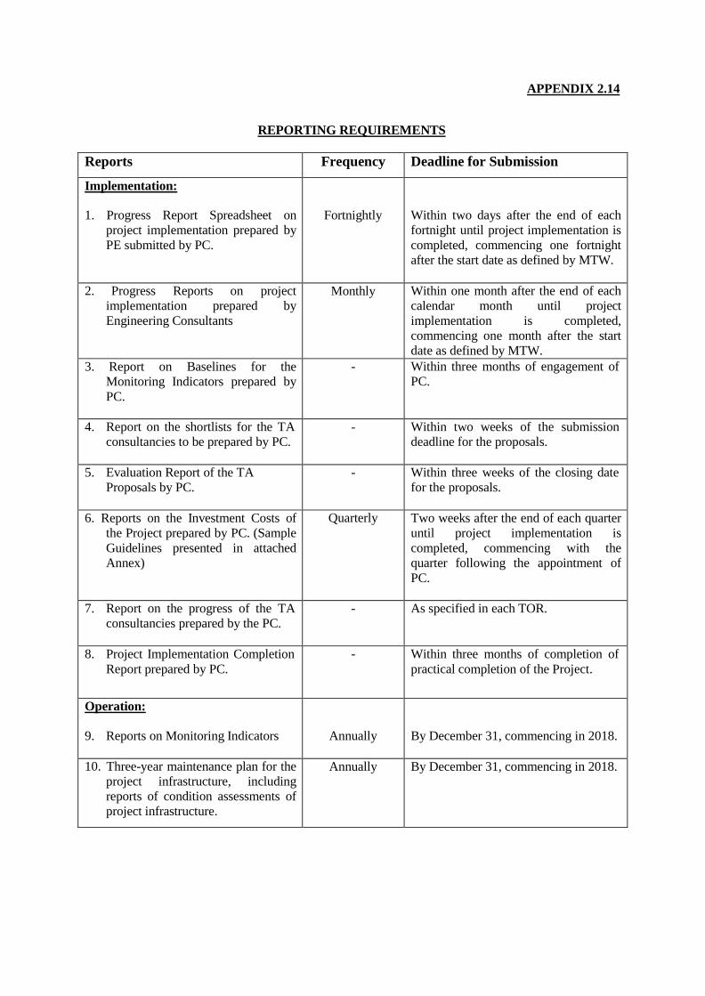
APPENDIX 2.14
REPORTING REQUIREMENTS
Reports Frequency Deadline for Submission
Implementation: 1. Progress Report Spreadsheet on
project implementation prepared by
PE submitted by PC.
Fortnightly
Within two days after the end of each
fortnight until project implementation is
completed, commencing one fortnight
after the start date as defined by MTW.
2. Progress Reports on project
implementation prepared by
Engineering Consultants
Monthly Within one month after the end of each
calendar month until project
implementation is completed,
commencing one month after the start
date as defined by MTW.
3. Report on Baselines for the
Monitoring Indicators prepared by
PC.
- Within three months of engagement of
PC.
4. Report on the shortlists for the TA
consultancies to be prepared by PC. - Within two weeks of the submission
deadline for the proposals.
5. Evaluation Report of the TA
Proposals by PC.
- Within three weeks of the closing date
for the proposals.
6. Reports on the Investment Costs of
the Project prepared by PC. (Sample
Guidelines presented in attached
Annex)
Quarterly Two weeks after the end of each quarter
until project implementation is
completed, commencing with the
quarter following the appointment of
PC.
7. Report on the progress of the TA
consultancies prepared by the PC.
- As specified in each TOR.
8. Project Implementation Completion
Report prepared by PC.
- Within three months of completion of
practical completion of the Project.
Operation:
9. Reports on Monitoring Indicators
Annually
By December 31, commencing in 2018.
10. Three-year maintenance plan for the
project infrastructure, including
reports of condition assessments of
project infrastructure.
Annually By December 31, commencing in 2018.

AN
NE
X T
O A
PP
EN
DIX
2.1
4
QUARTERLY REPORT ON INVESTMENT COST OF PROJECT
($'000)
Elements of Project
Expenditure
for this
Quarter
Cumulative
Expenditure
to date
Projected Expenditure
for the Quarter Estimated
Expenditure
to Complete
Project
Latest
Estimate of
Expenditure
Project
Estimate
as per
Appraisal
Report
Variance
Favourable/
(Adverse)
Comments/
Reasons for Adverse
Variance and
Financing Proposal to
Meet Cost Overrun Ending Ending Ending
(1) (2) (3) (4)1 (4)2 (4)3 (5) (6) (7) (8) (9)
1. Infrastructure 17,603
2. Services 7,098
Base Cost 24,701
3. Contingencies 4,664
4. Finance Charges1,279
Total Project Cost 30,644
USD Equivalent 11,350
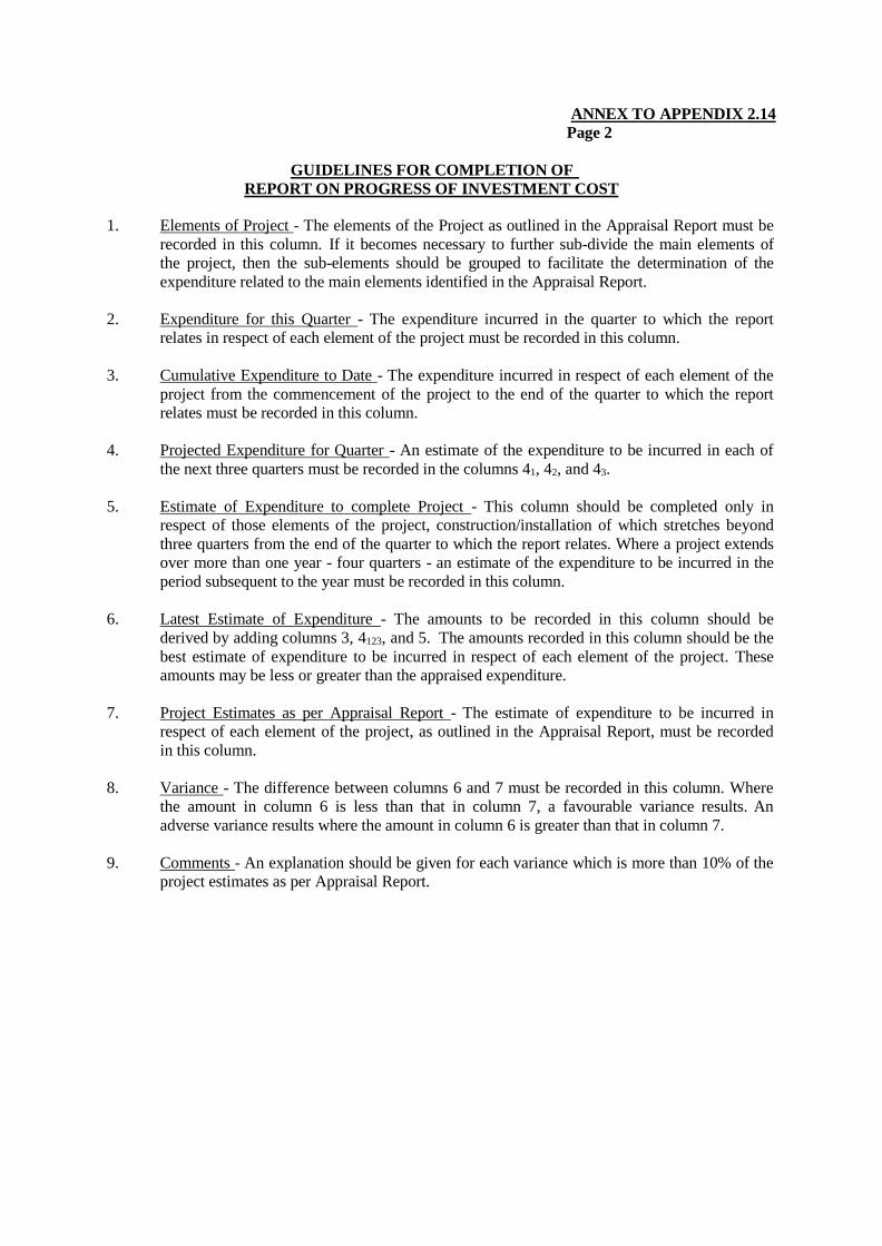
ANNEX TO APPENDIX 2.14
Page 2
GUIDELINES FOR COMPLETION OF
REPORT ON PROGRESS OF INVESTMENT COST
1. Elements of Project - The elements of the Project as outlined in the Appraisal Report must be
recorded in this column. If it becomes necessary to further sub-divide the main elements of
the project, then the sub-elements should be grouped to facilitate the determination of the
expenditure related to the main elements identified in the Appraisal Report.
2. Expenditure for this Quarter - The expenditure incurred in the quarter to which the report
relates in respect of each element of the project must be recorded in this column.
3. Cumulative Expenditure to Date - The expenditure incurred in respect of each element of the
project from the commencement of the project to the end of the quarter to which the report
relates must be recorded in this column.
4. Projected Expenditure for Quarter - An estimate of the expenditure to be incurred in each of
the next three quarters must be recorded in the columns 41, 42, and 43.
5. Estimate of Expenditure to complete Project - This column should be completed only in
respect of those elements of the project, construction/installation of which stretches beyond
three quarters from the end of the quarter to which the report relates. Where a project extends
over more than one year - four quarters - an estimate of the expenditure to be incurred in the
period subsequent to the year must be recorded in this column.
6. Latest Estimate of Expenditure - The amounts to be recorded in this column should be
derived by adding columns 3, 4123, and 5. The amounts recorded in this column should be the
best estimate of expenditure to be incurred in respect of each element of the project. These
amounts may be less or greater than the appraised expenditure.
7. Project Estimates as per Appraisal Report - The estimate of expenditure to be incurred in
respect of each element of the project, as outlined in the Appraisal Report, must be recorded
in this column.
8. Variance - The difference between columns 6 and 7 must be recorded in this column. Where
the amount in column 6 is less than that in column 7, a favourable variance results. An
adverse variance results where the amount in column 6 is greater than that in column 7.
9. Comments - An explanation should be given for each variance which is more than 10% of the
project estimates as per Appraisal Report.

APPENDIX 4.1
THE EXECUTING AGENCY FOR THE GRANT
1. LEGAL STATUS
1.1 CWSA was established by Section 3 of the Central Water and Sewerage Authority Act, 1991
(No. 17 of 1991) of SVG (the Act) to manage, construct, operate and maintain works in relation to the
supply of water and the disposal of sewage in SVG. CWSA is a body corporate with perpetual succession
and a common seal, with power to sue and to be sued in its corporate name, and to exercise such powers
and perform such duties as are conferred and imposed on it by the Act.
2. POWERS
2.1 The powers conferred by the Act with respect to the management of water and sewage include inter
alia the operation of facilities and equipment for the use, treatment, processing and disposal of waste; the
investigation of water resources and the consumption and demand of water. CWSA is also expressly
empowered, with the approval in writing of the Cabinet, to purchase by private treaty or compulsorily
acquire land in accordance with the Land Acquisition Act for any purpose connected with the discharge of
its functions.
3. MANAGEMENT
3.1 The powers of CWSA are exercised through the Board of Directors which is appointed by the
Minister and consists of a Chairman and Deputy Chairman, a representative from each of the following:
Ministry of Health; Ministry of Agriculture; a resident of Kingstown; a resident of a district other than
Kingstown; and a representative of the business community or hotel industry.
4. GOVERNMENT CONTROL
4.1 The Minister exercises control over the appointment of the members of the Board of Directors and
the remuneration payable to the members of the staff of CWSA. The Minister may, also, after consultation
with the Chairman of the Board of Directors, gives directions of a general or specific nature relating to the
policy to be followed by the Board of Directors in the performance of the functions of CWSA, and the
Board of Directors is required to give effect to such directions.
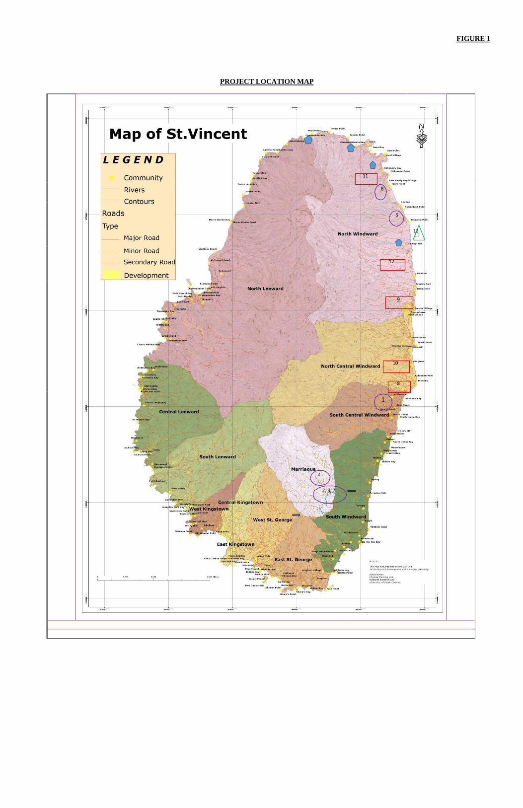
FIGURE 1
PROJECT LOCATION MAP
11
6
5
13
12
9
10
8
1
4
2, 3, 7

FIGURE 1
Page 2
Locations: Work Package 1 Work Package 2 Work Package 3
1. Union River Bridge – Windward Highway 2. Yambou River Bridge – Vigie Highway 3. Teviot and Zenga Bridges – Vigie Highway 4. Red Dog Bridge – Marriaqua District 5. Tourama – North Windward Highway 6. Magum – North Windward Highway 7. Glenside (Along the Yambou River) – Vigie Highway
8. River Defence: Yarabaqua River - Windward Highway 9. River Defence: Caratal River – North Windward district 10. Feeder Road: Gracefield Mountain Road – North Central District 11. Feeder Road: Roway Mountain Road – North Windward District 12. Feeder Road: Bower Mountain Road – North Windward District 13. Feeder Road: Ferguson Mountain Road – North Central District
14. Orange Hill – North Windward Highway
TA – Studies 1. LaCrox to Peruvian Vale (6km) – Vigie Highway
TA - Studies 2. Landslide Risk Assessment – Study Areas:[(i) Spring (ii) Orange Hill; (iii) Sandy Bay to Aqueduct; (iv) Roway to Point; (v) Owia; (vi) Bloody Bridge: (vii) Windblow; and (viii) Soldier Hill;]