Embed Size (px)
Citation preview
Department of Commerce · National Oceanic & Atmospheric Administration · National Weather Service
NATIONAL WEATHER SERVICE INSTRUCTION 10-502
JUNE 6, 2013
Operations and Services
Public Weather Services, NWSPD 10-5
NATIONAL STATEMENTS, SUMMARIES, TABLES PRODUCTS
SPECIFICATION
NOTICE: This publication is available at: http://www.nws.noaa.gov/directives/
OPR: W/OS22 (A. Noel)
Type of Issuance: Routine
Certified by: W/OS22 (E. Jacks)
SUMMARY OF REVISIONS: This instruction supersedes NWSI 10-502, “National
Statements, Summaries, Tables Products Specification”, dated November 5, 2010. The
following revisions were made to this instruction:
1) The Pan American Temperature and Precipitation Table product specification (Section 6) was
updated to reflect the name change of Tropical Prediction Center (TPC) to National Hurricane
Center (NHC).
2) The Storm Summaries product specification (Section 10) was updated to reflect the name
change of Hydrometeorological Prediction Center (HPC) to Weather Prediction Center (WPC).
_ _signed __ _____ ____5/23/13__________________
Christopher S. Strager Date
Acting Director, Office of Climate,
Water, and Weather Services
NWSI 10-502 June 6, 2013
2
National Statements, Summaries, Tables Products Specification
Table of Contents: Page
1. Introduction. ......................................................................................................................... 6
2. Hourly Temperature/Weather Summaries, United States {product categories
TPT (ERN,CRN,WRN)} ............................................................................................................... 6
2.1 Mission Connection ....................................................................................................... 6
2.2 Issuance Guidelines ........................................................................................................ 6
2.2.1 Creation Software ................................................................................................... 6
2.2.2 Issuance Criteria ...................................................................................................... 6
2.2.3 Issuance Time ......................................................................................................... 6
2.2.4 Valid Time .............................................................................................................. 6
2.2.5 Product Expiration Time ......................................................................................... 6
2.3 Technical Description .................................................................................................... 6
2.3.1 MND Broadcast Line .............................................................................................. 6
2.3.2 MND Header ........................................................................................................... 6
2.3.3 Content .................................................................................................................... 6
2.3.4 Format ..................................................................................................................... 7
2.4 Updates, Amendments, and Corrections ......................................................................... 8
3. Canadian Temperature and Precipitation Table (product category TPTCAN). ............ 8
3.1 Mission Connection ........................................................................................................ 8
3.2 Issuance Guidelines ......................................................................................................... 8
3.2.1 Creation Software ................................................................................................... 8
3.2.2 Issuance Criteria ...................................................................................................... 8
3.2.3 Issuance Time ......................................................................................................... 8
3.2.4 Valid Time .............................................................................................................. 8
3.2.5 Product Expiration Time ......................................................................................... 8
3.3 Technical Description ..................................................................................................... 8
3.3.1 MND Broadcast Line .............................................................................................. 8
3.3.2 MND Header ........................................................................................................... 8
3.3.3 Content .................................................................................................................... 8
3.3.4 Format ..................................................................................................................... 9
3.4 Updates, Amendments, and Corrections ......................................................................... 9
4. Mexican Weather Roundup (prod. category RWRMX, WMO Hdr ASMX46 KSGX) . 9
4.1 Mission Connection ........................................................................................................ 9
4.2 Issuance Guidelines ......................................................................................................... 9
4.2.1 Creation Software ................................................................................................... 9
4.2.2 Issuance Criteria ...................................................................................................... 9
4.2.3 Issuance Time ....................................................................................................... 10
4.2.4 Valid Time ............................................................................................................ 10
4.2.5 Product Expiration Time ....................................................................................... 10
4.3 Technical Description ................................................................................................... 10
NWSI 10-502 June 6, 2013
3
4.3.1 MND Broadcast Line ............................................................................................ 10
4.3.2 MND Header ......................................................................................................... 10
4.3.3 Content .................................................................................................................. 10
4.3.4 Format ................................................................................................................... 11
4.4 Updates, Amendments, and Corrections ....................................................................... 12
5. Latin America and Caribbean Hourly Weather Roundup (prod. category RWRMX,
WMO Header ASCA44 KEWX) ............................................................................................... 12
5.1 Mission Connection ...................................................................................................... 12
5.2 Issuance Guidelines ....................................................................................................... 12
5.2.1 Creation Software ................................................................................................. 12
5.2.2 Issuance Criteria .................................................................................................... 12
5.2.3 Issuance Time ....................................................................................................... 13
5.2.4 Valid Time ............................................................................................................ 13
5.2.5 Product Expiration Time ....................................................................................... 13
5.3 Technical Description ................................................................................................... 13
5.3.1 MND Broadcast Line ............................................................................................ 13
5.3.2 MND Header ......................................................................................................... 13
5.3.3 Content .................................................................................................................. 13
5.3.4 Format ................................................................................................................... 14
5.4 Updates, Amendments, and Corrections ....................................................................... 16
6. Pan American Temperature and Precipitation Table (product category TPTPAN) ... 16
6.1 Mission Connection ...................................................................................................... 16
6.2 Issuance Guidelines ....................................................................................................... 16
6.2.1 Creation Software ................................................................................................. 17
6.2.2 Issuance Criteria .................................................................................................... 17
6.2.3 Issuance Time ....................................................................................................... 17
6.2.4 Valid Time ............................................................................................................ 17
6.2.5 Product Expiration Time ....................................................................................... 17
6.3 Technical Description ................................................................................................... 17
6.3.1 MND Broadcast Line ............................................................................................ 17
6.3.2 MND Header ......................................................................................................... 17
6.3.3 Content .................................................................................................................. 17
6.3.4 Format ................................................................................................................... 17
6.4 Updates, Amendments, and Corrections ....................................................................... 18
7. Latin American Temperature and Weather Table (product category TPTLAT) ........ 18
7.1 Mission Connection ...................................................................................................... 18
7.2 Issuance Guidelines ....................................................................................................... 18
7.2.1 Creation Software ................................................................................................. 18
7.2.2 Issuance Criteria .................................................................................................... 18
7.2.3 Issuance Time ....................................................................................................... 18
7.2.4 Valid Time ............................................................................................................ 18
7.2.5 Product Expiration Time ....................................................................................... 18
7.3 Technical Description ................................................................................................... 18
NWSI 10-502 June 6, 2013
4
7.3.1 MND Broadcast Line ............................................................................................ 18
7.3.2 MND Header ......................................................................................................... 18
7.3.3 Content .................................................................................................................. 19
7.3.4 Format ................................................................................................................... 19
7.4 Updates, Amendments, and Corrections ....................................................................... 20
8. Hourly Temperature/Weather for North American Cities (prod. cat. TPTNAM) ....... 20
8.1 Mission Connection ...................................................................................................... 20
8.2 Issuance Guidelines ....................................................................................................... 20
8.2.1 Creation Software ................................................................................................. 20
8.2.2 Issuance Criteria .................................................................................................... 20
8.2.3 Issuance Time ....................................................................................................... 20
8.2.4 Valid Time ............................................................................................................ 20
8.2.5 Product Expiration Time ....................................................................................... 20
8.3 Technical Description ................................................................................................... 20
8.3.1 MND Broadcast Line ............................................................................................ 20
8.3.2 MND Header ......................................................................................................... 20
8.3.3 Content .................................................................................................................. 20
8.3.4 Format ................................................................................................................... 20
8.4 Updates, Amendments, and Corrections ....................................................................... 21
9. Foreign Temperature and Weather Table (product category TPTINT) ....................... 21
9.1 Mission Connection ...................................................................................................... 21
9.2 Issuance Guidelines ....................................................................................................... 21
9.2.1 Creation Software ................................................................................................. 21
9.2.2 Issuance Criteria .................................................................................................... 21
9.2.3 Issuance Time ....................................................................................................... 21
9.2.4 Valid Time ............................................................................................................ 21
9.2.5 Product Expiration Time ....................................................................................... 21
9.3 Technical Description ................................................................................................... 21
9.3.1 MND Broadcast Line ............................................................................................ 21
9.3.2 MND Header ......................................................................................................... 21
9.3.3 Content .................................................................................................................. 22
9.3.4 Format ................................................................................................................... 22
9.4 Updates, Amendments, and Corrections ....................................................................... 23
10. Storm Summaries (product categories SCCNS1-5) ..................................................... 23
10.1 Mission Connection ...................................................................................................... 23
10.2 Issuance Guidelines ....................................................................................................... 23
10.2.1 Creation Software ................................................................................................. 23
10.2.2 Issuance Criteria .................................................................................................... 23
10.2.3 Issuance Time ....................................................................................................... 23
10.2.4 Valid Time ............................................................................................................ 24
10.2.5 Product Expiration Time ....................................................................................... 24
10.3 Technical Description ................................................................................................... 24
10.3.1 MND Broadcast Line ............................................................................................ 24
NWSI 10-502 June 6, 2013
5
10.3.2 MND Header ......................................................................................................... 24
10.3.3 Content .................................................................................................................. 24
10.3.4 Format ................................................................................................................... 24
10.4 Updates, Amendments, and Corrections ....................................................................... 27
NWSI 10-502 June 6, 2013
6
1. Introduction. This procedural instruction describes various tables and summaries of
national and international interest. The products are generated by the NWS Telecommunication
Operations Center, the National Centers for Environmental Prediction (NCEP), and selected
NWS Weather Forecast Offices.
2. Hourly Temperature/Weather Summaries, United States {product categories TPT
(ERN, CRN, WRN)}
2.1 Mission Connection. These products contain the latest weather conditions and
temperatures for selected United States cities. Separate hourly collectives are issued for cities in
the eastern, central, and western United States. These products are for general public use
domestically and internationally.
2.2 Issuance Guidelines.
2.2.1 Creation Software. TPT (ERN, CRN, WRN) collectives are automatically compiled by
the National Weather Service Telecommunications Gateway (NWSTG) software.
2.2.2 Issuance Criteria. These are routine, scheduled products.
2.2.3 Issuance Time. TPT (ERN, CRN, WRN) collectives are generated hourly and
transmitted by approximately 30 minutes past the hour.
2.2.4 Valid Time. These products are valid upon transmission.
2.2.5 Product Expiration Time. Products expire with the next issuance.
2.3 Technical Description. The TPT (ERN, CRN, WRN) collectives will follow the format
and content described in this section.
2.3.1 MND Broadcast Line. Not applicable.
2.3.2 MND Header. The MND Headers for TPT (ERN, CRN, WRN) are:
“HOURLY TEMPERATURE/WEATHER FOR EASTERN UNITED STATES,” “HOURLY
TEMPERATURE/WEATHER FOR CENTRAL UNITED STATES,” and “HOURLY
TEMPERATURE/WEATHER FOR WESTERN UNITED STATES,” respectively.
2.3.3 Content. TPT (ERN, CRN, WRN) provide general weather conditions and
temperatures in degrees Fahrenheit (°F) and degrees Celsius (°C), every hour for selected cities
in United States. Specific cities for the eastern United States collective (TPTERN) are listed
below in the product example. Cities in the other two collectives are listed below the example.
NWSI 10-502 June 6, 2013
7
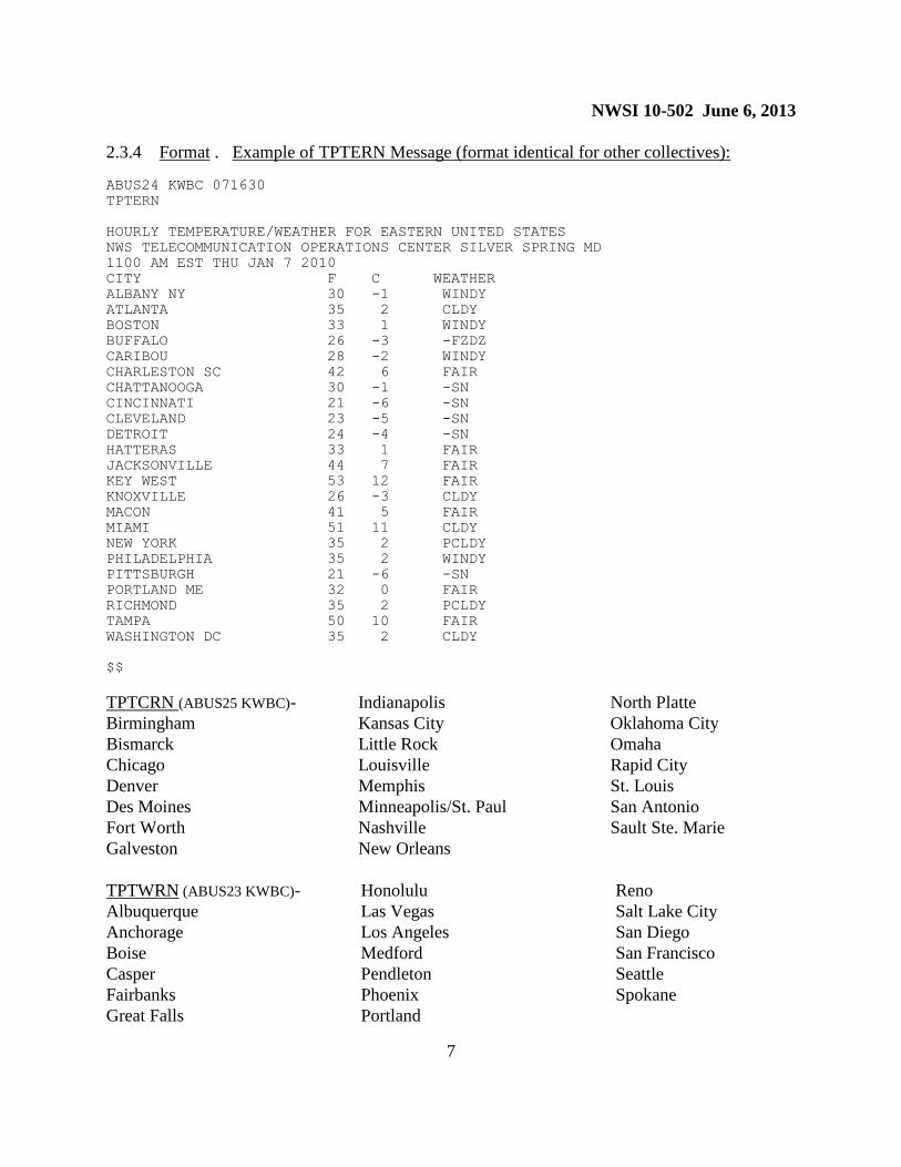
2.3.4 Format . Example of TPTERN Message (format identical for other collectives):
ABUS24 KWBC 071630
TPTERN
HOURLY TEMPERATURE/WEATHER FOR EASTERN UNITED STATES
NWS TELECOMMUNICATION OPERATIONS CENTER SILVER SPRING MD
1100 AM EST THU JAN 7 2010
CITY F C WEATHER
ALBANY NY 30 -1 WINDY
ATLANTA 35 2 CLDY
BOSTON 33 1 WINDY
BUFFALO 26 -3 -FZDZ
CARIBOU 28 -2 WINDY
CHARLESTON SC 42 6 FAIR
CHATTANOOGA 30 -1 -SN
CINCINNATI 21 -6 -SN
CLEVELAND 23 -5 -SN
DETROIT 24 -4 -SN
HATTERAS 33 1 FAIR
JACKSONVILLE 44 7 FAIR
KEY WEST 53 12 FAIR
KNOXVILLE 26 -3 CLDY
MACON 41 5 FAIR
MIAMI 51 11 CLDY
NEW YORK 35 2 PCLDY
PHILADELPHIA 35 2 WINDY
PITTSBURGH 21 -6 -SN
PORTLAND ME 32 0 FAIR
RICHMOND 35 2 PCLDY
TAMPA 50 10 FAIR
WASHINGTON DC 35 2 CLDY
$$
TPTCRN (ABUS25 KWBC)-
Birmingham
Bismarck
Chicago
Denver
Des Moines
Fort Worth
Galveston
Indianapolis
Kansas City
Little Rock
Louisville
Memphis
Minneapolis/St. Paul
Nashville
New Orleans
North Platte
Oklahoma City
Omaha
Rapid City
St. Louis
San Antonio
Sault Ste. Marie
TPTWRN (ABUS23 KWBC)-
Albuquerque
Anchorage
Boise
Casper
Fairbanks
Great Falls
Honolulu
Las Vegas
Los Angeles
Medford
Pendleton
Phoenix
Portland
Reno
Salt Lake City
San Diego
San Francisco
Seattle
Spokane

NWSI 10-502 June 6, 2013
8
2.4 Updates, Amendments, and Corrections . These products are not updated or amended.
Corrections are made as necessary.
3. Canadian Temperature and Precipitation Table (product category TPTCAN).
3.1 Mission Connection. This product contains highest and lowest temperatures, precipitation
amounts, and the current weather for selected Canadian cities. It provides general weather
conditions two times per day for general public use domestically and internationally.
3.2 Issuance Guidelines.
3.2.1 Creation Software. TPTCAN is automatically compiled and transmitted by the NWSTG.
3.2.2 Issuance Criteria. This is a routine, scheduled product.
3.2.3 Issuance Time. TPTCAN is transmitted twice daily at about 0200 and 1400 UTC.
3.2.4 Valid Time. The product is valid upon transmission.
3.2.5 Product Expiration Time. The product expires with the next issuance.
3.3 Technical Description. The TPTCAN will follow the format and content described in
this section.
3.3.1 MND Broadcast Line. Not applicable.
3.3.2 MND Header. The MND Header for TPTCAN is “CANADIAN TEMPERATURE
AND PRECIPITATION TABLE”
3.3.3 Content. TPTCAN provides general weather conditions at either 0000 UTC or 1200
UTC, high and low temperatures in degrees Fahrenheit (°F) and degrees Celsius (°C), and
observed precipitation (in millimeters) for the last 24 hours for selected cities in Canada. The
morning product contains the highest temperature for the previous day and the lowest
temperature in the last 12 hours. The evening product contains the highest temperature for the
last 12 hours and the lowest temperature during the last 18 hours. Specific cities are listed below
in the product example.
NWSI 10-502 June 6, 2013
9
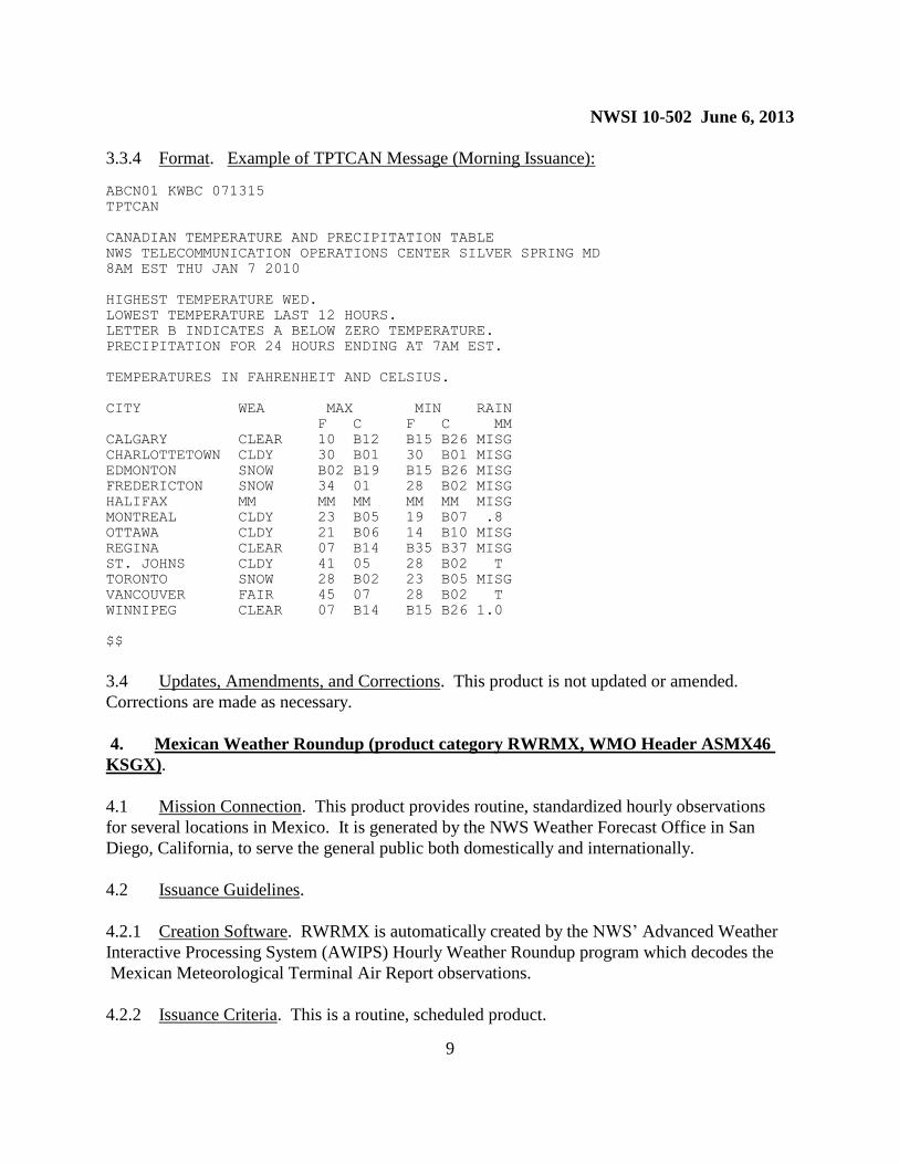
3.3.4 Format. Example of TPTCAN Message (Morning Issuance):
ABCN01 KWBC 071315
TPTCAN
CANADIAN TEMPERATURE AND PRECIPITATION TABLE
NWS TELECOMMUNICATION OPERATIONS CENTER SILVER SPRING MD
8AM EST THU JAN 7 2010
HIGHEST TEMPERATURE WED.
LOWEST TEMPERATURE LAST 12 HOURS.
LETTER B INDICATES A BELOW ZERO TEMPERATURE.
PRECIPITATION FOR 24 HOURS ENDING AT 7AM EST.
TEMPERATURES IN FAHRENHEIT AND CELSIUS.
CITY WEA MAX MIN RAIN
F C F C MM
CALGARY CLEAR 10 B12 B15 B26 MISG
CHARLOTTETOWN CLDY 30 B01 30 B01 MISG
EDMONTON SNOW B02 B19 B15 B26 MISG
FREDERICTON SNOW 34 01 28 B02 MISG
HALIFAX MM MM MM MM MM MISG
MONTREAL CLDY 23 B05 19 B07 .8
OTTAWA CLDY 21 B06 14 B10 MISG
REGINA CLEAR 07 B14 B35 B37 MISG
ST. JOHNS CLDY 41 05 28 B02 T
TORONTO SNOW 28 B02 23 B05 MISG
VANCOUVER FAIR 45 07 28 B02 T
WINNIPEG CLEAR 07 B14 B15 B26 1.0
$$
3.4 Updates, Amendments, and Corrections. This product is not updated or amended.
Corrections are made as necessary.
4. Mexican Weather Roundup (product category RWRMX, WMO Header ASMX46
KSGX).
4.1 Mission Connection. This product provides routine, standardized hourly observations
for several locations in Mexico. It is generated by the NWS Weather Forecast Office in San
Diego, California, to serve the general public both domestically and internationally.
4.2 Issuance Guidelines.
4.2.1 Creation Software. RWRMX is automatically created by the NWS’ Advanced Weather
Interactive Processing System (AWIPS) Hourly Weather Roundup program which decodes the
Mexican Meteorological Terminal Air Report observations.
4.2.2 Issuance Criteria. This is a routine, scheduled product.

NWSI 10-502 June 6, 2013
10
4.2.3 Issuance Time. RWRMX is transmitted approximately 10-15 minutes after the hour.
4.2.4 Valid Time. This product is valid upon transmission.
4.2.5 Product Expiration Time. The product expires with the next issuance.
4.3 Technical Description. RWRMX will follow the format and content described in this
section.
4.3.1 MND Broadcast Line. Not applicable.
4.3.2 MND Header. The MND Header for RWRMX is: “MEXICAN WEATHER
ROUNDUP.”
4.3.3 Content. The Mexican Weather Roundup is broken out by regions within Mexico (e.g.,
Baja California, Western Mexico, Yucatan Peninsula). RWRMX is set up to only report cities
which are received. The product contains the following elements for each location: general
sky/weather conditions; air temperature (°F); dew point temperature (°F); relative humidity;
wind direction (N, NE, E, SE, S, SW, W, or NW) and speed in miles per hour; barometric
pressure (inches of mercury) and pressure tendency, as applicable; and general remarks (e.g., fog,
haze, horizontal visibility, wind chill/heat indices, etc.). As long as an observation is available
the following cities may be contained in RWRMX:
Acapulco
Aguascalientes
B. De Huatulco
C. Del Carmen
Cabo
Campeche
Cancun
Chetumal
Chihuahua
Ciud. Victoria
Ciudad Juarez
Colima
Cozumel
Cuernavaca
Culiacan
Del Baji
Durango
Guadalajara
Guaymas
Hermosillo
Juarez
La Paz
Leon
Loreto
Los Cabos
Los Mochis
Manzanillo
Matamoros
Mazatlan
Merida
Mexicali
Mexico City
Morelia
Minatitlan
Monclova
Monterrey
Morelia
Nuevo Laredo
Oaxaca
Obregon
P. Escondido
Piedras Negras
Poza Rica
Pto. Escondido
Pto. Vallarta
Puebla
Queretaro
Reynosa
S. J. Del Cabo
S. Luis Potosi
Saltillo
San Lucas
Santa Rosalia
Tampico
Tapachula
Tepic
Tijuana
Toluca
Torreon
Tux. Gutierrez
Uruapan
Veracruz
Victoria
Villahermosa
Zacatecas
Zihuatanejo

NWSI 10-502 June 6, 2013
11
4.3.4 Format. Example of RWRMX Message:
ASMX46 KSGX 071610
RWRMX
MEXICAN WEATHER ROUNDUP
NATIONAL WEATHER SERVICE SAN DIEGO CA
800 AM PST THU JAN 07 2010
BAJA CALIFORNIA
CITY SKY/WX TMP DP RH WIND PRES REMARKS
ENSENADA NW N/A 52 32 45 CALM 29.92F
LA PAZ PTSUNNY 54 43 66 S5 30.03R
LORETO MOSUNNY 61 46 59 SW6 30.00S
MEXICALI MOSUNNY 48 39 71 CALM 29.97S
S.J. DEL CABO PTSUNNY 57 50 77 NW3 30.02R
S PEDRO MARTIR N/A 40 4 22 CALM N/A
TIJUANA MOSUNNY 54 39 58 SE6 30.04S
NORTHWESTERN MEXICO
CITY SKY/WX TMP DP RH WIND PRES REMARKS
CHIHUAHUA MOSUNNY 45 23 42 SW5 30.18R
CULIACAN CLOUDY 64 59 82 CALM 29.99R
GUAYMAS SUNNY 55 45 67 CALM 30.01R
HERMOSILLO MOSUNNY 50 27 40 CALM 30.03R
JUAREZ MOSUNNY 30 30 100 E21 30.20S WCI 17
LOS MOCHIS PTSUNNY 57 54 88 CALM 29.99S
OBREGON SUNNY 61 39 44 CALM 29.98R
NORTHEASTERN MEXICO
CITY SKY/WX TMP DP RH WIND PRES REMARKS
MATAMOROS PTSUNNY 66 61 82 SW9 30.10R
MONCLOVA CLOUDY 45 43 93 NE22 30.23R HAZE
MONTERREY PTSUNNY 54 48 82 NW12G25 30.16R
NUEVO LAREDO CLOUDY 52 48 87 N14G25 30.26R
PIEDRAS NEGRAS PTSUNNY 43 34 70 NW35G40 30.42R
REYNOSA PTSUNNY 59 55 88 NW9 30.14R
SALTILLO MOSUNNY 59 36 41 CALM 30.19R
TORREON PTSUNNY 54 34 47 SE6 30.17R
VICTORIA PTSUNNY 59 54 82 N5 30.12R
WESTERN MEXICO
CITY SKY/WX TMP DP RH WIND PRES REMARKS
AGUASCALIENTES CLOUDY 48 41 76 N7 30.21R FOG
COLIMA CLOUDY 72 55 56 CALM 30.06R
DURANGO PTSUNNY 45 32 61 CALM 30.25R
GUADALAJARA CLOUDY 54 48 82 CALM 30.21R
MANZANILLO PTSUNNY 77 68 73 N6 29.93R
MAZATLAN CLOUDY 66 61 82 N8 29.96R
PTO. VALLARTA CLOUDY 70 61 73 CALM 29.98R
TEPIC CLOUDY 55 52 88 CALM 30.16R
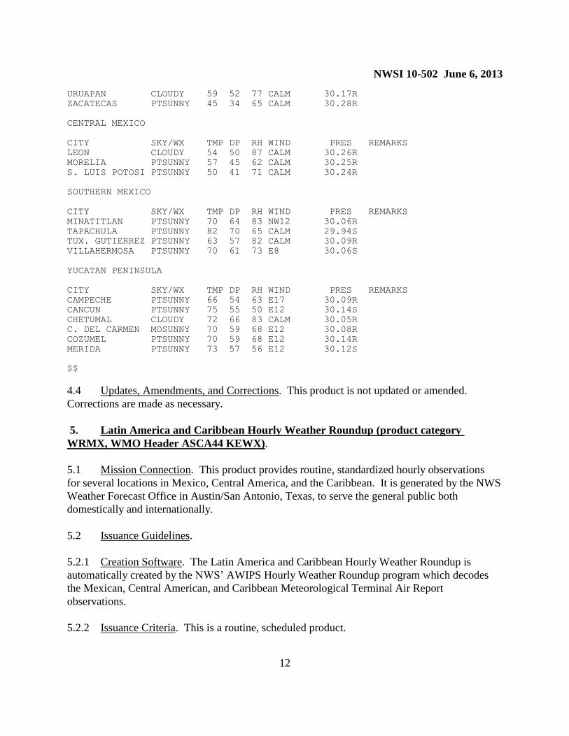
NWSI 10-502 June 6, 2013
12
URUAPAN CLOUDY 59 52 77 CALM 30.17R
ZACATECAS PTSUNNY 45 34 65 CALM 30.28R
CENTRAL MEXICO
CITY SKY/WX TMP DP RH WIND PRES REMARKS
LEON CLOUDY 54 50 87 CALM 30.26R
MORELIA PTSUNNY 57 45 62 CALM 30.25R
S. LUIS POTOSI PTSUNNY 50 41 71 CALM 30.24R
SOUTHERN MEXICO
CITY SKY/WX TMP DP RH WIND PRES REMARKS
MINATITLAN PTSUNNY 70 64 83 NW12 30.06R
TAPACHULA PTSUNNY 82 70 65 CALM 29.94S
TUX. GUTIERREZ PTSUNNY 63 57 82 CALM 30.09R
VILLAHERMOSA PTSUNNY 70 61 73 E8 30.06S
YUCATAN PENINSULA
CITY SKY/WX TMP DP RH WIND PRES REMARKS
CAMPECHE PTSUNNY 66 54 63 E17 30.09R
CANCUN PTSUNNY 75 55 50 E12 30.14S
CHETUMAL CLOUDY 72 66 83 CALM 30.05R
C. DEL CARMEN MOSUNNY 70 59 68 E12 30.08R
COZUMEL PTSUNNY 70 59 68 E12 30.14R
MERIDA PTSUNNY 73 57 56 E12 30.12S
$$
4.4 Updates, Amendments, and Corrections. This product is not updated or amended.
Corrections are made as necessary.
5. Latin America and Caribbean Hourly Weather Roundup (product category
WRMX, WMO Header ASCA44 KEWX).
5.1 Mission Connection. This product provides routine, standardized hourly observations
for several locations in Mexico, Central America, and the Caribbean. It is generated by the NWS
Weather Forecast Office in Austin/San Antonio, Texas, to serve the general public both
domestically and internationally.
5.2 Issuance Guidelines.
5.2.1 Creation Software. The Latin America and Caribbean Hourly Weather Roundup is
automatically created by the NWS’ AWIPS Hourly Weather Roundup program which decodes
the Mexican, Central American, and Caribbean Meteorological Terminal Air Report
observations.
5.2.2 Issuance Criteria. This is a routine, scheduled product.
NWSI 10-502 June 6, 2013
13
5.2.3 Issuance Time. The Latin America and Caribbean Hourly Weather Roundup is
transmitted approximately 10-15 minutes after the hour.
5.2.4 Valid Time. This product is valid upon transmission.
5.2.5 Product Expiration Time. The product expires with the next issuance.
5.3 Technical Description. The Latin America and Caribbean Hourly Weather Roundup will
follow the format and content described in this section.
5.3.1 MND Broadcast Line. Not applicable.
5.3.2 MND Header. The MND Header for this product is: “LATIN AMERICA AND
CARIBBEAN HOURLY WEATHER ROUNDUP.”
5.3.3 Content. In addition to selected locations in Central America and the Caribbean, the
Latin America and Caribbean Hourly Weather Roundup is broken out by regions within Mexico
(e.g., Baja California, Western Mexico, Yucatan Peninsula). The product is set up to only report
locations which are received. The roundup contains the following elements for each location:
general sky/weather conditions; air temperature (°F); dew point temperature (°F); relative
humidity; wind direction (N, NE, E, SE, S, SW, W, or NW) and speed in miles per hour;
barometric pressure (inches of mercury) and pressure tendency, as applicable; and general
remarks (e.g., fog, haze, horizontal visibility, wind chill/heat indices, etc.). As long as an
observation is available the following locations may be contained in the Latin America and
Caribbean Hourly Weather Roundup:
Central America:
Belize City, Belize
San Jose, Costa Rica
San Salvador, El Salvador
Guatemala City, Guatemala
Tegucigalpa, Honduras
Managua, Nicaragua
Panama City, Panama
Caribbean:
Aruba
Barbados
Grenada
Nassau, Bahamas
Port-Au-Prince, Haiti
San Juan, Puerto Rico
Santo Domingo, Dominican Republic
St. Croix, Virgin Islands (U.S.)
St. Kitts
St. Lucia
St. Maarten
St. Thomas, Virgin Islands (U.S.)
NWSI 10-502 June 6, 2013
14
Mexico:
Acapulco
Aguascalientes
C. Del Carmen
Cabo
Campeche
Cancun
Chetumal
Chihuahua
Ciud. Victoria
Colima
Cozumel
Cuernavaca
Culiacan
Del Bajio
Durango
Guadalajara
Guaymas
Hermosillo
Juarez
La Paz
Leon
Loreto
Los Cabos
Los Mochis
Manzanillo
Matamoros
Mazatlan
Merida
Mexicali
Mexico City
Morelia
Minatitlan
Monclova
Monterrey
Morelia
Nuevo Laredo
Oaxaca
Obregon
P. Escondido
Piedras Negras
Poza Rica
P. Vallarta
Puebla
Queretaro
Reynosa
S. Luis Potosi
Saltillo
San Lucas
Santa Rosalia
Tampico
Tapachula
Tepic
Tijuana
Toluca
Torreon
Tux. Gutierrez
Uruapan
Veracruz
Victoria
Villahermosa
Zacatecas
Zihuatanejo
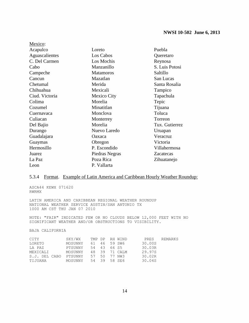
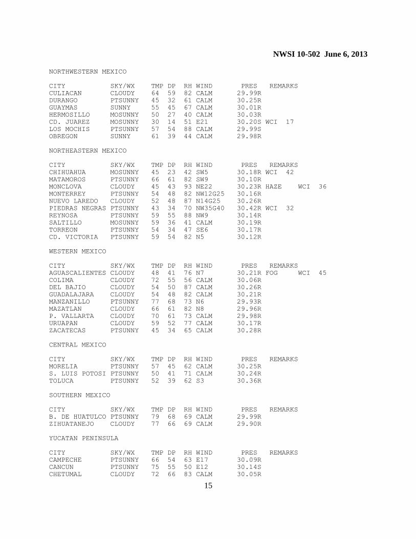
5.3.4 Format. Example of Latin America and Caribbean Hourly Weather Roundup:
ASCA44 KEWX 071620
RWRMX
LATIN AMERICA AND CARIBBEAN REGIONAL WEATHER ROUNDUP
NATIONAL WEATHER SERVICE AUSTIN/SAN ANTONIO TX
1000 AM CST THU JAN 07 2010
NOTE: "FAIR" INDICATED FEW OR NO CLOUDS BELOW 12,000 FEET WITH NO
SIGNIFICANT WEATHER AND/OR OBSTRUCTIONS TO VISIBILITY.
BAJA CALIFORNIA
CITY SKY/WX TMP DP RH WIND PRES REMARKS
LORETO MOSUNNY 61 46 59 SW6 30.00S
LA PAZ PTSUNNY 54 43 66 S5 30.03R
MEXICALI MOSUNNY 48 39 71 CALM 29.97S
S.J. DEL CABO PTSUNNY 57 50 77 NW3 30.02R
TIJUANA MOSUNNY 54 39 58 SE6 30.04S
NWSI 10-502 June 6, 2013
15
NORTHWESTERN MEXICO
CITY SKY/WX TMP DP RH WIND PRES REMARKS
CULIACAN CLOUDY 64 59 82 CALM 29.99R
DURANGO PTSUNNY 45 32 61 CALM 30.25R
GUAYMAS SUNNY 55 45 67 CALM 30.01R
HERMOSILLO MOSUNNY 50 27 40 CALM 30.03R
CD. JUAREZ MOSUNNY 30 14 51 E21 30.20S WCI 17
LOS MOCHIS PTSUNNY 57 54 88 CALM 29.99S
OBREGON SUNNY 61 39 44 CALM 29.98R
NORTHEASTERN MEXICO
CITY SKY/WX TMP DP RH WIND PRES REMARKS
CHIHUAHUA MOSUNNY 45 23 42 SW5 30.18R WCI 42
MATAMOROS PTSUNNY 66 61 82 SW9 30.10R
MONCLOVA CLOUDY 45 43 93 NE22 30.23R HAZE WCI 36
MONTERREY PTSUNNY 54 48 82 NW12G25 30.16R
NUEVO LAREDO CLOUDY 52 48 87 N14G25 30.26R
PIEDRAS NEGRAS PTSUNNY 43 34 70 NW35G40 30.42R WCI 32
REYNOSA PTSUNNY 59 55 88 NW9 30.14R
SALTILLO MOSUNNY 59 36 41 CALM 30.19R
TORREON PTSUNNY 54 34 47 SE6 30.17R
CD. VICTORIA PTSUNNY 59 54 82 N5 30.12R
WESTERN MEXICO
CITY SKY/WX TMP DP RH WIND PRES REMARKS
AGUASCALIENTES CLOUDY 48 41 76 N7 30.21R FOG WCI 45
COLIMA CLOUDY 72 55 56 CALM 30.06R
DEL BAJIO CLOUDY 54 50 87 CALM 30.26R
GUADALAJARA CLOUDY 54 48 82 CALM 30.21R
MANZANILLO PTSUNNY 77 68 73 N6 29.93R
MAZATLAN CLOUDY 66 61 82 N8 29.96R
P. VALLARTA CLOUDY 70 61 73 CALM 29.98R
URUAPAN CLOUDY 59 52 77 CALM 30.17R
ZACATECAS PTSUNNY 45 34 65 CALM 30.28R
CENTRAL MEXICO
CITY SKY/WX TMP DP RH WIND PRES REMARKS
MORELIA PTSUNNY 57 45 62 CALM 30.25R
S. LUIS POTOSI PTSUNNY 50 41 71 CALM 30.24R
TOLUCA PTSUNNY 52 39 62 S3 30.36R
SOUTHERN MEXICO
CITY SKY/WX TMP DP RH WIND PRES REMARKS
B. DE HUATULCO PTSUNNY 79 68 69 CALM 29.99R
ZIHUATANEJO CLOUDY 77 66 69 CALM 29.90R
YUCATAN PENINSULA
CITY SKY/WX TMP DP RH WIND PRES REMARKS
CAMPECHE PTSUNNY 66 54 63 E17 30.09R
CANCUN PTSUNNY 75 55 50 E12 30.14S
CHETUMAL CLOUDY 72 66 83 CALM 30.05R
NWSI 10-502 June 6, 2013
16
CD. DEL CARMEN MOSUNNY 70 59 68 E12 30.08R
COZUMEL PTSUNNY 70 59 68 E12 30.14R
MERIDA PTSUNNY 73 57 56 E12 30.12S
MINATITLAN PTSUNNY 70 64 83 NW12 30.06R
TAPACHULA PTSUNNY 82 70 65 CALM 29.94S
TUX. GUTIERREZ PTSUNNY 63 57 82 CALM 30.09R
VILLAHERMOSA PTSUNNY 70 61 73 E8 30.06S
CENTRAL AMERICA
CITY SKY/WX TMP DP RH WIND PRES REMARKS
BELIZE CITY HVY RAIN 66 66 100 SW5 30.08S VSB 5/8
GUATEMALA CITY PTSUNNY 64 52 63 N14 30.30S
MANAGUA MOSUNNY 82 61 47 E23 29.92S
SAN JOSE N/A 79 59 50 E12 30.02S
SAN SALVADOR N/A 84 57 39 N5 29.92S
TEGUCIGALPA PTSUNNY 68 57 68 N13 30.15
CARIBBEAN
CITY SKY/WX TMP DP RH WIND PRES REMARKS
ARUBA MOSUNNY 90 73 58 E22 29.92S HX 98
ANTIGUA MOSUNNY 86 68 54 SE9 30.00S
BARBADOS N/A 86 68 54 E20 29.97S
CURACAO MOSUNNY 86 73 66 E15 29.92S HX 93
GRAND CAYMAN PTSUNNY 73 61 64 E15 30.12S
GRENADA MOSUNNY 84 72 65 SE23 29.97S
MONTEGO BAY MOSUNNY 81 66 61 E15 30.03
NASSAU PTSUNNY 66 50 55 NE6 30.23R
PORT-AU-PRINCE MOSUNNY 82 64 54 E14 30.03
SAN JUAN RAIN 75 73 94 NE5 30.06F FOG
ST. CROIX MOSUNNY 82 72 69 S7 30.03F
ST. LUCIA PTSUNNY 82 72 69 SE16 30.00S
ST. THOMAS MOSUNNY 79 72 78 NE8 30.03F
TRINIDAD MOSUNNY 84 66 54 E16 29.97F
$$
5.4 Updates, Amendments, and Corrections. This product is not updated or amended.
Corrections are made as necessary.
6. Pan American Temperature and Precipitation Table (product category TPTPAN).
6.1 Mission Connection. This is a collection of temperature and precipitation data for
selected cities in Mexico, Central and South America, and the Caribbean area. It provides
general weather conditions two times per day for general public use domestically and
internationally.
6.2 Issuance Guidelines.
NWSI 10-502 June 6, 2013
17
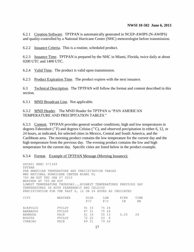
6.2.1 Creation Software. TPTPAN is automatically generated in NCEP-AWIPS (N-AWIPS)
and quality-controlled by a National Hurricane Center (NHC) meteorologist before transmission.
6.2.2 Issuance Criteria. This is a routine, scheduled product.
6.2.3 Issuance Time. TPTPAN is prepared by the NHC in Miami, Florida, twice daily at about
0200 UTC and 1400 UTC.
6.2.4 Valid Time. The product is valid upon transmission.
6.2.5 Product Expiration Time. The product expires with the next issuance.
6.3 Technical Description. The TPTPAN will follow the format and content described in this
section.
6.3.1 MND Broadcast Line. Not applicable.
6.3.2 MND Header. The MND Header for TPTPAN is “PAN AMERICAN
TEMPERATURE AND PRECIPITATION TABLES.”
6.3.3 Content. TPTPAN provides general weather conditions, high and low temperatures in
degrees Fahrenheit (°F) and degrees Celsius (°C), and observed precipitation in either 6, 12, or
24 hours, as indicated, for selected cities in Mexico, Central and South America, and the
Caribbean area. The morning product contains the low temperature for the current day and the
high temperature from the previous day. The evening product contains the low and high
temperature for the current day. Specific cities are listed below in the product example.
6.3.4 Format. Example of TPTPAN Message (Morning Issuance):
SXCA01 KNHC 071349
TPTPAN
PAN AMERICAN TEMPERATURE AND PRECIPITATION TABLES
NWS NATIONAL HURRICANE CENTER MIAMI FL
700 AM EST THU JAN 07 2010
WEATHER AT 700 AM EST
LOWEST TEMPERATURE THURSDAY...HIGHEST TEMPERATURES PREVIOUS DAY
TEMPERATURES IN BOTH FAHRENHEIT AND CELSIUS
PRECIPITATION FOR THE PAST 6, 12 OR 24 HOURS AS INDICATED
CITY WEATHER HIGH LOW PCPN TIME
F/C F/C IN HR
ACAPULCO PTCLDY 91 33 75 24
BARBADOS PTCLDY 87 31 75 24
BERMUDA FAIR 61 16 55 13 0.03 24
BOGOTA PTCLDY 72 22 43 6
CURACAO FAIR 89 31 79 26

NWSI 10-502 June 6, 2013
18
FREEPORT PTCLDY MM MM MM MM
GUADALAJARA PTCLDY 73 23 49 9
GUADELOUPE FAIR 85 30 69 21 0.10 24
HAVANA PTCLDY 67 20 61 16
KINGSTON FAIR 84 29 72 22
MAZATLAN FAIR 82 28 59 15
MERIDA PTCLDY 73 23 63 17
MEXICO CITY PTCLDY 66 19 48 9
MONTEGO BAY PTCLDY 76 24 73 23 TRACE 24
MONTERREY FAIR 44 6 45 7
NASSAU PTCLDY 66 19 58 14
SAN JUAN PR RAIN 88 31 74 23 0.01 24
ST THOMAS RAIN 83 28 73 23
TEGUCIGALPA FAIR 71 22 59 15
TRINIDAD FAIR 90 32 73 23 TRACE 24
VERACRUZ FAIR 70 21 63 17
$$
6.4 Updates, Amendments, and Corrections. This product is not updated or amended.
Corrections are made as necessary.
7. Latin American Temperature and Weather Table (product category TPTLAT).
7.1 Mission Connection. This is a collection of observed weather conditions and
temperatures at 0000 UTC and 1200 UTC for selected cities in Mexico, Central and South
America, and the Caribbean. This product is for general public use domestically and
internationally.
7.2 Issuance Guidelines.
7.2.1 Creation Software. TPTLAT is automatically compiled by NWSTG software.
7.2.2 Issuance Criteria. This is a routine, scheduled product.
7.2.3 Issuance Time. TPTLAT is transmitted approximately two hours after observation time.
7.2.4 Valid Time. This product is valid upon transmission.
7.2.5 Product Expiration Time. Product expires with the next issuance.
7.3 Technical Description. TPTLAT will follow the format and content described in this
section.
7.3.1 MND Broadcast Line. Not applicable.
7.3.2 MND Header. The MND Header for TPTLAT is: “LATIN AMERICAN TEMP AND
NWSI 10-502 June 6, 2013
19
WEATHER TABLE.”
7.3.3 Content. TPTLAT provides general weather conditions and temperatures in degrees
Fahrenheit (°F) and degrees Celsius (°C) twice daily for selected cities in Latin America.
Specific cities for the product are listed below in the product example.
7.3.4 Format. Example of TPTLAT Message:
ABXX07 KWBC 071200
TPTLAT
LATIN AMERICAN TEMP AND WEATHER TABLE
NWS TELECOMMUNICATION OPERATIONS CENTER SILVER SPRING MD
1200 UTC THU JAN 7 2010
PRESENT LOCAL TEMPS
CITY WEATHER TIME F C
ANTIGUA FAIR 8AM 77 25
ASUNCION PTCLDY 8AM 81 27
BELIZE CITY RAIN 6AM 66 19
BOGOTA CLDY 7AM 48 9
BRIDGETOWN RAIN 8AM 77 25
BUENOS AIRES FAIR 9AM 68 20
CARACAS PTCLDY 8AM 75 24
CAYENNE FAIR 9AM 82 28
GEORGETOWN 8AM NO DATA
GUATEMALA CITY MISTY 6AM MM MM
HAVANA CLDY 7AM 55 13
KINGSTON FAIR 7AM 73 23
LA PAZ CLDY 8AM 46 8
LIMA CLDY 7AM 70 21
MANAGUA FAIR 6AM 75 24
MEXICO CITY CLDY 6AM 48 9
MONTEVIDEO FAIR 9AM 68 20
PANAMA CITY HAZE 6AM 77 25
PARAMARIBO FAIR 8AM 77 25
PORT AU PRINCE FAIR 8AM MM MM
PORT OF SPAIN FAIR 8AM 79 26
QUITO FOG 7AM 48 9
RIO DE JANEIRO FAIR 9AM 88 31
SAINT THOMAS RAIN 8AM 75 24
SAN JOSE PTCLDY 6AM 70 21
SAN JUAN RAIN 8AM 75 24
SAN SALVADOR FAIR 6AM 63 17
SANTIAGO FAIR 8AM 66 19
SANTO DOMINGO FAIR 7AM 68 20
SAO PAULO FAIR 9AM 73 23
TEGUCIGALPA PTCLDY 6AM 59 15
$$
NWSI 10-502 June 6, 2013
20
7.4 Updates, Amendments, and Corrections. This product is not updated or amended.
Corrections are made as necessary.
8. Hourly Temperature/Weather for North American Cities (product category
TPTNAM).
8.1 Mission Connection. This product contains the current temperature and
abbreviations/symbols for the weather for selected North American cities. The product is
intended for general public use domestically and internationally.
8.2 Issuance Guidelines.
8.2.1 Creation Software. TPTNAM is automatically compiled by the NWSTG.
8.2.2 Issuance Criteria. This is a routine, scheduled product.
8.2.3 Issuance Time. TPTNAM is transmitted approximately 30 minutes after observation
time.
8.2.4 Valid Time. This product is valid upon transmission.
8.2.5 Product Expiration Time. Product expires with the next issuance.
8.3 Technical Description. TPTNAM will follow the format and content described in
this section.
8.3.1 MND Broadcast Line. Not applicable.
8.3.2 MND Header. The MND Header for TPTNAM is:“HOURLY TEMPERATURE/
WEATHER FOR NORTH AMERICAN CITIES.”
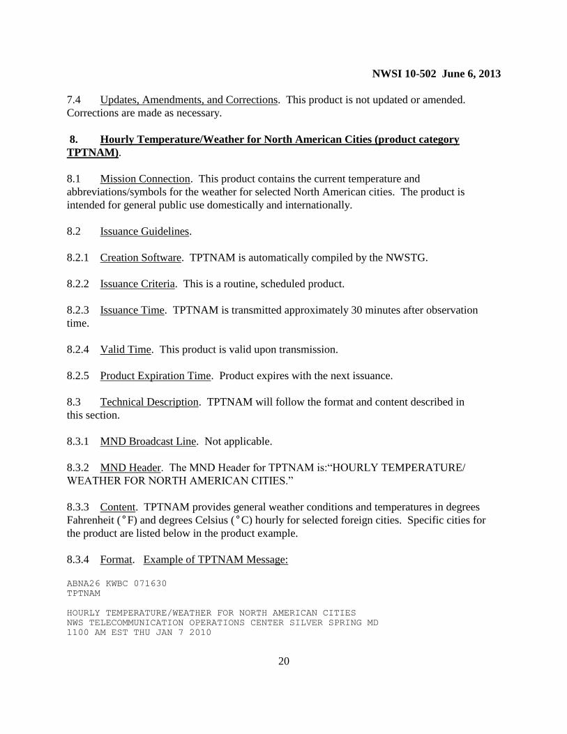
8.3.3 Content. TPTNAM provides general weather conditions and temperatures in degrees
Fahrenheit (°F) and degrees Celsius (°C) hourly for selected foreign cities. Specific cities for
the product are listed below in the product example.
8.3.4 Format. Example of TPTNAM Message:
ABNA26 KWBC 071630
TPTNAM
HOURLY TEMPERATURE/WEATHER FOR NORTH AMERICAN CITIES
NWS TELECOMMUNICATION OPERATIONS CENTER SILVER SPRING MD
1100 AM EST THU JAN 7 2010
NWSI 10-502 June 6, 2013
21
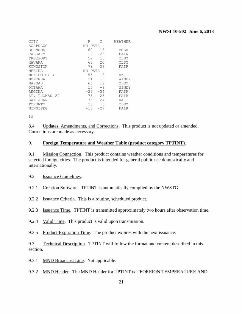
CITY F C WEATHER
ACAPULCO NO DATA
BERMUDA 60 16 VCSH
CALGARY -9 -23 FAIR
FREEPORT 59 15 CLDY
HAVANA 68 20 CLDY
KINGSTON 78 26 FAIR
MERIDA NO DATA
MEXICO CITY 55 13 HZ
MONTREAL 21 -6 WINDY
NASSAU 66 19 CLDY
OTTAWA 15 -9 WINDY
REGINA -29 -34 FAIR
ST. THOMAS VI 78 26 FAIR
SAN JUAN 75 24 RA
TORONTO 23 -5 CLDY
WINNIPEG -16 -27 FAIR
$$
8.4 Updates, Amendments, and Corrections. This product is not updated or amended.
Corrections are made as necessary.
9. Foreign Temperature and Weather Table (product category TPTINT).
9.1 Mission Connection. This product contains weather conditions and temperatures for
selected foreign cities. The product is intended for general public use domestically and
internationally.
9.2 Issuance Guidelines.
9.2.1 Creation Software. TPTINT is automatically compiled by the NWSTG.
9.2.2 Issuance Criteria. This is a routine, scheduled product.
9.2.3 Issuance Time. TPTINT is transmitted approximately two hours after observation time.
9.2.4 Valid Time. This product is valid upon transmission.
9.2.5 Product Expiration Time. The product expires with the next issuance.
9.3 Technical Description. TPTINT will follow the format and content described in this
section.
9.3.1 MND Broadcast Line. Not applicable.
9.3.2 MND Header. The MND Header for TPTINT is: “FOREIGN TEMPERATURE AND
NWSI 10-502 June 6, 2013
22
WEATHER TABLE”.
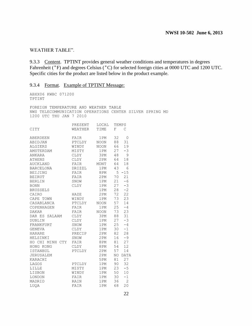
9.3.3 Content. TPTINT provides general weather conditions and temperatures in degrees
Fahrenheit (°F) and degrees Celsius (°C) for selected foreign cities at 0000 UTC and 1200 UTC.
Specific cities for the product are listed below in the product example.
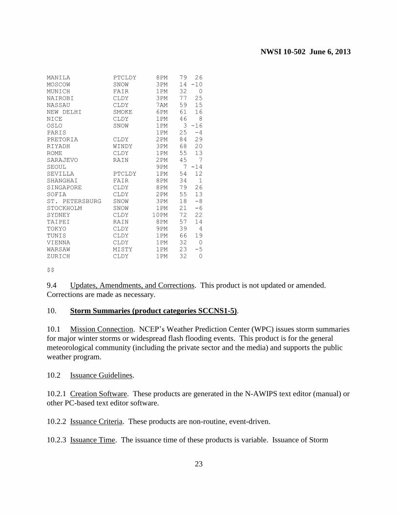
9.3.4 Format. Example of TPTINT Message:
ABXX06 KWBC 071200
TPTINT
FOREIGN TEMPERATURE AND WEATHER TABLE
NWS TELECOMMUNICATION OPERATIONS CENTER SILVER SPRING MD
1200 UTC THU JAN 7 2010
PRESENT LOCAL TEMPS
CITY WEATHER TIME F C
ABERDEEN FAIR 1PM 32 0
ABIDJAN PTCLDY NOON 88 31
ALGIERS WINDY NOON 66 19
AMSTERDAM MISTY 1PM 27 -3
ANKARA CLDY 3PM 48 9
ATHENS CLDY 2PM 64 18
AUCKLAND FAIR MDNT 64 18
BARCELONA DRIZZL 1PM 43 6
BEIJING FAIR 8PM 5 -15
BEIRUT FAIR 2PM 70 21
BERLIN SNOW 1PM 21 -6
BONN CLDY 1PM 27 -3
BRUSSELS 1PM 28 -2
CAIRO HAZE 2PM 72 22
CAPE TOWN WINDY 1PM 73 23
CASABLANCA PTCLDY NOON 57 14
COPENHAGEN FAIR 1PM 25 -4
DAKAR FAIR NOON 73 23
DAR ES SALAAM CLDY 3PM 88 31
DUBLIN CLDY 1PM 27 -3
FRANKFURT SNOW 1PM 25 -4
GENEVA CLDY 1PM 30 -1
HARARE PRECIP 2PM 82 28
HELSINKI SNOW 2PM 16 -9
HO CHI MINH CTY FAIR 8PM 81 27
HONG KONG CLDY 8PM 54 12
ISTANBUL PTCLDY 2PM 57 14
JERUSALEM 2PM NO DATA
KARACHI 5PM 81 27
LAGOS PTCLDY 1PM 90 32
LILLE MISTY 1PM 23 -5
LISBON WINDY 1PM 50 10
LONDON FAIR 1PM 30 -1
MADRID RAIN 1PM 36 2
LUQA FAIR 1PM 68 20
NWSI 10-502 June 6, 2013
23
MANILA PTCLDY 8PM 79 26
MOSCOW SNOW 3PM 14 -10
MUNICH FAIR 1PM 32 0
NAIROBI CLDY 3PM 77 25
NASSAU CLDY 7AM 59 15
NEW DELHI SMOKE 6PM 61 16
NICE CLDY 1PM 46 8
OSLO SNOW 1PM 3 -16
PARIS 1PM 25 -4
PRETORIA CLDY 2PM 84 29
RIYADH WINDY 3PM 68 20
ROME CLDY 1PM 55 13
SARAJEVO RAIN 2PM 45 7
SEOUL 9PM 7 -14
SEVILLA PTCLDY 1PM 54 12
SHANGHAI FAIR 8PM 34 1
SINGAPORE CLDY 8PM 79 26
SOFIA CLDY 2PM 55 13
ST. PETERSBURG SNOW 3PM 18 -8
STOCKHOLM SNOW 1PM 21 -6
SYDNEY CLDY 10PM 72 22
TAIPEI RAIN 8PM 57 14
TOKYO CLDY 9PM 39 4
TUNIS CLDY 1PM 66 19
VIENNA CLDY 1PM 32 0
WARSAW MISTY 1PM 23 -5
ZURICH CLDY 1PM 32 0
$$
9.4 Updates, Amendments, and Corrections. This product is not updated or amended.
Corrections are made as necessary.
10. Storm Summaries (product categories SCCNS1-5).
10.1 Mission Connection. NCEP’s Weather Prediction Center (WPC) issues storm summaries
for major winter storms or widespread flash flooding events. This product is for the general
meteorological community (including the private sector and the media) and supports the public
weather program.
10.2 Issuance Guidelines.
10.2.1 Creation Software. These products are generated in the N-AWIPS text editor (manual) or
other PC-based text editor software.
10.2.2 Issuance Criteria. These products are non-routine, event-driven.
10.2.3 Issuance Time. The issuance time of these products is variable. Issuance of Storm
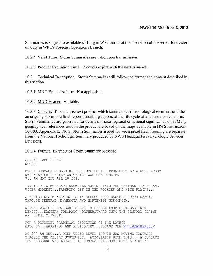
NWSI 10-502 June 6, 2013
24
Summaries is subject to available staffing in WPC and is at the discretion of the senior forecaster
on duty in WPC's Forecast Operations Branch.
10.2.4 Valid Time. Storm Summaries are valid upon transmission.
10.2.5 Product Expiration Time. Products expire with the next issuance.
10.3 Technical Description. Storm Summaries will follow the format and content described in
this section.
10.3.1 MND Broadcast Line. Not applicable.
10.3.2 MND Header. Variable.
10.3.3 Content. This is a free text product which summarizes meteorological elements of either
an ongoing storm or a final report describing aspects of the life cycle of a recently ended storm.
Storm Summaries are generated for events of major regional or national significance only. Many
geographical references used in the product are based on the maps available in NWS Instruction
10-503, Appendix E. Note: Storm Summaries issued for widespread flash flooding are separate
from the National Hydrologic Summary produced by NWS Headquarters (Hydrologic Services
Division).
10.3.4 Format. Example of Storm Summary Message.
ACUS42 KWBC 180830
SCCNS2
STORM SUMMARY NUMBER 08 FOR ROCKIES TO UPPER MIDWEST WINTER STORM
NWS WEATHER PREDICTION CENTER COLLEGE PARK MD
300 AM MDT THU APR 18 2013
...LIGHT TO MODERATE SNOWFALL MOVING INTO THE CENTRAL PLAINS AND
UPPER MIDWEST...TAPERING OFF IN THE ROCKIES AND HIGH PLAINS...
A WINTER STORM WARNING IS IN EFFECT FROM EASTERN SOUTH DAKOTA
THROUGH CENTRAL MINNESOTA AND NORTHWEST WISCONSIN.
WINTER WEATHER ADVISORIES ARE IN EFFECT FROM NORTHEAST NEW
MEXICO...EASTERN COLORADO NORTHEASTWARD INTO THE CENTRAL PLAINS
AND UPPER MIDWEST.
FOR A DETAILED GRAPHICAL DEPICTION OF THE LATEST
WATCHES...WARNINGS AND ADVISORIES...PLEASE SEE WWW.WEATHER.GOV
AT 200 AM MDT...A DEEP UPPER LEVEL TROUGH WAS MOVING EASTWARD
THROUGH THE DESERT SOUTHWEST. ASSOCIATED WITH THIS... A SURFACE
LOW PRESSURE WAS LOCATED IN CENTRAL MISSOURI WITH A CENTRAL
NWSI 10-502 June 6, 2013
25
PRESSURE OF 1001 MB... 29.56 INCHES. NATIONAL WEATHER SERVICE
DOPPLER RADARS AND SURFACE OBSERVATIONS INDICATED A NARROW SWATH
OF LIGHT TO MODERATE SNOW FALLING FROM WESTERN KANSAS
NORTHEASTWARD INTO CENTRAL NEBRASKA. FARTHER NORTH...AN AREA OF
LIGHT SNOW WAS AFFECTING NORTHERN MINNESOTA AND WISCONSIN. FROM
THE SURFACE LOW IN CENTRAL MISSOURI...A SLOW MOVING COLD FRONT IS
PUSHING THROUGH THE CENTRAL AND SOUTHERN PLAINS WITH A LINE OF
STRONG THUNDERSTORMS AND HEAVY RAIN JUST AHEAD OF THE FRONT. A
WARM FRONT EXTENDS INTO THE OHIO VALLEY WITH A LARGE AREA OF HEAVY
RAINFALL TO THE NORTH OF THE BOUNDARY.
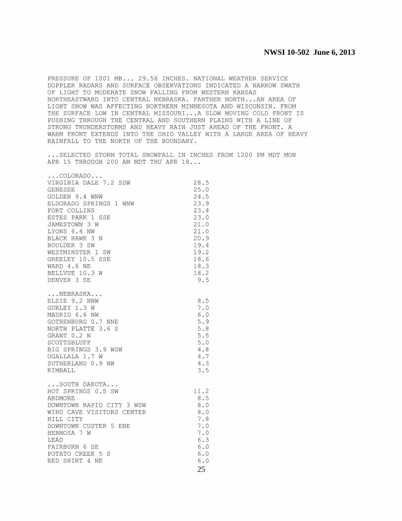
...SELECTED STORM TOTAL SNOWFALL IN INCHES FROM 1200 PM MDT MON
APR 15 THROUGH 200 AM MDT THU APR 18...
...COLORADO...
VIRGINIA DALE 7.2 SSW 28.5
GENESEE 25.0
GOLDEN 9.4 WNW 24.5
ELDORADO SPRINGS 1 WNW 23.9
FORT COLLINS 23.4
ESTES PARK 1 SSE 23.0
JAMESTOWN 3 W 21.0
LYONS 6.4 NW 21.0
BLACK HAWK 3 N 20.9
BOULDER 3 SW 19.4
WESTMINSTER 1 SW 19.2
GREELEY 10.5 SSE 18.6
WARD 4.6 NE 18.3
BELLVUE 10.3 W 18.2
DENVER 3 SE 9.5
...NEBRASKA...
ELSIE 9.2 NNW 8.5
GURLEY 1.3 W 7.0
MADRID 6.6 NW 6.0
GOTHENBURG 0.7 NNE 5.9
NORTH PLATTE 3.6 S 5.8
GRANT 0.2 N 5.5
SCOTTSBLUFF 5.0
BIG SPRINGS 3.9 WSW 4.8
OGALLALA 1.7 W 4.7
SUTHERLAND 0.9 NW 4.3
KIMBALL 3.5
...SOUTH DAKOTA...
HOT SPRINGS 0.5 SW 11.2
ARDMORE 8.5
DOWNTOWN RAPID CITY 3 WSW 8.0
WIND CAVE VISITORS CENTER 8.0
HILL CITY 7.8
DOWNTOWN CUSTER 5 ENE 7.0
HERMOSA 7 W 7.0
LEAD 6.3
FAIRBURN 6 SE 6.0
POTATO CREEK 5 S 6.0
RED SHIRT 4 NE 6.0
NWSI 10-502 June 6, 2013
26
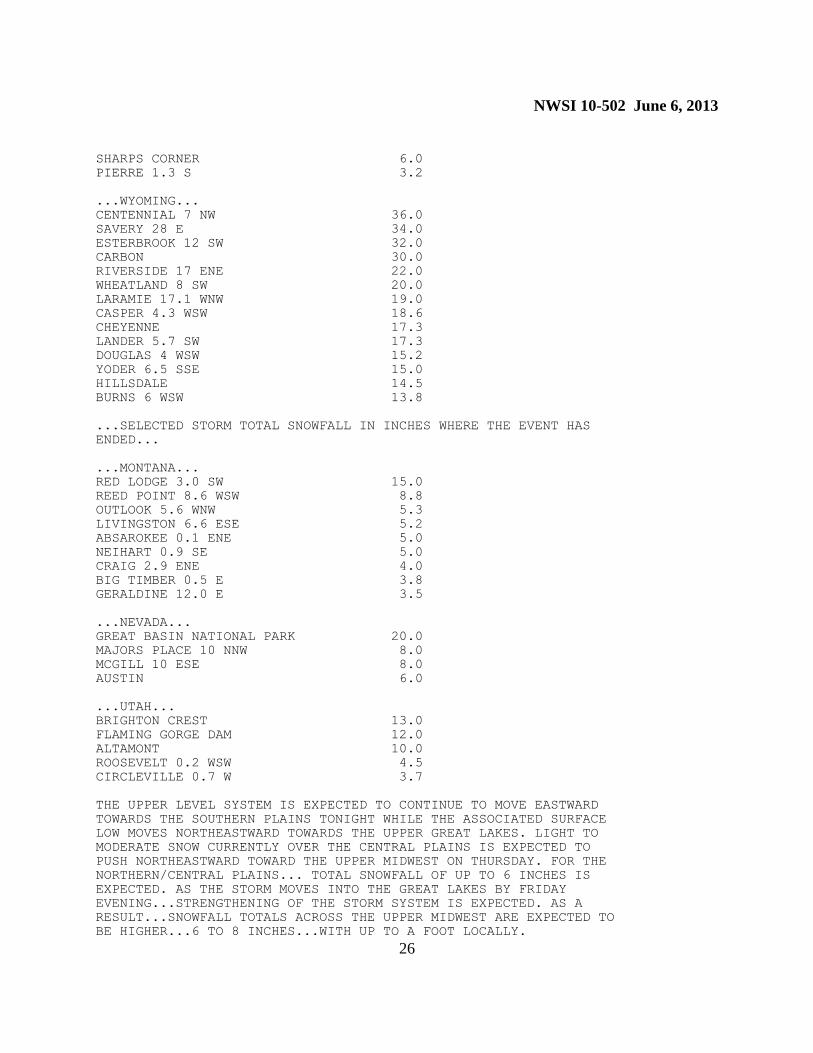
SHARPS CORNER 6.0
PIERRE 1.3 S 3.2
...WYOMING...
CENTENNIAL 7 NW 36.0
SAVERY 28 E 34.0
ESTERBROOK 12 SW 32.0
CARBON 30.0
RIVERSIDE 17 ENE 22.0
WHEATLAND 8 SW 20.0
LARAMIE 17.1 WNW 19.0
CASPER 4.3 WSW 18.6
CHEYENNE 17.3
LANDER 5.7 SW 17.3
DOUGLAS 4 WSW 15.2
YODER 6.5 SSE 15.0
HILLSDALE 14.5
BURNS 6 WSW 13.8
...SELECTED STORM TOTAL SNOWFALL IN INCHES WHERE THE EVENT HAS
ENDED...
...MONTANA...
RED LODGE 3.0 SW 15.0
REED POINT 8.6 WSW 8.8
OUTLOOK 5.6 WNW 5.3
LIVINGSTON 6.6 ESE 5.2
ABSAROKEE 0.1 ENE 5.0
NEIHART 0.9 SE 5.0
CRAIG 2.9 ENE 4.0
BIG TIMBER 0.5 E 3.8
GERALDINE 12.0 E 3.5
...NEVADA...
GREAT BASIN NATIONAL PARK 20.0
MAJORS PLACE 10 NNW 8.0
MCGILL 10 ESE 8.0
AUSTIN 6.0
...UTAH...
BRIGHTON CREST 13.0
FLAMING GORGE DAM 12.0
ALTAMONT 10.0
ROOSEVELT 0.2 WSW 4.5
CIRCLEVILLE 0.7 W 3.7
THE UPPER LEVEL SYSTEM IS EXPECTED TO CONTINUE TO MOVE EASTWARD
TOWARDS THE SOUTHERN PLAINS TONIGHT WHILE THE ASSOCIATED SURFACE
LOW MOVES NORTHEASTWARD TOWARDS THE UPPER GREAT LAKES. LIGHT TO
MODERATE SNOW CURRENTLY OVER THE CENTRAL PLAINS IS EXPECTED TO
PUSH NORTHEASTWARD TOWARD THE UPPER MIDWEST ON THURSDAY. FOR THE
NORTHERN/CENTRAL PLAINS... TOTAL SNOWFALL OF UP TO 6 INCHES IS
EXPECTED. AS THE STORM MOVES INTO THE GREAT LAKES BY FRIDAY
EVENING...STRENGTHENING OF THE STORM SYSTEM IS EXPECTED. AS A
RESULT...SNOWFALL TOTALS ACROSS THE UPPER MIDWEST ARE EXPECTED TO
BE HIGHER...6 TO 8 INCHES...WITH UP TO A FOOT LOCALLY.

NWSI 10-502 June 6, 2013
27
THE NEXT STORM SUMMARY WILL BE ISSUED BY THE WEATHER PREDICTION
CENTER AT 900 AM MDT. PLEASE REFER TO YOUR LOCAL NATIONAL WEATHER
SERVICE OFFICE FOR ADDITIONAL INFORMATION ON THIS EVENT.
KREKELER
$$
10.4 Updates, Amendments, and Corrections. Storm Summaries are not updated or amended.
WPC will issue corrections as necessary.

![EG Robotics Arduino Weather Station Instruction …ARDUINO WEATHER STATION INSTRUCTION MANUAL] EG Robotics Manual | Interested LLC 2013 | 1 | Page EG Robotics Arduino Weather Station](https://img.dokumen.tips/doc/110x75/5ab679477f8b9a1a048dc925/eg-robotics-arduino-weather-station-instruction-arduino-weather-station-instruction.jpg)