Embed Size (px)
Citation preview

Planning Act 2008 Infrastructure Planning The Infrastructure Planning (Applications: Prescribed Forms and Procedure) Regulations 2009 Regulation Number: S56 Author: A30 Temple to Higher Carblake Improvement
Team, Cornwall Council Document Reference: TRXCP311/PA/NVC/01
PI Reference TR010014 Document Date Version Note 29 July2014 0 First Issue
National Vegetation Classification Assessment 2014

Issue & Revision Record
Revision Date Author Purpose of Issue / Nature of
Change 0 29/07/2014 CM First Issue
This document has been prepared for the titled project or named part thereof and should not be relied upon or used for any other project without an independent check being carried out as to its suitability and prior written authority of Cornwall Council being obtained. Cornwall Council accepts no responsibility or liability for the consequences of this document being used for a purpose other than the purposes for which it was commissioned. Any person using or relying on the document for such other purposes agrees, and will by such use or reliance be taken to confirm his agreement to indemnify Cornwall Council for all loss or damage resulting therefrom. Cornwall Council accepts no responsibility or liability for this document to any party other than the person by whom it was commissioned.

National Vegetation ClassificationAssessment 2014; A30 Temple to
Carblake, Cornwall.
A30 NVC Assesment 2014 Final_v3 Prepared by Parsons BrinckerhoffJuly 2014 for Cornwall Council
- 7 -
CONTENTSPage
Executive Summary 9
Introduction 11
1 Introduction 131.1 Background 131.2 Site Context 13
Methodology 15
2 Methodology 172.1 Previous NVC assessment 172.2 Further NVC assessments 172.3 Survey limitations 19
Results 21
3 Results 223.1 Previous assessment results 223.2 Site walkover 223.3 Species richness 233.4 Heathland indicator species 233.5 NVC results 243.6 Results summary and options appraisal 28
Discussion, Recommendations and Management Plan 29
4 Discussion and Management Plan 314.1 Discussion 314.2 Favourable condition assessment of the dominant M25b habitat 334.3 Management plan 41
Figures 45
Appendix A – SSSI Citation 47
Appendix B – Constancy Tables 49


National Vegetation ClassificationAssessment 2014; A30 Temple to
Carblake, Cornwall.
A30 NVC Assesment 2014 Final_v3 Prepared by Parsons BrinckerhoffJuly 2014 for Cornwall Council
- 9 -
EXECUTIVE SUMMARY
Introduction Parsons Brinckerhoff Ltd. was commissioned by Cornwall Council to carry outan Ecological Assessment as part of an Environmental Statement to support aplanning application to upgrade the existing A30 Temple to Higher Carblakesection from single carriageway to dual carriageway, in Cornwall.
As part of the ecological assessment the unavoidable permanent loss of 0.39Ha of the Bodmin Moor North Site of Special Scientific Interest was identified inorder to facilitate the installation of the new road junction. Therefore an area ofhabitat adjacent to the SSSI was proposed to be acquired and managed asSSSI. This report documents the results of National Vegetation Classification(NVC) surveys, recommends an area for replacement and details amanagement plan for that area.
Methodology NVC surveys were carried out on the area of SSSI being lost in June 2012(Parsons Brinkerhoff, 2012), and subsequently on the two proposedReplacement Areas (MC Option A and Option M5) in June 2014. The surveyfollowed standard methodology; whereby areas of distinct vegetation typeswere recorded and quadrats deployed in each of these. Plant speciesobserved within each habitat type and quadrat were recorded with theirabundance.
The data collected was analysed using both keys devised by Rodwell 1991and using a computer statistical package.
Results The site walkover identified that the Option M5 held the more diverse mosaicof habitats and those most affiliated with Bodmin Moor North SSSI and thearea of habitat to be lost as part of the road widening.
NVC survey results identified similar habitats within both proposedreplacement habitats with M25b Molinia caerulea – Potentilla erecta mireAnthoxanthum odoratum sub-community dominating the habitats present.
M25b habitats recorded in Option M5 held a higher species diversity andcontained more heathland indicator species. Further, U4 grassland habitatswere recorded within edge habitats of the M25b pasture.
The combination of the above assessment works and options appraisal haveidentified Option M5 as the preferred option for the Replacement Area. Afavourable condition assessment was undertaken which established that theM25b habitats in Option M5 are in unfavourable condition. In accordance withthe condition assessment of the SSSI unit containing the area to be lost,currently the SSSI is also in unfavourable condition but recovering.
Management andMonitoring Plan
The conservation objectives for the Replacement Area include maintenanceand management of the M25 habitats and clearance of encroaching scrub.The management plan includes a period of initial vegetation clearance works.This includes removal of encroaching scrub and planted coniferous trees fromwithin the Replacement Area.It is recommended that summer grazing be introduced into the ReplacementArea, this will result in the selective grazing of MG10a and M23 habitats overM25b pasture. This will result in increased M25b habitats and encourageericoids and heathland indicator species to establish in greater abundancewithin the sward.

National Vegetation ClassificationAssessment 2014; A30 Temple to
Carblake, Cornwall.
A30 NVC Assesment 2014 Final_v3July 2014
- 10 -

National Vegetation ClassificationAssessment 2014; A30 Temple to
Carblake, Cornwall.
A30 NVC Assesment 2014 Final_v3 Prepared by Parsons BrinckerhoffJuly 2014 for Cornwall Council
- 11 -
SECTION 1
INTRODUCTION

National Vegetation ClassificationAssessment 2014; A30 Temple to
Carblake, Cornwall.
A30 NVC Assesment 2014 Final_v3 Prepared by Parsons BrinckerhoffJuly 2014 for Cornwall Council
- 13 -
1 INTRODUCTION
1.1 Background
1.1.1 Parsons Brinckerhoff Ltd. was commissioned by Cornwall Council to carry outecological services to support and inform a planning application to upgrade theexisting A30 Temple to Higher Carblake section, Cornwall.
1.1.2 An initial Phase 1 Habitat Survey1 undertaken in 2012 highlighted that 0.39 ha of theBodmin Moor North Site of Special Scientific Interest (SSSI) would be potentially lostas a result of the proposed development. National Vegetation Classification(hereafter referred to as NVC) surveys were undertaken. The results of this initialNVC survey can be found in the initial NVC report2.
1.1.3 To replace the unavoidable permanent habitat loss of the Bodmin Moor North SSSIrequired to facilitate the installation of the new road junction an area of land adjacentto the SSSI was proposed to be acquired and managed as part of the SSSI. Acommon land supplementary report was produced, consultation undertaken and twopotential options were identified as viable for Replacement Areas; MC option A andOption M5.
1.1.4 This report documents the results of the NVC surveys carried out on the two areasproposed as Replacement Areas (MC Option A and Option M5), it details an optionsappraisal and includes a management plan and monitoring scheme for the preferredReplacement Area. The management plan is designed to maintain the ecologicalvalue and favourable conservation status of the Replacement Area with the aim forthe area to be included within Bodmin Moor North SSSI.
1.2 Site Context
1.2.1 The A30 is a major trunk road running through the centre of Cornwall from West toEast. The A30 forms one of the most important routes through the county of Cornwalland is under pressure during the summer months due to high numbers of tourists andthus it is proposed to widen the road from single carriageway to dual carriageway.The development will take place between grid references SX 10926 70830 Temple atthe western end and SX 13696 73695 Carblake at the eastern end.
1 Parsons Brinckerhoff April 2012; A30 Temple to Higher Carblake Phase 1 Habitat Survey, Report produced for CornwallCouncil2 Parsons Brinckerhoff August 2012: A30 Temple to Higher Carblake National Vegetation Classification Survey, reportproduced for Cornwall Council.


National Vegetation ClassificationAssessment 2014; A30 Temple to
Carblake, Cornwall.
A30 NVC Assesment 2014 Final_v3 Prepared by Parsons BrinckerhoffJuly 2014 for Cornwall Council
- 15 -
SECTION 2
METHODOLOGY


National Vegetation ClassificationAssessment 2014; A30 Temple to
Carblake, Cornwall.
A30 NVC Assesment 2014 Final_v3 Prepared by Parsons BrinckerhoffJuly 2014 for Cornwall Council
- 17 -
2 METHODOLOGY
2.1 Previous NVC assessment
2.1.1 An initial NVC assessment was undertaken on the area of SSSI which would bepermanently lost as per the development proposals on the 25th and 26th July 2012 bytwo suitably experienced ecologists. Methodologies followed for these works can befound within the initial NVC report3
2.2 Further NVC assessments
2.2.1 The further NVC assessments of the two areas proposed as Replacement Areaswere undertaken on the 10th June 2014 by a suitably experienced PB ecologist.
2.2.2 The survey followed standard methodology devised by Joint Nature ConservationCommittee (JNCC) NVC Users Handbook4. Plant species observed within eachhabitat type and quadrat were recorded in accordance with plant speciesnomenclature in Stace (2010)5.
2.2.3 The surveyor walked both survey areas and identified the different areas ofhomogenous vegetation present. The extents of these areas were then mapped andthe location areas subject to detailed sample survey was decided.
2.2.4 The size of the quadrat sample was chosen based on the NVC standard methodologywhere for short, herbaceous vegetation 2 x 2 m is the recommended quadrat size.The number of five samples was chosen as this is the lowest number of samples thatcan be taken to make further calculations easy. This is explained in more detailbelow.
MC Option A
2.2.5 Five 2 m x 2 m ground flora quadrat samples were marked out for eachrepresentative type of vegetation present within the grasslands; in this case shortersward grassland (survey locations shown on NVC map as G1 – G5) and miregrassland mosaic (M1 – M5).
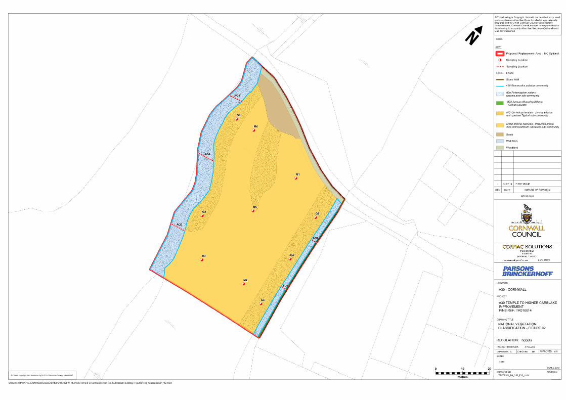
2.2.6 Five 2 m x 2 m aquatic quadrats were marked out along the wet ditches within MCoption A. These ditches were considered to support similar vegetative communitiesand were assessed as a single habitat. Within these quadrats three layers wererecorded separately, as per best practice; emergent vegetation, submerged and freefloating. The cross sections of the ditches surveyed are shown in the NVC maps asAQ1 – AQ5. Areas of scrub recorded were not surveyed separately due to theirlimited extent within the Replacement Area.
Option M5
2.2.7 Five 2 m x 2 m ground flora quadrat samples were marked out for eachrepresentative type of vegetation present within the grasslands; in this case recentlymown grassland (G1 – G5), mire grassland mosaic (M1 – M5) and marshy grassland(MG1 – MG5).
3 Parsons Brinckerhoff August 2012: A30 Temple to Higher Carblake National Vegetation Classification Survey, reportproduced for Cornwall Council.4 JNCC 2006; J.S. Rodwell, National Vegetation Classification User’s Handbook5 Stace, C. (2010) New Flora of the British Isles; Second Edition. Cambrid6ge University Press, Cambridge.
National Vegetation ClassificationAssessment 2014; A30 Temple to
Carblake, Cornwall.
A30 NVC Assesment 2014 Final_v3 Prepared by Parsons BrinckerhoffJuly 2014 for Cornwall Council
- 18 -
2.2.8 Five 2 m x 2 m aquatic quadrats were marked out along the wet ditches within OptionM5. These ditches were considered to support similar vegetative communities andwere assessed as a single habitat. Within these quadrats three layers were recordedseparately, as per best practice; emergent vegetation, submerged and free floating.The cross sections of the ditches surveyed are shown in the NVC maps as AQ1 –AQ5.
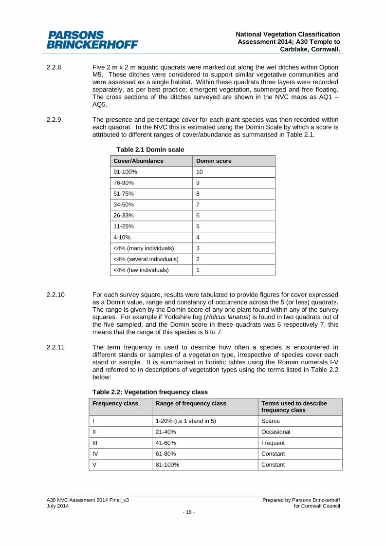
2.2.9 The presence and percentage cover for each plant species was then recorded withineach quadrat. In the NVC this is estimated using the Domin Scale by which a score isattributed to different ranges of cover/abundance as summarised in Table 2.1.
Table 2.1 Domin scaleCover/Abundance Domin score
91-100% 10
76-90% 9
51-75% 8
34-50% 7
26-33% 6
11-25% 5
4-10% 4
<4% (many individuals) 3
<4% (several individuals) 2
<4% (few individuals) 1
2.2.10 For each survey square, results were tabulated to provide figures for cover expressedas a Domin value, range and constancy of occurrence across the 5 (or less) quadrats.The range is given by the Domin score of any one plant found within any of the surveysquares. For example if Yorkshire fog (Holcus lanatus) is found in two quadrats out ofthe five sampled, and the Domin score in these quadrats was 6 respectively 7, thismeans that the range of this species is 6 to 7.
2.2.11 The term frequency is used to describe how often a species is encountered indifferent stands or samples of a vegetation type, irrespective of species cover eachstand or sample. It is summarised in floristic tables using the Roman numerals I-Vand referred to in descriptions of vegetation types using the terms listed in Table 2.2below:
Table 2.2: Vegetation frequency classFrequency class Range of frequency class Terms used to describe
frequency class
I 1-20% (i.e 1 stand in 5) Scarce
II 21-40% Occasional
III 41-60% Frequent
IV 61-80% Constant
V 81-100% Constant

National Vegetation ClassificationAssessment 2014; A30 Temple to
Carblake, Cornwall.
A30 NVC Assesment 2014 Final_v3 Prepared by Parsons BrinckerhoffJuly 2014 for Cornwall Council
- 19 -
2.2.12 At this stage of the classification the sample number comes into consideration. Giventhat five samples have been used it is easy to calculate in which frequency class anyof the species falls into.
2.2.13 This information was then used in conjunction with the key in British PlantCommunities Volume 3 Grasslands and Montane Communities6, British PlantCommunities Volume 2 Mires and Heaths7, British Plant Communities Volume 4Aquatic communities swamps and tall-herb fens8 to assign the most closelycorresponding NVC community type based on the range and frequency of plantspecies within each plot.
2.2.14 In addition to keying out the habitats present on site, Modular Analysis of VegetationInformation System (MAVIS)9 a computer statistical programme for analysingvegetation data was used to classify the habitats present on site.
2.3 Survey limitations
2.3.1 It must be noted that the site was visited over the period of a single day, as suchseasonal variations were not observed and potentially only a selection of all speciesthat occur within the site will have been noted.
2.3.2 Given that the NVC survey was undertaken during the optimum time of the year whenmost plant species are flowering, it is considered that the survey limitations withregards to seasonal variations apply mainly to plant species such as orchids whichwould have flowered earlier in the year.
2.3.3 Some complex vegetation boundaries were noted on site where natural successionbetween vegetative communities blurred defined habitat boundaries. In theseinstances additional quadrats were deployed and the locations of all quadratsmapped. During analysis of the data using MAVIS, all 5 quadrats were analysedtogether and separately to enable a full comparison of the habitats present and theboundaries between communities.
2.3.4 It is considered that due to the general uniformity of habitats on site, the assessmentsmade within this report provide an accurate representation of the various species,habitat types and vegetation communities present.
6 JNCC 1991; J.S Rodwell; British Plant Communities Volume 3: Grasslands and Montane Communities; Cambridge UniversityPress.7 JNCC 1991; J.S Rodwell; British Plant Communities Volume 2: Mires and Heaths; Cambridge University Press.8 JNCC 1991; J.S Rodwell; British Plant Communities Volume 4: Aquatic communities, swamps and tall-herb fens; CambridgeUniversity Press.9 MAVIS is a statistical computer package which identifies the NVC for data sets analysed. Further information can be foundon the Centre for Ecology and Hydrology website: http://www.ceh.ac.uk/products/software/cehsoftware-mavis.htm


National Vegetation ClassificationAssessment 2014; A30 Temple to
Carblake, Cornwall.
A30 NVC Assesment 2014 Final_v3 Prepared by Parsons BrinckerhoffJuly 2014 for Cornwall Council
- 21 -
SECTION 3
RESULTS

National Vegetation ClassificationAssessment 2014; A30 Temple to
Carblake, Cornwall.
A30 NVC Assesment 2014 Final_v3 Prepared by Parsons BrinckerhoffJuly 2014 for Cornwall Council
- 22 -
3 RESULTS
3.1 Previous assessment results
3.1.1 The previous assessments carried out for the area of habitat being lost as part of thedevelopmental proposals was surveyed in 2012 and at the time of survey wasconsidered to hold the closest affinity with H3 Ulex minor - Agrostis curtisii heathcommunity according to the NVC classification.
3.1.2 This assessment was revisited as part of the further botanical works. The initialassessment classified the habitats as H3, although this habitat is generally present inDorset and Hampshire only, however it is recognised that pockets of these habitatscan occur outside their known distribution. The MAVIS results strengthened thispossibility by providing a 1% statistical advantage to H3 over the H4 community.However additional analysis of the data, an extensive literature search and throughliaison with Natural England the classification was revised.
3.1.3 Our data showed the closest affinity to H4 Ulex gallii – Agrostis curtisii heath but thehabitat also matched some elements of the M15 Scirpus cespitosus – Erica tetralixwet heath community. Both habitats are recognised as an important constituent ofBodmin Moor North SSSI. It is therefore acknowledged that based on our data whilstthe habitat has the closest affinity to H4 community this is not a typical H4 heath andthat this habitat is likely to be a transition/mosaic between the two communities.
3.1.4 In addition habitats adjacent to the development area, but not affected by the roadwidening scheme, were recorded however as these are not directly affected are notdiscussed further.
3.2 Site walkover
3.2.1 For locations of the two options in relation to the area being lost, please refer toFigure 1.
MC Option A site context
3.2.2 MC Option A is an area of grazed land by Manor Common. The size of this habitat isthe same as that being lost 0.39 ha. Generally the habitats were identified astussocky acid grassland dominated by Molinia. There was a limited herbaceous layerand habitats were considered to be fairly uniform. Two wet ditches and a small areaof bramble scrub was recorded on site. The area was immediately adjacent to theSSSI with the western boundary running parallel to the SSSI boundary with a wetditch separating the sites.
Option M5 site context
3.2.3 Option M5 was an area of land to the north of Manor Common. The size of thishabitat was 0.38 ha which was slightly less than that being lost (0.39 ha). Thehabitats present were more complex in ecology, structure and distribution with agreatermosaic of habitats recorded in this option. Herbaceous and shrub layers weremore established within the Molinia grasslands here and overall species diversity washigher. Wet ditches, scrub and marshy grassland habitats were recorded on site.The area was adjacent to the SSSI with the western boundary running parallel to theSSSI; a wet ditch separating the sites.

National Vegetation ClassificationAssessment 2014; A30 Temple to
Carblake, Cornwall.
A30 NVC Assesment 2014 Final_v3 Prepared by Parsons BrinckerhoffJuly 2014 for Cornwall Council
- 23 -
3.3 Species richness
3.3.1 In order to compare the ecological value of the varying habitats recorded an averagespecies richness was recorded across the five sample quadrants. In general termsthe higher the species richness the higher the ecological value of that habitat. Theaverage species richness of the habitats recorded are presented within Table 3.1below.
Table 3.1: Average species richness of the habitats recordedAverage species richness MC option A Option M5
Mire grassland habitats 5.6 13.4
Shorter grasslands 7.4 9
Aquatic habitats 11.2 10.6
3.3.2 Higher overall species richness was recorded within habitats in Option M5.
3.4 Heathland indicator species
MC Option A
3.4.2 No rare or notable species were recorded within habitats in MC Option A. Generallythe habitats were species poor, contained common and widespread neutral to acidgrassland indicator species dominated by Molinia.
3.4.3 No heathland indicator species10 were recorded.
3.4.4 No species listed as rare or notable on the SSSI citation for Bodmin Moor North wererecorded. The Natural England citation for Bodmin Moor North SSSI is presented inAppendix A.
Option M5
3.4.5 No rare or notable species were recorded within habitats in Option M5. Generally thehabitats within this area had a higher species diversity and habitats occurred within amosaic of varied communities.
3.4.6 Heathland indicator species recorded included Calluna vulgaris, Vaccinium myrtillusand Ulex europaeus. In addition to this several Carices were recorded including C.spicata, C. panicea, C. rostrata. Sphagnum fallax and a wider range of bryophyteswere recorded in Option M5.
3.4.7 No species listed as rare or notable on the SSSI citation for Bodmin Moor North wererecorded. The Natural England citation for Bodmin Moor North SSSI is presented inAppendix A.
10 Indicator species in this context are as defined by the Common Standard Monitoring Guidance Manualhttp://jncc.defra.gov.uk/pdf/CSM_introduction.pdf

National Vegetation ClassificationAssessment 2014; A30 Temple to
Carblake, Cornwall.
A30 NVC Assesment 2014 Final_v3 Prepared by Parsons BrinckerhoffJuly 2014 for Cornwall Council
- 24 -
3.5 NVC results
MC Option A
3.5.2 The walkover identified three main habitat types within the survey area; miregrassland mosaic habitats, shorter sward grassland and aquatic habitats. NVCquadrat surveys were carried out within each of these three distinct habitat types.Figure 2 shows the NVC map and locations of quadrats for MC Option A. Constancytables for the surveys are presented in Appendix B.
Mire/grassland mosaic
3.5.3 This habitat was the dominant habitat recorded within the survey area and usingRodwell (1992) Vol 2 showed most affinity to M25b Molinia caerulea – Potentillaerecta mire Anthoxanthum odoratum sub-community. Molinia was a constant inthis habitat and the herbaceous layer was somewhat reduced with a low speciesrichness and diversity recorded.
3.5.4 MAVIS confirmed this assessment returning a value of M25b for all quadrat data(36%). This indicates the uniformity of the habitat and the established tussockygrassland with low species diversity. The structure of this grassland was wellestablished with the Molinia cover virtually complete, systems of deep litter-linedrunnels as described in Rodwell (1991) Vol. 2 were recorded.
Shorter sward grassland
3.5.5 This habitat was recorded along the access track from the farm buildings andadjacent to the wet ditch in the west of the survey area. This habitat was also keyedout as M25b Molinia caerulea – Potentilla erecta mire Anthoxanthum odoratumsub-community.
3.5.6 MAVIS returned a range of results for this habitat type including M25b (40%), U4(39%) and OV27 (40%). This indicates more variation within these habitats than inthe M25b communities where all quadrat data was returned as M25b. It is likely thatalthough overall the community is M25b these shorter sward areas are selectivelygrazed more by the cattle on site and therefore these habitats contain less Moliniatussocks and support colonising grass species such as Festuca ovina, Holcus lanatus(which could explain some affinities to U4) and are more improved (which couldexplain some affinities to OV27).
Aquatic habitats
3.5.7 These habitats were recorded along the eastern and western boundary of the surveyarea, considered to be generally uniform in structure and composition, these ditcheswere surveyed as a single habitat type.
3.5.8 The emergent layer of this habitat type was keyed out as M23b Juncuseffusus/acutiflorus – Galium palustre rush pasture, Juncus effusus sub-community using Rodwell (1992) Vol.2. MAVIS confirmed this assessment with areturn of M23 Juncus effusus/acutiflorus – Galium palustre rush pasture (35% fit),followed by M23a (32.4%) and M23b (32.4%). Due to the dominance of J. effususover J. acutiflorus M23b was selected.
3.5.9 Submerged species were keyed out as A20 Ranunculus peltatus community usingRodwell (1992) Vol. 4. This habitat is especially frequent in sluggish waters in

National Vegetation ClassificationAssessment 2014; A30 Temple to
Carblake, Cornwall.
A30 NVC Assesment 2014 Final_v3 Prepared by Parsons BrinckerhoffJuly 2014 for Cornwall Council
- 25 -
Southern Britain and is species poor dominated by R. peltatus. MAVIS confirmed thisassessment (62%). Floating aquatics were keyed out as A9 Potamogeton natanscommunity. This was confirmed by MAVIS (49%).
Summary
Table 3.2: NVC results for MC Option AHabitat type NVC
classificationDescription
Mire/grassland mosaic M25b Molinia caerulea – Potentilla erecta mireAnthoxanthum odoratum sub-community.
Shorter sward grassland M25b Molinia caerulea – Potentilla erecta mireAnthoxanthum odoratum sub-community.
Aquatichabitats
Emergent M23b M23b Juncus effusus/acutiflorus –Galium palustre rush pasture, Juncuseffusus sub-community
Submergedand floating
A20 and A9 A20 Ranunculus peltatus community; andA9 Potamogeton natans community
Option M5
3.5.10 The Phase 1 walkover identified four main habitat types within the survey area; miregrassland mosaic, recently mown grassland habitats, marshy grassland and aquatichabitats. NVC quadrat surveys were carried out within each of these four habitats.Figure 3 shows the NVC map and locations of quadrats for Option M5. Constancytables for the surveys can be found in Appendix B.
Mire/grassland mosaic
3.5.11 This was the dominant habitat recorded within the survey area. Using Rodwell (1992)the habitat was keyed out as M25b – Molinia caerulea – Potentilla erecta mireAnthoxanthum odoratum sub-community.
3.5.12 MAVIS returned several results for this habitat type including a complex of acidgrasslands (U20a and U4) and mire habitats (M25). The percentage fit for theseclassifications was around 40% accurate. It is considered that through Rodwell(1991) the habitats showed the greatest affinity to M25; and therefore this habitat wasconsidered the best match.
3.5.13 The habitats recorded were generally more species rich within this grassland andcontained indicators of heathland habitats; such as Calluna vulgaris, Vacciniummyrtillus, Ulex europaeus and Potentilla erecta. The bryophyte layer was fairlysubstantial within this habitat type with constant Rhytidiadelphus loreus, andPolytrichum formosum and Pleurozium schreberi recorded.
Recently mown grassland
3.5.14 This habitat was recorded along the current access routes mown within the peripheryof the survey area. This habitat was identified as both MG10a Holcus lanatus –Juncus effusus rush pasture Typical sub-community and U4 Festuca ovina –Agrostis capillaris – Galium saxatile grassland.

National Vegetation ClassificationAssessment 2014; A30 Temple to
Carblake, Cornwall.
A30 NVC Assesment 2014 Final_v3 Prepared by Parsons BrinckerhoffJuly 2014 for Cornwall Council
- 26 -
3.5.15 This habitat was initially keyed out using Rodwell (1991) Vol. 3 as MG10a Holcuslanatus – Juncus effusus rush pasture Typical sub-community. This communityhas a sward with prominent tussocks of Juncus effusus with constant and abundantHolcus lanatus. The recently mown grassland contained less prominent Juncusstands due to the regular maintenance of the area and was species poor dominatedby Holcus lanatus.
3.5.16 When the community was assessed using MAVIS the results returned OV27 (42%),MG9 (35%) and U4b (34%). This proved an interesting result and so the data wasanalysed further. Quadrats 4 and 5 deployed within areas of recently mowngrassland were considered to be different in species composition and structure. TheMAVIS output indicated that these quadrats had affinities with acid grasslandcommunities (U20 and U4) and may have skewed the MAVIS result. The data wasreanalysed with quadrats 4 and 5 separate to 1, 2 and 3.
3.5.17 Quadrats 1, 2 and 3 returned a result of OV27 (35%) and MG10a (32%); as OV27has a constant of Epilobium angustifolium this was discounted and the MG10aHolcus lanatus – Juncus effusus rush pasture Typical sub-community keyed outby hand was confirmed.
3.5.18 The data within quadrats 4 and 5 were then keyed out by hand using Rodwell (1991)Vol. 3 and returned U4 Festuca ovina – Agrostis capillaris – Galium saxatilegrassland. This was considered a good fit on reflection of the species present withinquadrats 4 and 5 with constant Galium saxatile, Festuca ovina, Luzula multiflora andRhytidiadelphus loreus. This habitat could not be classified into a sub-community.
3.5.19 MAVIS returned a value of U20a (38%) and U4d (35%); as U20a requires Pteridiumaquilinum as a constant and therefore U4d Festuca ovina – Agrostis capillaris –Galium saxatile grassland Luzula multiflora – Rhytidiadelphus loreus sub-communitywas confirmed as the appropriate NVC community. Although Luzula multiflora andRhytidiadelphus loreus were recorded within these quadrats sub-community U4d isgenerally isolated to the highlands and therefore this community was mapped as U4grassland and a confirmed sub-community not assigned.
3.5.20 This habitat was recorded along the edge of the M25b communities and the MG10ahabitats.
Marshy grassland
3.5.21 This habitat was recorded around areas of wetter grassland, bordering the wetditches and in the north of the survey area. These habitats were dominated byJuncus species. This habitat was keyed out as MG10a Holcus lanatus – Juncuseffusus rush pasture Typical sub-community.
3.5.22 MAVIS returned these habitats as MG10a (40%). This was similar for all the quadratdata; indicating a uniformity and accurate NVC allocation for these habitats within theOption M5.
Aquatic habitats
3.5.23 These habitats were recorded in three locations within the survey area and wereconsidered to be similar in vegetative structure and composition. Therefore the waterbodies were surveyed together. The emergent layer was keyed out as M23b Juncuseffusus/acutiflorus – Galium palustre rush pasture, Juncus effusus sub-

National Vegetation ClassificationAssessment 2014; A30 Temple to
Carblake, Cornwall.
A30 NVC Assesment 2014 Final_v3 Prepared by Parsons BrinckerhoffJuly 2014 for Cornwall Council
- 27 -
community. M23 is widespread through the west of Britain and although the flora israrely strikingly rich, the associates are quite diverse.
3.5.24 The sub-community (M23b) is less well defined and is essentially a transition betweenM23a and the Holcus lanatus – Juncus effusus rush pasture (MG10) recordedadjacent these habitats. This is the typical sub-community of the South WestPeninsula11. Good distinguishing features are high frequencies of Galium palustreand Ranunculus flammula.
3.5.25 MAVIS returned the emergent layer as M23 Juncus effusus/acutiflorus – Galiumpalustre rush pasture confirming this assessment.
3.5.26 Submerged species were keyed out as A20 Ranunculus peltatus community usingRodwell (1991) Vol. 4. This habitat is especially frequent in sluggish waters inSouthern Britain and is species poor dominated by R. peltatus. The floating layer waskeyed out as A9a Potamogeton natans – species poor sub community whichconfirmed by MAVIS (74.5%).
Summary
Table 3.3: NVC results for Option 5Habitat type NVC
classificationDescription
Mire/grassland mosaic M25b Molinia caerulea – Potentilla erecta mireAnthoxanthum odoratum sub-community
Recently mown grassland MG10a Holcus lanatus – Juncus effusus rushpasture Typical sub-community.
Grassland edge habitats U4 Festuca ovina – Agrostis capillaris –Galium saxatile grassland
Marshy grassland MG10a Holcus lanatus – Juncus effusus rushpasture Typical sub-community.
AquaticHabitats
Emergent M23b M23b Juncus effusus/acutiflorus –Galium palustre rush pasture, Juncuseffusus sub-community
Submergedand floating
A20 and A9 A20 Ranunculus peltatus community; andA9 Potamogeton natans community
11 Rodwell. (1992). Vol.2. Mires and heaths. Cambridge University Press.

National Vegetation ClassificationAssessment 2014; A30 Temple to
Carblake, Cornwall.
A30 NVC Assesment 2014 Final_v3 Prepared by Parsons BrinckerhoffJuly 2014 for Cornwall Council
- 28 -
3.6 Results summary and options appraisal
3.6.1 The summary results of the assessments undertaken are shown in Table 3.4 below.
Table 3.4: Results summary and options appraisalSSSI area to be lost MC Option A Option M5
Size 0.39 ha 0.39 0.38 ha
Habitatspresent (inaccordancewith Phase 1codes)
Dry heathland andacid grassland mosaic
Tussocky semi-improvedacid grassland/rushpasture habitat, scruband aquatic habitats
Mosaic of tussockyrush pasture, marshygrassland, acidgrassland and aquatichabitats
Speciesrichness
Generally fairlyspecies poorAverage 8.8 speciesper quadrat for H4
Species poorAverage 5.6 species perquadrat for M25b
Comparably speciesrichAverage 13.4 speciesper quadrat for M25b
NVC(dominantcommunityemboldened)
H4 M25b, M23b, A20 and A9 M25b, MG10a, U4,M23b, A20 and A9
Heathlandindicatorspecies
Several speciespresent as recordedas H4 habitat
None recorded at thetime of survey
Several speciesrecorded includingCalluna vulgaris,Vaccinium myrtillus
Currentmanagement
Horse grazed Cattle grazed No currentmanagement
Preferredoption
Yes
3.6.2 It is recommended that Option M5 be allocated as the Replacement Area for theinclusion within Bodmin Moor North SSSI. This is due to the presence of M25bhabitats which are part of the designation of the SSSI. M25b habitats recorded inOption M5 held a higher species diversity and contained more heathland indicatorspecies such as Calluna vulgaris and Vaccinium myrtillus. Further, U4 grasslandhabitats were recorded within edge habitats of the M25b pasture which are adesignated feature of Bodmin Moor North SSSI.
3.6.3 Option M5 contained a mosaic of habitat, was similar in extent to that being lost underthe proposals and had not been subjected to any management for the last 5 years(Mr. Mansfield personal communication).
3.6.4 The combination of the above assessment works and options appraisal haveidentified Option M5 as the preferred option for the Replacement Area and thereforethis option will be discussed further in this report.

National Vegetation ClassificationAssessment 2014; A30 Temple to
Carblake, Cornwall.
A30 NVC Assesment 2014 Final_v3 Prepared by Parsons BrinckerhoffJuly 2014 for Cornwall Council
- 29 -
SECTION 4
DISCUSSION, RECOMMENDATIONS ANDMANAGEMENT PLAN


National Vegetation ClassificationAssessment 2014; A30 Temple to
Carblake, Cornwall.
A30 NVC Assesment 2014 Final_v3 Prepared by Parsons BrinckerhoffJuly 2014 for Cornwall Council
- 31 -
4 DISCUSSION AND MANAGEMENT PLAN
4.1 Discussion
4.1.1 The further NVC survey carried out within the two options indicate that Option M5 isthe preferred option; this has been agreed in principle by Natural England through theconsultation process. The remainder of this document will provide further informationon the habitats present and proposed management and monitoring for the Option M5which will now be referred to as the Replacement Area.
Habitats lost as part of the proposed development
H4
4.1.2 The area being lost as part of the widening scheme comprises H4 habitats. This areaof Bodmin Moor North SSSI grassland-heathland mosaic supported the constantspecies Erica tetralix, Molinia caerulea, Festuca rubra, Pleurozium schreberi, Carexflacca, Ulex europaeus, Potentilla reptans and Anthoxanthum odoratum. Thefrequent species was Calluna vulgaris.
4.1.3 This habitat is considered to have high ecological value as it is one of the mainconstituents of Bodmin Moor North SSSI occurring within mosaics of acid grasslandand wet heathlands. In accordance with the condition assessment of the SSSI12 unitcontaining the area to be lost, currently is in unfavourable condition but recovering.
Habitats recorded within Replacement Area
M25b
4.1.4 The dominant habitat recorded within the proposed Replacement Area was M25bMolinia caerulea – Potentilla erecta mire Anthoxanthum odoratum sub-community.The grassland was dominated by Molinia caerulea with constant Holcus lanatus,Festuca rubra and Anthoxanthum odoratum. This example of M25b habitat fittedmore easily into the sub-community and contained a good species diversity. Thegrassland included some Carices, Ericoids and Sphagnum species which areconstant in H4 heath habitats. This habitat was considered to have high ecologicalvalue, containing a good range of species (particularly for that within an area of base-poor impoverished soil conditions) and with correct management could succeed to amire / grassland / heathland mosaic.
4.1.5 M25b grasslands are a component of Bodmin Moor North SSSI. They occur in amosaic of heathland and acid grassland habitats where Molinia occurs in highdensities and where selective grazing reduce the ability of shrubs and ericoids toestablish within the swards.
MG10a
4.1.6 MG10a Holcus lanatus – Juncus effusus rush pasture typical sub-community habitatswere also prevalent within the survey area where habitats had been disturbed (i.erecently mown grassland along the access track) and where Juncus effusus hadinvaded into areas of disturbed grassland (marshy grassland habitats recorded).
12 http://www.sssi.naturalengland.org.uk/Special/sssi/unit_details.cfm?situnt_id=1003001 accessed on 23.07.2014

National Vegetation ClassificationAssessment 2014; A30 Temple to
Carblake, Cornwall.
A30 NVC Assesment 2014 Final_v3 Prepared by Parsons BrinckerhoffJuly 2014 for Cornwall Council
- 32 -
4.1.7 MG10 rush pastures are likely to be present within Bodmin Moor (but not asdesignating feature) in pockets of wetter areas where Juncus effusus is prevalentwithin areas of more improved grassland, although these habitats are more commonin the British flora.
U4
4.1.8 This habitat was recorded in a small area along the edge of the M25 rush pasturewhere soils were drier and Molinia tussocks were controlled by nearby maintenanceof the access route through the Replacement Area. This grassland is a component ofBodmin Moor North SSSI (refer to Appendix A).
4.1.9 U4 grasslands occur on more free draining soils than M23 and M25 habitats andcontain higher numbers of graminoids with a limited ericoid and shrub layer. Constantspecies recorded within these quadrats included Festuca ovina, Anthoxanthumodoratum, Potentilla erecta and Galium saxatile. Constant bryophytes recordedwithin this grassland included Pleurozium shreberi and Rhytidiadelphus loreus.
M23b
4.1.10 M23b Juncus effusus/ acutiflorus – Galium palustre sub-community Juncus effususwas also recorded within the survey area adjacent to the water-bodies and aroundwetter areas within the MG10 grassland. This habitat had a good species diversityand contained several Juncus, Carices and Sphagnum species.
4.1.11 In addition M23 rush pastures fit into a matrices with U4 and MG10 communities.M23 generally occurring on more impeded soils than U4 grasslands, containing lessdiversity due to the dominance of Juncus effusus. This matrix is present within theReplacement Area. See table 4.1 below for these relationships.
Table 4.1: Relationships between acid grasslands and rush pastures13
U4Festuca-Agrostis-Galium grassland
MG6Lilio-Cynosurum grassland
Free draining soils
M23Juncus effusus – Galium palustrerush-pasture
MG10Holco-Juncetum rush pasture Impeded soils
Base-poor soils More base rich soils
Summary
4.1.12 The habitats recorded within the Replacement Area are considered to have highecological value and are valuable to contribute to the mosaic of habitats within theSSSI.
4.1.13 Through this assessment and in agreement with Natural England through theconsultation process there is no requirement for like-for-like replacement of the H4habitats. It is considered that the habitats in the Replacement Area are a valuablecomponent of the matrices of grassland, heathland and blanket bog habitats foundwithin Bodmin Moor (notably not all habitat types are designating features) and aresuitable to replace the loss of the small area of Bodmin Moor North SSSI lost as partof the proposals.
13 Based on a Figure from Rodwell (1992). Vol. 3. Page 89

National Vegetation ClassificationAssessment 2014; A30 Temple to
Carblake, Cornwall.
A30 NVC Assesment 2014 Final_v3 Prepared by Parsons BrinckerhoffJuly 2014 for Cornwall Council
- 33 -
4.1.14 It is recommended that management of the Replacement Area be undertaken toenhance and maintain its suitability to replace the habitat loss in addition to anincrease in the areas overall ecological value.
4.2 Favourable condition assessment of the dominant M25b habitat
4.2.1 In order to assess the suitability for inclusion of the Replacement Area into BodminMoor North SSSI a favourable condition assessment of the dominant habitat wascarried out based on the NVC data collected (no separate condition assessment wascarried out). Using the Uplands Common Standards Monitoring (CSM) Guidance14
attributes and targets were assessed to indicate the minimum threshold for favourablecondition.
4.2.2 For each feature type there are a number of mandatory attributes, based on thefollowing categories:
1. Feature extent (all features)
2. Vegetation composition, which may include:
Frequency of taxa which are indicators of favourable condition. Cover of taxa whichare indicators of favourable condition, and others which are indicators of unfavourablecondition.
3. Vegetation structure, which may include:
Vegetation height, removal or destruction of plant parts by grazing, browsing, burningand trampling, accumulation of plant litter in the sward, dieback of typical species.
4. Physical structure, which may include:
Excessive ground disturbance, burning, drainage or drying, indicating damage to thehabitat.
4.2.3 Favourable condition assessments for mosaic upland habitats can be complex due tothe likely mosaic of habitats and the natural variation in composition and structure.For common standards reporting it is necessary to make a judgement on condition forthe whole feature at a site level. As a guideline, it is recommended that when afeature is reported as favourable, it should be possible to state with a high degree ofconfidence that each target is met over at least 90% of the feature (CSM Guidance14).
4.2.4 M25b habitats fit within three generic feature types within the guidance:
· Blanket bog and valley bog (upland)
· Wet heath (upland); and
· Lowland purple moor grass and rush pastures15.
4.2.5 The lowland purple moor grass and rush pastures were considered the best fit andtherefore attributes and targets were assessed for this generic feature type only.
14 Common Standards Monitoring Guidance for Upland Habitats (2009). JNCC.http://jncc.defra.gov.uk/pdf/CSM_Upland_jul_09.pdf15 This habitat is listed as Lowland purple moor grass and rush pastures in the Common Standards Monitoring Guidance forLowland Grassland Habitats, available on the JNCC website at http://jncc.defra.gov.uk/page-2233

National Vegetation ClassificationAssessment 2014; A30 Temple to
Carblake, Cornwall.
A30 NVC Assesment 2014 Final_v3 Prepared by Parsons BrinckerhoffJuly 2014 for Cornwall Council
- 34 -
4.2.6 The attribute assessed, their targets and the result of the analysis are shown in Table4.2 below. As some of the attributes require monitoring over time, this analysisassesses the current condition only of the M25b habitats (a snapshot of thefavourable condition) within the Replacement Area.

National Vegetation Classification Assessment 2014; A30Temple to Carblake, Cornwall.
A30 NVC Assesment 2014 Final_v3 Prepared by Parsons BrinckerhoffJuly 2014 for Cornwall Council
- 35 -
Table 4.2: Results of the favourable condition assessmentAttributes Targets Method of
assessmentResults
Extent No significant loss of feature Comparativeassessment withvegetation mapand/or aerialphotos
From aerial mapping and throughpersonal communication with thelandowner, it was assessed that theextent of this habitat has not beenreduced in the last 5 years.Favourable
Swardcomposition;frequency ofpositiveindicators
Targets should be set to register a low or decliningfrequency of key indicators (Table 5a) as unfavourable.
As a generic standard, the frequencies of positiveindicators should at the very least, confirm the presenceof the target community.
Local targets could also be set for site-specific positiveindicator species, to register a decrease in frequency of20% or more as unfavourable.
Structuredobservation orsampling
As the habitats were assessed asM25b habitats and each quadrat wasreturned as M25b, it is consideredthat the frequency of positiveindicators was high.Positive indicators included Callunavulgaris, and Potentilla erecta.Favourable
Swardcomposition:frequency andcover ofMolinacaerulea andbulky Juncusspp.
Target should be set to register both high and low coveras unfavourable.
As a generic standard, the cover of all species combinedshould be within the range 25-80%.
Within this range, it may occasionally be appropriate toset local targets to register an increase in cover by 20% ormore as unfavourable. Smaller increases or decreaseswithin the generic range may not necessarily beunfavourable.
Structuredobservation orsampling
Percentage covers of Molinia rangedfrom 10 – 60%. Cover of bulkyJuncus sp. was limited within thishabitat.Favourable

National Vegetation Classification Assessment 2014; A30Temple to Carblake, Cornwall.
A30 NVC Assesment 2014 Final_v3 Prepared by Parsons BrinckerhoffJuly 2014 for Cornwall Council
- 36 -
Table 4.2: Results of the favourable condition assessmentAttributes Targets Method of
assessmentResults
Swardcomposition:frequency ofnegativeindicators -agriculturalweeds
Target should be set to register high or increasingfrequency/cover as unfavourable.
As a generic standard, no species should be more thanoccasional throughout the sward or together more than5% cover.
More stringent local frequency targets can be set, ifappropriate, to register an increase in frequency of 10%or more as unfavourable.
Structuredobservation orsampling
No negative indicators as listed withinthe guidance were recorded withinthe quadrats.Favourable
Swardcomposition:cover ofnegativeindicators –agriculturallyfavouredspecies
Target should be set to register high or increasing coveras unfavourable.
As a generic standard, no species should be individuallyat more than 10% cover, or collectively at more than 20%cover.
More stringent local cover targets can be set, ifappropriate, to register an increase of cover of 5%individually or 10% collectively as unfavourable.
Structuredobservation orsampling
Negative indicators recorded includeonly 1 from a possible 7; Holcuslanatus. This species was a constantin the sward and recorded at 15 – 80with an average cover of43%.Although only one species wasrecorded due to the level of cover ofthis species within the sward thisattribute is registered asunfavourable.Unfavourable

National Vegetation Classification Assessment 2014; A30Temple to Carblake, Cornwall.
A30 NVC Assesment 2014 Final_v3 Prepared by Parsons BrinckerhoffJuly 2014 for Cornwall Council
- 37 -
Table 4.2: Results of the favourable condition assessmentAttributes Targets Method of
assessmentResults
Swardcomposition:cover ofnegativeindicators -rank grassesand sedges
Targets should be set to register high or increasing coveras unfavourable.
As a generic standard, Arrhenatherum and Deschampsiatogether should cover less than 10% of the sward. Bulkywetland species collectively should cover less than 20%or the sward.
It is probably unlikely that lower local thresholds wouldneed to be set. Occasionally, thresholds may need to beraised, according to wider conservation objectives.
Structuredobservation orsampling
Negative indicators recorded includeonly 1 from a range of rank grassesand sedges; Dactylis glomerata. Thisspecies covered less than 10% of thesward.Favourable
Swardcomposition:cover ofnegativeindicators –scrub and treespecies, andbracken
Targets should be set to register high or increasing coveras unfavourable.
As a generic standard, woody species and brackentogether should be at no more than 5% cover.
It is probably impractical to set local targets at below 5%cover, but see comments. Occasionally a higher covermay be acceptable, particularly for Myrica gale and Ulexgallii.
Structuredobservation orsampling
Negative indicators recorded includedUlex europaeus recorded as afrequent species with percentagecovers of 5 – 25%. Pine sp. wasrecorded planted within one quadratat 5% cover.Higher level of cover can beacceptable occasionally for somespecies such as Ulex europaeus(heathland indicator not an invasivescrub species within this community),however, overall this attribute isconsidered unfavourable.Unfavourable

National Vegetation Classification Assessment 2014; A30Temple to Carblake, Cornwall.
A30 NVC Assesment 2014 Final_v3 Prepared by Parsons BrinckerhoffJuly 2014 for Cornwall Council
- 38 -
Table 4.2: Results of the favourable condition assessmentAttributes Targets Method of
assessmentResults
Indicators oflocaldistinctiveness
Targets should be set to register low or decliningpopulation size/extent (species) or loss of cover(transitions) as unfavourable. Additional targets may beset for other attributes as appropriate.
There are no generic targets for this attribute.
Local targets should be set to ensure: existingpopulations of rare/scarce species are maintained at leastat current levels and often local distribution characteristics
Structuredobservation orsampling
Not applicable as no rare/scarcespecies are present.
Swardstructure:averageheight
Targets should be set to register both over- and under-grazed conditions as unfavourable.
As a generic standard, swards should usually be withinthe range 5-80 cm.
Locally it may be appropriate to reduce the upperthreshold or increase the lower one, depending uponconservation objectives. Very occasionally the lower limitcould be reduced.
Directmeasurement atpoints acrossstand
These measurements were notrecorded during the initial NVCsurvey works. As a guide it wasconsidered that the sward heights laywithin the range 5 – 80cms. Althoughno standardised recording wascarried out and this attribute shouldbe applied with care.Favourable
Swardstructure:litter
Target should be set to register high or increasing coveras unfavourable.
As a generic standard, total extent should be no morethan 25% cover of the sward.
More stringent local targets can be set, if appropriate, toregister increase in litter cover of 10% or more asunfavourable. It is probably unlikely that the thresholdwould need to be raised.
Structuredobservation
These measurements were notrecorded during the initial NVCsurvey works. As a guide it wasconsidered that the litter was notmore than 25% of the whole cover ofthe sward. Although no standardisedrecording was carried out and thisattribute should be applied with care.Favourable

National Vegetation Classification Assessment 2014; A30Temple to Carblake, Cornwall.
A30 NVC Assesment 2014 Final_v3 Prepared by Parsons BrinckerhoffJuly 2014 for Cornwall Council
- 39 -
Table 4.2: Results of the favourable condition assessmentAttributes Targets Method of
assessmentResults
Swardstructure:extent of bareground (notrock)
Target should be set to register high or increasing coveras unfavourable.
As a generic standard, total extent should be no morethan 10% of the sward.
Locally it may be appropriate to increase the threshold ifthere are specific conservation objectives requiring bareground. Targets of less than 5% are not recommendedand would be hard to assess.
Structuredobservation
These measurements were notrecorded during the initial NVCsurvey works. As a guide it wasconsidered that areas of bare groundwere less than 10% of the sward.Although no standardised recordingwas carried out and this attributeshould be applied with care.Favourable


National Vegetation ClassificationAssessment 2014; A30 Temple to
Carblake, Cornwall.
A30 NVC Assesment 2014 Final_v3 Prepared by Parsons BrinckerhoffJuly 2014 for Cornwall Council
- 41 -
4.2.7 The results of the favourable condition assessment indicate that currently the M25bhabitats within the Replacement Area are of unfavourable condition.
4.2.8 Some attributes were not assessed as a structured observation in the field and so theresult should be applied with caution. Further, as attributes often relate to change inspecies conditions over time, initial results should be supplemented with results postmonitoring should these be required.
4.2.9 Two attributes were considered to be currently unfavourable: negative indicators -agriculturally favoured species due to the levels of Holcus lanatus within the swardand the negative indicators – scrub and tree species, and bracken due to the levels ofUlex europaeus present. Both attributes will be addressed through the managementregime.
4.3 Management plan
4.3.1 The conservation objectives for the Replacement Area are two-fold;
1). Maintain and enhance the M25 habitats within the Replacement Area; and
2). Undertake scrub clearance works to prevent succession to coniferous woodland.
4.3.2 In order to obtain these conservation objectives the following management works arerecommended:
Initial vegetation clearance works
4.3.3 It is recommended that initial vegetation clearance works are carried out in order toreduce scrub encroachment within the Replacement Area.
4.3.4 Initially it is recommended that areas of scrub of Ulex europaeus and planted treessuch as area of Salix caprea and pine trees are removed from site using hand heldtools. This will firstly ensure that the negative indicators – scrub and treespecies, and bracken will be restored to favourable condition thereforeenhancing the M25 habitat. This will also reduce the risk of succession of the M25habitats into coniferous woodland and open up the grasslands on site. Timing ofthese works would either avoid the breeding bird season (March – August) orundertaken under ecological supervision to ensure an absence of any breeding birds.
Grazing
4.3.5 Livestock are all selective in their grazing and will graze more palatable speciespreferentially. Therefore, the introduction of grazing in the long term to theReplacement Area will likely result in preferential grazing of M23b and MG10ahabitats over the M25b habitats. This will result in increased M25b habitats andencourage ericoids and heathland indicator species to establish in greater abundancewithin the sward.
4.3.6 The M25 communities would benefit from a sensitive grazing regime through thedisturbance by livestock, trampling, poaching and feeding which would all encouragethe mosaic of habitats. Grazing in the summer would result in grazing of all speciespresent on site. Heather and other ericoids are affected by grazing in the autumn.Therefore, grazing is recommended between mid-May – mid-September at a grazing

National Vegetation ClassificationAssessment 2014; A30 Temple to
Carblake, Cornwall.
A30 NVC Assesment 2014 Final_v3 Prepared by Parsons BrinckerhoffJuly 2014 for Cornwall Council
- 42 -
density of 0.3 LUs/ha16. This grazing pressure is in line with the recommendations ofthe Upland Management Handbook17 to maintain M25 communities in favourablecondition.
4.3.7 Increased grazing in MG10a would likely lead to a reduction in the palatable grassesrecorded within this community such as Holcus lanatus and Anthoxanthum odoratum.This could lead to the conversion of MG10 to M25 rush pasture as Molinia is grazedless and establishes within the current MG10 habitats.
4.3.8 Further, under the favourable condition assessment the presence of Holcus lanatus (anegative indicator due to H. lanatus being an agriculturally favoured species) withinthe M25b habitat rendered this attribute to be unfavourable. Therefore, grazing willreduce the level of H. lanatus and result in this attribute becoming favourable inthe future.
4.3.9 Grazing of the M25b and MG10a grasslands in combination with trampling andpoaching of habitats is likely to result in an ‘edge effect’ within the site. These edgehabitats have the potential to convert to pockets of U4 acid grassland within theM25b/MG10a habitats.
4.3.10 Increasing the amount of U4 grassland within the wider mosaics of habitats within theReplacement Area will increase the biodiversity and ecological value of the area aswell as encouraging conversion to habitats found within Bodmin Moor North SSSI.
Access road management
4.3.11 The existing access road will be unchanged. Maintenance of an access road is notconsidered to be of detriment to U4 as this will maintain the current ecological niche(edge habitats of M25 rush pasture) of this area of grassland.
Culvert installation
4.3.12 The installation of two pipe culverts within the waterbody in the west of theReplacement Area is proposed by the Scheme to allow access across. The culvertdesigns within the waterbody have taken into account minimising the risk of alteringthe hydrology of the area. The pipes will be minimised to 900 mm in diameter.
4.3.13 Topsoil will be re-instated at a minimum of 300mm depth. It is recommended that thetopsoil used should be from the Replacement Area, removed prior to the installationworks. If additional topsoil is required this should be taken from the area of SSSIwhich is being lost as part of the proposed development works.
4.3.14 The culverts should be micro-sited under consultation with Natural England and underecological supervision to avoid areas of higher ecological value.
4.3.15 A schedule of the proposed works is provided below.
16 LU- Livestock Unit, method of describing different stock types and age groups based on their energy requirements. In thiscontext 1 horse = 0.80 LU.17 The Upland Management Handbook, February 2001, published by Natural England onlinehttp://publications.naturalengland.org.uk/publication/82050
National Vegetation ClassificationAssessment 2014; A30 Temple to
Carblake, Cornwall.
A30 NVC Assesment 2014 Final_v3 Prepared by Parsons BrinckerhoffJuly 2014 for Cornwall Council
- 43 -
Table 4.3: Ecological schedule
Year Stage EcologicalFeature
ProposedManagement Proposed works
1
Vegetationclearance
M25b mire Clearance ofscrub by hand
Scrub clearance to be undertaken outside thebreeding bird season involving removal of Ulexeuropaeus, planted coniferous trees andencroaching scrub within the Replacement Area.This should be undertaken by a team ofcontractors using hand held tools. Arisings shouldbe carried off site by hand.
U4 acidgrassland
Micro-sitingaccess road
The access road for the landowner to continue toaccess should not encroach into areas of U4grassland.Grazing of the Molinia will result in an ‘edge effect’likely to increase the level of U4 grassland withinthe Replacement Area.
Grazingmanagement
(to beongoing in
future years)
All habitatswithin
ReplacementArea
Grazing 0.3 LUs/ha mid-May – mid-September as perUpland Management Handbook.
LU- Livestock Unit, method of describing different stock types and age groups based on their energyrequirements. In this context 1 horse = 0.80 LU.
Conclusion
4.3.16 NVC survey results identified similar habitats within both proposed replacementhabitats with M25b Molinia caerulea – Potentilla erecta mire Anthoxanthum odoratumsub-community dominating the habitats present.
4.3.17 The site walkover identified that the Option M5 held the more diverse mosaic ofhabitats and those most affiliated with Bodmin Moor North SSSI and the area ofhabitat to be lost as part of the road widening. M25b habitats recorded in Option M5held a higher species diversity and contained more heathland indicator species.Further, U4 grassland habitats were recorded within edge habitats of the M25bpasture.
4.3.18 The combination of the above assessment works and options appraisal haveidentified Option M5 as the preferred option for the Replacement Area. A favourablecondition assessment was undertaken which established that the M25b habitats inOption M5 are in unfavourable condition. In accordance with the conditionassessment of the SSSI unit containing the area to be lost, currently the SSSI is alsoin unfavourable condition but recovering.
4.3.19 The two attributes within M5 option that were considered in unfavourable condition(negative indicators of high cover of scrub and the presence of Holcus lanatus) will beaddressed by the proposed management plan. The high cover of scrub will beremoved therefore returning this attribute to favourable condition and the applicationof the proposed grazing regime in the longer term will reduce the cover of Holuslanatus therefore returning this attribute to favourable condition in the future.


National Vegetation ClassificationAssessment 2014; A30 Temple to
Carblake, Cornwall.
A30 NVC Assesment 2014 Final_v3 Prepared by Parsons BrinckerhoffJuly 2014 for Cornwall Council
- 45 -
SECTION 5
FIGURES


National Vegetation ClassificationAssessment 2014; A30 Temple to
Carblake, Cornwall.
A30 NVC Assesment 2014 Final_v3 Prepared by Parsons BrinckerhoffJuly 2014 for Cornwall Council
- 47 -
SECTION 6
APPENDIX A – SSSI CITATION


COUNTY: Cornwall SITE NAME: BODMIN MOOR, NORTH
DISTRICT: North Cornwall
Status: Site of Special Scientific Interest (SSSI) notified under Section 28 of the Wildlifeand Countryside Act 1981 (as amended)
Local Planning Authority: Cornwall County Council, North Cornwall District Council
National Grid Reference: SX 160810 Area: 4957 (ha) 12248 (ac)
Ordnance Survey Sheet 1:50,000: 200, 201 1:10,000: SX:18SW:18SE, 18NW,18NE,
17NW, 17WE, 17SW, 17SE, 28SW, 27NW
Date Notified (Under 1949 Act): 1951 Date of Last Revision: –
Date Notified (Under 1981 Act): 1991 Date of Last Revision: –
Other Information:Site formerly known as Bodmin Moor. The boundary has been amended by extension anddeletion.
Description and Reasons for Notification:Bodmin Moor occupies much of the central part of east Cornwall. It is remarkable as amoorland both for its low altitude: between 230 m in the valley bogs and 420 m at thesummit of Brown Willy, and for the Atlantic elements in its flora and fauna with a numberof species known only from south-west Britain. The site is of particular importance as theonly upland massif in Cornwall and for the extensive area of semi-natural vegetation,which includes examples of a range of upland plant communities: wet heath, dry grassland,valley bogs, blanket bogs and crags. The area incorporates several catchments each with arange of wetland communities supporting a number of rare and local plants.
The Moor is the eroded remnant of a massive, sub-surface intruded granite boss ofArmorican age. During its cooling, secondary intrusions occurred and extensive mineraldeposits were formed, notably of tin, copper, zinc, lead, silver and iron. Around the maingranite massif is an aureole of highly metamorphosed rock derived from the surroundingslates and shales.
Several peneplains have been identified and above these rise the high tors. These graniteoutcrops show many features of periglacial erosion including “cheeswring” type structures,screes and clitter slopes. A number of streams and several important rivers, including theFowey, Camel and Lynher rise on Bodmin Moor cutting valleys across the plateaux.
The granite-derived soils are mostly gritty, very acid loams of the Hexworthy series ofstagnopodzols. There is frequently a wet peaty surface horizon and an ironpan is oftenpresent. Slightly better-draining but similar soils are found high on the tors while basinsand river valleys contain thick, very acid amorphous waterlogged peaty soils. On steepbouldery slopes there are occasional exposures of well-drained humic brown podzols, andmuch of the metamorphic aureole is overlain by typical well-drained, loamy brownpodzolic soils.
The diverse topography and soils give rise to a range of vegetation types. The two mostwidespread are: Festuca ovina – Agrostis capillaris – Galium saxatile (Sheep’s-fescue –Common Bent – Heath Bedstraw) grassland and Scirpus cespitosus – Erica tetralix(Deergrass – Cross-leaved Heath) heath. Clitter slopes on the high tors, and in other areasof relaxed grazing typically support dwarf shrub heath vegetation with dominance ofHeather Calluna vulgaris, Bilberry Vaccinium myrtillus, Bristle Bent Agrostis curtisii,

Purple Moor-grass Molinia caerulea or Western Gorse Ulex gallii. Humid crevicedamongst the higher tors support the uncommon Wilson’s and Tonbridge Filmy FernsHymmenophyllum wilsonii and H. tunbridgense.
At intermediate altitudes, between about 250 m and 300 m the vegetation of the more gentlysloping ground displays the influence of several thousand years of pastoral activity. Anumber of grassland types have been identified here, typically dominated either byCommon Bent, Velvet Bent A.canina, Red Fescue Festuca rubra, Sheep’s-fescue, Mat-grass Nardus stricta or Purple Moor-grass. The balance between these communities ismaintained largely by local variation in grazing intensity and type of livestock. Thesegrasslands probably represent degraded heathland communities. Where grazing is verylight, Bracken Pteridium aquilinum, Western Gorse and Gorse Ulex europaeus maydominate. On the margins of wet areas the frequency of Sphagnum mosses increases, andHeath Rush Juncus squarrosus may be locally dominant.
Hollows and valleys on Bodmin Moor are typically colonized by a range of wetlandcommunities, notably: Carex rostrata – Sphagnum recurvum mire (Bottle Sedge –Sphagnum Moss mire), Carex echinata – Sphagnum recurvum/auriculatum mire (StarSedge – Sphagnum Moss mire) and Narthecium ossifragum – Sphagnum papillosum valleymire (Bog Asphodel – Sphagnum Moss mire). These have been frequently subjected toburning and intense grazing pressure. Throughout the Moor a number of such areas havebeen flooded by reservoir construction, though at the eastern end of Crowdy Reservoir ahigh degree of biological interest remains because of the gradual transition to peatland witha complex of islets and emergent vegetation and Cornwall’s only major colony of Black-headed Gulls. Rare or local flowering plants occurring within the bog communities include:Bog Pimpernel Anagallis tenella, Oblong-leaved and Round-leaved Sundew Droseraintermedia and D.rotundifolia, Bog Orchid Hammarbya paludosa – a nationally scarcespecies, Bogbean Menyanthes trifoliata, Pale Butterwort Pinguicula lusitanica, LesserSkullcap Scutellaria minor and Ivy-leaved Bellflower Wahlenbergia hederacea.
Lower plants are not well documented from Bodmin Moor but there are records of theepiphytic lichen Usnea articulata from rocks on clitter clopes. These clitters and some of thehigh tors have developed an attractive lichen turf deserving further study. A number of rareepiphytic lichens are found on trees in the strips of deciduous woodland which follow thecourses of some of the rivers into the Moor. At least nine species of local or rare liverwortsare known from tors and clitter slopes and a further eight local species, including the veryrare Jamesoniella undulifolia, are recorded in boggy areas. A rich moss flora includesAntitricha curtipendula from high rocky outcrops, Pohlia bulbifera from wetlands, andthere are records of the very rare Fontinalis squamosa var. curnowii from rocks in streams.
Otters Lutra lutra penetrate the Moor along watercourses, particularly the River Fowey, andthere are records of Harvest Mouse Micromys minutus.
Bodmin Moor is of major importance for both nesting and wintering birds. Of the breedingspecies the site is of county importance for Lapwing Vanellus vanellus, Snipe Gallinagogallinago, Redstart Phoeniicurus phoenicurus, Stonechat Saxicola torquata and Black-headed Gull Larus ridibundus; it is of regional importance for its populations of WheatearOenanthe oenanthe, Curlew Numenius arquata and Whinchat Saxicola rubetra. The latterbreeds here at exceptionally high densities for Britain. The tiny breeding population ofDunlin Calidris alpina represents the southern limit of the world breeding range of thespecies.
In winter Bodmin Moor supports a number of rare species of bird in small numbers,including Hen Harrier Circus cyaneus*, Merlin Falco colubarius*, Peregrine Falcoperegrinus* and there are regular winter records of Red Kite Molvus milvus*. It is the mainwintering area in Cornwall for Snipe and Short-eared Owl Asio flammeus*. The winterpopulation of Golden Plover Pluvialis apricaria* regularly reaches nationally importantlevels and occasional counts of well over 10,000 birds qualify the Moor as being of

international importance. While migrant and overwintering birds range widely acrossBodmin Moor they are dependent upon the large area of semi-natural habitats within the sitefor shelter, roosting and feeding.
The Moor is one of the best dragonfly and damselfly sites in the County. Of the sixteenspecies recorded the Black Sympetrum Sympetrum scoticum, the Small Red DamselflyCeriagrion tenellum and the Scarce Blue-tailed Ischnura pumilio are of very restricted rangeand distribution nationally.
Other invertebrate groups are rather poorly studied by there are records of the nationallyscarce butterfly species Silver-studded Blue Plebejus argus and Marsh FritillaryEuphydryas aurinia as well as Dark-green Fritillary Argynnis aglaia, Silver-washedFritillary A. paphia, Green Hairstreak Callophrys rubi and Grayling Eumenis semele.
*These species are listed in Annex 1 of the EC Birds Directive.
National Vegetation ClassificationAssessment 2014; A30 Temple to
Carblake, Cornwall.
A30 NVC Assesment 2014 Final_v3 Prepared by Parsons BrinckerhoffJuly 2014 for Cornwall Council
- 49 -
SECTION 7
APPENDIX B – CONSTANCY TABLES

National Vegetation ClassificationAssessment 2014; A30 Temple to
Carblake, Cornwall.
A30 NVC Assesment 2014 Final_v3 Prepared by Parsons BrinckerhoffJuly 2014 for Cornwall Council
- 51 -
Southern option – MC Option A
Shorter sward grassland
Latin English 1 2 3 4 5 Constancy Range
Molinia caerulea Purple moor-grass 15 0 0 0 15 II 15 – 15
Holcus lanatus Yorkshire fog 75 30 70 20 5 V 5 – 75
Juncus conglomeratus Compact rush 10 0 10 0 0 II 10 – 10
Juncus effusus Soft rush 15 0 20 10 0 III 10 – 20
Galium saxatile Heath bedstraw 30 20 10 0 0 III 10 – 30
Potentilla erecta Tormentil 2 40 0 0 2 III 2 – 40
Agrostis capillaris Common bent 15 0 0 0 0 I 15 – 15
Rhytidiadelphus loreus 60 50 0 0 10 III 10 – 60
Pleurozium schreberi 15 0 0 0 15 II 15 – 15
Luzula campestris Field wood-rush 0 40 10 0 0 II 10 – 40
Anthoxanthum odoratum Sweet vernal grass 0 50 35 10 0 III 10 – 50
Festuca rubra Red fescue 0 30 15 0 0 II 15 – 30
Lotus corniculatus Bird’s foot trefoil 0 0 10 0 5 II 5 – 10
Juncus articulatus Jointed rush 0 0 30 0 10 II 10 – 30
Carex panicea Carnation sedge 0 0 0 5 0 I 5
Linum catharticum Fairy flax 0 0 0 3 0 I 3

National Vegetation ClassificationAssessment 2014; A30 Temple to
Carblake, Cornwall.
A30 NVC Assesment 2014 Final_v3 Prepared by Parsons BrinckerhoffJuly 2014 for Cornwall Council
- 52 -
Grassland/mire tussocky habitat
Latin English 1 2 3 4 5 Constancy Range
Molinia caerulea Purple moor-grass 30 60 75 20 15 V 15 – 75
Juncus effusus Soft rush 25 20 40 80 70 V 20 – 80
Rumex acetosella Sheep’s sorrel 15 5 0 10 15 IV 5 – 15
Festuca rubra Red fescue 10 15 5 20 10 V 5 – 20
Anthoxanthum odoratum Sweet vernal grass 10 0 0 15 0 II 10 – 15
Holcus lanatus Yorkshire fog 5 10 0 0 0 II 5 – 10
Juncus articulatus Jointed rush 60 10 0 0 0 II 10 – 60
Potentilla erecta Tormentil 0 5 0 0 0 I 5
Luzula campestris Field wood-rush 0 5 0 0 0 I 5
Luzula multiflora Many-headed wood-rush 0 5 0 0 0 I 5

National Vegetation ClassificationAssessment 2014; A30 Temple to
Carblake, Cornwall.
A30 NVC Assesment 2014 Final_v3 Prepared by Parsons BrinckerhoffJuly 2014 for Cornwall Council
- 53 -
Wet ditch habitats
Emergent
Latin English 1 2 3 4 5 Constancy Range
Juncus effusus Soft rush 10 10 80 60 25 V 10 – 80
Juncus articulatus Jointed rush 70 30 0 0 5 III 5 – 70
Ranunculus flammula Lesser spearwort 50 75 0 0 15 III 15 – 75
Myosotis scorpioides Water forget-me-not 30 10 0 0 0 II 10 – 30
Cardamine pratensis Cuckoo flower 45 2 10 5 2 V 2 – 45
Galium album Hedge bedstraw 15 10 0 0 0 II 10 – 15
Rumex acetosella Sheep’s sorrel 25 10 10 15 0 IV 10 – 25
Anthoxanthum odoratum Sweet vernal grass 15 20 15 0 2 IV 2 – 20
Festuca rubra Red fescue 10 10 10 0 0 III 10 – 10
Galium saxatile Heath bedstraw 5 10 12 10 0 IV 5 – 12
Juncus bulbosus Bulbous rush 15 0 10 0 0 II 10 – 15
Potentilla erecta Tormentil 10 15 0 0 0 II 10 – 15
Carex spicata Star sedge 10 0 0 0 0 I 10 – 10
Molinia caerulea Purple moor-grass 0 20 0 0 5 II 5 – 20
Urtica dioica Common nettle 0 30 0 0 0 I 30 – 30
Floating
Latin English 1 2 3 4 5 Constancy Range
Lemna minor Common duckweed 15 30 0 0 2 III 2 – 30
Potamogeton natans Broad-leaved pondweed 25 5 0 0 0 II 5 – 25
Spriodela sp Spirodela sp. 35 10 0 0 0 II 10 – 35
Submerged
Latin English 1 2 3 4 5 Constancy Range
Ranunculus peltatus Pond water-crowfoot 15 10 0 2 0 III 2 – 15
Callitriche sp. Water star-wort sp. 20 10 0 10 0 III 10 – 20

National Vegetation ClassificationAssessment 2014; A30 Temple to
Carblake, Cornwall.
A30 NVC Assesment 2014 Final_v3 Prepared by Parsons BrinckerhoffJuly 2014 for Cornwall Council
- 54 -
Northern Option – M5
Recently cut short sward grassland
Latin English 1 2 3 4 5 Constancy Range
Holcus lanatus Yorkshire fog 90 85 75 45 70 V 45 – 90
Urtica dioica Common nettle 20 10 0 0 5 III 5 – 20
Heracleum sphondylium Hogweed 0 10 0 5 0 II 5 – 10
Ranunculus repens Creeping buttercup 0 5 0 5 0 II 5 – 5
Anthoxanthum odoratum Sweet vernal grass 0 10 10 30 25 IV 10 – 30
Lotus corniculatus Bird’s-foot trefoil 0 0 30 0 10 II 10 – 30
Rumex acetosella Sheep’s sorrel 0 0 15 0 5 II 5 – 15
Juncus effusus Soft rush 0 0 20 30 0 II 20 – 30
Rubus fruticosus Bramble 0 0 5 0 0 I 5
Prunella vulgaris Selfheal 0 0 2 0 0 I 2
Potentilla erecta Tormentil 0 0 0 40 20 II 20 – 40
Festuca ovina Sheep’s fescue 0 0 0 30 15 II 15 – 30
Rhytidiadelphus loreus 0 0 0 40 40 II 40 – 40
Polytrichum formosum 0 0 0 10 5 II 5 – 10
Galium saxatile Heath bedstraw 0 0 0 15 20 II 15 – 20
Poa trivialis Rough meadow-grass 0 0 0 0 5 I 5
Agrostis capillaris Comment bent 0 0 0 5 5 II 5
Pleurozium schreberi 0 0 0 0 10 I 10
National Vegetation ClassificationAssessment 2014; A30 Temple to
Carblake, Cornwall.
A30 NVC Assesment 2014 Final_v3 Prepared by Parsons BrinckerhoffJuly 2014 for Cornwall Council
- 55 -
Mire type grassland
Latin English 1 2 3 4 5 Constancy Range
Molinia caerulea Purple moor grass 10 0 45 40 60 IV 10 – 60
Holcus lanatus Yorkshire fog 70 80 25 25 15 V 15 – 80
Festuca rubra Red fescue 45 40 15 5 20 V 5 – 45
Anthoxanthum odoratum Sweet vernal grass 25 30 10 0 10 IV 10 – 30
Dactylis glomerata Cock’s-foot 5 0 0 0 0 I 5
Carex nigra Common sedge 10 0 25 0 5 III 5 – 25
Carex panacea Carnation sedge 5 5 0 0 0 II 5 – 5
Calluna vulgaris Bell heather 30 0 0 30 10 III 10 – 30
Ulex europaeus Gorse 5 25 0 5 0 III 5 – 25
Potentilla erecta Tormentil 30 5 0 5 30 IV 5 – 30
Luzula multiflora Field wood-rush 10 0 0 5 0 II 5 – 10
Galium album Hedge bedstraw 2 0 0 0 0 I 2
Galium saxatile Heath bedstraw 40 30 15 40 40 V 15 – 40
Rumex acetosella Sheep’s sorrel 5 5 30 10 25 V 5 – 30
Lotus corniculatus Bird’s-foot trefoil 5 5 0 0 0 II 5 – 5
Polytrichum formosum 20 0 0 0 0 I 20
Pleurozium schreberi 30 0 50 30 0 III 30 – 50
Rhytidiadelphus loreus 40 10 25 0 50 IV 10 – 50
Pinus sp. Pinus sp. 5 0 10 0 0 II 5 – 10
Juncus conglomeratus Compact rush 0 0 10 0 0 I 10
Digitalis purpurea Foxglove 0 0 5 0 0 I 5
Rubus fruticosus agg. Bramble 0 0 2 0 0 I 2
Athyrium filix-femina Lady fern 0 0 2 5 0 II 2 – 5
Vaccinium myrtillus Bilberry 0 0 0 25 0 I 25
Calliergonella cuspidata 0 0 0 20 0 I 20
Succisa pratensis Devil’s-bit scabious 0 0 0 0 8 I 8

National Vegetation ClassificationAssessment 2014; A30 Temple to
Carblake, Cornwall.
A30 NVC Assesment 2014 Final_v3 Prepared by Parsons BrinckerhoffJuly 2014 for Cornwall Council
- 56 -
Marshy grassland
Latin English 1 2 3 4 5 Constancy Range
Juncus effusus Soft rush 80 60 70 50 60 V 50 – 80
Juncus conglomerate Compact rush 10 0 10 20 0 III 10 – 20
Rumex acetosella Sheep’s sorrel 40 30 25 20 0 IV 20 – 40
Rumex obtusifolius Broad-leaved dock 10 0 0 0 0 I 10 – 10
Lotus pedunculatus Greater bird’s-foot trefoil 8 0 0 0 0 I 8 – 8
Epilobium angustifolium Rose-bay willowherb 5 5 0 0 0 II 5 – 5
Holcus lanatus Yorkshire fog 10 40 25 10 30 V 10 – 40
Festuca rubra Red fescue 15 10 15 15 20 V 10 – 20
Rubus fruticosus agg. Bramble 3 30 0 0 5 III 3 – 30
Cirsium vulgare Spear thistle 0 5 5 0 0 II 5 – 5
Anthoxanthum odoratum Sweet vernal grass 0 0 10 5 20 III 5 – 20
Carex ovalis Oval sedge 0 0 0 10 0 I 10 – 10
Cardamine pratensis Cuckoo flower 0 0 0 2 0 I 2 – 2
Potentilla erecta Tormentil 0 0 0 20 40 II 20 – 40
Linum catharticum Fairy flax 0 0 0 8 0 I 8
Luzula multiflora spp.congesta
Dense headed heathwood-rush 0 0 0 3 0 I 3
Galium saxatile Heath bedstraw 0 0 0 0 20 I 20 – 20
Polypodium agg. Polyploidy fern 0 0 0 0 5 I 5
Cirsium palustre Marsh thistle 0 0 0 0 3 I 3
Salix caprea Goat willow 0 0 0 0 10 I 10
Galium album Hedge bedstraw 0 0 0 0 5 I 5

National Vegetation ClassificationAssessment 2014; A30 Temple to
Carblake, Cornwall.
A30 NVC Assesment 2014 Final_v3 Prepared by Parsons BrinckerhoffJuly 2014 for Cornwall Council
- 57 -
Wet ditches
Emergent species
Latin English 1 2 3 4 5 Constancy Range
Juncus effusus Soft rush 30 10 40 30 20 V 10 – 30
Anthoxanthum odoratum Sweet vernal grass 20 15 15 10 15 V 10 – 20
Potentilla erecta Tormentil 15 5 10 5 0 IV 5 – 20
Polytrichum formosum 20 10 0 0 0 II 10 – 20
Ranunculus flammula Lesser spearwort 40 20 10 0 0 III 10 – 40
Juncus bulbosus Bulbous rush 40 30 20 0 0 III 20 – 40
Holcus lanatus Yorkshire Fog 10 20 10 0 30 IV 10 – 30
Galium palustre Marsh bedstraw 40 10 0 0 0 II 10 – 40
Digitalis purpurea Foxglove 5 0 5 0 0 II 5 – 5
Sphagnum fallax 10 5 0 0 0 II 5 – 10
Carex rostrata Bottle sedge 0 40 50 20 10 IV 10 – 50
Cardamine pratensis Cuckoo flower 0 0 20 30 5 III 5 – 30
Juncus conglomeratus Compact rush 0 0 10 5 0 II 5 – 10
Floating species
Latin English 1 2 3 4 5 Constancy Range
Potamogeton natans Broad-leaved pondweed 20 10 30 50 25 V 10 – 50
Spriodela sp Spirodela sp. 5 0 0 5 0 II 5 – 5
Lemna minor Common duckweed 0 0 10 20 10 III 10 – 20
Submerged
Latin English 1 2 3 4 5 Constancy Range
Ranunculus peltatus Pond water-crowfoot 5 0 0 5 0 II 5 – 5


![[Vegetation and Remote Sensing] Vegetation](https://img.dokumen.tips/doc/110x75/577cdfd71a28ab9e78b21a32/vegetation-and-remote-sensing-vegetation.jpg)