Embed Size (px)
Citation preview

NATAN RESOURCES LTD. NI 43-101 TECHNICAL REPORT MONTALEMBERT PROPERTY
SOLUMINES 1
VIEW OF THE GALENA VEIN, LOOKING NORTH, MONTALEMBERT PROPERTY
NI 43-101 Technical Report
MONTALEMBERT PROPERTY
Waswanipi Area, Quebec, Canada
NTS 32F16, 32G13
UTM 423 860E/5 518 785N
Montalembert township
Prepared for :
Natan Resources Ltd.,
December 12, 2016
Prepared by : Donald Théberge P.Eng., M.B.A

NATAN RESOURCES LTD. NI 43-101 TECHNICAL REPORT MONTALEMBERT PROPERTY
SOLUMINES 2
DATE AND SIGNATURE PAGE AND CERTIFICATE OF QUALIFICATION
Certificate of Qualified Person I. Donald Théberge P. Eng., M.B.A., do hereby certify that:
a) I am registered under the name Solumines, and my place of business is located at
54 de la Vigie, Lévis, Province of Quebec, Canada, G6V 5W2;
b) I am the qualified person responsible for the preparation of all the sections of the technical
report entitled “NI 43-101 Technical Report, Montalembert Property, Waswanipi Area,
Quebec, Canada, Montalembert Township, NTS 32F16, 32G13”, prepared for Natan
Resources Ltd. and dated December 12, 2016;
c) I graduated with a degree in geological engineering from the University du Québec à
Chicoutimi in 1978. I obtained a Master of Business Administration (M.B.A.) degree from
Laval University in 1994. I am a member in good standing of the Ordre des Ingénieurs du
Québec (No. 32368). I have worked as a geological engineer since my graduation in 1978.
My relevant experience for the Montalembert project was acquired during my years working
as a project geologist for Serem (1978-1981), as a senior geologist for Agnico-Eagle (1982-
1989), as a technical inspector for Natural Resources Canada’s C.E.I.P.1 program (1989-
1990), and during the course of many mandates for junior exploration companies;
d) I visited the property on November 16, 2016. One day was required for the visit;
e) I am responsible for all the sections of the technical report;
f) I am independent of the issuer in accordance with Section 1.5 of National Instrument 43-101
respecting standards of disclosure for mineral project.
g) I have read the definition of “qualified person” set out in National Instrument 43-101, and
certify that by reason of my education, affiliation with a professional association (as defined
in National Instrument 43-101) and past relevant work experience, I fulfill the requirements to
be a “qualified person” for the purposes of National Instrument 43-101;
1 C.E.I.P.: Canadian Exploration Incentive Program

NATAN RESOURCES LTD. NI 43-101 TECHNICAL REPORT MONTALEMBERT PROPERTY
SOLUMINES 3
h) I have read National Instrument 43-101 and Form 43-101F1, and the Technical Report has
been prepared in compliance with that Instrument and Form;
i) As at December 12, 2016, to the best of my knowledge, information and belief, the Technical
Report contained all the scientific and technical information that is required to be disclosed to
make the Technical Report not misleading.
Dated December 12, 2016.
________________________
Donald Théberge, P. Eng., M.B.A.

NATAN RESOURCES LTD. NI 43-101 TECHNICAL REPORT MONTALEMBERT PROPERTY
SOLUMINES 4
TABLE OF CONTENTS DATE AND SIGNATURE PAGE AND CERTIFICATE OF QUALIFICATION ............................................. 2 GLOSSARY OF TECHNICAL TERMS ........................................................................................................ 6 ILLUSTRATIONS ......................................................................................................................................... 7 1.0) SUMMARY .......................................................................................................................................... 10 2.0) INTRODUCTION ................................................................................................................................. 15
2.1) RECIPIENT ......................................................................................................................................... 15 2.2) OBJECTIVES ...................................................................................................................................... 15 2.3) SOURCE OF DATA AND INFORMATION ................................................................................................... 15 2.4) SCOPE OF THE PERSONAL INSPECTION BY THE QUALIFIED PERSON ........................................................ 15 2.5) UNITS USED IN THIS REPORT ............................................................................................................... 15
3.0) RELIANCE ON OTHER EXPERTS .................................................................................................... 15 4.0) PROPERTY DESCRIPTION AND LOCATION .................................................................................. 16
4.1) AREA ................................................................................................................................................ 16 4.2) LOCATION .......................................................................................................................................... 16 4.3) TYPE OF MINERAL TENURE .................................................................................................................. 16 4.4) NATURE AND EXTENT OF THE ISSUER’S TITLES ..................................................................................... 19 4.5) ROYALTIES AND AREA OF INTEREST ..................................................................................................... 20
4.5.1) Royalties ................................................................................................................................... 20 4.5.2) Area of interest ......................................................................................................................... 20
4.6) ENVIRONMENTAL LIABILITIES ............................................................................................................... 21 4.7) REQUIRED PERMITS ........................................................................................................................... 21
5.0) PHYSIOGRAPHY, ACCESSIBILITY, INFRASTRUCTURE AND CLIMATE ..................................... 22 5.1) TOPOGRAPHY, ELEVATION, VEGETATION AND DRAINAGE ....................................................................... 22 5.2) ACCESSIBILITY ................................................................................................................................... 22 5.3) INFRASTRUCTURE .............................................................................................................................. 22 5.4) CLIMATE ............................................................................................................................................ 22
6.0) HISTORY ............................................................................................................................................ 24 6.1) GEOLOGICAL WORK BY THE QUEBEC GOVERNMENT ............................................................................. 24 6.2) GEOLOGICAL WORK BY MINING AND/OR EXPLORATION COMPANIES ........................................................ 29 6.3) HISTORICAL RESOURCES .................................................................................................................... 35 6.4) HISTORICAL MINERAL PROCESSING AND METALLURGICAL TESTING ....................................................... 35 6.5) PRODUCTION ..................................................................................................................................... 36 6.6) HISTORICAL DRILLING ......................................................................................................................... 36
7.0) GEOLOGICAL SETTING AND MINERALIZATION ........................................................................... 43 7.1) GENERAL GEOLOGICAL SETTING ......................................................................................................... 43 7.2) REGIONAL AND PROPERTY GEOLOGY ................................................................................................... 44 7.3) MINERALIZATION ................................................................................................................................ 48
8.0) DEPOSIT TYPES ................................................................................................................................ 49 8.1) GREENSTONE HOSTED QUARTZ-CARBONATE VEIN DEPOSITS ................................................................. 49 8.2) VOLCANOGENIC MASSIVE SULPHIDE (VMS) DEPOSITS .......................................................................... 51
9.0) EXPLORATION .................................................................................................................................. 51 10.0) DRILLING ......................................................................................................................................... 52 11.0) SAMPLE PREPARATION. ANALYSIS AND SECURITY ................................................................ 54 12.0) DATA VERIFICATION ...................................................................................................................... 54

NATAN RESOURCES LTD. NI 43-101 TECHNICAL REPORT MONTALEMBERT PROPERTY
SOLUMINES 5
13.0) MINERAL PROCESSING AND METALLURGICAL TESTING ....................................................... 55 14.0) MINERAL RESOURCE ESTIMATES ............................................................................................... 55
ITEMS 15 TO 22 ........................................................................................................................................ 55 23.0) ADJACENT PROPERTIES .............................................................................................................. 55 24.0) OTHER RELEVANT DATA AND INFORMATION ........................................................................... 56 25.0) INTERPRETATION AND CONCLUSIONS ...................................................................................... 56 26.0) RECOMMENDATIONS ..................................................................................................................... 58 27.0) REFERENCES .................................................................................................................................. 60
27.1) MRNQ REPORTS ............................................................................................................................ 60 27.2) ASSESSMENT REPORTS ................................................................................................................... 60 27.3) GEOSCIENTIFIC PAPERS ................................................................................................................... 62
List of Figures Figure 1: Location Map ....................................................................................................................... 17 Figure 2: Claims Map .......................................................................................................................... 18 Figure 3: Access roads to the property ............................................................................................... 23 Figure 4: Airborne EM Input anomalies (from DP 84-25) ................................................................... 27 Figure 5: First Derivative of the Magnetic Field (from DV 90-32) ........................................................ 28 Figure 6: Sampling of the No. 2 and Galena Veins (adapted from Rochelom 1973) .......................... 32 Figure 7: Historical drilling ................................................................................................................... 42 Figure 8: General Geological Setting .................................................................................................. 43 Figure 9: Regional Geology ................................................................................................................ 46 Figure 10: Property Geology ............................................................................................................... 47 Figure 11: Greenstone-hosted quartz-carbonate vein deposits: Depth of formation .......................... 50 Figure 12: Cross-section through an idealized undeformed VMS deposit .......................................... 51 Figure 13: Location of line cutting and trenches ................................................................................. 53
List of Tables
Table 1: Summary of option agreement .............................................................................................. 19 Table 2: Regional and Thematic Studies and Surveys by the MERNQ .............................................. 25 Table 3: Summary of Historical Work ................................................................................................. 34 Table 4: Historical Drilling ................................................................................................................... 37 Table 5: Table of Formations .............................................................................................................. 45 Table 6: Budget ................................................................................................................................... 59
List of Schedules
Schedule 1: Claims description
NATAN RESOURCES LTD. NI 43-101 TECHNICAL REPORT MONTALEMBERT PROPERTY
SOLUMINES 6
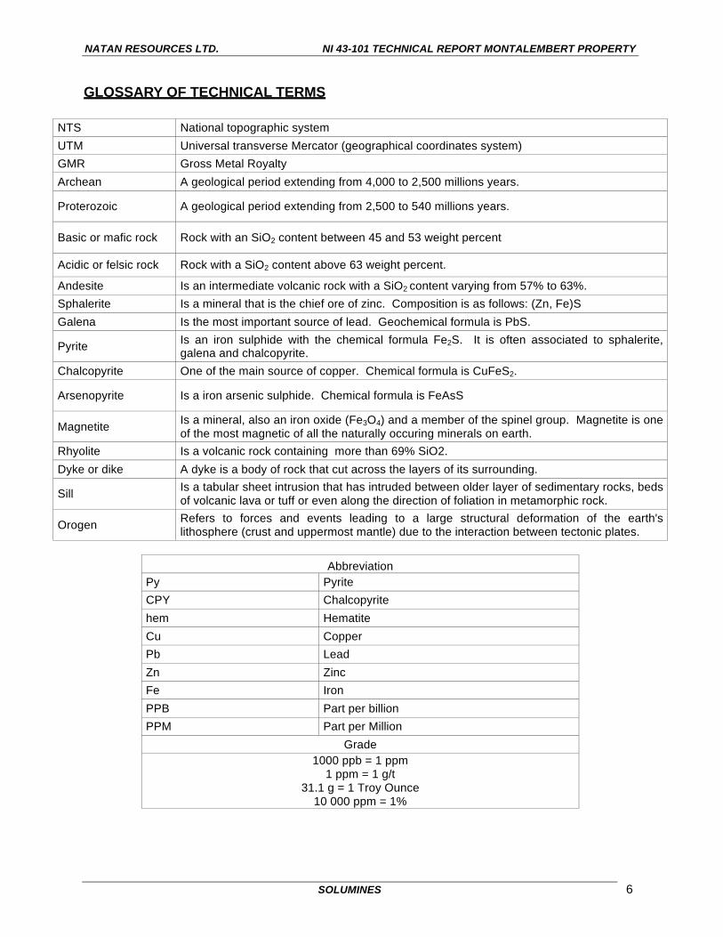
GLOSSARY OF TECHNICAL TERMS
NTS National topographic system UTM Universal transverse Mercator (geographical coordinates system) GMR Gross Metal Royalty Archean A geological period extending from 4,000 to 2,500 millions years.
Proterozoic A geological period extending from 2,500 to 540 millions years.
Basic or mafic rock Rock with an SiO2 content between 45 and 53 weight percent
Acidic or felsic rock Rock with a SiO2 content above 63 weight percent.
Andesite Is an intermediate volcanic rock with a SiO2 content varying from 57% to 63%.
Sphalerite Is a mineral that is the chief ore of zinc. Composition is as follows: (Zn, Fe)S Galena Is the most important source of lead. Geochemical formula is PbS.
Pyrite Is an iron sulphide with the chemical formula Fe2S. It is often associated to sphalerite, galena and chalcopyrite.
Chalcopyrite One of the main source of copper. Chemical formula is CuFeS2.
Arsenopyrite Is a iron arsenic sulphide. Chemical formula is FeAsS
Magnetite Is a mineral, also an iron oxide (Fe3O4) and a member of the spinel group. Magnetite is one of the most magnetic of all the naturally occuring minerals on earth.
Rhyolite Is a volcanic rock containing more than 69% SiO2. Dyke or dike A dyke is a body of rock that cut across the layers of its surrounding.
Sill Is a tabular sheet intrusion that has intruded between older layer of sedimentary rocks, beds of volcanic lava or tuff or even along the direction of foliation in metamorphic rock.
Orogen Refers to forces and events leading to a large structural deformation of the earth's lithosphere (crust and uppermost mantle) due to the interaction between tectonic plates.
Abbreviation
Py Pyrite CPY Chalcopyrite hem Hematite Cu Copper Pb Lead Zn Zinc Fe Iron PPB Part per billion PPM Part per Million
Grade 1000 ppb = 1 ppm
1 ppm = 1 g/t 31.1 g = 1 Troy Ounce
10 000 ppm = 1%

NATAN RESOURCES LTD. NI 43-101 TECHNICAL REPORT MONTALEMBERT PROPERTY
SOLUMINES 7
ILLUSTRATIONS
Fold in the enclosing rocks close to the shear zone
Stripped and washed vein

NATAN RESOURCES LTD. NI 43-101 TECHNICAL REPORT MONTALEMBERT PROPERTY
SOLUMINES 8
Sample with visible gold
Quartz vein and channel sample

NATAN RESOURCES LTD. NI 43-101 TECHNICAL REPORT MONTALEMBERT PROPERTY
SOLUMINES 9
Vein No 2, looking north

NATAN RESOURCES LTD. NI 43-101 TECHNICAL REPORT MONTALEMBERT PROPERTY
SOLUMINES 10
1.0) SUMMARY
The Montalembert property is made up of 132 map-designated cells totalling 7,293 ha that will expire
between May 13, 2017 and December 8, 2018. Exploration work in the amount of $102,960 will be
required upon renewal, along with mining duties of $7,876. Currently $153,175 in accrued work is
registered on the claims. One hundred (100) claims are listed under the name Globex Mining
Enterprises Inc., and 32 under the name of Raymond Bédard will be transferred to Globex. The
property is located in NTS 32F16 and 32G13 and covers part of Montalembert Township.
On November 16, 2016, Natan Resources signed an option agreement with Globex Mining
Enterprises to acquire a 100% interest in the Montalembert property. The main terms of the
agreement are as follows:
Cash Shares Work Requirement
On signing $300,000 1,500,000 $1,000,000 (within first 12-month period) First Anniversary $300,000 2,000,000 $1,000,000 (within second 12-month period) Second Anniversary $600,000 2,000,000 $4,000,000 (within third 12-month period) Third Anniversary $1,500,000 3,000,000 $4,000,000 (within fourth 12-month period) Fourth Anniversary $50,000 GMR2 n/a $5,000,000 (within fifth 12-month period)
Total $2,700,000 8,500,000 $15,000,000
The cash and share payments to be made by Natan prior to December 31, 2017, and the exploration
expenditure to be incurred prior to December 31, 2018, are firm commitments and must be made
even in the event that Natan terminates the option agreement and chooses not to exercise the
option.
Royalties of 6% are payable on the first 150,000 oz of gold recovered from the property and 3.5%
thereafter. An area of interest has been defined: if Natan acquires any ground within 3 km of the
boundaries of the present property, Natan will have to pay a 3% royalty on all the ore produced from
that property. Should Globex acquire any cells within 10 km of the boundaries of the present
property within the next three years, Globex shall offer the cells to Natan at cost, and the royalty to
Globex shall apply if production occurs.
To the knowledge of the author, there are no environmental liabilities pertaining to the Montalembert
property. All the claims are located on Category II Territory, where exploration is allowed under
specific conditions as follows: “A claim titleholder is invited to communicate with the Cree Nation
Government. Category II Lands are those where the Native people shall have exclusive hunting,
2 GMR royalty : Gross Metals Royalty

NATAN RESOURCES LTD. NI 43-101 TECHNICAL REPORT MONTALEMBERT PROPERTY
SOLUMINES 11
fishing and trapping rights. Mining exploration and geoscientific works shall be carried out in such a
manner as to avoid unreasonable conflict with the rights of the Native people under the Hunting,
Fishing and Trapping Regime”. South of the property, exploration is currently prohibited.3 Finally,
the usual forestry management permit is also required to perform field work involving bush clearing,
and other permits should be obtained for rock stripping and/or bulk sampling, etc.
The property shows an elevation ranging from 315 to 360 m above sea level. Part of the property
was logged years ago. The forest is made up of spruce, fir, birch alders and some swampy areas.
There are creeks and lakes on the property and in the neighbouring area that can be used as a
source of water for drilling or any future mining. At this latitude, there is no permafrost. Overburden
depth varies from 0 to 25 m.
The property can be easily accessed from the Cree village of Waswanipi using Route 113 and then
logging roads. Services not available at Waswanipi can be obtained from Chibougamau, 137 km to
the east by road. There is no mining infrastructure on the property, but there is a powerline along
Route 113 less than 10 km from the gold showings.
The first report produced by the Quebec Government was a preliminary report on the Capisisit Lake
area by J.E. Gilbert in 1947. In the same period, prospectors working for N.A. Timmins (1938) Ltd.
discovered the Galena, No. 2 and Rabbit veins. Spectacular results were obtained, with up to 5.03
oz of gold over 1.3 feet. In 1951, the same company drilled 31 holes, 30 of them over the gold
showings. Unfortunately, no assays were reported. In 1974, Rochelom Mines conducted
exploration work over the same area. A bulk sample made up of rock from many blasted trenches
along the Galena Vein was taken. The bulk sample was assayed by Quebec’s Department of
Natural Resources and returned 0.37 oz Au/T over a width of 2.12 feet and a length of 355 feet.
Since 1974, several other companies have held parts of the area now covered by the property, the
most important being Northgate Patino, Falconbridge Nickel, Orimex and Antoro. Falconbridge
discovered two other veins about 1.4 km north of the Galena and No. 2 veins, the Veine Neuve and
Veine du Lac. The latter returned a gold value of 51 g Au/T from a grab sample. In 1986, Orimex did
line cutting and geological, Mag, VLF and Induced Polarization surveys, followed by
lithogeochemistry and humus surveys. Many anomalies were discovered. Later, in 1996, Orimex
merged with Antoro Resources, which added claims to the property and carried out other
geophysical and geochemical surveys, followed by 1,816 m of drilling in 11 holes. Only weak
anomalous results were obtained. Almost all the Antoro holes were drilled outside the area of the
3 Restriction No. 41500, Category I Lands
NATAN RESOURCES LTD. NI 43-101 TECHNICAL REPORT MONTALEMBERT PROPERTY
SOLUMINES 12
gold-bearing veins in the Alutor Lake area and on the pending claims. However, one hole the 97-
LA1-08, located north of Alutor Lake, cut a hydrothermal breccia from 4 to 27.3 m, with 2 to 20%
sulphides (pyrite, pyrrhotite and chalcopyrite) and visible gold from 20.3 to 20.6 m. Assay over this
section revealed only 164 ppb Au, 1.7 gAg/T and 3054 ppm Cu over 0.3 m. No re-assay using
metallic-sieve has been done. No historical or recent resources have ever been calculated for the
Montalembert property. During the 1973 exploration program, Rochelom Mines report a
metallurgical test going on at the Quebec Department of Natural Resources with different grinding
and cyanidation time, however results were never reported.
From a geological point of view, the property is located in the Abitibi sub-province, close to the NE
boundary with the Opatica sub-province. The general metamorphism is at the greenschist facies
and can go up to the amphibolite facies close to the intrusives. The Kapunapotagen fault, a major
fault, is located close to the property, to the north and east. On the property, formations strike
almost north-south with a steep dip to the east. The main geological feature on the property is the
volcano-sedimentary pile enclosed between two plutons: the Capisisit and the Waswani. The
geology is cut by a network of faults oriented WNW, NNE, NE and ENE, that have the effect of
delimiting geological blocks. The type of orebody sought in this area is of the greenstone-hosted
quartz-carbonate vein-type, like those found in the Val-d’Or area, such as the Lamaque and Sigma
mine deposits. Given the geology, another type of orebody should be considered, namely
volcanogenic massive sulphide deposit of the Horne or Matagami Lake type, as there are
intermediate volcanics close to intrusive contacts, along with some Input anomalies4.
Stripping and sampling done by Globex in 2015 extended the Galena and No. 2 veins in a north-
south direction, confirmed the geology described by N.A. Timmins and Rochelom, and returned gold
assays of up to 4.66 g Au/T from the Galena Vein and 64.48 g Au/T from No. 2 Vein. During the site
visit, the author observed the favourable geology and saw specks of gold in many places on the
Galena Vein, confirming the property’s gold potential.
With the knowledge acquired over the years, it is clear that the potential of the property lies in gold-
bearing quartz veins. The geological features observed in the field, namely shear zones with quartz-
carbonate veins mineralized with some sulphides (pyrite, chalcopyrite, pyrrhotite, galena and
arsenopyrite) and gold, correspond to greenstone-hosted quartz-carbonate vein-type deposits.
4 Input anomalies : Airborne EM anomalies, EM system flown by Questor Surveys at the beginning of the 80’s. Was considered at this time as a deep penetrating EM system.

NATAN RESOURCES LTD. NI 43-101 TECHNICAL REPORT MONTALEMBERT PROPERTY
SOLUMINES 13
In conclusion, the property is strategically located between the Waswanipi and the Capisisit plutons,
where the deformation of the volcano-sedimentary pile is at its maximum. The plutons have induced
shear zones and reoriented the stratification, which is now parallel to their contacts, or almost north-
south, with a steep dip to the east. The Capisisit Pluton was probably the heat source for
remobilization of the quartz and gold in the shear zones where the Galena, No. 2 and Rabbit veins
are located, and probably others not yet discovered. The property and the pending claims cover the
main part of the volcano-sedimentary band, located between the Waswanipi and Capisisit plutons.
As the results obtained so far from historical work reported and more recently by Globex show the
excellent potential of the property for gold discovery, the following two-phase program is
recommended. In Phase I, it is suggested to:
• Purchase a high-definition satellite photo to help locate:
- The old drill roads;
- To locate old stripping and outcrops;
- And possibly, observe the main structural features, faults, folds, etc.
• Complete a helicopter-borne Mag and EM survey on flight lines 100 m apart to:
- Help with mapping of rock formations;
- Define the contacts between the volcanic and intrusive rocks;
- Help in locating possible shear zones.
• Compile the results of the historical geochemical and lithogeochemical and induced polarization
surveys obtained by both companies and the government, as long as they can be located with a
good level of accuracy;
• Strip and clean the extensions of the Galena and No. 2 veins, and if the Veine du Lac and Veine
Neuve are located, strip and sample those veins, and if possible, strip the area of hole 97-LA1-
08 where the hydrothermal breccia is located.
Diamond drilling is recommended for Phase II, mainly on the Galena and No. 2 veins, as well as on
Veine du Lac and Veine Neuve and any new targets discovered. A total of 7,000 m of drilling is
suggested.
The budget for Phases I and II is indicated on next page.

NATAN RESOURCES LTD. NI 43-101 TECHNICAL REPORT MONTALEMBERT PROPERTY
SOLUMINES 14
Budget
Phase I: Geophysical survey, geology, stripping and compilation Proposed work Quantity Unit Unit cost Total
Program preparation 3 days $650 $1 950 Purchase of a high definition satellite photo (50 cm) $4 000
Helicopter-borne Mag and EM surveys with 100 m spacing between flight lines, including report
1000 km $120 $120 000
Compilation of all the geochemical surveys and I.P surveys in a database.
$25 000
Stripping, geology and sampling over the extensions of Galena and No 2 veinsand Veine du Lac if we can locate it
$125 000
Assays 300 samples $50 $15 000
Geological verification of anomalies $25 000
NI 43-101 update and report for assement purposes $15 000
Contingency 12% $39 714
Total Phase I $370 664
Phase II: Drilling Proposed work Quantity Unit Unit cost Total
Program preparation 4 days $650 $2 600 Diamond drilling all inclusive, mob-demob, wood cutting, geologist, samples etc.
7000 m $140 $980 000
Insert data in a 3D model $40 000 NI 43-101 update and report for assessment purposes $20 000
Contingencies 12% $104 260
Total Phase II $1 146 860
Total Phases I et II $1 517 524

NATAN RESOURCES LTD. NI 43-101 TECHNICAL REPORT MONTALEMBERT PROPERTY
SOLUMINES 15
2.0) INTRODUCTION
2.1) RECIPIENT
This technical report on the Montalembert property has been prepared at the request of Natan
Resources Ltd. (“Natan”).
2.2) OBJECTIVES
This report describes the scientific and technical information concerning the exploration activities,
both historical and recent, carried out on the Montalembert property.
2.3) SOURCE OF DATA AND INFORMATION
This report is based on the documentation provided by Natan and Globex Mining Enterprises Inc.
(Globex) and statutory work filed with the Quebec Ministry of Energy and Natural Resources
(MERNQ). A complete, detailed list of the documentation used is given in Item 27, “References”.
2.4) SCOPE OF THE PERSONAL INSPECTION BY THE QUALIFIED PERSON
The author visited the property on November 16, 2016. During the visit the author was accompanied
by Denis Jolin, technician, working for Globex. Including the trip from and to Chibougamau, the visit
lasted one day. No samples were taken by the author, but free gold was observed in quartz veins at
several locations in the field.
2.5) UNITS USED IN THIS REPORT
Unless otherwise indicated, the units used in this report are in the metric system, amounts are in
Canadian dollars, and coordinates are in the UTM system. NAD83, Zone 18.
3.0) RELIANCE ON OTHER EXPERTS
Donald Théberge, P. Eng., M.B.A., is the author of this report and is responsible for the preparation
of all the sections of this report. No other experts were involved in the preparation of the report.

NATAN RESOURCES LTD. NI 43-101 TECHNICAL REPORT MONTALEMBERT PROPERTY
SOLUMINES 16
4.0) PROPERTY DESCRIPTION AND LOCATION
4.1) AREA
The property is made up of 132 map-designated cells, in one block, totalling 7,293.06 ha.
4.2) LOCATION
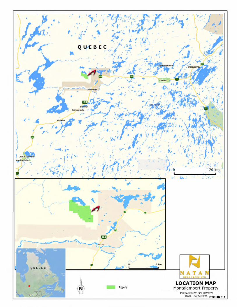
The property is located in NTS 32F16 and 32G13, in Montalembert Township. The claims block is
centred on UTM coordinates 423,860E/5,518,785N. The centre of the property is located
approximately 10 km NNW of the village of Waswanipi and 84 km W of the town of Chapais. The
boundaries have not been surveyed and do not need to be surveyed, as they are already defined by
the NTS coordinate system. The property location is shown in Figure 1, “Location Map”.
4.3) TYPE OF MINERAL TENURE
The Montalembert property is made up of 132 map-designated cells that will expire between May 13,
2017 and December 8, 2018. Exploration work in the amount of $102,960 will be required upon
renewal, along with mining duties in the amount of $7,876. Currently, $153,575 in accrued work is
registered on the claims. One hundred (100) claims are registered in the name of Globex Mining
Enterprises Inc., and 32 claims registered to the name of Raymond Bédard will be transferred to
Globex in the coming days.
The claims are described in Schedule1, “Claims Description”, and illustrated in Figure 2, “Claims
Map”. Please note that 72 cells have been accepted very recently by the MERNQ and the claim
number did not still appear on MERNQ 32F16 claim map. Also as Mr. Bédard designated the cells
for Globex, the author has represented the property as entirely owned by Globex on the claim map.


NATAN RESOURCES LTD. NI 43-101 TECHNICAL REPORT MONTALEMBERT PROPERTY
SOLUMINES 19
4.4) NATURE AND EXTENT OF THE ISSUER’S TITLES
The terms of the option agreement with Globex Mining Enterprises Inc., which are described in a
press release issued by Natan Resources dated November 17, 2016, are as follows:
“Pursuant to the Agreement, Natan shall have the option to earn an undivided 100% right, title, and
interest in the Property (the “Option”), subject to the Gross Metal Royalty, by making aggregate cash
payments to Globex of $2,700,000, issuing an aggregate of 8,500,000 common shares and incurring
aggregate exploration expenditures of $15,000,000 on the property as described in Table 1:
TABLE 1: SUMMARY OF OPTION AGREEMENT Cash Shares Work Requirement
On signing $300,000 1,500,000 $1,000,000 (within first 12 month period)
First Anniversary $300,000 2,000,000 $1,000,000 (within second 12 month period)
Second Anniversary $600,000 2,000,000 $4,000,000 (within third 12 month period)
Third Anniversary $1,500,000 3,000,000 $4,000,000 (within fourth12 month period)
Fourth Anniversary $50,000 GMR n/a $5,000,000 (within fifth12 month period)
Total $2,700,000 8,500,000 $15,000,000
The cash and share payments to be made by Natan prior to December 31, 2017, and the exploration
expenditure to be incurred prior to December 31, 2018, are firm commitments and must be made
even in the event that Natan terminates this Option Agreement and chooses not to exercise the
Option.
Notwithstanding the foregoing, at any time following the 2nd anniversary of the Effective Date of this
Option Agreement, the exploration expenditures may be deferred for up to 12 months (resulting in all
subsequent exploration expenditure requirements to be deferred 12 months) in the event that both:
(i) the London spot price for Au is less than $1,200 US per troy ounce for 30 consecutive days, and
(ii) Natan has less than $1 million CDN funds in its treasury. In the event that exploration
expenditures are deferred as contemplated hereby, Natan shall be obligated to pay Globex a penalty
of $150,000 in cash and issue to Globex 1,000,000 common shares of Natan within 10 business
days of providing notice to Globex of such deferral of exploration expenditures.”

NATAN RESOURCES LTD. NI 43-101 TECHNICAL REPORT MONTALEMBERT PROPERTY
SOLUMINES 20
4.5) ROYALTIES AND AREA OF INTEREST
4.5.1) ROYALTIES
Concerning royalties and area of interest, a press release issued by Globex on November 17, 2016,
states that:
“Commencing at the 4th anniversary, Natan shall pay Globex an annual $50,000 advance GMR
Royalty payment, recoupable from first production from the property. Globex shall receive a 6%
GMR (9,000 ounces) of the first 150,000 ounces of precious metals (Au, Ag) recovered from the
property and a 3.5% GMR from all production beyond the initial 150,000 ounces of recovered
precious metals.
Due to the high-grade nature of the observed gold on the property, high-grade mineralization will be
collected during the Natan earn-in period and shall remain the property of Globex, with Globex
retaining the option of selling or requesting delivery of 50% of the high-grade samples and retaining
the income therefrom. Should Natan not earn its 100% interest in the property, all high-grade gold
samples shall be delivered to Globex. Once Natan has earned a 100% interest in the property, 25%
of high-grade gold samples collected thereafter shall be deliverable to Globex in addition to Globex’s
retained 3.5% GMR.
4.5.2) AREA OF INTEREST
The same press release by Globex also states that:
“Any properties acquired by Natan within 3 km of the current outside boundary of the property shall
have a royalty payable to Globex of 3% GMR, with Globex retaining 20% of any high-grade gold
samples recovered therefrom.
Should Globex acquire any cells within 10 km of the current external boundary of the property within
the next 3 years, Globex must offer the cells at cost to Natan, with Globex retaining a 3% GMR on
production from said cells and 20% of high-grade gold samples therefrom. Seventy-two cells
currently staked by Globex adjoining the property lie within 10 km of the current external boundary of
the Montalembert property and will fall under the terms of this agreement.
NATAN RESOURCES LTD. NI 43-101 TECHNICAL REPORT MONTALEMBERT PROPERTY
SOLUMINES 21
4.6) ENVIRONMENTAL LIABILITIES
To the knowledge of the author, there are no environmental liabilities pertaining to the Montalembert
property.
4.7) REQUIRED PERMITS
All the claims are located on Category II Territory, where exploration is allowed under specific
conditions as follows: “A claim titleholder is invited to communicate with the Cree Nation
Government. Category II Lands are those where the Native peoples shall have exclusive hunting,
fishing and trapping rights. Mining exploration and geoscientific works shall be carried out in such a
manner as to avoid unreasonable conflict with the rights of the Native people under the Hunting,
Fishing and Trapping Regime”. South of the property, exploration is currently prohibited.5
Finally, the usual forestry management permit is also required to perform field work involving bush
clearing, and other permits should be obtained for rock stripping and/or bulk sampling, etc.
5 Restriction No. 41500, Category I Lands

NATAN RESOURCES LTD. NI 43-101 TECHNICAL REPORT MONTALEMBERT PROPERTY
SOLUMINES 22
5.0) PHYSIOGRAPHY, ACCESSIBILITY, INFRASTRUCTURE AND CLIMATE
5.1) TOPOGRAPHY, ELEVATION, VEGETATION AND DRAINAGE
The topography of the property is relatively hilly, with an elevation ranging from 315 to 360 m above
sea level. Part of the property logged years ago shows small tree growing, while unlogged parts
show spruce, fir, birch, alder and some swampy areas. The area is a preferred habitat of big game
like moose and bear and small game like fox, partridge, jackrabbit and beaver. There are several
creeks and lakes on the property and in the neighbouring area that can be used as a source of water
for any future drilling or mining. Historical drilling in the surrounding area reveals an overburden
depth varying from 0 to 25 m. Outcrops are relatively scarce, with about only 2 to 3% outcropping
areas. At this latitude, there is no permafrost.
5.2) ACCESSIBILITY
The property can easily be accessed from the village of Waswanipi, using Route 113 for about 3 km
to the NE,6 after which a network of logging roads provides access to many part of the property,
including areas recent stripped by Globex. The Cree village of Waswanipi is located about 137 km
west of the town of Chibougamau via Route 113 from Chibougamau to Chapais and then to
Waswanipi, a drive of approximately 1.5 hours. Figure 3 on the next page shows the access roads
to the property.
5.3) INFRASTRUCTURE
There is no mining infrastructure on the property. However, there is a powerline along Route 113
that can be used if electricity is needed on the property. Room and board can be obtained in
Waswanipi, along with exploration services from Cree contractors. Services not available in
Waswanipi can be obtained in Chibougamau, 137 km east by the road.
5.4) CLIMATE
The property is located at the limit between the subarctic and humid continental climates. This area
is characterized by long, cold winters and short, cool summers. Daily average temperature ranges
from -19 °C in January to +17 °C in July. Annual precipitations average 700 mm of rain and 300 cm
of snow. Break-up usually occurs at the end of April and freeze-up in late November.7
6 The entrance to the logging road network is located at UTM coordinates 431,648E/5,507,736N 7 Quebec climate normals 1981-2010, Chapais-2 weather station.


NATAN RESOURCES LTD. NI 43-101 TECHNICAL REPORT MONTALEMBERT PROPERTY
SOLUMINES 24
6.0) HISTORY
6.1) GEOLOGICAL WORK BY THE QUEBEC GOVERNMENT
The first geological reports covering the property area were by J.E. Gilbert, and were released under
report numbers RP 210 and RG 048 respectively in 1947 and 1951, the first one being a preliminary
report and the second the final report. Gilbert mapped the Capisisit Lake area, which covers almost
all of the current Montalembert property, including the pending claims. Gilbert established the main
geological units, the granite and volcanic rocks, as well as several fault zones, and established a
preliminary stratigraphy of the area. It is interesting to note that in recommendations at the end of
his report, Gilbert mention the SE part of the map area (the N.A. Timmins showing) as the most
promising area for gold discoveries. He also gave a good description of the N.A. Timmins showing,
cited below:
“ As mentioned previously, a gold-bearing quartz vein was discovered in the fall of 1947, just south
of the present area. Following the discovery, an intensive programme of staking and prospecting
was carried on by a number of companies, syndicates, and individuals throughout the field season of
1948. Toward the end of the summer, gold was discovered by prospectors for N.A. Timmins (1938)
Ltd., at a locality about half a mile north of the southern boundary, and one mile west of the eastern
limit, of the present area.
Careful prospecting northward along the projected strike of the last-named find led to the discovery
by the same company, in 1949, of coarse, visible gold in a number of quartz veins, most of them in
shear zones in volcanic or gabbroic rocks. The gold is reported to occur in cross-fractures in the
quartz veins, some of which are quite large, and in silicified, schistose greenstone adjacent to the
veins. The mineralized structures apparently trend close to north-south.”
In 1970, G. Duquette published a report entitled Archean Stratigraphy and Ore Relationships in the
Chibougamau District, or ES-008. The map included with this report shows that relative to the
Chibougamau stratigraphy, the Montalembert property is underlain by mafic intrusives (gabbro, etc.),
undetermined felsic intrusives and the volcanic and sedimentary rocks of the Gilman Formation,
which are part of the Roy Group.
Later on, in 1982 and 1984, Y. Hébert re-mapped the Capisisit Lake area, with results reported in
DP 82-07 and ET 84-07. Hébert refined the geology mapped by Gilbert in the 1940s. On his map,
the gold showings (N.A. Timmins) are located in a felsic pyroclastic unit located between the

NATAN RESOURCES LTD. NI 43-101 TECHNICAL REPORT MONTALEMBERT PROPERTY
SOLUMINES 25
Capisisit Lake granite to the east and basaltic volcanics to the west. The felsic pyroclastites end at a
NE-SW trending fault to the north.
In parallel with the geological mapping of 1982, Hébert took 15 soil samples, or 1 sample/50 km2,
over the Capisisit Lake area. Later on, in 1986, M.B. Otis reported the results in MB 86-12.
Samples were analyzed for Cu, Zn, Pb, Ni, Co, Mn, Ag and LOI. Unfortunately, no assays were
done for Au, Ag, As or Hg. Very weak anomalous results were obtained for Co, Cu, Pb and Zn.
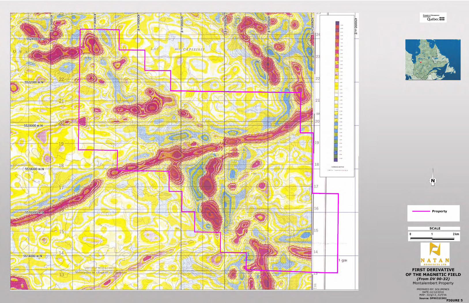
Only the Mn assays revealed a truly anomalous result, with 472 ppm. In 1984 an EM Input survey
was released. Several isolated anomalies were located on the property. They are shown on figure
4 at the end of this section.
In 1990, the Ministry of Energy and Natural Resources released aeromagnetic maps (total field and
gradient) for NTS 32F16. These maps show the main features of the property, including an ENE-
trending diabase dyke and the main intrusives, results for the property area are illustrated on figure 5
at the end of this section. Other large-scale and/or academic studies seeking to establish the
stratigraphy or correlate the contact between the Opatica and Abitibi sub-provinces have been
conducted since 1996 by various authors and are cited in the bibliography. A description of those
studies is beyond the scope of this report.
TABLE 2: REGIONAL AND THEMATIC STUDIES AND SURVEYS BY THE MERNQ8 Geological Reports
Year Report # Description Results 1947 RP 210 (A) Geological mapping of the Capisisit
Lake area (preliminary report) First stratigraphy established. Recommendation to explore the N.A. Timmins showings area.
1951 RG 048 (A) Final report geological mapping of the Capisisit Lake area.
First stratigraphy established. Recommendation to explore the N.A. Timmins showings area.
1970 ES 008 Archean stratigraphy and ore relationship in the Chibougamau area.
Extends the geological formations found in the Chibougamau area up to the Montalembert Twp. to the west.
1982 DP 82-07 Geological survey of the Capisisit Lake area (preliminary report)
Refines the geology mapped by Gilbert and locates the N.A. Timmins showings in pyroclastics rocks.
1984 ET 84-07 Geological survey of the Capisisit Lake area (final report report)
Refines the geology mapped by Gilbert and locates the N.A Timmins showings in pyroclastics rocks.
1984 DP 84-25 Airborne EM Input survey over the lake Waswanipi area, and covering the Montalembert property.
Several Input anomalies discovered on the property.
1984 DP 84-41 Compilation of the airborne EM Input anomalies for the Abitibi.
Several Input anomalies located on the property.
1986 MB 86-12 Soil geochemistry in the Capisisit Lake area. Only 15 samples taken.
Only Mn assays were truly anomalous, with 472 ppm.
8 MERNQ: Ministère de l’Énergie et des Ressources Naturelles du Québec (Quebec Ministry of Energy and Natural Resources)

NATAN RESOURCES LTD. NI 43-101 TECHNICAL REPORT MONTALEMBERT PROPERTY
SOLUMINES 26
1990 DV 90-32 Processing of aeromagnetic data 32F16.
Maps show the main intrusives and an ENE-trending diabase dyke.
Large-scale, thematic and/or academic studies
1996 MB 96-33 Structural study of the Abitibi sub-province
Map of the deformation zones in the Abitibi region and their correlation with ore deposits.
2001 MB 2011-14 Analysis of geophysical lineaments in the Abitibi sub-province.
Seeks to establish a correlation between gold deposit and geophysical lineaments.
2006 EP 2006-02 Study concerning the potential for orogenic gold deposits in the Abitibi sub-province.
Potential mainly established on known showings and orebodies and their correlation with structural deformation.
2010 MB 2014-08 Regional compression vs high gold potential. 2014 MB 2014-04 Structural and metamorphic study of the NE boundary of the Abitibi Greenstone Belt. 2014 MB 2014-26 Intrusions associated with deformation corridors and their correlation with gold
mineralization. 2016 MB 2016-01 Long-term tectonometamorphic history of the Opatica and Abitibi sub-provinces.


NATAN RESOURCES LTD. NI 43-101 TECHNICAL REPORT MONTALEMBERT PROPERTY
SOLUMINES 29
6.2) GEOLOGICAL WORK BY MINING AND/OR EXPLORATION COMPANIES
The area containing the gold showings on the current Montalembert property was staked for the first
time by N.A. Timmins (1938) Ltd. following the discovery of gold by Joe Armstrong of O’Brien Gold
Mines Ltd. L.G. Smith summarized the exploration done by N.A. Timmins during the 1949 season in
a letter to the Deputy Minister dated November 29, 1949. Smith described the mineralized zones as
follows:
“Early in June coarse free gold was found while trenching on a quartz vein two and a half feet wide,
occupying a strong N-S shear zone about 2,000 feet north of our original discovery. Further work on
the new find has traced the vein for 1,100 feet and we have found gold, some of it spectacular, at
irregular intervals for 525 feet. The gold occurs in cross-fractures in the quartz and in the silicified
schist alongside.
A parallel vein system, named the Galena Vein, has been uncovered 300 feet west. It consists of a
strong shear zone 20 feet wide with several quartz veins and stringers. The most continuous quartz
vein is on the east side of the shear. It averages fourteen inches in width and fine gold has been
found over a length of 150 feet.
All the quartz veins in which free gold has been found are mineralized with fine galena, and are
paralleled or cut transversally by narrow bands of feldspar porphyry. The porphyries are sheared
and gold is found on the shear planes.”
Based on those results, Smith recommended 5,000 feet of drilling.
In 1950 and 1951, the same company drilled one hole on the Inspiration Option north of the gold
showings discovered in 1948-49, and 30 holes on the gold showings area, for a total of 8,677 feet, or
2,645.4 m. Holes were drilled close to each other and revealed roughly the same geology: andesitic
tuffs and agglomerates, with quartz veins and quartz feldspar porphyries. Gabbro and quartz diorite
were intersected locally. Rocks were often altered and sheared. It is not indicated whether samples
were taken in any of the holes, and no assays were reported. A report produced in 1974 by Veilleux
for Rochelom Mines indicates that one of the hole drilled by N.A. Timmins on Vein No. 1 (located on
Native land outside the property) returned 1.97 oz Au/ton over a true width of 4 ft. Another hole
drilled 340 ft to the SW returned 0.61 oz Au/ton over a core length of 1.9 ft. All other holes (drilled
on the property) returned only low gold values. During the same period, in 1951, N.A. Timmins
carried out a magnetic survey on the SE part of the current Montalembert property.
In a letter dated September 12, 1951, W. Weber reported the following assay results for the Galena
Vein:

NATAN RESOURCES LTD. NI 43-101 TECHNICAL REPORT MONTALEMBERT PROPERTY
SOLUMINES 30
- 5.03 oz Au/ton over 1.3 ft;
- 3.69 oz Au/ton over 1 ft;
- 2.4 oz Au/ton over 2.6 ft;
- 1.28 oz Au/ton over 2.6 ft.
It is not specified if they were channel or chip samples: while the letter does not really indicated this,
it later says: “The drilling has indicated the continuation of the structure conditions, but did not
intersect commercial indications.”
The next work was reported in 1966, with a sketch of surface work in the form of trenching and shaft
sinking on the south part of the Montalembert property. The sketch is very general and no results or
reports were submitted. A geological and geochemical survey was also done in 1966 on the
Surprenant Prospect by Rosario Exploration, on the SW part of the property. At first, Rosario was
looking for gold, but the geological survey returned only low gold values; however, chalcopyrite and
molybdenum were observed in the quartz veins, and exploration was reoriented towards
molybdenum.
In 1972, Soquem had a property in the Capisisit Lake area. Five small grids of lines were cut and
surveyed with Mag and EM. Two of the grids were located on the pending claims, one close to
Alutor Lake and the other just south of Capisisit Lake. Drilling was recommended, but no results
were ever reported.
In 1973, Rochelom Mines made a thorough evaluation of the No. 2 and Galena veins. Each vein
was previously stripped and cleaned by the vendors of the claims. Veilleux summarizes the bulk
sampling method as follows:
“ Under Rochelom and on recommendations of Georges E. Moody, Eng., bulk sampling of the
Galena Vein was undertaken; it consisted of drilling and blasting a trench some two feet wide, in 5-
foot lengths along the vein and its branches for a total length of 405 feet; small grab samples were
taken before part of the muck was discarded. The remaining muck was resplit so as to form a bulk
sample of approximately 125 pounds for each 5-foot length; 80 such samples representing 5 tons of
muck were taken out by muskeg and sent to the pilot mill of the Quebec Department of Natural
Resources.
Assays results for the grab samples gave 0.67 oz. of gold per ton over a width of 2.06 feet and a
total length of 405 feet. When values over 1 ounce gold per ton are included in the calculations, the
value rises to 0.93 oz gold per ton; rejects of these samples sent to the Quebec Department of
Natural Resources gave 0.59 oz. of gold per ton. Results of assaying of the bulk samples by the

NATAN RESOURCES LTD. NI 43-101 TECHNICAL REPORT MONTALEMBERT PROPERTY
SOLUMINES 31
Quebec Department of Natural Resources returned 0.37 oz. gold per ton over a width of 2.12 feet
and a length of 355 feet. Figure 6, on next page, summarize the sampling done by Rochelom.
In 1976, a quartz vein on the Surprenant claims, located immediately SW of Alutor Lake, was
sampled. Thirteen chip samples were assayed for Au, Ag, and Cu. No anomalous results were
obtained. In 1980, Falconbridge Nickel held the Rochelom property, which covered the south part of
the current property. VLF and Mag were completed. Several anomalies were discovered, but at that
stage no drilling was recommended.
In 1984, Northgate Patino Mines held the SW part of the current property. Northgate completed line
cutting followed by Mag and EM (MaxMin) surveys. Several EM anomalies were found. Later, in
November and December, Explorations Nord-Ouest drilled five of the EM anomalies for a total of
3,147 feet or 959.5 m of drilling. The holes mainly intersected intrusives units with thin sections of
dacite and andesite. No anomalous results were obtained.
In 1985, Falconbridge Nickel Ltd. held the claims covering the south central part of the current
Montalembert property. Falconbridge completed an induced polarization and geochemical survey.
Many IP anomalies coincident with previous Mag and VLF axes were located. The geochemical
survey discovered slightly anomalous sectors, including one comprising the main quartz veins zone
and another to the south. A humus survey indicated a gold anomaly over the Galena Vein but failed
to indicate any new anomolies elsewhere. In his report, Bérubé quotes a comment from another
report written by Cloutier concerning the Veine du Lac, located 1.4 km north of the Rochelom
showing: “The vein is 1.8 to 4.2 m wide, traced southerly for more than 5 m. Heavy assay sample
bags yielded impressive gold values: 51.0, 16.3, 9.8, 6.5, and 0.5 grams Au/T.”
Follow-up work on the Falconbridge property was reported in 1985 in the form of eight drill holes
totalling 3,533 feet, or 1,077.1 m. Holes cut a succession of granite, gabbro and intermediate to
mafic lavas. The most interesting hole, Hole 021-03, cut many pyritized quartz veins over 60.5 ft
(18.44 m) from 334 ft (101.8) to 394.5 ft (120.24 m) at the contact between volcanic rocks and
gabbro. No anomalous gold values were obtained, with the exception of 405 ppb Au/5.5 ft (1.67 m).
In 1986, Explorations Nord-Ouest drilled three holes for a total of 2,117 feet, or 645.3 m. Mainly
basalt and gabbro units were intersected. Anomalous gold values were obtained, usually associated
with some sulphide mineralization in quartz-carbonates veins. Gold values are usually in the range
of 0.02 to 0.03 oz Au/ton over lengths of 0.8 to 3.4 ft, with a peak of 0.09 oz Au/ton over 0.8 ft from
Hole MT-85-1.


NATAN RESOURCES LTD. NI 43-101 TECHNICAL REPORT MONTALEMBERT PROPERTY
SOLUMINES 33
From 1986 to 1990, Orimex Resources Inc. carried out line cutting, geology and Mag, VLF and IP
surveys, followed by lithogeochemistry and humus geochemical surveys. Many anomalies were
discovered, both geophysical and geochemical. Four thousand metres of drilling was
recommended, but was never executed.
In May 1996, Antoro Resources and Orimex Resources merged, and Antoro became the owner of
the 102 claims located in Montalembert Township. More claims were added soon after, and in 1997,
the project was made up of 202 claims totalling 3,236 ha. The Antoro property covered the west part
of the current property and almost all of the pending claims. In GM 54493, Leduc gave a good
summary of the exploration work performed by Antoro prior to diamond drilling.
“The exploration campaign completed during last October (1996) totalled 180 km of cut lines on five
different grids of this 30 km2 property. All the new lines and part of the lines cut in 1987 were
surveyed with a geochemical survey made up of 2,653 samples of horizon A, prospecting and
geological surveying, Beep-Mat prospecting and lithogeochemical sampling.
Magnetic, electromagnetic and induced polarization surveys were done over more than 155 km of
cut lines. These surveys confirmed at depth the 13 anomalies detected during the reconnaissance
work of 1988 and provided more precision on their configuration.
In the Alutor Lake area, a major anomaly in the shape of an S with a total length of 3 km and a width
of 100 m was confirmed, along with two other deeper anomalies, each 700 m long and 150 m wide.
On the LA-3 grid, a new anomaly over 200 m wide was traced over more than 2 km.
In the Alutor Lake area, soil and rock sampling has confirmed the presence of gold. The best
samples returned a grade of 534 ppb (LA-3 grid) and 963 ppb (LA-1 grid); the same sample returned
a silver value of 41.3 ppm. At Himalaya Lake, a large circular anomaly 1 km in diameter was
interpreted in the MW part of the LH-2 grid; the chargeability zone is more than 200 m wide and
corresponds to the flanks of a steep hill. Soil sampling returned a gold value of 2.7 g/t from a
sample taken over a circular chargeability anomaly with a 400 m diameter.”9
Following the exploration work of 1996, Antoro completed a drilling program of 11 holes totalling
1,816.15 m in the winter of 1997. The holes cut a majority of mafic intrusives and intermediate to
mafic volcanics cut by QFP and felsic dykes. The rock is locally sheared and altered with
disseminated sulphides. Very weakly anomalous Au, Cu, Ni, Cr, Pt , Pd and Zn values were
obtained. However, one hole the 97-LA1-08, located north of Alutor Lake, cut a hydrothermal
9 Translated from Leduc, M., 1997: Sommaire des travaux d’exploration effectués sur la propriété Montalembert de Ressources Antoro inc., GM 54493.

NATAN RESOURCES LTD. NI 43-101 TECHNICAL REPORT MONTALEMBERT PROPERTY
SOLUMINES 34
breccia from 4 to 27.3 m, with 2 to 20% sulphides (pyrite, pyrrhotite and chalcopyrite) and visible
gold from 20.3 to 20.6 m. Assay over this section revealed only 164 ppb Au, 1.7 gAg/T and 3054
ppm Cu over 0.3 m. No re-assay using metallic-sieve has been done.
The next work by Antoro was reported in 2002, by which time the original 202-claim property was
reduced to 69 claims, covered 80% of the current property and the pending claims. Work performed
in 2002 consisted of a till sampling program over the circular magnetic anomalies to evaluate their
diamond potential. The results of the search for kimberlites were negative.
Nothing more happened until 2015, when Globex staked 58 cells forming the current Montalembert
property. Seventy-two cells were added later but their acceptance by the Quebec Ministry of Natural
Resources is still pending. Exploration work by Globex is described in Item 9.0, “Exploration”.
Table 3 summarize historical exploration on the property and in its immediate vicinity.
TABLE 3: SUMMARY OF HISTORICAL WORK Year GM # Company Exploration Results
1949 00911 N.A. Timmins (1938) Ltd.
Letter to the Deputy Minister
Report on the exploration work of 1948 and 1949.
1950 00951(A) N.A. Timmins (1938) Ltd.
One hole drilled on the Inspiration Option
No analytical results indicated.
1951 00951(B) N.A. Timmins (1938) Ltd
31 holes drilled for a total of 2,645.4 m, including the one on the Inspiration Option.
No assays indicated on the logs.
1951 01899 N.A. Timmins (1938) Ltd.
Report on a magnetometer survey.
Magnetic anomalies located immediately south of the current property.
1951 01351 N.A. Timmins (1938) Ltd.
Letter summarizing the exploration program
1966 17876 Blais claims Location sketch of surface work
Very difficult to locate. Not really pertinent.
1966 18121 Rosario Exploration Geological survey on the Surprenant prospect
1966 18122 Rosario Exploration Geochemical survey Discovery of a molybdenum anomaly. 1972 28862 Soquem Geophysical survey Drilling was recommended but never
carried out. 1974 30084 Rochelom Mines Sampling program Bulk sample over the Galena Vein
returned 0.37 oz Au/ton over a width of 2.12 ft and a length of 355 ft.
1976 33894 Surprenant claims Sampling program No anomalous results. 1980 36741 Falconbridge Nickel Geophysical surveys Anomalies discovered but no holes
recommended. 1984 41994 Northgate Patino
Mines EM and Mag surveys. Several EM anomalies found.
1985 41993 Les Explorations Nord-Ouest Ltée
Geophysical surveys and 5 DDH for a total of 959.5 m
No anomalous gold values obtained.

NATAN RESOURCES LTD. NI 43-101 TECHNICAL REPORT MONTALEMBERT PROPERTY
SOLUMINES 35
Year GM # Company Exploration Results 1985 42317 Falconbridge Nickel Geophysical, geochemical
surveys. Anomalies discovered and drilling recommended. Mentions Veine du Lac, which returned up to 51 g Au/T in a grab sample.
1985 42739 Falconbridge Ltd. 8 holes drilled for a total of 1,077.1 m
No anomalous gold values obtained, with the exception of 405 ppb Au/5.5 ft (1.67 m).
1985 43087 Northgate Patino Mines
Induced polarization survey (I.P)
Several IP axes located.
1986 43577 Les Explorations Nord-Ouest Ltée
3 holes drilled totalling 645.3 m.
Gold values are usually in the range of 0.02 to 0.03 oz Au/ton over lengths of 0.8 to 3.4 ft, with a peak of 0.09 oz Au/ton over 0.8 ft from Hole MT-85-1
1988 46482 Orimex Resources Geological and geophysical report.
Detailed geophysical surveys recommended.
1990 50330 Orimex Resources Induced polarization and geochemical surveys.
4,000 m of drilling recommended, but not executed.
1997 54491 Antoro Resources IP, Mag, VLF Alutor Lake area
Anomalies discovered in 1987 were confirmed along with new ones. 3,000 m of drilling recommended.
1997 54493 Antoro Resources Summary of exploration work
Provides a summary of exploration work done in 1996.
1997 54494 Antoro Resources Reconnaissance geological mapping.
More detailed geological survey recommended
1997 54497 Antoro Resources Geochemical sampling Several anomalous results obtained. 1997 54499 Antoro Resources Beep-Mat survey Many samples taken, assays results
not indicated in the report. 1997 56097 Antoro Resources 11 drill holes totalling
1,816.15 m. Many very weak anomalies obtained for Au, Cu, Ni, Cr, Pt, Pd and Zn.
2002 60695 Antoro Resources Till sampling, search for kimberlites.
Results were negative
2002 60696 Antoro Resources Report on the potential of the property.
Drilling of 4 holes on IP anomalies recommended
2015 69300 Globex Mining Enterprises
Geophysical survey Described in Item 9 of this report
2016 Not reported
Globex Mining Enterprises
Stripping and sampling Described in Item 9 of this report
6.3) HISTORICAL RESOURCES
Historical resources have never been calculated or reported for the Montalembert property.
6.4) HISTORICAL MINERAL PROCESSING AND METALLURGICAL TESTING
In GM 30084, Veilleux initiated a metallurgical test concerning the gold mineralization from the
Galena Vein. The test is described as follows:
“At the same time, metallurgical tests were done so as to find the best possible recovery: different
tests consisted grinding to 200 mesh then to 325 mesh with different time of cyanidation, either 24,

NATAN RESOURCES LTD. NI 43-101 TECHNICAL REPORT MONTALEMBERT PROPERTY
SOLUMINES 36
48 or 72 hours; tailings were analyzed in each case so as to find the most economical way of
treating this kind of gold ore with the best recovery. Details of these tests shall be available in a
report produced by the scientific center of the Quebec Department of Natural Resources at the end
of January 1974.
This report was never reported and is now impossible to find.
6.5) PRODUCTION
There has never been any production from the Montalembert property.
6.6) HISTORICAL DRILLING
From 1950 to 1997, 58 holes were drilled for a total of 7,143.5 m on, and in the immediate vicinity of
the property. Table 4 on the next page gives the technical description of each hole when available,
and a very short summary of the results obtained. Please note that the UTM coordinates were
obtained from the MERNQ Sigeom website, and their accuracy is questionable, particularly for older
holes. Figure 7 shows the position of the holes relative to the property.

NATAN RESOURCES LTD. NI 43-101 TECHNICAL REPORT MONTALEMBERT PROPERTY
SOLUMINES 37
TABLE 4: HISTORICAL DRILLING
Year GM # Company Hole UTME UTMN Az Dip Length (m)
Core size
O/B (m)
Remarks
1950 00951A N.A. Timmins Inspiration Option
1 425875 5514884 318 45 114.3 ? 1.5 Hole cut gabbro, granite and andesite. No assays.
1950 00951B N.A. Timmins 1 426721 5513673 270 47 160 ? 2.7 Andesitic tuff and agglomerate, QFP, lamprophyre dyke, quartz diorite dykes. No assays indicated.
1950 00951B N.A. Timmins 2 426766 5513670 270 58 139.6 ? 1. Andesitic tuff and agglomerate, QFP, QV, dacitic tuff and agglomerate, granitic dyke. No assays indicated.
1950 00951B N.A. Timmins 3 426718 5513699 270 44 52.1 ? 1.5 Andesitic tuff and agglomerate, QV, stringers. No assays reported.
1950 00951B N.A. Timmins 4 426714 5513646 270 45 53.3 ? 1.8 Andesitic tuff and agglomerate, locally talcose, lamprophyre dyke, porphyry dyke, QV. No assays reported.
1950 00951B N.A. Timmins 5 426735 5513589 262 45 266.7 ? 4.3 Andesitic tuff and agglomerate, QFP, QV, quartz diorite, tuff and agglomerate locally chloritized, some gabbro. No assays reported.
1950 00951B N.A. Timmins 6 426725 5513758 270 42 53.6 ? 3 Andesitic tuff and agglomerate locally altered, aplitic dykes, granitic dykes, QV. No assays reported.
1950 00951B N.A. Timmins 7 426695 5513874 270 45 68.3 ? 1.5 Andesitic tuff and agglomerate, aplitic dykes, QV, felsic dykes, granitic dykes. No assays reported.
1950 00951B N.A. Timmins 8 426720 5513621 262 44.5 56.1 ? 1.8 Andesitic tuff and agglomerate, QP, QV, lamprophyre dyke, altered tuff, etc. No assays reported.
1950 00951B N.A. Timmins 9 426656 5513576 262 44 67 ? 2.4 Andesitic tuff and agglomerate, quartz-‐carbonates stringers, QP, felsic dykes, altered tuff, etc. No assays reported.
1950 00951B N.A. Timmins 10 426654 5513601 262 44 152.4 ? 1.2 Andesitic tuff and agglomerate locally chloritized, QFP, QV, gabbro. No assays reported.
1950 00951B N.A. Timmins 11 426655 5513560 262 38.5 61.9 ? 1.8 Quartz diorite, QV, andesitic tuff and agglomerate, QFP. No assays reported.
1950 00951B N.A. Timmins 12 426627 5513608 262 43 67 ? 3 Andesitic tuff and agglomerate, quartz diorite, tuff, altered zone, quartz stringers, QP, QV, altered tuff. No assays reported.

NATAN RESOURCES LTD. NI 43-101 TECHNICAL REPORT MONTALEMBERT PROPERTY
SOLUMINES 38
Year GM # Company Hole UTME UTMN Az Dip Length (m)
Core size
O/B (m) Remarks
1950 00951B N.A. Timmins 13 426650 5513631 262 42 69.5 ? 1.2 Andesitic to dacitic tuff and agglomerate, FP, QV, quartz diorite, tuff and agglomerate altered. No assays reported.
1950 00951B N.A. Timmins 14 426669 5513504 262 45 62.5 ? 2.4 Andesitic to dacitic tuff and agglomerate, fairly well fractured, some sections with small garnets, QV. No assays reported.
1950 00951B N.A. Timmins 15 426743 5513383 262 45 61 ? 4.3 Andesitic to dacitic tuff and agglomerate, QV, tuff, altered rock. No assays reported.
1950 00951B N.A. Timmins 16 426886 5513146 238 54.5 62.8 ? 5.2 Locally altered andesitic tuff and agglomerate, QFP, QV, rock sheared, quartz stringers, FP. No assays reported.
1950 00951B N.A. Timmins 17C 426857 5513026 238 45 61 ? 2.4 Andesitic to dacitic tuff and agglomerate, gabbro, shear, FP. No assays reported.
1950 00951B N.A. Timmins 18 426872 5513048 328 45 61 ? 2.4 Andesitic to dacitic tuff and agglomerate, shear zone, QV, augite porphyry, FP, diorite. No assays reported.
1950 00951B N.A. Timmins 19 426884 5512829 270 70 124 ? 2.1 Gabbro, QV, tuff, granite, granite dyke, andesite. No asays reported.
1950 00951B N.A. Timmins 20 426845 5512828 270 70 60 ? 2.4 Gabbro, tuff, diorite. No assays reported.
1950 00951B N.A. Timmins 21 426930 5513086 238 43 89.9 ? 13.1 Granite, gabbro, aplite, FP, tuff, syenite. No assays reported.
1950 00951B N.A. Timmins 22 426844 5513008 327 45 61 ? 2.7 Andesite, gabbro, QP, andesitic tuff. No assays reported.
1950 00951B N.A. Timmins 23 426807 5513013 336.5 44 67.7 ? 2.4 Gabbro, FP or pegmatite, andesitic tuff, andesite. No assays reported.
1950 00951B N.A. Timmins 24 426771 5513011 349 44.5 61.3 ? 2.4 Gabbro, andesite, andesitic tuff, FP. No assays reported.
1951 00951B N.A. Timmins 25 ? ? 261 57 79.2 ? 1.4 Andesitic to dacitic agglomerate and tuff, QV, rx locally chloritized. No assays reported.
1951 00951B N.A. Timmins 26 ? ? 246 45 121.6 ? 4.9 Andesitic tuff and agglomerate locally chloritized, QV, sheared in places. No assays reported.
1951 00951B N.A. Timmins 27 ? ? 240 46.5 77.1 ? 3.4 Andesitic tuff locally sheared and chloritized, QV, andesitic agglomerate. No assays reported.
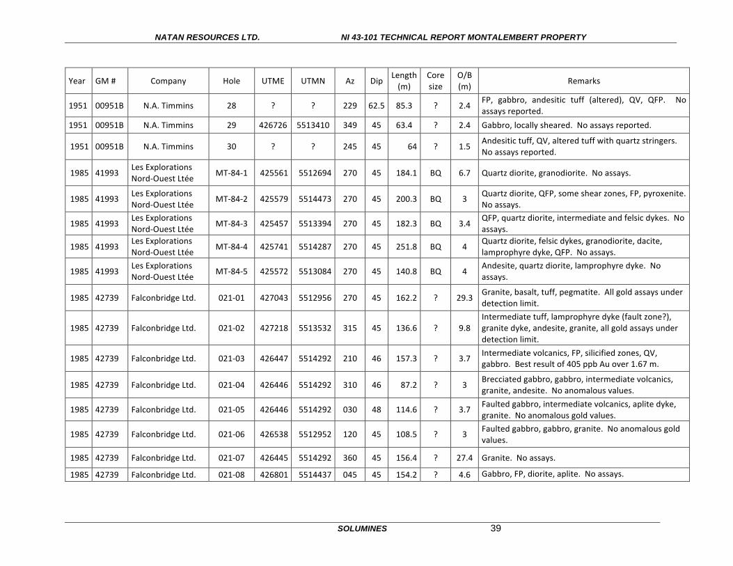
NATAN RESOURCES LTD. NI 43-101 TECHNICAL REPORT MONTALEMBERT PROPERTY
SOLUMINES 39
Year GM # Company Hole UTME UTMN Az Dip Length (m)
Core size
O/B (m) Remarks
1951 00951B N.A. Timmins 28 ? ? 229 62.5 85.3 ? 2.4 FP, gabbro, andesitic tuff (altered), QV, QFP. No assays reported.
1951 00951B N.A. Timmins 29 426726 5513410 349 45 63.4 ? 2.4 Gabbro, locally sheared. No assays reported.
1951 00951B N.A. Timmins 30 ? ? 245 45 64 ? 1.5 Andesitic tuff, QV, altered tuff with quartz stringers. No assays reported.
1985 41993 Les Explorations Nord-‐Ouest Ltée MT-‐84-‐1 425561 5512694 270 45 184.1 BQ 6.7 Quartz diorite, granodiorite. No assays.
1985 41993 Les Explorations Nord-‐Ouest Ltée
MT-‐84-‐2 425579 5514473 270 45 200.3 BQ 3 Quartz diorite, QFP, some shear zones, FP, pyroxenite. No assays.
1985 41993 Les Explorations Nord-‐Ouest Ltée MT-‐84-‐3 425457 5513394 270 45 182.3 BQ 3.4
QFP, quartz diorite, intermediate and felsic dykes. No assays.
1985 41993 Les Explorations Nord-‐Ouest Ltée MT-‐84-‐4 425741 5514287 270 45 251.8 BQ 4
Quartz diorite, felsic dykes, granodiorite, dacite, lamprophyre dyke, QFP. No assays.
1985 41993 Les Explorations Nord-‐Ouest Ltée MT-‐84-‐5 425572 5513084 270 45 140.8 BQ 4
Andesite, quartz diorite, lamprophyre dyke. No assays.
1985 42739 Falconbridge Ltd. 021-‐01 427043 5512956 270 45 162.2 ? 29.3 Granite, basalt, tuff, pegmatite. All gold assays under detection limit.
1985 42739 Falconbridge Ltd. 021-‐02 427218 5513532 315 45 136.6 ? 9.8 Intermediate tuff, lamprophyre dyke (fault zone?), granite dyke, andesite, granite, all gold assays under detection limit.
1985 42739 Falconbridge Ltd. 021-‐03 426447 5514292 210 46 157.3 ? 3.7 Intermediate volcanics, FP, silicified zones, QV, gabbro. Best result of 405 ppb Au over 1.67 m.
1985 42739 Falconbridge Ltd. 021-‐04 426446 5514292 310 46 87.2 ? 3 Brecciated gabbro, gabbro, intermediate volcanics, granite, andesite. No anomalous values.
1985 42739 Falconbridge Ltd. 021-‐05 426446 5514292 030 48 114.6 ? 3.7 Faulted gabbro, intermediate volcanics, aplite dyke, granite. No anomalous gold values.
1985 42739 Falconbridge Ltd. 021-‐06 426538 5512952 120 45 108.5 ? 3 Faulted gabbro, gabbro, granite. No anomalous gold values.
1985 42739 Falconbridge Ltd. 021-‐07 426445 5514292 360 45 156.4 ? 27.4 Granite. No assays.
1985 42739 Falconbridge Ltd. 021-‐08 426801 5514437 045 45 154.2 ? 4.6 Gabbro, FP, diorite, aplite. No assays.

NATAN RESOURCES LTD. NI 43-101 TECHNICAL REPORT MONTALEMBERT PROPERTY
SOLUMINES 40
Year GM # Company Hole UTME UTMN Az Dip Length (m)
Core size
O/B (m) Remarks
1985 43577 Les Explorations Nord-‐Ouest Ltée MT-‐85-‐1 425653 5512295 270 45 183.8 BQ 4.3
Andesite, pyroxenite dyke, quartz gabbro, quartz diorite, QFP (altered and sheared), basalt. Anomalous gold values of up to 0.09 oz Au/ton over 0.8 ft were obtained.
1985 43577 Les Explorations Nord-‐Ouest Ltée MT-‐85-‐2 425655 5512502 270 45 185 BQ 3.35
Basalt, granodiorite dyke, quartz gabbro, pyroxenite dyke, QFP, several anomalous gold values obtained, peaking at 0.04 oz Au/ton over 1.2 ft.
1985 43577 Les Explorations Nord-‐Ouest Ltée MT-‐85-‐3 425492 5513295 270 45 276.45 BQ 3.7
Basalt, lamprophyre dyke, quartz gabbro, gabbro. Several anomalous gold value of up to 0.07 oz Au/ton over 0.8 ft.
1997 56097 Antoro Resources 97-‐LA2-‐01 423252 5516460 225 50 166 ? 4 Basalt, hornblendite, serpentine, rock often altered and sheared.
1997 56097 Antoro Resources 97-‐LA2-‐02 423612 5516029 225 50 132.5 ? 7 Andesitic tuff, hornblendite, QFP, pyroxenite, rhyolite, basalt, norite, gabbro.
1997 56097 Antoro Resources 97-‐LA2-‐05 423273 5517663 225 50 152.3 ? 3 Pyroxenite, basalt, andesite, hornblendite, shear zones, serpentine. Casing left in hole.
1997 56097 Antoro Resources 97-‐LA2-‐06 423418 5517240 225 50 154.1 ? 3 Pyroxenite, hornblendite, shear zones, altered zones, andesite, breccia, norite.
1997 56097 Antoro Resources 97-‐LA2-‐07 424804 5517689 135 50 184.1 ? 3.6 Basalt, mylonitized zone. Casing left in hole.
1997 56097 Antoro Resources 97-‐LA1-‐08 425017 5518100 135 50 175.5 ? 4
Hole begins in a hydrothermal breccia from 4 to 27.3 m with visible gold from 20.3 to 20.6 m, assay on this section returned 164 ppb Au, 1.7 gAg/T and 3054 ppm Cu. No re-‐assay with metallic sieve. This interval also contains between 2 to 20% sulphides. Remaining part of the hole cut gabbro, basalt, QV, disseminated sulphides. Casing left in hole.
1997 56097 Antoro Resources 97-‐LA1-‐09 425482 5518506 135 50 179.95 ? 3 Gabbro, breccia, basalt, disseminated sulphides, granitic dyke, granite. Casing left in hole.

NATAN RESOURCES LTD. NI 43-101 TECHNICAL REPORT MONTALEMBERT PROPERTY
SOLUMINES 41
Year GM # Company Hole UTME UTMN Az Dip Length (m)
Core size
O/B (m) Remarks
1997 56097 Antoro Resources 97-‐LA1-‐10 425605 5517489 135 50 196.7 ? 3 Gabbro, andesite, breccia, disseminated sulphides, granite, granitoïd. Casing left in hole.
1997 56097 Antoro Resources 97-‐LA3-‐11 424768 5515869 225 50 205.85 ? 3.5 Basalt, gabbro, breccia, disseminated sulphides. Casing left in hole.
1997 56097 Antoro Resources 97-‐LA3-‐12 425190 5515220 225 50 176.65 ? 3 Basalt, gabbro, breccia, disseminated sulphides. Casing left in hole.
1997 56097 Antoro Resources 97-‐LA3-‐14 425684 5514526 225 50 175.5 ? 2 Breccia, pyroxenite.
For holes location, please refer to figure 7 entitled Historical Drilling on next page. When the MERNQ was not able to locate a drill hole its UTM coordinates are not indicated in the table.


NATAN RESOURCES LTD. NI 43-101 TECHNICAL REPORT MONTALEMBERT PROPERTY
SOLUMINES 43
7.0) GEOLOGICAL SETTING AND MINERALIZATION
7.1) GENERAL GEOLOGICAL SETTING
The Montalembert property is located in the northeast part of the Superior Province, which itself lies
in the heart of the Canadian Shield. The Superior Province extends from Manitoba to Quebec, and
is mainly made up of Archean rocks. The general metamorphism is at the greenschist facies, except
in the vicinity of intrusive bodies, where it can go to the amphibolite-to-granulite facies. In Quebec,
the eastern extremity of the Superior Province has been classified into the following sub-provinces,
from south to north: Pontiac, Abitibi, Opatica, Nemiscau, Opinaca, La Grande, Ashuanipi, Bienville
and Minto.10 According to Card and Ciesielski (1986), the property is located in the Abitibi sub-
province, close to the boundary with the Opatica sub-province. Figure 8, “General Geological
Setting”, shows the position of the property within the Superior Province.
FIGURE 8: GENERAL GEOLOGICAL SETTING
10 Classification by Hocq, M., in Géologie du Québec, MM 94-01

NATAN RESOURCES LTD. NI 43-101 TECHNICAL REPORT MONTALEMBERT PROPERTY
SOLUMINES 44
7.2) REGIONAL AND PROPERTY GEOLOGY
On a more regional scale, the property is located at the NE end of the Abitibi sub-province, close to
the boundary with the Opatica sub-province. In ES-008, Duquette (1970) links the regional geology
of the property with the geological formations observed in the Chibougamau area. If this is the case,
the volcanics rocks on and in the vicinity of the property are the western extension of Cycle 2 of the
volcanic and sedimentary rocks of the Roy Formation.
Structurally, the region containing the Montalembert property is located between two major features:
an anticline to the south and a syncline to the north. In a study targeting the NE part of the Abitibi
sub-province (MB 2014-04), Daoudene et al show a major shear, the Kapunapotagen fault, situated
north and east of the property. North of the property, formations strike ENE with a dip to the NNW,
becoming almost N-S with a steep dip to the east in the south part of the property. Metamorphism
varies from greenschist to amphibolite.
At the property scale, the volcanic rocks and their comagmatic equivalents (gabbros) are located
between two intrusives, the Waswanipi Pluton and the Capisisit Pluton. “Both of these plutons have
strongly deformed and metamorphosed the encasing rocks. Many injections of granitic dykes,
syenite and aplites are observed in the encasing rocks. Feldspar porphyry dykes, with or without
quartz, are seen everywhere in the volcanic rocks; it seems that they were put in place before the
granitic intrusives as they show the same deformation as the volcanites, close to the contacts with
the plutons.11 Table 5 give an outline of the stratigraphy, and Figure 9 shows the regional geology.
The property is cut by a network of faults with orientations varying from WNW, NNE, NE and ENE.
These faults divide the property into geological blocks, with the Sturgeon Lake gabbro complex and
the Bell River basalt formation. In conclusion, the property is strategically located between the
Waswanipi and Capisisit plutons, where the deformation of the volcano-sedimentary pile is at its
maximum. The plutons have induced shear zones and reoriented the stratification, which is now
parallel to their contacts, or almost north-south, with a steep dip to the east. The Capisisit Pluton
was probably the heat source for remobilization of the quartz and gold in the shear zones where the
Galena, No. 2 and Rabbit veins are located.
Historical documents consulted refer to gold bearing quartz veins, but in July 2015 during the first
visit on the project, geologist working for Globex took 37 samples. One of them taken in the Galena
Vein sector, returned 33.5 gAu/T from an intermediate to mafic lava, dark grey, strongly sheared,
hematized and with ankerite, and 3 to 4% fine disseminated pyrite. This sample proves the gold
11 From Hébert, Y., 1986 : Géologie de la région du Lac Capisisit. ET 84-07.

NATAN RESOURCES LTD. NI 43-101 TECHNICAL REPORT MONTALEMBERT PROPERTY
SOLUMINES 45
mineralization is not limited to quartz veins but may exists in the shear zones even if quartz veins are
absent. Finally as the quartz feldspar porphyries show the same level of deformation as the
volcanites, they may also contain gold mineralization.
The property geology is shown in Figure 10.
TABLE 5: TABLE OF FORMATIONS12 Protorezoic Unaltered mafic intrusives Olivine diabase
Archean
Granitoids
Capisisit Lake granite Syenite and diorite Waswanipi Lake granite Feldspar porphyry
Sedimentary rocks Siltstone and arkose Gneiss and biotite schist Sills of magnetite-bearing gabbro
Sills of differentiated gabbros
Peridotite and pyroxenite Melanocratic gabbro Mesocratic gabbro Leucocratic gabbro
Andesitic volcanics
Andesite with phenocrist of pyroxene/hornblende and plagioclase Sills of comagmatic gabbros Andesitic tuff
Mafic volcanics
Massive or pillowed basaltic lava Sills of comagmatic gabbros Intermediate to mafic tuff Felsic pyroclastites
Porphyritic basalts Basaltic lavas with plagioclase phenocrist Sills of comagmatic gabbros
12 From Hébert, Y., 1984 : Géologie de la région du Lac Capisisit, ET 84-07


NATAN RESOURCES LTD. NI 43-101 TECHNICAL REPORT MONTALEMBERT PROPERTY
SOLUMINES 48
7.3) MINERALIZATION
The most important mineralized zone on the property, and the reason the property was acquired, is
the N.A Timmins/Rochelom showings area, located on the south part of the property. This area
contains the Galena, No. 2 and Rabbit veins. These veins show gold mineralization associated with
silicified shear zones containing quartz veins with 1 to 5% pyrite and/or pyrrhotite, with traces of
chalcopyrite and galena.
Following exploration by Globex, the Galena vein has now been stripped over a length of 183 m and
an average width of 3 m, and the No. 2 vein has been stripped over a length of 89 m and a width of
6 m. In 2015, two new trenches oriented E-W, or perpendicular to the structure, were also stripped
and reach the Galena and No. 2 Veins.; they are 111 and 127 m long, respective, with an average
width of 3 m. Work by N.A Timmins at the end of the 1940s on the Galena vein returned values of:
- 172.43 g Au/T (5.03 oz Au/t) over 0.4 m;
- 12.49 g Au/T (3.69 oz Au/t) over 0.3 m;
- 82.27 g Au/T (2.4 oz Au/t) over 0.79 m;
- 43.88 g Au/T (1.28 oz Au/t) over 0.79 m;
Bulk sampling by Rochelom (1974) returned an average of 11.51 g Au/T (0.37 oz Au/t) over a length
of 108.2 m and a width of 0.65 m. Gold assaying by the Bourlamaque assay laboratory over 80
samples returned an average of 20.84 g/T (0.67 oz/t) with high assays cut to 31.1 g/T; uncut, the
result rises to 28.93 g/T (0.93 oz/t).
In July 2015, during the first visit on site by Globex, 37 samples were taken and assayed for gold.
One sample numbered D063671 taken in the Galena Vein sector, returned 33.5 gAu/T from an
intermediate to mafic lava, dark grey, strongly sheared, hematized and with ankerite, with 3 to 4%
fine disseminated pyrite. Systematic sampling also in 2015, by Globex revealed values up to 4.66 g
Au/T in a grab sample from the Galena vein, and up to 64.48 g Au/T in the No. 2 Vein. During the
site visit, the author observed specks of free gold in the Galena vein.
Other mineralized zones also exist but have been less worked. About 1.4 km north of the Galena,
No. 2 and Rabbit veins, Falconbridge found the Veine Neuve and Veine du Lac. The latter returned
values of up to 51 g Au/T in grab samples (Bérubé 1985). One hole, the 97-LA1-08 drilled by Antoro
and located north of Alutor Lake, cut a hydrothermal breccia from 4 to 27.3 m, with 2 to 20%
sulphides (pyrite, pyrrhotite and chalcopyrite) and visible gold from 20.3 to 20.6 m. Assay over this
section revealed only 164 ppb Au, 1.7 gAg/T and 3054 ppm Cu over 0.3 m. No re-assay using
metallic-sieve has been done.

NATAN RESOURCES LTD. NI 43-101 TECHNICAL REPORT MONTALEMBERT PROPERTY
SOLUMINES 49
Geological mapping also revealed several other showings with sub-economic values for Au, Cu, Zn,
Cr and Mo. No more work has been done on those showings.
8.0) DEPOSIT TYPES
8.1) GREENSTONE HOSTED QUARTZ-CARBONATE VEIN DEPOSITS
The mineralization observed on the Montalembert property, mainly the N.A Timmins/Rochelom
showings, belongs to the family of greenstone-hosted quartz-carbonates vein deposits, as described
by Dubé and Gosselin (2007).13 This type of deposit contains all the quartz-carbonate vein deposits
enclosed in volcanic or intrusive rocks. Dubé and Gosselin provide a good description of this type of
deposit:
“Greenstone-hosted quartz-carbonate vein deposits typically occur in deformed greenstone belts of
all ages, especially those with variolitic tholeiitic basalts and ultramafic komatiitic flows intruded by
intermediate to felsic porphyry intrusions, and sometimes with swarms of albitite or lamprophyre
dykes. They are distributed along major compressional to transtensional crustal-scale fault zones in
deformed greenstone terranes commonly marking the convergent margins between major
lithological boundaries such as volcano-plutonic and sedimentary domains. The large greenstone-
hosted quartz-carbonates vein deposits are commonly spatially associated with fluvio-alluvial
conglomerate distributed along major crustal fault zones. This association suggests an empirical
time and space relationship between large-scale deposits and regional unconformities.
These types of deposits are most abundant and significant, in terms of total gold content, in Archean
terranes. However, a significant number of world class deposits are also found in Proterozoic and
Paleozoic terranes. In Canada they represent the main source of gold and are mainly located in the
Archean greenstone belts of the Superior and Slave provinces. They also occur in Paleozoic
greenstone terranes of the Appalachian orogeny and in the oceanic terranes of the Cordillera.
The greenstone-hosted quartz-carbonate vein deposit corresponds to structurally controlled complex
epigenetic deposits characterized by simple to complex networks of gold-bearing, laminated quartz-
carbonates fault-fill veins. These veins are hosted by moderately to steeply dipping, compressional,
brittle-ductile shear zones and faults with locally associated shallow-dipping extensional veins and
13 Dubé, B., and Gosselin, P., 2007: Greenstone-hosted quartz-carbonates vein deposits, in Goodfellow, W.D., ed., Mineral deposits of Canada: A synthesis of major deposit types, district metallogeny, the evolution of geological provinces and exploration methods: Geological Association of Canada, Mineral Deposits Division, Special publication No 5, p 49-73.

NATAN RESOURCES LTD. NI 43-101 TECHNICAL REPORT MONTALEMBERT PROPERTY
SOLUMINES 50
hydrothermal breccias. The deposits are hosted by greenschist to locally amphibolite-facies
metamorphic rocks of dominantly mafic composition and formed at intermediate depth (5-10 km).
The mineralization is syn- to late-deformation and typically post peak greenschist facies or syn-peak
amphibolite facies metamorphism. They are typically associated with iron carbonate alteration.
Gold is largely confined to the quartz-carbonate vein network but may also be present in significant
amount within iron-rich sulphidized wall-rock selvages or within silicified and arsenopyrite-rich
replacement zones.
There is general consensus that the greenstone-hosted quartz-carbonate vein deposits are related
to metamorphic fluids from accretionary processes and generated by prograde metamorphism and
thermal re-equilibration of subducted volcano-sedimentary terranes. The deep seated, Au-
transporting metamorphic fluid has been channelled to higher crustal levels through major crustal
faults or deformation zones. Along its pathway, the fluid has dissolved various components–notably
gold–from the volcano-sedimentary packages, including a potential gold-rich precursor. The fluid is
then precipitated as vein material or wall-rock replacement in second and third order structures at
higher crustal levels through fluid pressure cycling processes and temperature, pH and other physic-
chemical variations.
The Sigma-Lamaque mines in the Val-d’Or area are good examples of this type of orebody. Figure
11 shows the depth of formation of this type of deposit.
FIGURE 11: GREENSTONE-HOSTED QUARTZ-CARBONATE VEIN DEPOSITS: DEPTH OF FORMATION

NATAN RESOURCES LTD. NI 43-101 TECHNICAL REPORT MONTALEMBERT PROPERTY
SOLUMINES 51
8.2) VOLCANOGENIC MASSIVE SULPHIDE (VMS) DEPOSITS
While less probable than the greenstone-hosted quartz-carbonate vein deposits on the property, the
possibility of VMS deposits remains. Chalcopyrite and/or zinc mineralization has been observed at
many places on the property and there are several Input anomalies on the property, which could
indicate the presence of a massive sulphide deposit. The geology is also favourable, with volcanic
rocks in contact with a felsic intrusive.
Known examples of this type of deposit, albeit in less metamorphosed formations, are the Horne
mine in Rouyn-Noranda and the Matagami Lake mine in Matagami. Figure 12 shows a cross
section through a typical undeformed VMS-type deposit.
FIGURE 12: CROSS-SECTION THROUGH AN IDEALIZED UNDEFORMED VMS DEPOSIT
9.0) EXPLORATION
Natan has not undertaken any exploration work since acquiring the property. The exploration work
done by Globex, the property vendor, which designated the cells in 2015-16 and explored the area
of the N.A Timmins/Rochelom showings, is summarized below.
The work was carried out from July to November 2015, and consisted of geological reconnaissance,
line cutting, a Mag survey, systematic mapping and sampling, and trench stripping and sampling. All
the work was done on the area south of the Vieux Lacs; the location of this area is shown in Figure
13, entitled “Location of line cutting and trenches”.

NATAN RESOURCES LTD. NI 43-101 TECHNICAL REPORT MONTALEMBERT PROPERTY
SOLUMINES 52
During the reconnaissance survey, a total of 37 samples were taken on the Galena and No. 2 veins
and in the Veine Neuve area (south of the Vieux Lacs). Eighteen samples from the Galena vein
returned a peak value of 33.5 g Au/T (grab), with other samples returning gold values of between
0.006 and 0.916 g/T. In the No. 2 vein area, 10 samples returned values of from 0.012 to 0.51 g
Au/T. Seven samples from the Veine Neuve area gave values of from 0.037 to 1.85 g Au/T.
A total of 46.1 km of line were cut, and the correspondent magnetic survey was conducted. The Mag
survey defined a strong magnetic band striking N-S, probably resulting from a pyroxenite. The
borders of this anomaly suggest a possible fold or fault. Systematic geological surveying was
carried out on the cut lines, and 412 samples were taken and assayed for gold. Three main units
were mapped: a gabbro, an andesite and a pyroxenite. Samples taken from these units revealed a
few anomalous gold results, all under 0.2 g Au/T. Two types of quartz veins were observed in all the
rocks units: tension veins and shear-zone-related veins. The best gold result was 1.23 g Au/T.
During the fall of 2015, trenches on the Galena and No. 2 veins were cleaned and extended, along
with new perpendicular stripping. The Galena vein was stripped over a length of 183 m and a width
of 3 m. The No. 2 vein was stripped over a length of 89 m and a width of 5 m. The new
perpendicular trenches are 111 and 127 m long with an average width of 3 m. Part of the access
road was stripped over 15 m to check for the possible extension of the mineralized corridor. The
trenches were then sampled. One hundred and seventy nine samples were taken from the Galena
vein, 90 from the No. 2 trench and 11 from transversal trenches. The samples were assayed for
gold. Mineralized zones are usually under the form of NNW to N-S shears with white and smoky
quartz veins with 1 to 5% sulphides (pyrite, pyrrhotite, locally arsenopyrite and galena). Sampling
was difficult, as the stripped area was not washed. The best value obtained from the Galena vein
was 4.66 g Au/T. In the No. 2 vein, four high-grade gold values were obtained, ranging from 17.26
g/T to 64.48 g/T. Transverse trenches returned a best value of 0.109 g Au/T.
During the summer and fall of 2016, the remaining overburden in the trenches was washed out and
channel sampling was done on the Galena, No. 2 and transverse veins. Two hundred and eight
channel samples were taken in October and November. Assays and a report are still pending.
10.0) DRILLING
Natan and Globex have not done any drilling since acquiring the property. Historical drilling is
described in Item 6.5 of this report.
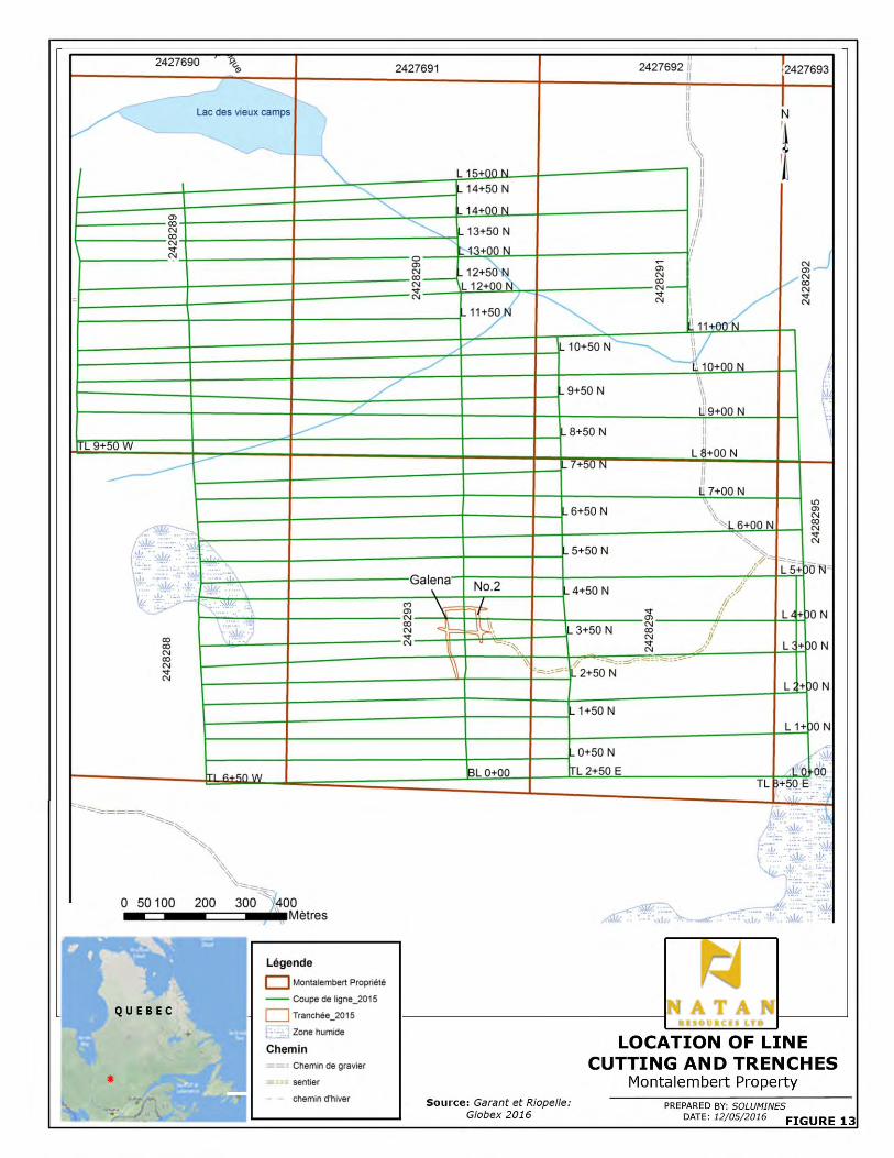

NATAN RESOURCES LTD. NI 43-101 TECHNICAL REPORT MONTALEMBERT PROPERTY
SOLUMINES 54
11.0) SAMPLE PREPARATION. ANALYSIS AND SECURITY
Natan has not done any sampling or assaying since acquiring the property. But as the acquisition of
the property by Natan is based for the most part on the results obtained by Globex, sample
preparation and analysis done by Globex is described. A report by Garant and Riopelle for Globex
released in February 2016 describes these items in detail, as translated and cited below:
“All the samples were sent to Laboratoire Expert of Rouyn-Noranda by the Globex employees. At
the laboratory, samples are crushed to 90% passing 10 mesh. The sample is then put through a
Jones riffle splitter and a 300-gram sub-sample is obtained and pulverized to 90% passing 200
mesh, then another 29.166-gram sub-sample is taken for treatment by fire assay. An atomic
absorption analysis is then completed to determine the gold concentration contained in the sample.
Samples with more than 1,000 ppb Au are analyzed using the gravity method, and if visible gold or a
nugget effect is observed, the metallic sieve analytical method is used. Globex quality control
includes the introduction of a blank or standard for each lot of 20 samples. Blanks, standards and
duplicates are also inserted and verified by the laboratory. When samples are re-analyzed by
gravity, this result is retained. If more than one gravity analysis is required, an average of these
results is calculated.”
A total of 728 samples, including 20 standards and 16 blanks, were assayed for gold by Laboratoire
Expert. Assay results for blanks and standards sent for QA/QC were satisfactory. In general, the
blanks (concrete blocks) were all under the detection limit. Five different standards were used.
Standard deviations of the result varied from 0 to 2 from the standard average. Only one showed an
anomalous result, and it was accepted as in fact the error was only 8%.
Sample security is not described by Globex, but as no security breaches were reported by Globex or
Laboratoire Expert, the author considers that no breach of security was detected from the time the
samples were taken in the field until their delivery to the laboratory.
12.0) DATA VERIFICATION
Exploration work done before the acquisition of the property by Globex is impossible to verify.
During the site visit, the author observed a drill site with a casing that likely witnessed a hole drilled
by Antoro. With respect to the work done by Globex, the author saw the stripping, washing and
channel sampling done and confirms the authenticity of the Globex work. This work was done
according to industry standards, both in terms of the geology and the environment.
NATAN RESOURCES LTD. NI 43-101 TECHNICAL REPORT MONTALEMBERT PROPERTY
SOLUMINES 55
13.0) MINERAL PROCESSING AND METALLURGICAL TESTING Metallurgical testing by Rochelom has been described at item 6.4. However as the result was not
reported and remain unknown, the author consider that no historical metallurgical testing occurred.
Natna nor Globex have not completed any metallurgical testing since acquiring the property.
14.0) MINERAL RESOURCE ESTIMATES Mineral resource estimates have never been calculated for the property, nor have historical
resources ever been reported on the property.
ITEMS 15 TO 22
Items 15 to 22 are as follows:
15.0) Mineral Reserve Estimates;
16.0) Mining Methods;
17.0) Recovery Methods;
18.0) Project Infrastructure;
19.0) Market Studies and Contracts;
20.0) Environmental Studies, Permitting and Social or Community Impact;
21.0) Capital and Operating Costs;
22.0) Economic Analysis.
These items refer to properties at the development stage and do not apply to the Montalembert
property.
23.0) ADJACENT PROPERTIES
Geomega Resources Inc., held the cells adjacent to the north and east of the Montalembert
property. Geomega did a reconnaissance geological survey in 2012, best result obtained was
6.1gAu/T and 31.2 gAg/T, at 5 km from the boundary of the property in sedimentary rock. Later in
2012 a high definition helicopter-borne Mag survey was completed along with limited geological and
till sampling survey. Best results obtained was 270 ppb Au in a grab sample and 539 ppb Au from
the heavy mineral concentrate from a till sample. No more work has been reported since that time.

NATAN RESOURCES LTD. NI 43-101 TECHNICAL REPORT MONTALEMBERT PROPERTY
SOLUMINES 56
Currently, there are no adjacent properties that might have an impact on the Montalembert property.
The Bachelor Mine owned by Metanor Resources Inc., is the closest mining operation and is located
approximately 31 km to SSW of the property. Riopelle and Garant summarizes the mineralization as
follows: The gold mineralization is associated to fragile deformation zones and dilatation zones in
ductile-fragile context. This deposit can be classified within the orogenic vein mineralization, but
also within the gold deposit associated to intrusives (Darling and Lafontaine 2011). In 2011, the
proven and probable reserves were of 645,494 tonnes at a grade of 7,54 gAu/T, with measured and
indicated resources of 643,826 tonnes at a grade of 7.96 gAu/T ( Darling and Lafontaine 2011).
Please note that the results obtained on Bachelor Mine are not an indication of the mineralization
present on the Montalembert property.
24.0) OTHER RELEVANT DATA AND INFORMATION All the relevant technical data and information available has been provided in the preceding items.
With regard to the project’s social acceptability, no particular problems are anticipated. Globex has
maintained good relations with the Native peoples of Waswanipi, and Natan will continue to work
with them.
25.0) INTERPRETATION AND CONCLUSIONS
The property has been explored for its gold content since 1948. The first vein discovered was the
No. 1 vein, located outside the property on Native land, leading to the discovery of the Galena, No. 2
and Rabbit veins, all located on the property. Gold assays reported by N.A. Timmins (1938) Inc.
returned spectacular values, with up to 172.43 g Au/T (5.03 oz) over 4 m from the Galena vein. In
1974, Rochelom Mines also reported spectacular gold values, mainly with a bulk sample that
returned an average of 11.51 g Au/T over a length of 108.2 m and a width of 0.65 m, with high
assays cut to 31.1 g Au/T; uncut, the result rises to 28.93 g Au/T. Thirty drill holes were reported by
N.A. Timmins on these veins; unfortunately, no samples are indicated on the logs and no assay
results are reported. Rochelom did not report any drill holes during the time it held the property.
Work by major and junior companies Northgate Patino, Falconbridge Nickel, Orimex and Antoro was
mainly concentrated on other parts of the property, and little work was done on the Galena and No. 2
veins. During this period, the Veine Neuve and Veine du Lac were discovered by Falconbridge.
Veine du Lac returned 51 g Au/T from a grab sample. One hole drilled by Antoro the 97-LA1-08,

NATAN RESOURCES LTD. NI 43-101 TECHNICAL REPORT MONTALEMBERT PROPERTY
SOLUMINES 57
located north of Alutor Lake, cut a hydrothermal breccia from 4 to 27.3 m, with 2 to 20% sulphides
(pyrite, pyrrhotite and chalcopyrite) and visible gold from 20.3 to 20.6 m. Assay over this section
revealed only 164 ppb Au, 1.7 gAg/T and 3054 ppm Cu over 0.3 m. No re-assay using metallic-
sieve has been done and no follow-up occured. Later on, Antoro explored a circular magnetic
anomaly in search of a kimberlite, but till sampling returned negative results.
Stripping and sampling done by Globex in 2015 extended the Galena and No. 2 veins in a north-
south direction, confirmed the geology described by N.A. Timmins and Rochelom, and returned gold
values of up to 4.66 g Au/T from the Galena Vein and 64.48 g Au/T from the No. 2 Vein. During the
site visit, the author observed the favourable geology, saw specks of gold in many places on the
Galena vein and confirmed the gold potential of the property.
With the knowledge acquired over the years, it is clear that the potential of the property lies in gold-
bearing quartz veins. The geological features observed in the field, namely shear zones with quartz-
carbonate veins mineralized with some sulphides (pyrite, chalcopyrite, pyrrhotite, galena and
arsenopyrite) and gold, correspond to greenstone-hosted quartz-carbonate vein-type deposits.
There is also potential for volcanogenic massive sulphide deposits. The geology is favourable, with
volcanic rocks close to a contact with an intrusive; there are also several Input anomalies on the
property that could indicate a massive sulphide deposit.
In conclusion, the property is strategically located between the Waswanipi and the Capisisit plutons,
where the deformation of the volcano-sedimentary pile is at its maximum. The plutons have induced
shear zones and reoriented the stratification, which is now parallel to their contacts, or almost north-
south, with a steep dip to the east. The Capisisit Pluton was probably the heat source for
remobilization of the quartz and gold in the shear zones where the Galena, No. 2 and Rabbit veins
are located, and probably others not yet discovered. The property and the pending claims cover the
main part of the volcano-sedimentary band located between the Waswanipi and Capisisit plutons.

NATAN RESOURCES LTD. NI 43-101 TECHNICAL REPORT MONTALEMBERT PROPERTY
SOLUMINES 58
26.0) RECOMMENDATIONS
As the results obtained so far from historical work and more recently work by Globex show the
excellent potential of the property for gold discovery, the following two-phase program is
recommended. In Phase I, the following is recommended:
• Purchase a high-definition satellite photo to help locate:
- The old drill roads;
- To locate old stripping and outcrops;
- And possibly, observe the main structural features, faults, folds, etc.
• Complete a helicopter-borne Mag and EM survey on flight lines 100 m apart to:
- Help with mapping of rock formations;
- Define the contacts between the volcanic and intrusive rocks;
- Help in locating possible shear zones.
• Compile the results of the historical geochemical and lithogeochemical and induced
polarization surveys obtained by both companies and the government, as long as they can
be located with a good level of accuracy;
• Strip and clean the extensions of the Galena and No. 2 veins, and if the Veine du Lac and
Veine Neuve are located, strip and sample those veins, and if possible strip the hydrothermal
breccia cut by hole 97-LA1-08.
Diamond drilling is recommended for Phase II, mainly on the Galena and No. 2 veins, as well as on
Veine du Lac and Veine Neuve and any new targets discovered. A total of 7,000 m of drilling is
suggested.
The budget for Phases I and II is indicated in Table 6, on next page.

NATAN RESOURCES LTD. NI 43-101 TECHNICAL REPORT MONTALEMBERT PROPERTY
SOLUMINES 59
TABLE 6: BUDGET
Phase I: Geophysical survey, geology, stripping and compilation Proposed work Quantity Unit Unit cost Total
Program preparation 3 days $650 $1 950 Purchase of a high definition satellite photo (50 cm) $4 000
Helicopter-borne Mag and EM surveys with 100 m spacing between flight lines, including report
1000 km $120 $120 000
Compilation of all the geochemical surveys and I.P surveys in a database.
$25 000
Stripping, geology and sampling over the extensions of Galena and No 2 veinsand Veine du Lac if we can locate it
$125 000
Assays 300 samples $50 $15 000
Geological verification of anomalies $25 000
NI 43-101 update and report for assement purposes $15 000
Contingency 12% $39 714
Total Phase I $370 664
Phase II: Drilling Proposed work Quantity Unit Unit cost Total
Program preparation 4 days $650 $2 600 Diamond drilling all inclusive, mob-demob, wood cutting, geologist, samples etc.
7000 m $140 $980 000
Insert data in a 3D model $40 000 NI 43-101 update and report for assessment purposes $20 000
Contingencies 12% $104 260
Total Phase II $1 146 860
Total Phases I et II $1 517 524

NATAN RESOURCES LTD. NI 43-101 TECHNICAL REPORT MONTALEMBERT PROPERTY
SOLUMINES 60
27.0) REFERENCES
27.1) MRNQ REPORTS
Gilbert, J.E., 1947: Preliminary report on Capisisit Lake area, Abitibi-East county. RP 210(A). Gilbert, J.E., 1951: Capisisit Lake Area. Abitibi-East county. Geological report 48. RG 048(A). Duquette, G., 1970: Archean stratigraphy and ore relationship in the Chibougamau district. Special Paper 8. ES 008. Hébert, Y., 1982: Géologie, région du lac Capisisit. DP 82-07. Hébert, Y., 1984: Géologie de la région du lac Capisisit. ET 84-07. Les Relevés Géophysiques Inc., 1984: Levé EM aérien par Input MK VI – Région du lac au Goéland. DP 84-25. MERNQ., 1984: Compilation des anomalies électromagnétiques de type Input, région de l’Abitibi. DP 84-41. Otis, M.B., 1986: Géochimie des sols dans le canton de Montalembert – Région de Chibougamau. MB 86-12. MERQ., 1990: Traitement des données géophysiques (aéromagnétiques) Lac Capisisit, 32F16, cartes 2132 A et B. DV 90-32. Daigneault, R., 1996: Couloirs de deformation de la Sous-Province de l’Abitibi. MB 96-33. Faure, S., 2001: Analyse des lineaments géophysiques en relation avec les minéralisations en or et métaux de base de l’Abitibi. Projet 2000-03A, Consorem., MB 2011-14. Lamothe, D., Harris, J.R., 2006: Assessment of the potential for orogenic gold deposits in the Abitibi. EP 2006-02. Rafini, S., 2010: Impact de la direction de compression régionale sur les modèles de paléopressions en Abitibi: Implications sur la cartographie des hauts potentiels aurifères. Consorem, projet 2008-01 (phase II). MB 2014-08. Daoudene, Y., Tremblay, A., Ruffet, G., Leclerc, F., 2014: Étude structurale et métamorphique de la bordure nord-est de la ceinture de roches vertes de l’Abitibi, Québec, Canada: apport de la thermochronologie 40Ar/39Ar et implications tectoniques. MB 2014-04. Lafrance, B., 2014: Typologie des intrusions associées aux grands couloirs de deformation et relations avec les minéralisations aurifères. Consorem, projet 2011-02., MB 2014-26. Daoudene, Y, Leclerc, F., Tremblay, A., 2016: Une histoire tectonométamorphique commune de longue durée pour les sous-provinces d’Abitibi et d’Opatica, Province du Supérieur, Québec, Canada. MB 2016-01.
27.2) ASSESSMENT REPORTS
Smith, L.G., 1949: Letter to Deputy Minister, summary of 1949 exploration program. N.A. Timmins

NATAN RESOURCES LTD. NI 43-101 TECHNICAL REPORT MONTALEMBERT PROPERTY
SOLUMINES 61
Exploration (Ontario) Ltd. GM 00911. Moody, G.E., 1950: Diamond drill record, Inspiration Option. N.A. Timmins (1938) Ltd. GM 00951-A. Honeyman, K.G., 1951: Report on magnetometer survey, Northeast Group, Montalembert township. N.A. Timmins 1938 Ltd., GM 01899. Moody, G.E., Thompson, A., 1951: Diamond drill record. N.A. Timmins (1938) Ltd. GM 00951-B. Weber, W.W., 1951: Letter summarizing exploration program 1951, Waswanipi group. N.A. Timmins (1938) Ltd. GM 01351. Blais, E., 1966: Location sketch of surface works. Claims Blais. GM 17876. Russell, R.G., 1966: Geological survey Surprenant Prospect, Montalembert township, Quebec. Rosario Exploration Co., GM 18121. Russell, R.G., 1966: Geochemical survey, Surprenant Prospect, Montalembert township, Quebec. Rosario Exploration Co., GM 18122. Thériault, G., Lavoie, C., 1972: Rapport géophysique Capisisit, 10-407, Soquem, GM 28862. Veilleux, C.A., 1974: Sampling program, Montalembert township, Abitibi-East, for Rochelom Mines Ltd., GM 30084. Hamilton, W., 1976: Assessment report, L. Surprenant claims group, sampling program. GM 33894. Lavoie, C., 1980: Geophysical surveys, property of Falconbridge Nickel Ltd., (Rochelom) Montalembert township, Province of Quebec. GM 36741. Potvin, G., 1984: Rapport des levés électromagnétiques et magnétiques propriété Montalembert, canton Montalembert, pour le compte de Mines Northgate Patino inc. GM 41994. Gagnon, G., 1985: Travaux d’exploration 1984, propriété Montalembert, canton Montalembert. Les Explorations Nord-Ouest Ltée., GM 41993. Bérubé, M., 1985: Geophysical and geochemical report (induced polarization, rock and soil geochemistry). Montalembert township, Quebec, NTS 32F16. Falconbridge Nickel Ltd., GM 42317. Bérubé, M., 1985: Campagne de sondage au diamant de 1985, propriété Rochelom, canton Montalembert, (NTS 32F16), Falconbridge Ltd., GM 42739. Tshimbalanga, S., 1985: Levé de polarisation provoquée, canton Montalembert, Mines Northgate Patino inc., GM 43087. Gagnon, S., Bérubé, J.P., 1986: Report Montalembert property (3 drill holes). Explorations Nord-Ouest Ltée., GM 43577. Liboiron, A., St-Hilaire, C., 1988: Rapport géologique et géophysique sur la propriété Capisisit, canton Montalembert, prepare pour Ressources Orimex Inc., GM 46482. Liboiron, A., St-Hilaire, C., 1990: Levé de polarisation provoquée et de géochimie, propriété Capisisit, canton Montalembert, préparé pour Ressources Orimex Ltd., GM 50330.
NATAN RESOURCES LTD. NI 43-101 TECHNICAL REPORT MONTALEMBERT PROPERTY
SOLUMINES 62
Bureau, M., 1997: Rapport géologique sur les travaux effectués dans le secteur du lac Alutor. Projet Montalembert. Ressources Antoro inc., GM 54491. Leduc, M., 1997: Sommaire des travaux d’exploration effectués sur la propriété Montalembert de Ressources Antoro inc., GM 54493. Vincent, P., Dufour, R., 1997: Rapport de reconnaissance et de cartographie géologique, propriété Montalembert, secteur Lac Alutor. Ressources Antoro inc., GM 54494. Vincent, P., Dufour, R., 1997: Rapport d’échantillonnage pédogéochimique, projet Montalembert, secteur du Lac Alutor. Ressources Antoro inc., GM 54497. Vincent, P., Dufour, R., 1997: Rapport du levé Beep-mat, projet Montalembert, secteur du Lac Alutor. Ressources Antoro inc., GM 54499. Dufour, R., 1997: Rapport sur la champagne de forages hiver 1997. Propriété Montalembert. Ressources Antoro inc., GM 56097. Liboiron, A., 2002: Travaux d’exploration minérale, propriété Montalembert, 32F16. Ressources Antoro inc., GM 60695. Liboiron, A., 2002: Potentiel mineral, propriété Montalembert, 32F16. Ressources Antoro inc., GM 60696. Lambert, G., 2015: Report on total field ground magnetometer surveys. Montalembert property, James Bay municipality, Quebec, Montalembert township, NTS 32F16. Globex Mining Enterprises inc., GM 69300. Garant, M., Riopel, P., 2016: Propriété Montalembert, secteur Waswanipi, canton Montalembert, SNRC 32F16 et 32G13. Rapport des travaux d’exploration effectués en 2015. Globex Mining Enterprises inc., Report obtained from Globex.
27.3) GEOSCIENTIFIC PAPERS
Guha, J., Chown, E., Daigneault, R., 1991: Litho-tectonic framework and associated mineralization of the eastern extremity of the Abitibi Greenstone Belt, Quebec, Filed Trip 3. Geological Survey of Canada, Open File 2158. Robert, F., 1994: Timing relationships between Cu-Au mineralization, dykes, and shear zones in the Chibougamau camp, northeastern Abitibi subprovince, Quebec; in Current Research 1994-C; Geological Survey of Canada, p 287-294. Robert, F., 1994: Vein fields in gold districts: the example of Val d’Or, southeastern Abitibi subprovince, Quebec; in Current Research 1994-C; Geological Survey of Canada, p 295-302. Sinclair, W.D., Pilote, P., Kirkham, R.V., Robert, F., and Daigneault, R., 1994: A preliminary report of porphyry Cu-Mo-Au and shear zone-hosted Cu-Au deposits in the Chibougamau area, Quebec; in Current Research 1994-C; Geological Survey of Canada, p. 303-309. Dubé, B., Gosselin, P., 2007: Greenstone-hosted quartz-carbonate vein deposit. In Goodfellow, W.D., ed., Mineral Deposits of Canada: A synthesis of Major Deposit-types, District Metallogeny, the Evolution of Geological Provinces and Exploration Methods: Geological Association of Canada, Mineral Deposits Division, Special publication No 5, p 49-73.

NATAN RESOURCES LTD. NI 43-101 TECHNICAL REPORT MONTALEMBERT PROPERTY
SOLUMINES 63
SCHEDULE 1
CLAIMS DESCRIPTION

CLAIMS DESCRIPTION
NTS$SheetTitle$
Number Expiry$Date Area(Ha)Accumulated$
WorkRequired$Work
Mining$Duties Claim$Holder Comment$on$localization Constraint
32F16 2427690 May-13,-2017 55,58 $0 $780 $59,67 Globex-Mining-Enterprises-Inc. Affected-by-:--Category-II-Land32F16 2427691 May-13,-2017 55,58 $0 $780 $59,67 Globex-Mining-Enterprises-Inc. Affected-by-:--Category-II-Land32F16 2427692 May-13,-2017 55,58 $0 $780 $59,67 Globex-Mining-Enterprises-Inc. Affected-by-:--Category-II-Land32F16 2427693 May-13,-2017 55,58 $0 $780 $59,67 Globex-Mining-Enterprises-Inc. Affected-by-:--Category-II-Land32F16 2427944 May-21,-2017 55,57 $0 $780 $59,67 Globex-Mining-Enterprises-Inc. Affected-by-:--Category-II-Land32F16 2427945 May-21,-2017 55,57 $0 $780 $59,67 Globex-Mining-Enterprises-Inc. Affected-by-:--Category-II-Land32F16 2427946 May-21,-2017 55,57 $0 $780 $59,67 Globex-Mining-Enterprises-Inc. Affected-by-:--Category-II-Land32F16 2427947 May-21,-2017 55,57 $0 $780 $59,67 Globex-Mining-Enterprises-Inc. Affected-by-:--Category-II-Land32F16 2427948 May-21,-2017 55,57 $0 $780 $59,67 Globex-Mining-Enterprises-Inc. Affected-by-:--Category-II-Land32F16 2427949 May-21,-2017 55,56 $0 $780 $59,67 Globex-Mining-Enterprises-Inc. Affected-by-:--Category-II-Land32F16 2427950 May-21,-2017 55,56 $0 $780 $59,67 Globex-Mining-Enterprises-Inc. Affected-by-:--Category-II-Land32F16 2427951 May-21,-2017 55,55 $0 $780 $59,67 Globex-Mining-Enterprises-Inc. Affected-by-:--Category-II-Land32F16 2427952 May-21,-2017 55,55 $0 $780 $59,67 Globex-Mining-Enterprises-Inc. Affected-by-:--Category-II-Land32G13 2427953 May-21,-2017 55,59 $0 $780 $59,67 Globex-Mining-Enterprises-Inc. Affected-by-:--Category-II-Land32F16 2428217 May-26,-2017 55,57 $0 $780 $59,67 Globex-Mining-Enterprises-Inc. Affected-by-:--Category-II-Land32F16 2428218 May-26,-2017 55,56 $0 $780 $59,67 Globex-Mining-Enterprises-Inc. Affected-by-:--Category-II-Land32F16 2428219 May-26,-2017 55,56 $0 $780 $59,67 Globex-Mining-Enterprises-Inc. Affected-by-:--Category-II-Land32F16 2428220 May-26,-2017 55,55 $0 $780 $59,67 Globex-Mining-Enterprises-Inc. Affected-by-:--Category-II-Land32F16 2428221 May-26,-2017 55,57 $0 $780 $59,67 Globex-Mining-Enterprises-Inc. Affected-by-:--Category-II-Land32F16 2428222 May-26,-2017 55,55 $0 $780 $59,67 Globex-Mining-Enterprises-Inc. Affected-by-:--Category-II-Land
32F16 2428288 May-31,-2017 48,14 $7-390 $780 $59,67 Globex-Mining-Enterprises-Inc.Limited-by-:Category-I-Land-"-Waswanipi-" Affected-by-:--Category-II-Land
32F16 2428289 May-31,-2017 55,59 $24-099 $780 $59,67 Globex-Mining-Enterprises-Inc. Affected-by-:--Category-II-Land32F16 2428290 May-31,-2017 55,59 $18-400 $780 $59,67 Globex-Mining-Enterprises-Inc. Affected-by-:--Category-II-Land32F16 2428291 May-31,-2017 55,59 $5-447 $780 $59,67 Globex-Mining-Enterprises-Inc. Affected-by-:--Category-II-Land32F16 2428292 May-31,-2017 55,59 $5-447 $780 $59,67 Globex-Mining-Enterprises-Inc. Affected-by-:--Category-II-Land
32F16 2428293 May-31,-2017 49,03 $80-345 $780 $59,67 Globex-Mining-Enterprises-Inc. Limited-by:-Category-I-Land Affected-by-:--Category-II-Land
32F16 2428294 May-31,-2017 49,93 $7-001 $780 $59,67 Globex-Mining-Enterprises-Inc. Limited-by:-Category-I-Land Affected-by-:--Category-II-Land
32F16 2428295 May-31,-2017 50,82 $5-447 $780 $59,67 Globex-Mining-Enterprises-Inc. Limited-by:-Category-I-Land Affected-by-:--Category-II-Land
32G13 2428296 May-31,-2017 51,72 $0 $780 $59,67 Globex-Mining-Enterprises-Inc. Limited-by:-Category-I-Land Affected-by-:--Category-II-Land32F16 2429159 June-14,-2017 55,59 $0 $780 $59,67 Globex-Mining-Enterprises-Inc. Affected-by-:--Category-II-Land32F16 2429953 July-7,-2017 55,56 $0 $780 $59,67 Globex-Mining-Enterprises-Inc. Affected-by-:--Category-II-Land32F16 2430523 July-9,-2017 55,57 $0 $780 $59,67 Globex-Mining-Enterprises-Inc. Affected-by-:--Category-II-Land32F16 2430524 July-9,-2017 55,56 $0 $780 $59,67 Globex-Mining-Enterprises-Inc. Affected-by-:--Category-II-Land

CLAIMS DESCRIPTION
NTS$SheetTitle$
Number Expiry$Date Area(Ha)Accumulated$
WorkRequired$Work
Mining$Duties Claim$Holder Comment$on$localization Constraint
32F16 2430525 July-9,-2017 55,56 $0 $780 $59,67 Globex-Mining-Enterprises-Inc. Affected-by-:--Category-II-Land32F16 2430526 July-9,-2017 55,55 $0 $780 $59,67 Globex-Mining-Enterprises-Inc. Affected-by-:--Category-II-Land32G13 2430527 July-9,-2017 55,59 $0 $780 $59,67 Globex-Mining-Enterprises-Inc. Affected-by-:--Category-II-Land32G13 2430528 July-9,-2017 55,58 $0 $780 $59,67 Globex-Mining-Enterprises-Inc. Affected-by-:--Category-II-Land32G13 2430529 July-9,-2017 55,58 $0 $780 $59,67 Globex-Mining-Enterprises-Inc. Affected-by-:--Category-II-Land32G13 2430530 July-9,-2017 55,57 $0 $780 $59,67 Globex-Mining-Enterprises-Inc. Affected-by-:--Category-II-Land32G13 2430531 July-9,-2017 55,57 $0 $780 $59,67 Globex-Mining-Enterprises-Inc. Affected-by-:--Category-II-Land
32G13 2431864 August-10,-2017 52,06 $0 $780 $59,67 Globex-Mining-Enterprises-Inc. Limited-by:-Category-I-Land32F16 2431877 August-10,-2017 55,58 $0 $780 $59,67 Globex-Mining-Enterprises-Inc. Affected-by-:--Category-II-Land32F16 2431878 August-10,-2017 55,57 $0 $780 $59,67 Globex-Mining-Enterprises-Inc. Affected-by-:--Category-II-Land32F16 2431879 August-10,-2017 55,57 $0 $780 $59,67 Globex-Mining-Enterprises-Inc. Affected-by-:--Category-II-Land32F16 2431880 August-10,-2017 55,57 $0 $780 $59,67 Globex-Mining-Enterprises-Inc. Affected-by-:--Category-II-Land
32F16 2432545 August-25,-2017 47,35 $0 $780 $59,67 Globex-Mining-Enterprises-Inc. Limited-by:-Category-I-Land Affected-by-:--Category-II-Land32F16 2434536 October-28,-2017 55,55 $0 $780 $59,67 Globex-Mining-Enterprises-Inc. Affected-by-:--Category-II-Land32F16 2434537 October-28,-2017 55,55 $0 $780 $59,67 Globex-Mining-Enterprises-Inc. Affected-by-:--Category-II-Land32F16 2434538 October-28,-2017 55,54 $0 $780 $59,67 Globex-Mining-Enterprises-Inc. Affected-by-:--Category-II-Land32F16 2434539 October-28,-2017 55,54 $0 $780 $59,67 Globex-Mining-Enterprises-Inc. Affected-by-:--Category-II-Land32F16 2434540 October-28,-2017 55,54 $0 $780 $59,67 Globex-Mining-Enterprises-Inc. Affected-by-:--Category-II-Land32F16 2434541 October-28,-2017 55,54 $0 $780 $59,67 Globex-Mining-Enterprises-Inc. Affected-by-:--Category-II-Land32F16 2434542 October-28,-2017 55,54 $0 $780 $59,67 Globex-Mining-Enterprises-Inc. Affected-by-:--Category-II-Land32F16 2434543 October-28,-2017 55,54 $0 $780 $59,67 Globex-Mining-Enterprises-Inc. Affected-by-:--Category-II-Land32F16 2434544 October-28,-2017 55,53 $0 $780 $59,67 Globex-Mining-Enterprises-Inc. Affected-by-:--Category-II-Land32F16 2434545 October-28,-2017 55,53 $0 $780 $59,67 Globex-Mining-Enterprises-Inc. Affected-by-:--Category-II-Land32F16 2434546 October-28,-2017 55,53 $0 $780 $59,67 Globex-Mining-Enterprises-Inc. Affected-by-:--Category-II-Land32F16 2434547 October-28,-2017 55,53 $0 $780 $59,67 Globex-Mining-Enterprises-Inc. Affected-by-:--Category-II-Land32F16 2434548 October-28,-2017 55,53 $0 $780 $59,67 Globex-Mining-Enterprises-Inc. Affected-by-:--Category-II-Land32F16 2434549 October-28,-2017 55,53 $0 $780 $59,67 Globex-Mining-Enterprises-Inc. Affected-by-:--Category-II-Land32F16 2470906 December-8,-2018 55,59 $0 $780 $59,67 Globex-Mining-Enterprises-Inc. Affected-by-:--Category-II-Land32F16 2470907 December-8,-2018 55,59 $0 $780 $59,67 Globex-Mining-Enterprises-Inc. Affected-by-:--Category-II-Land32F16 2470908 December-8,-2018 55,58 $0 $780 $59,67 Globex-Mining-Enterprises-Inc. Affected-by-:--Category-II-Land32F16 2470909 December-8,-2018 55,58 $0 $780 $59,67 Globex-Mining-Enterprises-Inc. Affected-by-:--Category-II-Land32F16 2470910 December-8,-2018 55,58 $0 $780 $59,67 Globex-Mining-Enterprises-Inc. Affected-by-:--Category-II-Land32F16 2470911 December-8,-2018 55,58 $0 $780 $59,67 Globex-Mining-Enterprises-Inc. Affected-by-:--Category-II-Land32F16 2470912 December-8,-2018 55,58 $0 $780 $59,67 Globex-Mining-Enterprises-Inc. Affected-by-:--Category-II-Land32F16 2470913 December-8,-2018 55,58 $0 $780 $59,67 Globex-Mining-Enterprises-Inc. Affected-by-:--Category-II-Land32F16 2470914 December-8,-2018 55,58 $0 $780 $59,67 Globex-Mining-Enterprises-Inc. Affected-by-:--Category-II-Land

CLAIMS DESCRIPTION
NTS$SheetTitle$
Number Expiry$Date Area(Ha)Accumulated$
WorkRequired$Work
Mining$Duties Claim$Holder Comment$on$localization Constraint
32F16 2470915 December-8,-2018 55,57 $0 $780 $59,67 Globex-Mining-Enterprises-Inc. Affected-by-:--Category-II-Land32F16 2470916 December-8,-2018 55,57 $0 $780 $59,67 Globex-Mining-Enterprises-Inc. Affected-by-:--Category-II-Land32F16 2470917 December-8,-2018 55,57 $0 $780 $59,67 Globex-Mining-Enterprises-Inc. Affected-by-:--Category-II-Land32F16 2470918 December-8,-2018 55,57 $0 $780 $59,67 Globex-Mining-Enterprises-Inc. Affected-by-:--Category-II-Land32F16 2470919 December-8,-2018 55,57 $0 $780 $59,67 Globex-Mining-Enterprises-Inc. Affected-by-:--Category-II-Land32F16 2470920 December-8,-2018 55,56 $0 $780 $59,67 Globex-Mining-Enterprises-Inc. Affected-by-:--Category-II-Land32F16 2470921 December-8,-2018 55,56 $0 $780 $59,67 Globex-Mining-Enterprises-Inc. Affected-by-:--Category-II-Land32F16 2470922 December-8,-2018 55,56 $0 $780 $59,67 Globex-Mining-Enterprises-Inc. Affected-by-:--Category-II-Land32F16 2470923 December-8,-2018 55,56 $0 $780 $59,67 Globex-Mining-Enterprises-Inc. Affected-by-:--Category-II-Land32F16 2470924 December-8,-2018 55,56 $0 $780 $59,67 Globex-Mining-Enterprises-Inc. Affected-by-:--Category-II-Land32F16 2470925 December-8,-2018 55,56 $0 $780 $59,67 Globex-Mining-Enterprises-Inc. Affected-by-:--Category-II-Land32F16 2470926 December-8,-2018 55,55 $0 $780 $59,67 Globex-Mining-Enterprises-Inc. Affected-by-:--Category-II-Land32F16 2470927 December-8,-2018 55,55 $0 $780 $59,67 Globex-Mining-Enterprises-Inc. Affected-by-:--Category-II-Land32F16 2470928 December-8,-2018 55,55 $0 $780 $59,67 Globex-Mining-Enterprises-Inc. Affected-by-:--Category-II-Land32F16 2470929 December-8,-2018 55,55 $0 $780 $59,67 Globex-Mining-Enterprises-Inc. Affected-by-:--Category-II-Land32F16 2470930 December-8,-2018 55,55 $0 $780 $59,67 Globex-Mining-Enterprises-Inc. Affected-by-:--Category-II-Land32F16 2470931 December-8,-2018 55,55 $0 $780 $59,67 Globex-Mining-Enterprises-Inc. Affected-by-:--Category-II-Land32F16 2470932 December-8,-2018 55,54 $0 $780 $59,67 Globex-Mining-Enterprises-Inc. Affected-by-:--Category-II-Land32F16 2470933 December-8,-2018 55,54 $0 $780 $59,67 Globex-Mining-Enterprises-Inc. Affected-by-:--Category-II-Land32F16 2470934 December-8,-2018 55,54 $0 $780 $59,67 Globex-Mining-Enterprises-Inc. Affected-by-:--Category-II-Land32F16 2470935 December-8,-2018 55,54 $0 $780 $59,67 Globex-Mining-Enterprises-Inc. Affected-by-:--Category-II-Land32F16 2470936 December-8,-2018 55,54 $0 $780 $59,67 Globex-Mining-Enterprises-Inc. Affected-by-:--Category-II-Land32F16 2470937 December-8,-2018 55,54 $0 $780 $59,67 Globex-Mining-Enterprises-Inc. Affected-by-:--Category-II-Land32F16 2470938 December-8,-2018 55,53 $0 $780 $59,67 Globex-Mining-Enterprises-Inc. Affected-by-:--Category-II-Land32F16 2470939 December-8,-2018 55,53 $0 $780 $59,67 Globex-Mining-Enterprises-Inc. Affected-by-:--Category-II-Land32F16 2470940 December-8,-2018 55,53 $0 $780 $59,67 Globex-Mining-Enterprises-Inc. Affected-by-:--Category-II-Land32F16 2470941 December-8,-2018 55,53 $0 $780 $59,67 Globex-Mining-Enterprises-Inc. Affected-by-:--Category-II-Land32F16 2470942 December-8,-2018 55,53 $0 $780 $59,67 Globex-Mining-Enterprises-Inc. Affected-by-:--Category-II-Land32F16 2470943 December-8,-2018 55,53 $0 $780 $59,67 Globex-Mining-Enterprises-Inc. Affected-by-:--Category-II-Land32F16 2470944 December-8,-2018 55,52 $0 $780 $59,67 Globex-Mining-Enterprises-Inc. Affected-by-:--Category-II-Land32F16 2470945 December-8,-2018 55,52 $0 $780 $59,67 Globex-Mining-Enterprises-Inc. Affected-by-:--Category-II-Land32F16 2470946 December-8,-2018 55,58 $0 $780 $59,67 Raymond-Bédard- Affected-by-:--Category-II-Land32F16 2470947 December-8,-2018 55,56 $0 $780 $59,67 Raymond-Bédard- Affected-by-:--Category-II-Land32F16 2470948 December-8,-2018 55,56 $0 $780 $59,67 Raymond-Bédard- Affected-by-:--Category-II-Land32F16 2470949 December-8,-2018 55,56 $0 $780 $59,67 Raymond-Bédard- Affected-by-:--Category-II-Land32F16 2470950 December-8,-2018 55,55 $0 $780 $59,67 Raymond-Bédard- Affected-by-:--Category-II-Land32F16 2470951 December-8,-2018 55,55 $0 $780 $59,67 Raymond-Bédard- Affected-by-:--Category-II-Land32F16 2470952 December-8,-2018 55,55 $0 $780 $59,67 Raymond-Bédard- Affected-by-:--Category-II-Land
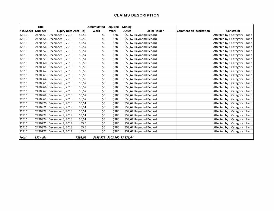
CLAIMS DESCRIPTION
NTS$SheetTitle$
Number Expiry$Date Area(Ha)Accumulated$
WorkRequired$Work
Mining$Duties Claim$Holder Comment$on$localization Constraint
32F16 2470953 December-8,-2018 55,55 $0 $780 $59,67 Raymond-Bédard- Affected-by-:--Category-II-Land32F16 2470954 December-8,-2018 55,55 $0 $780 $59,67 Raymond-Bédard- Affected-by-:--Category-II-Land32F16 2470955 December-8,-2018 55,54 $0 $780 $59,67 Raymond-Bédard- Affected-by-:--Category-II-Land32F16 2470956 December-8,-2018 55,54 $0 $780 $59,67 Raymond-Bédard- Affected-by-:--Category-II-Land32F16 2470957 December-8,-2018 55,54 $0 $780 $59,67 Raymond-Bédard- Affected-by-:--Category-II-Land32F16 2470958 December-8,-2018 55,54 $0 $780 $59,67 Raymond-Bédard- Affected-by-:--Category-II-Land32F16 2470959 December-8,-2018 55,54 $0 $780 $59,67 Raymond-Bédard- Affected-by-:--Category-II-Land32F16 2470960 December-8,-2018 55,53 $0 $780 $59,67 Raymond-Bédard- Affected-by-:--Category-II-Land32F16 2470961 December-8,-2018 55,53 $0 $780 $59,67 Raymond-Bédard- Affected-by-:--Category-II-Land32F16 2470962 December-8,-2018 55,53 $0 $780 $59,67 Raymond-Bédard- Affected-by-:--Category-II-Land32F16 2470963 December-8,-2018 55,53 $0 $780 $59,67 Raymond-Bédard- Affected-by-:--Category-II-Land32F16 2470964 December-8,-2018 55,53 $0 $780 $59,67 Raymond-Bédard- Affected-by-:--Category-II-Land32F16 2470965 December-8,-2018 55,52 $0 $780 $59,67 Raymond-Bédard- Affected-by-:--Category-II-Land32F16 2470966 December-8,-2018 55,52 $0 $780 $59,67 Raymond-Bédard- Affected-by-:--Category-II-Land32F16 2470967 December-8,-2018 55,52 $0 $780 $59,67 Raymond-Bédard- Affected-by-:--Category-II-Land32F16 2470968 December-8,-2018 55,52 $0 $780 $59,67 Raymond-Bédard- Affected-by-:--Category-II-Land32F16 2470969 December-8,-2018 55,52 $0 $780 $59,67 Raymond-Bédard- Affected-by-:--Category-II-Land32F16 2470970 December-8,-2018 55,51 $0 $780 $59,67 Raymond-Bédard- Affected-by-:--Category-II-Land32F16 2470971 December-8,-2018 55,51 $0 $780 $59,67 Raymond-Bédard- Affected-by-:--Category-II-Land32F16 2470972 December-8,-2018 55,51 $0 $780 $59,67 Raymond-Bédard- Affected-by-:--Category-II-Land32F16 2470973 December-8,-2018 55,51 $0 $780 $59,67 Raymond-Bédard- Affected-by-:--Category-II-Land32F16 2470974 December-8,-2018 55,51 $0 $780 $59,67 Raymond-Bédard- Affected-by-:--Category-II-Land32F16 2470975 December-8,-2018 55,5 $0 $780 $59,67 Raymond-Bédard- Affected-by-:--Category-II-Land32F16 2470976 December-8,-2018 55,5 $0 $780 $59,67 Raymond-Bédard- Affected-by-:--Category-II-Land32F16 2470977 December-8,-2018 55,5 $0 $780 $59,67 Raymond-Bédard- Affected-by-:--Category-II-Land
Total 132)cells 7293,06 $153)575 $102)960 $7)876,44


![C calcareous caballing calcareous tufa calcification ... · cleavage surfaces. Calcite is also the. 27 dominant vein mineral in limestones[9]. 2. A mineral composed of calcium carbonate](https://img.dokumen.tips/doc/110x75/5f7cd53f1b9a6d34a751df30/c-calcareous-caballing-calcareous-tufa-calcification-cleavage-surfaces-calcite.jpg)