Embed Size (px)
Citation preview

May 8, 2006
NASA Report
to
Committees on Appropriations
Regarding
Potential Use of Unmanned Aircraft Systems (UAS) for NASA Science Missions

May 8, 2006 2
NASA Report to
Committees on Appropriations regarding
Potential Use of Unmanned Aircraft Systems (UAS) for NASA Science Missions
Table of Contents
I. Executive Summary .......................................................................................................3 II. Introduction....................................................................................................................4 III. Role of Suborbital Observing Systems in Earth Observation ........................................4 IV. Role of UAS within Suborbital ......................................................................................6 V. Technical Capability Overview .....................................................................................7 VI. Costs...............................................................................................................................9 VII. NASA UAS Experience to Date ....................................................................................9 VIII. Current Status of NASA/NOAA Cooperation with UAS ............................................11 VIII. Potential NASA UAS Missions ...................................................................................12
Process .........................................................................................................................12 Potential Missions ........................................................................................................14 Representative Weather and Severe Storm Missions...................................................17 Additional Missions .....................................................................................................19
IX. Agency Plans ...............................................................................................................20 X. Conclusions and Summary...........................................................................................20 XI. References and Resources............................................................................................21 APPENDIX A: NASA Mission Concepts.............................................................................23 APPENDIX A References ....................................................................................................30 APPENDIX B: NOAA Mission Concepts ............................................................................32

May 8, 2006 3
NASA Report To
Committees on Appropriations Regarding
Potential Use of Unmanned Aircraft Systems (UAS) for NASA Science Missions
I. Executive Summary This report was prepared by the Science Mission Directorate of the National Aeronautics and Space Administration (NASA), in consultation with the National Oceanic and Atmospheric Administration (NOAA). This report responds to direction included in the Conference Report accompanying H.R. _2862, the FY 2006 Science, Departments of State, Justice, Commerce, and Related Agencies appropriations bill, to report on the potential use of UAS to operate in the near space environment for a variety of science and operational missions.
Both NASA and NOAA agree that the use of UAS presents opportunities for new scientific research and the potential to improve scientific outcomes. There is also the potential for interagency collaboration to increase scientific output and productivity. NASA and NOAA have already been working together in this area for several years, including two joint missions conducted in the past year. The overall missions and goals of the two agencies differ, however, and so each has a unique strategy for the use of UAS in the future. NASA’s mission statement is focused on science outcomes, whereas NOAA’s mission statement emphasizes operational functionality. This report therefore focuses on the missions which meet NASA goals in research and applied science, while noting the synergy with NOAA.
NASA has been experimenting with the use of UAS in Earth science missions over the last decade. Because actual experience has not demonstrated reduced costs, and because the potential for reduced cost appears to be associated with routine, operational missions that are still in the future, NASA has specifically been seeking to identify science missions for which UAS provide a unique measurement capability. In many appropriate cases, UAS capabilities bridge the gap between conventional aircraft and satellite capabilities. In other cases, UAS complement the capabilities of manned aircraft and the satellite-based sensor web. UAS have a potentially transformational role in the Global Earth Observation System of Systems (GEOSS), an international program directed to observe and understand the changing Earth environment. In summary, UAS are best used to extend and augment, not replace, the current observing capabilities from aircraft, surface, and satellite.
Through a series of data-gathering workshops and studies, NASA has developed a compendium of potential UAS-based mission concepts which address high-priority science requirements. These mission concepts may be used to develop a strategic road map for UAS development and application.
May 8, 2006 4
II. Introduction This report was prepared by the Science Mission Directorate of the National Aeronautics and Space Administration (NASA), in consultation with the Office of Marine and Aviation Operations and the Office of Atmospheric Research of the National Oceanic and Atmospheric Administration (NOAA). This report responds to direction included in the Conference Report accompanying H.R. 2862, the FY 2006 Science, Departments of State, Justice, Commerce, and Related Agencies appropriations bill.
“The Conferees note that over the past several years the technological maturity of the United States manufactured unmanned aerial vehicles (UAVs) has increased substantially. The Conferees believe that UAVs offer NASA a potentially low cost alternative to traditional research and operational missions, thereby opening up new opportunities for research that do not currently exist, and possible improvements in weather and severe storm prediction capabilities. Therefore, the Conferees direct the NASA Administrator, in consultation with the National Oceanic and Atmospheric Administration (NOAA), to report to the Committees on Appropriations on the potential use of UAVs to operate in the near space environment for a variety of science and operational missions. ”
Both NASA and NOAA agree that the use of UAS presents opportunities for new scientific research and the potential to improve scientific outcomes. There is also the potential to work together, to avoid duplication of efforts, and to increase scientific output and productivity. NASA and NOAA have already been working together in this area for several years. The overall missions and goals of the two agencies differ, however, and so each has a unique strategy for the use of UAS in the future. NASA’s mission statement [1], “To pioneer the future in space exploration, scientific discovery, and aeronautics research,” guides NASA’s use of UAS according to observational needs of focused, discovery-oriented science research missions, with the science missions being formulated from NASA science roadmaps and competitively selected. NOAA’s mission statement [2] is “To understand and predict changes in the Earth’s environment and conserve and manage coastal and marine resources to meet our Nation’s economic, social, and environmental needs.” Following this mandate, NOAA’s Unmanned Aircraft Systems Steering Committee has authored and approved a NOAA UAS Project Charter that guides NOAA’s use of UAS according to critical gaps in the nation’s Earth observing system. NASA’s mission statement is focused on science outcomes, whereas NOAA’s mission statement emphasizes operational functionality. This report will focus on the missions that meet NASA goals in research and applied science, where applied science is defined to serve society’s needs through benchmarking new capabilities.
NASA and NOAA have recently adopted the Federal Aviation Administration’s (FAA) acronym for this new technology – Unmanned Aircraft System (UAS), instead of the term UAV. As compared to traditional manned aircraft, this emerging technology includes the aircraft, the ground control station, and the communications links needed to positively control the platform. Throughout this document, the nomenclature “UAS” is used.
III. Role of Suborbital Observing Systems in Earth Observation Comprehensive Earth observations require multiple vantage points, each providing a unique and necessary perspective for understanding and prediction of the Earth system. The role of the suborbital
May 8, 2006 5
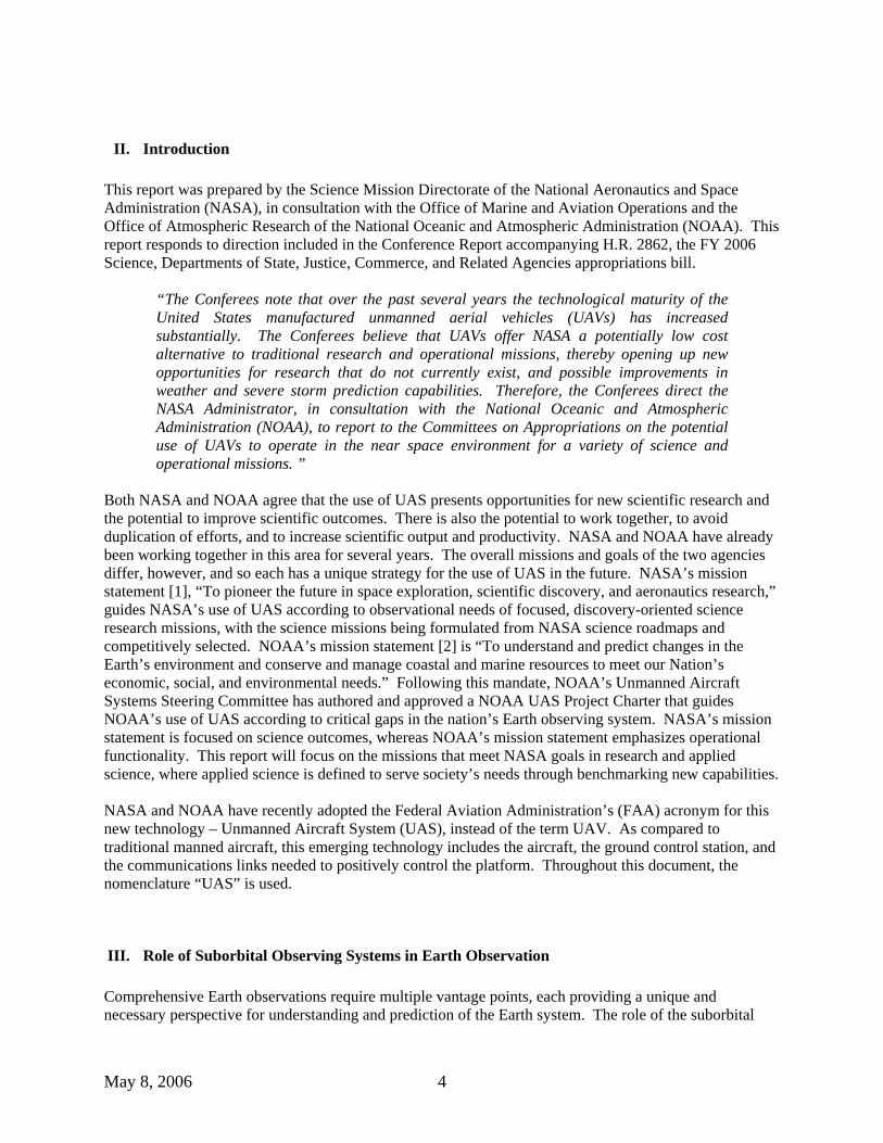
perspective is multi-faceted, but focused on exploiting the inherent properties of the suborbital platform: presence within the atmosphere, combined vertical and horizontal mobility/range, and recoverability. In addition to the increasingly capable Unmanned Aircraft Systems (UAS), suborbital platforms include conventional aircraft, sounding rockets, airships and balloons. The range and variety of capabilities represented by the systems is extensive: a single platform will support observations in the vertical dimension from surface to the outer reaches of the Earth’s atmosphere, and in the horizontal dimension from point measurements to near-continental areas.
Suborbital Flight CapabilitiesSuborbital Flight Capabilities
DC8
GHPr
L
P3
00 40004000 80008000 1200012000Range (nm)Range (nm)
00
1010
2020
3030
Alti
tude
(km
)A
ltitu
de (k
m)
Payload is proportional to font size (truncated at 2000 lb. and 600 lb.)Bold indicates payload greater than 2000 lb.
Payload is proportional to font size (truncated at 2000 lb. and 600 lb.)Bold indicates payload greater than 2000 lb.
Tropical TropopauseTropical Tropopause
Polar TropopausePolar TropopauseTroposphereTroposphere
Syno
ptic
Sca
leSy
nopt
ic S
cale
Plan
etar
y S
cale
Plan
etar
y S
cale
StratosphereStratosphere
Wal
ker
Cir
cula
tion
Wal
ker
Cir
cula
tion
ITC
Z W
idth
ITC
Z W
idth
Mes
osca
leM
esos
cale
Convective DetrainmentConvective Detrainment
Boundary LayerBoundary Layer
GH = Global HawkPr = ProteusL = Lear JetRed= UAV
GH = Global HawkPr = ProteusL = Lear JetRed= UAV
Performance Envelope
Performance Envelope
ALTAIR
WB57ER2
SVCSVC
Max. polar O3 lossMax. polar O3 loss
AL-II
AL-IH
At NASA, the suborbital vantage point is used to establish local-to-global connections between global satellite-based observations and small-scale local observations: in-depth process studies, such as this year’s Intercontinental Chemical Transport Experiment (INTEX-B) or last year’s Tropical Clouds Systems and Processes experiment (TCSP), and investigate processes through intensive, targeted observing campaigns of atmospheric processes combining in-situ and remote-sensing data, over extended areas. (INTEX-B will gather data from the Gulf of Mexico up the west coast of North America to Alaska, and out into the Pacific Ocean.) The resulting datasets are used to evaluate and improve predictive models which are initiated using satellite data. The flexibility of suborbital platforms enables targeted observations of ephemeral phenomena (for example, hurricanes) with variable temporal and spatial scales, and supports development of new space-based sensors and new remote-sensing techniques. Suborbital observations are also essential for satellite calibration/validation, through their ability to fill the gap in scale and coverage between the satellite and ground-based observing systems, as well as to gather atmospheric in-situ data. Both NASA and NOAA are working with international and domestic partners to cost-effectively increase the number, breadth, accuracy, and availability of Earth observation systems. GEOSS (Global Earth Observation System of Systems) is an international effort currently underway to link Earth observing systems and to provide us with a tool for understanding how these systems interact so that will have a truly comprehensive coverage. Nearly sixty countries have adopted a 10-year strategic plan for developing GEOSS. It stems from the idea that in order to predict, manage and observe conditions here on Earth, we need a system as complex and interconnected as the Earth itself. Today, for example, there are many observation points in place to predict and monitor hurricanes. Satellites, surface measurement systems (buoys, tide gauges) and aircraft come together to give a comprehensive picture of conditions surrounding a hurricane. This information helps improve predictive ability, giving people greater and more accurate warnings and saving lives.

May 8, 2006 6
The goal of GEOSS is to provide this information worldwide. The suite of suborbital platforms is intrinsic to the success of GEOSS, as indicated in the following diagram.
IV. Role of UAS within Suborbital The Earth observation community has long recognized the potential of UAS to extend the spatial and temporal coverage of conventional aircraft observations. The potential of robotic aircraft to extend the range and altitude of Earth atmospheric observation was discussed by the scientific community as early as 1988 at a scientific conference in Truckee, CA. [3] Several requirements-oriented workshops and meetings bringing together aeronautical engineers and Earth scientists have followed regularly through the years since. The workshops led to programs to adapt UAS to Earth observation at both NASA and the Department of Energy, and scientists at both agencies have been experimenting with UAS use since the early 1990’s. [4,5] A key point learned from these workshops and actual mission experience has been that UAS cannot unilaterally replace existing aircraft platforms. In today’s suborbital capabilities, a high-altitude platform, such as the ER-2 or WB-57, enables a class of observations not possible from the lower-altitude platforms: each platform provides a unique set of data and one cannot replace another. Similarly, an unmanned platform uniquely enables observations not possible from any of today’s more traditional aircraft. Following the hurricane observation example again, the high-altitude NASA ER-2 enables high-spatial and temporal resolution observations from above the storm as well as full-profile in-situ observations from high-altitude dropsondes, while the NOAA “Hurricane Hunter” gathers data from the center of the storm. Neither platform can gather data from the boundary layer which most affects people, simply because survivability of the aircraft at that altitude is unlikely. It is in this capacity that an unmanned platform provides a unique capability: small, expendable vehicles (with similarly expendable sensors) can fly into this boundary layer while over the ocean without endangering an onboard pilot.

May 8, 2006 7
Fundamentally, UAS fill the niche of observations which are ‘dull, dirty, or dangerous:’ dull because they allow for long transit times and routine, repetitive observations opening new dimensions of persistent surveillance and tracking; dirty because they can be sent into contaminated areas such as chemical plumes; dangerous because they can go into hazardous areas or fly missions that would endanger a pilot through exposure to extreme environments. High altitude long endurance (HALE) UAS can play a key role by making observations within the short time space scales associated with many meteorological events, in particular those that are impractical to observe using manned aircraft due to a combination of risk and limited endurance or range. Using HALE UAS technology, persistent observations can be made of distant events or phenomena, and on a far more regular and automated basis than possible using manned aircraft. In addition to flying in the near space environment, UAS platforms have an important role to play in the low-altitude regime. The planetary boundary layer, a region extending from the surface to 100-3000m, plays a fundamental role for the Earth system through exchange of heat, momentum and moisture, but the small scale of the physical processes are difficult to parameterize in models. Field studies are used to improve understanding of the processes, but require an extensive range of spatial and temporal scales to be effective. Aircraft measurements can address the problem, but flights at low altitude expose both pilots and instrumentation to risk. UAS and suitable sensors designed for expendability or survivability will add a new dimension to planetary boundary layer research. UAS are seen by the scientific community as a valuable part of the Suborbital Toolbox, with significant unique features, that will be most productively used to augment current observations. Indeed, future science campaigns are expected to make use of manned aircraft, unmanned aircraft systems, and satellite measurements, all in concert.
V. Technical Capability Overview There are numerous UAS in various stages of production, from fully operational to laboratory experiments. They range in size and capability from micro-UAS to the HALE Global Hawk.
UAS have demonstrated potential for greatly expanded observational capability, but use by the science community in actual missions has shown that they are not ready for routine civil use. While the science missions using UAS have been, in general, successful, vehicle-related issues and problems have had to be addressed in all cases. In early demonstrations the UAS flights were limited to engineering demonstrations because of airspace or reliability issues, leaving the targeted scientific datasets to be collected from traditional platforms. A more recent example is the joint NOAA/NASA UAS Mission with the Altair UAS. The mission was scheduled for April 2005, but experienced a 6-month hiatus when the communication system failed to operate at altitude and required extensive trouble-shooting and rework. Other problems delaying or reducing the effectiveness of individual flights included problems with the fuel system and the failure of the Skyball video observation system at altitude due to extreme environmental conditions. The mission did not complete until November 2005, and had to abandon some of its scientific objectives because the targeted meteorological phenomena – being a seasonal occurrence – were no longer available. Challenges to UAS becoming mission-capable enough for routine use by the science community include: • Platform, control and communications reliability • Over-the-horizon satellite communications
May 8, 2006 8
• Access to the National Airspace • Sensor development and integration on unmanned platforms • Autonomy and intelligent mission management • Costs (addressed in Section VI) Reliability
Of the UAS systems that are available for scientific or civil use, none has yet demonstrated routine, reliable performance. This is because as systems, UAS are still immature with limited flight opportunities compared to the traditional airframes. Many design or performance issues are still to be worked out. Also, because many of the systems or subsystems have been adapted from military systems that fly under different operating conditions, science teams who have used UAS find that the actual performance for meeting their scientific objectives varies, so that near-term science UAS missions still have a large element of assessment and evaluation of vehicle system performance. [6]
Over-the-horizon communication
Most of the proposed and potential uses of UAS require over-the-horizon command and control. In a typical science mission, the aircraft will not be simply sent out to gather predetermined data and return, without constant knowledge of its location. In addition, many scientific missions will benefit greatly from real-time data feedback from the payload on board the aircraft. Thus, reliable, high bandwidth satellite communication links are required. The current connectivity, while constantly improving, is not entirely reliable and not always or everywhere available.
Access to the NAS While technological maturity of UAS has increased, the airspace safety and regulatory environment must still advance before UAS can safely fly in the National Airspace (NAS) with traditional air traffic. FAA regulations are still being determined, and the detect/see-and-avoid technologies are still being developed. At this time, only one UAS has an experimental type certificate from the FAA (awarded only recently), and access to the NAS requires comprehensive flight planning significantly in advance of the actual mission. Since suborbital missions often target ephemeral phenomena, substantial planning effort may be expended for limited return.
Payload compatibility Sensor payloads that fly on UAS platforms must be designed to exploit the properties of an unmanned platform. First and foremost, the sensors must operate either autonomously or remotely. They must also be designed for the environment of near-space, since temperature and pressure control is often not provided. They must often also be designed for long duration operation. Finally, for the ‘dangerous’ class of mission, sensors must be either expendable or survivable for later recovery in the event of UAS loss. Since many UAS platforms have limited payload capability, instruments must also be miniaturized. In a sense, UAS-compatible sensors are much more like satellite sensors than many traditional aircraft sensors.
Autonomous Operation and Intelligent Mission Management UAS typically operate in a combined mode of autonomous operation and remote control. A pilot is almost always somewhere in the loop, but the most efficient operations will be those with more autonomy built into the system. Autonomy applies both to the basic functions of the aircraft and to the
May 8, 2006 9
accomplishment of mission objectives through operation of the onboard payloads. Efforts to build autonomy into the aircraft functions are underway, many based on military programs. Efforts to build intelligence into scientific missions are only in their infancy. The connection to the global sensor web while serving the end users goals has the potential for significant increases in mission productivity.
While these problems have induced skepticism within the scientific community, these challenges are all seen as workable, and many scientists remain enthusiastic over UAS potential. They simply recommend that we proceed with caution, addressing problems and issues as they arise, and that we should expect scientific return from these systems to start at a low level and increase gradually as both the challenges are overcome, and the scientific community learns to use the new capabilities to greater advantage.
VI. Costs UAS have not yet demonstrated they are lower-cost alternatives to traditional manned platforms - either in military or civilian application. [7] UAS platforms are still in their infancy stages with respect to civilian government research projects, and at this point costs are generally expected to be higher than for manned aircraft. NOAA and NASA believe, however, joint efforts can defray costs, as can multi-mission or multi-agency projects during which multiple requirements can be addressed on a single mission - as demonstrated with the 2005 NOAA/NASA Altair project. The costs of purchasing a UAS platform range from around a hundred thousand dollars to tens of millions of dollars, depending upon the aircraft performance requirements. One of the findings of the study “Cost and Business Model Analysis for Civilian UAS Missions” from Moire, Inc. [8] (commissioned by NASA in 2004) was that for the foreseeable future, the cost-per-hour-per-pound-of-payload will be at least an order of magnitude larger for a UAS compared to a comparable conventional manned aircraft. For the science community, this additional cost is acceptable when the platform is used to gather data not otherwise accessible by manned aircraft (because of safety concerns or aircraft performance limitations), but makes no sense if the mission could be accomplished as easily with a conventional platform. Therefore, UAS-based missions are not likely to replace traditional manned aircraft missions in the near future, but will instead complement and enhance them by providing unique datasets. In the future, the path to affordability includes several crucial steps. First and foremost, there needs to be more competition among UAS providers. The next most important step is to make access to the U.S. National Airspace System (NAS) the same as for manned aircraft, so UAS flights can be routine. Other cost drivers include the cost of over-the-horizon (OTH) satellite communications time and insurance. In the longer term, proliferation of satellite communications and innovative purchasing strategies should drive the OTH costs down. Aircraft and liability insurance for UAS will only decrease as the reliability of these systems is proven with safe performance.
VII. NASA UAS Experience to Date NASA and NOAA have been exploring the utilization of Unmanned Aerial Systems in Earth science research for over the past decade. UAS have already been utilized in several NASA and NOAA missions, as well as in focused experiments by the Department of Energy and the National Science Foundation. Some of those programs are listed in Table 1 below.
Table 1. UAS Science Mission Experience Project Sponsor Dates Aircraft Mission description

May 8, 2006 10
Environmental Research and Sensor Technology (ERAST) [9]
NASA 1995 - 2003 Raptor Perseus Pathfinder Helios Altus Altair
Technology Demonstrations
Atmospheric Radiation Monitoring (ARM) [4]
DOE / NASA 1994 - present Gnat, Altus Clear air radiation measurements and profiles
UAV Science Demonstration Projects [5]
NASA 2001 - 2003 Altus
Cumulus Electrification measurements
UAV Science Demonstration Projects [5]
NASA 2001 - 2003 Pathfinder Plus Coffee field ripeness / harvest optimization
Camex 4 [10] NASA 2002 Aerosonde Meteorology FiRE [11] NASA 2001 Altus Wildfire imaging
demonstration Channel Islands [6]
NOAA / NASA 2005 Altair Coastal mapping, ocean color, atmospheric chemistry
Ophelia [12] NOAA / NASA 2005 Aerosonde Hurricane operational intensity forecast
WRAP Small UAV demo [13]
NASA 2005 MLB Bat, APV-3, RMAX
Tactical fire imaging demonstration
TCSP, Costa Rica [14]
NASA 2005 Aerosonde Cloud science, hurricane genesis
MAC, Maldives NSF/NOAA/NASA 2006 (ongoing)
ACR Manta Cloud physics
Beginning with the Environmental Research and Sensor Technology (ERAST) program of the 1990’s, NASA has promoted the use of UAS in science missions. Under this program, the foundations of today’s science UAS were planted. The Perseus, Altus, and Altair were fixed-wing, consumable-fuel aircraft sponsored by this program. The solar-powered Pathfinder and Helios were also products of ERAST. Continuing with the UAV-based Science Demonstration Program (UAVSDP) of 2000, NASA put the Altus and Pathfinder Plus to work demonstrating the study of cloud electrification and crop ripeness, respectively.
More recently, the SMD has included competitively-selected UAS components in science field campaigns. In 2002, the Convection and Moisture Experiment (CAMEX) and its 2005 follow-on Tropical Cloud Systems and Processes (TCSP) research campaigns both included a UAS component. The Wildfire Research and Applications Partnership (WRAP), sponsored by NASA’s Applied Science program in conjunction with the US Forest Service, has tested several small UAS. Two joint NOAA/NASA missions were conducted in 2005 with UAS: 1) the Altair NOAA UAS Demonstration Mission, and 2) the ground-breaking flight of the Aerosonde UAS into Tropical Storm Ophelia on September 16, 2005. These cooperative missions were accomplished in partnership between NOAA, NASA and industry.

May 8, 2006 11
The mission demonstration with the UAS platform Altair covered two periods April/May and November 2005. It was a joint project with participation from NOAA’s National Ocean Service (NOS) and the Earth System Research Laboratory (ESRL) of the Office of Ocean and Atmospheric Research (OAR), the SMD Suborbital Science Program through the Earth Science Capabilities Demonstration Project/Dryden Flight Research Center (DFRC), and General Atomics Aeronautical Systems, Inc. (GA/ASI). NOAA/NOS provided project management, a principal investigator from the National Geodetic Survey for coastal mapping project using the Digital Camera System (instrument provided by NASA DFRC), and a principal investigator of the marine enforcement and marine mammal survey projects from the National Marine Sanctuary Program using the Electro-Optical InfraRed sensor provided by GA/ASI and the US Air Force. ESRL contributions to this project include ground-based support from the Trinidad Head Observatory and on-board instrumentation for ozone, halocarbons, nitrous oxide, and sulfur hexafluoride from its Global Monitoring Division, on-board instrumentation for ocean color (chlorophyll-A) as an indicator of CO2 uptake by oceanic plants and water and temperature vertical profiling by its Physical Sciences Division, integrated with project management from its Global Systems Division and scientific support from its Chemical Sciences Division. There were eight flights in the April/May period (test flights and one Channel Island flight), and three flights in the November period (test flight, 20-hour flight to the NOAA/ESRL/GMD station in northern California at Trinidad Head, another ~8 hour Channel Island flight, and one test flight). On September 16, 2005, NOAA scientists from the Atlantic Oceanography and Meteorological Laboratory, NASA scientists from Goddard Wallops Flight Facility, and engineers from Aerosonde North America launched a small Aerosonde UAS into a minimal hurricane, tropical storm Ophelia. Aerosonde flew a ten-hour flight with altitudes as low as 150 meters (500 ft). The Aerosonde platform was specially outfitted with sophisticated instruments used in traditional hurricane observation, including instruments such as mounted Global Position System, drop wind-sondes and a satellite communications system that relayed information on temperature, pressure, humidity and wind speed every half second in real-time. The Aerosonde also carried a downward positioned infrared sensor that was used to estimate the underlying sea surface temperature.
VIII. Current Status of NASA/NOAA Cooperation with UAS A Memorandum of Agreement is currently in review at NASA, NOAA, and Department of Energy (DOE) to establish a formal partnership in the area of UAS research. In addition, NASA is working with several civil agencies to determine applicability of UAS for a variety of science and operational missions. A series of multi-agency workshops are underway and results are being documented in a Civil UAS Assessment Report being created by NASA. So far, the communities who have engaged in the workshops include the weather research, climate, land-use and coastal resources communities.
NASA has also facilitated access by the science community to UAS, and is working with UAS subsystems to enhance mission capability. As indicated previously, two joint NOAA/NASA missions were conducted in 2005 with UAS: the Altair NOAA UAS Demonstration Mission and the Aerosonde UAS into hurricane Ophelia. These cooperative missions were accomplished in partnership between NOAA, NASA and industry. A third mission to which NASA and NOAA are contributing jointly with NSF is the Scripps Institution of Oceanography’s Maldives Autonomous Unmanned Aerial Vehicles Campaign (MAC), which is flying in the Indian Ocean throughout this month (March 2006). NOAA and NASA scientists are also collaborating to develop UAS-compatible payloads for future missions. Additional benefits of the NOAA and NASA investments in UAS will be realized through the Research and Operations activity, a robust NOAA-NASA partnership to systematically transition NASA Earth-Sun System research results to NOAA operational use; and to facilitate use of NOAA operational capabilities to support NASA research goals. This bilateral process has recently been formalized with Terms of

May 8, 2006 12
Reference that include suborbital/airborne capabilities as system components that are candidates for transition.
VIII. Potential NASA UAS Missions The Earth Science community is eager to use new UAS capabilities and the agencies are working together to determine best use through established, community-based, peer-review processes. The expense is especially justified when the unique capabilities are used to augment or enhance Earth observation datasets with new data. This section describes the process by which mission concepts (and corresponding requirements), for missions best performed with a UAS, have been collected. It then contains descriptions of some of those missions that have the potential for new or improved opportunities in Earth observation, with emphasis on those missions related to severe weather and storm prediction.
Process The NASA Suborbital Science Program, which supports science missions using aircraft and UAS, was restructured in FY2004 to optimize science return while simultaneously investing in UAS. The first step was to engage the science community to determine the best application of UAS for Earth science, through workshops and the peer review process. In 2004 NASA held a community workshop called “Suborbital Science Missions of the Future” [15] for all six of NASA's Earth science focus areas that was dedicated to designing future UAS-based missions. Additional workshops were held, several jointly with NOAA and DOE to further develop UAS mission plans. The various workshops are described in Table 2 below.
Table 2. Workshop Activities to Derive UAS Mission Concepts and Requirements Workshop Title Sponsor Location and
Date Website Address
Civil UAS Assessment NASA Document in preparation
http://www.nasa.gov/centers/dryden/research/civuav/index.html
Suborbital Science Missions of the Future
NASA Earth Science Enterprise
Arlington, VA; July 2004
http://geo.arc.nasa.gov/uav-suborbital/workshop.html
Suborbital Science Missions of the Future, Part 2
NASA Earth Science Enterprise
New Hampshire, (INTEX team)
Included in above
Climate Change Workshop 1
NASA / NOAA / DOE
Scripps Institute; August 2004
http://www.fsl.noaa.gov/uav_workshop/uav_workshop1/index.html
Climate Change Workshop 2
NASA / NOAA / DOE
Boulder, CO; December 2004
http://www.fsl.noaa.gov/uav_workshop/uav_workshop2/index.html
Sensor workshop NASA Civil UAV Assessment
Akron, OH; April, 2005
http://www.innovationlabs.com/uav3/
Homeland Security applications
NASA Crystal City, VA; July 2005
http://www.nasa.gov/centers/dryden/research/civuav/dhs_docs.html
Land Management and Coastal Zone Dynamics
NASA, Cal State
Monterey, CA; July 2005
http://innovationlabs.com/uav5/

May 8, 2006 13
University Climate Change Workshop 3
NASA / NOAA / DOE
Las Vegas, NV February-March, 2006
http://uas.noaa.gov/workshops/workshop3/
The mission concepts were then studied to determine the system requirements to accomplish these missions using UAS. The outcome of the requirements analysis is being documented by NASA in a Civil UAS Assessment [16], which seeks to create a roadmap for relevant technology development. The objectives of the Civil UAS Assessment activity are to: • To determine and document potential future civil missions for all UAS based on user-defined needs • To determine and document the technologies necessary to support those future missions • To discuss the present state of the platform capabilities and required technologies; identifying those in
progress, those planned, and those for which no current plans exist, i.e., to find the gaps • Provide the foundations for development of a comprehensive civil UAS roadmap
The structure of the study is designed to complement the Office of the Secretary of Defense UAS Roadmap. It is being developed in collaboration with NOAA, DOE, DOD and other agencies. The application areas being addressed are: Earth Science, Land Management, Homeland Security and Commercial uses. The figure below provides a graphic representation of the components for a typical UAS System depicting some of the capabilities needed and the enabling technologies required for performing a given mission. The many areas of technology needing to be addressed are shown in the following figure.
Beyond Line of Sight
Line of Sight
Control System
SATCOM Link
A UAV System includes:1. Air Vehicle and payloads2. Communications Architecture3. Command & Control System
User Community
UAV
Enabled by: Autonomous Mission Manageme nt, Reliable Flight Systems, NavigationAccurate Systems, Terra in Avoidance, Power and Propulsion

May 8, 2006 14
Deploy /Retrieve
VerticalProfiling
Access toThe NAS
ContingencyManagement
Over-the-HorizonCommunication
Outside Cmd.And Control
Long Rangeand EnduranceFormation
FlightMulti-ShipOperation
PrecisionState Data
QuickDeployment
TerrainAvoidance
PrecisionTrajectories
RemoteBases
UAV Missions
CollisionAvoidance
AutonomousMission Mgmt .All
Weather
HighAvailability
ReliableFlight Systems
Intell. VehicleSystem Mngmt
- Possible Development Gap
Frequency of Occurrence:HighMediumLow
LowAltitude High
Altitude
In addition to the workshop effort, the Suborbital program funded two directed studies through the Science Missions of the Future activity to develop mission concepts in greater detail. One study entitled “Mission Concepts for Uninhabited Aerial Vehicles in Cryospheric Science Applications” was a focused on a set of cryospheric missions, and the other, entitled “A Suborbital Mission Concept for Eddy Covariance Measurements in the Southern Ocean Marine Boundary Layer Using Long-Duration, Low-Altitude Unmanned Aircraft,” proposed to research climate change-related measurements in the Southern Oceans by measuring carbon dioxide flux. These two studies have been published [17,18] and are summarized below.
In addition to the Civil UAV assessment, a much broader review of Earth Science priorities is being conducted by the National Academy of Sciences under the National Research Council. This Decadal Survey entitled “Earth Science and Applications from Space: A Community Assessment and Strategy for the Future” is similar to the survey conducted for Space Sciences, and will provide a peer-reviewed roadmap for determining priorities for future investments. As part of the survey, a Request for Information (RFI) was issued to solicit ideas on mission concepts that help to “advance an existing or new scientific objective, contribute to fundamental understanding of the Earth system, and/or facilitate the connection between Earth observations and societal needs.” One study prepared in response to this RFI is also summarized below.
Potential Missions As a result of the process described above, many potential missions have been identified and requirements have been translated into performance needs for platform, sensor, and other systems. The potential missions serve research needs and also societal needs through applied science and operational activities. It is important to note that NASA’s efforts are concentrated on the more fundamental research and demonstration end of the spectrum, whereas NOAA’s interest is ultimately in the operational systems. One concept paper which combines the operational and research opportunities together is that prepared for the National Research Council’s decadal survey [20]. In that paper, the following missions and their usefulness were considered:
May 8, 2006 15
• Tropical cyclones: Can extended duration surveillance improve hurricane forecast intensity and tracking by using high resolution remotely sensed and in-situ observations?
• Synoptic forecasting: What improvements can be made in synoptic scale forecasting with high resolution remote sensing and in-situ observations with extended duration surveillance, particularly over the oceanic data voids?
• Air quality: Can we more clearly identify sources of pollutants and improve air quality forecasts? • Climate change: Do we understand the sources and sinks of greenhouse gases such as CO2, CH4,
and O3, and the potential for climate change? How are stratospheric ozone and ozone depleting substances changing?
• Cryospheric Observations: Can routine observations of glaciers and ice sheets provide information on past and future climate change?
• Disaster Management and Assessment: Can high resolution imagery and radar surveillance aid in disaster management and assessment?
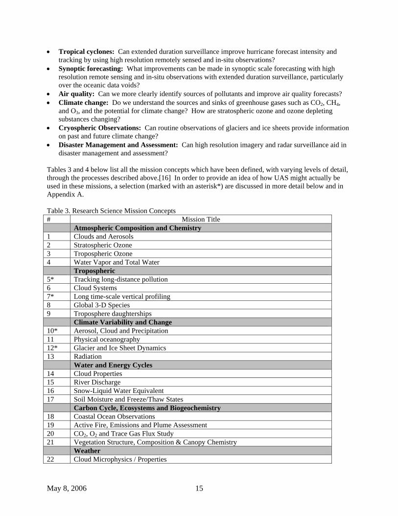
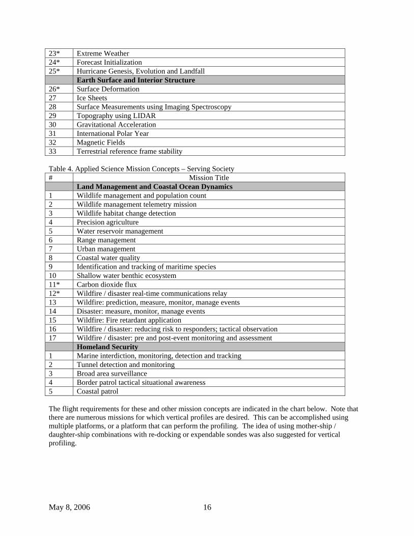
Tables 3 and 4 below list all the mission concepts which have been defined, with varying levels of detail, through the processes described above.[16] In order to provide an idea of how UAS might actually be used in these missions, a selection (marked with an asterisk*) are discussed in more detail below and in Appendix A.
Table 3. Research Science Mission Concepts # Mission Title Atmospheric Composition and Chemistry 1 Clouds and Aerosols 2 Stratospheric Ozone 3 Tropospheric Ozone 4 Water Vapor and Total Water Tropospheric 5* Tracking long-distance pollution 6 Cloud Systems 7* Long time-scale vertical profiling 8 Global 3-D Species 9 Troposphere daughterships Climate Variability and Change 10* Aerosol, Cloud and Precipitation 11 Physical oceanography 12* Glacier and Ice Sheet Dynamics 13 Radiation Water and Energy Cycles 14 Cloud Properties 15 River Discharge 16 Snow-Liquid Water Equivalent 17 Soil Moisture and Freeze/Thaw States Carbon Cycle, Ecosystems and Biogeochemistry 18 Coastal Ocean Observations 19 Active Fire, Emissions and Plume Assessment 20 CO2, O2 and Trace Gas Flux Study 21 Vegetation Structure, Composition & Canopy Chemistry Weather 22 Cloud Microphysics / Properties
May 8, 2006 16
23* Extreme Weather 24* Forecast Initialization 25* Hurricane Genesis, Evolution and Landfall Earth Surface and Interior Structure 26* Surface Deformation 27 Ice Sheets 28 Surface Measurements using Imaging Spectroscopy 29 Topography using LIDAR 30 Gravitational Acceleration 31 International Polar Year 32 Magnetic Fields 33 Terrestrial reference frame stability Table 4. Applied Science Mission Concepts – Serving Society # Mission Title Land Management and Coastal Ocean Dynamics 1 Wildlife management and population count 2 Wildlife management telemetry mission 3 Wildlife habitat change detection 4 Precision agriculture 5 Water reservoir management 6 Range management 7 Urban management 8 Coastal water quality 9 Identification and tracking of maritime species 10 Shallow water benthic ecosystem 11* Carbon dioxide flux 12* Wildfire / disaster real-time communications relay 13 Wildfire: prediction, measure, monitor, manage events 14 Disaster: measure, monitor, manage events 15 Wildfire: Fire retardant application 16 Wildfire / disaster: reducing risk to responders; tactical observation 17 Wildfire / disaster: pre and post-event monitoring and assessment Homeland Security 1 Marine interdiction, monitoring, detection and tracking 2 Tunnel detection and monitoring 3 Broad area surveillance 4 Border patrol tactical situational awareness 5 Coastal patrol The flight requirements for these and other mission concepts are indicated in the chart below. Note that there are numerous missions for which vertical profiles are desired. This can be accomplished using multiple platforms, or a platform that can perform the profiling. The idea of using mother-ship / daughter-ship combinations with re-docking or expendable sondes was also suggested for vertical profiling.

May 8, 2006 17
Altitude vs. Endurance
0
20
40
60
80
100
120
1 10 100 1000
Flight endurance, hours
1 day 2 days 3 4 5 7 10 14
Hurricane tracker(500kg)
Pollution tracking(1136kg)
Pollution tracking(900kg)
Weather forecasting(500kg)
Stratospheric ozone(1600kg)Water vapor
(545kg)
Tropospheric ozone(1000kg)
Extreme weather
Fire monitoring(180kg)
Aerosols, cloud and precip(500kg)
Clouds
Hurricane profile
Aerosols and radiation
Clouds and radiation
Fire plumeAntarctic glaciers
Carbon flux
Magnetic fields
Gravitationalacceleration
daughtership
Radiation
River discharge
3-D Global dropsondes
Volcano spectroscopy
Troposphere profileCloud aerosols
and particles
Ice sheets
Some general results of this data gathering include the following: Observatio
n Location Altitud
e Duration/Ran
ge Payload Com
m. Autonomy Other
Varied, but many groups interested in cloud physics
Worldwide; varied; including both poles, oceans and land
Surface to 80k ft.
5 hrs. to 2 weeks some loiter capability transoceanic distances
20 to 3500lb. Active and passive Dispensible In-situ and remote Smart and recoverable
Nearly all OTH Some inter- platform
Necessary, especially for tracking phenomena, including Lagrangian targeting Very applicable to planetary exploration
Many missions with multiple, coordinated platforms Frequent deployment / short turn-around
Representative Weather and Severe Storm Missions
The Conference Report specifically requested a discussion of missions focused on weather and severe storms, and two representative missions are described here. The combination of long-loiter and targeting capability of UAS make it possible to observe developing weather systems, obtain much needed detailed physics in storm environments, and improve forecasts of potentially damaging storm events. The two areas below will both benefit from targeted, extended datasets. Other missions representing suitable use

May 8, 2006 18
of UAS for research and applied science objectives extending to a wider range of federal agency goals are described in Appendix A.
Tropical Cyclone Surveillance
Atlantic tropical cyclones generally develop from westward propagating waves that form over east central Africa, move across the Atlantic and into the Pacific Ocean. Only a small proportion of these waves actually develop into hurricanes. Critical to development of these waves into tropical cyclones and then into hurricanes are the ambient conditions of the Central and Eastern Atlantic. Unfortunately, this critical development process is poorly understood, partly due to a lack of data caused by the limitations of conventional observing networks.
High-resolution observations of waves and tropical cyclones over extended periods can provide new insights into the complex interactions of mesoscale systems with the synoptic scale waves and Saharan dust moving off the African coast. Typically, in-situ cyclone observations occur only in the mature post development phase as these systems approach the United States. Lack of good vertical wind information in the early development significantly limits hurricane forecasting. Measurements of tropospheric winds, temperature, humidity fields, and sea surface temperature (SST) are needed in the Eastern tropical Atlantic during early cyclone development.
Tropical cyclone surveillance over extended periods provides critical forecast improvements to subsequent cyclone track and intensity [23]. Currently, cyclone reconnaissance is conducted using piloted aircraft operated from Florida and the Gulf Coast. The range of the aircraft limit the ability to monitor storms far out in the Atlantic. A high altitude, long-endurance (HALE) UAS would enhance these capabilities with increased range and on-station durations of 15-24 hours. Cyclone surveillance requires measurements of winds, temperature, SST, surface pressure, humidity, and cloud structure, which would be accomplished with dropsondes, lidar, radar, Visible/InfraRed multi-spectral imagery, and IR and microwave thermal and humidity profilers. These profiles would provide high vertical resolution datasets, potentially over the entire life-cycle of the storm. In addition to high-altitude extended tracking and monitoring, a tropical cyclone surveillance mission suitable to UAS is the low-altitude observations of the boundary layer, to improve scientific understanding of the air-sea interaction essential to hurricane development and intensification. The environment where the atmosphere meets the sea is where the ocean's warm water energy is directly transferred to the atmosphere just above it, feeding hurricane development and intensification. The hurricane/ocean interface also is important because it is where the strongest winds in a hurricane are found and is the level at which most citizens live. Observing and ultimately better understanding this region of the storm is crucial to improve forecasts of hurricane intensity and structure. A small UAS with extended range would fly into the storm at 300m or below, with essential measurements of winds, pressure, temperature and humidity.
Extreme Weather Focused Observations
NASA’s interest in the observation and measurement of severe weather phenomena is focused on research to improve the physics content and parameterizations in mesoscale models. Effective prediction of severe and hazardous weather events is hampered by both lack of data on the necessary scale (both temporal and spatial) and the lack of understanding of the physics involved. The processes involved in convective initiation occur on scales not resolvable from today’s observation network of satellites, surface stations and balloon-sondes. In many cases, the patterns that lead to major weather events (e.g. nor’easters and West Coast Pacific storms) initiate in data-sparse areas such as the Gulf of Mexico and

May 8, 2006 19
the northern Pacific Ocean. The suborbital toolbox can provide the necessary scale observations as well as the unique combination of remote sensing and in situ data. Access to the remote regions of the data-sparse areas or extended loitering to provide the required combination of fine temporal and spatial scale datasets can be improved by both the HALE type of UAS for an overhead view, as well as the low-altitude UAS for boundary layer observations. Process studies to improve the parameterizations for mesoscale models will enhance the assimilated datasets from current networks, and may also prove the value of routine suborbital missions for the future operational system. Crosscutting benefits include satellite validation (GPM, CloudSAT/CALIPSO, Aqua, NPOESS) and contributions to atmospheric composition measurements, especially water vapor.
The measurements to be obtained from a high altitude UAS would include cloud and precipitation properties (temperature, pressure, water vapor) electrical properties and lightning. The mission envisioned here would include an expanded follow-on to the successful Altus Cumulus Electrification Study (ACES) mission, which NASA carried out in 2002. [24] That study was focused on electrical field measurements in thunderstorms over south Florida.
The ideal UAS to provide these measurements would fly at 15 – 20 km, depending on the event, i.e, high enough to clear the storm tops with sufficient margin. The mission location would be determined by satellite and ground-based measurements used to guide the UAS to targets of interest. The advantage of using a UAS is the temporal coverage, i.e, the opportunity to provide continuous, Lagrangian monitoring over the life cycle of a storm, which could be one to two days. In addition, the endurance allows significant spatial coverage, 200 –1500 km, depending on the platform capability and the size of the event. Finally, the relatively low speed of a UAS makes it suitable for loitering.
The UAS payload would consist of a remote sensing sounder, cloud and precipitation radar, a radiometer, electrical and lightning sensors, and dropsondes for vertical meteorological measurements. A UAS with real-time data delivery links and real-time flight re-tasking capability would be used in such a mission. The connection to the sensor web, both up and down would be utilized.
Additional Missions
The following list is representative of other UAS missions which have the potential to advance NASA’s science goals and expand UAS partnerships with other civil agencies. More details are provided in Appendix A. • Surface Deformation: observations with Interferometric Synthetic Aperture Radar of seismic-related
surface deformation • Air Quality and Pollutant Plumes: measure diurnal cycle of pollutants and their transport • Stratospheric Ozone and Greenhouse Gases: extended in-situ measurements of stratospheric ozone
and other trace gases to test synoptic, regional, and global scale circulation predicted by three-dimensional models.
• Climate Change and Southern Ocean Carbon Flux: low-altitude eddy flux measurements over remote regions of the southern oceans to test hypotheses that the southern oceans are a significant sink for carbon.
• Climate Change and Glacial Ice Sheet Mass Balance: repetitive, long-range surveys in Arctic and Antarctic of ice sheet thickness with laser altimeter and radar depth sounders, to supplement and validate satellite measurements for trend analyses.
• Disaster Management: Targeted loitering missions for high spatial and temporal resolution of affected areas, tasked by satellites or other systems.
• Satellite Validation: long-range missions to follow satellite constellation tracks with synergistic payloads.
May 8, 2006 20
IX. Agency Plans NASA and NOAA are both currently investing in UAS systems. We expect to use them when scientifically justified, appropriate and safe. Ideally, UAS systems will be incorporated into planned missions and campaigns along with other platforms. This approach is consistent with the process laid out in NASA’s 2000 Report to Congress: “UNINHABITED AERIAL VEHICLE (UAV) SCIENCE DEMONSTRATION PROGRAM: A Report Outlining NASA’s Five-Year Plan for UAVs as a Scientific Platform.” [25] Where possible, NASA and NOAA will work collaboratively. Research missions, such as the INTEX-B experiment or the Maldives AUAV Campaign which are both currently ongoing, provide opportunities for the two agencies to sponsor coordinated activities. Both agencies also anticipate collaboration in an expansion of the low-altitude hurricane missions in 2006, and joint sponsorship in 2007-2008 of an Observing System Simulation Experiment to test the value of adding high-altitude UAS-based observations in operational hurricane forecast models.
NASA’s Wildfire Research and Applications Partnership project will be testing several more small UAS in a tactical wildfire demonstration, and will complete a long-duration fire reconnaissance mission in 2006 with a medium-altitude-long-endurance large UAS. A second long-duration demonstration of NASA’s Ikhana (Predator B) UAS is planned for 2007.
Upcoming EOS Aura validation missions will include a UAS component in 2007; this will offer an additional opportunity for joint NASA/NOAA research. In other areas, NASA is exploring the potential to include UAS components in the International Polar Year (see the current ROSES research announcement). NASA will also provide precision flight capability needed for repeat-pass interferometry with a UAS-compatible SAR by 2008, a capability that is anticipated to be of interest to NSF and the United States Geological Survey.
The UAS is a system will have many applications in the near future. It is important that NASA and NOAA continue to study requirements and look at the observing system alternatives to find the best sensor and platform that best meets Earth Science user requirements in the most cost efficient way.
X. Conclusions and Summary In this report, NASA is responding to the request of Congress and presenting plans for the use of UAS in science and Earth Observing Missions, consistent with previous plans and ongoing activities with UAS. Although the focus of this report is on the joint scientific interests of NASA and NOAA, UAS have the potential to advance science in areas beyond weather and severe storms, and NASA will continue to pursue partnerships with other federal agencies such as NSF, USGS and DOE, consistent with the conclusions below. • The role of the suborbital perspective is to fill the gap in scale and coverage between the satellite and
ground-based observing systems, as well as to gather atmospheric in-situ data, which is available only from the assets in the Suborbital toolbox.
• UAS are part of the Suborbital Toolbox and will augment, not replace, current observations. • UAS will have an important role in the Global Earth Observation System of Systems (GEOSS),
including the opportunity for international cooperation on severe weather forecasting and global climate predictions.
May 8, 2006 21
• UAS have demonstrated potential for greatly expanded scientific and observational capability in many dimensions of space and time, but they are not yet ready for routine, operational use. Areas requiring development include reliability, over-the-horizon communications, access to the National Airspace, payload compatibility, and autonomous operations.
• UAS have already been utilized successfully in several NASA and NOAA missions. • UAS are not yet low cost alternatives to today’s platforms. • The science community is anxious to use new UAS capabilities and agencies are working together to
determine their best use through established, community-based, peer-review processes. • Many potential science and applied science missions that would benefit from or be enabled by UAS
have been identified and requirements have been translated into performance needs for platforms, sensors, and other systems.
• NASA is investing in and using UAS where scientifically justified, appropriate and safe.
XI. References and Resources
1. National Aeronautics and Space Administration, 2006 Strategic Plan, 2006
2. NOAA UAS Charter, http://uas.noaa.gov/steering/minutes/18july2005.html
3. Langford, J., “High Altitude UAVs for Atmospheric Science: A Decade of Experience,”AIAA-2002-3467, 1st UAV Conference, Portsmouth, Virginia, May 20-23, 2002
4. Atmospheric Radiation Monitoring Website: armuav.ca.sandia.gov
5. UAVSDP Website: http://geo.arc.nasa.gov/uav-nra/index.html
6. Fahey, D. et al,“The NOAA Unmanned Aerial System Demonstration Project Using the General Atomics Altair UAS” Proc. of AIAA Infotech@Aerospace Conference, Workshop and Exhibit, Arlington, VA, 26-29 Sept. 2005.
7. United States Government Accountability Office, UNMANNED AIRCRAFT SYSTEMS: New DOD Programs Can Learn from Past Efforts to Craft Better and Less Risky Acquisition Strategies, Report to the Committee on Armed Services, U. S. Senate, March 2006
8. Moire Inc. “Cost & Business Model Analysis for Civilian UAV Missions,” August 2004. http://geo.arc.nasa.gov/uav-suborbital/
9. ERAST Website http://t2www.nasa.r3h.net/lb/centers/dryden/history/pastprojects/Erast/erast.html
10. CAMEX 4 Website http://camex.nsstc.nasa.gov//
11. Wegener S., et al, “Demonstrating Acquisition of Real-Time Thermal Date Over Fires Utilizing UAVs,” AIAA paper no. 2002-4109, 2002.
12. http://www.noaanews.noaa.gov/stories2005/s2508.htm
13 Wildfire Research and Applications Partnership: http://geo.arc.nasa.gov/sge/WRAP/
14. “Mission Summary Report: TCSP05 Aerosonde Campaign” FR# 5U015, NASA/GSFC/WFF, August 2005.
15 Schoenung, Susan, “Suborbital Science Missions of the Future Workshop Summary Report,” NASA Science Mission Directorate, March 2005. http://geo.arc.nasa.gov/uav-suborbital/
16 http://www.nasa.gov/centers/dryden/research/civuav/index.html
17. Sonntag, John G., C. Wayne Wright, William B. Krabill, “Mission Concepts for Uninhabited Aerial Vehicles in Cryospheric Science Applications,” Proc. of AIAA Infotech@Aerospace Conference, Workshop and Exhibit, Arlington, VA, 26-29 Sept. 2005.

May 8, 2006 22
18. Fladeland, Matthew M., Don Sullivan, Ronald Dobosy, and Taro Takahashi, “A suborbital observation system for measuring carbon flux over land and water,” Proc. of AIAA Infotech@Aerospace Conference, Workshop and Exhibit, Arlington, VA, 26-29 Sept. 2005.
19. http://science.hq.nasa.gov/strategy/roadmaps/index.html.
20. Newman, Paul A., Michael S. Craig, Steven C. Wofsy, Gerry M. Heymsfield, David W. Fahey, Alexander E. MacDonald, William B. Krabill, Mian Chin, William H. Brune, “Suborbital Earth System Surveillance: A mission concept for the NRC Decadal Survey,” 2005.
21. Gray, W. M., Atlantic seasonal hurricane frequency. Part II: Forecasting its variability, Mon. Wea. Rev., 112, 1669–1683, 1984.
22. Klotzback, P. J., and W. M. Gray, Updated 6–11-Month Prediction of Atlantic Basin Seasonal Hurricane Activity, Wea. & Forecast., 19, 917-934, 2004.
23. Aberson, S. D. Targeted Observations to Improve Operational Tropical Cyclone Track Forecast Guidance, Mon. Wea. Rev., 131, 1613-1628, 2002
24. http://aces.nsstc.nasa.gov/
25. “Uninhabited Aerial Vehicle (UAV) Science Demonstration Program: A Report Outlining NASA’s Five-Year Plan for UAVs as a Scientific Platform,” Cover Letter dated January 2000.
CENR/IWGEO, Strategic Plan for the U.S. Integrated Earth Observation System, National Science and Technology Council Committee on Environment and Natural Resources, Washington, DC, 2005.

May 8, 2006 23
APPENDIX A: NASA Mission Concepts
The following mission concepts are representative of the several missions defined during the NASA community workshop process described in Section VIII. While these potential missions are designed to take best advantage of the new capabilities of various UAS, actual implementation will be dependent on priorities of the science community, balanced with orbital missions and research.
Observations of Surface Deformation
Surface deformation is a symptom of a number of Earth processes. Deformation can be slow and small such as that resulting from compaction of sediments or fluid withdrawals from oil reserves and aquifers. Deformation can also be sudden and sometimes catastrophic such as that related to earthquakes, volcanoes and landslides. In addition, surface deformation is diagnostic of the accumulation of strain and its release prior to during and after seismic events. The recent combination of traditional in situ observations from geodetic and seismic networks with spatially continuous remote sensing observations of surface deformation is fueling revolutionary advances in our understanding of the geophysical processes that generate natural hazards such as earthquakes and volcanoes and hold promise for improved forecasting. This revolution has been made possible by a technique known as interferometric synthetic aperture radar (InSAR) that provides the high-resolution spatial context for the continuous but spatially disperse in situ observations. Currently, the InSAR technique has been successfully demonstrated using data from international SAR satellites that are not optimized for this purpose and therefore do not provide the requisite temporal or spatial coverage needed to fulfill the requirements of various U.S. government agencies including the EarthScope partnership of NASA, NSF and USGS. In addition, InSAR observations have recently shown that ‘glacial speed’ can actually be quite fast. A number of alpine glaciers and outflow glaciers of the Greenland and Antarctic ice sheets are accelerating and thinning at previously unknown rates. While an optimized InSAR satellite could provide the requisite global coverage for observation of surface deformation and ice flow, the orbital mechanics of a low Earth orbit would limit revisit interval to a fixed length on the order of a week or more. Much of NASA’s interest in surface deformation is event driven such as the societal impacts and consequences of catastrophic events such as earthquakes, volcanoes and landslides. These can occur at any time. An InSAR carried aboard a UAS provides the opportunity for timely response to such events when and where they occur. Long duration flight of a UAS permits observation of extended transects, the potential to dwell over or revisit ‘hotspots’ for protracted periods following an event, as well as access to remote and sometimes hostile environments such as erupting volcanoes and polar regions. In addition, the capacity of a UAS for high altitude operation provides more extensive spatial coverage for a given field-of-view thus requiring fewer flight lines. The autonomous operation of a UAS is also especially adaptable to the precision flight control system that enables the repeat-pass capability needed for the interferometry. The NASA UAVSAR program is developing an L-band InSAR for these purposes. It is the first component of the NASA contribution to the EarthScope InSAR. It is a modular design using a pod suitable for implementation on a UAS, and will be test-flown on a conventional aircraft outfitted with a new precision navigation system during FY 2007. Typical deployment scenarios for a UAS fall into three major categories: basic research, geohazards (earthquakes, volcanoes and landslides) and cryospheric studies. Examples of basic research include precision and formation flying for bistatic and multistatic SAR/InSAR research. These would typically be of short duration local flights in the US. Monitoring of geohazards will necessitate (a) periodic surveillance of known seismic and volcanic hazards such as the San Andrea fault and the volcanic belt
May 8, 2006 24
running from California through Alaska and (b) event driven response to catastrophic events requiring rapid deployment and long duration flight to provide dwell or short interval revisits over hotspots. Cryospheric deployments such as those for the artic and Antarctica will require long duration flight.
Air Quality and Pollutant Plumes The Clean Air Act of 1970 has been followed by numerous Presidential and Congressional initiatives for improving air quality in the United States. The February 2002 Presidential Clear Skies Initiative built on these efforts to improve air quality and the monitoring of air quality. Pollution sources and trans-continental transport of pollutants and aerosols are major sources of uncertainty for understanding U.S. air quality. In addition, future climate change may significantly enhance tropospheric ozone levels [26]. Aerosols are also one of the largest uncertainties in assessing climate forcing and feedbacks. However, the level of current scientific understanding of trans-continental transport and direct aerosol effects is still very low. There have been numerous field experiments in the past decade measuring aerosol concentrations and chemical/physical/optical properties, and several remote sensing instruments on satellite measuring global aerosol distributions. However, these field experiments are limited by the time and spatial coverage since they only take place in a small geographic domain with duration of a just few weeks, and the satellite measurements are limited. There are currently no routine aircraft observations of air quality in the US. In the troposphere, the variability of emission and chemical production/loss, combined with dynamic transport and mixing, cause significant short-term (< 1 hour) variations of aerosols and their precursor gases. Measurements of aerosol diurnal variability are limited to land surfaces in a few monitoring networks (e.g., air quality and visibility monitoring networks). The relatively short flight time/range of a typical aircraft during a field experiment and the “once-a-day snap shot” nature of the low-earth orbit satellite limitations have not provided satisfactory monitoring of local/regional pollution and transport. Further, ozone production is a highly non-linear function of NOx and volatile organic gases. Because of this non-linearity, fine-scale plumes result in high variability of compounds and much different ozone production rates than broadly averaged trace gas distributions. Therefore, observational resolution is critical for correctly representing and modeling tropospheric pollution. High resolution in-situ and remote sensing of NOx, ozone, and organic compounds in urban/suburban regions are vitally important for air quality forecasts and assessments. High-resolution observations from a HALE UAS could make a unique contribution to chemical weather prediction [27]. Operating a HALE UAS with aerosol and air quality measurements would complement satellite-retrieved observations. The HALE UAS is an ideal vehicle to monitor the diurnal cycle of pollutants, and their transport. Remote sensing measurements would be most applicable for use on the HALE UAS. For aerosols, a multi-spectral imager and a lidar instrument to measure total aerosol optical thickness (imager), fine mode fractions (imager), and vertical distributions (lidar) would be suitable. For pollutants, an ozone lidar, a passive remote sensing ozone and NO2 instrument, a hyperspectral UV/VIS imager for ozone and aerosols, and an infrared remote sensing instrument for observing CO and CH4 would be appropriate.
Stratospheric Ozone and Greenhouse Gases
Changes of long-lived atmospheric gases are primary drivers for both global radiative forcing and for losses of stratospheric ozone, arguably the two most important human impacts on the global environment. Most ozone depleting substances (ODSs) are more powerful greenhouse gases than CO2, although at lower concentrations than CO2. For example, based on global warming potential estimates over the 2000-2020 period, 1 kg of N2O is 278 times more effective at warming the surface than 1 kg of CO2,
May 8, 2006 25
while CFC-12 is 10,340 times more effective. To make wise policy choices, scientists must provide a quantitative understanding of processes that regulate increases in greenhouse gases (GHGs) and an understanding of the globally-distributed reactive species (CO2, CH4, N2O, O3, CO, SF6), as well important halogen species involved in climate change (CFCs, HCFCs, brominated and chlorinated organics). Our current knowledge of sources and sinks for these gases is limited by the few observations that are made in the middle troposphere to lower stratosphere region. Ground networks provide good surface data. (For example, NASA’s Advanced Global Atmospheric Gases Experiment seeks to address issues of relevant global chemical and climatic phenomena through appropriate surface observations. [28]) However, when used to drive global inverse studies, models produce divergent results for source and sink distributions. Effluent from huge geophysical events pass above surface stations, so that only indirect estimates are required to assess emissions, for example from the vast Indonesian fires of 1997, or the eruption of Mt. Pinatubo in 1991. Likewise it is difficult to determine residual emissions for regulated ozone-depleting gases emanating from major continental areas. Satellites provide good stratospheric information, but limited information in the upper troposphere and lower stratosphere. Currently, the AURA satellite provides information on the important GHGs: ozone, CFC-11, CFC-12, N2O, and CH4. The critical region for global studies is in the lower stratosphere to mid troposphere, exactly where satellite measurements of atmospheric gases are limited. The middle troposphere to lower stratosphere is the region of connection between satellite observations and the surface observations. In all these cases, we know from model studies and from short airborne campaigns that dramatic reductions in uncertainty will accrue from global measurements in the middle and upper troposphere and lower stratosphere, repeated at monthly intervals. A high altitude UAS is the ideal vehicle to make these repeated measures on a global basis, and to respond to major geophysical events. We envision flights extending from pole-to-pole, with vertical profiles at intervals from 200 to 500 km that extend from near the surface to the lower stratosphere, one cross section along the dateline and one down the middle of the Atlantic. Regular UAS flights can be used as both a transfer standard and a validation mechanism for the satellite and surface observations. UAS measurements complement ground and satellite measurements, and tie them together. The payload would consist of in situ instruments that include compact laser spectrometers, an accurate sensor for the O2:N2 ratio, an ozone sensor, compact systems for measuring a number of minor species (CO2, CH4, N2O, O3, CO, SF6, CFCs, HCFCs, brominated and chlorinated organics formaldehyde, acetone, and related species). In addition, ozone and CO2 nadir profiling lidars would be flown along with a dropsonde system for measuring temperatures and winds. All of these have been demonstrated in forms suitable for adaptation to the high altitude UAS and application to the long flights and periodic deployments envisioned here.
Climate Change and Greenhouse Gases: Southern Ocean Carbon Flux
Another issue associated with global warming is the rate of uptake or sequestration of carbon dioxide in various media or sinks. Vegetation is responsible for a large portion of the uptake. It is known that the oceans also serve as a sink, but the rate of consumption is harder to evaluate. It has been speculated that the vast southern ocean between South America and Australia may be a significant sink. But measurements of carbon flux there are infrequent and difficult.
May 8, 2006 26
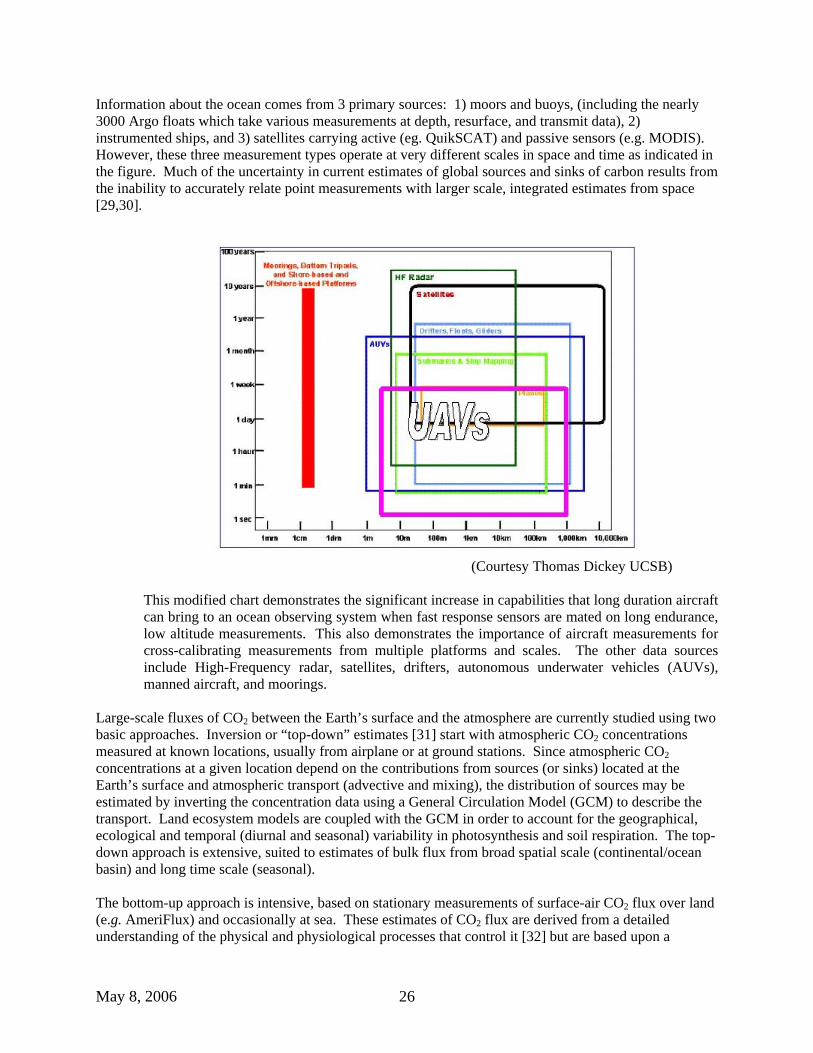
Information about the ocean comes from 3 primary sources: 1) moors and buoys, (including the nearly 3000 Argo floats which take various measurements at depth, resurface, and transmit data), 2) instrumented ships, and 3) satellites carrying active (eg. QuikSCAT) and passive sensors (e.g. MODIS). However, these three measurement types operate at very different scales in space and time as indicated in the figure. Much of the uncertainty in current estimates of global sources and sinks of carbon results from the inability to accurately relate point measurements with larger scale, integrated estimates from space [29,30].
(Courtesy Thomas Dickey UCSB)
This modified chart demonstrates the significant increase in capabilities that long duration aircraft can bring to an ocean observing system when fast response sensors are mated on long endurance, low altitude measurements. This also demonstrates the importance of aircraft measurements for cross-calibrating measurements from multiple platforms and scales. The other data sources include High-Frequency radar, satellites, drifters, autonomous underwater vehicles (AUVs), manned aircraft, and moorings.
Large-scale fluxes of CO2 between the Earth’s surface and the atmosphere are currently studied using two basic approaches. Inversion or “top-down” estimates [31] start with atmospheric CO2 concentrations measured at known locations, usually from airplane or at ground stations. Since atmospheric CO2 concentrations at a given location depend on the contributions from sources (or sinks) located at the Earth’s surface and atmospheric transport (advective and mixing), the distribution of sources may be estimated by inverting the concentration data using a General Circulation Model (GCM) to describe the transport. Land ecosystem models are coupled with the GCM in order to account for the geographical, ecological and temporal (diurnal and seasonal) variability in photosynthesis and soil respiration. The top-down approach is extensive, suited to estimates of bulk flux from broad spatial scale (continental/ocean basin) and long time scale (seasonal). The bottom-up approach is intensive, based on stationary measurements of surface-air CO2 flux over land (e.g. AmeriFlux) and occasionally at sea. These estimates of CO2 flux are derived from a detailed understanding of the physical and physiological processes that control it [32] but are based upon a

May 8, 2006 27
statistical comparison between the mean vertical wind speed, and the mixing ratio of CO2 over time [33,34]. The eddy covariance technique relies on precise measurements of winds, usually using a sonic anemometer, or more recently, LIDAR, to measure wind speed and direction up at up to 100Hz. Contemporaneous, fast-response measurements of the mixing ratios of CO2 or other constituents when combined with mean vertical velocity over time provide information on trends in carbon transport between the surface and the atmosphere. The approach attains large-scale coverage by assigning flux models to different land cover types derived from satellite data classifications [35]. Both approaches are in active development. Each approach has its own role, and together they can check each other as they progress in sophistication.
Eddy correlation methods are commonly used as an effective tool for flux measurements over land, but they have been successful for sea-air flux measurements aboard research ships only for a few deployments due to difficulties arising from small fluxes (one to two orders of magnitude smaller than the land fluxes). Nevertheless, based on measurements of the partial pressure of CO2 in seawater (pCO2), rapid changes in flux over space and time over the oceans have been observed for regions of deep water upwelling such as the equatorial Pacific and coastal upwelling zones [36]. These upwelling regions possess vigorous wind and wave action [37,38], and often have micro-fauna blooms [39,40]. Development of an airborne eddy flux measurement method sensitive enough to detect air-sea fluxes is achievable, and will likely provide a critical gap in the set of expected measurements for future research campaigns.
Suborbital assets, and UAS in particular have the potential to provide a series of important capabilities that can complement current ocean observations. A mission concept has been defined, also as part of the Science Missions of the Future program, in which a low-altitude UAS with appropriate eddy flux instrumentation, would be used to make long duration measurements at minimal distances above the ocean surface. The aircraft would base on a ship at sea, and likely communicate with a loitering UAS overhead. A detailed description of this mission has been published.[18] The figure below depicts this mission concept.
Climate Change: Cryospheric Observations / Glacial Ice Sheets
The state of mass balance of the great ice sheets covering Antarctica and Greenland reflects the effects of past and present climate change, and assessing that balance is a high priority of the NASA Cryospheric Sciences Program and US Climate Change Science Program. Foremost among needed glaciological observations are surface elevation and its change with time (using lidar) and ice thickness (low-frequency radar). Surface elevation measurements can currently be made from satellites, albeit with the limited spatial and temporal resolution inherent to observations collected from orbit. Precise lidar measurement
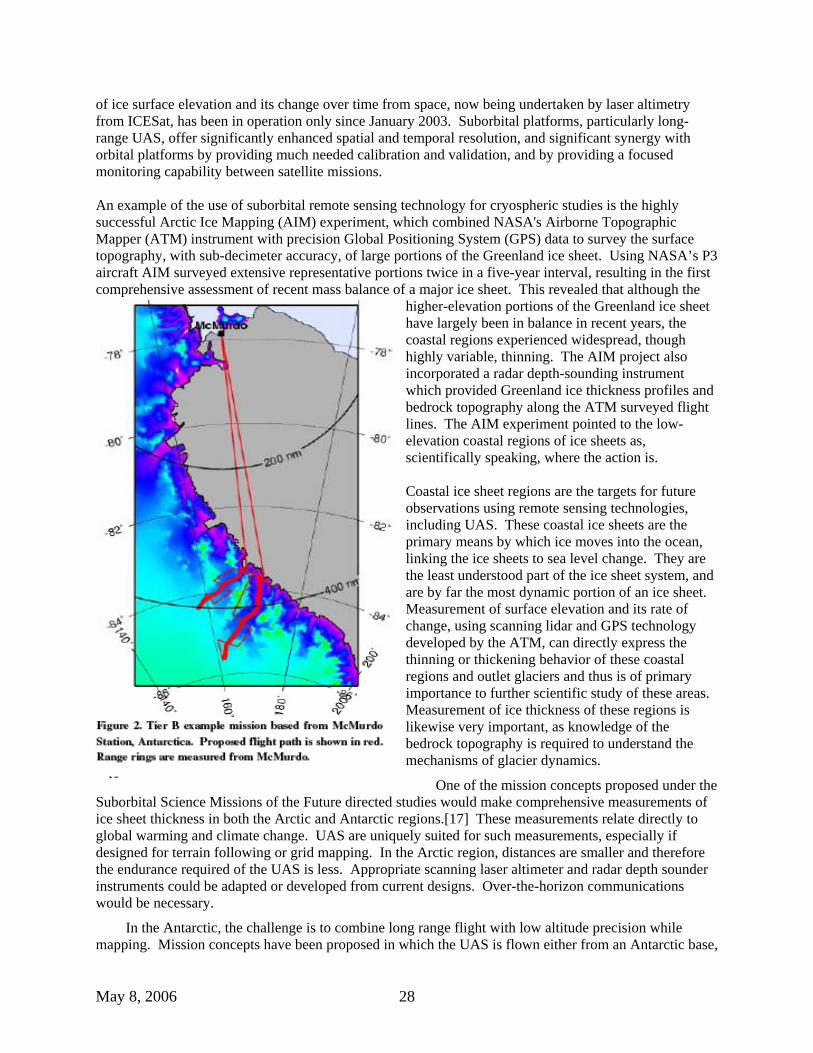
May 8, 2006 28
of ice surface elevation and its change over time from space, now being undertaken by laser altimetry from ICESat, has been in operation only since January 2003. Suborbital platforms, particularly long-range UAS, offer significantly enhanced spatial and temporal resolution, and significant synergy with orbital platforms by providing much needed calibration and validation, and by providing a focused monitoring capability between satellite missions.
An example of the use of suborbital remote sensing technology for cryospheric studies is the highly successful Arctic Ice Mapping (AIM) experiment, which combined NASA's Airborne Topographic Mapper (ATM) instrument with precision Global Positioning System (GPS) data to survey the surface topography, with sub-decimeter accuracy, of large portions of the Greenland ice sheet. Using NASA’s P3 aircraft AIM surveyed extensive representative portions twice in a five-year interval, resulting in the first comprehensive assessment of recent mass balance of a major ice sheet. This revealed that although the
higher-elevation portions of the Greenland ice sheet have largely been in balance in recent years, the coastal regions experienced widespread, though highly variable, thinning. The AIM project also incorporated a radar depth-sounding instrument which provided Greenland ice thickness profiles and bedrock topography along the ATM surveyed flight lines. The AIM experiment pointed to the low-elevation coastal regions of ice sheets as, scientifically speaking, where the action is.
Coastal ice sheet regions are the targets for future observations using remote sensing technologies, including UAS. These coastal ice sheets are the primary means by which ice moves into the ocean, linking the ice sheets to sea level change. They are the least understood part of the ice sheet system, and are by far the most dynamic portion of an ice sheet. Measurement of surface elevation and its rate of change, using scanning lidar and GPS technology developed by the ATM, can directly express the thinning or thickening behavior of these coastal regions and outlet glaciers and thus is of primary importance to further scientific study of these areas. Measurement of ice thickness of these regions is likewise very important, as knowledge of the bedrock topography is required to understand the mechanisms of glacier dynamics.
One of the mission concepts proposed under the Suborbital Science Missions of the Future directed studies would make comprehensive measurements of ice sheet thickness in both the Arctic and Antarctic regions.[17] These measurements relate directly to global warming and climate change. UAS are uniquely suited for such measurements, especially if designed for terrain following or grid mapping. In the Arctic region, distances are smaller and therefore the endurance required of the UAS is less. Appropriate scanning laser altimeter and radar depth sounder instruments could be adapted or developed from current designs. Over-the-horizon communications would be necessary.
In the Antarctic, the challenge is to combine long range flight with low altitude precision while mapping. Mission concepts have been proposed in which the UAS is flown either from an Antarctic base,

May 8, 2006 29
or from the mainland of South America or New Zealand. An example flight path is shown in the figure. The communications challenge is greater in the Antarctic because there are fewer over-the-horizon satellite communications options and they are expensive.
One or more missions based on these cryospheric measurement needs would be suitable contributions to the efforts of the International Polar Year (IPY).
Disaster Management:
Disasters such as thunderstorms, tornados, hurricanes, tsunamis, blizzards, flooding, volcanic ash, wildfires, oil spills, and earthquakes, cost the U.S. government billions of dollars every year [41]. The federal government, state, and local communities need accurate and timely environmental information to help plan mitigation and recovery strategies. NASA and NOAA Earth Science programs already provide valuable data from satellites and piloted aircraft to aid the Federal Emergency Management Agency (FEMA), U.S. Department of Agriculture (USDA), U.S. Forest Service (USFS), U.S. Geological Survey (USGS) and most recently with the Department of Homeland Security (DHS). Continued observations in this area are applicable to coastal management, community growth, public health and water management.
The Land Rapid Response System with the MODIS instruments onboard NASA’s Terra and Aqua satellites is a prime example of how NASA helps with disaster response. MODIS provides location information needed to help USFS managers locate wildfires and strategically plan their response. Although useful for the USFS, the resolution is inadequate for actual firefighters. With airborne remote sensing techniques and instruments such as the UAS-wildfire instrument, firefighters can obtain thermal IR digital data that are much higher resolution for identifying fire activity in real time. In 2001, NASA has completed a UAS demonstration mission called the First Response Experiment (FiRE) mission [11]. Current plans for a Western States UAS Fire Mission in summer of 2006 will use a new fire imaging sensor flying on the Altair. [42]
Data from NASA satellite missions also make significant contributions in the area of hurricanes and flood prediction using Tropical Rainfall Measuring Mission (TRMM) and QuikSCAT satellite observations. These observations have improved predictions of tracking, intensity, and landfall of hurricanes that could potentially endanger millions of people. As described previously, the use of UAS could enable more intensive operations for these purposes.
Large efforts are going forward with Federal, State, and local governments in Homeland Security and NASA’s measurements and observations can provide valuable information to support the risk and vulnerability assessments. Earth Science can provide many solutions with applications of air quality, water management, public health and disaster management for the DHS when required.
The payload would include imaging capability from the UV to the IR and a synthetic aperture radar (SAR). The standard Air Force HALE UAS payload includes a 10-inch telescope for common optics and a SAR. With this would be included a multi-channel IR imaging system for fire detection (e.g., UAS-wildfire instrument), a hyperspectral imager, and a lidar for plume profiling.
Satellite Validation and Research
The correct interpretation and use of scientific information from satellite data sets requires that the geophysical parameters retrieved from the remotely-sensed radiance data are validated through a variety of methods. One essential tool is the field campaign that coordinates measurements from satellites, surface and suborbital platforms, combining multiple measurement approaches and a variety of spatial and temporal scales. Most of NASA’s suborbital missions merge process investigations and satellite

May 8, 2006 30
validation; examples are the Polar-Aura Validation Experiment of 2005 where to the primary objective of Aura product validation was added others in atmospheric transport (stratospheric/tropospheric exchange, North American continent outflow), and the current Intercontinental Chemical Transport Experiment, an international science experiment to which EOS Aura, Terra, Aqua and Envisat validation objectives have been added. Validation is anticipated to be a major activity for all of NASA’s future satellites, especially for the Afternoon “A-Train” satellite constellation. The A-train consists of 6 U.S. and international satellites, flying in tandem and crossing the equator within minutes of each other about 1:30 pm local time. A HALE UAS can augment the validation activity by its long endurance and extreme range. Payloads would be designed to be synergistic with the satellite operations, providing high-resolution coincident remote-sensing and in-situ datasets, with payload changeout capability depending on the geophysical products to be validated.
APPENDIX A References
26. Zeng, G., J. A. Pyle, Changes in tropospheric ozone between 2000 and 2100 modeled in a chemistry-climate model, Geophys. Res. Lett., 30 (7), 1392, doi:10.1029/2002GL016708, 2003.
27. Dabberdt, W. F., et al., Meteorological research needs for improved air quality forecasting - Report of the 11th prospectus development team of the US Weather Research Program, Bull. Amer. Met. Soc., 85, 563, 2004.
28. http://agage.eas.gatech.edu/home.htm
29. Desjardins RL, JI MacPherson, L Mahrt, P Schuepp, E Pattey, H Neumann, D Baldocchi, S Wofsy, D Fitzjarrald, H McCaughey, DW Joiner. 1997. Scaling up flux measurements for the boreal forest using aircraft-tower combinations. JGR.102. D24:29,125-29,133.
30. Crawford TL, RJ Dobosy, RT McMillen, Vogel CA, BB Hicks. 1996. Air-surface exchange measurement in heterogeneous regions: extending tower observations with spatial structure observed from small aircraft. Global Change Biology. 2:275-285.
31. Gurney KR, RM Law, AS Denning, PJ Rayner, D Baker, P Bousquet, L Bruhwiler, YH Chen, P Clais, S Fan, IY Fung, M Gloor, M Heimann, K Higuchi, J John, T Maki, S Maksyutov, K Masarie, P Peylin, M Prather, BC Pak, J Randerson, J Sarmiento, S Taguchi, T Takahashi, CW Yuen. 2002. Towards robust regional estimates of CO2 sources and sinks using atmospheric transport models. Nature. 415:626-630.
32. Anderson, M.C., W.P. Kustas, and J.M. Norman. 2003. Upscaling and downscaling - A regional view of the soil-plant-atmosphere continuum. Agronomy Journal. 95:1408-1423.
33.Baldocchi, D.D., Hicks, B.B., and Meyers, T.P., 1988, “Measuring biosphere – atmosphere exchanges of biologically related gases with micrometeorological methods,” Ecology, 69. 5:1331-1340.
34 Baldocchi, D.D., 2003, “Assessing the eddy covariance technique for evaluating carbon dioxide exchange rates of ecosystems: past, present and future,” Global Change Biology,9:479-492.
35. Mecikalski, J.R., G.R. Diak, M.C. Anderson, and J.M. Norman 1999: Estimating fluxes on continental scales using remotely sensed data in an atmospheric-land exchange model.Journal of Applied Meteorology. 38:1352 – 1369.
36. Takahashi, T, R.A. Feely, R.F. Weiss, R.H. Wanninkhof, D.W. Chipman, S.C. Sutherland, T.T. Takahashi. 1997. Proceedings of the National Academies of Sciences, USA. Vol. 94, pp. 8292-8299.
37. Garibato ACN, KL Polzin, BA King, KJ Heywood, M Visbeck. 2004. Widespread Intense Turbulent Mixing in the Southern Ocean. Science. 303:210-213.

May 8, 2006 31
38. Bates, N.R., T. Takahashi, D.W. Chipman, A.H. Knap.1998. Variability of pCO2 on diel to seasonal timescales in the Sargaso Sea near Bermuda. Journal of Geophysical Research.108. C8:15,567-15,585.
39. Hales, B., D. Chipman, T. Takahashi. 2004. High-frequency measurement of partial pressure and total concentration of carbon dioxide in seawater using microporous hydrophobic membrane contractors. Limnology and Oceanography: Methods. 2:356-364.
40. Korb RE, M Whitehouse. 2004. Contrasting primary production regimes around South Georgia, Southern Ocean: large blooms versus high nutrient, low chlorophyll waters. Deep-Sea Research I. 51:721-738.
41. http://www.ncdc.noaa.gov/oa/reports/billionz.html).
42. Ambrosia, V. et al, “The 24-Hour UAV Western States UAV Fire Mission: Sensor and Intelligent Management Systems” Proc. of AIAA Infotech@Aerospace Conference, Workshop and Exhibit, Arlington, VA, 26-29 Sept. 2005. Other resources:
http://eospso.gsfc.nasa.gov/validation/index.php
http://aqua.nasa.gov/doc/pubs/A-Train_Fact_sheet.pdf
http://cloud1.arc.nasa.gov/ave-polar/objectives.html

May 8, 2006 32
APPENDIX B: NOAA Mission Concepts As part of our collaboration with NOAA, we collected the descriptions of their mission concepts. These are presented here with no modification. Hurricane Prediction, Tracking, Structure and Intensity Change
Hurricanes and tropical storms cause many deaths and average billions of dollars in damages each year. More than 1,000 lives were lost in Hurricane Katrina (2005) alone, and its financial impact on the United States’ economy will exceed $200 Billion. The devastation of Hurricanes like Katrina or Wilma (2005) require that we make the best possible and most authoritative information available to decision-makers in the future as they determine whether to implement mandatory evacuations and other costly actions for approaching hurricanes. NOAA is investigating new technologies, such as UAS, to improve the accuracy and timeliness of our Nation’s existing weather observation and forecast system. UAS observations could enhance our current observing network and provide critical validation for remote data obtained from global satellite systems. UAS observations could also significantly increase data coverage within the difficult to observe hurricane environment. Such enhancements should improve future forecasts of hurricane track and intensity change. The impact of enhancing our existing manned hurricane reconnaissance and surveillance capabilities with a comprehensive hurricane UAS observation network could have a tremendous national payoff in terms of saving lives, mitigating damage to property and natural resources, and saving our economy billions of dollars. Using a combination of the types of UAS outlined below should provide the cornerstone for a comprehensive UAS observation network to monitor and track hurricanes impacting the United States. It is believed that a significant in-situ observing system upgrade such as this will directly lead to improved understanding and enhanced predictive capabilities in the area of hurricane track and intensity forecasting. Such improvements could save countless lives and billions of dollars. Manned planes have not provided detailed observations of the near-surface hurricane water-air boundary-layer environment, primarily because of the safety risks associated with low altitude flights. A relatively low cost plane such as the Aerosonde could fly at these low levels, namely, at 500 feet or less within the high wind hurricane eyewall, which is thousands of feet lower than any manned aircraft could safely circumnavigate, and could collect data to fill an observational gap without putting aircrew lives at risk. This ‘potential’ recently became reality on September 16, 2005 when the Aerosonde became the first unmanned aircraft to successfully navigate into the core of a hurricane (Ophelia) of the Virginia coast and return back to base safely. Near surface winds and other boundary layer data from Ophelia were successfully transmitted to NOAA’s National Hurricane Center in real time.
Continuous observation of temperature, moisture and winds in the near-surface hurricane environment has never been documented. Monitoring this environment, where the atmosphere meets the sea, is critical because it is where the ocean's warm water energy is directly transferred to the atmosphere just above it. The hurricane surface layer is where the strongest winds are found in a hurricane and is also the level at which most of us live (i.e. at/near the surface). Therefore, observing and improving our understanding of this region of the storm is crucial if we hope to improve our ability to make accurate forecasts of hurricane intensity change. The United States has developed and currently deploys HALE (High Altitude Long Endurance) UAS for military uses, including Northrop Grumman’s Global Hawk. NOAA, NASA and the Department of
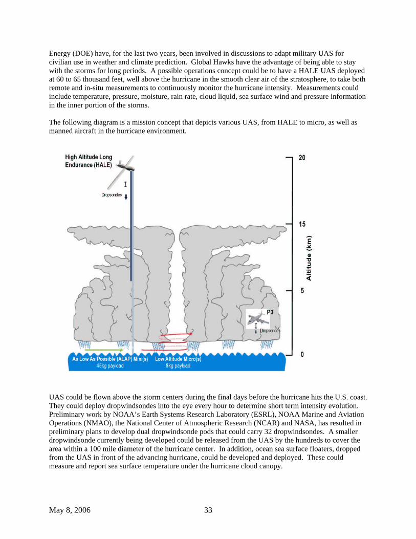
May 8, 2006 33
Energy (DOE) have, for the last two years, been involved in discussions to adapt military UAS for civilian use in weather and climate prediction. Global Hawks have the advantage of being able to stay with the storms for long periods. A possible operations concept could be to have a HALE UAS deployed at 60 to 65 thousand feet, well above the hurricane in the smooth clear air of the stratosphere, to take both remote and in-situ measurements to continuously monitor the hurricane intensity. Measurements could include temperature, pressure, moisture, rain rate, cloud liquid, sea surface wind and pressure information in the inner portion of the storms. The following diagram is a mission concept that depicts various UAS, from HALE to micro, as well as manned aircraft in the hurricane environment.
UAS could be flown above the storm centers during the final days before the hurricane hits the U.S. coast. They could deploy dropwindsondes into the eye every hour to determine short term intensity evolution. Preliminary work by NOAA’s Earth Systems Research Laboratory (ESRL), NOAA Marine and Aviation Operations (NMAO), the National Center of Atmospheric Research (NCAR) and NASA, has resulted in preliminary plans to develop dual dropwindsonde pods that could carry 32 dropwindsondes. A smaller dropwindsonde currently being developed could be released from the UAS by the hundreds to cover the area within a 100 mile diameter of the hurricane center. In addition, ocean sea surface floaters, dropped from the UAS in front of the advancing hurricane, could be developed and deployed. These could measure and report sea surface temperature under the hurricane cloud canopy.

May 8, 2006 34
Fisheries and Protected Species Research
NOAA currently does not use UAS for active fisheries or protected species research. There are a variety of missions, however, that could benefit from developing UAS monitoring and surveying methods. NOAA Fisheries collects data using a combination of platforms including satellites, research aircraft, research vessels and individual researchers on the ground. While traditional fisheries protected species data has relied on nets, and direct observations, there are data which may be more efficiently collected using UAS, such as: • Phenomena near the water’s surface (upper 10’s of meters), and on land; • Phenomena that can be sensed using optical or radar methods; and • Phenomena that are large enough, common enough, or concentrated enough to be reliably observed.
Characteristics of the survey mission that could make UAS a preferable platform over traditional vessels or aerial survey methods include: • Data collection requiring a relatively long endurance sampling effort (e.g., >6+ hrs); and • Data collection which is too dangerous for traditional sensing techniques (e.g., low altitude surveys
along cliffs).
An instrument, such as a LIDAR (light detection and ranging), mounted onboard a UAS, that has the capability of flying 20 hours or more, could enable NOAA to survey a much broader ocean area than is currently covered by manned aircraft, and could be capable to determine how many fish there are in the upper portion (i.e., 10’s of meters) of that ocean area. The sensors could potentially be used to survey a variety of pelagic fishes, such as anchovy, sardine, mackerel, and herring. Research conducted by NOAA’s Earth System Research Laboratory suggest that LIDAR techniques could also be used to survey salmon in streams and embayments and surface concentrations of zooplankton. In addition, the time saved by collecting data with a UAS as opposed to a ship-based survey, could potentially be cost effective.
Pelagic marine species, notably cetaceans and some turtle species, have been traditionally surveyed using visual observers from ships or aircraft following line or strip transects. No alternative method to visual observers has been developed to date (except for passive acoustics), but there are specific situations where a UAS equipped with an airborne survey package (e.g., digital, thermal, and perhaps LIDAR imagery), could be beneficial to better observe the following when compared to manned aircraft:
• Long endurance surveys, such as:
o Cetacean abundance surveys of areas in NOAA Fisheries Service’s Pacific Islands Region, i.e. the Northwest Hawaiian Islands;
o Surveys for beaked whales along the entire eastern continental shelf break; or o Surveys for ice seals (e.g., ringed or bearded seals) hauled out along the Bering Sea ice edge
in winter. • Night time surveys using thermal imagery; and • Focused surveys of known concentrations of whales (e.g., foraging aggregations of northern right
whales off of Cape Cod, MA).
NOAA could benefit from developing UAS survey methods. Aerial surveys tend to miss most marine mammal and turtles, so fewer animals would be seen with a UAS than with a ship. The sighting cues

May 8, 2006 35
available to a visual observer would be less obvious from photographs. Considerable person time would still be needed to review imagery post-flight. Nonetheless, because surveys under the conditions listed above are so problematic, UAS could provide an important new tool in the NOAA survey toolbox.
Aerial over-flight surveys of colonies of marine mammals, turtles and sea birds could benefit from UAS observations. These surveys are typically flown very low (~200 m) and slow (< 100 knots) in often relatively turbulent air (e.g., along cliff edges), and are therefore a higher risk for manned aircraft. In addition the twin-engine aircraft typically used for these surveys are noisy, which can disturb the colony. Therefore, a relatively small, slow, low-flying, and quiet UAS outfitted with digital still and/or video cameras could provide an ideal solution to the problem. NOAA’s Antarctic Program is discussing the potential use of a system that could involve launching and retrieving a UAS from a ship to count penguins and estimate fur seal numbers on rookeries. Similar discussions have also occurred at NOAA’s Alaska Fisheries Science Center regarding potential low altitude UAS surveys of Steller sea lions rookeries in Alaska’s Aleutian Islands.
UAS could also support tracking and/or relocation of radio-tagged mammals and turtles. Once tagged, instrumented animals disperse over a broad area and are difficult to locate. Signal strength of wildlife transmitters is low, while the area to be searched may be very broad. This combination of weak signals and broad search areas, results in a poor ability of the search flights to locate the animals. A high endurance UAS platform with a radio receiving system, uplinked to a ground station monitoring for signal reception could provide a far more efficient approach to relocating tagged animals. This is particularly true if multiple animals need to be relocated. With support for software development, an entirely autonomous UAS system could be developed, where the UAS flies a search pattern until the animal(s) are located, then automatically records the location, and either returns to home or moves on to search for the next animal. Smaller UAS could offer low cost access and discrete capabilities to survey marine protected areas (MPAs) and fisheries, and could be used to study and quantify human use patterns Coastal Zone Imaging and Monitoring/Fisheries Management & Enforcement Recent advances in UAS technology offer new platforms to address multiple concerns with one mission. The Altair, a medium-altitude- long-endurance UAS, for example, is well suited to flying repetitive or dangerous missions where pilot fatigue and/or safety are an issue, and could provide NOAA (based on published specifications) with enhanced mapping by way of a Digital Camera System (DCS) and Electro-Optical Infrared (EO/IR) Sensor. The DCS can be used in shoreline mapping and in along-shore/inland feature characterization for habitat mapping/ecosystem monitoring. The EO/IR system can be used for day/night fisheries surveillance and enforcement, and marine mammal surveys.
NOAA is congressionally mandated to map the nation’s coastal boundary, an activity carried out within the National Geodetic Survey (NGS) of NOAA’s National Ocean Service (NOS). The national shoreline provides the baseline for establishing the United States’ territorial boundaries and Exclusive Economic Zone (EEZ), as well as a navigational reference for mariners and a geographic reference for coastal managers and other constituents. NGS is tasked with developing new sensors and platforms for shoreline mapping to increase efficiency and the government’s return on investment.
Another congressional mandate is that of managing the nation’s marine mammal populations, federal fisheries, and national marine sanctuaries. NOAA’s National Marine Sanctuary Program (NMSP) has responsibility for over 18,000 square miles of water and land. There are plans to create a new sanctuary in the Northwest Hawaiian Islands (currently the Northwestern Hawaiian Islands (NWHI) Coral Reef Ecosystem Reserve) which encompasses nearly 120,000 square miles. Fishing by foreign nations within

May 8, 2006 36
the EEZ is an issue on the open seas and patrolling an area like the NWHI large for illegal fishing vessels poses a huge challenge. Weather Prediction UAS operations above the weather phenomena in severe weather monitoring include origin-to-landfall tracking and monitoring of hurricane intensity, rainband structure and rain rate, rainband convective potential, sea state (including wave spectrum and surface winds vector), cold wake temperature, central pressure, and high resolution temperature and moisture profiles. This information, provided on a continuous basis could improve intensity estimation and forecasting along with potential improvements in track forecasting. UAS-based hurricane monitoring provides the capability to augment NEXRAD radar observations of rain band structure, provides a NEXRAD backup in the event of outage upon landfall, and provides an asset for dull and dangerous missions in the hurricane environment that cannot be safely performed by manned aircraft.
Similar advantages exist for UAS-based observations of mesoscale convective storms over the Midwest and wintertime storms in all areas of the United States. Microwave sensors aboard UAS could have the unique capability of being able to observe tornado-prone frontal zones with high resolution and through the cloud cover that hampers satellite monitoring of tornadic conditions. Latent heat flux estimates from observations of soil moisture could be facilitated by UAS-based microwave sensors, and are expected to be able to be used to improve mesoscale storm forecasts. Soil moisture measurements are also useful in drought monitoring and flash flood forecasting. These measurements cannot economically be obtained at the spatial resolution necessary for forecasting purposes from either planned near-term or future satellites.
In hydrological forecasting, regular and sustained soil moisture and snow water equivalent measurements at watershed scales (~2 km or better) are needed for runoff and river forecasting. Such measurements are also critical for water resource estimation, especially in western regions where much fresh water is obtained from snowpacks located across rugged, sparsely-populated terrain. Again, a UAS instrumented with microwave and optical sensors could be a particularly cost effective means for regularly hydrological monitoring of many key watersheds.
The broad multifunctional capability of a properly instrumented UAS platform cannot be neglected. The same UAS used for the above weather and water applications could also be potentially used to support NOAA coastal monitoring needs in the areas of salinity mapping through microwave imaging and monitoring of primary biological activity through high-resolution ocean color mapping. The same sensor suite and platform could be configured to facilitate a rapid response to coastal and infrastructure monitoring needs in the aftermath of severe weather, for example, during hurricanes immediately after landfall.
A second class of UAS that can observe only in situ thermodynamic variables over a limited range but at exceptionally low cost could also potentially improve forecasting of severe weather. This class of vehicles is typified by a ~20 hour duration, 10-15,000’ ceiling, ~2-5 kg payload, and ~$50-100k procurement cost. Acquisition of thermodynamic data from such platforms has already been demonstrated during the 2005 hurricane season. Although limited in capability, the low cost and risk warrant their use in monitoring hurricanes near landfall, especially for improving temperature and moisture data that otherwise could be remotely or sparsely measured using UAS.
It is noted that the above platforms and combinations of in situ and remote sensors could be able to provide forecast improvements provided that the data is well calibrated, rapidly accessible for use within numerical weather models, and assimilated within proven numerical forecasting schemes such as those run by NOAA Center for Environmental prediction (NCEP). The NOAA Winter Storms program has
May 8, 2006 37
provided a prototype testbed environment for evaluating targeted airborne weather observations of the type to be provided by UAS. Similarly, the NOAA Hydrometeorological Testbed program will provide a prototype testbed for targeted airborne water observations. Such field programs are an important basis for the development of optimal payloads and observing strategies for NOAA’s future operational UAS systems.
Climate Change Climate, for the purpose of understanding climate variability and change, is one of the four major mission goals of NOAA’s Strategic Plan. Climate is defined by observations of our environment’s temperature, precipitation, snow or ice cover, sea level, circulation, and the frequency of extreme weather events. Climate change can occur from natural and manmade variation of forcing agents (i.e. greenhouse gases, aerosols, and changes in radiation) that affect our environment on a either a global or regional scale, or both. Observational records and climate models are our major tools to understand the past and predict the future of climate change. UAS may provide a unique platform to conduct scientific research related to achieving NOAA’s Climate Goal.
It is likely that long-term, anthropogenically forced climate change will be a dominant issue for the 21st century. Improved data and observations hold the key to saving lives, property and resources. From better hurricane track and intensity predictions and drought mitigation to understanding global climate systems, the quality of decisions made is in direct correlation with the quality of the data available. Several major types of UAS platforms are suitable for climate research. Long endurance (20 hours or more of flight time) UAS could possibly provide a major advantage over current manned research aircraft for climate research, because they offers the scientists more data opportunities over a longer range. Manned aircraft are limited to 8-10 hours maximum flight time due to aircraft capabilities. High altitude long-endurance (HALE) platforms operating at 18.2 km (60,000 ft) or higher offer the greatest internal payload 910 kg (2000 lb) and highest ground speed. However, they may not be able to do frequent dives for profiling the atmosphere with onboard instruments because of increased fuel consumption, which will limit range. Medium altitude long-endurance UAS (MALE), operating at 13.6-15.8 km (45,000-52,000 ft), offer medium size payloads and vertical profiling, but offer relatively low airspeeds. NOAA and NASA recently had success with the MALE platform, General Atomics-Aeronautical Systems, Inc. (GA-ASI) Altair UAS during the NOAA UAS demonstration which was conducted from April - November 2005. Low altitude long endurance (LALE) UAS platforms offer the best chance to study biological and transport processes involved in climate change, but have a low payload capacity (<45 kg or 100 lbs.). NOAA and NASA also had recent success with operating the LALE platform, Aerosonde, into the Tropical Storm Ophelia off the U.S. East Coast in September 2005. Full in-situ atmospheric profiles of major long-term greenhouse gases such as CO2, CH4, N2O, CFCs are incomplete. Full profiles are necessary for ongoing validation of satellite retrievals of the column mole fractions (in dry air). Note that column concentrations, depending primarily on temperature, pressure, and water vapor fraction, are useless for geochemical budgets. The stratospheric portion of such profiles, including SF6, will put strong constraints on large-scale atmospheric transport and mixing processes at high altitudes. One technique that looks promising is to obtain a continuous sample of the entire atmospheric profile while the UAS platform is descending with a very long, lightweight, coil of tubing, which we have called AirCore (patent pending). The tube can be analyzed after the flight for multiple stable species.
A very different type of UAS platform could be small, low cost, lightweight, and used for probing throughout the atmospheric boundary layer and the adjacent free troposphere above. This could constrain models of the planetary boundary layer (PBL) and its exchange with the free troposphere. The
May 8, 2006 38
deficiencies of current PBL models are a major impediment to constructing budgets of greenhouse gases on regional scales.
Air-surface exchange is a fundamental aspect of the atmospheric boundary layer. Exchange especially of water and carbon are significant to climate dynamics. Currently there is no UAS platform able to measure atmospheric turbulence at low altitudes in the boundary layer. For operation over international water, or in restricted airspace, however, plans are in place to fit an airborne turbulence system to an existing UAS. This system could sample turbulence by eddy covariance, the method generally considered to be the standard for direct observation of boundary-layer fluxes. It was developed at NOAA/ARL in collaboration with Airborne Research Australia and is in current use in small manned (two-place, 650 kg) aircraft around the world. The UAS of choice is centered on the SIERRA, a 150 kg airplane, originally built for the Naval Research Laboratory and now housed at NASA’s Ames Research Center. Its 45 kg payload allows the entire 33 kg flux system to be installed without modification. Some simple modifications will, however, at least halve the flux system’s mass. The airplane could be fitted alternatively for high-precision measurement of the concentration of CO2. With some modification it could reach remote locations over the ocean. The group at NASA Ames has extensive experience with UAS operation and has links to the manufacturer of the SIERRA UAS, making airframe modifications straightforward and at a reasonable cost.
Nearest term work will involve building, installing and testing the system. There are a number of optimizations required for flux measurement, which will require substantial funding. Once the design is perfected, new copies can be produced at considerably reduced cost per copy. This UAS is a step above the Aerosonde in both size and cost, but its payload, larger by an order of magnitude, provides greatly increased flexibility. Its cost and capability are comparable to those of the small manned aircraft used for similar service. It can be used, however, in settings unsuitable for manned aircraft. For the present, due to FAA airspace restrictions on UAS over land, it will be restricted to flux measurement over open water, perhaps along the coastline. Its use will expand considerably, as described among the future research needs for low-altitude UAS, once clearance to operate safely in U.S. National Airspace System (NAS) has been achieved.
Radiation and aerosol instrumentation on a routinely or expeditionary operated UAS platforms could provide a valuable bridge closing the gap between the two major sources of information for climate applications, ground- and space-based observing platforms. For the scientific goals of addressing aerosol radiative forcing and understanding climate radiative processes and feedbacks, there is the need for greater vertical and geographic coverage. UAS could permit extended coverage over oceanic areas and remote land regions where either surface observations are unavailable or by providing temporal and vertical resolution that satellites do not. Both types of extended coverage will provide more information about the climatic state of the planet and in many cases be more advantages if carried out over long-term to help define climate variability.
Specific radiation measurements that could be made from a UAS platform, with adequate development and adaptation, fall into four main categories; 1) in-situ radiative energetics, 2) remote sensing total column atmospheric constituents, particularly aerosol optical depth but including other gases, 3) remote sensing of the earth’s surface radiative features such as albedo, and 4) ancillary and supporting observations to aid in data interpretation. The first set of measurements could include upward and downward looking broadband radiometers that could determine not only the radiation budget portion of the local energy budget but could also provide the radiative heating rate profiles. These instruments would require a continually level-stabilized mounting platform. The second set of instruments would require an active solar tracking capability for best results. Measurements of aerosol optical depth could be combined with onboard observations of in-situ aerosol properties for the most complete understanding of those aerosols. The third type of measurements would require downward looking spectral sensors
May 8, 2006 39
preferably with scanning and variable field of view capability. The fourth set of instruments would be for typical environmental conditions plus upward and downward full hemispheric digital imagery.
In-situ aerosol measurements are used for a number of applications: 1) determination of aerosol properties needed to derive aerosol radiative forcing; 2) determination of aerosol chemical composition and size distribution for evaluation of anthropogenic radiative climate forcing; 3) determination of aerosol radiative properties and chemical composition needed to test predictions of chemical transport models and as input for model parameterizations of aerosol radiative properties; 4) determination of aerosol cloud-nucleating properties for studies of aerosol indirect forcing.
Useful flight profiles could include extended very-low altitude (< 500 feet) flights over oceans, possibly too dangerous for manned aircraft in order to obtain: horizontal distributions of in situ aerosol properties and total atmospheric column properties at the surface (similar to ground-based measurements, but in important, data-void oceanic regions); vertical profiling to get vertical resolution of atmospheric constituents from the remote and in-situ sensors; and extended high- and mid-altitude flights over land to acquire surface radiative characteristics. Various combinations of these flight profiles could be designed for special investigations of cloud radiative effects but dedicated flight profiles on one type or another could be optimal to address specific climate related goals. Global Scale Vertical Resolution and Profiling
UAS systems could supplement the role of piloted aircraft and improve productivity for many current NOAA missions. Long duration flights requiring long, tedious, exacting hours in the cockpit could be avoided by using a UAS. This is especially important to provide high resolution vertical measurements of atmospheric temperature and moisture to validate new satellite measurements of these parameters, which are being used to improve numerical models, weather and climate monitoring, and forecasts. Radiosondes are currently used for satellite ground truth over land, but improved measurements over water are needed. Over-the-ocean soundings are currently performed by satellites that have a 10 km resolution and validated by aircraft underflights, such as the NOAA WP-3D Orion aircraft. Better global scale vertical resolution and profiling could improve numerical weather models, and it would be worth conducting cost benefit studies to determine the cost efficiency of using UAS in place of a manned aircraft.
Along-term operational network could improve weather and climate prediction, including better forecasts of hazardous weather such as tropical storms and mid-latitude cyclones. This proposed global observing system could provide routine, detailed vertical profiles of measurements in the atmosphere and oceans, and could be designed, developed, and operated by a consortium of nations. It could use a High Altitude Long Endurance (HALE) UAS in the lower stratosphere to deploy dropwindsondes at routine intervals across a spatially unbiased network of points, and to descend routinely at a few locations to near the surface to measure detailed profiles of clouds, aerosols and chemistry. The objective of the observing system would be to improve weather and climate prediction and to complement planned satellite and surface systems. It could address one of most important issues of long-term global change – the potential for abrupt regional climate changes. The most attractive use of UAS for direct data retrieval may be in the Arctic and Antarctic regions due to the high percentage of cloud cover in these regions. Regional climate change could be very damaging ecologically (e.g., in the Arctic) or economically (e.g., impacts of mid-continent dryness on global food production). It could address the important long-term climate issue by providing better monitoring of global and regional change, by better measurement of climate feedbacks, and by providing data that can be used to improve long-term climate models. It is argued that the combination of fixed and adaptive soundings over oceans and Polar Regions could significantly reduce initial analysis error, thus leading to better weather prediction.

May 8, 2006 40
NOAA atmospheric researchers working on climate issues need vertical profiles of radiatively important trace gases and aerosols from ground level to as high as possible - 18 km (60kft) or higher. The main reason for trace gases is that many important radiatively active gases (CH4, N2O, CFCs, HFCs, etc.) are destroyed in the upper atmosphere (e.g. stratosphere). Comparisons of Global Climate Models (GCMs) have found differences as high as a factor of two in predicted trace gas concentrations for the interhemispheric gradient (north to south) and vertical profile gradients. The cause is the uncertainty in transport mixing rates. If GCMs have problems predicting the correct latitudinal gradient and vertical profile gradient of trace gases, then their uncertainties on their predictive future temperature trends may increase, yielding less accurate forecasts of climate change. Mixing of pollutants and aerosols produced in the lower atmosphere (troposphere) are transported into the upper atmosphere through Brewer-Dobson circulation at the equator with additional transport across tropopause folds in the mid-latitudes. More observations with higher resolution at all altitudes with on board in situ instruments on UAS could improve the predictions. For certain atmospheric chemistry applications, the use of UAS to measure key trace gas species, aerosol size and distribution, along with meteorological parameters during a complete diurnal cycle could offer new science not currently available with conventional manned aircraft.
It is neither technically feasible nor cost effective to observe all required parameters with the optimal time and space resolution needed to fully satisfy NOAA’s global-scale profiling needs. NOAA’s greatest unmet need for atmospheric vertical profile observations exists over the North Atlantic, North Pacific, and Arctic Oceans and Caribbean Sea as well as in remote areas of the western United States and Alaska where limited or no observing systems are available.
This observing system limitation has lead NOAA to develop a strategy to reduce the impact of this observing system deficiency. This strategy combines adaptive observing system capabilities using manned aircraft and an understanding of weather prediction uncertainty to determine when and where additional observations can be effectively gathered to materially impact the performance of NOAA’s mission.
The added value of new components to the observing system, like UAS, has to be evaluated in the context of existing and ready to be implemented already planned components of the global observing system. NOAA programs with validated requirements for adaptive observations over the data void regions include the Winter Storm Reconnaissance Program and Hurricane Reconnaissance Program. For the hurricane problem, the polar and geostationary satellites provide the backbone for both Numerical Weather Prediction (NWP) and human forecaster requirements. The existing manned NOAA reconnaissance aircraft missions provide additional in situ measurements of the environment and core regions of the tropical waves and storms. Additional coverage from a low-altitude UAS system may provide improved analysis of the hurricane boundary layer critical to hurricane intensity and structure forecasting.
The value of manned winter storm reconnaissance aircraft missions is limited by aircraft ceiling, speed, range, and endurance, along with aircrew availability resulting in a deficiency to continuously monitor and predict developing systems within these areas, particularly over the North Pacific and Western Atlantic.
A constellation of high altitude UAS’ with a 60,000-70,000 foot operating ceiling and a 3-7 day on-station endurance capability combined with infrared and microwave imagers and a multiple dropwindsonde launching capability may overcome some of today’s adaptive observing system limitations and contribute to satisfying NOAA’s need for global atmospheric profiles and continuous monitoring capability needed to monitor and predict high risk/high impact winter weather events. The use of a fleet of light UAS, in addition or in place of high level UAS, in combination with other observing platforms, could be considered for winter storm reconnaissance. The added data collected by UAS could
May 8, 2006 41
aid in more accurate winter storm forecasts along the west coast of the U.S., which in recent years have resulted in the loss of many lives and millions of dollars of property damage.
Satellite Verification Remote sensing, as with a satellite is the primary way of studying regional and global environmental processes and conditions. Validating remote sensing measurements is critical to their acceptance for solving real problems. Field ground truth surveys are costly, time consuming and are limited in area.
A UAS with a modest sensor could help to obtain ground calibration with our future space sensors. When NOAA launches future GOES and NPOESS satellites, during the first few checkout months, the sensors will need to verified and calibrated using some unique ground targets. We always need some new targets to help in sensor calibration, but if done on the ground with vans and people, it can be time consuming and expensive. It could possibly be much more cost effective to have a UAS do a series of flights before, and during the checkout period to obtain these critical calibrations.
There are gap areas for satellite ground truth soundings over water. Soundings are very important for initializing numerical weather models. We currently use aircraft to under-fly satellites in order to validate radiance measurements and profile retrievals. Many of the missions that we accomplish today with manned aircraft could probably be accomplished by use of a UAS. Also, retrievals and measurements in the boundary layer between the ocean and the atmosphere are important. Demonstrations have already been accomplished using Aerosonde, as previously mentioned in this report. Over Polar Regions satellites have a cloud cover problem much of time. A UAS flying under the clouds and into storms could be used to collect data of ice edge extent, thickness, ice topography, and validate microwave retrievals, where manned aircraft may not be able to safely go.
Three-dimensional LIDAR (light detection and ranging) systems are active sensors that pulse the ground with light emissions and can map the reflected land, shore and nearshore bottom topography with high accuracy. Scientists have been trying to get a space borne laser in order to show that it could do cloud profiling and aerosol measurements. A demonstration system could be put on an UAS to do ground testing before a large financial commitment is made for satellite installation. Other agencies would likely team with NOAA to make such a system effective and place NOAA in a stronger mission position to contribute to new needs like Home Land Security.
Other possible UAS applications to validate or supplement current satellite operations are: • Coastal Development – Mapping floodplains and oceanfront setbacks, hurricane forecasts, and
identifying at-risk properties; • Habitat – mapping coral reef and kelp beds, determining marine protected boundaries and monitoring
spread of brown marsh; • Water Quality – monitoring storm water runoff, water quality, red tides, sewage outfalls and
mitigating oil spills; • Living Resources – mapping oyster beds and sea turtle habitats, monitoring commercial shellfish
harvesting, invasive marsh gasses, and submerged aquatic vegetation; • Waterways – identifying channel obstructions, monitoring fluctuating shorelines and providing
information for nautical charts.
Filename: SSP_UAV_for_Sci _Cong_Report_5.8.2006 Directory: C:\Suborbital Template: C:\Documents and Settings\Ian McCubbin\Application
Data\Microsoft\Templates\Normal.dot Title: Potential Use of UAS for Science and Operational Earth
Observing Missions Subject: Author: Susan Schoenung Keywords: Comments: Creation Date: 6/5/2006 1:53:00 PM Change Number: 3 Last Saved On: 6/5/2006 1:56:00 PM Last Saved By: Ian McCubbin Total Editing Time: 4 Minutes Last Printed On: 6/5/2006 1:56:00 PM As of Last Complete Printing Number of Pages: 41 Number of Words: 18,738 (approx.) Number of Characters: 106,811 (approx.)