Embed Size (px)
Citation preview

NARRAWALLEE CREEK NATURE RESERVE
PLAN OF MANAGEMENT
National Parks and Wildlife Service
Part of the Department of Environment and Conservation (NSW)
July 2006

This plan of management was adopted by the Minister for the Environment on28th July 2006.
Acknowledgments
This plan of management is based on a draft plan prepared by staff of the South CoastRegion of the National Parks and Wildlife Service.
Valuable information and ideas were contributed to the planning process by the SouthCoast Region Advisory Committee and other members of the community throughletters, submissions and meetings.
© Department of Environment and Conservation (NSW) 2006: Use permitted withappropriate acknowledgment
ISBN 1 74122 231 1

FOREWORD
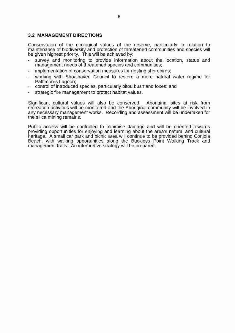
Narrawallee Creek Nature Reserve is located on the mid south coast of New SouthWales approximately 7km north of Ulladulla.
Narrawallee Creek Nature Reserve protects a variety of coastal environments,including coastal dunes, forest communities, Pattimores Lagoon and wetlandsadjacent to the Narrawallee Creek estuary. Five endangered ecological communitiesand two regionally significant vegetation communities, and three endangered and eightvulnerable fauna species, have been recorded in the reserve. Aboriginal middens andartefact scatters also occur in the reserve, as do silica deposits that were formedunder unusual geological circumstances. The reserve also provides low keyeducational and recreational opportunities for locals and visitors to the area.
The National Parks and Wildlife Act 1974 requires a plan of management to beprepared for each reserve. A plan of management is a legal document that outlineshow a reserve will be managed in the years ahead. A draft plan of management for Narrawallee Creek Nature Reserve was placed onpublic exhibition from 27 May until 29 August 2005. The exhibition of the draft planattracted 14 submissions that raised 8 issues. All submissions received were carefullyconsidered before adopting this plan. This plan provides for conservation of the ecological values of Narrawallee CreekNature Reserve. Aboriginal sites will be monitored and the Aboriginal community willbe involved in any necessary management works. Public access will be controlled tominimise damage and will be oriented towards providing opportunities for enjoying andlearning about the area’s natural and cultural heritage.
This plan of management establishes the scheme of operations for Narrawallee CreekNature Reserve. In accordance with section 73B of the National Parks and WildlifeAct 1974, this plan of management is hereby adopted.
Bob DebusMinister for the Environment
RESERVE PROFILE:
GAZETTAL DATE: Dedicated in 1986, with subsequent additions.
AREA: 878ha.
LOCATION: Mid South Coast, 7km north of Ulladulla. Shoalhaven Council LGA.
LANDFORM: Fairly flat, with beaches, sand dunes, low ridges, freshwater lagoonsand estuarine wetlands.
GEOLOGY: Primarily Permian sandstone and shale, with Quaternary dunes alongthe coastline and alluvial deposits adjacent to Narrawallee Inlet.
VALUES: Diverse vegetation types and habitats of forests, woodlands, heathlandsand wetlands. Areas of five endangered ecological communities(Coastal Saltmarsh, Swamp Sclerophyll Forest, Swamp Oak FloodplainForest, Littoral Rainforest and Bangalay Sand Forest) plus stands ofsignificant Coastal Red Gum Grassy Forest and Jervis Bay Lowland DryForest. Eleven species of threatened fauna recorded, includingbreeding sites for the little tern, hooded plover and pied oystercatcher.Several recorded Aboriginal sites and extensive remains from formersilica mining during the mid 20th century, including cuttings, mounds anda tramway.
VISITOR USE: Popular with locals and visitors. A walking track and vehicle trailsprovide attractive walking opportunities and there is a small picnic areaat the main entrance. Opportunities for swimming, surfing, cycling, birdwatching, scenery viewing and fishing.
ISSUES: The reserve is in good condition but some areas have been disturbed bysilica quarrying and grazing. There are occurrences of bitou bush andsea spurge along the coastline. The habitat values of PattimoresLagoon have been affected by downstream channel enlargement,altering it from mainly fresh to more saline and allowing introduction ofpollutants. Adjacent urban development is resulting in increasedisolation of the reserve and pressures on its natural values.
MANAGEMENT: The primary management emphasis will be conservation of significantvegetation communities and threatened species through weed control,fox control to protect nesting shorebirds, and appropriate fire regimes.Liaison will be undertaken with Shoalhaven City Council to seekrebuilding of the weir below Pattimores Lagoon. A conservation planwill be prepared for the silica mining features. Existing visitor facilitieswill be maintained and an interpretation plan will be prepared, providingfor information provision at the Conjola Beach car park and possibly thesilica mining operation.
CONTENTS
Page1. MANAGEMENT CONTEXT 1
1.1 Legislative and Policy Framework 11.2 Management Purposes and Principles 1
1.3 Regional Forest Agreements 1
2. THE PLANNING AREA 22.1 Location, Gazettal and Setting 22.2 Landscape Context 2
3. VALUES AND MANAGEMENT DIRECTIONS 43.1 Values of the Area 43.2 Management Directions 6
4. CONSERVATION OF NATURAL AND CULTURAL HERITAGE 8 4.1 Geology, Landform and Scenery 8
4.2 Native Vegetation 9 4.3 Native Animals 10
4.4 Aboriginal Heritage 124.5 Historic Heritage 13
5. RESERVE PROTECTION 155.1 Soil Erosion 155.2 Water Quality and Catchment Management 155.3 Introduced Species 165.4 Fire Management 19
6. VISITOR OPPORTUNITIES AND EDUCATION 23
7. OTHER USES 26
8. MONITORING AND RESEARCH 27
9. NPWS MANAGEMENT FACILITIES AND OPERATIONS 29
10. PLAN IMPLEMENTATION 30
REFERENCES 33
MAP 7

1
1. MANAGEMENT CONTEXT
1.1 LEGISLATIVE AND POLICY FRAMEWORK
The management of nature reserves in NSW is in the context of a legislative andpolicy framework, primarily the National Parks and Wildlife Act 1974 (NPW Act), theNPW Regulation, the Threatened Species Conservation Act 1995 (TSC Act) and thepolicies of the National Parks and Wildlife Service (NPWS). NPWS policies relate tonature conservation, cultural heritage conservation, recreation, commercial use,research and communication.
Other legislation, international agreements and charters may also apply tomanagement of the area. In particular, the Environmental Planning and AssessmentAct 1979 (EPA Act) requires the assessment and mitigation of the environmentalimpacts of any works proposed in this plan.
A plan of management is a statutory document under the NPW Act. The matters to beconsidered in the preparation of a plan of management are listed in Section 72AA ofthe Act. Once the Minister has adopted a plan, the plan must be carried out and nooperations may be undertaken within the area covered except in accordance with theplan. The plan will also apply to any future additions to the reserve. Shouldmanagement strategies or works be proposed in the future that are not consistent withthe plan, an amendment to the plan will be required.
1.2 MANAGEMENT PURPOSES AND PRINCIPLES
Nature reserves are reserved under the National Parks and Wildlife Act to protect andconserve areas containing outstanding, unique or representative ecosystems, species,communities or natural phenomena.
Under the Act, nature reserves are managed to:• conserve biodiversity, maintain ecosystem function, protect geological and
geomorphological features and natural phenomena;• conserve places, objects, features and landscapes of cultural value;• promote public appreciation, enjoyment and understanding of the reserve’s natural
and cultural values; and• provide for appropriate research and monitoring.
1.3 REGIONAL FOREST AGREEMENTS Narrawallee Creek Nature Reserve is covered by the Southern Regional ForestAgreement. Regional Forest Agreements (RFA) are one of the principal means ofimplementing the National Forest Policy Statement of 1992. Under this StatementCommonwealth, State and Territory governments agreed to work towards a sharedvision for Australia’s forests. Joint comprehensive regional assessments (CRA) wereundertaken of the natural, cultural, economic and social values of forests and theseassessments formed the basis for negotiation of RFAs providing for, amongst otherthings, ecologically sustainable forest management.
2
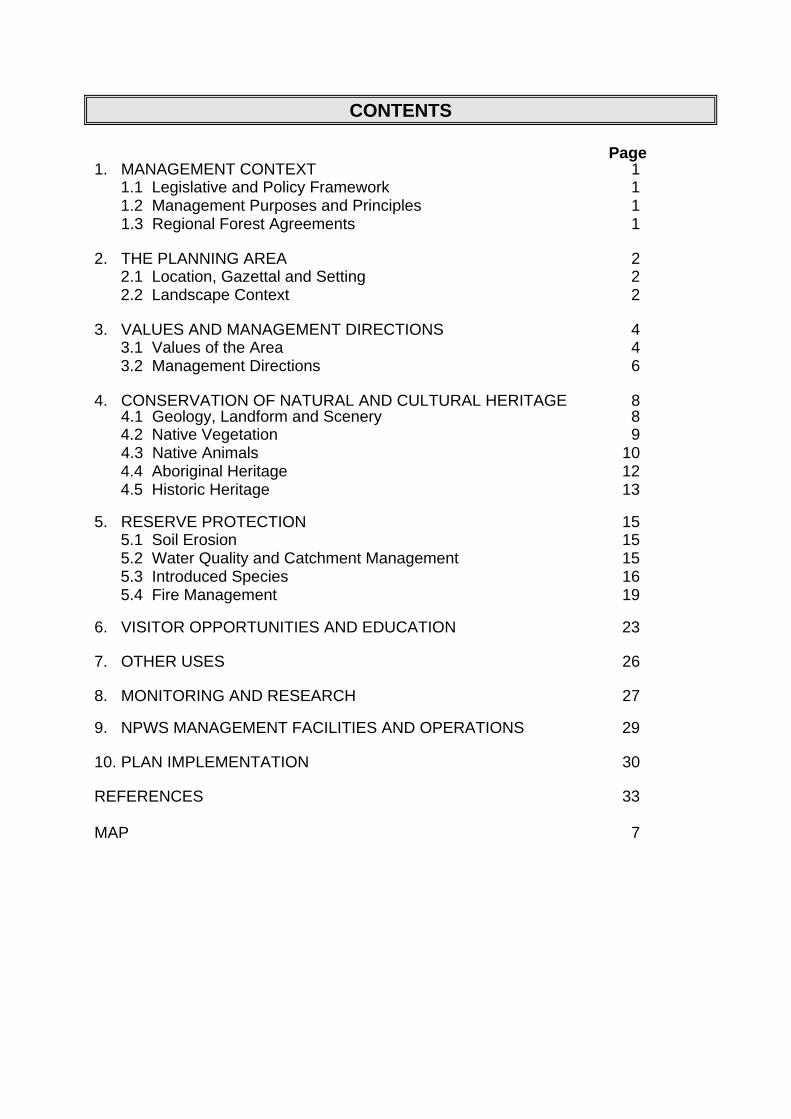
2. THE PLANNING AREA 2.1 LOCATION, GAZETTAL AND SETTING
Narrawallee Creek Nature Reserve is located on the mid south coast of New SouthWales approximately 7km north of Ulladulla (see Map). It was dedicated in 1986 andsubsequent land additions, including areas of Crown land added in 2001 as part of theSouthern Regional Forest Agreement, have brought the area to about 878 hectares.
The reserve is located between the townships of Lake Conjola and Narrawallee, withNarrawallee Creek forming the southern boundary. Grazing land adjoins the westernboundary of the reserve and Conjola National Park is located adjacent to part of thenorthern boundary.
2.2 LANDSCAPE CONTEXT The reserve protects a variety of coastal environments, notably coastal dunes, forestcommunities, Pattimores Lagoon and wetlands adjacent to the Narrawallee Creekestuary. Natural and cultural heritage are strongly inter-related and together form the landscapeof an area. The geology, landform, climate and plant and animal communities of thereserve, plus its location, have determined how it has been used by humans.Aboriginal people have utilised the resources of the area for at least 20,000 years,especially the estuary and coastline, as is indicated by archaeological sites such asmiddens. Non-indigenous people have used the area for quarrying, logging, grazing
#
##
##
#
#
Berrara
Bendalong
Cudmirrah
Cunjurong
Ulladulla
Lake Conjola
Sussex Inlet
Conjola National Park
Meroo National Park
Yatteyattah Nature Reserve
Morton National Park
NARRAWALLEE CREEK NATURE RESERVE
# Narrrawallee

3
and recreation use since the 1800s. These uses have affected the vegetationstructure, changed the landform in the vicinity of the silica mining and formed theexisting network of roads and trails. Both Aboriginal and non-Aboriginal people place cultural values on natural areas,including aesthetic, social, spiritual, recreational and other values. Cultural valuesmay be attached to the landscape as a whole or to individual components, for exampleto plant and animal species used by Aboriginal people. Cultural values may consist ofboth physical remains and non-physical manifestations such as knowledge, storiesand memories. This plan of management aims to conserve both natural and culturalvalues. For reasons of clarity and document usefulness natural and cultural heritage,non-human threats and on-going use are dealt with individually, but their inter-relationships are recognised.
4
3. VALUES AND MANAGEMENT DIRECTIONS 3.1 VALUES OF THE AREA
The reserve is of regional significance for its biological, landscape and cultural values.It is included on the register of the National Estate due to the diversity of its habitats,including mangroves, dune forest, salt and brackish lagoons in good condition, and forits silica deposits formed under unusual geological circumstances (see section 4.1).
Geology and Landform
The reserve contains a variety of landforms and environments including beaches,sand dunes, forested lowlands and ridges, lagoons, estuarine wetlands andforeshores. It includes approximately four kilometres of coastline reserved to highwater mark.
The reserve protects most of the catchment and bed of Pattimores Lagoon, part of thecatchment and foreshores of Narrawallee Creek and part of the catchment of ConjolaLake. The lower reaches of the Narrawallee Creek estuarine system remain in a nearnatural state and the geomorphological processes and wildlife supported by thissystem are of high scientific and conservation value.
Pattimores Lagoon, the shores of Narrawallee Creek and other low lying areas in thereserve are classified as coastal wetlands under State Environmental Planning Policy(SEPP) 14.
A well-preserved stratigraphy on tertiary silica deposits has been exposed by silicaextraction over much of the 20th century at the northern end of the reserve. This is animportant scientific and educational feature.
Biodiversity
The reserve protects a high diversity of vegetation types and habitats in a relativelysmall area, including forests, woodlands, heathlands, freshwater and estuarinewetlands. It also helps to protect the adjacent beach and rocky coastline habitats andaquatic habitat for fish, invertebrates and plants in the adjacent Narrawallee estuary.The estuarine communities are particularly significant as extensive vegetatedestuarine environments are rare on the mid south coast of NSW.
The endangered ecological communities Coastal Saltmarsh, Swamp SclerophyllForest (dominated by swamp mahogany Eucalyptus robusta), Swamp Oak FloodplainForest (dominated by Casuarina glauca), Bangalay Sand Forest and Littoral Rainforestare found in the reserve. Swamp mahogany is an important food source for severalthreatened animal species including the swift parrot (Lathamus discolor), regenthoneyeater (Xanthomyza phrygia), yellow-bellied glider (Petaurus australis) and grey-headed flying-fox (Pteropus poliocephalus).
Also in the reserve are the restricted Coastal Red Gum Grassy Forest and theregionally significant Jervis Bay Lowland Dry Forest (see section 4.2). Forest red gum(Eucalyptus tereticornis) has been cleared from much of its former area of occurrenceand is poorly represented in the reserve system.
The vulnerable plant species Cryptostylis hunteriana has been recorded to the northand south of the reserve and may occur within it. The ROTAP (national register ofrare or threatened Australian plants) listed yellow bush pea (Pultenaea villifera) has
5
been recorded just outside the reserve and may occur within it. Grey gum (Eucalyptuspunctata) reaches its southern limit within the reserve and the fern Blechnum indicumis very close to its southern limit (Ngh environmental 2004).
Although there has been a history of logging, quarrying, wildfire and some grazing,significant areas of old growth forest have been identified particularly at the southernend of the reserve. Old growth forest has high aesthetic and habitat value, particularlyfor arboreal mammals and birds dependent upon tree hollows.
The number of fauna species recorded in the reserve is high for a small area and isprobably due to the diverse habitats in close proximity and their good condition.Pattimores Lagoon is a significant breeding and feeding area for waterbirds and is alsolikely to provide valuable coastal drought refuge for waterbirds.
The reserve is significant for threatened fauna species. Three endangered and eightvulnerable fauna species (listed in Schedule 1 and Schedule 2 of the ThreatenedSpecies Conservation Act) have been recorded in the reserve. Endangered speciesrecorded are the little tern (Sterna albifrons), hooded plover (Thinornis rubricollis) andgreen and golden bell frog (Litoria aurea). Vulnerable fauna species recorded are theosprey (Pandion haliaetus), glossy black-cockatoo (Calyptorhynchus lathami),powerful owl (Ninox strenua), gang-gang cockatoo (Callocephalon fimbriatum), sootyoystercatcher (Haematopus fuliginosus), pied oystercatcher (Haematopus longirostris),grey-headed flying-fox (Pteropus poliocephalus) and eastern bent-wing bat(Miniopterus schreibersii oceanensis). The little tern, hooded plover and piedoystercatcher breed from time to time at Narrawallee Inlet and on Crown land at theentrance to Conjola Lake.
Cultural heritage
Aboriginal middens and artefact scatters occur in the nature reserve. It is likely thatthe coastline and estuaries were formerly important resource sites.
Evidence of former silica mining exists in the reserve, including cuttings, mounds anda tramway used to transport the silica (see 4.5). The silica industry was formerly ofeconomic and social importance to the region, particularly between the First andSecond World Wars.
Scenery
The coastline of the nature reserve is extremely attractive, with a variety of featuressuch as sandy beaches, rock outcrops, wetlands and diverse vegetation communities.The reserve has a sense of peace and isolation because of the adjacent waterwaysand minimal views of developed areas.
The reserve enhances the scenic amenity of the district by providing a naturalbackdrop to the important waterway of Narrawallee Inlet.
Educational, tourism and recreational values
The reserve provides low key educational and recreational opportunities (beachactivities and bushwalking) for locals and visitors to the area.
6
3.2 MANAGEMENT DIRECTIONS
Conservation of the ecological values of the reserve, particularly in relation tomaintenance of biodiversity and protection of threatened communities and species willbe given highest priority. This will be achieved by:- survey and monitoring to provide information about the location, status and
management needs of threatened species and communities;- implementation of conservation measures for nesting shorebirds;- working with Shoalhaven Council to restore a more natural water regime for
Pattimores Lagoon;- control of introduced species, particularly bitou bush and foxes; and- strategic fire management to protect habitat values.
Significant cultural values will also be conserved. Aboriginal sites at risk fromrecreation activities will be monitored and the Aboriginal community will be involved inany necessary management works. Recording and assessment will be undertaken forthe silica mining remains.
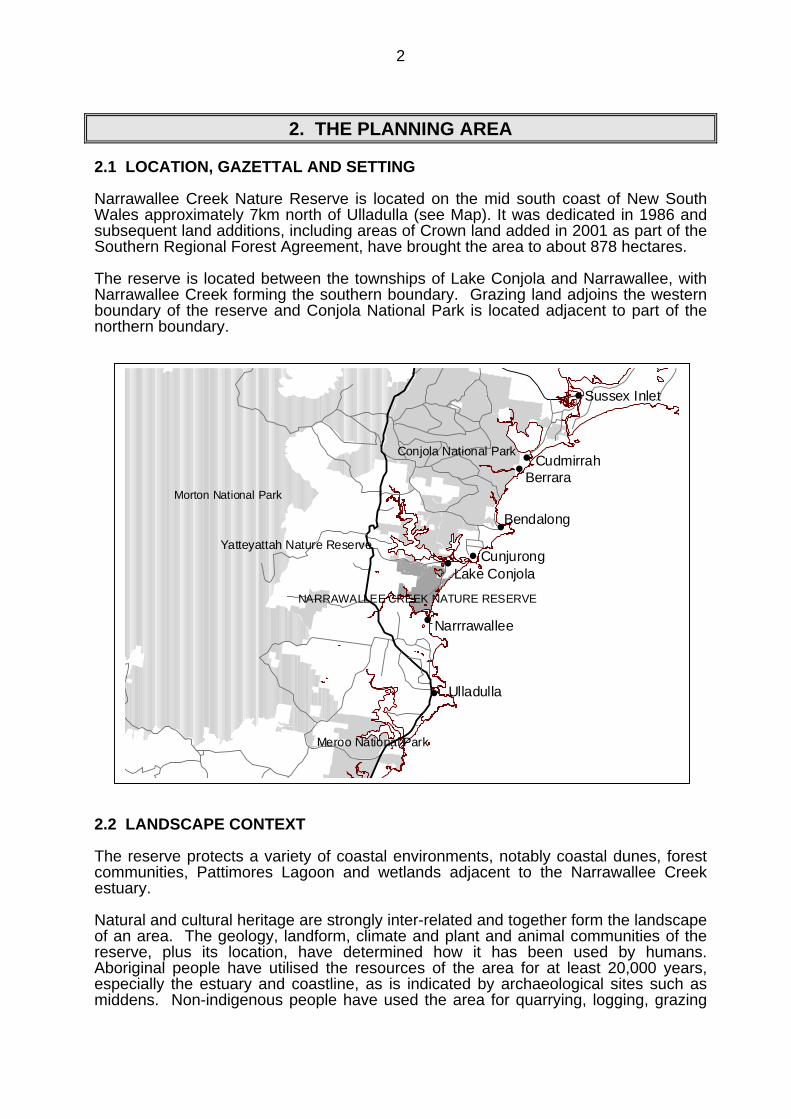
Public access will be controlled to minimise damage and will be oriented towardsproviding opportunities for enjoying and learning about the area’s natural and culturalheritage. A small car park and picnic area will continue to be provided behind ConjolaBeach, with walking opportunities along the Buckleys Point Walking Track andmanagement trails. An interpretive strategy will be prepared.

Narrawallee Creek Nature Reserve
∀
&
Silic
a R
i dge TrailBuckleys Po int Trail
I nle
t Tra
ck
Man
grov
e Tr
ack
N orther n Link Tr ail
Conjola Beach Picnic Area
Narrawallee Creek Rd Car Park
Buckleys Point
Narrawallee Inlet
Pattimores Lagoon
Conjola Lake
Lake Conjola
Narrawallee
Narrawall
ee
Cre
ek
Road
Conjola National Park
Buck
leys
Bea
c h
Conjola
Beach
0 250 500 750 1000 MetresN
EW
S
Public access road
Management trail
Walking track
Narrawallee Creek NR
NPWS land
Sepp 14 wetlands

8
4. CONSERVATION OF NATURAL AND CULTURAL HERITAGE
4.1. GEOLOGY, LANDFORM AND SCENERY
The underlying geology of the reserve is mainly composed of the Permian ConjolaFormation, a series of sandstone and shale units. There are Quaternary sand dunesalong the coastline and alluvial deposits adjacent to Narrawallee Inlet.
The sand deposits are extensive, forming dunes along the coastline and flat depositsat the southern end of the reserve. Those in the northern part of the reserve arehigher and appear to be older, possibly aeolian and fluvial deposits.
Tertiary silica deposits occur south of Pattimores Lagoon on a low ridge. Thesedeposits were probably formed through hydrothermal agencies from basalt overflows.The silica deposits consist of approximately 4m of dense locally banded white to pinksilica. Two small residuals of basalt overlie the silica.
The reserve is fairly flat but landforms include beaches, sand dunes, low ridges,several lagoons and estuarine wetlands. The areas adjacent to Narrawallee Inlet arelow lying and poorly drained.
The largest lagoon is Pattimores Lagoon. Its habitat values have been affected bydownstream channel enlargement as part of an adjacent canal estate development,altering it from mainly fresh to more saline, possibly lowering water levels and allowingintroduction of pollutants (see section 5.2). There are smaller lagoons north ofBuckleys Point and at the southern end of the reserve.
Silica quarrying (section 4.5) has resulted in a disturbed area of quarry walls, largemounds, pits and cuttings over a large area north and south of the Silica Ridge Trail.This has significantly altered the original landscape. The quarried areas are stableand have revegetated apart from the floor of a more recently quarried area near thecentre of the silica ridge.
The reserve’s coastline, estuaries and forests are very attractive. Protection of theforeshore vegetation is important, both for landform stability and scenic value.
Sand extraction and urban development, including the construction of a wastewatertreatment plant, are taking place to the north and west of the reserve, with impacts onthe area’s scenic values, sense of isolation and other values.
Desired Outcomes
• Significant geological and geomorphological features are protected, particularly thesand dunes and wetlands associated with Narrawallee Inlet and PattimoresLagoon.
• Natural processes are maintained or, in the case of Pattimores Lagoon, restored(section 5.2).
• The scenic values of the reserve, and in particular the relatively undisturbedcoastline and foreshores, are maintained.
9
Strategies
• Design and undertake all management actions in a manner that avoids damage tothe natural landscape, particularly the coastal dune system, estuaries and lagoons,and their associated vegetation.
• Leave the former silica quarries, mounds and cuttings as at present and do notreshape.
• Promote revegetation of the floor of the recently operated quarry by ripping, brushmatting or planting with local species.
• Liaise with neighbours and authorities where needed to minimise the impact ofadjacent land uses on the scenic values of the reserve.
4.2 NATIVE VEGETATION
The reserve has a variety of vegetation types as described below.
Herblands on the foredunes include Spinifex sericeus and Lomandra longifolia, andare backed by low closed scrub with coast wattle (Acacia longifolia var. sophorae),Correa alba and Leucopogon parviflorus on the hind-dunes. A small area of heathdominated by Westringia fruticosa occurs at Buckleys Point.
Further inland, coast banksia (Banksia integrifolia) merges into a bangalay (Eucalyptusbotryoides), old man banksia (Banksia serrata) and burrawang (Macrozamiacommunis) association on the parallel dune system. As stated in section 3.1, thiscommunity is listed as an endangered community (Bangalay Sand Forest). Outsidereserves it is threatened by clearing, frequent burning and weed invasion.
Well drained areas in the central and western parts of the reserve are covered by tallopen forests dominated by blackbutt (E. pilularis), red bloodwood (Corymbiagummifera) and turpentine (Syncarpia glomulifera). These forests have a diverseunderstorey of flowering shrubs. Large blackbutts are also found on the stabilisedareas of flat sand in the southern part of the reserve in association with old manbanksia.
The edges of Pattimores Lagoon and other small swampy areas are dominated byswamp paperbark (Melaleuca ericifolia) in a low closed scrub with Baumea juncea, saltrush (Juncus kraussii) and common reed (Phragmites australis).
The shores of Narrawallee Creek support saltmarsh, mangroves (Avicennia marina)and extensive areas of swamp oak forest (Casuarina glauca). These communities areimportant for foreshore protection and the mangroves have a fish nursery role. Thereis also an area of swamp oak at Buckleys Point. As stated in section 3.1, CoastalSaltmarsh and Swamp Oak Floodplain Forest are listed as endangered ecologicalcommunities under the Threatened Species Conservation Act.
The endangered ecological community Swamp Sclerophyll Forest occurs as a largearea of low open forest on low-lying land in the southern part of the reserve and insmaller patches in the north and west. It is dominated by swamp mahogany (E.robusta) and has a dense understorey of Melaleuca species. This community isvulnerable to weed invasion, inappropriate fire regimes and changes to hydrologicalconditions but there are no current threats to the stands in the reserve.
The restricted Coastal Red Gum Grassy Forest community occurs in a small areasouth of Pattimores Lagoon, adjacent to the silica quarry area. It is a medium to tall
10
forest dominated by forest red gum (E. tereticornis) with white stringybark (E.globoidea) and rough barked apple (Angophora floribunda). The ground cover isThemeda australis and Danthonia longifolia with scattered shrubs and forbs. Thecommunity occurs on relatively fertile soils and is therefore vulnerable to weedinvasion (see section 5.3). It appears to have been partially disturbed by silicaquarrying operations and possibly has been grazed in the past. An appropriate fireregime is necessary for maintenance of the forest structure (see section 5.4).
The regionally significant Jervis Bay Lowlands Dry Forest community occurs in thewestern parts of the reserve. It is a medium height forest dominated by grey gum (E.punctata), along with other tree species such as red bloodwood, thin-leavedstringybark (E. eugenioides) and black she-oak (Allocasuarina littoralis). There are nocurrent threats to the stands in the reserve.
There is a small area of the endangered ecological community Littoral Rainforest atBuckleys Point.
As stated in section 3.1 the vulnerable Cryptostylis hunteriana and ROTAP speciesPultenaea villifera may occur in the reserve. Survey is needed to check for theirpresence. Pultenaea villifera, if found, will require protection from too frequent fire.
The vegetation communities in the reserve are in relatively good condition. Parts ofthe reserve have been subject to selective logging in the past but this has not had aserious detrimental impact on floristic composition or structure. As stated above, silicaquarrying and possibly grazing have disturbed the Coastal Red Gum Grassy Forestand other areas in the north eastern part of the reserve. Areas along the westernboundary have also been disturbed by grazing from adjacent properties (section 5.3).
Vegetation plots have been established in a number of locations and these may beused for monitoring programs if needed.
Desired Outcomes
• The full range of native plant species found in the reserve is conserved.
• Vegetation structural diversity and habitat values are conserved, and are restoredwhere subject to past disturbance.
• The endangered and restricted vegetation communities are conserved.
• The habitat and populations of all threatened and biogeographically significantspecies are protected and maintained.
Strategies
• Monitor the condition of the Swamp Sclerophyll Forest, Swamp Oak FloodplainForest, Coastal Saltmarsh, Bangalay Sand Forest and Littoral Rainforest and takeany steps to address threats if needed.
• Survey to determine whether Cryptostylis hunteriana and Pultenaea villifera arepresent within the reserve.
4.3 NATIVE ANIMALS
The native fauna of the reserve is diverse and the reserve is an important refuge forlocal fauna populations. A total of 113 bird species and 11 mammals have beenrecorded so far but little is known about the reserve’s reptile or amphibian fauna.
11
Bird species recorded comprise water birds, seabirds, raptors and a large variety ofbirds dependent on open forest/heathland vegetation. As stated in section 4.1, thebird breeding and feeding value of Pattimores Lagoon has been adversely affected byalteration of the lagoon from largely fresh to tidal following adjacent canaldevelopment.
Mammals recorded include arboreal mammals, macropods and bats. There may alsobe populations of small mammal species such as the dusky antechinus (Antechinusswainsonii), long-nosed bandicoot (Perameles nasuta), bush rat (Rattus fuscipes) andcommon dunnart (Sminthopsis murina) which have been recorded to the north inConjola National Park.
The nature reserve is relatively small and isolated, being mostly surrounded by ruralgrazing land and urban development. The viability of habitats in the reserve is to alarge extent dependent on the continued existence and sympathetic management ofremaining adjacent natural areas. Progressive loss of naturally vegetated areas andfurther isolation could lead to species loss within the reserve and could occur as partof urban and semi-rural expansion taking place to the north and west at Lake Conjolaand to the south at Narrawallee.
Narrawallee Inlet potentially contains the threatened Australian grayling (Prototroctesmaraena) and black cod (Epinephelus daemiliee). It may also have populations ofprotected Syngnathiformes species (seahorses,etc). Management of fish in NSW isthe responsibility of the Department of Primary Industries (Fisheries) but where theirhabitats are located in or adjacent to reserves the Service aims to protect thosehabitats. The most important requirements for protection of fish habitat in the area areprotection of foreshore vegetation and prevention of siltation and turbidity by runofffrom roads and trails. Minimising the number of trails within the reserve will also assistprotection of water quality.
Threatened species
Threatened species recorded in the reserve are listed in section 3.1. The reserve hasalso been modelled as containing significant habitat for several threatened species notyet recorded including the long-nosed potoroo (Potorous tridactylus), spotted-tail quoll(Dasyurus maculatus), smoky mouse (Pseudomys fumeus), masked owl (Tytonovaehollandiae), sooty owl (Tyto tenebricosa), swift parrot and greater broad-nosedbat (Scoteanax rueppellii). Future survey may confirm the presence of these species.
The Swamp Sclerophyll Forest provides a relatively large area of suitable habitat forthe vulnerable swift parrot (Lathamus discolor) and the endangered regent honeyeater(Xanthomyza phrygia). Survey is needed to check for the presence of these specieswhen the swamp mahogany is in flower.
The management needs of threatened species will be established as part of anyrecovery plans prepared under the Threatened Species Conservation Act. Specificmanagement actions may be undertaken to assist the survival of threatened speciessuch as temporary fencing of shorebird nesting areas in conjunction with publiceducation and pest control programs.
Desired Outcomes
• Knowledge of native fauna in the reserve is improved.
• The full range of native animal species in the reserve is conserved.
12
• The habitat and populations of all threatened species are protected andmaintained.
• The impacts on the reserve of adjacent development are minimised andneighbours and land use authorities support conservation of remaining areas ofnative vegetation near the reserve.
Strategies
• Conserve the diversity and high quality of habitats for native animals occurring inthe reserve through maintenance of natural processes, minimisation of humanimpacts and specific conservation programs where necessary.
• Undertake specific management programs for conservation of threatened species,particularly the little tern, hooded plover and pied oystercatcher. Monitor shorebirdnesting, undertake pest management and erect temporary protective fencing andsigns as needed.
• Implement relevant measures included in any recovery plans prepared forthreatened species occurring in the reserve.
• Undertake fauna surveys targeting threatened species such as the green andgolden bell frog, southern-brown bandicoot, swift parrot and regent honeyeater.
• Carry out periodic surveys of threatened species to monitor their status andresponse to management programs.
• Liaise with neighbours and land use authorities to encourage retention of areas ofnative vegetation close to the reserve.
4.4 ABORIGINAL HERITAGE
Aboriginal people have utilised the resources of the South Coast for at least 20,000years and this long association continues. The nature reserve is situated within thelands of the Wanda Wandian speaking people and the Budawang/Murramarang tribesof the Dhurga language group. Today, the nature reserve is in the area of the JerrinjaLocal Aboriginal Land Council and the Shoalhaven Elders Group.
It is recognised that the landscape, and the plants, animals and physical featureswithin the landscape are all an integral part of Aboriginal cultural heritage. It is likelythat the reserve was an important food gathering area because of the proximity of theNarrawallee Creek estuary, lagoons, Conjola Lake and the ocean.
The reserve area has not been formally surveyed for Aboriginal sites and places butsome middens and artefact scatters have been found. It is likely that other sites exist,possibly including stone artefact quarries (if not destroyed by the extensive silicaquarrying in more recent historic times) and burials as such sites have been foundnearby. Archaeological sites are important to Aboriginal communities as they are atestament to their culture’s great antiquity. Aboriginal sites and places are alsoimportant to non-Aboriginal people as they provide information about past ways of life.
The known Aboriginal sites are located on the coastline and the shores of NarrawalleeCreek and Pattimores Lagoon. As such, they are potentially at risk from naturalerosion processes or human use.
While the Service has legal responsibility for the protection of Aboriginal sites withinreserves it acknowledges the right of Aboriginal people to make decisions about their
13
own heritage. It is therefore policy that Aboriginal communities be consulted aboutdecisions regarding the management of Aboriginal sites and related issues and howthe Aboriginal culture and history of an area controlled by the Service will be promotedand presented.
Desired Outcomes
• Aboriginal sites and places are protected from damage by visitor and managementactivities.
• Aboriginal people are involved in management of Aboriginal cultural values in thereserve.
Strategies
• Consult and actively involve the Jerrinja Local Aboriginal Land Council and otherrelevant Aboriginal community organisations and individuals in all aspects ofmanagement of Aboriginal sites and places in the reserve.
• Protect Aboriginal sites and places from disturbance or damage by humanactivities, in conjunction with the Aboriginal community.
• Monitor the condition of Aboriginal sites at risk and undertake protective works ifneeded to prevent damage by recreational activities.
• Undertake a predictive assessment for Aboriginal sites and survey areas wheresites may be at risk. Precede all works with the potential to impact on Aboriginalsites by an archaeological assessment.
• Do not publicise the location of Aboriginal sites except where:- the agreement of the Jerrinja Local Aboriginal Land Council and other relevant
Aboriginal community members has been obtained;- a conservation study has been prepared and any management works
necessary to protect the site from damage have been implemented; and- the site is interpreted in consultation with local Aboriginal people to promote
public knowledge and appreciation of Aboriginal culture.
4.5 HISTORIC HERITAGE
Prior to dedication, the reserve was a combination of vacant Crown land and Crownlease. There was little clearing or development apart from some logging, quarryingand grazing.
Selective logging of hardwoods such as blackbutt and turpentine was carried out in thearea prior to reservation, probably during the early 1900s. A number of large stumpsremain, showing notches where springboards were placed by the axemen. Loggingactivities modified the structure of the forests and created several vehicle trails.
Substantial deposits of nearly pure silica were mined in the Ulladulla and Bendalongarea from as early as 1918 until 1975. At first all the silica mined in the district had tobe transported by horse and dray to wharves at Ulladulla and Red Head nearBendalong but timber tramlines were later built and horses pulled iron skips along thelines (McAndrew, 1995).
Extraction began from extensive silica deposits south of Pattimore’s Lagoon, nowwithin the nature reserve, in 1926, commencing at the eastern end of the silica ridge.

14
The silica was broken up by explosives and by hand using spalling hammers. Atramline transported silica spalls from the lease area via a bridge across NarrawalleeInlet to Bannisters Head at Mollymook. The tramline consisted of steel rails on timbersleepers, and followed a relatively straight line from the lease to the Inlet, parallel tothe coast. In places the line formation was built up to keep it level. Timber skips werehauled by a locomotive. The silica rock was crushed at Bannisters Head and shippedto Port Kembla or Newcastle for production of high quality refractory bricks for use inthe steel furnaces (McAndrew, 1995).
The tramline across Narrawallee Inlet was in use until the start of the Second WorldWar but in 1947, after a lull in extraction, the silica began to be transported by road toa crusher at Yatteyattah, and later directly to Port Kembla. The bulk of the tramlinerails were taken up in 1943 and in 1944 the bridge was dismantled (McAndrew, 1995).Most of the bridge posts have rotted but a few remain on the northern side of the Inlet.The raised tramline route is still visible in the reserve and sleepers can be found buriedbeneath soil and vegetation.
Silica extraction largely ceased at the Pattimores Lease in 1975 although extraction forroad construction occurred later from an area to the west of the main quarry, probablyduring the 1980s and possibly later. As stated in section 4.1, quarries, cuttings andmounds remain from the operations. A metal skip or boiler is located near the quarriedarea. The significance of this relic is presently unknown. While rusting, it appears tobe in reasonable condition.
The tramline formation is stable at present. Fire management considerations for thetramline have been included in the Fire Management Strategy prepared for the reserve(see section 5.4) and a proposed conservation analysis will consider whether anyother protective measures are needed.
A small corrugated iron shed is located near the silica quarry. It is thought that thiswas of recent construction and associated with grazing activity in the former leasearea but this has not been confirmed. A water tank and length of barbed wire fence arelocated nearby. These features are not considered likely to have historic significancebut have not been formally assessed.
Part of the silica quarry area was used informally for rubbish dumping during the1980s until a recycling and waste depot was provided for Lake Conjola village. Thereis no visible material remaining from this use.
Parts of the western and northern areas of the reserve were formerly used for reliefgrazing by adjacent property owners in times of flooding and drought.
Desired Outcomes
• Historic features are appropriately conserved and managed.
Strategies
• Manage historic places in accordance with the Burra Charter.
• Record and assess features remaining from silica mining activities, including themetal skip or boiler. Prepare a conservation plan and undertake conservationworks if required.
• Determine the former use of the corrugated iron shed, fence and water tank andassess their significance. Develop a management strategy if found to besignificant or record and remove if not significant.

15
5. RESERVE PROTECTION
5.1 SOIL EROSION
Soils in the reserve consist primarily of shallow sandy loams and sands over finesands and sandy clay subsoils. They are erosion prone and become very unstablewhen the topsoil is removed. In well-drained flat areas they form good road surfacesbut on slopes or wet areas they break down. Parts of the reserve along NarrawalleeCreek are subject to inundation, affecting the Mangrove Track management trail.
There are minor dune blowouts along the beach front, primarily as a result of naturalprocesses. Blowouts are of most concern in areas subject to human impact. An areawhere erosion was being accelerated by sand sliding has been fenced and twopedestrian access points over the dunes (at the northern end of the reserve and at theConjola Beach car park) have been defined with fencing and board and chainwalkways.
The foreshores of Narrawallee Inlet appear to be relatively stable but are potentially atrisk of erosion from boating activity or floods, particularly from boats landing on thereserve shore. It will be important to maintain good vegetation cover on theforeshores.
Desired Outcomes
• Human induced soil erosion in the reserve is minimised.
• Significant natural and cultural values are not threatened by erosion.
Strategies
• Design and undertake all works in a manner that minimises soil erosion.
• Take appropriate erosion control measures where erosion has been accelerated byhuman activity or is threatening significant habitats or other values.
• Monitor areas of dune blowout and, if needed, take action to prevent furthererosion.
• Monitor foreshore areas along Narrawallee Inlet and take action if needed toensure maintenance of vegetation cover. Discourage recreational use in areassubject to erosion.
• Avoid driving on management trails when they are affected by inundation.
5.2 WATER QUALITY AND CATCHMENT MANAGEMENT
The reserve plays a major role in protection of Narrawallee Inlet, Pattimores Lagoonand several small wetland areas.
Narrawallee Inlet is in relatively good condition with a combination of forest andgrazing land in its catchment. The Healthy Rivers Commission Independent Inquiryinto Coastal Lakes (Healthy Rivers Commission, 2002) identified Narrawallee Inlet aswarranting significant protection.
16
A natural resource and floodplain management committee has been established byShoalhaven City Council for Narrawallee Inlet to oversee implementation of the naturalresource management plans prepared for the Inlet. The Service is a member of thiscommittee.
Pattimores Lagoon was originally a largely freshwater wetland, receiving a limited tidalexchange only during particularly high tides. Canal development on the creek thatleads from the lagoon outside the reserve has altered the natural flow regime andwater quality in the lagoon, letting in salt water and pollutants and increasing the rateof sedimentation (Findlay, 1988). This has affected vegetation distribution andwaterbird use, with decline in bird numbers, death of swamp oak and establishment ofmangroves. Freshwater wetlands are rare on the South Coast whereas tidal andbrackish estuaries are relatively common. A weir built to partially deal with the salineincursions has been in disrepair for some years and needs to be reconstructed. Thisis supported by the Lake Conjola Estuary Management Plan. The Department ofPrimary Industries supports restoration of the lagoon but would need to be consultedin relation to any impacts of the weir re-building on fish passage.
Rubbish dumping occurs in the reserve along Narrawallee Creek Road, particularlywhen the adjacent recycling and waste depot is closed, with consequent visualimpacts and the potential for pollution and promotion of feral animal populations.
A wastewater treatment plant is planned to be constructed adjacent to the northeastern boundary of the reserve utilising dune exfiltration for management ofreclaimed water. Monitoring of water quality in the reserve, particularly at PattimoresLagoon, would be needed to check for any impacts.
Desired Outcomes
• The reserve’s catchment values and the water quality and health of streams andestuaries are maintained.
Strategies
• Design and undertake all works in a manner that minimises water pollution.
• Liaise with local government and other authorities to maintain and improve thewater quality of the reserve’s catchments and wetlands.
• Liaise with Council to seek rebuilding of the weir on the canal development nearPattimores Lagoon, with the aim of returning the lagoon to near natural levels ofsalinity compatible with restoring natural aquatic communities. Liaise as neededwith the Department of Primary Industries, Department of Natural Resources andother relevant agencies. Undertake an education campaign with neighbours toraise understanding of the lagoon’s values and support for the rebuilding of theweir.
• Undertake research as needed to record the current condition of PattimoresLagoon and monitor changes following rebuilding of the weir.
• Work with Council to explore strategies for minimising rubbish dumping.
• Seek water quality monitoring by Shoalhaven Council at Pattimores Lagoon andother locations within the reserve that may be affected by the construction of thewastewater treatment plant and dune exfiltration system at Lake Conjola. Themonitoring program should include an assessment of water quality prior tooperation of the plant and consideration of inputs from local caravan parks.
17
5.3 INTRODUCED SPECIES
An introduced species is defined in this plan as any plant or animal species notindigenous to the area. Introduced species within the reserve and on adjoining landare of concern because they have the potential to have detrimental effects onecological values and can spread to and from neighbouring land.
Weeds
The occurrence of introduced plant species in the reserve is low. Most of the weedsoccur on the sand dunes and on areas that have been disturbed in the past such asthe former silica mining area and Buckleys Point. There are occurrences of Cape ivy(Delairea odorata), moth vine (Araujia hortorum), coral tree (Erythrina X sykesii),lantana (Lantana camara), arum lily (Zantedeschia aethiopica), bridal creeper(Myrsiphyllum asparagoides), mist flower (Ageratina riparia), smooth senna (Sennafloribunda) and other weeds in the reserve. Suppression of weeds has occurred in thereserve over many years and remnant weeds are controlled. There are, however,areas of exotic grasses remaining at a number of locations and occurrences of otherweeds in disturbed areas.
As previously stated, the significant Red Gum Grassy Forest community is vulnerableto weed invasion. A number of minor weeds have been observed but no formal surveyhas been undertaken to ascertain the extent of weeds.
The Noxious Weeds Act 1993 places an obligation upon public authorities to controlnoxious weeds on land that they occupy to the extent necessary to prevent suchweeds spreading to adjoining lands. The only declared noxious weed that is known tooccur in the reserve is bitou bush (Chrysanthemoides monilifera ssp. rotundata).
Bitou bush occurs in the dune system behind Conjola Beach. Infestations have beenmapped and occur in medium to low densities. The worst infestations are in thenorthern section of the reserve. Boneseed (Chrysanthemoides monilifera ssp.monilifera), a close relative to bitou bush, occurs at Buckleys Point and at low levelson the more clay based soils along Narrawallee Inlet. This could potentially threatenthe endangered Swamp Sclerophyll Forest and needs to be monitored (DEC, 2004)
Bitou bush and boneseed are primarily spread from area to area by foxes and birds.Effective and on-going control is essential because of the high ability of these speciesto spread rapidly into undisturbed bushland and to smother native species. Thereforeit is essential to have an integrated approach to control. A bitou bush working groupconsisting of representatives from NPWS, Dept Lands, Council, Healthy Cities and thelocal community has operated for a number of years in the Lake Conjola/Mollymookarea. This committee oversees a control program that is funded by Coastcare grantsand employs a part time coordinator to organise volunteer programs.
Bitou bush control programs in the nature reserve over the past ten years haveinvolved ground and aerial spraying programs and intensive hand pulling by Servicestaff and volunteers. These efforts have dramatically reduced the occurrence of bitoubush in the reserve.
Spiny rush (Juncus acutis) has recently been observed at Pattimores Lagoon. Thishas the potential to affect native species and habitat values.
There are small occurrences of sea spurge (Euphorbia paralias) on Conjola andBuckleys Beaches. This species could threaten seabird breeding success in thereserve. It is an emerging weed in the region, seeds prolifically and can be re-introduced during high sea levels.

18
A small area of Caulerpa taxifolia is found adjacent to the reserve in Narrawallee Inlet.Caulerpa is an invasive marine species that is easily spread by boating and fishingactivities as well as wave action. It can rapidly displace native aquatic vegetation suchas seagrass and therefore potentially affect the habitat values of estuarine areas.
Introduced Animals
Foxes, rabbits, cats and occasionally wild dogs are present in the reserve. Rabbitsare found in low numbers in the dune systems and on the edge of Lake Conjolavillage. Monitoring is undertaken to check that numbers remain low.
Foxes are the major threat to ground dwelling native animals in the reserve, includingbreeding success of threatened shorebirds such as the little tern and piedoystercatcher, and are known to spread weeds such as bitou bush. Predation by theRed Fox is a Key Threatening Process under the TSC Act for critical weight rangemammals and ground nesting birds. A 1998 survey (Olsen & Latimer) found low tomoderate fox activity in the reserve. The survey helped to identify areas that requirecontrol programs. Generally fox and wild dog control programs are undertaken at thesame time and several have been carried out in the reserve.
Fox control programs will continue and be targeted towards protection of threatenedspecies breeding areas, particularly shorebirds. This accords with the priorities in theFox Threat Abatement Plan prepared under the TSC Act. Monitoring of native fauna,especially threatened shorebirds, will be used as an indicator of the success of controlprograms. Because of continual invasion from surrounding land, cooperative controlof wild dogs and foxes is needed over a wide area if measures in the reserve are to besuccessful in the medium term.
Feral cats have been trapped in the reserve in the past. On-going control is desirablebut difficult.
The reserve adjoins a number of rural properties and small acreages on the westernside. Fencing is currently inadequate and cattle occasionally stray into the reserve,with consequent vegetation and habitat damage. It is important for effective fencing tobe established and maintained to prevent stock entering the reserve.
Desired Outcomes
• The impact of introduced species on native plants and animals is minimised.
Strategies
• Control and if possible eradicate introduced plant species. Give priority fortreatment to those species that:- have been declared noxious;- threaten the integrity of native communities;- may affect neighbouring lands;- have a high capacity for dispersal; and/or- are new isolated occurrences.
• Carry out a weed survey in the reserve, focussing on the former silica quarry, areasadjacent to the recycling and waste depot, the significant Red Gum Grassy Forestcommunity, Pattimores Lagoon and sand dunes. Determine control priorities andstrategies.
19
• Continue control programs for bitou bush and boneseed, involving adjoining landmanagers and landcare groups where appropriate. Treat other priority weeds asrequired.
• Eradicate existing occurrences of sea spurge in the reserve and monitor for newinfestations.
• Seek the cooperation of other authorities, the community and neighbours inimplementing weed control programs.
• Continue to support and encourage community volunteer bush regenerationprograms in the reserve.
• Control introduced animals where they have a significant impact on native speciesor neighbouring stock. Design programs to avoid impact on non-target species andundertake them in cooperation with the South Coast Rural Lands Protection Boardand neighbouring land holders where appropriate.
• Carry out fox and wild dog control programs, with priority to protecting threatenedshorebirds.
• Seek to introduce cooperative feral cat control programs with neighbours.
• Encourage effective boundary fencing with neighbouring grazing properties byworking closely with neighbours.
5.4 FIRE MANAGEMENT
Fire is a natural feature of the environment of the nature reserve and is essential to thesurvival of some plant communities. Too frequent or regular fire, however, can causeloss of particular plant and animal species and communities. Fire could also damagevisitor facilities and affect neighbouring land and assets.
Management of fire in the reserve is an important and complex issue. Managementmust aim to achieve both long term conservation of natural communities and ongoingfire management obligations that contribute to the protection of life and property withinand adjacent to the reserve.
Fire history
The pre-European fire history of the area is not known. Traditional fire practices ofAborigines in New South Wales have not been well researched and are poorlyunderstood. Aborigines are likely to have had burning regimes that encouragedgrazing plants in areas in which they hunted game and kept corridors open in landsthey travelled through but it is not known how this applied to the Narrawallee area. Itappears likely, however, that the frequency and intensity of fire now are different frompre-European times.
Most recorded wildfires have occurred as a result of arson within the reserve orescape from neighbouring properties. There have been a number of small wildfires inrecent years but there is no record of the whole reserve burning at the one time.
Ecological requirements
Fire frequency, intensity and season of occurrence are major factors influencing thedistribution and composition of plant and animal communities. A variety of fire regimesare needed in order to conserve floristic diversity and provide diversity of habitat for

20
animals. Fire management aims to maintain this diversity by restricting planned and, ifpossible, unplanned fires to only a part of the distribution of a vegetation type withinthe reserve at any one time. This approach will result in a mosaic of age classes foreach of the vegetation types, although is difficult to achieve in smaller reserves suchas Narrawallee Creek Nature Reserve.
Consideration will need to be given to areas of old growth forest in fire managementplanning and operations. Important factors will be preventing high intensity fires ifpossible and minimising disturbance during fire suppression operations.
Foreshore vegetation in most places is fire sensitive, including that of the endangeredecological communities Coastal Saltmarsh and Swamp Oak Floodplain Forest.Casuarina glauca is often killed in fires. Foreshore vegetation is important for ensuringthe stability of foreshores and dunes.
Littoral rainforest is also fire sensitive and the patch at Buckleys Point could beseverely damaged if subject to fire.
The endangered Swamp Sclerophyll Forest has a dense, shrubby and highlyflammable understorey. Although it is well adapted to recovery from fire, fires shouldbe kept to relatively infrequent intervals to avoid the development of dense thickets ofsmall diameter trees and the loss of obligate seeders (Ngh environmental 2004).
The endangered Bangalay Sand Forest is adapted to a fire frequency of between 5and 30 years and requires fire for regeneration of its tree and shrub species.
The significant Red Gum Grassy Forest community requires fire at sufficiently frequentintervals to avoid development of a shrubby understorey of black wattle (Acaciamearnsii) which could shade out other ground cover species.
Maintenance of vegetative cover and structure within plant communities is essential forconserving viable animal populations. The guidelines above therefore not only applyto plant species but are also appropriate for maintaining habitat for animals. Care isrequired to avoid unnecessarily severe impact of fire on animals. For example,burning of a large proportion of available habitat or burning during the breeding seasonprior to the dispersal of young may have a long term detrimental effect on isolated orrare animal populations.
Stands of Allocasuarina littoralis in the western part of the reserve could be damagedby inappropriate fire regimes, affecting habitat for the vulnerable glossy black-cockatoo.
Fire monitoring plots have been established in the eastern part of the reserve. It wouldbe useful to extend this system to monitor changes in vegetation in areas morefrequently burnt adjacent to Lake Conjola village.
Strategies and cooperative arrangements
A variety of fire management strategies have been developed, including slashedbreaks, fuel reduction, designated fire trails, detection and cooperative arrangements.Some, or at times all, of these are applied where appropriate to best protect life,property and natural and cultural assets within and adjacent to the reserve. Inparticular fuel reduction programs and fire trail maintenance systems will be designedand implemented close to boundary areas in cooperation with neighbours.
Under the Rural Fires Act 1997 the Service is a fire authority that may undertake firesuppression within reserves and under cooperative arrangements with other fireauthorities. As a land management agency, the NPWS is responsible for managing
21
fire on the reserve including activities that contribute to the protection of life, propertyand community assets both within the reserve and on adjoining lands. An importantpart of the Service’s fire management for the reserve is participation in localcooperative fire management arrangements as a member of the Shoalhaven DistrictBush Fire Management Committee. This committee coordinates fire management andfire control on a district wide basis.
Preparation of fire risk and fuel management plans is a requirement of the Rural FiresAct. The Shoalhaven Fire District Bush Fire Risk Management Plan has identified firemanagement requirements throughout the Shoalhaven. These have beenincorporated into a draft Fire Management Strategy for the reserve.
As the reserve does not directly adjoin urban areas of Lake Conjola, the FireManagement Strategy relies on Council managing fuel levels on Council land to thenorth of the reserve. A Strategic Fire Advantage Zone has been identified in thenorthern part of the nature reserve to assist in the control of fire. The FireManagement Strategy also provides for additional fuel management works to becarried out such as slashed breaks adjacent to assets.
Heritage Management Zones (HMZ) have been identified over the rest of the reserve.Within the HMZs minimum and maximum fire intervals have been set for flora andfauna conservation and strategies have been determined for protection of threatenedspecies and cultural heritage. A particular consideration in Narrawallee is protection ofAboriginal sites and the silica tramway from damage by use of heavy machinery forfire suppression. The Strategy also provides for avoiding use of heavy machinerywhere possible in wetlands, areas of waterlogged soil and sand dunes.
Bushfire suppression operations may require the construction of temporary trails andfirelines. These are closed and rehabilitated as part of post fire operations.
Desired Outcomes
• Fire regimes are appropriate for long-term maintenance of the reserve’s plant andanimal communities.
• The incidence of human caused bushfires is minimised.
• The potential for spread of bushfires on, from, or into the reserve is minimised.
• Persons and property on, or immediately adjacent to, the reserve are providedprotection from injury or damage by bushfires as far as possible.
• Aboriginal sites, historic places and culturally significant features are affordedprotection from damage by bushfires and suppression activities.
Strategies
• Implement guidelines in the Fire Management Strategy for the reserve whenfinalised.
• Undertake fuel management and other fire management programs as needed, inaccordance with the final Fire Management Strategy.
• As far as possible exclude fire from foreshores, estuarine communities, swampforest, littoral rainforest, dunes, stands of Allocasuarina littoralis and other sensitivevegetation communities.

22
• Maintain designated fire trails to an appropriate standard of access, safety andstability.
• Undertake ecological burning where needed to maintain the existing array ofvegetation communities and produce habitat suitable for species with specificrequirements. Prior to any such burning undertake an assessment of vegetationcharacteristics and the status of key species in the area to determine the need forfire and its likely ecological effect.
• Undertake on-going review of the impacts of prescribed burning and wildfires onvegetation composition and structure. Where appropriate, modify programs tominimise adverse impacts.
• Rehabilitate areas disturbed by fire suppression operations as soon as practicalafter fire.
• Maintain records and maps of all fires as they occur.
• Encourage research into the ecological effects of fire in the reserve, particularly theresponse to fire of rare and threatened species and communities.
• Set up further fire monitoring plots in order to monitor vegetation changes infrequently burnt areas of the reserve adjacent to Lake Conjola village. Periodicallyresurvey plots.
• Continue to actively participate in the Shoalhaven District Bush Fire ManagementCommittee. Maintain close contact, coordination and cooperation with volunteerrural fire brigades with regard to fuel management and fire suppression.
• Carry out fuel management in cooperation with neighbours, Council and the RuralFire Service where directed by the Fire Management Strategy.
23
6. VISITOR OPPORTUNITIES AND EDUCATION
The primary purposes of nature reserves are conservation of biodiversity, naturalenvironments and significant cultural features, and scientific research into thesevalues. Educational and recreational uses are appropriate where they do not conflictwith conservation but there is an emphasis on promoting public appreciation andunderstanding of the reserve’s values.
The nature reserve has a history of use for walking, fishing and swimming, primarily atConjola Beach but also along Narrawallee Inlet and the reserve’s management trails.It is estimated that there are approximately 5,000 visitors per year to the reserve. Thepeak visitation is in summer and, while most visitors are probably locals, a significantproportion come from wider afield including Sydney, Canberra and Wollongong. Useis likely to increase as development continues near the reserve and in the districtgenerally.
Coastal recreation opportunities are available in other areas close to the naturereserve, in Conjola National Park to the north, Meroo National Park to the south and anumber of Council managed reserves. These opportunities include camping,picnicking, walking and beach-oriented facilities.
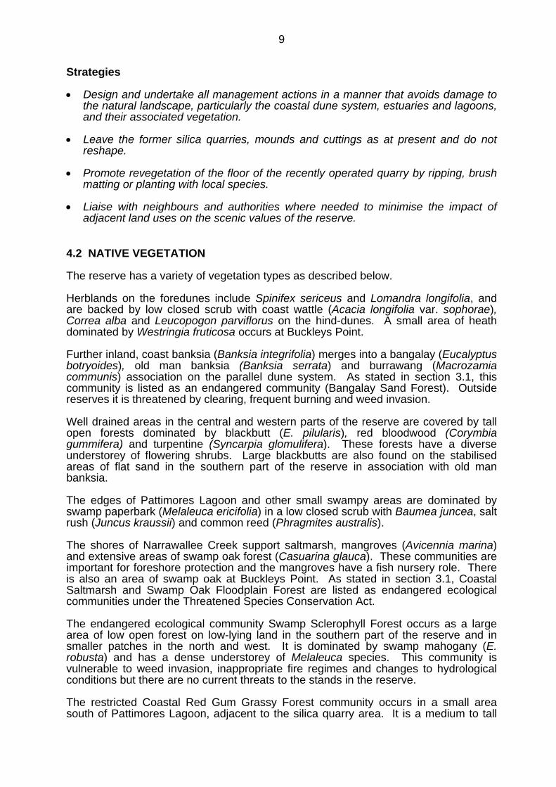
Vehicle access to the nature reserve is provided to a car park behind Conjola Beachand another on the western edge of the reserve, at the northern end of NarrawalleeCreek Road (see Map). Narrawallee Creek Road is maintained by local residents andfor this reason reserve visitors are directed to leave their cars in the car park providedjust off Lake Conjola Entrance Road.
All other access to the reserve is by foot, bicycle or boat. Management trails andwalking tracks provide opportunities for short and medium length walks through thereserve and enable visitors to experience a variety of forest and estuarineenvironments.
The main visitor facility is the Conjola Beach day use area, which provides access forbeach users and walkers. There is a fenced board and chain walkway across thedunes with a small viewing platform and a walking track leading to Buckleys Point.Picnic tables are located adjacent to the car park but not barbecues. Wood fires arenot permitted in the reserve in order to avoid environmental damage by woodgathering and to reduce potential for bushfire ignition.
Access to Conjola Beach is also provided across the reserve via a short walkway froma car park outside the northern boundary. This track may be affected by a wastewatertreatment plant to be constructed adjacent to the reserve.
The features of primary interest to visitors, apart from Conjola Beach, are PattimoresLagoon, the Inlet foreshores, rock platforms, varied vegetation communities, the silicaquarry and tramline remains. Provision of information about visitor opportunities andinterpretation of the reserve’s significant natural values and cultural heritage would bedesirable. Information provision assists the protection of natural and cultural heritage,encourages support for conservation and increases the enjoyment and satisfaction ofvisitors. The most appropriate locations for provision of interpretive information are atthe Conjola Beach car park and possibly at the silica quarry.
A low key boardwalk and small viewing platform have been provided across awaterlogged area at the northern end of Pattimores Lagoon, to provide access for birdwatching.
24
Cycling is an occasional activity on the management trails and has little impactbecause of the relatively flat topography.
Unauthorised horse riding occurs on the fire trails, walking tracks and beaches. Horseriding will continue to be prohibited because of the conservation priorities of naturereserves. Horse riding is also prohibited by Council on Conjola Beach outside thereserve.
Narrawallee Inlet is popular for boating but there is no known boating use ofPattimores Lagoon. The lagoon is small and very shallow and any boating activitycould significantly disturb birds using the lagoon.
School educational visits and community or commercial guided tours focussed onpromoting understanding and appreciation of natural and cultural values may beappropriate in the reserve. Group size, frequency and other aspects would need to beregulated to minimise impacts. Large groups in particular have the potential to haveenvironmental impact. It is very important for quality interpretive information andpromotion of minimal impact use to be included in group programs.
Desired Outcomes
• Visitor use is compatible with the purposes of nature reserves and is ecologicallysustainable.
• There is community understanding and appreciation of the reserve’s natural andcultural values.
• The reserve is a useful educational resource for local schools and communityorganisations.
Strategies
• Continue to allow vehicle access within the reserve to the Conjola Beach car park.Consider allowing vehicle access from the Conjola Beach access road to near theformer silica quarry, about 200m along the Silica Ridge Trail as part of aninterpretive strategy to be prepared for the reserve (see below).
• Maintain the Conjola Beach day use area with a car park, picnic tables, beachaccess track, viewing platform and walking tracks to Buckleys Point andNarrawallee Inlet.
• Maintain the car park at the beginning of Narrawallee Creek Road.
• Liaise with Council to determine the future of the beach access track at thenorthern end of the reserve and the need for re-design following construction of thewastewater treatment plant.
• Encourage public understanding and appreciation of the natural and cultural valuesof the reserve through such means as interpretive signs, brochures or mediaarticles.
• Prepare and implement an interpretation plan for the reserve. The plan will providefor provision of information at the Conjola Beach car park and will also considerinterpretive signs for the former silica mining operation at the quarry and tramline.
25
It may include associated works such as a car park and marked walkway at thesilica quarry. The plan will consider information needs and interpretive themessuch as:- cultural heritage (particularly the silica mining);- biodiversity and significant vegetation communities; and- Pattimores Lagoon and estuarine habitats.
• Design information and interpretive programs to promote care for the environmentand assist management to protect natural and cultural heritage values.
• Permit school, community and commercial tour operations that promoteunderstanding and appreciation of natural and cultural values subject to thefollowing:- use being confined to existing tracks;- provision of accurate and adequate interpretive information; and- limits on group size and frequency of use to minimise environmental impacts
and conflict with other users.
• Prohibit wood fires but permit visitors to use their own gas barbecues at theConjola Beach day use area (subject to normal fire restrictions).
• Prohibit camping and horse riding in the reserve.
• Permit bicycle riding on the Conjola Beach car park access road and managementtrails including the Mangrove Track but not on the Buckleys Point and PattimoresLagoon walking tracks.
• Prohibit boating on Pattimores Lagoon.
• Monitor visitor use and impacts.
26
7. OTHER USES
A telephone line along Conjola Entrance Road is partly located in the reserve and apowerline along Narrawallee Creek Road may also be partly in the reserve.Maintenance and access agreements will be arranged for these utilities so that theirimpact on the reserve’s plant communities is minimised.
Access for professional beach fishing occurs along the Buckleys Point Trail and willcontinue to be permitted in accordance with the Department’s Professional FishingAccess Policy.
There are several road reserves running through the nature reserve. Those to theeast of Narrawallee Creek Road do not have formed roads or do not lead to privateproperty. Arrangements will be made to have these added to the nature reserve. Asection of unconstructed road reserve parallel to the northern end of NarrawalleeCreek Road is also not needed and its addition to the nature reserve will be sought.
An addition to the nature reserve on the western side was made under the NationalParks Estate (Southern Region Reservations) Act 2000. The Act provided for certainpark boundary adjustments for public utilities. These are being negotiated withShoalhaven City Council for boundaries along Lake Conjola Entrance Road.
The Northern Link Trail runs largely along a road reserve through the western addition.It leads to private property but does not provide the primary access to this property.Gating of this trail would prevent illegal activities such as firewood collection from thenature reserve.
Some fencing has been erected on the western reserve boundaries to curb illegal orinappropriate activities such as firewood collecting, rubbish dumping, horse riding andvehicle access.
Desired Outcomes
• Non-reserve uses have minimal impact on natural and cultural heritage.
Strategies
• Vehicle access will continue to be permitted for authorised professional beachfishers via the Buckleys Point Trail.
• Enter into maintenance and access agreements for utilities, with the aim ofminimising impact on the reserve’s plant communities.
• Seek addition to the nature reserve of the road reserves east of Narrawallee CreekRoad and the unconstructed road reserve parallel to Narrawallee Creek Road.
• Explore options in conjunction with neighbours for controlling vehicle access alongthe Northern Link Trail.

27
8. MONITORING AND RESEARCH
The purpose of scientific study in the reserve is to improve understanding of its naturaland cultural heritage values, the processes that affect them and the managementneeds of specific species and features.
Under the Southern Regional Forest Agreement all forest managers including ForestsNSW, Dept of Lands and the Service must demonstrate ecologically sustainable forestmanagement (ESFM). ESFM aims to maintain or increase the full suite of forestvalues for present and future generations across the NSW native forest estate,including:- ecosystem biodiversity, health, vitality, productive capacity and functional
processes;- soil and water productive capacity and functional processes;- long term social and economic benefit; and- natural and cultural heritage values. ESFM will be applied to all ecosystem types and implemented primarily throughmonitoring to provide feedback on management programs and directions for futureadaptive management. Criteria and indicators of ecologically sustainable forestmanagement have been identified and monitoring programs are being introduced todemonstrate the impact of management actions on ecological functions. Remedialmanagement actions will be undertaken as required. Research and monitoring will be undertaken as part of Regional ESFM programs andalso for specific purposes as identified in this plan. Service monitoring and researchefforts must be directed towards the areas of greatest need and will concentrate on:- threatened species for which the reserve provides significant habitat;- endangered ecological communities;- the condition of Pattimores Lagoon;- fire management; and- cultural heritage features.
Additional research programs will be considered where they complement ESFMcriteria and indicators. The results of research and monitoring will be used to guidemanagement programs.
Research by other organisations and students plus observations by individuals andgroups such as bird watchers may also provide valuable information for management.A prospectus will be prepared to encourage involvement of other organisations inpriority research areas.
The Service has begun a program of assessing and reporting on the condition andmanagement adequacy of reserves through the State of Parks Program. This utilisesa number of indicators related to the condition of natural and cultural heritage andvisitor facilities, information availability and the management of threats such as fire andpests. Assessment of Narrawallee Creek Nature Reserve indicates that overall it is ingood condition.
Desired Outcomes
• Research is undertaken that enhances the information base and assistsmanagement of the reserve.
• Research causes minimal environmental damage.
28
• Monitoring programs are in place to detect any changes in the status of reservevalues and are used to guide management decisions.
Strategies
• Apply the principles of Ecologically Sustainable Forest Management to reservemanagement operations. Develop ESFM monitoring programs where needed anduse the results to guide management programs.
• Undertake research to provide information about the reserve’s natural and culturalheritage and human use in order to assist management. Give priority to researchneeds identified within this plan of management.
• Permit appropriate research by other organisations and individuals and promoteresearch that is directly useful for management purposes, particularly on the topicslisted above.
• Require any research structures and long term markers to be placed in locationsthat will minimise their visual impact and require their removal upon completion ofthe research.
• Prepare a prospectus to promote and guide research by other organisations intoprograms useful for management purposes, in particular targeted flora and faunasurveys and site monitoring for threatened species, Aboriginal sites and silicaquarrying.
• Encourage bird watchers and similar groups to pass on information gathered in thereserve.
29
9. NPWS MANAGEMENT FACILITIES AND OPERATIONS
The only management facilities in the reserve are vehicle trails; both those open topublic vehicle use (road to Conjola Beach car park) and those maintained formanagement purposes such as fire suppression and pest control (management trails).These are shown on the Map.
All management trails are gated and vehicle access is only permitted for managementpurposes and licensed professional fishers.
A number of organisations and individuals have an interest in management of thenature reserve, particularly neighbours with regard to such issues as fire management,weed and pest animal control, fencing and public access. On-going communicationwith a range of individuals, community groups and agency representatives will beneeded.
Desired Outcomes
• Management facilities adequately serve management needs and have acceptableenvironmental impact.
• A good relationship is maintained with reserve neighbours.
Strategies
• Maintain vehicle trails to a stable and trafficable condition as far as resourcespermit.
• Avoid use of the Mangrove Track in wet conditions unless essential for emergencypurposes such as fire suppression.
• Continue to gate all management trails.
• Maintain close liaison with neighbours of the reserve to deal with matters of mutualconcern, such as boundary issues and pest and fire management.

30
10. PLAN IMPLEMENTATION
This plan of management establishes a scheme of operations for Narrawallee CreekNature Reserve. It will remain in force until amended or replaced in accordance withsection 73B of the NPW Act. The plan is part of a system of management whichincludes the National Parks and Wildlife Act, management policies, establishedconservation and recreation philosophies, and strategic planning at corporate,directorate and regional levels. The latter may include development of related planssuch as species recovery plans, fire management plans and conservationmanagement plans.
Relative priorities for activities identified in this plan are set out in the table below.These priorities are subject to the availability of necessary staff and funds, and to anyspecial requirements of the Director-General or Minister.
The environmental impact of proposed activities will be assessed at all stages inaccordance with established environmental assessment procedures. If the impacts ofany activity proposed in this plan are found to be unacceptable, the activity will not beundertaken or will be modified so as to comply with the environmental assessmentoutcomes.
Strategies
• Undertake an annual review of progress in implementing this plan of management.
• Undertake an assessment after 5 years of the effectiveness of managing thereserve in accordance with this plan and of the degree of success in achieving theplan’s objectives and desired outcomes. Base the evaluation on the monitoringprograms set out in this plan and any others that may be developed.
Implementation Table
Priority Activity Planreference
High Monitor shorebird nesting and erect protective fencing as needed. 4.3Determine the former use of the corrugated iron shed, fence andwater tank and assess their significance. Develop a managementstrategy if found to be significant or record and remove if notsignificant.
4.5
Liaise with Council to seek rebuilding of the weir on thecanal development near Pattimores Lagoon, with the aim ofreturning the lagoon to near natural levels of salinitycompatible with restoring natural aquatic communities.Liaise as needed with the Department of Primary Industries,Department of Natural Resources and other relevantagencies. Undertake an education campaign withneighbours to raise understanding of the lagoon’s valuesand support for the rebuilding of the weir.
5.2
Undertake research as needed to record the current condition ofPattimores Lagoon and monitor changes following rebuilding ofthe weir.
5.2
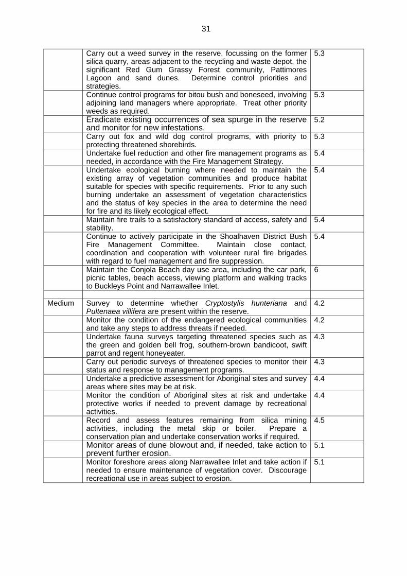
31
Carry out a weed survey in the reserve, focussing on the formersilica quarry, areas adjacent to the recycling and waste depot, thesignificant Red Gum Grassy Forest community, PattimoresLagoon and sand dunes. Determine control priorities andstrategies.
5.3
Continue control programs for bitou bush and boneseed, involvingadjoining land managers where appropriate. Treat other priorityweeds as required.
5.3
Eradicate existing occurrences of sea spurge in the reserveand monitor for new infestations.
5.2
Carry out fox and wild dog control programs, with priority toprotecting threatened shorebirds.
5.3
Undertake fuel reduction and other fire management programs asneeded, in accordance with the Fire Management Strategy.
5.4
Undertake ecological burning where needed to maintain theexisting array of vegetation communities and produce habitatsuitable for species with specific requirements. Prior to any suchburning undertake an assessment of vegetation characteristicsand the status of key species in the area to determine the needfor fire and its likely ecological effect.
5.4
Maintain fire trails to a satisfactory standard of access, safety andstability.
5.4
Continue to actively participate in the Shoalhaven District BushFire Management Committee. Maintain close contact,coordination and cooperation with volunteer rural fire brigadeswith regard to fuel management and fire suppression.
5.4
Maintain the Conjola Beach day use area, including the car park,picnic tables, beach access, viewing platform and walking tracksto Buckleys Point and Narrawallee Inlet.
6
Medium Survey to determine whether Cryptostylis hunteriana andPultenaea villifera are present within the reserve.
4.2
Monitor the condition of the endangered ecological communitiesand take any steps to address threats if needed.
4.2
Undertake fauna surveys targeting threatened species such asthe green and golden bell frog, southern-brown bandicoot, swiftparrot and regent honeyeater.
4.3
Carry out periodic surveys of threatened species to monitor theirstatus and response to management programs.
4.3
Undertake a predictive assessment for Aboriginal sites and surveyareas where sites may be at risk.
4.4
Monitor the condition of Aboriginal sites at risk and undertakeprotective works if needed to prevent damage by recreationalactivities.
4.4
Record and assess features remaining from silica miningactivities, including the metal skip or boiler. Prepare aconservation plan and undertake conservation works if required.
4.5
Monitor areas of dune blowout and, if needed, take action toprevent further erosion.
5.1
Monitor foreshore areas along Narrawallee Inlet and take action ifneeded to ensure maintenance of vegetation cover. Discouragerecreational use in areas subject to erosion.
5.1

32
Seek water quality monitoring by Shoalhaven City Council atPattimores Lagoon and other locations within the reservethat may be affected by the construction of the wastewatertreatment plant and dune exfiltration system at LakeConjola. The monitoring program should include anassessment of water quality prior to operation of the plantand consideration of inputs from local caravan parks.
5.2
Encourage effective boundary fencing with neighbouringgrazing properties by working closely with neighbours.
5.3
Continue to support and encourage community volunteer bushregeneration programs in the reserve.
5.3
Set up further fire monitoring plots in order to monitorvegetation changes in frequently burnt areas adjacent toLake Conjola village. Periodically resurvey plots.
5.4
Encourage public understanding and appreciation of thenatural and cultural values of the reserve through suchmeans as interpretive signs, brochures and media articles.
6
Prepare and implement an interpretation plan for the reserveincluding provision of information at the Conjola Beach carpark.
6
Maintain the car park at the beginning of Narrawallee CreekRoad.
6
Liaise with Council to determine the future of the beach accesstrack at the northern end of the reserve and the need for re-designfollowing construction of the wastewater treatment plant.
6
Explore options in conjunction with neighbours for controllingvehicle access along the Northern Link Trail.
7
Maintain vehicle trails to a stable and trafficable condition asfar as resources permit.
9
Low Promote revegetation of the recent quarry floor by ripping, brushmatting or planting with local species as required.
4.1
Liaise with neighbours and land use authorities to encourageretention of areas of native vegetation close to the reserve.
4.3
Work with Council to explore strategies for minimising rubbishdumping.
5.2
Seek to introduce cooperative feral cat control programs withneighbours.
5.3
Undertake on-going review of the impacts of prescribed burningon vegetation composition and structure. Where appropriate,modify programs to minimise adverse impacts.
5.4
Monitor visitor use and impacts. 6Enter into maintenance and access agreements for utilities, withthe aim of minimising impact on the reserve’s plant communities.
7
Seek addition to the nature reserve of the road reserves east ofNarrawallee Creek Road and the unconstructed road reserveparallel to Narrawallee Creek Road.
7
Undertake research to provide information about the reserve’snatural and cultural heritage and human use in order to assistmanagement.
8
Prepare a prospectus to promote and guide research by otherorganisations into programs useful for management purposes, inparticular targeted flora and fauna surveys and site monitoring forthreatened species, Aboriginal sites and silica quarrying.
8
Legend

33
High priority activities are those imperative to achievement of the objectives anddesired outcomes. They must be undertaken in the near future to avoid significantdeterioration in natural, cultural or management resources.
Medium priority activities are those that are necessary to achieve the objectives anddesired outcomes but are not urgent.
Low priority activities are desirable to achieve management objectives and desiredoutcomes but can wait until resources become available.
34
REFERENCES
Department of Environment and Conservation (2004) Invasion of Native PlantCommunities by Bitou Bush/Boneseed, Draft Threat Abatement Plan.
Findlay, A.G. 1988 The Environmental History and Trophic Status of PattimoresLagoon, Lake Conjola. University of NSW thesis.
Healthy Rivers Commission (2002) Independent Inquiry into Coastal Lakes FinalReport.
McAndrew, A (1995) The Narrawallee Story Retold. Alex McAndrew, Epping.
Ngh environmental 2004 Report for Mapping of Forest Ecosystems of NarrawalleeCreek Nature Reserve. Report prepared for NPWS.
Ngh environmental 2004 Vegetation Response to Fire Monitoring in NarrawalleeCreek Nature Reserve, Conjola and Morton National Parks. Report prepared forNPWS.
NPWS (1992) Narrawallee Creek Nature Reserve Interim Management Guidelines.
NPWS (2001) Predation by the Red Fox (Vulpes vulpes), Threat Abatement Plan.
Olsen, R & Latimer, B 1998 Wild Dog and Fox Survey Report for Cudmirrah andConjola National Parks, report to NPWS.
Shoalhaven City Council (1993) Narrawallee Creek Local Environment Plan.
Shoalhaven City Council (Undated) Fuel Management Plan.
Shoalhaven City Council 1998 Lake Conjola Estuary Management Plan.