Embed Size (px)
Citation preview

Lao – 4
Nam Theun/Cading
Map of River
Table of Basic Data
Name: Nam Theun/Cading (at Signo) Serial No: Lao - 4
Location: Barikhamxay Province N: 17° 50’42” E: 105° 03’06”
Basin Area: 3 370 km2 (at Signo) Length of main stream: 138 km
Origin: Sayphoulouang (2 200 m) Highest Pt. : 2 288 m
Outet : Pakcading Lowest Pt. : 155 m
Main geological features : Mesozoic, Cretaceaus, Permiam and Proterozoic, Precambrian.
Main tributaries: Nam One, Nam Noy, Nam Xot, Nam Kata
Main Lakes : Nam Theun II project (on going) 450 km2
Main reservoirs : Nam Theun II (project)
Mean annual precipitation: 2 500 mm (1986~1998)
Mean annual runoff: 222.83 m3/s at Signo (3 370 km2 ) (1985~1998)
Population : 103 000 (1998) Main cities: Nakai, Khamkheut
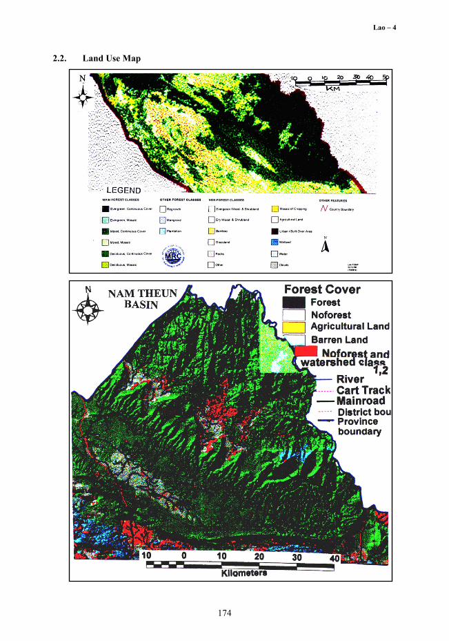
Lands use: Forest (60 %), Agriculture (25 %), Urban (1.5 %), Wetland (0.48 %), River (8 %), Others (12.22 %) (1998)
172
Lao – 4
1. General Description
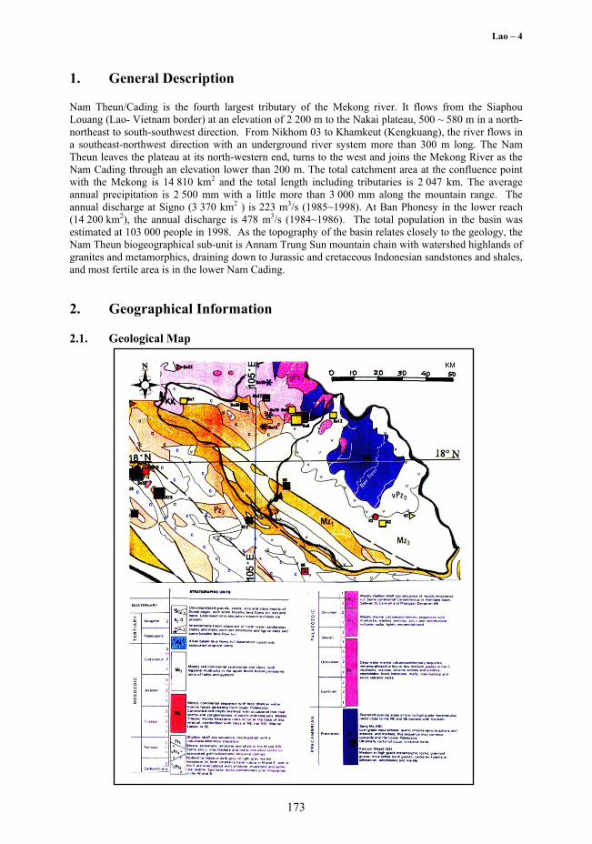
Nam Theun/Cading is the fourth largest tributary of the Mekong river. It flows from the Siaphou Louang (Lao- Vietnam border) at an elevation of 2 200 m to the Nakai plateau, 500 ~ 580 m in a north-northeast to south-southwest direction. From Nikhom 03 to Khamkeut (Kengkuang), the river flows in a southeast-northwest direction with an underground river system more than 300 m long. The Nam Theun leaves the plateau at its north-western end, turns to the west and joins the Mekong River as the Nam Cading through an elevation lower than 200 m. The total catchment area at the confluence point with the Mekong is 14 810 km2 and the total length including tributaries is 2 047 km. The average annual precipitation is 2 500 mm with a little more than 3 000 mm along the mountain range. The annual discharge at Signo (3 370 km2 ) is 223 m3/s (1985~1998). At Ban Phonesy in the lower reach (14 200 km2), the annual discharge is 478 m3/s (1984~1986). The total population in the basin was estimated at 103 000 people in 1998. As the topography of the basin relates closely to the geology, the Nam Theun biogeographical sub-unit is Annam Trung Sun mountain chain with watershed highlands of granites and metamorphics, draining down to Jurassic and cretaceous Indonesian sandstones and shales, and most fertile area is in the lower Nam Cading.
2. Geographical Information
2.1. Geological Map
173
Lao – 4
2.2. Land Use Map
174
Lao – 4
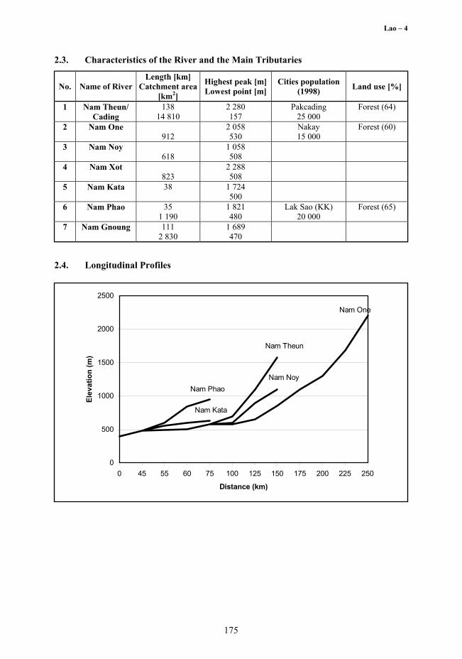
2.3. Characteristics of the River and the Main Tributaries
No. Name of River Length [km]
Catchment area [km2]
Highest peak [m] Lowest point [m]
Cities population (1998) Land use [%]
1 Nam Theun/ Cading
138 14 810
2 280 157
Pakcading 25 000
Forest (64)
2 Nam One 912
2 058 530
Nakay 15 000
Forest (60)
3 Nam Noy 618
1 058 508
4 Nam Xot 823
2 288 508
5 Nam Kata 38
1 724 500
6 Nam Phao 35 1 190
1 821 480
Lak Sao (KK) 20 000
Forest (65)
7 Nam Gnoung 111 2 830
1 689 470
2.4. Longitudinal Profiles
0
500
1000
1500
2000
2500
0 45 55 60 75 100 125 150 175 200 225 250
Distance (km)
Elev
atio
n (m
)
Nam One
Nam Noy
Nam Theun
Nam Kata
Nam Phao
175

Lao – 4
3. Climatological Information
3.1. Annual Isohyetal Map and Observation stations
3.2. List of Meteorological Observation Stations
No Station Elevation [m] Location Observation
period
Mean annual precipitation
[mm]
Mean annual evaporation
[mm]
Observation items1)
224* Khongsedone 122 N 15o34' E 105o48'
1965~94 1929~90
1 658 1 716
P,E
225* Pakse 101.5 1951~96 1 942 1 550~ 2 000
P,E,SR,DS
226* Paksong 1 200 1965~94 3 403 Piche 550
227* Salavane 168 1960~94 1 999 Pan'A' 2 073
P(TB),E,SR, DS
242* Selabam 117 1972~94 1 929 P 270* LaoNgam 451 1991~95
1989~93 1 760 1 780
P
Vangkaman 302 May~Dec 1995
P (TB)
260 Nonghine 1 280 1980~94 2 844 P Thateng 800 1993~95 2 123 P MuangVapi 160 1991~96 1 704 P KengSin 180 1993~96 2 416 P
1) P: precipitation; E: evaporation; SR: solar radiation; DS: Duration of sunshine; P(TB): tipping bucket raingage
176

Lao – 4
3.3. Monthly Climate Data
Station: Paksan Observation
item Jan Feb Mar Apr May Jun Jul Aug Sep Oct Nov Dec Annual Period for the mean
Temperature [°C]
20.6 22.8 25.2 26.9 26.9 26.8 26.1 26.3 26.3 25.2 23.4 21.1 24.8 1933~44
Precipitation [mm]
3.8 30.8 75.9 120.9 431.2 599.2 674.1 479.3 389.3 146.8 31.7 2.8 2 986 1933~44
Evaporation [mm]
15.8 18.3 21.0 24.2 26.3 28.2 27.5 26.8 26 22.8 18.2 16.5 21.5 1933~44
Duration of sunshine [hr]
221.6 192.7 240.4 205.9 157.3 96.7 78.5 84.2 141.3 202.5 231.2 218.5 1938~44
3.4. Longterm Variation of Monthly Precipitation Series
Monthly Rainfall Series in SIGNO (1986-1998)
0
400
800
1200
1600
19861991
1996
Month & Year
Rai
nfal
l (m
m)
Monthly Rainfall
Moving Average 37 months
177

Lao – 4
4. Hydrological Information
4.1. Map of Streamflow Observation Stations
4.2. List of Hydrological Observation Stations
No. Station Location Elevation [m]
Catchment area (A) [km2]
Observation period
Observation items 1)
(frequency) 1. Singo N 17° 50’ 7”
E 105° 03’ 1” 500 3 370 1985~1998 H2
2. Kengkuang N 18° 14’ 1” E 104° 39’ 7”
470 5 560 1985~96 1992~92 Q(d)
3. Phonsi N 18° 18’ 1” E 104° 05’ 9”
157 14 200 1960, 1967~71 78~80, 86~93 Q(d)
No. Q 2) [m3/s]
Q max 3) [m3/s]
Q max 4) [m3/s]
Q min 5) [m3/s/100 km2]
Q/A [m3/s/ 100 km2]
Qmax/A [m3/s/ 100 km2]
Period of statistic
1 222.83 3 040 1 775 20.42 6.612 90.208 1986~98
2 385.0 2 490 3 172 16.80 5.044 56.142 1986,90~93
3 478.0 6 000 4 910 59.95 3.366 34.577 1986, 91~93 1) H2 (d): water level reading twice daily; Q(d): daily discharge; 2) Mean annual discharge; 3) Annual maximum discharge; 4) Mean annual maximum discharge; 5) Mean annual minimum discharge
178

Lao – 4
4.3. Longterm Variation of Monthly Discharge Series
Monthly Mean Discharge at SIGNO (1985-1998)
0
400
800
1600
1985
1987
1989
1991
1993
1995
1997
Month & Year
Mean Discharge
Moving Average 37 months1200
Dis
char
ge (m
3/s)
Dis
char
ge (m
3 /s)
4.4. Annual Pattern of Discharge Series
Discharge & Flow Duration Curve in Signo 1987
0
400
800
1200
1600
2000
01-Jan 01-Mar 01-May 01-Jul 01-Sep 01-Nov
Date
DischargeFlow Duration Curve
Dis
char
ge (m
m)
Dis
char
ge (m
3 /s)
179

Lao – 4
4.5. Unique Hydrological Features D
isch
arge
(m3 /s
)
NamTheun at Signo (Catchment area = 3 370 km2)
4.6. Annual Maximum and Minimum Discharges
Station: At Ban Signo Catchment Area: 3 370 km2
Maximum Minimum Year Date Discharge 1) [m3/s] Month Discharge 2) [m3/s] 1986 9.8 1 280 - - 1987 8.22 1 890 4 14.4 1988 8.11 1 270 3 15.0 1989 7.25 1 770 4 38.4 1990 8.3 1 930 4 16.0 1991 8.2 2 060 6 14.0 1992 6.3 1 520 5 7.38 1993 7.14 1 480 3 16.4 1994 8.1 2 330 4 17.7 1995 9.2 1 696 5 16.6 1996 9.16 3 040 4 48.4 1997 8.17 1 787 4 23.6 1998 7.4 1 011 3 17.1 Sum 23 064 244.98
Mean 1 774.16 20.42
180

Lao – 4
4.7. Hyetographs and Hydrographs of Major Floods
Rai
nfal
l (m
m)
Dis
char
ge (m
3 /s)
5. Water Resources
5.1. General Description
The Nam Theun / Cading, where the upper part is in Khammouane Province while the middle and the lower areas are in Bolikhamxay Province in Central Lao, has several tributaries: as illustrated on map of streamflow, the upper reaches in the plateau consist of Nam One, Nam Noy and Nam Theun that have total length of 138 km; the middle tributaries consist of Nam Xot, Nam Kata and Nam Phao with 38 km and 35 km long than they join the Nam Theun; and the lower tributary is Nam Gnoang of 111 km long and drainage area 2 800 km2 joins the NamTheun downstream of KengKuang gauging station. In the middle reach of Nam Cading there is an important tributary (Nam Mouan), still an ungauged river.
The floods of more than 2 000 m3/s at Signo (3 370 km2) were frequently observed. On the 12th of September1996, the water stage was 1.95 m than beginning the 14th September rise to 14.27 m as resulted from a tropical cyclone which corresponded to an increase in river discharge from 130 to 3 040 m3/s. These peak stage and discharge were the highest in the 10-year period of stream gauge operation. The second tropical storm on the 22nd of September caused a peak of 15.78 m water level (2 850 m3/s) on the 24th that same month. It was concluded that the 1996 was the wettest year in ten years. However, the interannual variability is of importance. During the EL NINO years, with less rainfall in 1987 (1 427 mm) or much rainfall in 1997 (3 050 mm) – the NamTheun and its tributaries have many promising projects for flood control and hydropower. The Nam Phao mini hydro is operational and supplies 2 MW to Laksao city, NamTheun 3 Power project (Nam Gnouang or Nam Nhoang) is under study, and NamTheun 0 - Hinboun Power project is a 210 MW Trans-basin run off river hydropower is already operational.
The NamTheun 2 Hydropower project involves the development of a hydroelectric scheme in Central Lao PDR (see Map of water resource systems in 5.2). The scheme involves constructing a dam on the
181

Lao – 4
182
NamTheun approximately 160 km upstream of its confluence with the Mekong River. This would create a reservoir on the Nakai Plateau which would necessitate the relocation of about 900 families or 4 500 people who would be resettled at higher elevations on the Plateau. The catchment area near the dam is 4 013 km2 and the reservoir is estimated to inundate 450 km2 or 40 % of the Nakai Plateau when at full supply level. Water from the reservoir would drop more than 350 meters in a diversion tunnel to the powerhouse and then flows to another river system, the Sebangfay which also flows into the Mekong about 150 km south of NamTheun. A Transmission line to the Thai border and the construction or upgrade of more than 200 km of roads are additional components of the project and another water resources in the NamTheun Nakai Plateau. It constitutes a synclinal basin which varies in width from 15 to 35 km and which has an area of 1 618 km2 where habitat for rare species exists in a rich natural environment. There are indications that the area support an uncommon diversity of habitats and wildlife natures, which will be dependent on the wetlands in some way, usually for water in the dry season. From this important hydropower project, the peak power is estimated to be 600 MW, four times the Nam Ngum I project power.
5.2. Map of Water Resource System
5.3. Major Flood And Drought Experiences
Major Flood
Date Station
Catchment area [km2]
Peak discharge
[m3/s]
Rainfall [mm]Duration
Meteorological causes
Major damages (District affected)
12/9/96 Signo 3 370
3 040 288.0 12~15 Sept.
Typhoon Downstream of Kanang rice field flooded
in lower Nam Cading
Major Drought
Period Areas affected Major damages and counteractions 1~16 July 1997 Lower Nam Cading Rice crops

Lao – 4
5.4. Water quality
183
Para
met
ers
Uni
t N
.The
un
Sign
o N
.The
un
Dam
site
N
.The
un
Sign
o N
.The
un
Dam
site
N
.The
un
Sign
o N
.The
un
Dam
site
N
.The
un
Sign
o N
.The
un
Dam
site
N
.The
un
Sign
o N
.The
un
Dam
site
D
ate
30
/06/
95
30/0
6/95
30
/07/
95
31/0
7/95
30
/08/
95
31/0
8/95
7/
94
7/94
30
/09/
94
30/0
9/94
pH
6.65
6.
78
6.44
6.
54
6.51
6.
34
6.24
6.
28
6.31
7.
59
Con
duct
ivity
m
s/m
2.
7 2.
6 1.
9 1.
7 1.
39
1.32
1.
3 1.
4 2.
2 27
.1
Ca
meg
/l 0.
139
0.11
9 0.
093
0.08
7 0.
063
0.05
9 0.
063
0.04
6 0.
088
2.30
2 M
g m
eg/l
0.07
1 0.
079
0.07
6 0.
061
0.06
8 0.
068
0.07
1 0.
055
0.05
8 0.
679
Na
meg
/l 0.
048
0.02
7 0.
047
0.03
1 0.
028
0.02
9 0.
045
0.01
3 0.
055
0.02
2 K
m
eg/l
0.00
5 0.
003
0.00
5 0.
007
0.01
6 0.
015
0.03
0 0.
033
0.01
3 0.
008
NH
4-N
m
g/l
0.10
5 0.
041
0.04
2 0.
046
0.08
8 0.
070
0.02
4 0.
023
0.01
1 0.
005
Cl
meg
/l 0.
022
0.01
8 0.
008
0.02
4 0.
015
0.01
6 0.
182
0.10
4 0.
139
0.12
8 SO
4 m
eg/l
0.07
0 0.
223
0.00
6 0.
043
0.07
9 0.
055
0.05
6 0.
060
0.11
0 2.
950
Alk
alin
ity
meg
/l 0.
143
0.12
1 0.
098
0.08
5 0.
078
0.09
9 0.
126
0.06
3 0.
051
0.03
5 N
O3-
N
mg/
l 0.
025
0.13
1 0.
074
0.08
6 0.
208
0.16
5 0.
123
0.15
6 0.
186
0.27
7 T
otal
P
mg/
l 0.
179
0.02
0 0.
034
0.04
9 0.
121
0.10
7 0.
047
0.15
6 0.
052
0.03
5 T
otal
Fe
mg/
l 6.
261
0.50
1 0.
825
0.65
2 0.
405
0.20
5 0.
103
0.08
1 0.
175
0.36
8 C
OD
Mn
38
.0
2.14
5 3.
079
2.79
9 6.
588
2.82
7 11
4 73
45
24
1 T
SS
mg/
l 0.
001
19.0
67
79
14
.8
92.4
0.
783
0.93
0 1.
593
0.45
8 M
n m
g/l
0.
001
0.00
1 0.
001
0.00
1 0.
001
0.00
1 0.
001
0 0

Lao – 4
6. Socio-Cultural characteristics
The Ethno-economic context of the watershed is characterized by human population of the Nakai - Nam Theun conservation area and adjacent peripheries that can be grouped according to ethnolinguistic classes which, although not equivalent, represent useful anthropological categories for planning and management. The vietic branch of Mon Khmer (Austro Asiatic) Brou is a single language, Hmong, refers to a single language belonging to the Hmong-Mien family. Nevertheless, within the Nam Theun catchment there is a fascinating variety of people who still preserve distinct cultural traditions to a remarkable degree. In 1995 a UNESCO representative visited the Nakai Nam Theun Khammouane area and recommended that the Lao government seeks technical assistance available through World Heritage Fund to assess the suitability of the area for Natural Heritage nomination.
7. References, Databooks and Bibliography Department of Geology and Mining, (1991): 1:1 000 000 Scale Map of Geological and Mineral
Occurrence Map of Lao PDR, 1990~1991. DMH, (1998): Hydroclimatic data available prior to 1998. Integrated Resources Center, (1994): Report No. 1 on Watersheds of Lao PDR, March 1994. IUCN, (1996): The World Conservation Union, Inventory of Wetlands in Lao PDR.
(1997): Draft of Nakai Namtheun Management Strategy, Vientienne. MRC (GTZ), (1998): Land Cover and Watershed Class of Khammouane Province. National Geographic Department, (1987): 1:1 000 000 Scale map and 1: 500 000 Scale Maps.
184


![Theun-Hinboun Hydropower Project (Loan 1329-LAO[SF])](https://img.dokumen.tips/doc/110x75/577ce66e1a28abf10392ca83/theun-hinboun-hydropower-project-loan-1329-laosf.jpg)