Embed Size (px)
Citation preview

MWH Softwater resource workgroup management software
for the worldwide water industry

With a heritage that stems from the UK’s
Hydraulics Research Station more than
half a century ago and a reputation for
world class products and services, the
MWH Soft Workgroup Management
Software is relied on by leading
engineering consultancies, utilities,
academic institutions and governments
across the globe. The company has
offices in the United Kingdom, United
States, Malaysia and Australia, and also
has a network of approved distributors
throughout Europe, Asia and the
Americas.
MWH Soft has an unrivalled reputation
for continuous development of
its functionally-rich planning and
operations software for the modeling
and management of water supply,
wastewater and river and coastal
systems.
1
MWH Soft has developed the world’s most comprehensive range of hydraulic, hydrological, water modeling and resource management software.
MWH Soft
This product catalogue has been designed to give you information about the MWH Soft Workgroup
Management Software. Use the handy index below to go straight to the product that’s most relevant
to your needs. If you need more information or details on the entire MWH Soft product line, do not
hesitate to contact your nearest office (details on page 34) or visit www.mwhsoft.com.
Are you interested in
Wastewater?
InfoWorks CS network modeling software see page 2
InfoWorks 2D surface flood modeling software see page 3
FloodWorks operational forecasting and warning software see page 18
InfoNet water asset and data management software see page 24
Are you interested in:
Stormwater?
InfoWorks SD network modeling software see page 4
InfoWorks 2D surface flood modeling software see page 7
FloodWorks operational forecasting and warning software see page 18
InfoNet water asset and data management software see page 24
Are you interested in
Water Supply and Distribution?
InfoWorks WS network modeling software see page 8
InfoNet water asset and data management software see page 24
Are you interested in
River and Coastal Systems?
InfoWorks RS network modeling software see page 12
FloodWorks flood forecasting and warning software see page 18
Are you interested in
Asset Management?InfoNet for water supply and wastewater including InfoNet Mobile
see page 24

InfoWorks CS
32
ApplicationsApplications include urban flooding and pollution
prediction and the modeling of water quality and
sediment transport throughout the network:
Undertake drainage and sewerage master
planning or studies
Assess the impact of climate change on
urban drainage systems
Effectively implement sustainable urban drainage
systems (SUDS)
Undertake hydraulic analysis of wastewater
treatment works
Identify solutions to intermittent discharges from
sewerage systems (UID´s, CSO´s or SSO´s)
Flooding and pollution prediction
Modeling of sediment transport and associated
water quality
Secondary drainage and urban storm water
system assessment and management
Wastewater system assessment and management
Infiltration and inflow assessments
Urban drainage storm runoff control and retention
design and assessment
Urban storm water quality assessments
and pollution control
Combined / wastewater interceptor system design
and analysis
ModulesThe software incorporates a number of modules,
most of which are provided as standard but
some are optional.
InfoWorks 2D Module2D functionality is available as a fully integrated
module within InfoWorks CS. This facilitates fast,
accurate and detailed surface flood modeling,
which is better for modeling flows through complex
geometries such as urban streets and buildings,
road intersections and other transport infrastructure.
InfoWorks 2D features the most modern of 2D engines
using a finite volume approach and a triangular
irregular mesh. All of this powerful 2D functionality
is fully and seamlessly integrated with the baseline
1D engine so a single simulation is all that’s needed
to analyze the interaction of underground and above
ground flows in the urban environment.
For more information about the modules standard in
InfoWorks CS and SD and InfoWorks CS Viewer
(Separately Licensed) please go to page 5.
InfoWorks CS allows engineers and planners to accurately simulate the
movement of wastewater through a collection system network.
This powerful and effective tool provides fast, accurate and robust hydraulic modeling
of the complete urban collection system network. This extends to full modeling of
backwater effects and reverse flow, open channels, trunk sewers, complex pipe
connections and ancillary structures. Urban flooding and receiving stream impact
prediction, water quality, sediment transport and real time control simulation tools all
come as standard with InfoWorks CS. A range of graphical or geographic views and
animated presentations provide access
to the underlying model data in user
friendly formats for ease of analysis and
presentation. Users can simulate models
of up to 100,000 nodes with confidence
that the results will be as accurate as
those for far smaller models.

A close relative of the powerful and internationally accepted InfoWorks
CS, InfoWorks SD is the industry’s first fully dynamic hydraulic
modeling solution, designed specifically to fulfil the demanding
requirements of storm water modeling in markets where the storm
water system is separate from
the sanitary system. InfoWorks
SD is available to our worldwide
customer base.
InfoWorks SD provides the ability to
model stormwater flows through a
complex environment, with its diversity of
underground and overland structures and
paths applying the same high quality of
function and analysis to open channels and
closed conduits. With the option of event-
based or real time continuous simulations, InfoWorks SD is ideal for infrastructure
design, evaluation projects and real time operational use. An enhanced version of
InfoWorks SD, complete with fully integrated 2D capability, is available as a value
added option.
54
InfoWorks SD
ApplicationsInfoWorks SD incorporates everything required
to model stormwater flows effectively:
Comprehensive modeling of stormwater
structures
Rapid and greenfield infiltration and inflow
Future scenario analysis as well as existing
network simulation
Integrated flood mapping to generate visual
representation of surface flood depths
Optional fully-dynamic, 2D surface flood
simulation, integrated with the pipe and
surface-channel hydraulic simulation
Models BMP design, construction and
maintenance practices and criteria for
stormwater facilities
Simulation of control structures
and control logic (Real Time Control)

76
ModulesThe software incorporates a number of modules to
support fast and accurate network modeling.
Infiltration Module (Standard in InfoWorks CS and SD)Unlike direct runoff, which responds to a rainfall
event in minutes, infiltration inflows have a much
slower response. The Infiltration Module allows users
to represent this late response within the network.
In networks where infiltration is dominated by tidal
influences, users can create a time-varying profile
for the groundwater storage level. This profile will
override the level calculated by the infiltration model
and groundwater infiltration is then based on this
level.
Snow Melt Module (Standard in InfoWorks CS and SD)A Snow Melt Module has been incorporated into
InfoWorks SD. The model is derived from the SWMM4
continuous simulation model. The Rainfall Event Editor
allows the user to define the initial snow conditions,
temperature profile and wind profile in addition to
the rainfall profile. The melt rate, snow depth and
free water depth results are available for any sub
catchments containing snow packs. The Snow Melt
Module operates by affecting rainfall before it reaches
the runoff surfaces. When temperature falls below
the dividing temperature between snow and rain,
the rainfall profile is treated as snow. A melt rate is
calculated for each surface type.
Real Time Control Module (Standard in InfoWorks CS and SD)Real Time Control (RTC) is the remote manipulation
of control structures within a drainage system,
based on conditions at any point in the system, in
order to optimize storage and operation. RTC can be
applied to individual, isolated, ancillary structures to
provide local control of flows. It can also make global
management of flows possible throughout an entire
network.
Water Quality Module (Standard in InfoWorks CS and SD)The InfoWorks SD Water Quality Module is designed
to help engineers develop cost effective solutions
for pollution and sedimentation problems. The Water
Quality Module can model physical processes such as
sediment built up behind closed gates and penstocks.
Using the Water Quality Module, engineers can
control pollution by targeting the SSO problems, and
predict quality components such as the volume of
spillage and flooding. This leads to recommendations
for corrective action through storage and real time
control.
Physical process models within the Water Quality
Module include a Surface Pollutant Build-up Model, a
Surface Pollutant Wash off Model, a Gully Pot Model,
a Sediment Transport Model and an In-pipe Water
Quality Model.
InfoWorks 2D Module 2D functionality is available as a fully integrated
module within InfoWorks CS and InfoWorks SD.
This facilitates fast, accurate and detailed surface
flood modeling, which is better for modeling flows
through complex geometries such as urban streets
and buildings, road intersections and other transport
infrastructure. InfoWorks 2D features the most
modern of 2D engines using a finite volume approach
and a triangular irregular mesh. All of this powerful
2D functionality is fully and seamlessly integrated
with the baseline 1D engine so a single simulation
is all that’s needed to analyze the interaction of
underground and above ground flows in the urban
environment.
InfoWorks Viewer (Separately Licensed)InfoWorks ‘Viewer’ will be of interest to those people
taking delivery of InfoWorks models from consultants,
and those who are involved with the auditing of
models built by others.
The InfoWorks ‘Viewer’ allows existing InfoWorks
databases to be imported and the data and results
to be viewed. Everything appears just as it does
in InfoWorks CS or SD (as applicable). It is fully
functional with its ability to view data and results in
the various graphical and grid views. This applies for
both static and time varying data and results. It is
also possible to import any Map layers (ArcView or
MapInfo), so the models appear exactly as they were
built. The entire audit trail resulting from the model
build process is also preserved. There is no restriction
on the size of model or length of simulation results
that can be viewed.
Because it is a ‘viewing only’ tool, it is not able to
amend any data, or set up any new simulations.
However, it can be used to re-run any simulations that
have previously been run to completion in a full copy
of InfoWorks CS or SD (as applicable). This avoids the
need to include results when producing transportable
databases that are being passed to a third party that
only has InfoWorks ‘Viewer’ and dramatically reduces
the size of the .IWC file.
InfoWorks CS and SD Modules

InfoWorks WS gives an accurate view of the performance of a water
distribution system so that a sustainable supply of high quality water
can be provided to commercial, industrial and domestic users, at an
acceptable pressure and
flow rate whilst minimizing
loss through leakage.
Standard practice of a
typical InfoWorks WS user
shows the advancements
possible, in that they will
be running continuous
simulations from day one,
not steady state snapshot
models.
More regulation, security concerns and climate change put increasing
responsibilities on water managers. InfoWorks WS allows competent and informed
decisions to be made and passed on to customers and senior management.
High quality all-mains InfoWorks WS models enable offline management decisions
to be made with confidence. These include water quality, supply, demand and
infrastructure problems and investigation of remedial measures.
InfoWorks WS
98
InfoWorks Platform offers a complete solution that
doesn’t require any add-on software or platform to
run. All the tools, simulations and data integration
needed are included in the single application.
Integrated fully with GIS including automated
model updates
Flexible multi-user environment
Efficient and back-end independent data storage
Automated version control and audit trail
Data source and result certainty management
through data flags
Designed for large model performance
InfoWorks Model Building is made simple with an
intuitive user interface which maximizes productivity,
reduces likelihood of errors and enables users to
move swiftly between modules. Powerful model
building tools include:
Multiple data import options
Flexible manual digitization
Automated data validation and error correction
Elevation extraction
Adjustable demand management
Linked customer management
Models both hydraulics and operation
of pumps and valves
Matching of any Programmable Logical
Controller (PLC)
Automated model calibrations
Integrated SCADA
Allows for both top-down and bottom-up
approaches to regional modeling
Customizable data validation, correction, and
analysis tools

1110
InfoWorks WS simulations have over 30 years of
refined development and use—resulting in the fastest
and most reliable engine on the market. Included
within the software are the following simulations:
Steady state and extended period hydraulic
analysis
Water quality engine
Fire flow simulation
Automatic capacity check
Sediment modeling
Main break isolation and shutdown simulation
Critical Link Assessment (CLA)
Unidirectional Flushing (UDF)
Cost of pumping
Cost of water
Water hammer/transient analysis
Leakage modeling
Pressure related demands
Automated optimization based on genetic
algorithms
ApplicationsPlanning of capital investments
Investigation of supply deficiencies
Scenario planning and fire flow analysis
Simulation of pollution incidents
Assessing source blending requirements
Optimization of pumping and storage systems
Water quality and chlorination assessment
Management of pressure related demand
Sedimentation analysis and mains flushing
Design and implementation of drought
management plans
Assessment of supply to individual customer level
InfoWorks results and reports are fully interactive and
allow the user to open any number of maps, tables,
profiles and graphs at the same time. Reporting
options include the following elements and
if desired, the user can create customized
MS Excel reports.
Map Views (GeoPlan)
Color Coding
Contours
Customizable Labelling
Tables
Graphs
Profiles
3D Views
Animation
Result Comparison
Derived Results
Object Groups
SQL Selection and Editing
Tracing Tools
Data and Results Export
Google Earth Export
Stored Views
Viewer Application
InfoWorks WS
InfoWorks WS Viewer (Separately Licensed)InfoWorks ‘Viewer’ will be of interest to those people
taking delivery of InfoWorks models from consultants,
and those who are involved with the auditing of
models built by others.
The InfoWorks ‘Viewer’ allows existing InfoWorks
databases to be imported and the data and results
to be viewed. Everything appears just as it does in
InfoWorks WS. It is fully functional with its ability
to view data and results in the various graphical
and grid views. This applies for both static and time
varying data and results. It is also possible to import
any Map layers (ArcView or MapInfo), so the models
appear exactly as they were built. The entire audit
trail resulting from the model build process is also
preserved. There is no restriction on the size of model
or length of simulation results that can be viewed.
Because it is a ‘viewing only’ tool, it is not able to
amend any data, or set up any new simulations.
However, it can be used to re-run any simulations
that have previously been run to completion in a full
copy of InfoWorks WS. This avoids the need to include
results when producing transportable databases
that are being passed to a third party that only has
InfoWorks ‘Viewer’ and dramatically reduces the size
of the .IWC file.
InfoWorks RS
1312
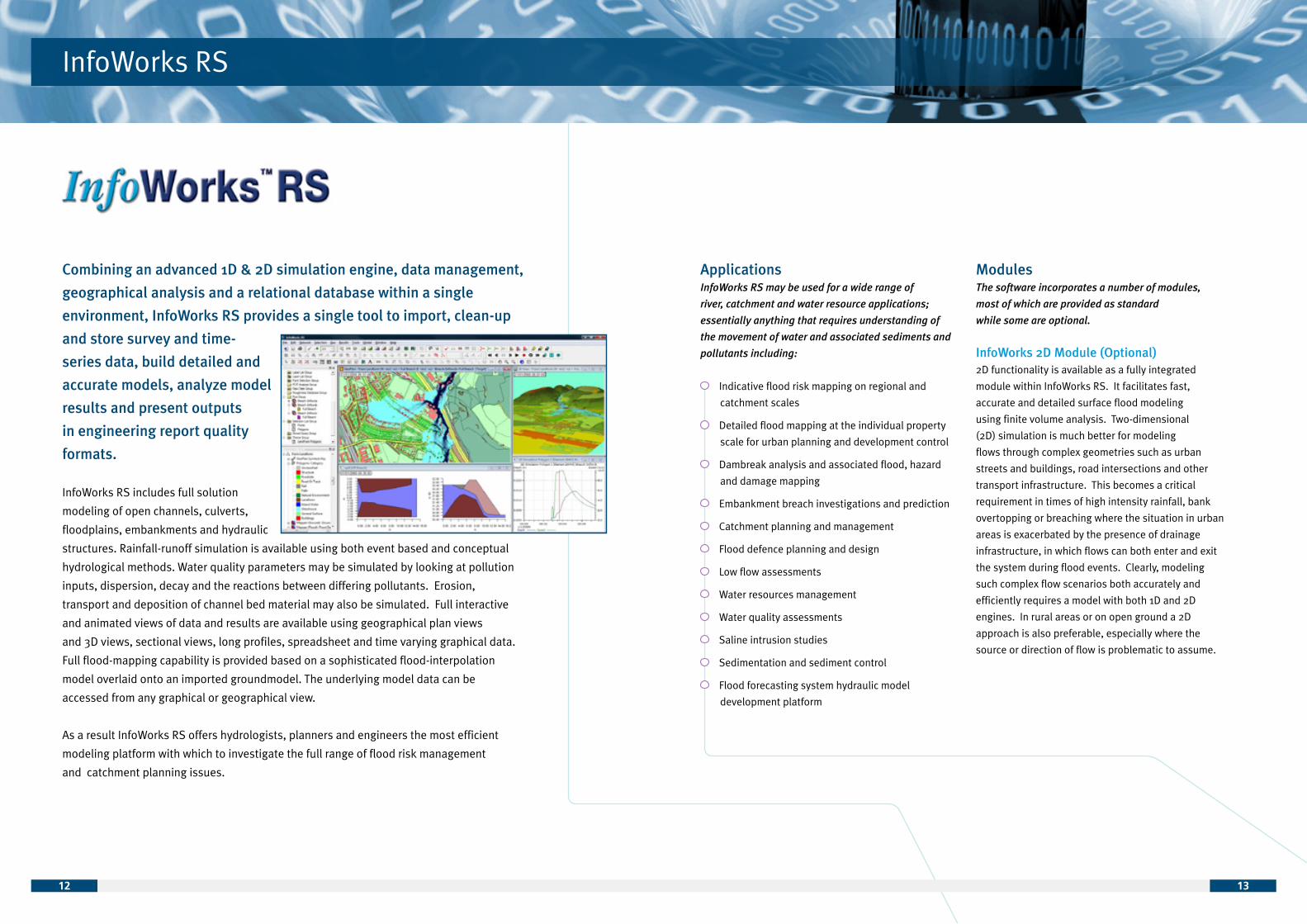
Combining an advanced 1D & 2D simulation engine, data management,
geographical analysis and a relational database within a single
environment, InfoWorks RS provides a single tool to import, clean-up
and store survey and time-
series data, build detailed and
accurate models, analyze model
results and present outputs
in engineering report quality
formats.
InfoWorks RS includes full solution
modeling of open channels, culverts,
floodplains, embankments and hydraulic
structures. Rainfall-runoff simulation is available using both event based and conceptual
hydrological methods. Water quality parameters may be simulated by looking at pollution
inputs, dispersion, decay and the reactions between differing pollutants. Erosion,
transport and deposition of channel bed material may also be simulated. Full interactive
and animated views of data and results are available using geographical plan views
and 3D views, sectional views, long profiles, spreadsheet and time varying graphical data.
Full flood-mapping capability is provided based on a sophisticated flood-interpolation
model overlaid onto an imported groundmodel. The underlying model data can be
accessed from any graphical or geographical view.
As a result InfoWorks RS offers hydrologists, planners and engineers the most efficient
modeling platform with which to investigate the full range of flood risk management
and catchment planning issues.
ApplicationsInfoWorks RS may be used for a wide range of
river, catchment and water resource applications;
essentially anything that requires understanding of
the movement of water and associated sediments and
pollutants including:
Indicative flood risk mapping on regional and
catchment scales
Detailed flood mapping at the individual property
scale for urban planning and development control
Dambreak analysis and associated flood, hazard
and damage mapping
Embankment breach investigations and prediction
Catchment planning and management
Flood defence planning and design
Low flow assessments
Water resources management
Water quality assessments
Saline intrusion studies
Sedimentation and sediment control
Flood forecasting system hydraulic model
development platform
ModulesThe software incorporates a number of modules,
most of which are provided as standard
while some are optional.
InfoWorks 2D Module (Optional)2D functionality is available as a fully integrated
module within InfoWorks RS. It facilitates fast,
accurate and detailed surface flood modeling
using finite volume analysis. Two-dimensional
(2D) simulation is much better for modeling
flows through complex geometries such as urban
streets and buildings, road intersections and other
transport infrastructure. This becomes a critical
requirement in times of high intensity rainfall, bank
overtopping or breaching where the situation in urban
areas is exacerbated by the presence of drainage
infrastructure, in which flows can both enter and exit
the system during flood events. Clearly, modeling
such complex flow scenarios both accurately and
efficiently requires a model with both 1D and 2D
engines. In rural areas or on open ground a 2D
approach is also preferable, especially where the
source or direction of flow is problematic to assume.

InfoWorks RS
1514
Bank/Levee & Dam Breach Module (Standard)InfoWorks RS offers dynamic simulation of the failure
of earth embankments that lie either across the
main channel to form dams or parallel to the channel
forming flood banks or levees. The module allows for
failure due to overtopping, piping or failure of surface
protection layers. The embankment is described
by its physical dimensions, material properties and
condition. The module can represent banks of both
homogeneous and composite construction and with a
range of surface protection measures.
The breach evolution is calculated by the erosive
capacity of the flow either over or through the bank.
Seven choices of sediment transport equation are
offered, depending on the materials used in the bank.
For piping failures the pipe diameter increases until
the structural stability of the roof is exceeded causing
the pipe to collapse and the failure continues as
an open breach. For open breaches the module
calculates both the vertical and horizontal erosion
rates to predict the change in breach shape and flow
characteristics. The module also assesses the slope
stability of the sides of the breach, can represent
headcutting and allows for collapse of bank material
in to the breach to form partial blockages.
Sediment Transport Module (Standard)This module enables the prediction of sediment
transport rates, bed elevations and amounts of
erosion/deposition throughout a channel system.
Various options are available including: specification
of dredging; cohesive sediment transport; and
rigid beds. Four sediment transport equations are
available:
Engelund-Hansen
Ackers-White
revised Ackers-White and
Westrich-Jurashek
All include a calibration factor which has the default
value of unity to give the published form of the
equations. A range of methods are offered for
updating the channel geometry.
Water Quality Simulation (Standard)InfoWorks Water Quality is used to model water
quality in open channels. It computes concentrations
using a finite difference approximation to the
advection-diffusion equation. Although InfoWorks
Water Quality is a depth averaged model, for mud
transport and water quality modeling an element is
divided into four vertical sub-components: the main
water column, the bed, the fluffy layer and pore
water. The contents of the fluffy layer can interact bio
chemically and biologically with the water column. The
material in the bed and pore water can interact but are
isolated from the water column until re-suspended.
Erosion of the fluffy layer and bed material returns
their contents and that of pore water to the water
column. InfoWorks Water Quality is capable of
modeling a range of water quality variables and
processes simultaneously. These include:
Conservative pollutants
Decaying pollutants
Coliforms
Salt
Water temperature
Sediment
Oxygen balance
Water/Sediment oxygen interactions
pH
Logical Control Module (Standard)Logical Control is the remote manipulation of control
structures within the model, based on conditions at
any point in the system, in order to optimize storage
and operation. Logical Control can be applied to
individual, isolated, ancillary structures to provide
local control of gate positions and opening, pump
status and abstraction discharges. It can also make
global management of water possible throughout an
entire network. For example, a rainfall of flow input
at the top of the system may operate a sluice gate or
outfall structure near the downstream limit.
Users can combine Logical Control modeling
parameters to build up complex rules. This provides
enormous scope to explore the potential storage
capacity and optimal operating patterns within
the system being modeled.

1716
InfoWorks RS
Conveyance Estimation (Standard)The Conveyance Estimation System or ‘CES’ is a
software tool that enables the user to estimate the
conveyance or carrying capacity of a channel. This
capacity is based on the ability of the channel to resist
the flow, driven by gravitational acceleration in terms
of channel gradient, through surface friction and
channel morphology, for example, cross-section shape
and platform sinuosity. The CES includes a component
termed the ‘Roughness Advisor’, which provides
advice on this surface friction or ‘roughness’, and a
component termed the ‘Conveyance Generator’, which
determines the channel capacity based on both this
roughness and the channel morphology.
In addition, the CES includes a third component,
the ‘Uncertainty Estimator’, which provides some
indication of the uncertainty associated with the
conveyance calculation. The primary outputs from the
CES components are:
Roughness Advisor: roughness values
Conveyance Generator: stage-conveyance
relationship
Uncertainty Estimator: upper and lower bands for
the stage-conveyance relationship
These three components are essential for determining
site-specific stage-conveyance curves. The CES has
a further module for calculating backwater curves
in reaches upstream of a control point, for example
a cross-section where the flow and / or depth are
known.
InfoWorks RS Viewer (Separately Licensed)InfoWorks ‘Viewer’ will be of interest to those people
taking delivery of InfoWorks models from consultants,
and those who are involved with the auditing of
models built by others.
The InfoWorks ‘Viewer’ allows existing InfoWorks
databases to be imported and the data and results
to be viewed. Everything appears just as it does in
InfoWorks RS. It is fully functional with its ability to
view data and results in the various graphical and
grid views. This applies for both static and time
varying data and results. It is also possible to import
any Map layers (ArcView or MapInfo), so the models
appear exactly as they were built. The entire audit
trail resulting from the model build process is also
preserved. There is no restriction on the size of model
or length of simulation results that can be viewed.
Because it is a ‘viewing only’ tool, it is not able to
amend any data, or set up any new simulations.
However, it can be used to re-run any simulations
that have previously been run to completion in a full
copy of InfoWorks RS. This avoids the need to include
results when producing transportable databases
that are being passed to a third party that only has
InfoWorks ‘Viewer’ and dramatically reduces the size
of the .IWC file.

FloodWorks
1918
FloodWorks is a modular
software package for
real-time simulation
and forecasting
of future hydrological
and hydraulic
conditions within river
basins, stormwater and
drainage systems and
coastal areas. Designed
for operational use
in the control room,
FloodWorks links varied live data sources with a wide range of
models to provide detailed and accurate forecast water levels, flood
depths, flows, velocities, water quality parameters and sea state.
Using FloodWorks, managers and engineers can carry out fast, accurate and detailed
simulations of the future effects of an extreme event, providing key data necessary
for the effective deployment of emergency response services and to minimize
risk of loss of life and damage to public or commercial infrastructure.
ApplicationsFloodWorks may be used for a wide range of
river, catchment and water resource applications,
essentially anything that requires automating the
linking of models with live data sources, running the
models to predict future conditions and analyzing
the results to produce automatically generated
reports, bulletins web pages and alerts for:
Fluvial and coastal flood forecasting and warning
Reservoir regulation and operation
Water quality and pollution forecasting
Low flow forecasting and warning
Urban flood forecasting and warning
Operational management of stormwater,
wastewater and urban drainage systems
Operational management of water resources and
irrigation systems
ModulesThe software incorporates a number of modules,
most of which are provided as standard
while some are optional.
FloodWorks Event ManagerThe operational management user interface,
FloodWorks Event Manager, emphasises ease of use in
combination with powerful facilities for visualizing and
reporting forecast results. The software is developed
for an international market, is available in any
language (including those using non-Roman character
sets) and allows clients to specify the local technical
terminology used within the interface.

2120
FloodWorks
The following functionality is provided within in the
Event Manager user interface:
Facility to initiate new runs of the forecasting
system (with selection of initial conditions) or
re-run previous forecasts or variants of those
forecasts
Scheduling of regular system and user runs
Selection of forecast options (e.g. forecast for
selected points only, switch between alternative
meteorological forecasts, apply user-configured
forecasts to specific points at particular times)
Editing of input data, for example to correct or
disable erroneous telemetry data, enter control
data for structure operations, enter measured or
forecast data from other sources, interpolate data
Facility to ‘carry-over’ user-edited data from a
previous run to a new run, or to all subsequent
runs
Map display of data from the forecast summary
tables, with full pan and zoom
Map backgrounds using data in standard GIS &
CAD formats, with labeling options
Tabular display of data from the forecast summary
tables
Graphical and tabular display of forecast and
telemetry time-series data
Export of time-series data and results to ASCII
files
‘Point and click’ access to time-series displays
from map and tabular summary displays
Facilities to configure standard sets of display
windows, for example for different geographical
regions, and switch quickly between them
Ability to display and compare forecasts from
different runs
Ability to instantly access results for user-
configured ‘Areas of Interest’ (user-configured
groups of data streams of particular interest)
Facilities for constructing reports and bulletins
printing and print-preview for all displays, reports
and bulletins
FloodWorks Configuration ManagerThe operational forecasting system is supported by a powerful suite of software tools, within FloodWorks Configuration Manager, for configuring the FloodWorks model network over GIS backgrounds such as ESRI shape files, standard image formats and for building and calibrating individual model components. These include:
The FloodWorks network editor for configuring the
model network. This includes the set-up of sites,
data streams, and forecasting points for a full
range of data types, including flow, level, rainfall,
snow parameters, meteorological parameters,
battery voltage and a range of parameters from
the hydrodynamic model
Calibration tools for PDM, KW and PACK model
components
Linkage with the InfoWorks software for building
and calibrating hydrodynamic models
Powerful workgroup model management facilities
enabling: management of new and existing
model libraries; management of multiple users
on multiple systems; consolidation of data from
multiple sources; model version control and
audit trail through a central ‘master’ database;
allocation of data source and confidence to model
attributes using data ‘flags’; local administration
and system management, including control of
access permissions by individual user log-in
details; comparisons between networks
FloodWorks ServerThe FloodWorks Server module provides all the
processing required to load data, run models and
analyze the model results to generate warnings and
reports. The FloodWorks Server is designed to run on
both single PCs with single or multiple processes or to
be distributed across a number of PCs either for load
sharing or to provide resilience to hardware failure.
Once configured, running of the FloodWorks server is
entirely automatic and requires no user intervention.
The FloodWorks Server supports multiple users
connected to the system at any given time and is
available in various sizes, limited by the number
of forecast nodes, meeting the requirements of
differing local regional and national operational
forecasting systems.
FloodWorks Web Publisher (optional)The FloodWorks Web Publisher is an add-on to a
FloodWorks Server Licence that enables the server
to publish output in web compatible formats.
Output includes XML formatted data on system
status, events that have triggered, tabular summary
or complete timeseries results, graph images and
animated or summary maps. The published output is
then compressed for fast and efficient distribution and
sent to one or more FloodWorks Web Servers
via ftp protocols.

FloodWorks
FloodWorks Web ServerThe FloodWorks Web Server is designed to run one or more web sites that present output from one or more FloodWorks Servers. The software manages four main tasks:
Receipt and storage of compressed web reports
from one or more FloodWorks Servers
User authentication of client sessions as users
browse to the web site
Serving up the individual web pages requested
by each authenticated user
Sending run requests back to the appropriate
FloodWorks server from appropriately
authorized users
The Web Server application requires clients (such as
web browsers) to log in before streaming web pages
to them. Client licenses are based on the number of
simultaneous logged-in clients.
The presentation and format of web pages is
controlled by a user editable XML style sheet
that allows customers to completely integrate
the FloodWorks Web Server output with existing
corporate web sites.
2322

InfoNet
2524
InfoNet is a purpose built asset and data management system for water
distribution, wastewater collection and stormwater networks.
Designed for operations managers,
engineers and planners in the water
industry, InfoNet enables users to
manage, integrate, validate, analyze
and report on their network data
to provide accurate, auditable up-
to-date information and report
on network infrastructure and
performance, presented in easy
to use formats. InfoNet ensures
informed, swift and cost-effective
decision making both for day-to-day
operational management and for
long term network planning. InfoNet
provides for the integration of the wealth of different applications and data sets already in
use including generic GIS, corporate databases, CMMS, field data systems, SCADA, hydraulic
modeling / analysis software or other corporate applications to ensure that managers have a
clear single picture of their network infrastructure.
InfoNet offers all the functionality of generic GIS and asset management systems, plus the
advantages of being designed with the specific needs of water and wastewater network
operators in mind. Where a GIS or asset management system is already in place, InfoNet
transforms the existing application into a detailed decision support solution specifically
designed for water and wastewater network owners, operators, consultants and contractors.
With InfoNet you can: Store, validate, review, clean, edit and analyze
all water infrastructure asset data (from Asset
Owners, Engineering Consultants and
Contractors ) in a single database
Provide a complete audit trail for
Changes to network assets
Recording network events
Managing rehabilitation work
Improve both planning and operational
decision-making
Increase the value and the use of spatial
and asset data
Utilize a similar user interface to InfoWorks
for immediate high productivity
Exploit the benefits immediately through
using commercial off-the-shelf solutions
Example ApplicationsFor both long term planning and everyday operations,
water network managers need accurate, up-to-date
information about their networks - including location,
construction and condition. InfoNet reports that
information in an easy-to-use way enabling managers
to make informed decisions in a cost effective and
timely way.
Features & Benefits of InfoNet: Integrated water network infrastructure
survey data
Managed, cleaned and analyzed water
network data
Access up-to-date information
Report on network infrastructure
Audit network rehabilitation
InfoNet is designed to help you and your partners
perform these jobs effectively and efficiently.
Historically decisions were often made on a mix
of paper reports, costly customized software that
failed to evolve, generic GIS and poorly supported
databases - certainly not effective. The InfoNet user
has access to multi-user and portable databases, all
with inbuilt data models for water, wastewater and
stormwater infrastructure, a point and click interface
and an in-built report generator.
InfoNet provides the solution that integrates,
manages, displays and reports on disparate data
sets. At the same time it forms an essential part of
an organization’s overall IT system, easily integrating
with corporate databases, generic GIS, desktop office
systems, hydraulic analysis systems, MMS, field data
systems and SCADA.

2726
InfoNet
InfoNet Exchange
Automatic network database
integration moduleInfoNet Exchange, a module of the InfoNet suite
allows for the automated exchange of data between
an InfoNet master database, other third party
databases /file formats and the generation of user
defined reports without the necessity to use the core
InfoNet GUI application itself. The data transfer can
either be from the InfoNet database outwards or into
the InfoNet database. Transfers of data may include
network updates, field-generated data, such as survey
or repair data and maintenance operations.
Applications include: Automatic updating of the external databases
Automatic updating of the InfoNet database
User defined report creation
Automatic delivery of daily, weekly or monthly
standard reports
Benefits Increases the value of data that users store and
analyze within the InfoNet environment
Enables IT departments to integrate InfoNet
with other corporate applications (GIS, billing etc)
without having to acquire core InfoNet GUI skills;
thus facilitating the broader and speedier
integration of InfoNet derived data
Improves further InfoNet’s strength as a network
reporting tool and extends the use of InfoNet
derived data beyond those familiar with the
InfoNet GUI interface
Full audit trail creation
InfoNet MobileInfoNet Mobile, a module of the InfoNet suite,
provides users with a complete ‘office to field and
field to office’ solution. It uses mobile technology
to link field workers seamlessly and securely to
InfoNet asset and data management software, and
can support a wide range of hardware including
BlackBerrys, laptops, tablet PCs and PDAs.
People in the field can now benefit from InfoNet as
they would at the office, with all of the data they need.
At the same time, managers can plan and assign
works tasks from the office schedule and dispatch
tasks straight to a portable device in the field. Other
advantages, such as the avoidance of double handling
data, makes the field data input process faster, easier,
less expensive to manage and - crucially - far more
accurate.
InfoNet Mobile has been designed to interface with
many external databases and systems such as SAP,
Oracle, SQL Server, JD Edwards, DataStream 7i and
Hanson, as well as InfoNet. This is achieved by the
InfoNet Mobile database being connected to an
intermediary database where the work orders and
field forms are populated. This means that InfoNet
Mobile can connect to and utilize data from multiple
external systems and is not limited to a single system
or interface.

Solutions & Services
2928
MWH Soft employs a highly skilled team of software development and
support staff. With our unrivalled experience in the development and
application of high quality software for the water industry we are able
to offer customers the opportunity to use our skills for their own
software and modeling projects.
Solutions & Services
Modeling assistanceOur support team has extensive experience in
the planning, construction and application of
models and asset management systems. We can
provide the high level expertise to assist with a
specific project.
Software integrationInfoWorks & InfoNet incorporate an API that
can be used to access many commonly used
software functions from external software
applications. The range of application varies
from simple automation of repetitive user
tasks (e.g. generating and running multiple
model scenarios, automated model data
entry) through to full integration with external
software systems.
Application of the API is not covered by our
standard support agreement. However, we are
able to provide development and support with
experience in the use of the API to assist with or
implement your particular application.
Model integrationMWH Soft has been a key partner in the
development of the OpenMI, an open standard
for the exchange of data between environmental
models at runtime. InfoWorks CS and RS both
have an OpenMI compliant interface and can be
linked to each other and to any other suitable
OpenMI compliant modeling software.
As part of the HR Wallingford OpenWeb
initiative, we have been developing tools and
software to simplify the process of creating
and running OpenMI compliant software
applications. This has resulted in the OpenWeb
SDK, a software development kit that extends
the existing OpenMI tools to speed up the
development of OpenMI compliant applications.
We have also developed the Pipistrelle
application, which provides a robust and
extendable environment for linking and running
OpenMI compliant applications.
Custom developed softwareMWH Soft undertakes a wide range of software
development activities for organisations
working in water and environmental fields. We
can assist with the design process, undertake
application development, and then provide a full
delivery and support service. An example of this
is the development of the CES / AES software,
which is widely used for simple assessments of
channel conveyance and capacity.

Training
3130
The technical services team offers a range of training courses covering
all of our products. We offer both standard training courses as well
as tailor-made courses that can be designed to suit your needs. We
regularly organize training in our offices around the world as well as
conducting training on client sites if that is more convenient for you.
We can also provide training over the Web.
Training
A list of standard training courses are available
for each product. Bearing in mind both your
level of experience and the goals you wish
to achieve with the product, you can select
the ideal training course to suit you. The
introduction courses aim to get you to know the
basics and provide you with the skills you need
for the tasks the products are predominantly
used for. More experienced users will want
greater detail for specific tasks and that is
what you will find is offered in the advanced
courses. All training courses are updated on a
regular basis so that the new tools that come
into the products with every release can be
incorporated.
If you are a company with many users of our
products or you have very specific goals that
you wish to achieve, you may prefer us to
design a course to address your individual
requirements. The programme is agreed with
you in detail, the most suitable trainer is
chosen and your data is incorporated in the
exercises and practical examples. This gives
you the advantage of a course that deals with
the specific challenges being addressed by your
company that wouldn’t necessarily be covered
in the standard training. Also, we always make
an effort to conduct the training in the language
that suits you best.
If you are urgently in need of some training,
online training may be what you need.
MWH Soft utilizes the services offered by WebEx
Communications Inc. to offer you online training
for urban drainage, water supply, rivers and
coastal software. Training over the Web direct
to your desktop is an efficient, economical and
productive way to hold short courses.
Because all the trainers also provide support
for our products on a daily basis, they are best
placed for giving good quality training. Not only
are they very experienced users of the software,
they also know the common questions as well
as knowing the most useful tips and tricks.
They are seasoned in explaining all the tools
and methods in a detailed and comprehensive
manner.
You’ll be pleased to know that before joining
MWH Soft most of the technical services team
worked for the types of companies and agencies
that generally use our products. This shared
background helps them to understand very well
what the client’s goals and challenges are.

Technical Services
3332
MWH Soft has a dedicated worldwide technical services team. With staff based
in the United Kingdom, the United States, Malaysia and Australia, and additional
local support provided by our distributors in Italy, Benelux, Spain, France,
Mexico, Japan, Korea, Taiwan, Brazil, and New Zealand, we have the world
covered, 24 hours, 7 days a week, in many
different languages.
Technical Services
We offer a two level support system worldwide.
The first level is your local office or MWH Soft
distributor. All staff are well equipped to answer
~90% of all support enquiries and have detailed
knowledge of the software. In the unlikely
event that they cannot answer the query it is
sent to our UK technical services HQ where
we have a team who have extensive resources
and knowledge that is used to resolve queries
passed to them. We aim to get you a solution
and full answer to your query as soon as
possible and where necessary we can provide
useful tips that come with years of industry
experience.
All clients who contact any MWH Soft office can
expect a professional, efficient service from
experienced modelers and engineers. The team
members vary in expertise from those who have
a very specific knowledge about one product
to those who have a wide, general knowledge
about a variety of the products.
Every need can therefore be met by the technical
service team who are all dedicated to providing
support, advice and detailed information.
In addition to the usual phone and email
support we also offer online support that can be
used to interactively demonstrate features and
tools within the software. The online support
is frequently used to help diagnose problems
specific to a particular client set up. A member
of the support team will sometimes come to
your office to ensure that the software is set up
to integrate with your existing systems ensuring
maximum productivity and that all individual
needs are met. The technical services team
supports you right the way through your
MWH Soft experience from correct installation
to high-level modeling and asset management.
Further to this the team often produce technical
articles that are designed to provide detailed
explanations of functions, features and
hydrological advancements. These are available
to all users either on demand, online or in the
software’s Help package.
On top of all of this our technical services staff
are an integral part of the software development
cycle for all MWH Soft products giving them
a highly detailed knowledge of the software
which they draw on when helping clients.
Through integration with our users our technical
services team provide valuable feedback to the
development team who in turn can determine
the direction of future developments. Through
this feedback process users of the products can
have a direct impact on the advancement of the
software by informing the technical service team
of tools they would like to see or features that
aren’t quite fulfilling their needs.
This all means that you can have the peace of
mind that when you contact our support team
that you are going to receive professional,
dedicated, second-to-none services that will
ensure you can continue working to your
deadlines with a full explanation of anything
you need to know. Plus you have the added
reassurance that your close involvement with
the MWH Soft Technical Services Team you
can input and influence the product you use
everyday as well as staying in touch with all the
latest developments, features and news.

Contact
3534
MalaysiaMWH Soft
Unit 312A Melawati Square, Taman Melawati, 53100 Kuala Lumpur,
Malaysia
Tel: +60 (0)3 4105 3167 Fax: +60(0)3 4106 7586
AustraliaMWH Soft
Level 20,Darling Park Tower 2,201 Sussex Street, Sydney, NSW 2000
Australia
Tel: +61 (0)2 9006 1603 Fax: +61 (0)2 9006 1010
International office contact details
MWH Soft has offices in the United Kingdom, United States, Malaysia and Australia, and also has a network of
approved distributors throughout Europe, Asia and the Americas.
Corporate HeadquartersMWH Soft
380 Interlocken Crescent, Suite 200Broomfield, CO 80021 USA
For General Enquiries Tel: +1 303-533-1934
United StatesMWH Soft
618 Michillinda Avenue, Suite 200Arcadia, CA 91007 USA
For Sales EnquiriesTel: 626-568-6868
For Support EnquiriesTel: +1 626-568-6869 (PST)Tel: +1 913-383-2802 (CST)Tel: +1 626-568-6832 (EST)
Fax: +1 626-568-6870
United KindomMWH Soft
Howbery Park,
Wallingford,Oxfordshire,OX10 8BA,United Kingdom
Tel: +44 (0)1491 821 400Fax: +44 (0)1491 821 402
For Support EnquiriesTel: +44 (0)01491 821 460
Email enquiries: [email protected] • [email protected]