Embed Size (px)
Citation preview

MUDDY CREEK PLAN OF MANAGEMENT
February 2011

The Muddy Creek Plan of Management (February 2011) has been adopted under the provisions of section 114 of the Crown Lands Act 1989. Concurrence to the Plan in writing has been obtained from the Minister administering the Fisheries Management Act 1994, the Hon. Steve Whan M.P., pursuant to section 116 of the Crown Lands Act 1989. The Hon. Tony Kelly MLC Minister for Lands February 2011

Muddy Creek Plan of Management, February 2011 | i
CONTENTS
1 Introduction .......................................................................................................................................... 1
1.1 Background ............................................................................................................................................. 1
1.2 Purpose ................................................................................................................................................... 2
1.3 Land to Which this Plan of Management Applies ................................................................................... 2
1.4 Surrounding Land Uses ........................................................................................................................... 2
1.5 Cooks Cove Development Corporation .................................................................................................. 4
1.6 Kyeemagh Boat Ramp Reserve Plan of Management ............................................................................ 4
2 PLANNING CONTEXT .......................................................................................................................... 6
2.1 Legislative and Planning Framework ...................................................................................................... 6
2.2 Crown Lands Act and Regulations .......................................................................................................... 6
2.3 The Local Government Act and Regulations........................................................................................... 7
2.4 Land Use Controls ................................................................................................................................... 9
2.4.1 Rockdale Local Environmental Plan ........................................................................................................ 9
2.4.2 Sydney Regional Environmental Plan No. 33 - Cooks Cove ................................................................... 10
2.4.3 State Environmental Planning Policy (Infrastructure) 2007 .................................................................. 11
2.4.4 State Environmental Planning Policy (Major Projects) 2005 ................................................................. 12
2.5 Rockdale Open Space and Recreation Strategy .................................................................................... 12
2.6 Native Title ........................................................................................................................................... 15
2.7 Climate Change and Floodplain Risk Guidelines ................................................................................... 15
3 Management Precincts ..................................................................................................................... 16
3.1 Introduction .......................................................................................................................................... 16
3.2 Management Issues and Opportunities ............................................................................................... 16
3.3 Precinct Identification .......................................................................................................................... 17
3.4 Bestic Street Precinct ............................................................................................................................ 18
3.5 Barton Park Precinct ............................................................................................................................. 19
3.6 Muddy Creek Precinct .......................................................................................................................... 21
3.7 Lance Studdert Reserve Precinct .......................................................................................................... 23
3.8 Muddy Creek Foreshore Precinct ......................................................................................................... 24
3.9 Kyeemagh Boat Ramp Precinct ............................................................................................................ 25
3.10 Endeavour Bridge to Mutch Avenue Precinct ...................................................................................... 28
Muddy Creek Plan of Management, February 2011 | ii
4 Management Framework .................................................................................................................. 29
4.1 Overview ............................................................................................................................................... 29
4.2 Management Strategies ....................................................................................................................... 29
4.2.1 Bestic Street Precinct ............................................................................................................................ 30
4.2.2 Barton Park Precinct .............................................................................................................................. 31
4.2.3 Muddy Creek Precinct ........................................................................................................................... 32
4.2.4 Lance Studdert Reserve Precinct ........................................................................................................... 33
4.2.5 Muddy Creek Foreshore Precinct .......................................................................................................... 34
4.2.6 Kyeemagh Boat Ramp Precinct ............................................................................................................. 35
4.2.7 Endeavour Bridge to Mutch Avenue Precinct ....................................................................................... 36
5 Implementation and Review ............................................................................................................. 37
5.1 Permitted future uses and Development ............................................................................................. 37
5.1.1 Use of Community Land ........................................................................................................................ 37
5.1.2 Use of Crown land ................................................................................................................................. 37
5.1.3 Permitted development ........................................................................................................................ 37
5.1.4 Permitted Activities ............................................................................................................................... 38
5.1.5 Prohibited Activities .............................................................................................................................. 38
5.1.6 Scale and Intensity of future uses and development ............................................................................ 39
5.2 Leases and Licences .............................................................................................................................. 39
5.2.1 What are leases and licences ................................................................................................................ 39
5.2.2 Existing Leases and Licences ................................................................................................................. 40
5.2.3 Future leases and licences .................................................................................................................... 40
5.3 Review of this Plan of Management ..................................................................................................... 40
Appendix 1: Legislative and Policy Overview Appendix 2: Concurrence of the Minister administering the Fisheries
Management Act 1989 Drawings 01 Study Boundary 02 Landownership Pattern 03 Land Management Issues and Opportunities 04 05
Management Precincts Kyeemagh Boat Ramp Redesign

Muddy Creek Plan of Management, February 2011 | iii
FOREWORD
In February 2008 Rockdale City Council accepted an invitation from the former NSW Department of Lands to jointly prepare a draft Plan of Management (PoM) to guide decisions on the use of public areas in the Kyeemagh area for integrated tourism and recreational uses. The land covered by this PoM includes the combined areas of Barton Park, Lance Studdert Reserve, Kyeemagh Boat Ramp Reserve and Muddy Creek. There was no single plan in place to manage these public areas in a coordinated manner. The release of the draft PoM for public exhibition was an important step as it provided the community with an opportunity to consider and comment on a holistic approach to the use and management of these important recreational areas. Some of the opportunities created by the PoM include:
• Integration with the adjoining Cooks Cove Redevelopment including provision for a high level pedestrian and bicycle crossing at the entrance of Muddy Creek;
• Redevelopment of Barton Park as a regional sporting facility, supported by appropriate
ancillary uses to support the commercial viability of the facility;
• Development of a marina centred on Muddy Creek to provide additional recreational boating opportunities;
• Redevelopment of the layout of Kyeemagh Park to improve vehicular access, parking and foreshore access; and
• Improvements to landscaping, the provision of public facilities and water quality. The PoM has been prepared in accordance with the statutory requirements of the Crown Lands Act 1989 and the Local Government Act 1993. It was released in draft form in late 2008 to enable the public to comment on the future development and management of these important lands. Subsequently the draft document was revised in the light of the comments received. Muddy Creek PoM replaces the Kyeemagh Boat Ramp Reserve Plan of Management (December 2002).

Muddy Creek Plan of Management, February 2011 | iv
[This page has been left blank intentionally]
Muddy Creek Plan of Management, February 2011 | 1
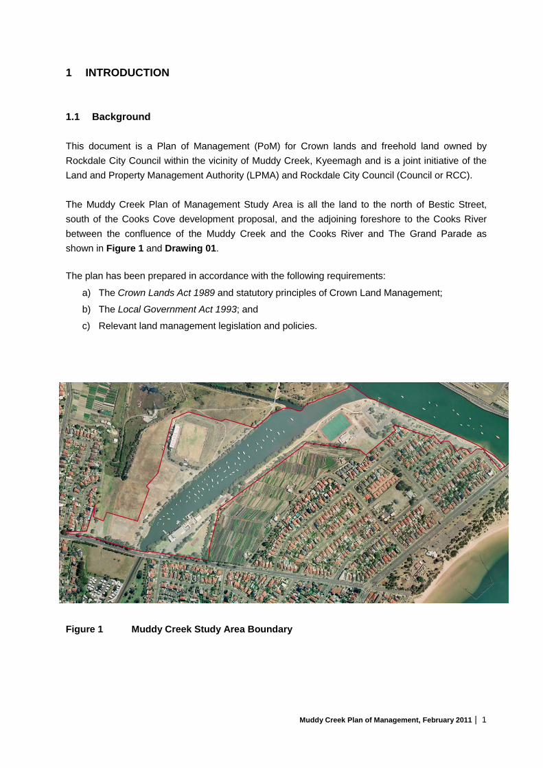
1 INTRODUCTION 1.1 Background This document is a Plan of Management (PoM) for Crown lands and freehold land owned by Rockdale City Council within the vicinity of Muddy Creek, Kyeemagh and is a joint initiative of the Land and Property Management Authority (LPMA) and Rockdale City Council (Council or RCC). The Muddy Creek Plan of Management Study Area is all the land to the north of Bestic Street, south of the Cooks Cove development proposal, and the adjoining foreshore to the Cooks River between the confluence of the Muddy Creek and the Cooks River and The Grand Parade as shown in Figure 1 and Drawing 01. The plan has been prepared in accordance with the following requirements:
a) The Crown Lands Act 1989 and statutory principles of Crown Land Management;
b) The Local Government Act 1993; and
c) Relevant land management legislation and policies.
Figure 1 Muddy Creek Study Area Boundary

Muddy Creek Plan of Management, February 2011 | 2
1.2 Purpose The purpose of this PoM is to provide a planning context and framework to facilitate identified development opportunities for recreation and related purposes within the Muddy Creek Study Area, and for the on-going management of the land asset in a sustainable manner. The planning emphasis is on optimising the land assets of both agencies and to provide a wide range of recreational facilities for the benefit of the community. The Plan of Management has no time limit, however, it should be formally reviewed five (5) years from the date of adoption, or sooner if circumstances warrant. 1.3 Land to Which this Plan of Management Applies Details of the land ownership of the public lands within the Muddy Creek Plan of Management Study Area are shown in Drawing 02 and described in Table 1. In total the Study Area covers approximately 24.2 hectares. Table 1 Land Description of Public lands in the Study Area Property Description Owner Name of Reservation 1 Lot A DP 400546 Rockdale City Council Unnamed 2 Public Road Rockdale City Council Unformed part of Eve Street 3 Part Lot 1 DP 576148 Rockdale City Council Barton Park 4 Part Lot 7303 DP
1148740 Crown land Barton Park R 62644 Reserved for Public
Recreation
5 Tidal land Crown land Crown Waterway 6 Lot 5 DP 17133 Rockdale City Council Lance Studdert Reserve 7 Lot 6 DP 17133 Rockdale City Council Kyeemagh Boat Ramp Reserve 8 Lot 2 DP 442212 Rockdale City Council 9 Part Lot 7 DP 1050923 Crown land Crown land (Pt Reserve R1011268) for
Future Public Requirements 10 Lot 5 DP 31742 Rockdale City Council Kyeemagh Boat Ramp Reserve 11 Lot 7 DP 31742 Rockdale City Council
1.4 Surrounding Land Uses The following land uses are found in the vicinity of the Muddy Creek PoM Study Area: Residential areas Residential areas are located to the west and east of the study area and the
south of Bestic Street.
Open Space The Kogarah Golf Club will be relocated to the open space area north of Bestic Street adjoining the St George Soccer Stadium – see section 1.5. RTA and the Department of Planning own land south of Bestic Street.

Muddy Creek Plan of Management, February 2011 | 3
Tidal waters The Cooks River which provides access to Botany Bay forms the northern boundary of the study area.
Sydney Airport Kingsford Smith Airport (KSA) is located on the northern side of the Cooks River. The operation of the airport impacts on activities in two main ways through controls on the height of buildings/structures and lighting.
Market gardens There are two market gardens in the vicinity of Muddy Creek, which are heritage items. Both on land owned by the Department of Planning.
Figure 2 Adopted Cooks Cove Master Plan

Muddy Creek Plan of Management, February 2011 | 4
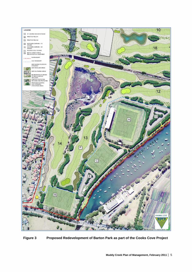
1.5 Cooks Cove Development Corporation The Cooks Cove Development Corporation (CCDC) was established in July 2001 under the Growth Centres (Development Corporations) Act 1974 to manage the development of the Cooks Cove site, which is a 100 hectare site, adjoining the Muddy Creek Plan of Management Study Area. The Sydney Harbour Foreshore Authority was appointed as the site’s managing agent in September 2001. A Master Plan, prepared for the site in 2004, distributes landuses within the Cooks Cove Development Area to capitalise on the proximity of the area to Kingsford Smith International Airport. The plan entails moving the Kogarah Golf Club from its current location adjoining Marsh Street to the southern portion of the Cooks Cove site. The proposed golf course will occupy part of Barton Park and the adjoining public open space as illustrated in Figure 2. The former golf course land adjoining Marsh Street is proposed to be developed as a major commercial precinct. Development manager, Boyd Cook Cove Pty Ltd (subsequently replaced in 2008 by Cooks Cove Pty Ltd) prepared a draft Plan of Management for the Crown lands within the Muddy Creek Plan of Management Study Area as part of its Development Application (DA PoM). The DA PoM as adopted by the Minister for Lands on the 14th October 2008. The implications of the DA PoM, which is illustrated in Figure 3, are as follows:
• The St George Soccer Stadium is retained in its current condition but not redeveloped; • Two soccer fields are redeveloped; • Two parking areas and an access road along Muddy Creek are provided; • Retention of a pedestrian access way along the western foreshore of Muddy Creek; • Provision of a pedestrian/cycleway bridge across Muddy Creek at the junction with Cooks
River; and • A park at the south end of the site at Bestic Street.
1.6 Kyeemagh Boat Ramp Reserve Plan of Management Council adopted a Plan of Management under the Local Government Act 1993 (LG Act) for the Kyeemagh Boat Ramp Reserve in December 20021. The area covered in the Kyeemagh Boat Ramp Reserve Plan of Management was all the Council owned land listed in Table 1. At the time the plan focused on the recreational boating activities of the Brighton–Le-Sands Amateur Fishermen’s Club and the proposed construction of a hockey field associated with the Kyeemagh RSL Club. The plan incorporated earlier work involving a Landscape Improvement Plan and a Design and Management Report2
. On adoption, the Muddy Creek Plan of Management will replace the Kyeemagh Boat Ramp Reserve Plan of Management, although the existing categorisation of the land has been retained and where appropriate many of the key strategies.
1 Kyeemagh Boat Ramp Reserve Plan of Management, JCa, December 2002. 2 Kyeemagh Reserve Design and Management Report, JCa, 2000.
Muddy Creek Plan of Management, February 2011 | 5
Figure 3 Proposed Redevelopment of Barton Park as part of the Cooks Cove Project

Muddy Creek Plan of Management, February 2011 | 6
2 PLANNING CONTEXT 2.1 Legislative and Planning Framework Land within the study area is subject to a wide array of controls found in legislation, statutory planning instruments, and plans and polices. The planning controls or requirements which are directly relevant to this PoM are discussed in this section and Appendix 1. 2.2 Crown Lands Act and Regulations The Crown Lands Act 1989 (CL Act) regulates the manner in which Crown land is dealt with (occupied, used, sold, leased, or licenced) or managed as dedicated or reserved Crown land. The Act empowers the Minister, in achieving the objects of the Act, to sell, lease, licence or reserve Crown land. As a general principle, not all Crown land is able to or should be sold and accordingly the Act provides for the creation and administration of Crown lands reserved for a public purpose. The use and management of Crown land must be in accordance with the provisions of the Crown Lands Act 1989. The principles of Crown land management have a legal basis in section 11 of the CL Act, and are listed in Appendix 1. The reserve management provisions of Part 5 of the CL Act contain the following broad powers which the Minister or the manager of a reserve may employ in implementing the principles of Crown land management:
• The Minister may reserve Crown land for future public requirements or other public purpose;
• The Minister may appoint a reserve trust to manage reserved or dedicated Crown land;
• The Minister, or a reserve trust with the approval of the Minister, may sell or create leases, licences, easements or mortgage reserved Crown land;
• The Minister may cause a draft plan of management to be prepared and following referral and exhibition may adopt a plan with or without modification; and
• The Governor may make by-laws with respect to a reserve, its use and management. Before adopting a Plan of Management of submerged Crown Land the Minister for Lands must consult in writing with the Minister for Fisheries and obtain the Minister’s concurrence to the proposed plan. The relevant concurrence was received on the 11th January 2011 (Appendix 2). The Crown land within the Muddy Creek Study Area is either Crown waterway or Crown land reserved for public recreation. The location of the areas of Crown land is shown in Drawing 02.
Muddy Creek Plan of Management, February 2011 | 7
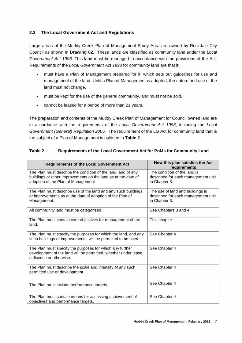
2.3 The Local Government Act and Regulations Large areas of the Muddy Creek Plan of Management Study Area are owned by Rockdale City Council as shown in Drawing 02. These lands are classified as community land under the Local Government Act 1993. This land must be managed in accordance with the provisions of the Act. Requirements of the Local Government Act 1993 for community land are that it:
• must have a Plan of Management prepared for it, which sets out guidelines for use and management of the land. Until a Plan of Management is adopted, the nature and use of the land must not change.
• must be kept for the use of the general community, and must not be sold.
• cannot be leased for a period of more than 21 years. The preparation and contents of the Muddy Creek Plan of Management for Council owned land are in accordance with the requirements of the Local Government Act 1993, including the Local Government (General) Regulation 2005. The requirement of the LG Act for community land that is the subject of a Plan of Management is outlined in Table 2. Table 2 Requirements of the Local Government Act for PoMs for Community Land
Requirements of the Local Government Act How this plan satisfies the Act requirements
The Plan must describe the condition of the land, and of any buildings or other improvements on the land as at the date of adoption of the Plan of Management
The condition of the land is described for each management unit in Chapter 3.
The Plan must describe use of the land and any such buildings or improvements as at the date of adoption of the Plan of Management.
The use of land and buildings is described for each management unit in Chapter 3.
All community land must be categorised.
See Chapters 3 and 4
The Plan must contain core objectives for management of the land.
This chapter
The Plan must specify the purposes for which the land, and any such buildings or improvements, will be permitted to be used.
See Chapter 4
The Plan must specify the purposes for which any further development of the land will be permitted, whether under lease or licence or otherwise.
See Chapter 4
The Plan must describe the scale and intensity of any such permitted use or development.
See Chapter 4
The Plan must include performance targets
See Chapter 4
The Plan must contain means for assessing achievement of objectives and performance targets.
See Chapter 4

Muddy Creek Plan of Management, February 2011 | 8
Under Section 36 of the LG Act, community land is required to be categorised as one or more of the following:
• Natural area (further categorised as either bushland, wetland, escarpment, watercourse or foreshore)
• Sportsground • Park • Area of cultural significance • General community use.
Consistent with the guidelines for categorising community land in the Local Government (General) Regulation 2005 and Section 36 (4) of the Local Government Act 1993, the community land within the Muddy Creek Plan of Management Study Area is proposed to be categorised as ‘Park’, ‘Sportsground’ and ‘General Community Use’ as discussed in Chapters 3 and 4. Community land must be managed in accordance with the core objectives for the relevant category. Core objectives for these categories are given in Table 3. The proposed categorisation of the land does not re-categorise the existing categories in the Kyeemagh Boat Ramp Reserve Plan of Management. Table 3 Core Objectives for Categories of Community Land adopted under this Plan Category Definition Core Objectives Park Land which is, or proposed to
be, improved by landscaping, gardens or the provision of non sporting equipment and facilities, and for uses which are mainly passive or active recreational, social, educational and cultural pursuits that not unduly intrude on the peaceful enjoyment of the land by others.
• encourage, promote and facilitate recreational, cultural, social and educational pastimes and activities.
• provide for passive recreational activities or
pastimes and for the casual playing of games. • improve the land in such a way as to promote and
facilitate its use to achieve the other core objectives for its management.
Sports Ground
As the land is used or proposed to be used primarily for active recreation involving organised sports or playing of outdoor games.
• encourage, promote and facilitate recreational pursuits in the community involving organised and informal sporting activities and games.
• ensure that such activities are managed having
regard to any adverse impact on surrounding or nearby residences.
General Community Use
Land that may be made available for use for any purpose for which community land may be used, whether by the public at large or by specific sections of the public.
• promote, encourage and provide for the use of the land, and to provide facilities on the land, to meet the current and future needs of the local community and of the wider public in relation to:
- public recreation and the physical, cultural, social and intellectual welfare or development of individual members of the public.
- purposes for which a lease, licence or other estate may be granted in respect of the land (other than the provision of public utilities and works associated with or ancillary to public utilities).

Muddy Creek Plan of Management, February 2011 | 9
2.4 Land Use Controls In addition to the statutory controls proposed in this PoM, land within the Study Area is subject to a number of statutory planning instruments. The principal planning instruments are the Rockdale Local Environmental Plan 2000 (RLEP), the Sydney Regional Environmental Plan – Cooks Cove, State Environmental Planning Policy (Major Projects) 2005, and State Environmental Planning Policy (infrastructure) 2007. 2.4.1 Rockdale Local Environmental Plan The Rockdale Local Environmental Plan 2000 (RLEP) controls development in the Rockdale local government area. Development must be consistent with the land use zone objectives and controls in RLEP. The lands are currently either unzoned (ie the bed of Muddy Creek) or zoned 6(a) Existing Open Space. Unzoned land is controlled within the Rockdale area by clause 17 of RLEP which provides that with certain exceptions such land may only be developed with development consent:
Unzoned land – Clause 17
Objective of the provision
To ensure that the development of unzoned land does not adversely impact on adjoining land uses.
(1) This clause applies to all land to which this plan applies that is shown not zoned on the map.
(2) Development shall not be carried out on land to which this clause applies except with development consent.
(3) In determining a development application required by this clause the consent authority must have regard to the objectives of any zone within which land abutting the unzoned land is situated.
(4) Notwithstanding subclause (2), consent is not required for development for the purpose of roads or utility installations (other than railway, water or air transport, wharf or river infrastructure, gas holders or generating works).
The objectives and land use controls (see Table 4) for the 6(a) zone are as follows:
Objectives of the RLEP 6(a) Zone:
(a) to identify public land owned or managed by the Council (or another public authority) and used or intended for use for open space and public recreational purposes, and
(b) to enable development of land for open space and recreational purposes, and
(c) to facilitate other ancillary or related purposes which will encourage the enjoyment of land zoned for local recreation.

Muddy Creek Plan of Management, February 2011 | 10
Table 4 Development Control Table for the 6(a) Existing Open Space Zone of RLEP
Development which does not require consent
Development which requires Consent
Prohibited Development
• bushfire hazard reduction,
• gardening and landscaping works.
• Exempt development
• agriculture; • beach and foreshore
restoration works; • buildings used for bushfire
hazard reduction, • child care centres; • drainage; • recreation areas; roads; • utility installations other than
gas holders or generating works.
Any development that is not allowed without or only with consent.
Permissible development in the 6(a) zone is shown in Table 5. In addition, minor works are permitted by RCC’s exempt and complying provisions which are subject to the provisions of clause 13 of RLEP.
2.4.2 Sydney Regional Environmental Plan No. 33 - Cooks Cove The Sydney Regional Environmental Plan No. 33 - Cooks Cove (SREP 33) provides the planning principles and controls for the Cooks Cove site which is essential for the area of the Muddy Creek Plan of Management Study Area north of Bestic Street and the eastern foreshore of Muddy Creek. Council is the consent authority for development within the Cooks Cove site apart from development that is subject to Part 3A of the Environmental Planning and Assessment Act 1979 (EP&A Act). Land within the Muddy Creek Plan of Management Study Area is zoned under SREP 33 as Open Space. The objectives of the Open Space zone are:
(a) to provide for active sporting and recreational land uses and club facilities, and
(b) to provide public access along the Cooks River and Muddy Creek foreshores, and
(c) to protect significant wetland areas within the Cooks Cove site and along the Cooks River foreshores, and
(d) to provide for facilities that are ancillary to the recreational use of public open space, and
(e) to provide vegetated riparian areas to enhance biological connectivity along the Cooks River and Muddy Creek foreshores, and
(f) to protect and enhance the habitat of the Green and Golden Bell Frog established within Cooks Cove.
In the Open Space zone the controls identified in Table 5 apply.

Muddy Creek Plan of Management, February 2011 | 11
Table 5 Development Control Table under SREPP 33
Development which does not require consent
Development which requires Consent Prohibited Development
aids to navigation; gardening; landscape maintenance works (including tree planting, repaving and replacement of street furniture); other maintenance works; public utility undertakings.
artworks; boat landing and hire facilities; boat ramps and berths; car parks; clubs; community facilities; drainage; identifying or interpretive signage ancillary to another use allowed on the site; kiosks; landscaping (except landscape maintenance works); outdoor eating areas (if linked to kiosks within the zone or restaurants in adjoining zones); recreation areas; recreation facilities; remediation of land; roads; other land uses incidental or ancillary to the land uses lawfully carried out within the zone at the commencement of this plan.
Any development that is not allowed without or only with consent.
Clause 20 of SREP 33 provides that prior to granting consent to any development within the Open Space zone the consent authority (Council) must consider a plan of management made under the provisions of the Crown Lands Act 1989. SREP 33 also contains a general development standard for building heights (5m if within 120m of the Cooks River).
2.4.3 State Environmental Planning Policy (Infrastructure) 2007 State Environmental Planning Policy (Infrastructure) 2007 provides that certain types of works do not require development consent despite the provisions of any other planning instruments. Clause 65 (2) 12 of the Policy provides in respect of land that is a reserve within the meaning of the Crown Lands Act 1989 development can be undertaken without consent by (or on behalf of) the Chief Executive of the Land and Property Management Authority, a trustee of the reserve, the Ministerial Land Corporation, or an administrator of the reserve if the development is for purposes of implementing a plan of management adopted for the land. Clause 65 (3) of the Policy states that development for any of the following purposes may be carried out by or on behalf of a council without consent on a public reserve under the care and control or vested in Council:
(a) roads, cycleways, single storey car parks, ticketing facilities and viewing platforms,
(b) outdoor recreational facilities, including playing fields, but not including grandstands,
(c) information facilities such as visitors’ centres and information boards,
(d) lighting, if light spill and artificial sky glow is minimised in accordance with AS/NZS 1158: 2007, Lighting for Roads and Public Spaces,
(e) landscaping, including irrigation schemes (whether they use recycled or other water),
(f) amenity facilities,
(g) maintenance depots,
(h) environmental management works.
Muddy Creek Plan of Management, February 2011 | 12
2.4.4 State Environmental Planning Policy (Major Projects) 2005 State Environmental Planning Policy (Major Projects) 2005 defines development that is subject to Part 3A of the EP&A Act because of its State environmental planning significance. Part 3A matters require the approval of the Minister for Planning. While the Muddy Creek Plan of Management Study Area is not defined in the Policy as a specific site, or a site of State significance, there is one type of development identified in Schedule 1 of the Policy that is potentially applicable:
14 Marina facilities (1) Development for the purpose of marinas or other related land or water shoreline facilities that
moor, berth or store vessels (excluding dinghies and other small craft) at fixed or floating berths, at freestanding moorings, alongside jetties or pontoons, within dry storage stacks or on cradles in hardstand areas and that:
(a) moor, berth or store more than 30 vessels in Sydney Harbour, Middle Harbour, North Harbour, Botany Bay, Port Hacking, Broken Bay or associated tidal waters (emphasis added).
2.5 Rockdale Open Space and Recreation Strategy An Open Space and Recreation Strategy has been prepared by Rockdale City Council as part of its strategic planning for the City of Rockdale3
. Council recognises that the quality of open space and the level of facility provision have a significant impact on people’s leisure and recreational opportunities. The strategy is based on an analysis of open space and recreation facility supply and identifies the current and future needs of the community and highlights future asset requirements. Within the City three major open space corridors were identified: The foreshore of Botany Bay (Cook Park); the Rockdale Wetlands Corridor – which includes the Muddy Creek Plan of Management Study Area; and the Bardwell Valley.
Council had previously identified Planning Precincts based on an analysis of suburbs within the City. The Muddy Creek Plan of Management Study Area is within the Brighton Planning Precinct. In terms of open space provision within the Brighton Precinct the assessment made an overall observation which is relevant to this Plan of Management:
While the Brighton Precinct is well supplied with regional and district open space, access to this open space is not ideal due to heavy traffic volumes along The Grand Parade and open space behind residential properties…… This highlights the need to improve access to the existing open space and provide functional quality neighbourhood and local open space where it exists.4
The Strategy identified six Priority Themes and desired outcomes. These themes and the specific actions identified for the Muddy Creek Plan of Management Study Area are shown in Table 6.
3 City of Rockdale, Open Space and Recreation Strategy, Suter Planners, February 2008. 4 City of Rockdale, Open Space and Recreation Strategy, Part 2 Strategy Background, Suter Planners, February
2008

Muddy Creek Plan of Management, February 2011 | 13
Table 6 Actions identified in the Rockdale Open Space and Recreation Strategy Priority Theme and Desired Outcome What needs to be done – Actions relevant to the Muddy
Creek Plan of Management Study Area 1. Adequate Provision of Open Space A good provision of open space that is accessible to the community, including unique recreation and sport destinations as well as neighbourhood and local provision.
• Ideally the F6 Corridor land should be retained as open
space. The design of any future freeway should aim to minimise the loss.
2. Open Space Quality and Function Open space that is of high value to the community due to its quality, appeal, safety and activity opportunities.
• Quality issues to be addressed include condition of
amenities, design and condition of shelters, seating and tables, and landscaping, adequacy of lighting, and pathway quality and provision.
3. Sports Development Opportunities A balance of sports opportunities achieved through appropriately located and developed facilities.
• The sportsgrounds receive a high level of use and most
are in need of upgrade. Strategies are required to upgrade and manage the use of sportsgrounds.
• Opportunities to establish some additional fields should
be considered to respond to: − The increasing population and demand for fields; − The loss of some fields due to the Cooks Cove
Development; − The potential loss of fields in the F6 is developed
over existing sporting open space. • Quality sports hubs should be established to provide a
focus for sport, rather than small sportsgrounds. • There is potential to redevelop the St George Sports
Stadium to a quality standard to cater for various sports at a high competition and spectator level. However, a complete rebuild may be required.
Specific Action: Investigate redeveloping the St George Sports Stadium as a significant multi-use facility with connections to adjoining open space and commercial facilities.
Muddy Creek Plan of Management, February 2011 | 14
Priority Theme and Desired Outcome What needs to be done – Actions relevant to the Muddy Creek Plan of Management Study Area
4. Recreation Destinations Quality and distinctive recreations that provide unique leisure and recreation opportunities for residents, visitors and workers.
• Commercial initiatives linked to recreation destinations
should be considered to enhance the leisure experience, e.g. cafes, markets, events.
Specific Actions
− consider cafes, restaurants, function facilities in the following reserves – Muddy Creek: restaurants and cafes along the creek alongside the Fishermen’s Club.
− Establish event and market places at key locations, giving consideration to the following: ∗ Lance Studdert Reserve: community activities
and events (including ‘growers and fish market’ to reflect the heritage of the area.
∗ St George Sports Stadium: key event venue (community and cultural as well as sport)
∗ Land opposite Barton Park on Bestic Street: possible car parking to support suggested Muddy Creek Precinct.
− Investigate establishing accommodation near Barton Park and the suggested restaurant and café precinct along Muddy Creek.
5. Natural Areas and the Environment Protected, enhanced and appropriately managed natural areas, and a general commitment to best practice and the environment.
Most of the land within the Muddy Creek PoM is not in its natural state and not suitable for categorisation as a ‘natural area’, however, the following is pertinent: • There is potential to enhance the quality of remnant
vegetation and bio-diversity. • There is a need to protect natural areas from becoming
‘squeezed out’ by other development.
6. Indoor Sport and Aquatic Facilities Indoor Sport, leisure and aquatic facilities that support a range of activities and groups in the community and are high quality, strategically located and viable.
There is potential for such facilities to be developed as commercial adjuncts to large development and activities associated with the redevelopment of the St George Stadium.

Muddy Creek Plan of Management, February 2011 | 15
2.6 Native Title The Commonwealth Native Title legislation in 1993 recognised the existence of native title and made provision for Aboriginal and Torres Strait Islanders to lodge claims over Crown land. The legislation also sets out the requirements for the Crown and appointed Crown reserve trusts in dealing with Crown land unless it can be clearly established that any native title rights and interests that may have existed have been extinguished. Native title may have been extinguished over parts or the whole of the Crown lands in and adjoining Muddy Creek by the construction of authorised public works or by the lawful use of the land that is wholly inconsistent with the continuation of native title rights and interests. It will be the responsibility of the reserve managers to ensure that prior to any works being undertaken, the issue of native title is addressed. 2.7 Climate Change and Floodplain Risk Guidelines The Department of Environment, Climate Change and Water (DECC& W) released guidelines5 on incorporating sea level rise into flood risk and coastal hazard assessment in August 2010. The Department of Environment and Planning (DoP) has also released guidelines6
on incorporating sea level rise in land-use planning and development. The purpose of these Guidelines is to provide advice to assist in considering climate change in managing flood risk. Climate change is expected to have adverse impacts upon sea levels and rain fall intensities, both of which may have significant influence on flood behaviour at specific locations. In particular, sea level rise for the NSW Coast may be between 0.18 and 0.91m by 2100; larger scale rainstorms are also expected to increase.
While the trends identified in the Guidelines relate to long-term events, parts of the Muddy Creek Plan of Management Study Area are subject to flooding and accordingly the reserve trust manager, and lessees will be responsible to monitor and incorporate the recommendations of the DECC&W and DoP.
5 Flood Risk Management Guide and Coastal Risk Management Guide, Department of Environment,
Climate Change and Water, August 2010. 6 NSW Coast Planning Guideline: Adapting to Sea Level Rise, Department of Planning, 2010.

Muddy Creek Plan of Management, February 2011 | 16
3 MANAGEMENT PRECINCTS 3.1 Introduction The Muddy Creek Plan of Management Study Area provides a range of recreational opportunities – both active and passive. Included within the area are playing fields and a disused stadium, two registered clubs, boat launching ramps, swing moorings and associated parking, community facilities, pedestrian/cycleway, and areas of park. Central to the whole area is Muddy Creek, which is a tributary of the Cooks River, and its foreshores. An analysis of the condition of the land, management issues and opportunities is contained in Drawing 03. The PoM provides an opportunity to achieve the following key outcomes:
• A reconfiguration of the balance of Barton Park as a result of the Cook Cove Redevelopment;
• Redevelopment of the former St George Soccer Stadium to capitalise on its location and to achieve the intent of Rockdale Council’s Open Space Strategy;
• A reconfiguration of the current boating activities in Muddy Creek and on its foreshores through the development of a marina and to improve water quality;
• Opportunities of additional commercial recreational facilities to service the community; • Provide further opportunities for the existing clubs and associations to meet community
objectives; and • To maintain and enhance community access to the foreshore subject to maintaining the
existing mangroves located on both banks of Muddy Creek. 3.2 Management Issues and Opportunities The Muddy Creek Plan of Management Study Area is a large area of open space that provides an extensive range of passive and active recreation activities for residents in the locality and from the larger inner city region. Drawing 03 contains a summary of the key management issues, constrains and opportunities. Regard has been given to the needs of current stakeholders (users, leases/licensees etc) and to the requirements identified in the Rockdale Open Space and Recreation Strategy. The key constraints and opportunities addressed in this plan are:
Constraints • Traffic volumes on Bestic Street • Areas available for parking • RTAs future requirements for the F6 Corridor • Condition of the former St George Soccer Stadium • The boundary west of Muddy creek defined by the land committed to the Cooks Cove
Redevelopment. • Land contamination • Potential flooding impacts • Height and lighting constraints from KSA operational requirements.
Opportunities • New regional scale recreational facilities – for athletics and soccer, and recreational fishing • Recreationally focused commercial activities
Muddy Creek Plan of Management, February 2011 | 17
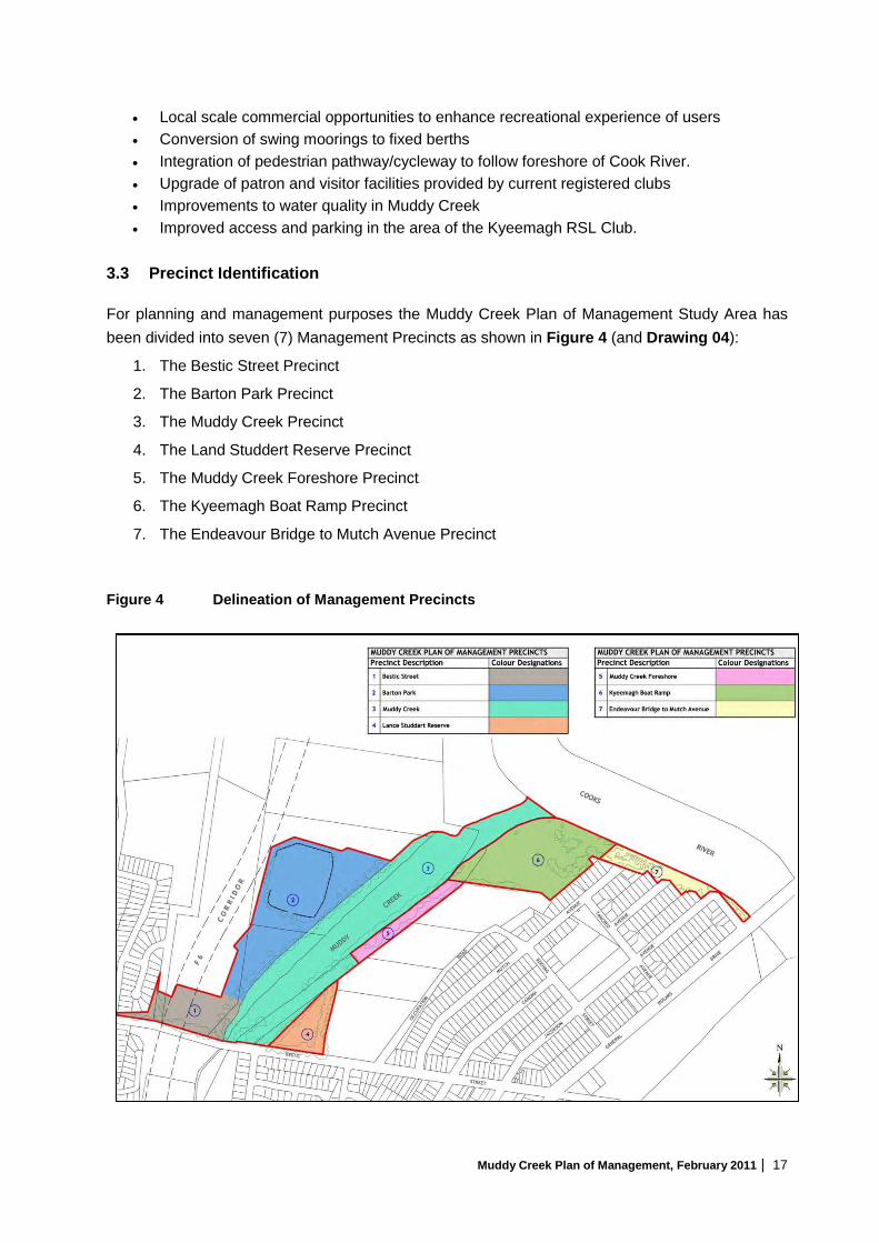
• Local scale commercial opportunities to enhance recreational experience of users • Conversion of swing moorings to fixed berths • Integration of pedestrian pathway/cycleway to follow foreshore of Cook River. • Upgrade of patron and visitor facilities provided by current registered clubs • Improvements to water quality in Muddy Creek • Improved access and parking in the area of the Kyeemagh RSL Club.
3.3 Precinct Identification For planning and management purposes the Muddy Creek Plan of Management Study Area has been divided into seven (7) Management Precincts as shown in Figure 4 (and Drawing 04):
1. The Bestic Street Precinct
2. The Barton Park Precinct
3. The Muddy Creek Precinct
4. The Land Studdert Reserve Precinct
5. The Muddy Creek Foreshore Precinct
6. The Kyeemagh Boat Ramp Precinct
7. The Endeavour Bridge to Mutch Avenue Precinct Figure 4 Delineation of Management Precincts

Muddy Creek Plan of Management, February 2011 | 18
A description of each Precinct, the condition of the land, management issues and development opportunities are discussed in this section. The boundaries are based on a consideration of landform, landownership, environmental factors, and current and future use. Consideration of Management Objectives and Strategies for each precinct is presented in Section 4 of this PoM. 3.4 Bestic Street Precinct Land Description: Lot A DP400546, Public Road, Parts of Lot 1 DP 576148
and Part Lot 7303 DP 1148740 Comprising Council and Crown land
Area: Approximately 20,000 m2 Categorisation Park This Precinct includes the land bounded by Bestic Street, Muddy Creek, the Cooks Cove development area to the north and residential land to the west. The shape of the precinct is determined by the land required to accommodate the relocation of the Kogarah Golf Club as part of the Cooks Cove Development. The central area of this management unit has been shaped by former land filling to create the existing playing field. The resulting land surface is impacted by intensive recreation use. The thick vegetation which fringes the frontage to Bestic Street is at a lower level to the playing field to the north and is a significant contributor to the visual amenity of the southern boundary to Barton Park.

Muddy Creek Plan of Management, February 2011 | 19
The location of the F6 Corridor within the Precinct limits current and future use of the land. RTA has indicated that there should be not built structures within the F6 Corridor because this would prejudice future decisions about the corridor. At present the land acts as the gateway to Barton Park via vehicular access from Bestic Street. It contains one soccer field and car parking. The frontage to Bestic Street is heavily landscaped with views of the boats moored in Muddy Creek and the ‘working face’ of the Fishermen’s Club. Following the Cooks Cove Development of the adjoining lands this Precinct is suitable for a Park with supporting commercial services such as outdoor kiosk. Provision could also be made for a pedestrian link across Muddy Creek.
3.5 Barton Park Precinct
Land Description: Parts of Lot 7303 DP 1148740 – Crown land Area: Approximately 57,720 m2 Categorisation Sports Ground The dominant feature of this Precinct, which is part of Barton Park, is the derelict former St George Soccer Stadium. The playing surface has been maintained. The grandstand and support infrastructure, however, may now be beyond repair. An access way along Muddy Creek, which is only partially sealed, currently provides pedestrian and bicycle access between Bestic Street and areas to the north of the drainage channel at the northern end of Barton Park. The Precinct also contains parts of soccer fields, an amenity block and some unformed parking areas that are in poor condition. The mangroves bordering the foreshore provide an effective visual screen to the boats moored in Muddy Creek.

Muddy Creek Plan of Management, February 2011 | 20
The elevated area of the Precinct is essentially flood free and suitable for development for a range of recreation based activities. The only significant development constrains are access, issues associated with land contamination from prior land filling activities, and height/lighting restrictions due to proximity to Sydney Airport Under the current plan it is proposed that the existing grandstand and other built elements would be demolished. The removal of derelict structures will allow the playing surface to be maintained and used for a variety of sports until a final decision is taken on the use or further development of this area for major recreation and related commercial purposes. Parking and access in the short-term will be provided under the Cooks Cove redevelopment proposal. Potential development of the site could include a regional multi-purpose stadium to replace the existing facility. These features have a relatively large foot print – typically 200m by 150m – and require a significant amount of parking. This type of development would also stimulate the development of ancillary commercial development for education, training, and additional sporting and recreation facilities in the adjoining area. However, while this PoM does not propose such a facility, there would be a loss of at least one of the adjoining soccer fields. Consideration should also be given to formalising the parking areas, the amenities provided and improved landscaping. Alternatively the site could be devoted to a commercial development based on recreation and allied forms of commercial development. Given the level of parking that would be required to properly service a major sporting facility, additional parking would be required. Preliminary discussions with the RTA indicate that use of its land south of Bestic Street for overflow parking as an interim arrangement is possible but would require a formal arrangement. Traffic management controls on Bestic Street should also be considered in any development proposal. There is significant mangrove vegetation adjacent to both banks of Muddy Creek. Any activity in this region with the potential to harm the mangroves will require a permit under Section 205 of the Fisheries Management Act 1994. In order to facilitate the redevelopment of land in this Precinct, and to ensure that development and access is integrated with development in the Muddy Creek Precinct, consideration should be given to the preparation of a Master Plan which covers both Precincts before action is taken to call expressions of interest for the development in these Precincts. The Master Plan should also have regard to the redevelopment of the adjoining area of Cooks Cove.

Muddy Creek Plan of Management, February 2011 | 21
3.6 Muddy Creek Precinct Land Description: Crown waterway, Part Lot 7303 DP 1148740, Parts of Lot 5 and Lot 6
DP 17133, Part Lot 7 DP 1050923, comprising Crown land and Council Community Land
Area: Approximately 91,100 m2 Categorisation General Community Use and Park Muddy Creek precinct contains all the tidal waters of Muddy Creek, the adjoining foreshore owned by Council and leased to the Brighton Le-Sands Amateur Fishermans Club, and a Sea Scouts of NSW training facility. The tidal waters are popular for recreational fishing, particularly at the junction of Muddy Creek and the Cooks River, near the western side of Muddy Creek at the junction of Spring Canal, opposite the Amateur Fishermans Club, and the foreshore area of the Kyeemagh Boat Ramp Reserve. The Brighton Le-Sands Amateur Fishermans Club has been operating for nearly forty years and has some 3,000 members. It is a key public leisure facility and destination in its own right. The club holds a licence from NSW Maritime for all the swing moorings (80) in Muddy Creek. Access to the Club and its parking area is via a roundabout off Bestic Street. The existing vegetation plays a critical role in screening the parking and back of house areas from general public view. However, the current configuration of the facility has the following problems, which are recognised by the Club:
• Ad hoc additions have has an adverse impact on overall functionality of internal spaces;
• Lack of parking;
• The design of the restaurant area is inefficient;
• Foreshore area to Muddy Creek is not well presented and underutilised. In particular there is no provision for public access to the foreshore; and
• The boat servicing area and slipway lack adequate water quality measures. A significant opportunity exists to allow the Club to upgrade its current facilities through a major redevelopment of the Club’s premises. A key element is a proposal by the Club to replace the existing swing moorings with fixed berths. A possible configuration is shown in Figure 5. The benefits include an increase in the number of moorings, the installation of water quality measures, and activation of the foreshore to encourage pedestrians to move around the Club’s premises. In order to facilitate this initiative a lease longer than 21 years would be required because of the capital investment involved. Development approval would also be required under Part 3A of the EP & A Act because marinas are a schedule use under the provision of Schedule 1 of the SEPP (Major Projects) 2005. Any removal of mangroves will require a permit under section 205 of the Fisheries Management Act 1994.

Muddy Creek Plan of Management, February 2011 | 22
Muddy Creek Precinct Figure 5 Possible Marina Configuration

Muddy Creek Plan of Management, February 2011 | 23
Controls will also be required to ensure that the following matters area adequately addressed:
− Existing stakeholders’ requirements such as the Sea Scouts are addressed
− Public access to the foreshore is provided;
− Strict limits are placed on the number of berths (150);
− The amount of trailer parking is limited and properly designed;
− Existing vegetation on the foreshore of Muddy Creek to be protected; and
− Undue pressure must not be placed on the open space values of the adjoining Lance Studdert Reserve.
As noted previously, in order to facilitate the redevelopment of this Precinct and its integration with the Barton Park Precinct, consideration should be given to the preparation of a Master Plan covering both Precincts. Any proposed marina development will need to consider the Department of Industry and Investment’s Policy and Guidelines for Aquatic Habitat Management and Fish Conservation (1999).
3.7 Lance Studdert Reserve Precinct
Land Description: Part Lot 5 DP 17133 Community Land Area: Approximately 11,635 m2 Categorisation Park

Muddy Creek Plan of Management, February 2011 | 24
This triangular shaped Precinct contains the separately named Lance Studdert Reserve. This area widens out from the embankment and extends through to a frontage of approximately 100m at Bestic Street. Pedestrian, cycle and vehicular access is provided along the vegetated western edge of the Precinct. The Precinct contains an open grassed area, children’s play equipment, footpath/cycleway and a tree lined tidal drainage ditch on the eastern boundary of the reserve. This Park does not have particular visual qualities and its use is incidental to the activities of the Fishermen’s Club and passing cyclists with children. A pedestrian crossing would encourage greater use from the residential area to the south of Bestic Street. The Precinct is suitable for small-scale community events.
3.8 Muddy Creek Foreshore Precinct
Land Description: Part Lot 6 DP 17133 Community land Area: 8,952 m2 Categorisation Park The Muddy Creek Foreshore Precinct provides a natural foreshore link between the Brighton-Le-Sands Amateur Fishermans Club and the Kyeemagh RSL Club and boat ramp. The precinct separates Muddy Creek from the adjoining Chinese Gardens and is bisected by a pedestrian cycleway. The mangroves within the Muddy Creek Precinct visually isolate this Precinct from the waterway and the Stadium on the opposite bank of Muddy Creek.

Muddy Creek Plan of Management, February 2011 | 25
Action is required to improve lighting and to maintain and improve the cycleway and vegetation on the margins of the Precinct. No further development is envisaged within this precinct. The southern boundary defines the limit of vehicular access to the Muddy Creek foreshore.
3.9 Kyeemagh Boat Ramp Precinct Land Description: Part Lot 5 DP 31742 and Lot 2 DP 442212
Community land Area: 41,258 m2 Categorisation General Community Use, Park and Sportsground This Precinct is located at the confluence of the Cooks River and Muddy Creek and has been previously managed under the Kyeemagh Boat Ramp Reserve Plan of Management (December 2002). It contains significant recreational and community assets:
• Kyeemagh RSL Club, Hockey Field and associated car parking area;
• Kyeemagh Boat launching ramp, jetty and pontoon, and a trailer parking area; This boat ramp is the second most popular facility in the southern metropolitan area for access to Botany Bay;
• A small sandy foreshore to the Cooks River;
• Public toilet, cycleway, landscaped areas and children’s play area;
• Sydney Water Compound; and
• The route of the Sydney Desalination Pipeline goes under this precinct on the alignment of Tancred Avenue.

Muddy Creek Plan of Management, February 2011 | 26
Informal access to/from Tancred Avenue to the RSL Club and the adjoining parking area is via RTA owned land. Access to the car parking and trailer parking and the boat ramp is via Mutch Avenue. A substantial upgrade in the design of the parking and landscaping is also required. Rockdale City Council has prepared a redesign of the Kyeemagh Boat Ramp Reserve which, when implemented, will achieve a range of positive outcomes including:
• A single access point from Tancred Avenue to the RSL Club and the boat launching ramp and associated parking areas;
• Improved arrangements for car and trailer parking;
• Closure of the Mutch Avenue Access Point to other than service vehicles;
• Separation of the cycleway path from the parking areas; and
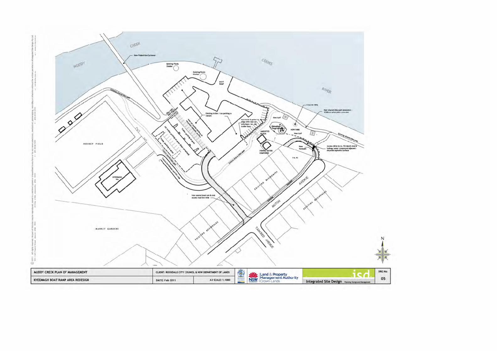
• Improved landscaping and play equipment and other recreation facilities. NSW Maritime has advised that under the relevant Australian Standards (AS3962-2001) Guidelines for the design of marinas, the recommended number of car/trailer spaces should be 40/50 per lane. The Kyeemagh boat ramp is a 3-4 lane boat ramp and therefore the provision should be 120 car/trailer spaces. NSW Maritime has requested that any redesign of the facility should not reduce but increase the available car/trailer spaces. Accordingly, it is proposed that MSW Maritime be consulted in the design of the Kyeemagh boat ramp facility. The formal road link into the Precinct to allow the closure of the Mutch Avenue access will require the agreement of the RTA. The design of the parking layout must also incorporate the approaches to a pedestrian/cycleway crossing of Muddy Creek which will be provided as part of the Cooks Cove redevelopment. A preliminary design of a bridge and its surrounds is shown in Figure 6. A long approach to the bridge is required to provide adequate clearance for boats to enter and leave Muddy Creek and to provide a suitable grade for disabled access.
Figure 67
Indicative Section of Bridge Access.
Figure 7 (and Drawing 05) show RCC’s design modified to incorporate the pedestrian/cycleway crossing of Muddy Creek. The design shown in Drawing 05 is indicative and subject to further refinement. The Muddy Creek PoM envisages that leases and licences required supporting existing sporting, recreational and community uses will be maintained in the short-term, however, their on-going requirement should be reviewed during the course of this Plan. 7 Base Drawing provided by Cooks Cove Pty Ltd,

Muddy Creek Plan of Management, February 2011 | 27
Figure 7 Proposed Improvements to the Access, Parking and Landscaping in the Kyeemagh Boat Ramp Precinct

Muddy Creek Plan of Management, February 2011 | 28
3.10 Endeavour Bridge to Mutch Avenue Precinct Land Description: Part Lot 5 DP 31742 and Lot 7 DP 31742
Community land Area: 11,079m2 Categorisation Park This Precinct is a narrow foreshore corridor along Cooks River from Endeavour Bridge to just beyond Mutch Avenue. It has a footpath/cycleway along its length, several large areas of green space and parking areas. Access to this Precinct is from Mutch, Owen, and Jacobson Avenues. The landscaping is characterised by scattered trees and mixed native plantings with the more mature trees located adjacent to the residential property boundaries. Adjacent to Owen Street is a small children’s play area. The Precinct also has two picnic shelters. This Precinct has the character of a neighbourhood park although it has wider appeal as part of the regional open space system. Management actions need to recognise its foreshore character. In the longer term, the provision of vehicular access to the boat ramp and associated parking areas from Tancred Avenue will allow the existing through access to the boat ramp and trailer parking areas from Mutch Street to be closed as shown in Drawing 05.

Muddy Creek Plan of Management, February 2011 | 29
4 MANAGEMENT FRAMEWORK 4.1 Overview The regional significance of the Muddy Creek area, and the scale of the potential development opportunities, requires a partnership between Rockdale City Council and the Land and Property Management Authority. The involvement of other government agencies such as the Cooks Cove Redevelopment Authority, Sydney Water, RTA, and the Department of Planning is also essential to drive the implementation process and on-going management. NSW Government procurement policy and guidelines provide an established framework by which new commercial development opportunities will be pursued in keeping with the objectives and strategies listed in this PoM. The overall goal is to encourage development that is self funding. Where public recreation facilities of a community nature are provided these may be funded by a mixture of state and private sector funding. 4.2 Management Strategies Objectives and strategies for future management by Council and LPMA in their respective roles should seek to deliver a range of key outcomes through a set of strategies for each precinct. For each Precinct, the ‘values’ of the land is given; where the land is classified as Community land the land has been categorised in accordance with the requirements of the LG Act. Where Crown land is involved the management principles of the CL Act are provided. This PoM provides the basis for the management for each Precinct:
• Values
• Categorisation (LG Act) or Management Principle (CL Act);
• Objectives
• Dealings
• Strategies/Actions to achieve the Objectives
• An indication of the priority of the Strategy/Action
• Responsibility
• Performance Measure The following abbreviations have been used in relation to specified responsibilities: CC Cook Cove Pty Ltd Lessee Existing or future lessee NSWM NSW Maritime RTA Roads and Traffic Authority
Planning NSW Department of Planning RCC Rockdale City Council LPMA Land and Property Management Authority
Muddy Creek Plan of Management, February 2011 | 30
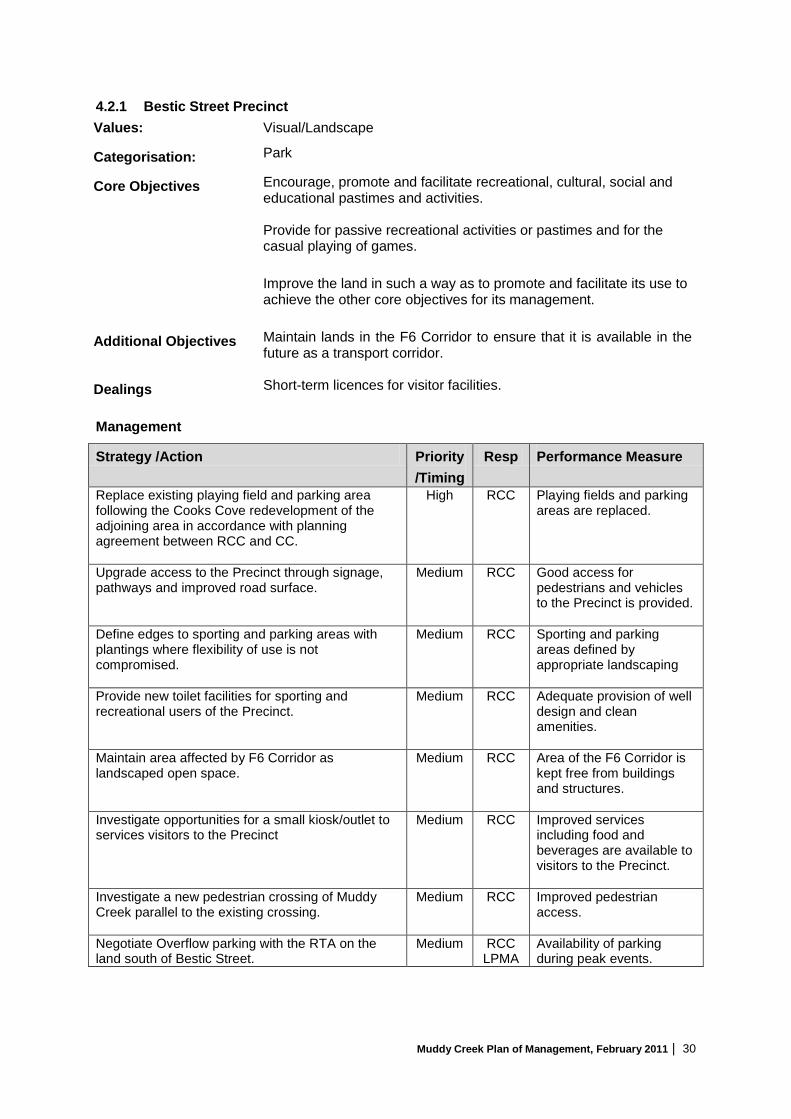
4.2.1 Bestic Street Precinct Values: Visual/Landscape
Categorisation: Park
Core Objectives Encourage, promote and facilitate recreational, cultural, social and educational pastimes and activities.
Provide for passive recreational activities or pastimes and for the casual playing of games.
Improve the land in such a way as to promote and facilitate its use to achieve the other core objectives for its management.
Additional Objectives Maintain lands in the F6 Corridor to ensure that it is available in the
future as a transport corridor.
Dealings Short-term licences for visitor facilities.
Management
Strategy /Action Priority /Timing
Resp Performance Measure
Replace existing playing field and parking area following the Cooks Cove redevelopment of the adjoining area in accordance with planning agreement between RCC and CC.
High RCC
Playing fields and parking areas are replaced.
Upgrade access to the Precinct through signage, pathways and improved road surface.
Medium RCC Good access for pedestrians and vehicles to the Precinct is provided.
Define edges to sporting and parking areas with plantings where flexibility of use is not compromised.
Medium RCC Sporting and parking areas defined by appropriate landscaping
Provide new toilet facilities for sporting and recreational users of the Precinct.
Medium RCC Adequate provision of well design and clean amenities.
Maintain area affected by F6 Corridor as landscaped open space.
Medium RCC Area of the F6 Corridor is kept free from buildings and structures.
Investigate opportunities for a small kiosk/outlet to services visitors to the Precinct
Medium RCC Improved services including food and beverages are available to visitors to the Precinct.
Investigate a new pedestrian crossing of Muddy Creek parallel to the existing crossing.
Medium RCC Improved pedestrian access.
Negotiate Overflow parking with the RTA on the land south of Bestic Street.
Medium RCC LPMA
Availability of parking during peak events.

Muddy Creek Plan of Management, February 2011 | 31
4.2.2 Barton Park Precinct Values: Recreation/visual
Categorisation: Sportsground
Core Objectives Encourage, promote and facilitate recreational pursuits in the community involving organised and informal sporting activities and games. Ensure that such activities are managed having regard to any adverse impact on surrounding or nearby residences.
Additional Objectives Encourage commercial development within the Precinct focused on recreation, leisure and lifestyle to capitalise on the key locational attributes of the former stadium site.
Dealings Long-term commercial leases to enable the development of recreation, sporting and recreation facilities and associated commercial uses; licences for the use of the land for recreation, leisure and lifestyle activities.
Management
Strategy /Action Priority /Timing
Resp Performance Measure
Prepare a Masterplan for the Precinct and the adjoining Muddy Creek Precinct to show how the purposes envisaged under this plan of management for mangrove management, recreation, sporting and commercial uses including the marina will be integrated.
High LPMA RCC
Completion of Master Plan.
Demolish existing grandstand and redundant buildings/structures associated with the former stadium.
High RCC Derelict buildings and structures removed.
Replace existing playing field and parking area following the Cooks Cover redevelopment of the adjoining area.
High CC Playing fields and parking areas are replaced.
Call expressions of interest for the development and lease of this key site for commercial purposes associated with recreation, leisure and lifestyle activities illustrated in the Masterplan for the Barton Park and Muddy Creek Precincts.
Medium LPMA RCC
Development of the site for commercial purposes consistent with the objectives for this Precinct.
Monitor level of parking, condition and general use of area.
Medium RCC Clean well kept area.
Muddy Creek Plan of Management, February 2011 | 32
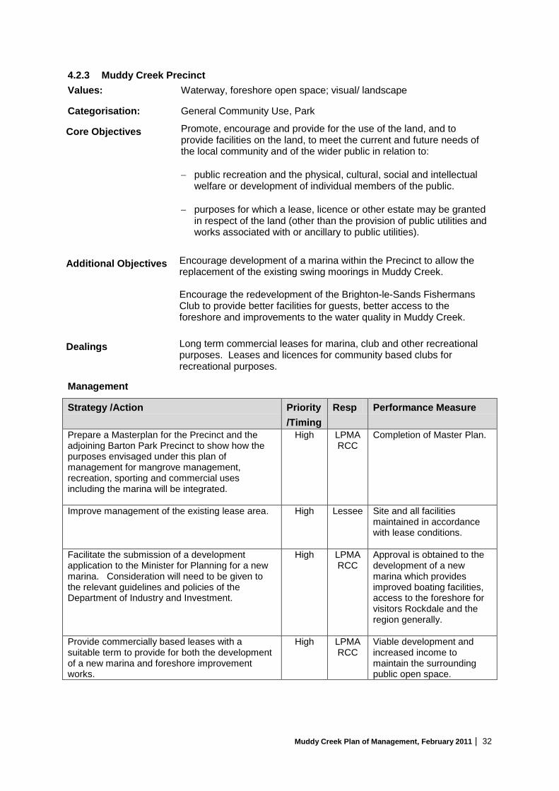
4.2.3 Muddy Creek Precinct Values: Waterway, foreshore open space; visual/ landscape
Categorisation: General Community Use, Park
Core Objectives Promote, encourage and provide for the use of the land, and to provide facilities on the land, to meet the current and future needs of the local community and of the wider public in relation to: − public recreation and the physical, cultural, social and intellectual
welfare or development of individual members of the public. − purposes for which a lease, licence or other estate may be granted
in respect of the land (other than the provision of public utilities and works associated with or ancillary to public utilities).
Additional Objectives Encourage development of a marina within the Precinct to allow the replacement of the existing swing moorings in Muddy Creek. Encourage the redevelopment of the Brighton-le-Sands Fishermans Club to provide better facilities for guests, better access to the foreshore and improvements to the water quality in Muddy Creek.
Dealings Long term commercial leases for marina, club and other recreational purposes. Leases and licences for community based clubs for recreational purposes.
Management
Strategy /Action Priority /Timing
Resp Performance Measure
Prepare a Masterplan for the Precinct and the adjoining Barton Park Precinct to show how the purposes envisaged under this plan of management for mangrove management, recreation, sporting and commercial uses including the marina will be integrated.
High LPMA RCC
Completion of Master Plan.
Improve management of the existing lease area. High Lessee Site and all facilities maintained in accordance with lease conditions.
Facilitate the submission of a development application to the Minister for Planning for a new marina. Consideration will need to be given to the relevant guidelines and policies of the Department of Industry and Investment.
High LPMA RCC
Approval is obtained to the development of a new marina which provides improved boating facilities, access to the foreshore for visitors Rockdale and the region generally.
Provide commercially based leases with a suitable term to provide for both the development of a new marina and foreshore improvement works.
High LPMA RCC
Viable development and increased income to maintain the surrounding public open space.

Muddy Creek Plan of Management, February 2011 | 33
4.2.4 Lance Studdert Reserve Precinct Values: Foreshore open space; Visual/ Landscape
Categorisation: Park
Core Objectives Encourage, promote and facilitate recreational, cultural, social and educational pastimes and activities. Provide for passive recreational activities or pastimes and for the casual playing of games. Improve the land in such a way as to promote and facilitate its use to achieve the other core objectives for its management.
Dealings Licences for recreational based activities.
Management
Strategy /Action Priority /Timing
Resp Performance Measure
Provision/review of lighting along cycle/pedestrian route, in gathering areas and car parks.
Medium RCC All key gathering and movement areas are adequately illuminated to ensure safety and security of Reserve users.
Remaining weeds to be removed by qualified Bushland regenerator.
Medium RCC Weed elimination.
A monitoring program to be set up to ensure that weed regrowth is contained.
Medium RCC Weed elimination.
Maintain small scale open space area suitable for children’s ball games and public use.
High RCC The use of the reserve by children and public generally.
Department of Planning to be approached to ensure market garden operators maintain appropriate clean water standards and agricultural practice to prevent the migration of nutrients to Muddy Creek.
Short term
RCC Elimination the presence of nutrients/pesticide leachates in Muddy Creek.
Prepare and implement a landscape plan to establish a more natural drainage line, establish appropriate planting and management regime.
Medium RCC PoM implemented and more natural drainage line established.

Muddy Creek Plan of Management, February 2011 | 34
4.2.5 Muddy Creek Foreshore Precinct Values: Foreshore open space; Recreation, Visual/ Landscape
Categorisation: Park
Core Objectives To maintain the foreshore as a transition area between the aquatic and the terrestrial environment, and to protect and enhance all functions associated with the foreshore’s role as a transition area.
To facilitate the ecologically sustainable use of the foreshore, and to mitigate impact on the foreshore by community use.
Dealings Nil
Management:
Strategy /Action Priority /Timing
Resp Performance Measure
Provision/review of lighting along cycle/pedestrian route.
Medium RCC Pedestrian/Cycleway adequately illuminated to ensure safety and security of users.
Remaining weeds on Muddy Creek embankment to be removed by qualified Bushland regenerator.
Medium RCC Weed elimination.
A monitoring program to be set up to ensure that weed regrowth is contained.
Medium RCC Weed elimination.
Observation platform and interpretative panel overlooking the Market Gardens.
Medium Planning/ RCC
Installed

Muddy Creek Plan of Management, February 2011 | 35
4.2.6 Kyeemagh Boat Ramp Precinct Values Foreshore open space; Sporting/Recreation Facilities
Categorisation General Community Use, park and sportsground.
Core Objectives Promote, encourage and provide for the use of the land, and to provide facilities on the land, to meet the current and future needs of the local community and of the wider public in relation to: − public recreation and the physical, cultural, social and
intellectual welfare or development of individuals of the public. − purposes for which a lease, licence or other estate may be
granted in respect of the land (other than the provision of public utilities and works associated with or ancillary to public utilities).
Additional Objectives Provision of integrated access for pedestrians/cyclists/cars and boats
to the Precinct.
Dealings Long term leases for the development of commercial purposes allied to public recreation.
Management:
Strategy /Action Priority /Timing
Resp Performance Measure
Assess the requirement for lease and licenses of the Kyeemagh RSL Club and Hockey Field.
High RCC Creation of a suitable commercially based tenure that provides improved public access and use of the facility.
Ensure that lease licence areas are properly maintained.
High Lessees Licensees
Complaints received.
Redesign and approve any necessary consents for the car parking area to provide:
• a single car park that services all users of this area of the reserve;
• A high level of amenity through the provision of landscaping; and
• Integration of the existing pedestrian cycleway crossing of Muddy Creek.
Redesign of trailer parking should be undertaken in consultation with NSWM.
High RCC NSWM
Approvals obtained and works completed.
Installation of Pedestrian/Cycleway crossing of Muddy Creek
High CCC Approach to crossing integrated with redesigned parking area.
Provide well-designed directional signage and maps that show the overall route of the cycleway and facilities.
Medium RCC Provision of signage and maps.
Provide signs and structures to ensure parking (cars and trailers) is limited to dedicated parking areas.
Medium RCC NSWM
No parking in unauthorised areas.
Random surveillance of the parking areas to identify unauthorised parking, rubbish build-up, and damage to landscaped areas.
High RCC Record of surveillance undertaken. Damage to landscaping repaired.

Muddy Creek Plan of Management, February 2011 | 36
4.2.7 Endeavour Bridge to Mutch Avenue Precinct Values: Foreshore open space; Visual/ Landscape
Categorisation: Park
Core Objectives Encourage, promote and facilitate recreational, cultural, social and educational pastimes and activities. Provide for passive recreational activities or pastimes and for the casual playing of games. Improve the land in such a way as to promote and facilitate its use to achieve the other core objectives for its management.
Dealings Nil
Management
Strategy /Action Priority /Timing
Resp. Performance Measure
Investigate the closure of Mutch Avenue to vehicular traffic to create more green space.
Medium RCC Greater use of this precinct.
Rebuild the cul-de-sac ends, replace traditional kerb and guttering with Sustainable Urban Drainage to minimise stormwater flow, and improve water quality of Cooks River.
Medium RCC Reduction of stormwater flow and reduction of point source pollution and debris to Cooks River.
Selective plantings to enhance the area Medium RCC Plantings completed.
Observation platform and interpretive panel overlooking the Cooks River.
Medium RCC Facility Installed

Muddy Creek Plan of Management, February 2011 | 37
5 IMPLEMENTATION AND REVIEW 5.1 Permitted future uses and Development Guidelines for assessing the appropriateness of new activities, development and structures within the Muddy Creek Plan of Management Study Area are outlined in this section. 5.1.1 Use of Community Land Any proposed used of Council owned land in the Muddy Creek Plan of Management Study Area must be consistent with the core objectives for land categorised as ‘Park’, Sportsground’, ‘Natural Area – Foreshore’ and ‘General Community Use’ under the LG Act (refer to Section 2.3). 5.1.2 Use of Crown land Any proposed use of Crown land in the Muddy Creek Plan of Management Study Area must be consistent with the Principles of Crown Land Management (refer to Appendix 1). 5.1.3 Permitted development The Rockdale Local Environmental Plan 2000, the Sydney Region Environmental Plan No 33 – Cooks Cove and the State Environmental Planning Policy (infrastructure) all contain provisions which impact on the permissible use of the land. Many recreational uses and developments are permissible without consent; in addition, the issue of permissibility is complicated because the bed of Muddy Creek is unzoned and some existing uses such as registered clubs appear to have existing use rights. Table 7 provides a summary by land ownership of permissible uses and additional permitted uses for Crown land under this PoM. Table 7 Permissible and Additional Uses for Development
Crown Land Community land Permissible Uses: Without consent artworks; boat landing and hire facilities; boat ramps and berths; car parks; clubs; community facilities; drainage and water quality management works; identifying or interpretive signage ancillary to another use allowed on the site; kiosks; landscaping (except landscape maintenance works); outdoor eating areas, recreation areas; recreation facilities; remediation of land; roads; other land uses incidental or ancillary to the land uses lawfully carried out within the zone. With consent Marinas, grandstands, multi-purpose recreation facilities and commercial uses consistent with recreation and leisure activates.
Permissible Uses: Without consent: roads, cycleways, single storey car parks, ticketing facilities and viewing platforms, outdoor recreational facilities, including playing fields, but not including grandstands, information facilities such as visitors’ centres and information boards, lighting, if light spill and artificial sky glow is minimised in accordance with AS/NZS 1158: 2007, Lighting for Roads and Public Spaces, landscaping, including irrigation schemes, amenity facilities, maintenance depots, environmental management works including works for water quality management. With Consent Existing uses and other uses permitted under a planning instrument.

Muddy Creek Plan of Management, February 2011 | 38
5.1.4 Permitted Activities A wide range of activities are permitted within the Muddy Creek Plan of Management Study Area (although some may need an approval or licence from Council under a local policy), being:
• Advertising • Boating and associated activities • Celebrations – family gatherings, parties • Ceremonies – eg weddings • Community use • Community events • Concerts (music, theatre etc.) • Corporate functions and promotions • Cycling • Education related activities • Emergency purposes, including training, when the need arises • Events and Functions (small-scale) • Filming • Fitness training – personal / group and consistent with Council policy • Informal ball games • Markets and/ or temporary stalls, including food stalls • Outdoor cinema • Overnight accommodation of a temporary nature associated with another permitted use
(including accommodation for emergency purposes) • Passive and active recreation • Picnics • Photography (private or commercial) • Playing musical instruments/singing for fee/reward • Public art • Recreational Fishing • Social gatherings (small, family, friends, neighbours) • Special events/promotions • Sport • Storage of park materials, machinery • Storage of sporting equipment • Walking / walking dogs on leash
Commercial activities may be approved provided that they:
− Enhance recreational opportunities − Do not unduly impact on other park uses − Do not unduly impact on the values of the land − Pose no threat to public safety
5.1.5 Prohibited Activities Prohibited activities within the Plan of Management Study Area include but are not limited to:
− Unauthorised amplified music − Lighting fires

Muddy Creek Plan of Management, February 2011 | 39
− Motorised vehicles outside of designated areas (other than those used for Park maintenance)
− Sleeping or camping overnight. 5.1.6 Scale and Intensity of future uses and development The scale and intensity of future uses and development is dependent on:
• The nature of the approved future uses and developments.
• The carrying capacity of the parkland and its facilities.
• Approved development applications. Physical impacts of activities and uses should be regularly monitored. Wear and tear caused to the land by various activities, conflicts between users, and the impact of future developments should be regularly monitored. Corrective management action should be taken if any activities or developments impact on the land, or cause conflicts between users, or between users and residents. Any proposed use that requires consent from Council will be subject to a Development Application or Activity Approval with appropriate conditions imposed. All uses would be subject to Council’s standard conditions, approval processes and booking fees. A temporary licence in the form of a Park Hire Approval would need to be issued by Council as part of the approval process prior to the park being used for these activities. Facilities and structures require regular inspections and maintenance to keep them in a functional condition and to protect the safety of users. 5.2 Leases and Licences 5.2.1 What are leases and licences Leases and licences formalise the use of community land by individuals, groups and organisations. Leases are legal contracts which create an interest in land - they contain a purpose, term, conditions under which the land may be used, and a rental. Rental/licence income received from the use of public land should (and in the case of Crown land must) be spent on the land. The Local Government Act 1993 requires that any lease (for up to 21 years) or licence of community land be authorised by a Plan of Management. Under Section 46 of the Act, Council may lease or licence community land in a Plan of Management for purposes consistent with the categorisation and zoning of the land. Such purposes must also provide benefits, services, or facilities for users of the land.

Muddy Creek Plan of Management, February 2011 | 40
The Crown Lands Act 1989 also allows the lease of Crown land, and with the consent of the Minister, for longer than 21 years. A lease will be typically required where exclusive use or control of all or part of an area of land is desirable for effective management. A lease may also be required due to the scale of investment in facilities, the necessity for security measures, or where the relationship between a major user and facilities justify such security of tenure. A lease may also include a power to sublease. Licences allow multiple and non-exclusive use of an area. A licence may be required where intermittent or short- term use or control of all or part of an area of the land is proposed. A number of licences for different users can apply to the same area at the same time, provided there is no conflict of interest. Leases and licences can be established by the Council for public or private purposes, providing they are consistent with the major objectives of this Plan of Management and the management precinct in which the activity or use occurs. 5.2.2 Existing Leases and Licences Existing leases and licences are authorised under this Plan of Management until the end of their current term without the exercising of any options for extension of the term. Existing leases and licences should be reviewed before their expiry date in terms of the desirability of renewing the lease or licence. If the lease or licence is intended to be renewed, the terms of the lease or licence should be consistent with the objectives of this Plan of Management. Expired leases or licences may be renewed on an interim basis while an assessment is undertaken on the desirability of creating a new lease or licence. 5.2.3 Future leases and licences Leasing and licensing of land in the Muddy Creek Plan of Management Study Area will be in accordance with the objectives and principles of the relevant legislation that applies to the land: that is, the Local Government Act or the Crown Lands Act, and with Council’s or LPMA’s leasing and licensing policy procedures respectively. The permissible dealings are indicated for each Management Precinct in Chapter 4. Unless there is a demonstrable public interest all lease rentals will be assessed on a commercial basis. 5.3 Review of this Plan of Management This Plan of Management should be reviewed in five years’ time and updated as necessary to reflect changing State, local and community priorities and issues, and to take into account changes in legislative requirements as well as to recognise completed actions. Reviews of this Plan of Management should also take into account the outcomes of periodic reviews of Council’s and LPMA’s strategic and operational plans.

Muddy Creek Plan of Management, February 2011 | 41
Appendix 1: Legislative and Policy Overview Crown Lands Act 1989 The Crown Lands Act 1989 provides for the administration and management of Crown lands in NSW. The objects of the Act are to ensure that Crown land is managed for the benefit of the people of NSW in accordance with the following land management principles:
a) that environmental protection principles be observed in relation to the management and administration of Crown land,
b) that the natural resources of Crown land (including water, soil, flora, fauna and scenic quality) be conserved wherever possible,
c) that public use and enjoyment of appropriate Crown land be encouraged,
d) that, where appropriate, multiple use of Crown land be encouraged,
e) that, where appropriate, Crown land should be used and managed in such a way that both the land and its resources are sustained in perpetuity, and
f) that Crown land be occupied, used, sold, leased, licensed or otherwise dealt with in the best interests of the State consistent with the above principles.
Local Government Act 1993 The purposes of the Local Government Act 1993 are as follows:
• to provide the legal framework for an effective, efficient, environmentally responsible and open system of local government in New South Wales,
• to regulate the relationships between the people and bodies comprising the system of local government in New South Wales,
• to encourage and assist the effective participation of local communities in the affairs of local government,
• to give councils:
− the ability to provide goods, services and facilities, and to carry out activities, appropriate to the current and future needs of local communities and of the wider public
− the responsibility for administering some regulatory systems under this Act
− a role in the management, improvement and development of the resources of their areas,
− to require councils, councillors and council employees to have regard to the principles of ecologically sustainable development in carrying out their responsibilities.

Muddy Creek Plan of Management, February 2011 | 42
Environmental Planning and Assessment Act 1979 The Environmental Planning and Assessment Act 1979 (EP & A Act) provides the statutory basis for the development consent process in NSW. Section 79C of the Act outlines the factors a consent authority must consider when assessing a Development Application for local development. In addition to the provisions of the regulations, environmental planning instruments, and development control plans the consent authority must also consider:
• the likely impacts of that development, including environmental impacts on both the natural and built environments, and social and economic impacts in the locality,
• the suitability of the site for the development,
• any submissions made in accordance with this Act or the regulations, and
• the public interest. Part 3A of the EP & A Act requires that the approval of the Minister by obtained for certain forms of development. The types of development that require the Minister’s approval are principally defined in State Environmental Planning Policy (Major Projects) 2005. Crown Lands Policy for Marinas and Waterfront Tenures (2005) The intent of the Crown Lands Policy for Marinas and Waterfront Tenures and activities generally is to provide benefits to New South Wales by:
• Ensuring that the commercial leasing and licensing of Crown lands is consistent, transparent, fair and impartial;
• Encouraging the sound environmental management of New South Wales’ waterways and foreshores;
• Encouraging the ongoing development and improvement of existing and new waterfront sites to ensure the availability of high quality infrastructure for the storage, maintenance, repair and use of watercraft by the boating public;
• Encouraging the use of waterfront land for public use and enjoyment;
• Securing a market return from the commercial use of Crown land and the best outcome for the State;
• Providing certainty for the holders of Crown tenures in a commercially secure environment; and
• Promoting and encouraging the operation of market forces in the development and operation of Crown tenures.

Muddy Creek Plan of Management, February 2011 | 43
Crown Lands Policy for Tourists and Associated Facilities on Crown Land (2006) This Policy was developed to guide the leasing and development of Crown land for tourist facilities and related purposes in accordance with the principles of Crown Land Management. The intent of this Policy is to provide benefits to New South Wales by:
• Ensuring that the commercial leasing and licensing of Crown lands is consistent, transparent, fair and impartial;
• Encourage the sound environmental management of Crown land in New South Wales;
• Encourage the ongoing development and improvement of existing and new tourist facilities to ensure the availability of high quality infrastructure and accommodation for tourists;
• Encourage the use of suitable Crown land for public use and enjoyment;
• Secure a market return from the commercial use of Crown land and the best outcome for the State;
• Provide certainty for the holders of Crown tenures in a commercially secure environment; and
• Promote and encourage the operation of market forces in the development and operation of Crown tenures.
Muddy Creek Plan of Management, February 2011 | 44
Appendix 2: Concurrence of the Minister administering the Fisheries Management Act 1989

Muddy Creek Plan of Management, February 2011 | 45

Muddy Creek Plan of Management, February 2011 | 46