Embed Size (px)
Citation preview
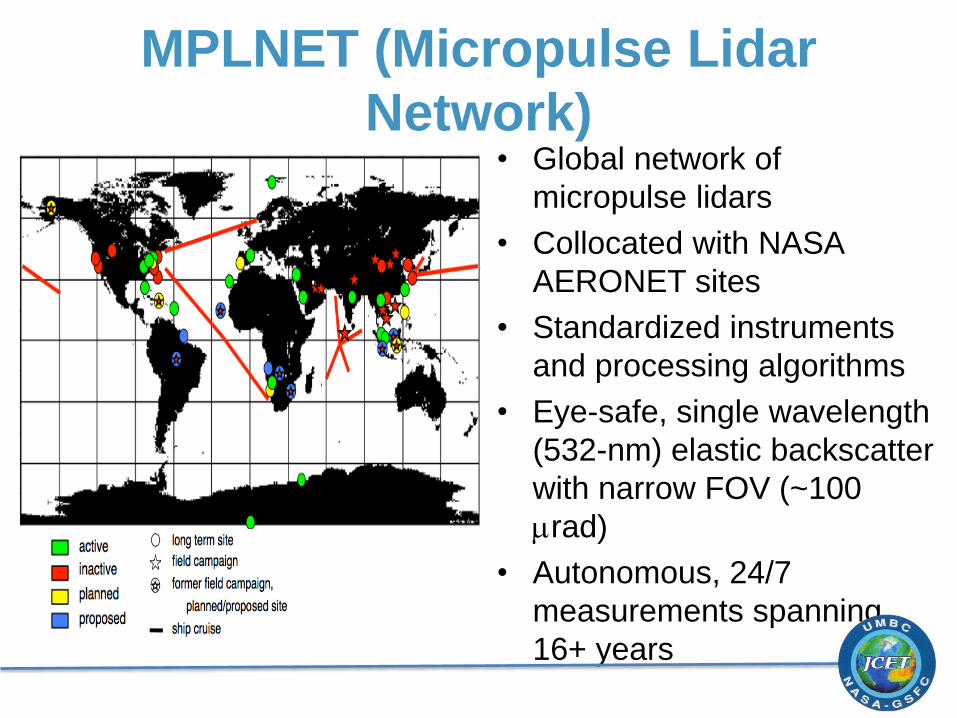
MPLNET (Micropulse Lidar
Network)• Global network of
micropulse lidars
• Collocated with NASA
AERONET sites
• Standardized instruments
and processing algorithms
• Eye-safe, single wavelength
(532-nm) elastic backscatter
with narrow FOV (~100
mrad)
• Autonomous, 24/7
measurements spanning
16+ years

http://mplnet.gsfc.nasa.gov
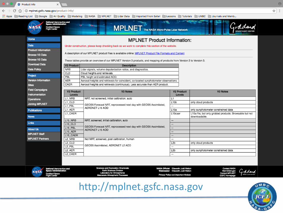
http://mplnet.gsfc.nasa.gov

V3 PBL Height Retrievals
• Wavelet covariance transform utilizes the first derivative of a Gaussian wavelet and a cloud-screened, five-minute average scattering ratio profile
• Canny edge-detection used to detect up to three possible features and fuzzy logic determines the most likely choice for the PBL top height
• A continuity scheme is used to reduce sudden changes in the PBL top height
• Citation: Lewis, J. R., E. J. Welton, A. M. Molod, and E. Joseph (2013), Improved boundary layer depth retrievals from MPLNET, J. Geophys. Res. Atmos., 118, 9870–9879, doi:10.1002/jgrd.50570

V3 PBL Height Retrievals
Issues with collapse and growth periods
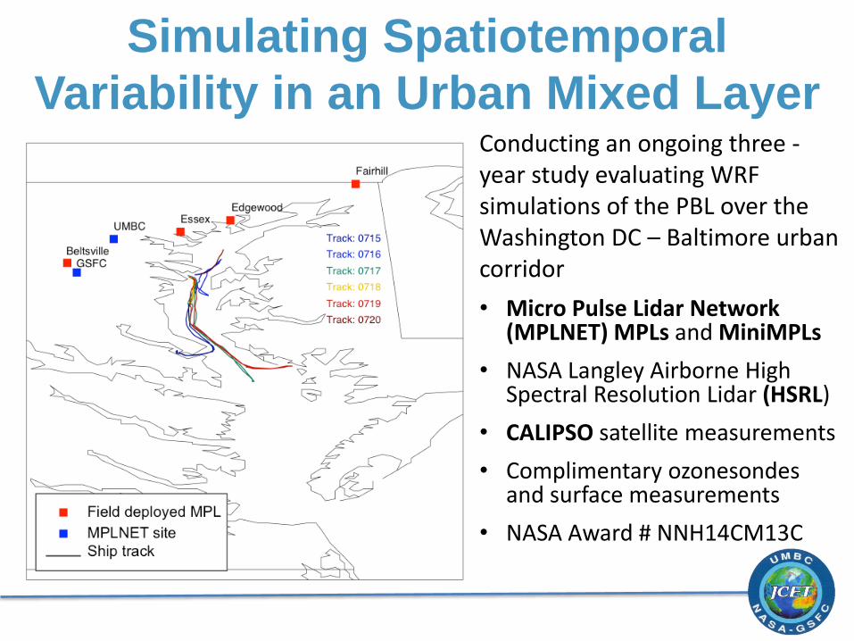
Conducting an ongoing three -year study evaluating WRF simulations of the PBL over the Washington DC – Baltimore urban corridor
• Micro Pulse Lidar Network (MPLNET) MPLs and MiniMPLs
• NASA Langley Airborne High Spectral Resolution Lidar (HSRL)
• CALIPSO satellite measurements
• Complimentary ozonesondesand surface measurements
• NASA Award # NNH14CM13C
Simulating Spatiotemporal
Variability in an Urban Mixed Layer
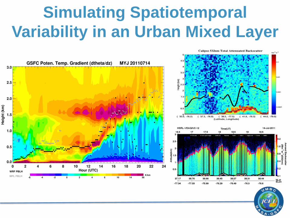
Simulating Spatiotemporal
Variability in an Urban Mixed Layer

![IQ 532 Micropulse green laser treatment for refractory ...Eur J Ophthalmol 18: 934–40. [Crossref] 9. Chen SN1, Hwang JF, Tseng LF, Lin CJ (2008) Subthreshold diode micropulse photocoagulation](https://img.dokumen.tips/doc/110x75/5f3ac13e81ca9d14c954f199/iq-532-micropulse-green-laser-treatment-for-refractory-eur-j-ophthalmol-18.jpg)


![Aerosol Ver.cal Structure as Assessed by the Micropulse Lidar … · 2018. 7. 5. · NRB max: 1.22 R2: 0.57 NRB [Counts km2/ 7J7s] 0 0.2 0.4 Range [km] 0 5 10 18:11:04 NRB max: 1.25](https://img.dokumen.tips/doc/110x75/5fc8ab6bd235a71957512026/aerosol-vercal-structure-as-assessed-by-the-micropulse-lidar-2018-7-5-nrb.jpg)