Embed Size (px)
Citation preview

13
ABSTRACT: ASCIONE A., MICCADEI E., VILLANI F. & BERTI C., Morphostructural setting of the Sangro and Volturno rivers divide area(Central-Southern Apennines, Italy). (IT ISSN 1724-4757, 2007).
Growth of topography in the Apennines has been driven by activetectonics (thrust-related crustal shortening and high-angle normal fault-ing related to crustal extension), regional rock uplift, and surface process-es. Deep erosion has locally removed depositional growth strata leavingprogressive unconformities genetically related to geomorphic featuresthat can be used to interpret Apennine geologic history.
We present a geomorphic and morpho-structural analysis of an un-derstudied, 400 km2 part of the central-southern Apennines coveringAbruzzo, Lazio, and Molise regions thought to have emerged duringthe Early Pliocene and been subjected to protracted, deep erosion sincethen. Our study reveals a high-relief landscape dominated by severalmorphostructures including high-standing, resistant Mesozoic and earlyTertiary carbonates and intervening, erodible Tertiary siliciclastics.Quaternary deposits are few, scattered, and cannot generally be usedfor reconstructing paleo-base levels; however, this study defines andidentifies several paleo-uplands and pediments that may be linked topaleo-base levels.
Cross-cutting relationships between the morphostructures, uplands,and pediments define the long-term geomorphic evolution of the area.Thrust and strike-slip faults were active only in the Miocene and Pliocenewhereas the normal faults have been active during the Quaternary. Thecarbonate ridges were exhumed from the softer siliciclastics mostly in thePliocene and a pre-Pliocene low relief upland was deeply incised. Thebase level fall driving this exhumation and incision is postulated to timethe onset of regional rock uplift of the core of the southern Apennines toits present lofty mean elevation.
KEY WORDS: Morphostructure; Morphosculture; Paleosurface; Ex-humation; Central-Southern Apennines.
RIASSUNTO: ASCIONE A., MICCADEI E., VILLANI F. & BERTI C., Asset-to morfostrutturale del settore di spartiacque Sangro-Volturno (Appenninocentro-meridionale). (IT ISSN 1724-4757, 2007).
È stato condotto un dettagliato studio volto a definire l’assetto mor-fostrutturale e a ricostruire la storia morfoevolutiva di lungo termine diun’area vasta circa 400 km2, situata tra il Lazio, l’Abruzzo e il Molise, acavallo dello spartiacque appenninico, che in questo settore separa i baci-ni del Sangro e del Volturno.
Questo settore di catena, emerso sin dal Pliocene inferiore, è caratte-rizzato da un complesso assetto geologico e un forte rilievo locale. I de-positi quaternari riferibili ad antichi livelli di base sono scarsi, e l’interopaesaggio è dominato da forme di erosione. Lo studio si è basato princi-palmente sull’analisi geomorfologica dei versanti strutturali e delle paleo-superfici. È stata riscontrata una prevalenza di forme controllate passiva-mente dalla struttura (morfosculture), con alti topografici, bordati da ver-santi su faglia, inscritti in rocce carbonatiche molto resistenti all’erosione,e bassi topografici incisi in rocce silicoclastiche, fortemente erodibili. Lanatura bipolare del substrato e l’erosione selettiva che ha agito su di essosembrano essere la chiave della costruzione del rilievo durante il Quater-nario nell’area di studio. Tra il Pliocene e il Pleistocene inferiore si sonoavute le principali dislocazioni tettoniche, lo stesso intervallo di tempodurante il quale la gran parte dell’attuale elevazione assoluta dell’area èstata cumulata. Durante il Quaternario, invece, prevale una forte fase dierosione, responsabile di un forte incremento del rilievo locale. Lamorfodinamica quaternaria sembra essere la risposta a un generale solle-vamento a largo raggio del settore assiale della catena appenninica cen-tro-meridionale.
TERMINI CHIAVE: Morfostruttura; Morfoscultura; Paleosuperficie;Esumazione; Appennino centro-meridionale.
Geogr. Fis. Dinam. Quat.30 (2007), 13-32, 12 figg., 1 tab.
ALESSANDRA ASCIONE (*), ENRICO MICCADEI (**), FABIO VILLANI (***)& CLAUDIO BERTI (**)
MORPHOSTRUCTURAL SETTING OF THE SANGRO AND VOLTURNORIVERS DIVIDE AREA (CENTRAL-SOUTHERN APENNINES, ITALY)
(*) Dipartimento di Scienze della Terra, Università «Federico II»,Largo S. Marcellino 10 - 80138 Napoli, Italy.
(**) Dipartimento di Scienze della Terra, Università degli studi «G. D’Annunzio» Chieti-Pescara, Via Dei Vestini 31 - 66013 Chieti Scalo(CH), Italy.
(***) Istituto Nazionale di Geofisica e Vulcanologia, Via di VignaMurata 605 - 00143 Roma, Italy.
The authors wish to sincerely thank F.J. Pazzaglia and an anonymousreferee for the critical review of the paper and the useful comments thatgreatly improved the text. Stephen Monna is thanked for the useful sugges-tions on the English version of the manuscript and discussion on DEManalysis. Prof. L. D’Alessandro and L. Brancaccio are also thanked for thecontinuous spur on research. Work funded by MIUR grant (60% Facultyfounds, 2006), L. D’Alessandro.
This work is the result of a research carried out by: A. Ascione and E.Miccadei (research guideline, geomorphological analyses), F. Villani (fieldgeomorphological survey, morphometric analyses), C. Berti (field geomor-phological survey and Quaternary stratigraphy). Synthesis of the geomor-phological data, discussions and conclusions are the result of the collabora-tion of all the authors.

14
INTRODUCTION
The reconstruction of the long-term geomorphologicalevolution of the Apennines chain is a difficult task. In fact,topography of the Apennines range resulted from thecombined action of tectonic displacements (related tothrusting and high-angle faulting), large-scale uplift andsurface processes. The single contributions of these factorsto the genesis of relief are hardly detectable. Furthermore,as thrusting and high-angle faulting arranged rocks of vari-able erodibility, differential erosion also played a major role.
This paper assesses the morphostructural setting of theSangro and Volturno rivers divide area (the former flowingtowards the Adriatic sea, the latter flowing towards theTyrrhenian sea), in the axial belt of the Central-SouthernApennines. We aim to reconstruct the Pliocene-Quaternarymorphotectonic evolution of the study area, namely thegenesis of local relief by means of tectonics, erosion andlarge-scale uplift. We also try to give an approximate esti-mate of the cumulative vertical movement of the groundsurface (surface uplift, England & Molnar, 1990) during thePleistocene. We performed morphostructural and morpho-metric analyses, which were used to outline the main fea-tures of topography, the relationships between structuralframework and physiography, and the roles played by tec-tonics and long-term (> 2 Myr) surface processes.
The clear distinction between exogenic and tectonicprocesses as concomitant factors in the building of oro-genic relief, and their complex relationships on scale ofmillions of years (Schmidt & Montgomery, 1995; Howard,1996; Kooi & Beaumont, 1996; Hovius, 2000; Osborn &alii, 2006), have recently been considered as a starting-point to study the large-scale geomorphology of the Apen-nines (see, among the others: Ascione & Cinque, 1999; Bar-tolini, 1999; D’Agostino & alii, 2001; Ascione & Cinque,2003; Ascione & alii, 2003; Bartolini & alii, 2003; D’A-lessandro & alii, 2003; Molin & alii, 2004; Molin & Fubelli,2005; Spagnolo & Pazzaglia, 2005). The assessment of alarge contribution of erosion in the genesis of mountainousrelief, among others, has major implications in the estima-tion of vertical tectonic deformations and uplift rates,which could otherwise be overestimated or misinterpreted.
Morphostructural analysis provides a framework forthe reconstruction of the surface evolution of thrust-beltinteriors, where stratigraphical markers of surface upliftand tectonic displacements are generally quite rare or lack-ing (Burbank & Anderson, 2001). In the Sangro andVolturno rivers divide area the youngest marine depositsare strongly deformed synorogenic clays and sandstones(Miocene - Lower Pliocene in age). They crop out in deepdepressions, hundreds or even thousands of meters belowthe adjacent ridge tops (exposing carbonate Mesozoic-Ter-tiary rocks). On the other hand, younger (Quaternary inage) continental deposits relatable to past base-levels arefew and scattered.
In these unfavourable conditions, typical of mountain-ous settings, the morphostructural approach allows therecognition of the main structural, tectonic and erosionallandforms, along with their relative chronology. We can
reconstruct the main stages of landscape evolution that, intheir turn, may be related to the causative erosional and/ortectonic processes. More in particular, by this approachreliable schemes of fault displacements and large-scale ver-tical movements of ground surface can be hypothesized.The result of our study is a tentative picture of Quaternarytopographic growth of this sector of the Apennines.
Previous works on large-scale geomorphology of CentralApennines (see, among the others: Demangeot, 1965; Dra-mis, 1992; Coltorti & Pieruccini, 2000; D’Agostino & alii,2001; Bartolini & alii, 2003; Pizzi, 2003) generally depict astrong (even more than 1000 m) uplift of the chain axis sincePleistocene times. Our estimates are more conservative. Webriefly discuss the geomorphological and geological reasonsof these results in the final section. On the other hand, weare aware of the intrinsic limits of the morphostructuralmethod and discuss them in an appropriate section.
Many studies are available for the Quaternary exten-sional tectonics affecting adjacent regions to the N (e.g.:the middle-upper Sangro River Valley: Miccadei, 1993;Roberts & Michetti, 2004) and to the S (e.g.: the highVolturno Valley and the Matese massif: Brancaccio & alii,1997; 2000; Corrado & alii, 1997; Cinque & alii, 2000 andreferences therein). There are only few studies aboutPliocene-Quaternary tectonics and geomorphology of theSangro and Volturno rivers divide area (e.g.: Damiani &Pannuzi, 1980). One of our objectives is to clarify theQuaternary tectonics of this region.
METHODS
Our study mainly consisted in combined morphomet-ric and morphostructural analyses.
As regards morphometry, we used SRTM elevation datafor spatial analysis of topography, following some standard-ized procedures described in many papers (see, among theothers: Klinkenberg, 1992; Guzzetti & Reichenbach, 1994;Weissel & alii, 1994 and references therein). The SRTMheight files were first converted in a WGS84 projection andthe latitude/longitude values were transformed in UTM co-ordinates, then we created a regular 90-m grid of elevationdata. We focus on the first-order quantitative properties oftopography, so the main features of landscape (high-ordervalleys, ridges, hillslopes, low-relief surfaces etc.) are stillsatisfactorily represented by such a coarse grid.
We calculated statistical parameters of elevation data(maximum, minimum and mean values, standard devia-tion, skewness), their frequency distribution (elevation da-ta were divided into height intervals of 50 m, and for eachinterval the number of data was extracted) and hypsomet-ric indices (elevation/relief ratio, E/R). High values of dis-persion depict a rugged topography (Klinkenberg, 1992).High values of E/R, together with right-skewed frequencydistribution of elevation, can be related to low values oferosion, and possibly depict landscapes preserving high-standing low relief surfaces. We also analyzed the relation-ships between average slope and elevation. The elevationdata were divided into height intervals of 50 m and for

15
each interval the average terrain slope was computed. Thetrend of a slope vs. elevation curve depicts the vertical dis-tribution of hillslopes and low relief surfaces. A decreasein average slope with increasing elevation, not so commonin mountainous settings (see, among the others: Schmidt& Montgomery, 1995; Kühni & Pfiffner, 2001; Bishop &alii, 2002), is indicative of some high-standing low reliefsurfaces, and requires a geomorphological explanation.Our discussion about average slope is exclusively restrict-ed to its relationships with altitude. We leave out of con-sideration absolute values of slope, because they obviouslydepend on DEM resolution.
We carried out morphostructural analyses through care-ful inspection of topographic maps (1:25000 and 1:10000scale) and aerial photos (1:33000 scale, Volo RegioneAbruzzo, 1990), and through field surveys.
Our goal is discerning the roles of tectonics and ero-sion in the genesis of local relief. We therefore first fo-cused on the following main points: 1) analysis of faultslopes, discriminating between slopes created by tectonics(i.e.: fault scarps), slopes created by differential erosion ofrocks on either side of the fault (i.e.: fault-line scarps) orby the mixed action of differential erosion and fault slip-page (i.e.: fault-related scarps); 2) analysis of structurallandforms due to the attitude of bedrock strata and inter-vening erosional processes (morphosculptures, for example:dip-slopes, hogbacks, mesas, etc.). We then grouped themain structural landforms in few basic categories, follow-ing a scheme proposed by D’Alessandro & alii (2003) anddiscussed in an appropriate section.
The recognition of ancient base-levels and related land-forms is fundamental for constraining estimates of surfaceuplift. We therefore focused on the following points: 1)analysis of erosional/depositional fluvial and lacustrine ter-races and their amount of incision; 2) analysis of relic ero-sional landsurfaces (hereinafter named paleosurfaces); 3)analysis of hydrographic network and its relationshipswith morphostructures.
Paleosurfaces (also said gentle erosional landforms inAmato & Cinque, 1999, or low relief landscapes in Ascione& Cinque, 1999) play a major role in our study. They arerelics of ancient, hanging, low-relief erosional landscapescarved on bedrock, generally preserving beheaded and/ortruncated, low-gradient paleovalleys, which now are com-pletely isolated from the present-day hydrographic net-work. Paleosurfaces are typically found on summit areas,but they can form nested systems, deeply entrenched inmountainous settings. Paleosurfaces indicate the occur-rence of periods during which the erosional processes(mainly fluvial and karstic planation) smoothed the reliefcreated by thrust belt accretion. Estimation of the originalelevation a.s.l. of a paleosurface carved on Mesozoic-Ter-tiary bedrock is also difficult or even impossible. However,the present elevation of these high-standing landformsmay be related only to local offsets or to large-scale uplift,due to regional evidences of their clear involvement in thePliocene - Lower Pleistocene accretion of the Central-Sou-thern Apennines and subsequent Quaternary uplift (Amato& Cinque, 1999; Coltorti & Pieruccini, 2000). Paleosurfaces
have been regarded as the only available markers of long-term (i.e.: Pliocene-Quaternary), large-scale topographicgrowth in this sector of the Central Apennines.
The age estimation of paleosurfaces is a difficult task.Paleosurfaces on summit areas (above 1500-1700 m a.s.l.)have a wide distribution in the Abruzzi Apennines, andmany Authors have dated them back to the Pliocene (seealso: Bosi & alii, 1996; Galadini & alii, 2003). In ourstudy, we used geomorphological correlations with knowndeposits and landforms. We mapped the Quaternary con-tinental deposits relatable to past local base-levels (tra-vertines, fluvial gravels and lacustrine clays) or well knownPleistocene climatic fluctuations (glacial till; see a chrono-logical framework in: Giraudi, 2003). We then made a rel-ative chronology scheme of the tectonic and erosionalevents by means of cross-cut relationships between struc-tural, erosional and depositional landforms. Due to thelack of absolute dating of the aforementioned continentaldeposits, our age estimates of paleosurfaces and otherlandforms are merely relative. Nonetheless, we tried to fitour reconstruction with a reliable geological framework of this sector of the Apennines (Patacca & alii, 1992;Scrocca & Tozzi, 1999; Bosi & alii, 2003; D’Alessandro &alii, 2003).
We finally estimated the magnitude of large-scale verti-cal movement of the ground surface during the Pleis-tocene. Our assumption is that the degree of fluvial inci-sion of the paleosurfaces in the study area roughly equatestheir surface uplift (see, for example: Amato & Cinque,1999; Johansson & alii, 1999; Coltorti & Pieruccini, 2000;Boenzi & alii, 2003; Sobel & Strecker, 2003, etc.).
GEOLOGICAL AND STRUCTURAL SETTING
The study area is located S of Mt. Greco ridge and Nof Venafro Mts., between 41°45’ - 41°36’ N latitude and13°57’ - 14°09’ E longitude (figs. 1a, 1b). This portion ofthe Apennines chain is located at the junction of the twomajor northern and southern Apenninic arcs (Patacca &alii, 1990), and was accreted between Late Miocene andPliocene with NE sense of transport. Following accretion,regional emersion and tilting of the Central-SouthernApennines foredeep took place, leading to a gradual east-wards shift of the Adriatic coastline (Cinque & alii, 1993).Several thrust sheets related to different paleogeographicdomains define a complex structural setting (D’Andrea &alii, 1992; Patacca & alii, 1992; Di Bucci & alii, 1999;Scrocca & Tozzi, 1999). These thrust sheets consist ofMesozoic-Tertiary carbonates and Late Miocene - LowerPliocene siliciclastics. Their original stratigraphical andgeometrical relationships were severely obliterated by re-peated tectonic deformations, occurred until the LatePliocene (Patacca & alii, 1992; Miccadei, 1993; Corrado &alii, 1997). Siliciclastics are in fact almost everywhere de-coupled from their original carbonate basement. Thesethrust sheets now form a complex stack that is offset by N-S, E-W and WSW-ENE trending normal and strike-slipfaults (fig. 1a).

16
FIG. 1a - Structural scheme of the study area (Patacca & Scando-ne, 1989; Di Bucci & alii, 1999). Latium-Abruzzi CarbonatePlatform Unit: 1) siliciclastic deposits (Late Miocene); 2) by-passmargin carbonates (Triassic - Miocene; 3) slope to basin carbo-nates (Jurassic - Miocene). Apulian Carbonate Platform Unit; 4)siliciclastic depodits (Late Miocene - Pliocene); 5) shelf carbona-tes (Jurassic - Miocene); 6) slope carbonates (Cretaceous - Mio-cene). Molisan Units; 7) siliciclastic deposits (Late Miocene); 8)multicoloured clays (Oligocene. Miocene); 9) Thrust; 10) dip-slip fault; 11) strike slip fault; 12) trace of cross section (fig 3a).
FIG. 1b - Simplified morphostructural map of the study area(modified from D’Alessandro & alii, 2003).

17
The westernmost Meta-Mainarde thrust sheet is com-posed of a thick pile (more than 2000 m) of Late Triassicto Middle Miocene carbonate rocks, deposited in a slope-to-basin setting (Patacca & Scandone, 1989; Miccadei,1993). The Meta-Mainarde thrust sheet, which is the high-est one (both topographically and structurally) in the studyarea, is folded into a broad anticline. It is bordered to theE by a N-S trending thrust with a generally E-ENE slip di-rection (Miccadei, 1993), and by a strike-slip fault systemon the southern side (Scrocca & Tozzi, 1999) (fig. 1a).
Similarly, the Montenero Val Cocchiara klippe (Di Bucci& Scrocca, 1997), which crops out in the central and easternportions of the study area, is made up of more than 300 mLower Cretaceous to Middle Miocene carbonates. Somehundreds meters of Late Miocene siliciclastics crop out onthe northern edge of the klippe, above the Middle Miocenecarbonates (Patacca & alii, 1992; Di Bucci & Scrocca, 1997).This thrust sheet shows a general N sense of transport overthe siliciclastics (Di Bucci & Scrocca, 1997) (fig 1a).
The deepest structural unit in this portion of the chaincrops out in correspondence of the Mt. La Rocca, Mt. S.Michele and Mt. della Rocchetta ridges. It is related to theApulia platform, involved in the Pliocene thrusting of theCentral-Southern Apennines (D’Andrea & alii, 1992; Pat-acca & alii, 1992; Di Bucci & alii, 1999; Scrocca & Tozzi,1999; fig. 1a). These ridges are underlain by more than 300m Late Jurassic (Lower Cretaceous in the case of Mt. dellaRocchetta) to Middle Miocene inner shelf carbonates. Thiscarbonate section is followed by Late Miocene - LowerPliocene siliciclastics. Their lower portion consists of a mo-notonous pack of clay and generally thin bedded sandstone,at some places interrupted by wide olistostromes of Creta-ceous marls and cherts. These deposits are more than 2000m thick (Fonteviva-1 well, on the eastern edge of Monten-ero Val Cocchiara klippe; Scrocca & Tozzi, 1999). Theaforementioned ridges are bordered by high angle faults ontheir W and SW sides. To the S, the Mt. S. Michele and Mt.della Rocchetta ridges are bordered by NW-SE and SW-NE trending strike-slip faults (Scrocca & Tozzi, 1999).
The southern termination of the Mt. Greco thrust sheetcrops out N of the Meta-Mainarde massif, between theSangro and Rio Torto valleys. It is composed of a morethan 400 m thick section of carbonate slope deposits, Low-er Cretaceous to Late Miocene in age (Mattei & Miccadei,1991; Miccadei, 1993; fig. 2). In the Scontrone area, a LateMiocene continental vertebrate fauna is reported (Patacca& alii, 2006). It testifies for the presence of wide emergedareas since the Late Miocene. This unit is bordered to the Sby a SW-NE trending dextral strike-slip fault (AlfedenaFault: Mattei & Miccadei, 1991; Miccadei, 1993).
As regards siliciclastics, studies (Corrado & alii, 1998)about the tectonic burial and erosional exhumation of theupper clayey members from the southern termination ofthe Valle di Mezzo and around the southern edge of theMontenero Val Cocchiara klippe, show that these rocksunderwent several hundreds meters of exhumation sincethe Lower Pliocene.
In the study area the continental deposits are generallyfew and scattered (fig. 2). The widest outcrops are repre-
sented by the Middle-Late Pleistocene glacial depositsresting at the piedmont of the Meta-Mainarde massif(Cinque & alii, 1990; Jaurand, 1998; Giraudi, 2003).Along the E and S borders of Mt. della Rocchetta, at theVolturno river springs, a thick travertine plate crops out:its maximum age is about 70 kyr, according to 230Th analy-ses (Brancaccio & alii, 1988). The Sangro River Valley, between Alfedena and Castel di Sangro, hosts Late Pleis-tocene to Recent alluvial deposits, just about 20 m thick(Miccadei, 1993; Capelli & alii, 1998).
In this paper we discuss the aforementioned continen-tal deposits and we add new data about some small out-crops, with the aim of unravelling the evolution of hydro-graphic network in the study area and its possible relation-ships with uplift.
PHYSIOGRAPHY AND TOPOGRAPHY
The study area is generally mountainous, particularly in its western portion (figs. 3a, 3b, 4a). The main physio-graphic feature is represented by the Meta-Mainarde mas-sif, with several peaks exceeding 2000 m. a.s.l. (from N toS: Mt. Tartaro, 2191 m; Mt. Petroso, 2249 m; Mt. Meta,2242 m; Mt. Metuccia, 2102 m; Mt. a Mare, 2160 m; Mt.Cavallo 2039 m; Mt. Mare 2020 m). The massif is borderedto the E by the narrow and deep Valle di Mezzo, orientedin a N-S direction. To the N, this valley is bordered by theNW-SE trending Mt. La Rocca ridge (1544 m), while tothe E the N-S trending Mt. S. Michele (1176 m) and Mt.della Rocchetta (973 m) ridges are present (fig. 1b).
FIG. 2 - Stratigrafic scheme of Quaternary deposits outcropping in thestudy area (Brancaccio & alii, 1988; Giraudi, 1997; Capelli & alii, 1998).1) slope deposits; 2) conglomerates; 3) travertine; 4) lacustrine deposits;
5) moraine. Time axis not in scale.

18
In the study area, the Apennines main divide (whichcoincides with the Sangro and Volturno rivers divide) hasan average elevation of about 1300 m a.s.l. It has a N-Sorientation on the highest peaks of the Meta-Mainardemassif (fig. 4a), then it abruptly turns to the E and de-scends for about 1000 m towards the hills of the Cam-pitelli area (W of Mt. La Rocca) and the hills surroundingMontenero Val Cocchiara (at about 1100 m a.s.l.). Therethe landscape is characterized by small, smooth, isolatedtops and very large interfluves with gentle slopes. Northof the Apennines main divide (i.e. in the Adriatic sector ofthe study area) and S of the Mt. Greco massif, there aretwo main physiographic features: from W to E, a gentlyhilly landscape, dissected by the deep and narrow SangroRiver gorge (between Barrea and Alfedena), stands about300 m higher than the adjacent, wide and flat Castel diSangro Plain.
In the western portion of the study area, the valleyscross-section is generally V-shaped and their width is verysmall (1 km or less) if compared to the interfluves spacing(some kilometers in the Meta-Mainarde massif). In theeastern portion the valleys become wider with gentlerslopes, but still interfluves retain noticeable width (espe-cially on the Montenero Val Cocchiara klippe). The onlyexception is represented by the Mt. La Rocca, Mt. S.Michele and Mt. della Rocchetta sharp and narrow ridges.
Topographic properties of the study area were com-puted from a 90-m DEM and they are summarized in table1. The average elevation is higher than 1000 m. The fre-quency distribution of elevation data (fig. 4b) is roughlysymmetrical (skewness is 0.543) and platykurtic (kurtosisis –0.408). It shows that the bulk of topography (about43%) is sited between 800 m and 1150 m a.s.l. (with amodal peak at 801-850 m elevation class). This is also con-
FIG. 3a - Simplified geological cross-section (see fig. 1a for legend).
FIG. 3b - Panoramic view of the main physiographic units in the western part of the cross-section shown in fig 3a. On the background, the eastern escarpment of Meta-Mainarde massif; then, on the right the NE escarpment of Mt. La Rocca ridge and, to the left, the eastern escarpment of Mt.
S. Michele ridge; on the foreground, the eastern escarpment of Mt. della Rocchetta ridge and the Castel San Vincenzo travertines plate.

19
firmed by quite high dispersion (standard deviation is 411m). The normalized hypsometric curve, with a slight con-cave-up shape, is shown in fig. 4c (E/R is 0.416).
The relationships between average slope and elevationare shown in fig. 4d. Absolute values of slope are merelyindicative, due to their strong dependence on DEM reso-
TABLE 1 - Main statistical and morphometric parameters of the Sangro-Volturno divide area (data from 90-m DEM)
Hmax Hmin Hmean dispersion skewness kurtosis E/R
2194 m 295 m 1085 m 411 m 0.543 -0.408 0.416
FIG. 4a - Contour map of the study area,from the 90-m DEM (100 m contour inter-val). The white line indicates the Apenninesmain divide (here separating the Sangro andVolturno rivers drainage basins). Some ma-jor endorheic areas along the divide are foundat a glacial trough outlet (Meta-Mainardemassif), on the W, and in a karstic basin(Montenero Val Cocchiara klippe), on the
E. See details in the text.
FIG. 4b - Elevation histogram of the studyarea (data from the 90-m DEM).

20
lution, and they are not took into consideration in our dis-cussion. The curve initially shows a gradual increase in aver-age slope with elevation, but after a sort of threshold (about20°-22°, between 1350 m and 1700 m), the average slopeclearly decreases, reaching a local minimum (about 12°-14°)between 1850 and 2100 m. Therefore, at high altitudes a
negative correlation between average slope and elevationcan be envisaged. Furthermore, the curve shows some othersubtle relative minima (at 801-850 m, 951-1000 m, 1101-1150 m, 1401-1450 m, 1701-1750 m) which in part corre-spond to the secondary modal peaks of the frequency distri-bution of elevation (fig. 4b). Both of these aspects are clear-
FIG. 4c - Hypsometric curve of the study area. Cumulativevalues of area-altitude pairs are normalized with respect tothe maximum planar area (404.9 km2) and maximum eleva-tion (2194 m) according to elevation data of 90-m DEM.
FIG. 4d - Average slope vs. elevation curve (the error bars indicate standard deviation of slope values for each 50-m elevation class). Data from 90-m DEM. See details in the text.

21
ly related to the presence of several sets of low relief sur-faces that occur also on the summit areas (Meta-Mainardemassif and Montenero Val Cocchiara surroundings).
MORPHOSTRUCTURAL SETTING
In this section we describe the salient geomorphologi-cal and morphostructural elements of the study area, fol-
lowing the geographical distribution of the main physio-graphic units. The collected data have been in part synthe-sized in a simplified morphostructural map (fig. 5).
The Meta-Mainarde massif
The study area includes just the eastern portion of theMeta-Mainarde massif. It is part of the western Marsica
FIG. 5 - Morphostructural map of the Sangro-Volturno divide area.

22
range, one of the greatest orographic features in the wholeApennines chain. The massif appears as a huge prismaticbody (figs. 3b, 4a) with a roughly tabular summit, gentlysloping towards WSW, and bordered to the N, E and S byhigh escarpments. The topographic culmination of theMainarde range roughly corresponds to the anticlinal axis,here exposing Cretaceous-Palaeogene carbonates, while inthe SW and the NE flanks Jurassic-Cretaceous and Palaeo-gene-Miocene carbonates respectively crop out.
Several paleosurfaces are found up to 2000 m a.s.l. Insome cases, W and SW of the main peaks alignment, theyhave a local structural control, due to the attitude ofbedrock strata, especially in the most elevated areas (e.g.:Coste dell’Altare area, fig. 6). These paleosurfaces anywaypreserve some elongated patches of a relic hydrographicnetwork with low-gradient, beheaded trunks and windgaps, generally flowing towards the S and SW (e.g.: bet-ween Mt. Cavallo and Mt. a Mare). In the Abruzzi interi-ors, a few kilometers N of the study area, several paleosur-faces at similar elevations (> 1600 m a.s.l.) are reported(Bosi & alii, 1996; Galadini & alii, 2003) and, according tothose authors, their age is generically Pliocene. In fact, allthe Lower-Middle Pleistocene continental deposits in thissector of the Apennines are hosted in valleys deeply en-trenched in the highest paleosurfaces. Possibly, the highestMeta-Mainarde paleosurfaces were generated in proximityof the sea level, but their relic hydrographic network testi-fies for a more decisive sub-aerial moulding. The abrupttruncation of this ancient network is interpreted as a re-sponse to uplift of the Meta-Mainarde thrust sheet.
The escarpments bordering the massif are set up onthrust planes (northern and eastern slopes) and strike-slipfaults (southern slope). They put the carbonates of the
Meta-Mainarde thrust sheet in contact with the siliciclas-tics. The 11 km long eastern escarpment is N-S oriented,and its height varies from 300 m to over 1000 m. It has apolyphasic transversal shape, due to the presence of someplanar paleosurfaces that cut through strata with variabledip (e.g.: La Ferruccia area, at 1750 m a.s.l.; fig. 7). Themore than 11 km long southern escarpment has an E-Worientation. It also has a very variable height, with a maxi-mum value of 1000 m. It possesses a polyphasic transversalshape, for the presence of paleosurfaces between 1400 mand 1600 m a.s.l. (e.g.: Costa S. Pietro area, fig. 5), whereseveral hanging valleys can be observed.
A spectacular morphological signature of the massif re-lies on its set of glacial cirques and troughs. They originat-ed during the cold stages of the Middle-Late Pleistocene(Cinque & alii, 1990; Jaurand, 1998; Giraudi, 2003; fig. 9).Two main groups of Late Pleistocene cirques can be dis-tinguished at different heights: the first one at 1750-1900 m(Mt. Metuccia, Mt. a Mare, Coste dell’Altare, Mt. Mare),the second one at 1950-2100 m (Mt. Meta, Coste del-l’Altare). The main glacial troughs (e.g.: Pagana Valley) are4-6 km long, and extend up to 1600-1700 m a.s.l., showinga clear U-shaped cross section.
The Mt. S. Michele, Mt. La Rocca and Mt. della Rocchettaridges
East of the Meta-Mainarde massif there are three nar-row carbonatic ridges (the Mt. S. Michele, Mt. La Roccaand Mt. della Rocchetta). They show a very similar mor-phostructural setting.
The Mt. S. Michele ridge is N-S oriented and the bedsdip almost constantly 60°-70° to the E. The western slope
FIG. 6 - Paleosurfaces in the cen-tral-eastern portion of Meta-Mai-narde massif (hatched, in trans-parency), around Coste dell’Alta-re area. View from Mt. Meta peak
(2242 m), towards the S.

23
is a 6 km long fault-line scarp with variable height (rangingbetween 100 m and 400 m). It is transversally cut by the300 m deep Rio Colle Alto water gap (fig. 5). The easterndip-slope, partially covered by siliciclastics, also shows aslightly variable height with well preserved flat irons.
West of Mt. S. Michele, the Valle di Mezzo is a narrowstructural corridor, hosting siliciclastics and a thin cover (afew meters) of coarse slope debris and reworked glacialdeposits. The latter consist in rounded, carbonate cobblesand boulders, in a yellowish sandy matrix. In this valleysome paleosurfaces at 900-1000 m a.s.l. are preserved (fig.5). In particular, at Casone del Medico (1050 m a.s.l.), asmall, flat paleosurface carved on siliciclastics and carbon-ates remoulds the western fault of the Mt. S. Michele andis clearly linked to a wind gap that cuts transversally theridge.
The Mt. S. Michele and Mt. La Rocca ridges are sepa-rated by another very narrow valley (Vigna Valle Lunga),underlain by siliciclastics. The latter ridge has a NW-SEorientation and it is bordered to the SW by a more than 5km long fault-line scarp. The height of this fault-line scarpincreases from the NW (where it is few tens of meters) tothe SE, with a maximum range of about 500 m. The crossprofile of this slope shows a polyphasic shape, due to thepresence of a very steep basal cliff, at some places higherthan 100 m and about 3 km long (fig. 5). The thick slopedebris cover at the piedmont shows no evidence of fault-ing. The north-eastern side of Mt. La Rocca is a dip-slope
displaced by transversal faults, which isolate some hog-backs (fig. 5). Its height rapidly increases southeastwards,while it gradually disappear under the siliciclastics movingtowards the Apennines main divide.
The 2.5 km long Mt. della Rocchetta ridge rises on aslightly undulated landscape carved on siliciclastics. Theridge is N-S oriented, with a fault-line scarp on the W sideand an eastern dip-slope (the beds dip constantly 40° tothe E). The western fault line-scarp has a very variableheight (ranging from nearly zero, in correspondence of LaForcella paleosurface, up to 400 m; fig. 8). It shows a basalscarplet whose height irregularly ranges between 1 m and15 m: it can be followed all along the western slope, withthe exception of La Forcella area (at 800 m a.s.l.), where itdisappears under the siliciclastics. At the base of the east-ern dip-slope, the Rocchetta al Volturno travertine platecrops out. It covers a siliciclastic bedrock and forms twobroad terraced depositional surfaces at 550 m and 500 ma.s.l., with an intervening progradational slope (Brancaccio& alii, 1988).
The Castel San Vincenzo area
The hilly area comprised between the Mt. S. Micheleand Mt. della Rocchetta ridges is underlain by siliciclastics.It gently slopes towards the E. Very small paleosurfacesare present between 1000-700 m a.s.l. (fig. 5). Near CastelSan Vincenzo town, two of these paleosurfaces are cov-
FIG. 7 - Paleosurface carved on limestones (hatched, in transparen-cy), at La Ferruccia area, Meta-Mainarde massif. View from the S.

24
ered by continental deposits. In the first case, the town itself is sited on a 40 m thick travertine plate, which standsover an erosional surface cutting siliciclastics. Nearby, alittle paleosurface is covered by a thin (about 10 m) con-glomerate deposit, whose top is at 754 m a.s.l. (fig. 2). Thisconglomerate in its basal portion shows a chaotic texture,and is composed of mainly carbonatic, arenaceous and sub-ordinately cherty pebbles and cobbles, embedded in a clayeymatrix. It grades upward into a massive clayey deposit.The basal conglomerate could be the a debris-flow, whilethe deposit as a whole can be related to a fluvial-lacustrineenvironment. The Castel San Vincenzo conglomerate, asthe adjacent travertine, hangs more than 100 m over thepresent-day active thalwegs of the Volturno River basin.
WSW of Castel San Vincenzo, at 780 m a.s.l., we foundanother completely isolated conglomerate outcrop. Thisconglomerate is almost exclusively composed of MiddleMiocene calcarenites, most probably fed by the easterndip-slope of the neighbouring Mt. S. Michele ridge. Itrests on the top of the Colle Salamuni hill, more than 150m high over the next active thalweg.
The continental deposits in the Castel San Vincenzoarea testify local ancient base-levels at least 100-150 mhigher than today. This implies a subsequent radical reor-ganization of river network, with a noticeable amount ofsiliciclastics erosion. The remnants of this paleo-landscapeare found in correspondence of the small paleosurfacesresting between the Mt. S. Michele and Mt. della Rocchet-ta ridges. The morphological position of the conglomerateoutcrops is nowadays completely suspended. Therefore,they are certainly older than the Rocchetta al Volturnotravertine, which grades into the recent Volturno alluvial
plain and stands 200-250 m below the Castel San Vincen-zo travertine. For this reason, these conglomerate outcropscan be tentatively ascribed to the late part of Middle Pleis-tocene. The aforementioned paleosurfaces are clearly olderthan the Castel San Vincenzo deposits and younger thanthe paleosurfaces standing around the Apennines dividearea over 1000 m (see next). Therefore, a general MiddlePleistocene age for these landforms can be confidentlyhypothesized.
The Apennines divide area around Campitelli
North of Mt. La Rocca, an arch-shaped morphologichigh near Campitelli depicts the present-day divide of theSangro and Volturno rivers. Its average elevation decreaseseastwards from about 1600 m to 1100 m a.s.l. The bedrockis made up of siliciclastics and sparse carbonate spurs.Between Campitelli and Valle Fiorita, wide outcrops ofglacial deposits (fed by the neighbouring Meta-Mainardemassif) and associated moraines are present (Cinque &alii, 1990; Jaurand, 1998, fig. 9). The most recent oneshave a very fresh morphology and the Authors relatedthem to the Last Glacial Maximum (about 23-21 kyr BP:Giraudi, 2003). The Apennines main divide splits aroundthe Valle Fiorita moraines (fig. 5), which now form an en-dorheic area hosting some lacustrine, Holocene deposits(Giraudi, 1997).
Just E of Campitelli area, two large outcrops of glacialdeposits, more than 100 m thick, form the body of LaMontagnola (1566 m) and Rocca Ranalda (1465 m) hills.These deposits consist of a chaotic mixture of carbonateboulders, with variable roundness, embedded in an abun-
FIG. 8 - The western escarpment of Mt. della Rocchetta (view from the W). Note discontinuous basal scarplet and the variable height of mountain front,which almost disappears in the middle of the ridge (La Forcella area). On the right, the fault plane is shown where it reaches its maximum height (15 m).
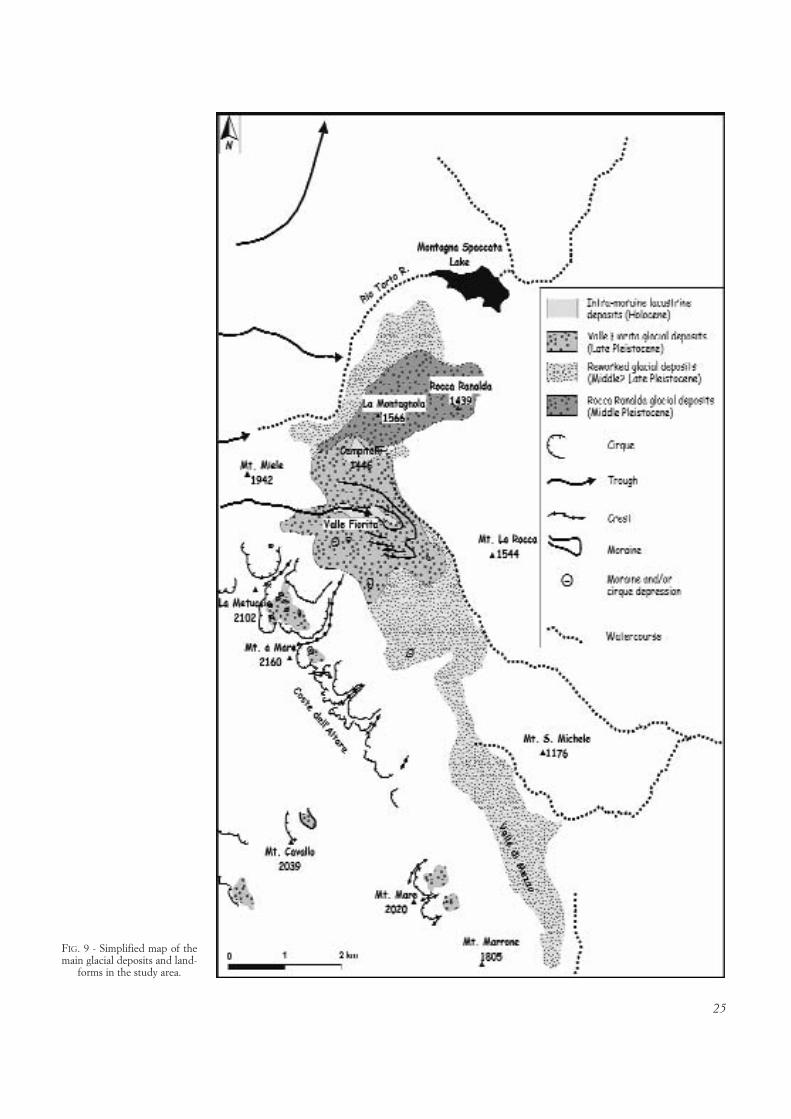
25
FIG. 9 - Simplified map of themain glacial deposits and land-
forms in the study area.

26
dant, yellowish, sandy-silty matrix. They form isolatedtopographic highs and clearly hang over the adjacent activethalwegs. They can be followed to the N until about 1250m a.s.l. The age of these glacial deposits is unknown, any-way we hypothesize a late Middle Pleistocene age. In fact,these depositional landforms completely lost their originalmorphology, due to the strong incision they were subject(more than 150 m), while the Late Pleistocene landformsare still perfectly preserved. Moreover, these ancient de-posits form isolated highs, and they hang over valleys host-ing four orders of Late Pleistocene fluvial terraces (seenext), so they are surely older than these terraces.
North of Campitelli, in the Adriatic flank of the studyarea, the Rio Torto Valley is incised in a narrow corridorbetween the north-eastern termination of the Meta-Mainarde massif and the southern termination of Mt. Gre-co ridge. Bedrock is made of siliciclastics, while in the finaltrunk the river cuts through Cretaceous-Miocene carbon-ates, giving rise to a more than 70 m deep gorge. In the leftflank of the valley some small ridges, bordered by fault-line scarps on their W side and dip-slopes on their E side(generally exposing Miocene carbonates) are present (e.g.:the N-S trending Barrea fault-line scarp). The landscape isdominated by very wide paleosurfaces carved on pelitic-arenaceous turbidites, between 1200-1000 m (fig. 10).These paleosurfaces can be correlated with other paleosur-faces, cutting both carbonates and siliciclastics, in the leftflank of the Sangro River gorge, at 1200-1300 m. Numer-ous, well preserved, beheaded and hanging fluvial-karsticvalleys, sometimes with a sinuous channel pattern, can beobserved NW of Alfedena and Scontrone towns (fig. 5).
All the aforementioned relics of paleo-landscape (bothpaleosurfaces and the paleovalleys inside) hang above the
thalweg of the deep and narrow Sangro River gorge(WNW of Scontrone town, fig. 5), which stands 300-400m below, between about 930 and 870 m a.s.l.. These pale-osurfaces are a striking example of ancient base-levelscompletely isolated from present-day hydrographic net-work. The Sangro River gorge, due to its length (> 6 km),depth (even more than 400 m), sinuosity, and clear discor-dance with the structures it cuts (e.g.: the Barrea fault-linescarp), is superimposed. This means that the Sangro Riveroriginally flowed in a wide, low gradient valley whose rem-nants are represented by the paleosurfaces now resting at1200-1000 m between Barrea and Alfedena («paleo-San-gro» valley: see the final section).
The Middle Pleistocene glacial deposits of La Montag-nola and Rocca Ranalda partially stand over the middleRio Torto Valley paleosurfaces, that surely pre-date thisdepositional event (see next).
The Montenero Val Cocchiara area
The Montenero Val Cocchiara klippe is a broad opensyncline, with beds generally dipping gently towards theN. This klippe forms a horse-toe shaped thrust-ridge. Eoce-ne-Miocene limestones crop out on the main topographicculminations, particularly in the western and northeasternportions of the klippe, where the thin (some meters) silici-clastics cover is at places still preserved (that is, severalhundreds meters of siliciclastics are nowadays missing). Inthe central part of the area, the Pantano Zìttola (fig. 5) is a4 km long flat-bottomed polje, NNE-SSW oriented. It isnot bounded by any high angle fault, and its origin seemsclearly related to the outcropping impermeable siliciclas-tics, in the footwall of the klippe basal thrust.
FIG. 10 - Wide paleosurface (hat-ched, in transparency) carved onsiliciclastic bedrock in the leftflak of the Rio Torto Valley, atabout 1100 m a.s.l. View towardsthe S. On the background, LaMontagnola hill (made of han-ging, Middle Pleistocene glacialdeposits) and the Meta-Mainarde
massif.

27
This klippe hosts the widest paleosurfaces in the studyarea (fig. 5), and they now stand between 900 m and over1100 m a.s.l. The average elevation of these paleosurfacesin the western portion of the klippe is quite similar to theones preserved in the middle Rio Torto Valley. Moreover,several beheaded, sinuous, relic valleys, flowing with verylow gradient from NW to SE in this portion of the klippe,suggest the possible ancient continuity of all these patchesof paleo-landscape.
The Castel di Sangro Plain
The Sangro River Valley widens after the junction withthe Rio Torto River, giving rise to an alluvial plain about 2km wide and more than 5 km long, between about 870 mand 830 m a.s.l. (Castel di Sangro Plain). The alluvial de-posits are about 20 m thick (Capelli & alii, 1998). Fourterraces have been recognized, in both the valley flanks.The highest terrace, near Villa Scontrone town, in the leftflank of the valley, stands about 50 m over the thalweg, at920-915 m a.s.l.. It is represented by some erosional sur-faces carved on siliciclastics, hosting small patches of car-bonate gravels. The second terrace, carved on both theflanks of the valley, stands at 900 m a.s.l. It is part of thedepositional surface on which Alfedena was built. It ismade of calcareous pebbles fed by both Rio Torto andSangro rivers. Immediately below, the third depositionalterrace stands on both the flanks of the valley, between870 m and 850 m a.s.l., in clear continuity with the bot-tom of Pantano Zìttola. The fourth, Holocene terrace isdepositional, and it stands 1-2 m above the present-daythalweg.
There is more than 300 m of relief between these LatePleistocene-Holocene Castel di Sangro Plain terraces andthe paleosurfaces suspended by the Sangro River gorgebetween Barrea and Alfedena.
Some other paleosurfaces, underlain by siliciclasticsand gently sloping to the W, can be found in the rightflank of Castel di Sangro Plain, from 870 m up to over1000 m a.s.l.
General remarks on morphostructural setting of the study area
At the end of this section, some general remarks, usefulfor the next discussion and interpretation, can be brieflypointed out.
As regards morphostructures, it was observed that: 1)all the slopes bordering the main topographic highs put incontact carbonates and siliciclastics; 2) the elevation of thecarbonates-siliciclastics limit along each slope is extremelyvariable, lowering towards the ridge edges; 3) the few, apparently fresh basal scarplets (e.g.: Mt. della Rocchettawestern slope; Barrea fault), have a very discontinuous ex-pression which disappears at the ridge edges, i.e. wherethe fault trace crosses the only siliciclastics; 4) no Quater-nary depocenter relatable to faulting-induced dammingwas found; 5) no tectonic displacement of recent continen-tal deposits (both glacial deposits, talus scree or others)was found.
As regards paleosurfaces, it was observed that: 1) sev-eral paleosurfaces are preserved all over the study area, inthe 2100-750 m elevation range, carved both on carbon-ates and siliciclastics; 2) they generally appear reciprocallynested, with no clear evident displacements by means ofhigh-angle faults (i.e. no evident tectonic duplication ofpaleosurfaces was found); 3) some paleosurfaces seal thelateral prosecution of fault-bounded slopes (e.g.: Casonedel Medico and La Forcella sites); 4) the paleosurfacesstanding over 1600 m are most probably Pliocene in age,and this is surely true for the highest ones on the Meta-Mainarde massif, which could have been generated inproximity of the sea level; 5) the paleosurfaces standing at1200-1000 m are the widest and best preserved in thestudy area, are most probably Lower Pleistocene in ageand are deeply incised (300-400 m); 6) the paleosurfacesstanding between around 800-750 m are Middle Pleis-tocene in age and are locally deeply incised (150-200 m).
As regards the hydrographic network and incision phe-nomena, it was observed that: 1) some diaclinal water gaps(e.g.: the Rio Colle Alto and Sangro River gorges, the latterhaving a sinuous path) are superimposed across the mor-phostructural highs; 2) the elevation of siliciclastic coveron fault-related and fault-line scarps drastically lowers incorrespondence of these diaclinal water gaps; 3) the lateMiddle Pleistocene continental deposits (both in the Adri-atic and in the Tyrrhenian flank of the study area) were in-cised for at least 100-150 m; 4) the highest fluvial terracein the Castel di Sangro Plain (Late Pleistocene in age)stands 50 m over the present-day thalweg and more than300 m below the paleosurfaces at 1200-1000 m in the mid-dle Sangro River valley.
DISCUSSION AND CONCLUSIONS
The roles of erosion and tectonics
The main results of our analyses can be summarized infew basic points. The morphostructural setting of thestudy area seems to be dominated by structure-controlledlandforms (e.g.: Ascione & Cinque, 1999), or morphosculp-tures (see D’Alessandro & alii, 2003 for a comprehensivediscussion). According to the scheme proposed by D’Ales-sandro & alii (2003), we grouped the main morphostruc-tural features in some simple categories. They relate eachmain structural landform to its tectonic and geomorpho-logical setting (as described in the previous section; figs.1a, 1b, 5). We namely distinguished among: faulted homo-cline ridges, i.e. ridges bordered by a fault-related/fault-line scarp and a dip-slope on their sides (e.g.: the Mt. S.Michele, Mt. la Rocca, Mt. della Rocchetta ridges); ex-humed thrust ridges, i.e. thrust-related spurs exhumed by aprevious erodible cover and bordered by fault-line scarpsand thrust-related scarps (e.g.: the Montenero Val Coc-chiara klippe); exhumed anticlinal ridges, which are a varia-tion of the previous category, when the exhumed structureis a fault-related fold, bounded by fault-line/fault-relatedscarps (e.g.: the Meta-Mainarde massif). All of them are

28
landforms with a passive structural control, owing theirexpression mainly to differential erosion phenomena. Dif-ferential erosion was enhanced by the occurrence of twomain bedrock types, i.e. carbonates and the often uncon-solidated, largely clayey siliciclastics, with a strikingly dif-ferent erodibility.
There are only few available data to quantify the re-lative hardness of carbonates and softness of siliciclastics,either in general (see, for example: Saunders & Young,1983; Osborn & alii, 2006) or particularly in the case ofthe long-term geological history of the Apennines. Studieson exhumation of Apennines Tertiary siliciclastics (strong-ly dependent on the analytical methodology and the as-sumptions made about past geothermal gradients) give ro-bust evidence that these rocks are subject to high exhuma-tion rates, which can be confidently converted to erosionestimates. Bartolini & alii (2003) summarize a long list ofworks regarding the exhumation of Northern Apenninesrocks: average exhumation rates > 1.5 mm/yr in the last 2Myr, affecting since their surface exposure Miocene sand-stones (now outcropping on the Apennines divide) implystrong erosion since the Late Pliocene. As regards the Central Apennines, Calamita & alii (2004) calculated 2500-3000 m of exhumation in the last 4-5 Myr for several sam-ples of Miocene-Pliocene foredeep sandstones and clays,now outcropping in some deep depressions, between theMarsica and Gran Sasso ranges.
Geomorphological evidences collected in the Central-Southern Apennines in the last years (e.g.: Brancaccio& Cinque, 1988; Ascione & Cinque, 1999) testify, in thistemperate climatic settings, for differential erosion pro-moted by the juxtaposition of carbonates and siliciclastics,suggesting very low rates of carbonates downcutting anddownwearing (mainly due to karstic dissolution) com-pared to those affecting the siliciclastics. However, thelandscape of the region gives the most striking evidence ofthe different erodibility of these rock types: topographichighs are carved in carbonates, they often preserve largesummit interfluves bounded by steep slopes and are cut bydeep and narrow water gaps; the adjacent topographiclows are underlain by siliciclastics, with wide valleys andgentle slopes subject to widespread landsliding.
Besides the aforementioned features, our study area of-fers further evidence of the different erodibility of thesebedrock types. In fact, with the exception of the Meta-Mainarde massif, where the summit areas (at 2000-2200 ma.s.l.) expose Cretaceous-Paleogene limestones (and only atthe northern rim of the anticline, below 1600 m a.s.l.,Miocene limestones crop out), the carbonates downwearingaffecting all the other thrust sheets is negligible, presumablyno more than some tens of meters: the top of Miocene car-bonates is well preserved on the Mt. Greco, Mt. la Rocca,Mt. S. Michele, Mt. della Rocchetta and Montenero ValCocchiara units. On the other hand, huge volumes of silici-clastics were eroded everywhere: the Mt. Greco, MonteneroVal Cocchiara and Mt. La Rocca units were stripped of sev-eral hundreds meters of Late Miocene - Lower Pliocene clayand sandstone. Since the genesis of the oldest paleosurfaces,particularly those cutting carbonates, a certain degree of
karstic and sub-aerial reworking is likely. Anyway theiroverall erosion is negligible if compared with the subse-quent lowering of the adjacent valleys carved on siliciclas-tics. Therefore, paleosurfaces can be confidently considereda tool for estimating long-term surface uplift.
In our study area, the occurrence of paleosurfaces fromsummit areas to progressively lower elevations (which, atsome places, give rise to polyphasic slopes, e.g.: the easternand southern slopes of the Meta-Mainarde massif) appearsas the response to a stepped erosional lowering of thetopographic surface. Such a scenario does not completelyrule out important tectonic displacements of the topo-graphic surface in this sector of the Apennines. The sepa-ration of local tectonics ad erosion in the genesis of reliefalong each fault-related slope is however a very difficulttask. The cross-cut relationships between fault-related/thrust-related scarps and paleosurfaces can offer a solution(fig. 12). We discuss them in the followings.
The contribution of erosion in the genesis of reliefaround the Meta-Mainarde massif is mainly suggested bythe very variable height of its eastern and southern escarp-ments. These more than 1000 m high slopes could be theresult of an exclusively thrusting-related uplift or, con-versely, they could have been generated by a progressivedismantling of the siliciclastics ahead of the thrust ramp.Maybe a combination of the two processes can better ex-plain the complex relief genesis and the polyphasic shapeof these slopes. The gentle tilting to the SW of the highest(1900-2100 m) paleosurfaces might have resulted fromearlier thrust activity (in this case, the highest paleosur-faces should pre-date or be coeval to thrusting). It appearsclear, anyway, that most of relief of this massif was alreadyaccrued when a low relief landscape, now resting as paleo-surfaces at 1200-1000 m (between the high Rio Torto Val-ley and the Valle di Mezzo), was forming. This means that,during the Lower Pleistocene, the Meta-Mainarde massifhad already gained no less than a thousand meters of reliefover the adjacent «paleo-Sangro» valley.
In the case of the Mt. S. Michele and Mt. della Roc-chetta ridges, the two small paleosurfaces at Casone delMedico (at 1050 m) and at La Forcella (at 800 m) clearlyseal the fault displacements on their western flanks, pre-sumably between Lower and Middle Pleistocene times(fig. 12). In both cases, these paleosurfaces stand about200 m over the next active thalweg and about 150-200 munder the ridge crests. The relative elevation of the paleo-surfaces over the thalweg is indicative of the amount ofdowncutting occurred since their moulding. The relativeelevation of the crests over the paleosurfaces can be due totectonic displacement and/or differential erosion. Theclear separation of tectonics and erosion is very difficult,anyway Pleistocene morphological offsets along thesefaults are on the order of about 200 m.
With the exception of the Mt. La Rocca structure,whose southwestern fault-related scarp suggests possibletectonic activity also during Middle Pleistocene times, thestudy area lacks any clear stratigraphical and morphostruc-tural evidence of Middle-Late Pleistocene local tectonicactivity.

29
The long-term geomorphological evolution
We outline a possible scheme of the long-term geomor-phological evolution of this sector of the Apennines, withparticular attention to the relief genesis and surface uplift(fig. 11). In this scheme, some elements play a major role,such as local tectonic uplift coeval with thrust-belt accre-tion, large-scale uplift and differential erosion.
As regards the Meta-Mainarde massif, probably sincethe Lower Pliocene the summit paleosurfaces were uplift-ed by means of thrusting (fig. 12). This uplift was likelydiscontinuous in time. In fact, other low relief surfaces onthe eastern and southern escarpments of the massif, nowresting at 1750-1400 m, were moulded. At the end of thePliocene, the Meta-Mainarde massif had reached no lessthan one thousand meters of elevation over the adjacentareas to the E. In these areas several hundreds meters ofsiliciclastics had already been eroded, giving rise to a sub-
stantially gently rolling landscape. Probably, only at someplaces (top of Mt. La Rocca and Mt. S. Michele ridges;some isolated tops of the Montenero Val Cocchiara klippeand the southern termination of Mt. Greco ridge) ex-humation of the carbonates had initiated. During this peri-od, a transversal drainage established in the area betweenMeta-Mainarde massif and the Mt. S. Michele ridge.
Afterwards, probably in the early Lower Pleistocene,extensional faulting along the W border of Mt. S. Micheleridge and the SW border of Mt. La Rocca ridge tookplace. This faulting generated the narrow Valle di Mezzo.It also promoted a change in the hydrographic network,by means of captures that forced the flow to align parallelto the faults bounding the depression. Only the Rio ColleAlto water gap kept on downcutting the Mt. S. Micheleridge. Activity of the western fault of the Mt. S. Micheleridge occurred not later than Lower Pleistocene, as thisfault is sealed by the paleosurface at Casone del Medico.
FIG. 11 - Synoptic scheme of theMesozoic-Quaternary stratigraphyand Pliocene-Pleistocene tectonicand morphogenetic phases in thestudy area. Continental deposits:1) slope deposits; 2) conglomer-ates; 3) travertine; 4) lacustrine de-posits; 5) moraine. Marine depo-sits: Latium-Abruzzi unit; 6) sili-ciclastic deposits (Latium-Abruzziunit); 7) by-pass margin carbon-ates. Apulia unit; 8) siliciclastic de-posits; 9) detritic marls of Scon-trone; 10) shelf carbonates; 11)slope to basin carbonates; 12) Pa-leosurface; 13) absolute age (1, Pa-tacca & alii, 2006; 2, Brancaccio &alii, 1988; 3, Capelli & alii, 1998;4, Giraudi, 1997). Time axis not
in scale.

30
During the Lower Pleistocene, in the northern andeastern portions of the study area, the moulding of a wide,gently rolling erosional landscape took place. The «paleo-Sangro» valley was outlined between the Meta-Mainardeand the Mt. Greco massifs. The subsequent incision of theaforementioned landscape gave rise to the widest paleosur-faces in the study area, now resting between 1200-1000 mbetween the Rio Torto Valley and the Montenero Val Coc-chiara klippe (fig. 12).
During the Middle Pleistocene, the present-day phys-iography of the study area started to be outlined. In this pe-riod, the vertical offset along the Mt. della Rocchetta west-ern fault had already been attained (it is sealed by the LaForcella paleosurface). Moreover, at that time a phase ofstrong incision forced the reorganization of the river net-work, with the genesis of the spectacular Sangro Rivergorge between Barrea and Alfedena. Drainage networkdeepening strongly enhanced the local relief by means of differential erosion. This deepening, after the MiddlePleistocene, can be quantified in no less than 150-200 m,basing on the morphological position of the hanging conti-nental deposits of the Castel San Vincenzo, La Montagnolaand Rocca Ranalda areas, and the fluvial terraces in theCastel di Sangro Plain. It may be related to a lowering ofthe regional base-level, due to a relative uplift of the axialportion of the chain. The morphostructural cross-section(fig. 12) synthesize the most elements present in the studyarea (also by projecting them), showing the relative positionof morphostructural elements and paleosurfaces togetherwith the height distribution of the latter in order to clearifythe cross-cut relationships considered for the timing of themorphostructural evolution of this Apennines chain sector.
It is important to note that, since the Middle Pleis-tocene, the Adriatic coastline gradually shifted eastwards
for several kilometers in this sector of the chain, due to re-gional emersion and tilting of the Central-Southern Apen-nines foredeep. This shift would have lengthened the rivercourses, so that it is quite hard to explain the erosion ofLower Pleistocene paleosurfaces and the genesis of theSangro River gorge as a result of regressive erosion (Ascio-ne & alii, in press). The superimposed path of the SangroRiver gorge suggests that incision was enhanced directlyalong the chain axis.
The minimum value of Quaternary surface uplift in thestudy area can be tentatively estimated basing on the amountof incision affecting the aforementioned Lower Pleistocenepaleosurfaces. Unfortunately, the absolute elevation of theiroriginal base-level is unknown and probably impossible todetermine. Therefore, the quantification of the surface upliftaffecting this area since Lower Pleistocene times – some400-500 m – is still speculative and our estimate surelystands for a minimum value. Nonetheless, the indubitablecontinental morphogenesis of the Lower Pleistocene paleo-surfaces implies that cumulative Quaternary surface uplift inthis sector of the Apennines was certainly lower than 1000m. Furthermore, the timing of this uplift in the chain axisis not well constrained, because the hydrographic networkincision could even be a far-field, delayed response to a regional relative base-level fall of much older age.
Indeed, the reconstruction of the long-term geomor-phological evolution of the study area suggests that mostof the absolute elevation in this portion of the chain wasaccrued during the Pliocene, particularly in correspon-dence of the Meta-Mainarde massif. This was done bymeans of thrusting. The uplift of the Pliocene paleosur-faces stands for a minimum value of the related absolute,large-scale, surface uplift of this portion of the chain dur-ing the Pliocene.
FIG. 12 - Morphostructural cross-section of the study area. 1) Carbonatic units; 2) siliciclastic units; 3) paleosurface; 4) fault; 5) thrust; 6) morpho-structural symbols. (For the trace of the cross-section and the morphostructural symbols see figs. 1a and 1b).

31
The cessation of the main vertical tectonic displace-ments in the study area is testified by the moulding of theLower Pleistocene paleo-landscape. Thereinafter, most ofpresent-day relief was built by the erosional deepening ofthe main valleys and the subsequent hydrographic networkreorganization, as a response to large-scale uplift. The val-ue of this Pleistocene uplift is still unconstrained, but, bas-ing on the amount of incision of the Lower Pleistocene pa-leosurfaces, it could be at least about 400-500 m.
REFERENCES
AMATO A. (2000) - Estimating Pleistocene tectonic uplift rates in theSoutheastern Apennines (Italy) from erosional land surfaces and mari-ne terraces. In Slaymaker O. (ed.): «Geomorpholgy, human activityand global environmental change». Wiley, Chichester, 67-87.
AMATO A. & CINQUE A. (1999) - Erosional landsurfaces of the Campano-Lucano Apennines: genesis, evolution and tectonic implications. Tecto-nophysics, 315, 251-267.
ASCIONE A. & CINQUE A. (1999) - Tectonics and erosion in the long termrelief history of the Southern Apennines (Italy). Zeitschrift für Geo-morphologie N.F. Suppl.-Bd. 118, 1-16.
ASCIONE A. & CINQUE A. (2003) - Le variazioni geomorfologiche indottedalla tettonica recente in Appennino meridionale. Il Quaternario16(1), 133-140.
ASCIONE A., CINQUE A., IMPROTA L. & VILLANI F. (2003) - Late Quater-nary faulting within the Southern Apennines seismic belt: new datafrom Mt. Marzano area (Southern Italy). Quaternary International101-102, 27-41.
BARTOLINI C. (1999) - An overview of Pliocene to present-day uplift anddenudation rates in the Northern Apennines. In: Smith B.J., WhalleyW.B. & Warke P.A. (eds.): «Uplift, Erosion and Stability: Perspec-tive on Long-term Landscape Development». Geological Society ofLondon, Special Publication 162, 119-125.
BARTOLINI C., D’AGOSTINO N. & DRAMIS F. (2003) - Topography, exhu-mation and drainage network evolution of the Apennines. Episodes,26(3), 212-216.
BISHOP P., SHRODER J.F., BONK R. & OLESNHOLLER (2002) - Geomorphicchange in high mountains: a western Himalayan perspective. Globaland Planetary Change, 32, 311-329.
BOENZI F., CAPOLONGO D., CECARO G., D’ANDREA E., GIANO S.I., LAZ-ZARI M. & SCHIATTARELLA M. (2004) - Evoluzione geomorfologica po-lifasica e tassi di sollevamento del bordo sud-occidentale dell’Alta Vald’Agri (Appennino meridionale). Bollettino della Società GeologicaItaliana, 123, 357-372.
BOSI C., CAIAZZO C., CINQUE A & MESSINA P. (1996) - Le superfici relittedell’area fucense (Appennino Centrale) ed il loro possibile significatonella ricostruzione della evoluzione geologica. Il Quaternario, 9(1),381-386.
BRANCACCIO L. & CINQUE A. (1988) - L’evoluzione geomorfologica del-l’Appennino campano-lucano. Memorie della Società Geologica Italia-na, 41, 135-136.
BRANCACCIO L., D’ARGENIO B., FERRERI V., STANZIONE D., TADDEUCCI
A. & VOLTAGGIO M. (1988) - I travertini di Rocchetta a Volturno(Molise): datazioni con 230Th e modello deposizionale. Memorie dellaSocietà Geologica Italiana, 41, 673-683.
BRANCACCIO L., CINQUE A., DI CRESCENZO G., SANTANGELO N. &SCARCIGLIA F. (1997) - Alcune osservazioni sulla tettonica quaterna-ria nell’alta valle del F. Volturno (Molise). Il Quaternario 10(2),321-328.
BRANCACCIO L., DI CRESCENZO G., ROSSKOPF C., SANTANGELO N. &SCARCIGLIA F. (2000) - Carta geologica dei depositi quaternari e cartageomorfologica dell’alta valle del fiume Volturno (Molise, Italia Meri-dionale), Note Illustrative. Il Quaternario, 13(1-2), 81-94.
BURBANK D.W. & ANDERSON R.S. (2001) - Tectonic geomorphology.Blackwell Science, Malden, Massachusetts, 274 pp.
CALAMITA F., VIANDANTE M.G. & HEGARTY K. (2004) - Pliocene-Quater-nary burial/exhumation paths of the Central Apennines (Italy): impli-cations for the definition of the deep structure of the belt. Bollettinodella Società Geologica Italiana, 123, 503-512.
CAPELLI G., MAZZA R., RAFFI R., AGOSTINI S & DI BENEDETTO A. (1998)- Rischio di piena e dinamica fluviale nella piana di Castel di Sangro(Appennino Centrale - Abruzzo). Memorie della Società GeologicaItaliana, 53, 585-607.
CINQUE A., LICCARDO C., PALMA B., PAPPALARDO L., ROSSKOPF C. & SEPE C. (1990) - Le tracce glaciali nel Parco Nazionale d’Abruzzo (Appennino Centrale): nota preliminare. Geografia Fisica e DinamicaQuaternaria 13, 121-133.
CINQUE A., PATACCA E., SCANDONE P. & TOZZI M. (1993) - Quaternarykinematic evolution of the Southern Apennines. Relationships betweensurface geological features and deep lithospheric structures. Annali diGeofisica, 36/2, 249-259.
CINQUE A., ASCIONE A. & CAIAZZO C. (2000) - Distribuzione spazio-tem-porale e caratterizzazione della fagliazione quaternaria in AppenninoMeridionale. In: Galadini F., Meletti C. & Rebez A. (eds.): Le Ricer-che del GNDT nel campo della pericolosità sismica (1996-1999). CNR-GNDT, Roma, 203-218.
COLTORTI M. & PIERUCCINI P. (2000) - A late Lower Pliocene planationsurface across the Italian Peninsula: a key tool in neotectonic studies.Journal of Geodynamics, 29, 323-328.
CORRADO S., DI BUCCI D., NASO G. & BUTLER R.W.H. (1997) - Thrustingand strike-slip tectonics in the Alto Molise region (Italy): implications forthe Neogene-Quaternary evolution of the Central Apennines orogenicsystem. Journal of the Geological Society in London, 154, 679-688.
CORRADO S., DI BUCCI D., NASO G., GIAMPAOLO C. & ADATTE T. (1998)- Application of organic matter and clay mineral studies to the tectonichistory of the Abruzzo-Molise-Sannio area, Central Apennines, Italy.Tectonophysics, 285, 167-181.
D’AGOSTINO N., JACKSON J.A., DRAMIS F & FUNICIELLO R. (2001) - Inte-ractions between mantle upwelling, drainage evolution and active nor-mal faulting: an example from the central Apennines (Italy). Geophy-sical Journal International, 147, 475-497.
D’ALESSANDRO L., MICCADEI E. & PIACENTINI T. (2003) - Morphostructu-ral elements of central-eastern Abruzzi: contributions to the study ofthe role of tectonics on the morphogenesis of the Apennine chain. Qua-ternary International, 101-102, 115-124.
DAMIANI A.V. & PANNUZI L. (1980) - La neotettonica del F. 153 Agnone.CNR Progetto Finalizzato Geodinamica, Contributi alla Realizzazio-ne della Carta Neotettonica d’Italia, Parte I, 237-244.
D’ANDREA M., MICCADEI E. & PRATURLON A. (1992) - Rapporti tra il mar-gine orientale della piattaforma laziale-abruzzese ed il margine dellapiattaforma Morrone-Pizzalto-Rotella. In: Tozzi M., Cavinato G.P. &Parotto M. (eds.): Studi preliminary all’acquisisizione dati del profiloCROP 11 Civitavecchia-Vasto. Studi Geologici Camerti vol. spec.1991/2, 389-395.
DEMANGEOT J. (1965) - Géomorphologie des Abruzzes Adriatiques. Cen-tre de Recherche et Documentation Cartographique, Paris, pp. 443.
DI BUCCI D. & SCROCCA D. (1997) - Assetto tettonico dell’Alto Molise(Appennino centrale): considerazioni stratigrafiche e strutturali sul-l’Unità di Montenero Val Cocchiara. Bollettino della Società Geologi-ca Italiana, 116, 221-236.
DI BUCCI D., CORRADO S., NASO G., PAROTTO M. & PRATURLON A.(1999) - Evoluzione tettonica neogenico-quaternaria dell’area molisa-na. Bollettino della Società Geologica Italiana, 118(1), 13-30.
DRAMIS F. (1992) - Il ruolo dei sollevamenti tettonici a largo raggio nellagenesi del rilievo appenninico. Studi Geologici Camerti, vol. Spec.1992/1, 9-15.
32
ENGLAND P. & MOLNAR P. (1990) - Surface uplift, uplift of rocks andexhumation of rocks. Geology, 18, 1173-1177.
GALADINI F., MESSINA P., GIACCIO B. & SPOSATO A. (2003) - Early uplifthistory of the Abruzzi Apennines (central Italy): available geomorpho-logical constraints. Quaternary International, 101-102, 125-135.
GIRAUDI C. (1997) - I laghi effimeri del massiccio de La Meta (Parco Na-zionale d’Abruzzo, Italia centrale): segnalazione e significato paleocli-matico. Il Quaternario 10(1), 93-100.
GIRAUDI C. (2003) - Middle Pleistocene to Holocene Apennine glaciations(Italy). Il Quaternario 16 (1 bis), 37-48.
GUZZETTI F. & REICHENBACH P. (1994) - Towards a definition of topo-graphic divisions for Italy. Geomorphology, 11, 57-74.
HOVIUS N. (2000) - Macroscale process systems of mountain belt erosion.In: Summerfield M.A. (ed.), «Geomorphology and global tectonics».Wiley, Chichester, 77-105.
HOWARD A.D. (1996) - The ephemeral mountains. Nature, 379, 488-489.
JAURAND E. (1998) - Le glaciers disparu de l’Apennin - Géomorphologie etpaléoenvironnements glaciaires de l’Italie péninsulaire. Université deParis I - Panthéon Sorbonne, 382 pp.
JOHANSSON M., OLVMO M. & SÖDERSTRÖM M. (1999) - Application of digital elevation and geological data in studies of morphotectonics andrelief - a case study of the sub-Cambrian peneplain in south-westernSweden. Zeitschrift für Geomorphologie, N.F., 43(4), 505-520.
KOOI H. & BEAUMONT C. (1996) - Large-scale geomorphology: classicalconcepts reconciled and integrated with contemporary ideas via a surfa-ce process model. Journal of Geophysical Research, 101-B2, 3361-3386.
KÜHNI A & PFIFFNER O.A. (2001) - The relief of Swiss Alps and adjacentareas and its relation to lithology and structure: topographic analysisfrom a 250-m DEM. Geomorphology, 41, 285-307.
MATTEI M. & MICCADEI E. (1991) - Strike-slip tectonics between theMarsica range and the Molisan basin in the Sangro valley (Abruzzo,Central Italy). Bollettino della Società Geologica Italiana, 110, 737-745.
MICCADEI E. (1993) - Geologia dell’area Alto Sagittario - Alto Sangro(Abruzzo, Appennino Centrale). Geologica Romana, 34, 59-86.
MOLIN P., PAZZAGLIA F.J. & DRAMIS F. (2004) - Geomorphic expressionof active tectonics in rapidly-deforming forearc, Sila Massif, Calabria,southern Italy. American Journal of Science, 304(7), 559-589.
MOLIN P. & FUBELLI G. (2005) - Morphometric evidence of the topo-graphic growth of the Central Apennines. Geografia Fisica e DinamicaQuaternaria, 28, 47-61
OSBORN G., STOCKMAL G. & HASPEL R. (2006) - Emergence of CanadianRockies and adjacent plains: a comparison of physiography between end-of-Laramide time and the present day. Geomorphology, 75, 450-477.
PATACCA E. & SCANDONE P. (1989) - Post-Tortonian mountain buildingin the Apennines. The role of the passive sinking of a relic lithosphericslab. In: Boriani A., Bonafede M., Piccardo G.B. & Vai G.B. (eds.),«The lithosphere in Italy. Advances in earth science research». 157-176. Accademia Nazionale dei Lincei Special Issue.
PATACCA E., SCANDONE P. & SARTORI R. (1990) - Tyrrhenian basin andApenninic arcs: kinematic relations since Late Tortonian times. Me-morie della Società Geologica Italiana, 45, 425-451.
PATACCA E., SCANDONE P., BELLATALLA M., PERILLI N. & SANTINI U.(1992) - La zona di giunzione tra l’arco appenninico settentrionale el’arco appenninico meridionale nell’Abruzzo e nel Molise. In: TozziM., Cavinato G.P. & Parotto M. (eds.), «Studi preliminari all’acqui-sizione dati del profilo CROP 11 Civitavecchia-Vasto». Studi Geolo-gici Camerti, vol. spec. 1991/2, 417-441.
PATACCA E., SCANDONE P. & MAZZA P. (2006) - The Miocene land-verte-brate fossil site of Scontrone (Central Apennine). Società GeologicaItaliana, 83° riunione estiva, Field trip guide.
PIZZI A. (2003) - Plio-Quaternary uplift rates in the outer zone of the Cen-tral Apennine fold-and-thrust-belt, Italy. Quaternary International,101-102, 229-237.
ROBERTS G.P. & MICHETTI A.M. (2004) - Spatial and temporal variationsin growth rates along active normal fault systems: an example from theLazio-Abruzzo Apennines, central Italy. Journal of Structural Geo-logy, 26, 339-376.
SAUNDERS I. & YOUNG A. (1983) - Rates of surface processes on slopes, slo-pe retreat and denudation. Earth Surface Processes and Landforms,8(5), 473-501.
SCHMIDT K.M. & MONTGOMERY D.R. (1995) - Limits to relief. Science,270, 617-620.
SCROCCA D. & TOZZI M. (1999) - Tettogenesi mio-pliocenica dell’Appen-nino molisano. Bollettino della Società Geologica Italiana, 118(2),255-286.
SOBEL E.R & STRECKER M.R. (2003) - Uplift, exhumation and precipita-tion: tectonic and climatic control of Late Cenozoic landscape evolutionin the northern Sierras Pampeanas, Argentina. Basin Research, 15,431-451.
WEISSEL J.K., PRATSON L.F & MALINVERNO A (1994) - The length-scaling properties of topography. Journal of Geophysical Research, 99-B7, 13997-14012.
(Ms. received 30 May 2006; accepted 15 January 2007)


![· Allieve della scuola di taglio e cucito in funzione presso l'asilo de Sangro. [anni trenta]](https://img.dokumen.tips/doc/110x75/5b98cefb09d3f2085f8c4654/-allieve-della-scuola-di-taglio-e-cucito-in-funzione-presso-lasilo-de-sangro.jpg)

![COMUNITA’ MONTANA ALTO SANGRO E ALTOPIANO [eas 19] … · 2010-07-09 · carta della cittadinanza sociale [eas 19] e delle . DELLE CINQUEMIGLIA - CASTEL DI SANGRO - EAS N. 19](https://img.dokumen.tips/doc/110x75/5c67d06c09d3f2ff5a8c823d/comunita-montana-alto-sangro-e-altopiano-eas-19-2010-07-09-carta-della.jpg)