Embed Size (px)
Citation preview

11
Moray West Onshore Transmission
Infrastructure Environmental Impact
Assessment (EIA)
Moray Offshore Windfarm (West) Limited
Technical Appendix 9.1: Transport Assessment

Moray Offshore Windfarm (West) Limited Technical Appendix 9.1: Transport Assessment
Traffic and Transport

Moray Offshore Windfarm (West) Limited Technical Appendix 9.1: Transport Assessment
Traffic and Transport
Table of Contents Executive Summary ............................................................................................................................................................. 6
1. Introduction ................................................................................................................................................................ 1
1.1 Overview ............................................................................................................................................................. 1
1.2 Traffic and Transport Documents to Support the Planning Applications ........................................................... 1
1.3 The Proposed Development ................................................................................................................................ 1
1.4 Structure of the Transport Assessment .............................................................................................................. 1
2. Consultation ................................................................................................................................................................ 2
3. Policy, Legislation and Guidance ................................................................................................................................. 2
3.1 UK Wide Policy .................................................................................................................................................... 2
3.1.1 NPS EN-1 ...................................................................................................................................................... 2
3.2 National Policy ..................................................................................................................................................... 2
3.2.1 National Planning Framework 3 .................................................................................................................. 2
3.2.2 Scottish Planning Policy ............................................................................................................................... 2
3.2.3 Scotland’s National Transport Strategy (2016) ........................................................................................... 3
3.2.4 Planning Advice Note 75: Planning for Transport ....................................................................................... 3
3.3 Regional Policy .................................................................................................................................................... 3
3.3.1 Nestrans Regional Transport Strategy 2013 ............................................................................................... 3
3.3.2 Hitrans Regional Transport Strategy 2008 .................................................................................................. 3
3.3.3 Hitrans Regional Transport Strategy 2017 Draft ......................................................................................... 3
3.4 Local Policy .......................................................................................................................................................... 4
3.4.1 Aberdeenshire Local Transport Strategy 2012 ............................................................................................ 4
3.4.2 The Second Moray Local Transport Strategy (2011) ................................................................................... 4
3.5 Guidance Documents .......................................................................................................................................... 4
3.5.1 Transport Assessment Guidelines – Transport Scotland............................................................................. 4
4. Existing Conditions ...................................................................................................................................................... 5
4.1 Transport Assessment Study Area ...................................................................................................................... 5
4.2 Site Visit ............................................................................................................................................................... 5
4.3 Existing Conditions .............................................................................................................................................. 5
4.3.1 National Road Network ............................................................................................................................... 5
4.3.2 Local Road Network – Aberdeenshire ......................................................................................................... 5
4.3.3 Local Road Network – Moray ...................................................................................................................... 6
4.3.4 Public Transport Network – Bus Services and Facilities .............................................................................. 6
4.3.5 Public Transport Network – Rail Services and Facilities .............................................................................. 6
4.3.6 Core Paths - Aberdeenshire ........................................................................................................................ 6
4.3.7 Core Paths - Moray ...................................................................................................................................... 6
4.3.8 Cycling ......................................................................................................................................................... 6
4.4 Baseline Transport Data ...................................................................................................................................... 7
4.4.1 Accident Data .............................................................................................................................................. 7
4.4.2 Summary ..................................................................................................................................................... 8
4.5 Traffic Counts ...................................................................................................................................................... 8
5. Summary of Development Proposals and Access Requirements ............................................................................... 9
5.1 The Proposed Development ............................................................................................................................... 9
5.2 Key Transport Implications ................................................................................................................................. 9
5.3 Access Overview ............................................................................................................................................... 10
5.4 Requirement for New Temporary Construction Accesses ................................................................................ 10
5.5 Management of Accesses ................................................................................................................................. 10
5.5.1 Visibility Improvements ............................................................................................................................ 10
5.6 Assessment Sections ......................................................................................................................................... 10
6. Development of Traffic Generation and Distribution ............................................................................................... 11
6.1 Introduction ...................................................................................................................................................... 11
6.2 Traffic Flow Generation Methodology .............................................................................................................. 11
6.2.1 Onshore Landfall Area Construction ......................................................................................................... 12
6.2.2 Construction Compound Works ................................................................................................................ 12
6.2.3 Cable Circuits Haul Route Construction .................................................................................................... 12
6.2.4 Cable Circuits Materials Deliveries ............................................................................................................ 12
6.2.5 Cable Circuits Civil Works and Installation ................................................................................................ 12
6.2.6 Horizontal Directional Drilling ................................................................................................................... 12
6.2.7 Cable Circuits Construction Staff .............................................................................................................. 13
6.2.8 Underground Civil Works and Compound to Site Materials Deliveries .................................................... 13
6.2.9 Reinstatement Works ............................................................................................................................... 13
6.2.10 Onshore Substation Construction ............................................................................................................. 13
6.3 Traffic Generation Summary ............................................................................................................................. 13
6.4 Trip Generation Sensitivity Test ........................................................................................................................ 14
6.5 Traffic Distribution ............................................................................................................................................ 14
6.6 Traffic Routes to Site ......................................................................................................................................... 14
6.7 Construction Traffic Flows ................................................................................................................................ 15
7. Traffic Growth and Cumulative Developments ........................................................................................................ 15
7.1 Background Traffic Growth ............................................................................................................................... 15
7.2 Cumulative Assessment and Committed Developments .................................................................................. 15
8. Assessment of Traffic Generation Impacts on Roads and Core Paths ...................................................................... 16
8.1 Introduction ...................................................................................................................................................... 16

Moray Offshore Windfarm (West) Limited Technical Appendix 9.1: Transport Assessment
Traffic and Transport
8.2 Assessment........................................................................................................................................................ 16
8.3 Assessment Sensitivity Test .............................................................................................................................. 17
8.4 Traffic Impact Summary .................................................................................................................................... 17
8.5 Core Path Management Strategy Summary ..................................................................................................... 17
9. Summary of Preliminary Construction Traffic Management Plan ............................................................................ 18
9.1 Travel Plan ......................................................................................................................................................... 18
9.1.1 Need for a Travel Plan ............................................................................................................................... 18
9.1.2 Nature of Construction Activities .............................................................................................................. 18
9.1.3 In-Built Sustainable Travel Practices ......................................................................................................... 19
9.1.4 HGV Development Access ......................................................................................................................... 19
10. Abnormal Indivisible Load Study ........................................................................................................................... 19
11. Summary and Conclusion ...................................................................................................................................... 20
12. References ............................................................................................................................................................. 20
Figures ............................................................................................................................................................................... 21
........................................................................................................................................................................................... 23
List of Images Image 5.1: DMRB Field Access Layout Specification
Image 6.1: Construction Vehicle Movements by Week
List of Figures Figure 1.1: Planning Application Boundary and Indicative Accesses
Figure 4.1: Planning Application Boundary and Key Local and Strategic Roads
Figure 4.2: Bus Routes
Figure 4.3: Core Paths and Cycle Routes
Figure 4.4: Accident Locations and Severity
Figure 4.5: Traffic Count Locations
Figure 4.6: 2017 Baseline Daily Traffic Flows
Figure 6.1: Proposed Programme and Anticipated Vehicle Numbers per Week (Landfall)
Figure 6.2: Proposed Programme and Anticipated Vehicle Numbers per Week (Cable Circuit)
Figure 6.3: Proposed Programme and Anticipated Vehicle Numbers per Week (Substation)
Figure 6.4: Proposed Construction Traffic Routes
Figure 6.5: Week 76 Construction Traffic Flows
Figure 6.6: Week 80 Construction Traffic Flows
Figure 6.7: Week 85 Construction Traffic Flows
Figure 10.1: Swept Path Analysis at Substation Entrance
List of Tables Table 2.1: Consultation Responses ..................................................................................................................................... 2
Table 4.1: Moray Core Paths within the TA Study Area...................................................................................................... 6
Table 4.2: Summary of Accident Record Between 2013 and 2017 .................................................................................... 7
Table 5.1: Indicative Accesses ........................................................................................................................................... 10
Table 5.2: Indicative Relationship Between Accesses, Compounds and Sections ............................................................ 11
Table 7.1: Other Proposed Developments within 5 km of the PAB .................................................................................. 15
Table 8.1: Total Proposed Two-way (LV+HGV) Traffic Generation ................................................................................... 16
Table 8.2: Sensitivity Test at Location 14 (A96 between Keith and Carnie) ..................................................................... 17
Table 9.1: Measures Addressed / Acknowledged as Part of the PCTMP and Further Actions Required ......................... 18
Copyright © 2018 Moray Offshore Windfarm (West) Limited
All pre-existing rights reserved.
Liability
In preparation of this document Moray Offshore Windfarm (West) Limited has made reasonable efforts to ensure that
the content is accurate, up to date and complete. Moray Offshore Windfarm (West) Limited shall have no liability for
any loss, damage, injury, claim, expense, cost or other consequence arising as a result of use or reliance upon any
information contained in or omitted from this document.

Moray Offshore Windfarm (West) Limited Technical Appendix 9.1: Transport Assessment
Traffic and Transport
Acronyms
Acronym Expanded Term
AADT 24 hour Annual Average Daily Traffic flow
AC Aberdeenshire Council
AIL Abnormal Indivisible Load
ALTS Aberdeenshire Local Transport Strategy
ATC Automatic Traffic Counts
DMRB Design Manual for Roads and Bridges
EIA Environmental Impact Assessment Report
FCPMS Framework Core Path Management Strategy
GIS Geographic Information System
HDD Horizontal Directional Drilling
HGV Heavy goods vehicles
HRTS Hitrans Regional Transport Strategy
HVAC High voltage alternating current
MC Moray Council
MLTS2 Second Moray Local Transport Strategy
MLWS Mean Low Water Spring
Moray West Moray Offshore Wind Farm (West) Limited West
NCN National Cycle Network
NETS National Electricity Transmission System
NPF3 National Planning Framework
NRTF National Road Traffic Forecasts
NRTS Nestrans Regional Transport Strategy
NTEM National Trip End Model
NTS Scotland’s National Transport Strategy
OnTI Moray Onshore Transmission Infrastructure
OS Ordinance Surveys
PAB Planning application boundary
PAN 75 Planning Advice Note 75: Planning for transport
PCTMP Preliminary Construction Traffic Management Plan
PIA Personal Injury Accidents
SGT Super grid transformer
SPA Swept Path Analysis
SPP Scottish Planning Policy
STAG Scottish Transport Appraisal Guidance
Acronyms
Acronym Expanded Term
TA Transport Assessment
TEMPRO Trip End Model Presentation Program version 7.2
TP Travel Plan
TPC Travel Plan Coordinator
Wood Wood Environment & Infrastructure Solutions UK Limited

Moray Offshore Windfarm (West) Limited Technical Appendix 9.1: Transport Assessment
Traffic and Transport
Executive Summary
This document sets out the assessment of potential construction traffic associated with the Moray West Onshore Transmission Infrastructure (OnTI), as needed to connect the Moray West Offshore Wind Farm to the National Electricity Transmission System. It includes reference to all relevant policies and guidance, a review of the existing transport baseline, an estimation of construction vehicle numbers throughout the construction programme and an assessment of the impact of this traffic on the local road network. The document also includes a summary of a Preliminary Construction Traffic Management Plan and an Abnormal Invisible Loads study.

Moray Offshore Windfarm (West) Limited Technical Appendix 9.1: Transport Assessment
Traffic and Transport
1
1. Introduction
1.1 Overview
Moray Offshore Wind Farm (West) Limited (Moray West) is seeking planning permission in principle for the Moray West Onshore Transmission Infrastructure (OnTI). The OnTI is required to connect the proposed Moray West Offshore Wind Farm to the National Electricity Transmission System (NETS) at the existing Blackhillock substation 1.5 km south of Keith, Moray. Planning applications for the OnTI have been submitted to both Aberdeenshire Council (AC) and Moray Council (MC). This Transport Assessment (TA) has been prepared to support these planning applications.
Wood Environment & Infrastructure Solutions UK Limited (Wood) has been commissioned to prepare the TA. It considers the potential transportation impacts resulting from the construction, operation and decommissioning of the OnTI.
1.2 Traffic and Transport Documents to Support the Planning Applications
The TA has been prepared to support the planning applications in the consideration of the transport effects of the OnTI. It will address:
• The existing and future conditions for the surrounding transport infrastructure;
• The OnTI (its components and nature);
• The impact of the OnTI; and
• Any proposed mitigation that is required to implement the OnTI.
In addition to the TA, a Preliminary Construction Traffic Management Plan (PCTMP) and an Abnormal Indivisible Load (AIL) study are provided with the planning applications. These are standalone documents that set out the details of the construction traffic and the management and mitigation that will be required. They should be read in conjunction with the TA.
The traffic and transport impacts set out in the TA have also been assessed in Volume 2, Chapter 9: Traffic and Transport of the Environmental Impact Assessment (EIA) Report. A full assessment of all phases of the OnTI was scoped out through the formal EIA Scoping process that was undertaken for the OnTI. However, the chapter does set out the construction traffic generation figures and appraises their impact.
Related to all the documents set out above, Wood has held discussions with the local roads authorities (AC and MC) and the national roads authority (Transport Scotland) about the requirement of each of the documents.
This TA has also been informed by the relevant guidance. The key guidance documents in Scotland are the Transport Assessment Guidance (Transport Scotland, 2012) and Planning Advice Note (PAN) 75: Planning for transport. These documents state that a TA should be provided for any development with the potential to generate significant traffic.
The TA has been prepared in the framework of guidance, and further details are set out in Chapter 3: Policy Legislation and Guidance.
1.3 The Proposed Development
A full description of the OnTI is provided in Volume 2, Chapter 2: The Proposed Development of the EIA Report. The purpose of the OnTI will be to supply power generated by the Moray West Offshore Wind Farm to the NETS onshore; the power will be transmitted as a high voltage alternating current (HVAC). To enable this, the following infrastructure is proposed:
• Up to two offshore export cables (between Mean Low Water Spring [MLWS]) and the transition joint bays only);
• Transition joint bays (the interface between the offshore export cables and onshore cable circuits) at the Onshore Landfall Area;
• Up to two onshore underground cable circuits; approximately 28 km of underground cable between the transition joint bays and a new onshore substation;
• Onshore substation (required to transform the electricity before feeding it into the NETS at the existing Blackhillock substation);
• Buried onshore cable circuits connecting the new onshore substation to the existing Blackhillock substation;
• Permanent access rights to underground cables; and
• Temporary access roads, storage / laydown areas, and construction compounds (one main compound and three satellite compounds).
Figure 1.1 sets out the proposed OnTI planning application boundary (PAB) including indicative access points.
1.4 Structure of the Transport Assessment
The rest of the TA is set out as follows:
• Chapter 2 sets details of the scoping and engagement that has been undertaken on the OnTI;
• Chapter 3 sets out the background to policy and guidance relevant to the OnTI;
• Chapter 4 provides a summary of the current conditions within the defined TA study area and a review of the transportation network;
• Chapter 5 provides a summary of the OnTI and access requirements;
• Chapter 6 presents the traffic predicted to be generated by the OnTI and the methodology for distributing this across the road network;
• Chapter 7 provides details on traffic growth and details of a local cumulative assessment;
• Chapter 8 sets out the impacts of the OnTI traffic generation on local roads and core paths;
• Chapter 9 sets out a summary of the PCTMP and Travel Plan;
• Chapter 10 sets out a summary of the AIL study; and
• Chapter 11 summaries the TA and concludes on the impact of the OnTI.

Moray Offshore Windfarm (West) Limited Technical Appendix 9.1: Transport Assessment
Traffic and Transport
2
2. Consultation
Consultation has been undertaken with local and national roads authorities, in addition to the statutory consultation process undertaken as part of the EIA Scoping process.
The specific consultation with the roads authorises was undertaken to discuss the scope and details of the transport documents produced as part of the OnTI planning applications. Table 2.1 sets out the responses that have been received.
Table 2.1: Consultation Responses
Form of Communication Date Originator Contents
OnTI Scoping Report (2017) June 2017 Wood Baseline, potential effects, EIA methodology, magnitude of impact criteria.
OnTI Scoping Opinion (2017) August 2017 AC Satisfied with the scoping that includes core paths and wider transport and traffic issues.
Operational effects can be scoped out.
OnTI Scoping Opinion (2017) August 2017 MC A PCTMP is essential, including dealing with abnormal loads and wear and tear agreements on key roads.
Traffic and Transport Scoping Email
November 2017
Wood OnTI background, traffic generation and preliminary considerations. Requirements for TA, PCTMP, AIL and an EIA Report Traffic and Transport chapter.
Traffic and Transport Scoping Email
November 2017
Transport Scotland Transport Scotland would be satisfied with an EIA Report chapter which identifies the potential traffic impacts of the OnTI and associated environmental impacts.
It was also commented that the potential environmental impacts only require to be assessed where:
• Traffic flows will increase by more than 30 %, or
• The number of Heavy Good Vehicles (HGVs) will increase by more than 30 %, or
• Traffic flows will increase by 10 % or more in sensitive areas.
Transport Scotland would accept the use of either TEMPRO 7.2 or National Road Traffic Forecasts (NRTF).
The AIL study and the CTMP proposed methodologies and scopes confirmed as acceptable.
Transport Scotland considers that the production of a robust CTMP which has a section covering workforce travel will suffice and, therefore, did not consider a Travel Plan to be necessary in this instance.
3. Policy, Legislation and Guidance
3.1 UK Wide Policy
3.1.1 NPS EN-1
If a proposed development is likely to have significant transport implications, the applicant’s EIA Report should include a TA. Applicants should consult the national and local roads authorities as appropriate on assessment and mitigation.
Where appropriate, the applicant should prepare a Travel Plan including demand management measures to mitigate transport impacts.
3.2 National Policy
3.2.1 National Planning Framework 3
The third National Planning Framework (NPF3) sets the context for development planning in Scotland and provides a framework for the spatial development of Scotland as a whole. This framework sets out the Government’s development priorities over the next 20-30 years and identifies national developments to support the development strategy. NPF3 came into action within Scottish Parliament in 2014. As well as a framework for the spatial development of Scotland all together, it includes 14 national developments that have been identified to deliver the strategy. There are four key planning outcomes that have been recognised for Scotland. These include:
• “A successful sustainable place – supporting economic growth, regeneration and the creation of well-designed places’;
• A low carbon place – reducing our carbon emissions and adapting to climate change;
• A natural resilient place – helping to protect and enhance our natural cultural assets and facilitating their sustainable use; and
• A connected place – supporting better transport and digital connectivity”.
NPF3 is the spatial expression of the Government Economic Strategy and plans for infrastructure investment. The ambition is to create ‘great places’ that will support and enhance sustainable economic growth across the country.
NPF3 is a strategy for all of Scotland championing those places that are most successful, whilst supporting others where there may have been a period of decline. It accumulates plans and strategies of economic development, regeneration, energy, environment, climate change, transport and digital infrastructure to provide a vision of how Scotland should evolve over the next 20 to 30 years.
Combined with the Scottish Planning Policy, a clear national vision of expectations within the planning system is created with the outcomes that must be delivered both in the short term and long term.
3.2.2 Scottish Planning Policy
Scottish Planning Policy (SPP) sets out national planning policies that reflect Scottish Minister’s priorities for operation of the planning system and the development and use of land. This document was published in 2014, it promotes a consistent standard in the application of policy across Scotland whilst allowing adequate flexibility in reflection to local circumstances. The SPP directly relates to:
• “The preparation and development of plans;
• The design of development, from initial concept through to delivery; and
• The determination of planning applications and appeals”.
The SPP is a statement of Scottish Government policy on how nationally important land use planning matters should be addressed across the country. The SPP states that a TA must be carried out when a new development is to significantly increase trips on an existing network. The SPP sets out a policy that will help to deliver the objectives of NPF3 that sits alongside it.
The policy also addresses the primary purpose of a strategic transport network, to deliver the safe and efficient long distance movement of traffic between different major town and city centres. It considers also how the countryside and rural areas additionally have an important local function. Where there are developments proposed that potentially may affect the existing performance or safety of a strategic transport network, these must be further assessed to determine the severity of impact. Once the potential impacts have been assessed, if appropriate, mitigation measures must be agreed in accordance with Transport Scotland to alleviate any detriment to safety or overall performance. This encompasses journey time, emissions and accessibility.

Moray Offshore Windfarm (West) Limited Technical Appendix 9.1: Transport Assessment
Traffic and Transport
3
SPP provide statements of Scottish Executive policy on nationally important land use and other planning matters, supported where appropriate by a locational framework.
3.2.3 Scotland’s National Transport Strategy (2016)
Scotland’s National Transport Strategy (NTS) sets the long term vision for transport policies. The NTS was first published in 2006 with a consultation between the Scottish Government and the public. However, it has since been refreshed in 2016 to remain relevant. Under the ‘Economic Strategy’ of Scotland, the overall purpose is to increase economic growth sustainably. This is inclusive of one of the key enablers of sustainable economic growth, to create “a safe, efficient, effective and sustainable transport system, for both passengers and freight”. The NTS provides a framework to enhance the transport system, as a response to the main transport challenges Scotland faces. There are currently three key strategic outcomes that should be used as guiding principles at national, regional and local level. These three key strategic outcomes are as follows:
• “Improved journey times and connections, to tackle congestion and lack of integration and connections in transport;
• Reduced emissions to tackle climate change, air quality, health improvement; and
• Improved air quality, accessibility and affordability, to give choice of public transport, better quality services and value for money or alternative to car”.
3.2.4 Planning Advice Note 75: Planning for Transport
The purpose of Planning Advice Notes (PANs) is to provide advice on good practice and include other relevant information. PAN 75 aims to create greater awareness of how linkages between planning and transport can be managed. It highlights the roles of different bodies and professions in the process and points to other sources of information.
PAN 75 accompanies SPP 17 for the planning of transport. Delivery of Scottish Government policy depends largely on action at a local level. PAN 75 provides an appropriate practice guidance which planning authorities and developers amongst others should execute in their policy development, proposal assessment and delivery of projects. The document aims to create a greater acknowledgement as to how linkages between planning and transport can be effectively managed, highlighting the roles of different bodies and professions in the process. However, the information provided in the planning note is an initial reference which must be expanded on considering the local circumstances.
There are several different chapters that PAN 75 covers to provide an all-encompassing guide. The first section highlights the importance of ‘Integration’ between transport with land use planning in creating an accessible Scotland with a “safe, reliable and sustainable transport system”. The next focuses on ‘Policy Development’, which considers the associated factors that must be contemplated by planning authorities when developing and delivering policies. These factors include: accessibility, location, mode share targets, parking standards, design and commitments. The penultimate section describes ‘Development Management’ which provides practice advice on the practical mechanisms that would help in achieving successful outcomes. The concluding chapter ‘Projects and Proposals’ states how it is a requirement of the Scottish Government that all transport related projects that require its approval or for which it provides funding for shall be appraised in accordance with the Scottish Transport Appraisal Guidance (STAG).
PAN 75 reinforces principles and policies set out alongside SPP17. By aiming to provide greater choice in different transport modes, land use and transport planning can assist in influencing attitudes and shaping the behaviour of individuals. The integration of land use and transport planning is a key element of grasping sustainable developments. By prioritising involvement as early as possible in the design process, consensus can be built and experience gained that will enhance future planning. By linking the development plan and transport strategies taking into account all other necessary considerations in a context of co-operative working, will greatly assist in achieving successful transport outcomes.
3.3 Regional Policy
3.3.1 Nestrans Regional Transport Strategy 2013
The Nestrans Regional Transport Strategy (NRTS) outlines the challenges that will face Aberdeen City and Shire throughout the next twenty years, how these challenges will be addressed and hence mitigated. The NRTS was approved and published by Scottish Minsters in 2008, however it has since been updated in 2013/14. Nestrans is the transport partnership for Aberdeen City and Shire, it has an overall purpose of developing and delivering a regional transport strategy for the long term. It aims to take forward strategic transport improvements that sustain and improve the economy, environment and quality of life across the partnership of Aberdeen City and Shire. It has a vision to provide “A transport system for the north east of Scotland which enables a more economically competitive, sustainable and socially inclusive society”.
There are four separate objectives that all strive to achieve the aims and visions set out within the NRTS. These different objectives are set out below:
• Strategic Objective 1: Economy – To boost the north east’s competitive economic advantages and reduce potential peripheral location disadvantage. Improving links between the north east and other key destinations to ensure seamless and efficient movement;
• Strategic Objective 2: Accessibility, Safety and Social Inclusion – To improve the choice, accessibility and safety for users in the north east, particularly for those who are in some way disadvantaged or vulnerable, or live in areas with limited access;
• Strategic Objective 3: Environment – To maintain and improve the natural and built environment and heritage within the North East, reducing the impact of transport on climate and noise and air quality; and
• Strategic Objective 4: Spatial planning – To enhance the integration of transport to create vibrant and dynamic town centres across Aberdeenshire and Aberdeen city centre.
3.3.2 Hitrans Regional Transport Strategy 2008
Hitrans Regional Transport Strategy (HRTS, 2008) was first approved and published in 2008 with an aim to cover the period of 2008 to 2021, providing a detailed transport strategy for the Highlands and Islands. In 2005 Hitrans became established as one of the seven existing Scottish Regional Transport Partnerships. These partnerships are vital to the Transport Scotland Act 2005 who require the preparation of transport strategies for their regions. Transport strategies are designed to tackle issues such as: economic wellbeing, safety promotion, social inclusion / equal opportunity, sustainable transport and boundary integration. They must put sustainability and safety first, considering future requirements as well as needs of the present when setting priorities for the development and improvement of transport.
There is a primary objective within the HRTS 2008 “To improve the interconnectivity of the whole region to strategic services and destinations to enable the region to compete and support growth”. This emphasises the need to integrate isolated areas such as islands and remote rural communities with vastly growing diverse town and city centres. In addition to the primary objective, supporting objectives have also been prepared which encompass quality of life, safety and security, the health of people and managing impact on environmental assets. The strategy has an all-encompassing policy to develop a fit for purpose, multi-modal transport system, with individual policies and measures divided under a strategic range of horizontal themes, applied throughout the region.
3.3.3 Hitrans Regional Transport Strategy 2017 Draft
Hitrans Regional Transport Strategy (HRTS, 2017) retains the core policy framework and strategic direction of the HRTS 2008 but with the future focussing on intensifying a flourishing economy and interconnected, healthy communities. With specific regard to policy there have been several changes in the HRTS 2017 which relate to economic, social and environmental contexts. These changes include greater power attributed towards community planning, locality planning and empowering communities at the local scale.

Moray Offshore Windfarm (West) Limited Technical Appendix 9.1: Transport Assessment
Traffic and Transport
4
The HRTS 2017 contains an overview of what has changed since 2008 not only in terms of policy but also in consideration of transport and travel trends across the region. The Hitrans Board agreed to complete a review and refresh of the HRTS in light of a series of changes towards policy, as well as in alignment to the present conditions across the region for developing transport. As the situation stands the strategy is currently in the midst of being updated and hence the 2017 document is provided as a draft.
The HRTS 2017 captures projects that have been committed to, to improve transport within the region. It also highlights the any further action that may be required to support sustainable economic growth, whilst reducing barriers to participation in potential employment, learning, social, leisure, health and other cultural activities that are available across the region.
3.4 Local Policy
3.4.1 Aberdeenshire Local Transport Strategy 2012
The fourth Aberdeenshire Local Transport Strategy (ALTS) published in 2012 aims to deliver transport solutions for users of the local transport network. Issues including congestion, climate change, physical inactivity and a potential future fuel scarcity are addressed. The strategy identifies the key transport issues that are affecting Aberdeenshire and sets out an approach that is shared by citizens, businesses and the AC including its partners. This is backed up by a series of actions aiming to support the delivery of an over-arching strategic vision: “Serving Aberdeenshire from mountain to sea – the very best of Scotland”. There are five main aims of the ALTS including:
• To reduce non-sustainable journeys;
• Increase active travel;
• Make travel more effective;
• Improve health; and
• Reduce Carbon Emissions from Transport.
The ALTS sets out how the Council will aim to consider the needs of all transport users across the region to ensure that existing resources are utilised to their full potential. The ALTS recognises that every method and mode of transport has a significant role to play in society. It aims to maximise transport opportunities by ensuring that individuals and businesses consider the right travel choices, and that travel options are being supported and developed to help address difficult challenges faced.
Some of the relevant objectives to achieve the ALTS vision, include:
• “Improving Safety – enhance the safety of all users of the transport network; and
• Improve Integration – develop and improve integration between all forms of transport and improve connectivity within and beyond Aberdeenshire”.
The ALTS objectives are to:
• “Promote Sustainable Economic Growth – Maximise the effectiveness of the transport network, services and facilities;
• Promote Social Inclusion and Accessibility – Improve connections within and between communities, increasing accessibility of the transport network;
• Protect the Environment – Remove barriers to active and sustainable travel helping to improve health and reduce emissions;
• Improve Safety – Enhance the safety of all users of the transport network; and
• Improve Integration – Develop and improve integration between all forms of transport and improve connectivity within and beyond Aberdeenshire”.
3.4.2 The Second Moray Local Transport Strategy (2011)
The Second Moray Local Transport Strategy (MLTS2) has an overarching aim to help plan for improved transport infrastructure and services in the area. The MLTS2 sets out a framework for taking forward transport policy and infrastructure. Transport is necessary for the success of business, for travel and for the movement of goods and passengers. The vision set out in the MLTS2 is “Excellent connections and accessibility are achieved for Moray through a safe, integrated, reliable and affordable transport system that is inclusive and supports economic development and the needs of local communities whilst safeguarding the environment”. In part one there are six key objectives, the third one seeks to “maintain and improve the existing transport infrastructure to enable an effective and reliable transport network”. There are a further ten sub-objectives, where the third seeks to “develop solutions to traffic safety and capacity problems within Moray and work with the Scottish Government, developers and others to minimise predicted problems”.
Through the preparation of the MLTS2 there have been significant changes since the publication of the first. An increase in car ownership is particularly prominent as well as a more frequent use of the strategic routes travelling through Moray by both residents and other people, additionally use of public transport and other modes such as cycling has increased.
Transport is crucial to Moray’s economy especially in consideration of its location both rurally and peripherally. It is important, however challenging, to develop a transport system that enhances economic development, sustainable development, equality, social inclusion and health improvement. Further challenges include the safeguarding of quality of life for Moray citizens through innovating new ways that will maintain and increase sustainable economic development, without excessive traffic growth, congestion or environmental change.
In 2013 a committed road scheme at the A96 Threapland Junction, located 1km east of Lhanbryde was completed. The aim of this scheme was to improve the safety and assist the reliability of this section of the A96 trunk road, which was subject to a recurrent frequency of both serious and fatal accidents.
3.5 Guidance Documents
3.5.1 Transport Assessment Guidelines – Transport Scotland
Most new developments and changes of use will have some form of transport implication. Given policy significance of the links between land use and transport, the likely transport impacts of development proposals need to be identified and dealt with as early as possible in the planning process. The main objective of the Transport Assessment Guidance document is to assist in the preparation of TA for development proposals in Scotland.
The TA assists local planning authorities to review the operational implications a development may have within the context of the Local Development Plan. The TA report permits the transport implications of a proposed development to be considered, identifying any measures needed to improve sustainability and environmental efficiency. The TA works systematically to identify and address the issues related to transport that are associated with a proposed development. It concentrates on the development site within a catchment area and uses the catchment to assess how accessible the site is using various modes of travel.
There are two important principles that are relevant in preparing a TA. Firstly, the need to encourage environmental sustainability. This includes reducing the requirement to travel by vehicle by physically reducing separation distances between important uses of land. Additionally, the improvement of sustainable methods of transport such as walking and cycling by providing safe and easy accesses to facilities and services within local networks, ensuring that sites are not vehicular access only and can be reached in other non-car modes.
The second principle is ‘managing the existing transport network’ where the existing transport network can be managed by approving low-cost improvements to increase operational efficiency on the network. Furthermore, when proposing a new development, access from the development to the existing network should be managed to gain maximum utilisation from the available capacity.
Depending on targets that may be set through an area-wide agreement or through specific developments, the overarching objective will be “to maximise sustainable travel by walking, cycling and public transport”. This will be

Moray Offshore Windfarm (West) Limited Technical Appendix 9.1: Transport Assessment
Traffic and Transport
5
achieved through actions that improve the local infrastructure and the introduction of services that encourage and facilitate sustainable travel throughout individual catchment areas. The designs must ensure that those travelling on foot, cycling or via public transport have safe and convenient access to proposed developments, eliminating the conflict between vehicular and non-vehicular transport methods.
Early discussions are important for assisting the developer to ensure that through both the scoping and TA process stages that the proposal complies with the Development Plan to promote sustainable transport. There are several strategic subjects of discussion that are listed below:
• The location, type and scale of the development;
• Whether the development is in line with national guidance and Development Plan policy;
• Whether alternative locations should be considered (or if the developer only has the one site, what other type of scale of development may be appropriate);
• The content and level of detail of any transport statement or assessment document;
• Mode share targets;
• Monitoring travel behaviour to the site; and
• Implementation of the provisions of any necessary Section 75 planning agreement.
There are strategic steps to be taken in preparation for a TA.
A TA becomes a necessary requirement when a development is proposed to have significant implications on transport, regardless of its size. The TA report should provide evidence with the planning application that demonstrates a desired and predicted transport output for future travel behaviour. The TA should be produced in a format suitable for the local authority and in some circumstances Transport Scotland, to allow these bodies to thoroughly assess and determine the planning application. They can then, if necessary, seek out any changes and devise planning conditions or negotiate planning and other legal requirements.
The extent of detail for the content within a TA is variable based on multiple factors including location, scale and nature of development proposal. In addition, it is important to note how the circumstances of each planning application will differ and hence influence the level of detail that may be required. The language for the TA should be clear and legible for all audiences, so that everyone can understand the proposed implications.
The TA must clearly summarise the transport issues and the steps that must be taken to resolve them. It is vital to make an initial assessment of transport impacts at the very least, as early in the process as possible, this is so any necessary changes to the proposal can be introduced into the designing procedure.
A TA has many different components that must be included to ensure that all necessary information is provided. The different sections expected from a typical TA are listed below:
• Existing Conditions;
• Proposed Development;
• Travel Characteristics;
• Measures to Influence Travel; and
• Assessment of Impacts.
4. Existing Conditions
4.1 Transport Assessment Study Area
A visual overview of the PAB, the TA study area and the key local and national roads are set out as Figure 4.1.
The PAB for the OnTI is located in both AC and the MC administrative areas. The TA study area extends from the A98 / A96 junction near Fochabers in the west to the B9022 in the east and from the coast in the north to the A96 just north of Cairnie in the south.
4.2 Site Visit
A site visit was undertaken on 17, 18 and 19 October 2017. During the site visit extensive observations were taken of the road network surrounding and through the TA study area. Each road was visually assessed for its appropriateness to serve as a construction access for the OnTI. The road widths, surfacing, availability of passing places, location of sensitive receptors and safety concerns were identified and logged on a Geographic Information System (GIS) base.
4.3 Existing Conditions
4.3.1 National Road Network
Within the TA study area both the A95 and A96 are trunk roads and hence their upkeep is the responsibility of the Scottish Government and Transport Scotland:
• A95 – The A95 is a two-way single carriageway road that runs between Keith and the A98 south-west of Boyndie. The speed limit of this road varies within the residential areas. Outside the residential areas it is subject to the national speed limit (in this case 60 mph). The sections of this road within residential areas have streetlights and footways, while all other sections do not. A national count site near Knock, shows a 24 hour Annual Average Daily Traffic flow (AADT) of 1,068 vehicles.
• A96 – The A96 is a major road in the north of Scotland. It is just over 160 km long and is the main route between the cities of Inverness and Aberdeen, passing through Aberdeenshire and Moray as part of its route. Within the TA study area it is a two-way single carriageway road that passes through Keith. The sections of the A96 within residential areas are subject to either a 30 mph or a 40 mph speed limit, while the rest of the road is subject to the national speed limit (in this case 60 mph). The sections of road within residential areas have streetlights and footways, all other sections do not. The A96 has an AADT of 7,544 vehicles just south of the junction with Denwell Road where Blackhillock substation is located.
4.3.2 Local Road Network – Aberdeenshire
There are two main roads that are situated within the TA study area that will be affected by the OnTI:
• B9022 – Two-way single carriageway road that runs from the south of Portsoy at the B9022 / A98 junction, travelling southwards until it reaches the B9022 / A95 junction at Gordonstown. The road stretches for a total distance of approximately 10 km. It is presumed that national speed limit applies as there are no signs to state otherwise, until it reaches the junction at Gordonstown and a 40 mph speed restriction is applied. There are no streetlights or footways / cycleways provided at any point on the road, with agricultural land on both sides of the road.
• A98 – Two-way single carriageway road and in the vicinity of the TA study area it provides an east / west coastal link route. The road runs between the Fochabers junction with the A96 and Fraserbrugh. The sections of road within residential areas are provided with street lights, have footways and are subject to either a 30 mph or a 40 mph speed limit. The rest of the A98 is subject to the national speed limit (in this case 60mph) and does not have streetlights or footways. To the west, south of Rathven, the A98 has an AADT flow of 5,602 vehicles. To the east near Kilnhillock, it has an AADT of 4,793.

Moray Offshore Windfarm (West) Limited Technical Appendix 9.1: Transport Assessment
Traffic and Transport
6
4.3.3 Local Road Network – Moray
There are three main roads and a local road that are situated within the TA study area that will be affected by the OnTI. These include the following:
• A98 – See section 4.3.2.
• B9018 – Runs parallel to the PAB. This is a cross-country two-way single carriageway road that commences south of Cullen, the road then travels south west until it reaches the A95 junction just east of Keith. The section of this road within the residential area of Lintmill is subject to a 40 mph speed limit, whilst the rest of the road is subject to the national speed limit (in this case 60 mph). The section of road within the residential area at Lintmill also has streetlights and footpaths, however the remaining stretch of road does not.
• B9115 – Runs from the A96 / 9115 junction south of Blackhillock in a south-eastern direction until it reaches the B9014 / B9115 junction at Drummuir, running for approximately just over 6 km. It is a narrow two-way road of some 5.5 m, there are no streetlights or pedestrian footways and fields are surrounded either side of the road. It is assumed that the national speed limit applies to this short road, as there are no signs to state otherwise.
• Gallowhill Terrace – Runs from the B9018 to Crannach. It is a narrow single carriageway road some 5.5 m wide with a 3 m wide pinch point at the bridge over Bowie Burn. During the site visit HGV traffic was observed using this road. The road has some residential properties fronting and a school, there is some footway provision but no streetlights. The national speed limit (in this case 60 mph) applies.
In addition to this there are a number of other C and unnamed / unclassified roads situated in the TA study area, some of which maybe used by OnTI related traffic. These include locations such as Fordyce, Hoggie, Crannach and around Keith connecting to the main roads outlined above.
4.3.4 Public Transport Network – Bus Services and Facilities
Due to the nature of the construction activity, it is unlikely that there will be significant use of local bus services. However, it is important to understand the background of the local bus services on the roads proposed to be used as part of the construction traffic routes so that any potential impacts can be identified.
Four bus services have been identified which use the road network within the TA study area which may also be used by the construction traffic. Figure 4.2 shows the bus routes identified which can be described as follows:
• The bus service 35 – Elgin – Banff – Turriff – Aberdeen. The bus service runs every 30 minutes from Monday to Friday, and continues more intermittently on a Saturday and Sunday;
• The bus service 10 – Inverness - Elgin – Huntly – Inverurie – Aberdeen. This bus service runs once an hour from Monday to Sunday;
• The bus service 405 – Cullen – Cornhill – Macduff. The bus service is run once a day on Monday, Tuesday and Thursday and twice a day on Wednesday and Friday. It is not run on weekends;
• The bus service 365 – Tomintoul – Dufftown – Keith. This bus service is run once a day on Tuesdays, Thursdays and Fridays. It is not run on weekends.
There are also additional bus services operating in the TA study area such as a demand based service ‘Dial M for Moray’. This is an accessible door-to-door service operating on public roads for those who cannot access existing forms of transport or do not have a regular scheduled bus service. This service operates for five key areas across Moray including: Buckie, Elgin, Forres, Keith and Speyside. Furthermore, there are school buses on various routes through the TA study area and bus services with frequencies of once a week or without a regular schedule.
The number of bus services across the local road network demonstrates a reasonable level of service for a rural area between key settlements in north-east Scotland as well as some less regular services to more remote coastal locations.
4.3.5 Public Transport Network – Rail Services and Facilities
The closest railway station is at Keith and is served Mondays to Saturdays with trains running approximately every two hours in each direction, westbound to Inverness and eastbound to Inverurie and Aberdeen. There is a single early morning through service to Dundee and Edinburgh Waverly eastbound, which returns in the evening. Five trains each way run on Sundays. One of the Aberdeen bound trains continues to Glasgow Queen Street. The proposed cable circuits will need to cross the railway line east of Keith, south of the A95 and River Isla infrastructure.
4.3.6 Core Paths - Aberdeenshire
Under the Land Reform (Scotland) Act 2003 every local authority and National Park authority in Scotland is required to draw up a plan for a system of core paths to give the public reasonable access throughout their area. These core paths must be accessible to everyone including those with disabilities, authorities must seek to consider all when drawing up their core paths plan. In Aberdeenshire, three core paths have been identified within the TA study area that may be affected by the OnTI:
• A path that runs between Banff and Lintmill via Fordyce and Portsoy (National Cycle Network (NCN-1);
• A path connecting Fordyce and Cullen via Sandend; and
• A path connecting Portsoy to Sandend.
Figure 4.3 shows the core paths within the AC jurisdiction.
4.3.7 Core Paths - Moray
There are several core paths within the TA study area under MC jurisdiction that may be affected by the OnTI, many of the paths are concentrated in and around settlements.
The core paths identified are listed in Table 4.1 and are shown on Figure 4.3. In addition to these named paths, the core paths plan maps may also identify some unnamed promoted paths.
Table 4.1: Moray Core Paths within the TA Study Area
Location Core Path Number
Description Length Intersection
Cullen CU03 NCN Route 1 – Cullen to Lintmill 2.1 km Shares the B9018
Cullen CU05 Crannoch circular path (starts and finishes in Cullen square)
2.4 km Crosses the A98
Buckie BK03 Laird’s Way 3 km Crosses the A98
Keith KT03 Balloch Wood Path 7.5 km Does not cross any public road
Keith KT04 Auchoynanie Path 1.8 km Crosses Edindiach Road at Keith.
Keith KT06 Den Path 1.3 km Two Public road crossing points (unnamed roads)
Keith KT07 Green Roadies Path 2.8 km Crosses the A95
Keith KT08 Town Centre Link 1.3 km Crosses the A96
4.3.8 Cycling
The National Cycle Network (NCN) is a series of traffic free paths and quiet, on-road cycling and walking routes that connect every major town and city. There is one NCN route that crosses through the TA study area.
Moray Offshore Windfarm (West) Limited Technical Appendix 9.1: Transport Assessment
Traffic and Transport
7
Between Portsoy and Port Knockie the NCN-1 runs roughly parallel to the A98, via Fordyce and Lintmill, using both on-road and off-road cycleways. A short section of this route also runs on the A98. This is a long distance route from Dover to the Shetlands Islands some 2,700 km; the surface varies from on-road to traffic-free tarmac to compacted surface.
In addition to the NCN-1 there are also local cycle routes that could be potentially affected by construction traffic, these include local routes at Sandend, Fordyce and Portsoy. These are also shown on Figure 4.3.
4.4 Baseline Transport Data
4.4.1 Accident Data
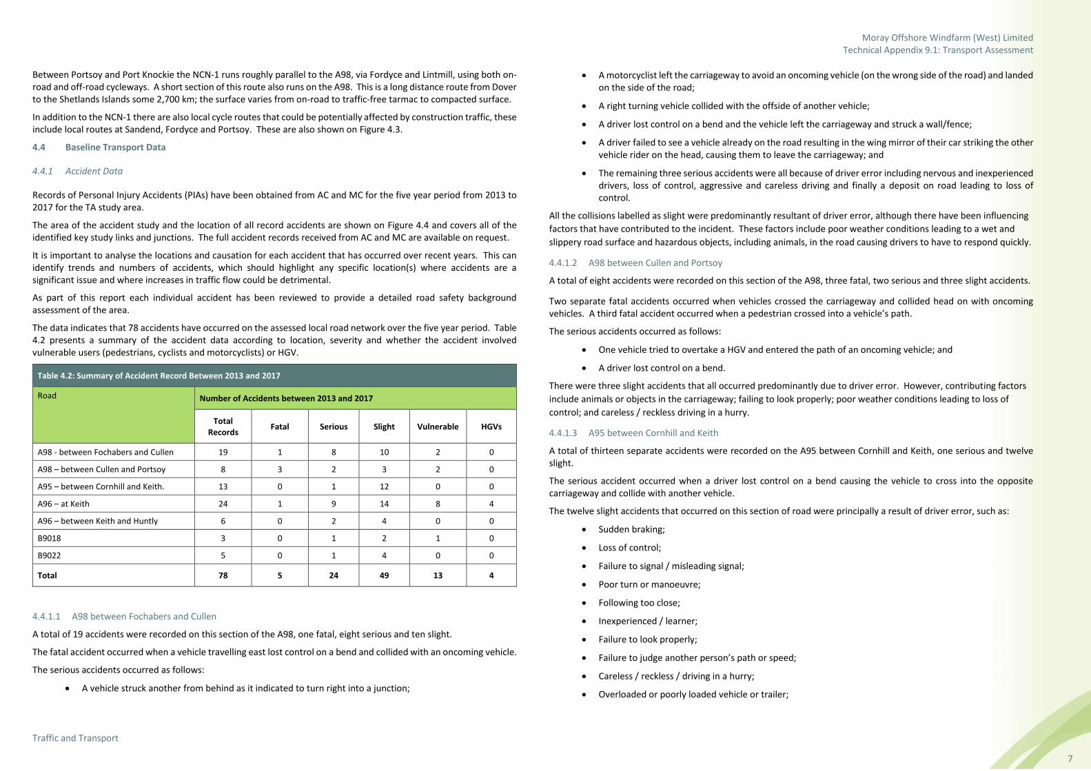
Records of Personal Injury Accidents (PIAs) have been obtained from AC and MC for the five year period from 2013 to 2017 for the TA study area.
The area of the accident study and the location of all record accidents are shown on Figure 4.4 and covers all of the identified key study links and junctions. The full accident records received from AC and MC are available on request.
It is important to analyse the locations and causation for each accident that has occurred over recent years. This can identify trends and numbers of accidents, which should highlight any specific location(s) where accidents are a significant issue and where increases in traffic flow could be detrimental.
As part of this report each individual accident has been reviewed to provide a detailed road safety background assessment of the area.
The data indicates that 78 accidents have occurred on the assessed local road network over the five year period. Table 4.2 presents a summary of the accident data according to location, severity and whether the accident involved vulnerable users (pedestrians, cyclists and motorcyclists) or HGV.
Table 4.2: Summary of Accident Record Between 2013 and 2017
Road Number of Accidents between 2013 and 2017
Total Records
Fatal Serious Slight Vulnerable HGVs
A98 - between Fochabers and Cullen 19 1 8 10 2 0
A98 – between Cullen and Portsoy 8 3 2 3 2 0
A95 – between Cornhill and Keith. 13 0 1 12 0 0
A96 – at Keith 24 1 9 14 8 4
A96 – between Keith and Huntly 6 0 2 4 0 0
B9018 3 0 1 2 1 0
B9022 5 0 1 4 0 0
Total 78 5 24 49 13 4
4.4.1.1 A98 between Fochabers and Cullen
A total of 19 accidents were recorded on this section of the A98, one fatal, eight serious and ten slight.
The fatal accident occurred when a vehicle travelling east lost control on a bend and collided with an oncoming vehicle.
The serious accidents occurred as follows:
• A vehicle struck another from behind as it indicated to turn right into a junction;
• A motorcyclist left the carriageway to avoid an oncoming vehicle (on the wrong side of the road) and landed on the side of the road;
• A right turning vehicle collided with the offside of another vehicle;
• A driver lost control on a bend and the vehicle left the carriageway and struck a wall/fence;
• A driver failed to see a vehicle already on the road resulting in the wing mirror of their car striking the other vehicle rider on the head, causing them to leave the carriageway; and
• The remaining three serious accidents were all because of driver error including nervous and inexperienced drivers, loss of control, aggressive and careless driving and finally a deposit on road leading to loss of control.
All the collisions labelled as slight were predominantly resultant of driver error, although there have been influencing
factors that have contributed to the incident. These factors include poor weather conditions leading to a wet and
slippery road surface and hazardous objects, including animals, in the road causing drivers to have to respond quickly.
4.4.1.2 A98 between Cullen and Portsoy
A total of eight accidents were recorded on this section of the A98, three fatal, two serious and three slight accidents.
Two separate fatal accidents occurred when vehicles crossed the carriageway and collided head on with oncoming vehicles. A third fatal accident occurred when a pedestrian crossed into a vehicle’s path.
The serious accidents occurred as follows:
• One vehicle tried to overtake a HGV and entered the path of an oncoming vehicle; and
• A driver lost control on a bend.
There were three slight accidents that all occurred predominantly due to driver error. However, contributing factors
include animals or objects in the carriageway; failing to look properly; poor weather conditions leading to loss of
control; and careless / reckless driving in a hurry.
4.4.1.3 A95 between Cornhill and Keith
A total of thirteen separate accidents were recorded on the A95 between Cornhill and Keith, one serious and twelve slight.
The serious accident occurred when a driver lost control on a bend causing the vehicle to cross into the opposite carriageway and collide with another vehicle.
The twelve slight accidents that occurred on this section of road were principally a result of driver error, such as:
• Sudden braking;
• Loss of control;
• Failure to signal / misleading signal;
• Poor turn or manoeuvre;
• Following too close;
• Inexperienced / learner;
• Failure to look properly;
• Failure to judge another person’s path or speed;
• Careless / reckless / driving in a hurry;
• Overloaded or poorly loaded vehicle or trailer;

Moray Offshore Windfarm (West) Limited Technical Appendix 9.1: Transport Assessment
Traffic and Transport
8
• Failure to adapt to the conditions; and
• Disobeyed give way or stop signs or markings.
4.4.1.4 A96 at Keith
A total of 24 separate accidents were recorded on this section of the A96 at Keith. These included one fatal, nine serious and fourteen slight accidents.
The fatal accident occurred when the driver of a vehicle failed to see another vehicle ahead slowing and stopping, then subsequently collided directly into the rear of the other vehicle.
The serious accidents occurred as follows:
• A vehicle drifted across the road onto the opposing carriageway and collided with a pedestrian crossing the road;
• A driver lost control of a vehicle on a bend, clipping the verge and sending the vehicle into the opposite carriageway and into the path of an oncoming vehicle;
• A HGV collided with a vehicle waiting to turn right, resulting in the waiting vehicle colliding with the stone parapet of a bridge;
• A pedestrian stepped off a pedestrian island into the path of an oncoming vehicle;
• The second of two motorcyclists riding separate bikes fell at a junction, the first rider observed this in their rear view mirror, over corrected their bike and fell also;
• A driver mounted the nearside soft verge, over corrected, crossed both lanes and passed down an embankment;
• The driver of a parked van failed to observe a pedestrian standing behind it and reversed into them; and
• Two separate incidents where a pedestrian ran into the path of an oncoming vehicle.
There were also fourteen slight accidents recorded on the A96 through Keith that can mostly be attributed to driver and pedestrian error including failure to look; failure to judge speed and path of others; following too close; travelling too fast for conditions; sudden braking; exceeding speed limit; loss of control; distraction in vehicle; inexperience; illegal turn or direction of travel; illness (physical or mental); fatigue; and driving in a careless / reckless manner.
4.4.1.5 A96 between Keith and Huntly
A total of six accidents were recorded on this section of the A96 between Keith and Huntly, two were serious and four slight.
A serious accident occurred when a driver crossed into the opposing carriageway before rolling down an embankment.
The second serious accident occurred when a vehicle failed to notice that the vehicle in front had slowed down, resulting in a collision.
The four slight accidents that occurred within this section were due to driver error, such as a poor turn or manoeuvre; careless / reckless driving; sudden braking; loss of control; failure to judge the path or speed of another individual; and failure to adapt to the conditions.
4.4.1.6 B9018
A total of three accidents were recorded on the B9018, consisting of one serious and two slight accidents. The serious accident occurred when a vehicle failed to slow down on approaching two horse riders, startling the horses, and dismounting the rider.
The two slight accidents, details are unknown however it is considered that driver error is the principal cause of the collisions.
4.4.1.7 B9022
A total of five accident were recorded on the B9022 one of which was serious and four were slight accidents.
The serious accident occurred when a vehicle collided with the road verge, left the carriageway, rolled down an embankment and collided with a tree.
The four slight accidents that occurred on this stretch of road were as a result of driver error and failure to adapt to the conditions.
4.4.2 Summary
The analysis above indicate that there were numerous accidents across the network over the last 5 years. It is considered that these accidents are within normal parameters for trunk, A and B roads and assessment of the clusters of accidents on these links has shown that driver error is the predominate cause of accidents. No clusters of accidents involving vulnerable road users were identified on these routes.
In summary, the accident assessments set out above do not indicate any locations where accidents may be made worse by the OnTI traffic. All development traffic will be routed to site, and instructions given on how to drive through the local area as set out in the PCTMP.
Overall there are no trends suggesting that the temporary construction traffic from the proposed OnTI will have an impact on road safety.
4.5 Traffic Counts
As part of the development of the TA, and to understand the existing traffic conditions within the TA study area, Wood commissioned Nationwide Data Collection to undertake a series of Automatic Traffic Counts (ATC). A random week was chosen during school term time for the survey and this resulted in a start date of Thursday 23 November 2017 and an end date of Wednesday 29 November 2017.
Figure 4.5 shows the location of these traffic counts as follows:
• Site 1 – A98 south of Buckie and west of the A98 / A942 junction;
• Site 2 – A98 Seafield Street in Cullen, south of The Square and Reidhaven Street;
• Site 3 – B9018 within Lintmill,;
• Site 4 – A98 south of Sandend and east of Seaview Road;
• Site 5 – A98 Seafield Street in Portsoy between Burnside Street and Shillinghill;
• Site 6 – B9022 between Portsoy and Gordonstown, immediately south of Longmuir farm;
• Site 7 – B9018 at Deskford;
• Site 8 – B9018 south of the Grange Crossroads;
• Site 9 – A95 between Drumnagorrach and Limehillock;
• Site 10 – A95 east of the B9018 / A95 junction;
• Site 11 – A96 Moss Street in Keith, south of Union Terrace;
• Site 12 – A96 between Keith and Fochabers;
• Site 13 – A95 between Keith and Mulben; and
• Site 14 – A96 east of the B9115 / A96 junction at Edintore.
The ATC for site 4 was resurveyed between Friday 01 December 2017 and Thursday 07 December 2017 as the original count was unavailable for interpretation.
Moray Offshore Windfarm (West) Limited Technical Appendix 9.1: Transport Assessment
Traffic and Transport
9
This information provides base network flows which have been used to inform the calculation of future year traffic flows. Figures 4.6 presents a network plot of the 2017 base year surveyed daily traffic flows.
Details of the traffic count data can be provided on request.
5. Summary of Development Proposals and Access Requirements
5.1 The Proposed Development
The OnTI will connect the proposed Moray West Offshore Wind Farm and associated Offshore Transmission Infrastructure (OfTI) to the existing Blackhillock substation approximately 1.5 km south of Keith.
The main components of the project will include:
• Up to two offshore export cables (between MLWS and the transition joint bays only);
• Transition joint bays (the interface between the offshore export cables and onshore cable circuits) at the Onshore Landfall Area;
• Up to two onshore underground cable circuits; approximately 29 km of underground cable circuits between the transition joint bays and a new onshore substation;
• Onshore substation (required to transform the electricity before feeding it into the NETS at the existing Blackhillock substation);
• Buried onshore cable circuits connecting the new onshore substation to the existing Blackhillock substation;
• Permanent access rights to underground cable circuits; and
• Temporary access roads, storage / laydown areas, and construction compounds (one main compound and three satellite compounds).
5.2 Key Transport Implications
In terms of the TA, there are three distinct elements of the OnTI to consider:
• The Onshore Landfall Area;
• The underground cable circuits; and
• The onshore substation.
The TA sets out the proposed construction methodology and the implications this has for traffic and transport. In summary, typical construction plant and vehicles include:
• JCB-type excavator to dig the trenches;
• Support vehicle (HIAB) to deliver materials;
• Vans and 4x4 vehicles used by workers travelling to the site;
• Other one off vehicles for specific construction periods (for example cable drum vehicles for pulling the conductor wires);
• HGV and HIAB for delivery of some plant and materials to the individual sites; and
• AIL and HGV for delivery of plant and material to the main compound.
It is estimated that a majority of the trips generated by the OnTI in the construction period will be related to the plant and vehicles set out above, however, there will be a need for some other ‘one off’ vehicles such as AIL, cable drum vehicles and cranes.
The construction method for the cable circuits will mainly be open cut trenching. However, Horizontal Directional Drilling (HDD) will be used to pass the cable circuits under significant features such as the River Isla and main roads.
The estimated overall construction duration of the OnTI is approximately 30 months. As a basis of assessment, a 30 month programme has been used starting in week one commencing April 2022 and running to the end of September 2024.

Moray Offshore Windfarm (West) Limited Technical Appendix 9.1: Transport Assessment
Traffic and Transport
10
Periodic inspection, maintenance and regular testing will be undertaken during the operational phase. These works are not expected to result in significant traffic or transport effects and have been scoped out of assessment in this TA. It is also proposed to scope out decommissioning of the OnTI as this will be temporary and there will be fewer activities than during the construction phase as all subterranean assets and foundations will be left in situ. As such this TA is focused on the construction period alone.
5.3 Access Overview
This section of the TA sets out indicative locations for the accesses for the OnTI.
Vehicular access is required to construct the various elements of the OnTI. This is proposed to be via seven indicative access locations along the length of the route. These accesses are varied in location, type, nature and size.
Figure 1.1 shows the indicative access numbers for reference.
Table 5.1 following, sets out the seven indicative accesses, including details such as:
• Designated access number;
• Indicative Ordinance Surveys (OS) Grid Reference;
• Classification of road access is onto; and
• Whether the access is existing or not?
Table 5.1: Indicative Accesses
Access Indicative OS Grid Reference Road to Access Existing Access?
1 NJ 55704 65586 A98 No
2 NJ 49125 57430 B9018 No
3 NJ 49007 56013 B9018 No
4 NJ 48086 54485 Gallowhill Terrace No
5 NJ 46949 53104 B9018 No
6 NJ 47191 51826 A95 No
7 NJ 44615 46163 A96 Yes
Table 5.1 sets out indicative locations of all the accesses, only one is existing and six are onto A or B classification road.
5.4 Requirement for New Temporary Construction Accesses
As set out in Table 5.1, there are six indicative locations where new accesses will be required (access reference numbers 1 to 6) and one indicative location where improvements maybe necessary (access reference number 7).
All six new indicative accesses that are required are because no suitable formal access onto the road network exists at these locations.
Accesses 2 to 6, new temporary construction accesses are all proposed to access the AC and MC road network and as such consultation with both authorities should be undertaken to agree the requirements for these accesses. Temporary construction accesses 1 and 7, will fall under Transport Scotland’s jurisdiction and as such consultation should be undertaken with them. With low traffic numbers predicted at the access locations, it is considered that the accesses should be provided according to the specifications shown in the Design Manual for Roads and Bridges (DMRB) TD41/95 for a field access standard as shown in Image 5.1.
Image 5.1 DMRB Field Access Layout Specification
5.5 Management of Accesses
It is important to set out how the accesses will be managed to ensure these operate in a safe manner, once the accesses have been constructed or any necessary improvements completed, they will be managed in one of three ways:
• Traffic management (via signals or banksmen);
• Use of access as is with just traffic signage implemented; and
• Additional improvements to visibility splays.
A PCTMP has been prepared to support this TA and sets out the proposals for managing access to the sites safely and efficiently.
5.5.1 Visibility Improvements
It is likely that all visibility requirements on the higher speed A and B roads will be met. However, through discussion it may be possible to provide Access 4 with sub-standard visibility if a different approach to traffic management is implemented.
5.6 Assessment Sections
With the number and the possible locations of the access points known, the OnTI is separated into sections for
programming and trip generating purposes as follows:
• Onshore Landfall Area;
• Section 1 – Between the Onshore Landfall Area and the A98;
• Section 2 – Between the A98 and Access 3 near Burnend;
• Section 3 – Between Access 3 and Access 4 near Grange Crossroads;
• Section 4 – Between Access 4 and the A95;

Moray Offshore Windfarm (West) Limited Technical Appendix 9.1: Transport Assessment
Traffic and Transport
11
• Section 5 – Between the A95 and the River Isla;
• Section 6 – Between the River Isla and the onshore substation site;
• Onshore substation site; and
• Section 7 – Between the onshore substation site and Blackhillock substation.
For the purposes of assessment, the PCTMP and the EIA Report, it has been necessary to make assumptions as to the locations of the construction compounds in order to estimate traffic flows across the road network. These assumptions are indicative only. Final locations for the construction compounds will not be determined until the detailed design and planning processes are complete. For the assessment it has been assumed that the following indicative relationships between the accesses, compounds and sections exist.
Table 5.2: Indicative Relationship Between Accesses, Compounds and Sections
Access Serving Compound Serving Section
1 Satellite compound 1 Landfall, 1 and 2 (north)
2 Satellite compound 2 3
3 2 (south) and 3 (north)
4 3 (south) and 4 (north)
5 Satellite compound 3 4 and 5
6 4 (south) and 5
7 Main compound 6, substation and 7
6. Development of Traffic Generation and Distribution
6.1 Introduction
This chapter establishes the methodology for the generation of the traffic flows that are predicted to be associated with the construction of the OnTI. The construction methodology is based on two key sources of information:
• The proposed construction programme; and
• Previous experience of working with construction traffic generation for similar developments.
Previous experience has been used to understand the nature, type, size and likely numbers of differing vehicle types likely to be required on the OnTI. Details from the preceding chapters have been brought together and a breakdown of the anticipated traffic generation for the OnTI has been generated. However, as detailed design of the OnTI is yet to occur, and as construction methodologies and technologies generally improve over time, the assumptions made within this assessment are considered to represent a worst case solution.
6.2 Traffic Flow Generation Methodology
Details of each construction activity are set out below, including the assumptions and calculations that have been made in order to identify the resultant traffic generation.
Informed by the construction programme, the traffic generation is presented in chapter 6.3 as weekly traffic flows.
To provide a meaningful estimate of traffic flows, the construction programme has been split into distinctive elements, which are as follows:
• Construction at the Onshore Landfall Area;
• Construction compound works;
• Cable circuits haul route;
• Cable circuits materials deliveries;
• Cable circuits hedgerow translocation;
• Underground civil works;
• Cable circuits installation;
• Onshore substation construction;
• Energise; and
• Reinstate.
There are two elements of the programme that will not generate any traffic:
• Cable circuits hedgerow translocation – This will involve translocating hedgerows along the route for the cable circuits. This will be done using existing plant onsite and no hedges will be translocated outside of the works sites; and
• Energising the connection – This will be the phase where the OnTI is energised and will not result in any significant traffic flows.
There is also a requirement for temporary security staff at the compounds once established until they are dismantled. The traffic generated by this is set out in further details below.
For reference in the section below ‘x two-way vehicle / construction movements’ refers to the total vehicles. For example, 20 two-way vehicle movements is 10 inbound trips and 10 outbound trips.

Moray Offshore Windfarm (West) Limited Technical Appendix 9.1: Transport Assessment
Traffic and Transport
12
6.2.1 Onshore Landfall Area Construction
Construction at the Onshore Landfall Area is anticipated to take some five months and may include the construction of a cofferdam to enable a connection with the offshore export cables. If a coffer dam is required, sheet piles, concrete blocks, concrete and sand will be needed along with general construction materials and plant.
It is anticipated that there will be some 1,180 two-way construction movements (590 inbound and 590 outbound) associated with the landfall and it is assumed that the peak will be during the first month in the setup phase. Of the 1,180 two-way construction movements some 730 two-way movements (365 inbound and 365 outbound) will be staff vehicle movements.
The programme presented in Figure 6.1 shows the anticipated number of vehicle trips per week over the five month construction period.
6.2.2 Construction Compound Works
The establishment of the main compound and the three satellite compounds are assumed as a worst case to generate the same number of trips. Experience suggests that a hardstanding of up to 10,000 sqm may be required which will be stone at a depth of 0.3 m. In practice the satellite compounds may only need to be some 4,900 sqm in area. This results in a requirement for 63 HGV direct to site and one crane inbound and 63 HGV and one crane outbound, therefore resulting 128 HGV two-way movements.
It is anticipated that 56 two-way staff vehicle movements (26 inbound and 26 outbound) will be required to construct each of the compounds and in addition, there will be a requirement for permanently staffing each of the compound locations for security.
It is likely that three members of permanent staff will be required at each compound during its life, resulting in six two-way staff vehicle movements (three inbound and three outbound) per day, seven days a week.
Figure 6.2 sets out the traffic flows calculated for this element of the construction programme across 18 months of the programme.
6.2.3 Cable Circuits Haul Route Construction
The fully fenced haul route is anticipated to be some 5.5 m wide with a depth of 0.3 m along the entire length of the cable route which equates to approximately 92,530 tonne of stone. Assuming this is delivered in approximately 20 tonne capacity HGV direct to site, a total of 4,649 HGV deliveries or 9,298 HGV two-way movements will be required.
It has been assumed that the fencing will be delivered via the relevant compound in 12 HGV vehicles per week throughout the construction of the haul route. This results in 1,404 two-way HGV movements (702 inbound and 702 outbound) once trips to and from the compound are added to those to and from the supplier. It is anticipated that there will be a total of 840 two-way movements between the supplier and the compound and 564 two-way movements between the compounds and the site.
It has been assumed for the purpose of this assessment that two teams will be engaged in the construction of the haul route and together it is anticipated that they could construct 160 m per day. This results in the construction of the haul route taking 35 weeks.
Figure 6.2 sets out the traffic flows calculated for this element of the construction programme across 18 months of the programme.
6.2.4 Cable Circuits Materials Deliveries
This element of the construction programme is related to the delivery of materials required for the completion of the cable circuits. There are three main elements that are required to be delivered to the compounds:
• Cable ducts;
• Sand and limestone dust; and
• Cables.
For the purpose of this assessment it has been assumed that the each of the three cables within the circuit will be delivered individually and will each require a separate duct. This assumption has been made as it is considered to be a worst case scenario.
There is a requirement for approximately 175 km of cable ducts. Each duct is 6 m in length and this leads to a requirement for approximately 29,206 ducts in total. Each HGV can transport 468 ducts and as such there is a requirement for 63 duct deliveries via the relevant compound and this results in 234 two-way HGV movements (117 inbound and 117 outbound) once trips to and from the compound are added to those to and from the supplier. It is anticipated that there will be a total of 124 two-way movements between the supplier and the compound and 110 two-way movements between the compounds and the site.
There may be a requirement for approximately 67,290 tonnes of sand to support the cable ducts over the length of underground cable. Assuming this is delivered in 20 tonne capacity HGV, a total of 3,365 HGV deliveries via the relevant compound and this results in 11,188 two-way HGV movements (5,594 inbound and 5,594 outbound) once trips to and from the compound are added to those to and from the supplier. It is anticipated that there will be a total of 6,730 two-way movements between the supplier and the compound and 4,458 two-way movements between the compounds and the site.
There is a requirement for approximately 175 km of cable. As 1.5 km of cable comes on a drum and each HGV can carry three drums it can be calculated that there is a requirement for some 39 HGV deliveries via the relevant compound and this results in 164 two-way HGV movements (82 inbound and 82 outbound) once trips to and from the compound are added to those to and from the supplier. It is anticipated that there will be a total of 78 two-way movements between the supplier and the compound and 86 two-way movements between the compounds and the site.
It has been assumed for the purpose of this assessment that the civil works and cable circuit installation could be undertaken at a rate of 300 m per day. Consequently, the construction of the civil works and cable circuit installation will take 20 weeks and as a result the material deliveries could be expected over this timeframe too.
Figure 6.2 sets out the traffic flows calculated for this element of the construction programme across 18 months of the programme.
6.2.5 Cable Circuits Civil Works and Installation
This element of the construction programme encompasses various civil engineering tasks required to enable the cable to be installed, as follows:
• Construction of joint bays, including concrete deliveries; and
• General underground civil works such as trench digging and other cable works.
Each joint bay will require 11 deliveries (22 HGV two-way movements) of concrete which are assumed to arrive direct from local suppliers plus four ancillary HGV deliveries per day. There are potentially 76 joint bays required which will be accessed via the haul route and identified accesses and as such 1,218 HGV deliveries or 2,436 two-way total HGV movements will be generated.
As noted above, it has been assumed for the purpose of this assessment that one team will be engaged in the construction and laying of the cable circuits and it is anticipated that they could construct 300 m per day resulting in a 20 week construction period.
Figure 6.2 sets out the traffic flows calculated for this element of the construction programme across 18 months of the programme.
6.2.6 Horizontal Directional Drilling
For the purposes of the assessment, HDD is proposed to take place at the:
• Onshore Landfall Area;
• A98;

Moray Offshore Windfarm (West) Limited Technical Appendix 9.1: Transport Assessment
Traffic and Transport
13
• A95;
• River Isla and railway track;
• A96; plus
• Up to nine other unidentified locations, such as sensitive watercourses.
Typically, each HDD site requires five staff per day for two weeks to undertake the work. This results in a total of eight LV two-way movements per day to the compound and two LV two-way movements per day between the compound and the site. In addition, the drilling will require ten equipment deliveries, all made by HGV (20 two-way HGV movements) and ten equipment removals (20 two-way HGV movements).
In the two northerly assessment sections, and the section to the south of the River Isla, it is proposed that two HDD teams will be deployed to meet the overall work programme of 20 weeks. In this instance, 10 staff per day will be required for two weeks, 40 two-way HGV movements will be required for equipment deliveries and 40 two-way movements will be required for equipment removals.
Over the course of the HDD works, this results in 480 two-way HGV movements (240 inbound and 240 outbound) for equipment removal and delivery, 1,408 two-way staff trips (704 inbound and 704 outbound) between the lodgings and compound and 288 two-way staff van trips (144 inbound and 144 outbound) between the compound and site.
Figure 6.2 sets out the traffic flows calculated for this element of the construction programme across all 18 months of the programme.
6.2.7 Cable Circuits Construction Staff
Experience from projects elsewhere has shown that up to 100 construction staff per day may be required in each phase of the works. For the purpose of this assessment it has been assumed that 100 construction staff will be present onsite each day as this represents a worst case scenario. It is anticipated that further staff will be required at the Onshore Landfall Area, and the onshore substation. In this geographical location is assumed that 63 staff cars (carrying 100 construction workers) will arrive at the relevant compound and depart for the works site in 20 vans every morning. The return journeys will be undertaken in the evening.
With the underground cable work expected to take just 18 months, this equates to 46,142 two-way staff trips (23,071 inbound and 23,017 outbound) between the lodgings and compound and 14,892 two-way staff van trips (7,446 inbound and 7,446 outbound) between the relevant compound and works site.
6.2.8 Underground Civil Works and Compound to Site Materials Deliveries
It is noted above that the deliveries for the construction of the compounds, joint bays, haul route and HDD will all occur direct from a local supplier to the site and vice versa in the case of reinstatement / removal.
All other activities are assumed to utilise the closest compound in order to store large quantities of materials prior to their use onsite. This method of construction results in the generation of additional vehicle trips between compound and site and as such additional trips are included within the relevant activity column of Figure 6.2 across all 18 months of the programme.
6.2.9 Reinstatement Works
The works for the reinstatement of the construction areas will be the reverse of the access accommodation works and this includes the ‘worst case’ assumption that all stone required on the project is removed from site.
Figure 6.2 sets out the traffic flows calculated for this element of the construction programme across all 18 months of the programme.
6.2.10 Onshore Substation Construction
It is envisaged that the construction of the substation will take some 23 months to complete and will include the following features necessary to accommodate the various electrical switchgear and transformers:
• Buildings;
• Hard standing;
• Access roads; and
• Concrete pad foundations.
These features will need, concrete, cabling sands, rock, prefabricated building sections and general construction supplies for their construction. AIL vehicles will be needed to transport the transformers and reactors to site along with specialist cranes to position them within the onshore substation compound.
It is anticipated that there will be some 169,112 two-way construction movements (84,556 inbound and 84,556 outbound) associated with the construction of the substation and it is assumed that the peak will be when the foundations are being laid four months after construction starts. Of the 169,112 two-way construction movements it has been estimated that some 165,000 two-way movements will be staff vehicles (82,500 inbound and 82,500 outbound) generated by 250 construction staff present on site each day. This assumption represents a worst case scenario.
Figure 6.3 sets out the traffic flows calculated for this element of the construction programme across all 23 months of the programme.
6.3 Traffic Generation Summary
With all the elements above having had traffic generation calculated independently as set out in Figures 6.1, 6.2 and 6.3, this traffic can be amalgamated to understand the overall impact on each road link during various times throughout the construction programme.
Image 6.1 presents a plot of the anticipated construction vehicle movements (both total vehicles and HGV) across each week of the construction programme. The plot shows a fairly constant low level traffic generation for the first year of the programme when the landfall and substation are being constructed. At the beginning of the second year the construction traffic significantly increases as the preparation works for the cable circuits begins. The peak period occurs when the onshore substation construction is nearing completion, the preparation works for the cable circuits are ongoing and the civil works and cable laying commence. The final period relates to the removal of temporary infrastructure and reinstatement.

Moray Offshore Windfarm (West) Limited Technical Appendix 9.1: Transport Assessment
Traffic and Transport
14
Image 6.1: Construction Vehicle Movements by Week
Three weeks have been identified when the combined traffic flows across the TA study area network will be at their highest. These weeks occur during the third quarter of construction.
Week 76 occurs during Q3 2023:
• The installation phase at the onshore substation;
• Construction of the haul route just north of the A95; and
• Underground civil works, cable circuit installation and HDD near Deskford.
During this week, some 4,088 two-way construction vehicle movements are anticipated and of this, some 1,278 two-way HGV movements could be expected across the TA study area network. Whilst these vehicle movements present the peak week, a similar (if slightly lower) volume of construction traffic could be expected for six weeks afterwards.
Week 80 occurs during Q4 2023:
• The installation phase at the onshore substation;
• Construction of the haul route north of the A96; and
• Underground civil works, cable circuit installation and HDD near Crannock.
During this week, some 4,094 two-way construction vehicle movements are anticipated and of this, some 1,266 two-way HGV movements could be expected across the TA study area network. Whilst these vehicle movements present the peak week, a similar (if slightly lower) volume of construction traffic could be expected for four weeks before and two weeks afterwards.
Week 85 occurs during Q4 2023:
• The commissioning phase of the onshore substation;
• Construction of the haul route south of the River Isla; and
• Underground civil works, cable circuit installation and HDD south of the River Isla.
During this week, some 4,000 two-way construction vehicle movements are anticipated and of this, some 1,188 two-way HGV movements could be expected across the TA study area network. These vehicle movements present the peak week on its own.
6.4 Trip Generation Sensitivity Test
As a sensitivity test, a 24 month construction period has been considered where the onshore cable circuit works commence immediately after the construction of the Onshore Landfall Area. If this were to occur then the number of vehicle movements per day during the most intensive working week would increase from 744 vehicle movements per day to 746 vehicle movements per day across the whole study area. It is considered that this change is negligible and therefore the analysis that follows remains valid.
6.5 Traffic Distribution
Many of the individual movements set out above will have start and destination points known (once detailed design of the OnTI has been completed), for example it will be known that deliveries from a compound to an access have a defined route. The remaining trips have as a minimum a defined end point (construction access). It is therefore possible to control the routes that are taken by any vehicle wishing to access the OnTI. However, there are many other assumptions that have been made for other delivery routes and staff routes that have yet to be established but which could affect parts of the local road network. These are set out in further detail below:
• Concrete, stone, sand and limestone dust will be sourced from a local quarry, for the purpose of this TA only it is assumed to be Breedon Boyne Bay Quarry, east of Portsoy which will access the TA study area via the A98 (east);
• All other materials and plant are assumed (for the purpose of this TA only) to be sourced from Elgin and the surrounds, and as such will access the TA study area via the A96 (west);
• All staff are anticipated to source lodgings west of the TA study area and as a result will also access the TA study area from the A96 (west); and
• It has been assumed that all materials, plant and staff for both the landfall and substation sites will arrive at site 50 % from the east via the A98 and 50 % from the west via the A96.
In reaching the assumptions it is relevant to note that the methodology set out does not take into account every trip on the network nor is it feasible at this stage to calculate this. As this is an anticipated programme and no main contractor is in place, it is not possible to calculate all the detailed inter access trips that might be generated depending on how work is actually progressed.
However, the assessment has taken a realistic worst case approach to a number of matters relating to traffic generation and as such it is considered that the numbers presented are a robust estimate of the likely traffic generation on the local roads network.
This distribution has been applied to the traffic generation for the OnTI and the impacts of this on the local roads network are considered in Chapter 8.
6.6 Traffic Routes to Site
With the distribution assumptions set out above, an estimation of the potential routes to site has been made. The PCTMP sets out all the factors that have been considered when developing the routes as this is based on a number of factors.
The routes to each identified access have been selected as they minimise the impacts of construction activities upon local residents and businesses. Construction traffic should use the main A roads as far as possible before routing onto B, C and U classification roads. The routeing strategy aims to minimise the effect on the road network by selecting the shortest routes from the access onto the national road network.
The routes proposed are presented in Figure 6.4.
0
500
1000
1500
2000
2500
3000
3500
4000
4500
1 5 9
13
17
21
25
29
33
37
41
45
49
53
57
61
65
69
73
77
81
85
89
93
97
10
1
10
5
10
9
11
3
11
7
12
1
12
5
12
9
Veh
icle
Mo
vem
ents
Week
Total Vehicle Movements HGV Movements

Moray Offshore Windfarm (West) Limited Technical Appendix 9.1: Transport Assessment
Traffic and Transport
15
6.7 Construction Traffic Flows
Figures 6.5, 6.6 and 6.7 present the anticipated weekly construction traffic flows from weeks 76, 80 and 85 respectively assigned to the local road network within the TA study area.
7. Traffic Growth and Cumulative Developments
7.1 Background Traffic Growth
To understand the traffic impact in future years, background traffic growth needs to be calculated.
Levels of background traffic growth are variable, dependent upon the predicted increase in economic activity within the area. The growth rate has been developed based on the National Trip End Model (NTEM) growth rates extracted from the DfTs Trip End Model Presentation Program TEMPRO 7.2 for Moray.
2023 is the most appropriate year of assessment as it is when the highest levels of construction traffic will be on the network. The growth factor for light vehicles between 2017 and 2023 is 1.0528.
The traffic impact during the operational phase is regarded as negligible and it is considered that the decommissioning impact of the OnTI will be lower in percentage terms than the construction phase, in part because background traffic will be significantly higher in say 25 years. It is on this basis that the assessment has focused upon the construction phase only.
7.2 Cumulative Assessment and Committed Developments
During the consultation process with AC and MC, it was noted that there are two other proposed developments within 5 km of the PAB, the potential effects of which could be significant when considered cumulatively with those of the OnTI. The proposed developments are Aultmore Wind Energy Project and Lurg Hill Wind Farm. Neither development will be permanently staffed during operation; it is therefore considered that the potential for cumulative traffic and transport effects to arise in combination with the OnTI will be during construction only.
A review of the Environmental Statements for both proposed developments reveals that their construction start dates are unknown at the stage and therefore an accurate assessment of cumulative effects is not possible. However, a summary of their potential construction traffic generation is provided in Table 7.1.
Table 7.1: Other Proposed Developments within 5 km of the PAB
Development Construction Duration
Peak Day Flows (Total Vehicles) Peak Day Flows (HGV)
Aultmore Wind Energy Project.
10 months. 37 total vehicle trips per weekday. 31 HGV trips per weekday.
Lurg Hill Wind Farm. 6 months. 81 vehicle trips per weekday. 69 HGV trips per weekday.
TOTAL 118 total vehicle trips per weekday. 100 HGV trips per weekday.
While there is potential for cumulative effects to occur, in the event that the OnTI is constructed at the same time as the other proposed developments, it is considered improbable that the days of peak traffic flows will occur simultaneously since route options and peak delivery periods will vary.
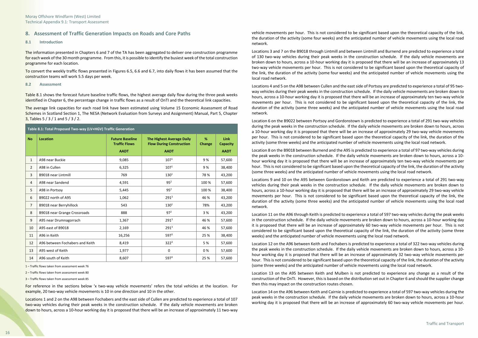
Moray Offshore Windfarm (West) Limited Technical Appendix 9.1: Transport Assessment
Traffic and Transport
16
8. Assessment of Traffic Generation Impacts on Roads and Core Paths
8.1 Introduction
The information presented in Chapters 6 and 7 of the TA has been aggregated to deliver one construction programme for each week of the 30 month programme. From this, it is possible to identify the busiest week of the total construction programme for each location.
To convert the weekly traffic flows presented in Figures 6.5, 6.6 and 6.7, into daily flows it has been assumed that the construction teams will work 5.5 days per week.
8.2 Assessment
Table 8.1 shows the forecast future baseline traffic flows, the highest average daily flow during the three peak weeks identified in Chapter 6, the percentage change in traffic flows as a result of OnTI and the theoretical link capacities.
The average link capacities for each road link have been estimated using Volume 15 Economic Assessment of Road Schemes in Scotland Section 1, The NESA (Network Evaluation from Surveys and Assignment) Manual, Part 5, Chapter 3, Tables 5 / 3 / 1 and 5 / 3 / 2.
Table 8.1: Total Proposed Two-way (LV+HGV) Traffic Generation
No Location Future Baseline Traffic Flows
AADT
The Highest Average Daily Flow During Construction
AADT
% Change
Link Capacity
AADT
1 A98 near Buckie 9,085 1071 9 % 57,600
2 A98 in Cullen 6,325 1071 9 % 38,400
3 B9018 near Lintmill 769 1301 78 % 43,200
4 A98 near Sandend 4,591 952 100 % 57,600
5 A98 in Portsoy 5,445 952 100 % 38,400
6 B9022 north of A95 1,062 2913 46 % 43,200
7 B9018 near Berryhillock 543 1301 78% 43,200
8 B9018 near Grange Crossroads 888 972 3 % 43,200
9 A95 near Drumnagorrach 1,367 2913 46 % 57,600
10 A95 east of B9018 2,169 2913 46 % 57,600
11 A96 in Keith 16,256 5973 25 % 38,400
12 A96 between Fochabers and Keith 8,419 3223 5 % 57,600
13 A95 west of Keith 1,977 0 0 % 57,600
14 A96 south of Keith 8,607 5973 25 % 57,600
1 – Traffic flows taken from assessment week 76
2 – Traffic flows taken from assessment week 80
3 – Traffic flows taken from assessment week 85
For reference in the sections below ‘x two-way vehicle movements’ refers the total vehicles at the location. For example, 20 two-way vehicle movements is 10 in one direction and 10 in the other.
Locations 1 and 2 on the A98 between Fochabers and the east side of Cullen are predicted to experience a total of 107 two-way vehicles during their peak weeks in the construction schedule. If the daily vehicle movements are broken down to hours, across a 10-hour working day it is proposed that there will be an increase of approximately 11 two-way
vehicle movements per hour. This is not considered to be significant based upon the theoretical capacity of the link, the duration of the activity (some four weeks) and the anticipated number of vehicle movements using the local road network.
Locations 3 and 7 on the B9018 through Lintmill and between Lintmill and Burnend are predicted to experience a total of 130 two-way vehicles during their peak weeks in the construction schedule. If the daily vehicle movements are broken down to hours, across a 10-hour working day it is proposed that there will be an increase of approximately 13 two-way vehicle movements per hour. This is not considered to be significant based upon the theoretical capacity of the link, the duration of the activity (some four weeks) and the anticipated number of vehicle movements using the local road network.
Locations 4 and 5 on the A98 between Cullen and the east side of Portsoy are predicted to experience a total of 95 two-way vehicles during their peak weeks in the construction schedule. If the daily vehicle movements are broken down to hours, across a 10-hour working day it is proposed that there will be an increase of approximately ten two-way vehicle movements per hour. This is not considered to be significant based upon the theoretical capacity of the link, the duration of the activity (some three weeks) and the anticipated number of vehicle movements using the local road network.
Location 6 on the B9022 between Portsoy and Gordonstown is predicted to experience a total of 291 two-way vehicles during the peak weeks in the construction schedule. If the daily vehicle movements are broken down to hours, across a 10-hour working day it is proposed that there will be an increase of approximately 29 two-way vehicle movements per hour. This is not considered to be significant based upon the theoretical capacity of the link, the duration of the activity (some three weeks) and the anticipated number of vehicle movements using the local road network.
Location 8 on the B9018 between Burnend and the A95 is predicted to experience a total of 97 two-way vehicles during the peak weeks in the construction schedule. If the daily vehicle movements are broken down to hours, across a 10-hour working day it is proposed that there will be an increase of approximately ten two-way vehicle movements per hour. This is not considered to be significant based upon the theoretical capacity of the link, the duration of the activity (some three weeks) and the anticipated number of vehicle movements using the local road network.
Locations 9 and 10 on the A95 between Gordonstown and Keith are predicted to experience a total of 291 two-way vehicles during their peak weeks in the construction schedule. If the daily vehicle movements are broken down to hours, across a 10-hour working day it is proposed that there will be an increase of approximately 29 two-way vehicle movements per hour. This is not considered to be significant based upon the theoretical capacity of the link, the duration of the activity (some three weeks) and the anticipated number of vehicle movements using the local road network.
Location 11 on the A96 through Keith is predicted to experience a total of 597 two-way vehicles during the peak weeks in the construction schedule. If the daily vehicle movements are broken down to hours, across a 10-hour working day it is proposed that there will be an increase of approximately 60 two-way vehicle movements per hour. This is not considered to be significant based upon the theoretical capacity of the link, the duration of the activity (some three weeks) and the anticipated number of vehicle movements using the local road network.
Location 12 on the A96 between Keith and Fochabers is predicted to experience a total of 322 two-way vehicles during the peak weeks in the construction schedule. If the daily vehicle movements are broken down to hours, across a 10-hour working day it is proposed that there will be an increase of approximately 32 two-way vehicle movements per hour. This is not considered to be significant based upon the theoretical capacity of the link, the duration of the activity (some three weeks) and the anticipated number of vehicle movements using the local road network.
Location 13 on the A95 between Keith and Mulben is not predicted to experience any change as a result of the construction of the OnTI. However, this is based on the distribution set out in Chapter 6 and should the supplier change then this may impact on the construction routes chosen.
Location 14 on the A96 between Keith and Cairnie is predicted to experience a total of 597 two-way vehicles during the peak weeks in the construction schedule. If the daily vehicle movements are broken down to hours, across a 10-hour working day it is proposed that there will be an increase of approximately 60 two-way vehicle movements per hour.

Moray Offshore Windfarm (West) Limited Technical Appendix 9.1: Transport Assessment
Traffic and Transport
17
This is not considered to be significant based upon the theoretical capacity of the link, the duration of the activity (some three weeks) and the anticipated number of vehicle movements using the local road network.
It should also be noted that the assessment above is for a 10 hour working day, when in all likelihood the working day may be up to 12 hours particularly during the summer months when daylight hours are longer.
Some of the percentage change figures presented in Table 8.1 will prompt an environmental assessment of these link and this is reported in Volume 2, Chapter 9: Traffic and Transport of the EIA Report.
8.3 Assessment Sensitivity Test
As a sensitivity test, the effect of the 60 additional construction vehicles per hour has been appraised. Using the traffic flows taken from the ATC survey data at Location 14 (where this change is anticipated) the percentage change can be calculated for the 10 hour working day. Table 8.2 presents this sensitivity test.
Table 8.2: Sensitivity Test at Location 14 (A96 between Keith and Carnie)
Hour 2017 Baseline Two-way Traffic Flows
2023 Future Baseline Two-way Traffic Flows
OnTI Traffic During Week 85
% Change
07:00-08:00 544 572 60 10.5 %
08:00-09:00 570 600 60 10.0 %
09:00-10:00 501 528 60 11.4 %
10:00-11:00 496 522 60 11.5 %
11:00-12:00 516 543 60 11.1 %
12:00-13:00 499 525 60 11.4 %
13:00-14:00 538 567 60 10.6 %
14:00-15:00 554 583 60 10.3 %
15:00-16:00 614 646 60 9.3 %
16:00-17:00 699 736 60 8.2 %
The result of the above test shows that the increase in traffic as a result of the OnTI construction is less than 12% during each hour of construction. Comparing the forecast future traffic flows on this link in the peak hour (706 vehicles per hour) with the estimated capacity of the link (2,400 vehicles per hour) it is considered that the capacity effects of the construction traffic are not significant.
8.4 Traffic Impact Summary
The assessments above set out that the impact on the local roads network when overall figures are broken down to days are not considered to have a significant effect.
It is considered that the increase in traffic flows predicted are not significant enough to delay bus services. However, should accesses be located in close proximity to existing bus stops then it may be prudent to temporarily relocate the bus stop to ensure any delays resulting from waiting turning vehicles do not impact upon the operations of the bus stop.
8.5 Core Path Management Strategy Summary
A management strategy is required to address the interactions between the core paths and the OnTI. A Framework Core Path Management Strategy (FCPMS) has been prepared and is included in the PCTMP.
The FCPMS identifies all the core paths that may be affected by the OnTI and then considers these individually before suggesting possible methodologies as to how these core paths could be managed.
The FCPMS has not identified any core paths that will be permanently affected. All core paths crossing the OnTI will, however, be affected for a short period of time.
The strategy considers the following management solutions to the core path crossings:
• Temporary re-routing of core paths (and associated closure) during construction of the OnTI;
• Provision of signage and other information alerting the public to construction works;
• Active management plan for crossing points for the core paths; and
• Active management plan for shared use access routes over the length of interaction with the core paths.
In addition to the case specific mitigation that will be required for the affected core paths, Moray West will undertake to inspect the core path routes impacted at the following times:
• Prior to construction;
• During the construction period; and
• Following completion.
A detailed onsite record (including photographs) will be produced to record the situation at each inspection point.
This will enable a baseline of the condition of the core paths to be made, to make sure that during construction no obstructions or impediments to using routes are created and to enable Moray West to reinstate the core paths to their previous condition once the construction period has ceased.
Offsite information will be provided at the main Council offices to inform local residents of works proposed. At the end of the construction phase all affected core paths will be inspected and their condition will be returned to the same as observed during the initial inspection. Moray West may consider the scope to improve the surface of some core paths and these will be identified in the initial survey.

Moray Offshore Windfarm (West) Limited Technical Appendix 9.1: Transport Assessment
Traffic and Transport
18
9. Summary of Preliminary Construction Traffic Management Plan
To support the TA a PCTMP has been prepared. The PCTMP details the proposals for minimising disruption to existing users on the public road network caused by construction of the OnTI. In common with the other documents prepared in support of the planning applications, operation and decommissioning impacts are not considered.
The PCTMP will be embedded within the eventual construction contractor documentation and will form an overarching and comprehensive management procedure for the contractor to adhere to. The PCTMP also includes a framework for managing the impacts on the core paths.
The PCTMP sets out the strategy and measures to be adopted in order to:
• Facilitate the site access points and routes for the delivery of construction materials and equipment;
• Provide temporary access routes within the site working areas;
• Manage the impacts arising from any temporary road closures that are required for various stages of the OnTI, including possible diversion routes where appropriate;
• Maintain communication with the local authorities and residents throughout construction activities; and
• Monitor the condition of the road surfaces.
It is intended that the PCTMP is a live document that will be updated and modified as agreed with the relevant road authorities as the OnTI progresses and as details are clarified during the detailed design and planning processes prior to the start of works onsite. The need to update the PCTMP is essential to reflect such things as other developments in the area that may have a cumulative effect on the public road network and the need to allow the eventual contractor flexibility in the way in which the connection is constructed.
The PCTMP must be submitted to and approved by the relevant planning authorities as a requirement of planning permissions. A statutory consultation process has been undertaken and consultation with AC, MC and Transport Scotland will continue. The OnTI shall be carried out in accordance with the PCTMP and Moray West will use all reasonable endeavours to ensure compliance with this document.
The PCTMP has set out a range of measures and methods for managing the impact of traffic resulting from the OnTI. Table 9.1 sets out the summary of the PCTMP.
Table 9.1: Measures Addressed / Acknowledged as Part of the PCTMP and Further Actions Required
Measure General Construction Traffic Further Actions
Delivery routes Required Contractor informed of approved HGV access routes in contract documentation.
Site access/management of junctions
Required As per PCTMP and TA.
AIL test run May be required. Possibly required, although it is a route used previously.
Vehicle escorts May be required Haulier will contact Police Scotland in due course to arrange vehicle escorts.
Route enforcement Required Standard contractor enforcement measures to be adopted
Road accommodation works (access)
Not Required. As per PCTMP. Temporary dismantling of street furniture will be carried out for AIL delivery.
Dilapidation surveys Required As PCTMP. Video surveys to be used at agreed locations with AC and MC to be focused on specific locations.
Coordination/ emergency contact
Required As per PCTMP and TA.
Route and access signage Required As per PCTMP and TA.
Table 9.1: Measures Addressed / Acknowledged as Part of the PCTMP and Further Actions Required
Measure General Construction Traffic Further Actions
Wheel cleaning/ street cleaning
Required As per PCTMP and TA.
Scaffolding May be required If required, as per PCTMP and TA.
Road closures May be required As per PCTMP. Diversion to be agreed with Transport Scotland, AC and MC.
Overhead lines and vegetation
Required As Per PCTMP and TA.
9.1 Travel Plan
9.1.1 Need for a Travel Plan
Local and national guidance sets out that, where traffic flow impacts are considered significant, a Travel Plan (TP) is required. TP are aimed at developing a sustainable travel pattern for employees and service users to access their place of work, residence or leisure. The establishment of a sustainable travel pattern is aimed at minimising the use of the private (normally single occupancy) car and their detrimental impacts upon the road network in terms of capacity and safety amongst other considerations.
For the OnTI, Moray West takes this issue seriously and in-built within the working practices and methodology for the construction activities are certain set principals. Therefore, a TP will be implemented which sets out many travel planning initiatives including:
• Travel planning awareness;
• Public transport;
• Car sharing;
• Modal shift monitoring;
• Travel Plan Coordinator (TPC); and
• Planned collections and deliveries to avoid unnecessary journeys.
These will be adopted to promote sustainable travel and minimise the impact upon the local road network.
9.1.2 Nature of Construction Activities
It is assumed for the purpose of this assessment that all staff will originate from outside of the Moray / Aberdeenshire area to ensure that a worst case scenario is assessed. Each team within a workforce generally consists of up to three people and has a van they will use to travel from the lodgings to site daily. Each team will travel to a compound every morning for a brief on the day’s operations, collection of materials required to complete the day’s tasks and to fulfil the health and safety requirements. The team will then travel to site from the local compound. Due to the working day being longer than a conventional working day, these trips are generally outside the normal peak hours.
At the end of the day each team will generally return to a compound for a debrief and check in. They will then return to the lodgings in the evening. This ensures that progress can be monitored, appropriate work can be planned for the subsequent days and that all health and safety requirements are completed.

Moray Offshore Windfarm (West) Limited Technical Appendix 9.1: Transport Assessment
Traffic and Transport
19
9.1.3 In-Built Sustainable Travel Practices
The use of construction teams traveling in vans means that single occupancy private vehicle travel associated with the OnTI will be kept to a minimum. Given the nature and rural location of the construction activities, it is considered that the methodology suggested provides for the most efficient and sustainable pattern.
9.1.4 HGV Development Access
In overall terms, it is not possible to limit access to the OnTI by HGV. The majority are required to deliver plant or materials to the locations where they will be required. However, where possible, bulk deliveries will be made to one of the compounds, thus minimising the number of long distance vehicle trips. At each of these compounds, these bulk deliveries will be divided and delivered to the individual work locations on appropriately scaled vehicles to suit the area they are delivering to. It should be noted that a proportion of materials required to construct the route will be transported to site on the same vehicles that will be driven by the work team.
By this method, it is considered that the OnTI will limit the impact of the need for HGV access to the individual accesses to the most sustainable transport option as possible.
10. Abnormal Indivisible Load Study
Moray West commissioned an AIL route appraisal and management plan to support the delivery of the OnTI.
It is envisaged that all AIL will reach Buckie Harbour via sea before being transferred to the relevant sites by road. The A98, B9016 and A96 are the key roads in the AIL route. The loads expected to require an AIL movement include:
• A super grid transformer (SGT);
• A shunt reactor; and
• Cable drums (as a worst case scenario).
The SGT and shunt reactor will be delivered to the proposed onshore substation site and the cable drums may be delivered to the construction compounds situated along the cable corridor route.
A 20-axle girder frame trailer, which will be accompanied by two ballast tractors (model to be confirmed by haulier) will be required to move the SGT from Buckie Harbour to the proposed onshore substation site. The shunt reactor will be transferred on a smaller vehicle. The SGT, being considerably larger and heavier than the shunt reactor represents, the worst case scenario and consequently, no separate assessment is required for the transportation of the shunt reactor.
One possible option for transporting the cable drums is with a 6-axle low loader connected to a tractor via a fifth wheel coupling which will be classified as an AIL. The alternative is a smaller standard vehicle carrying just three cable drums but making more frequent trips. Both options have been assessed within the transportation documents, to enable flexibility within the construction methodology.
The commissioned AIL report has been conducted in conjunction with a haulier, who has recently been responsible for transferring the AIL associated with the Blackhillock substation (north of the proposed on-shore substation). The AIL report has been reviewed by Wood and it is considered that the route and components included within it are commensurate to those being considered as part of the OnTI. However, the vehicle used within this AIL report is larger than the 20-axle girder frame trailer, accompanied by two ballast tractors that is considered suitable for transporting the OnTI components and as such the findings of the AIL report represents a worst case scenario.
The entirety of the route is deemed to be suitable and negotiable with minimal street furniture removal, disruption to the local community or road infrastructure. A number of pinch points have been identified along the route and the required mitigation has been suggested.
To supplement the AIL report a separate SPA of the onshore substation site access, which is a farm access from the A96, has been conducted in order to determine the areas of ‘hard-standing’ required to accommodate the delivery of the SGT. This SPA and design is presented in Figure 10.1.

Moray Offshore Windfarm (West) Limited Technical Appendix 9.1: Transport Assessment
Traffic and Transport
20
11. Summary and Conclusion
The aim of the TA has been to assess the traffic impact of the OnTI. The outcome of the assessment has shown that, with mitigation, the OnTI has no detrimental impact on the existing local and national road network.
This TA has set out the following:
• The details of the OnTI;
• The existing traffic and transport conditions in the local area;
• A review of all relevant road policies and guidance;
• A breakdown of the accesses proposed;
• Detailed methodology of the traffic generation of the OnTI and its impacts on the local road network;
• A summary of the PCTMP; and
• A summary of the AIL Study.
The TA has set out the methodology to understand the number of vehicle movements that will be required to construct the OnTI, and using this methodology it has derived the level of traffic that will be generated. It has concluded that the development will produce comparatively low levels of traffic and that these will occur over a relatively short period of time.
The assessment has set out the traffic flows broken down to weekly figures and peak daily totals. The assessment demonstrates that it is not anticipated that there will be any significant effects at the 14 identified locations on the local road network as a result of the OnTI traffic in the peak periods. It should be noted that either side of these peak periods, the traffic flows generally fall to even lower levels than the worst case peak for a majority of the construction programme. As such no physical offsite road mitigation is proposed. However, environmental and management mitigation is set out in the PCTMP.
The TA is supported by a PCTMP, which sets out the methodology for the access routes to each of the proposed accesses. The PCTMP contains a set of deliverable mitigation and management proposals that will support the development in the construction phase. The PCTMP has also addressed the issues of the proposed access routes, access location management and core path management.
In addition, the TA is supported by an EIA Report chapter that assesses the environmental impacts and embedded mitigation.
Through provision of the mitigation scheme proposals set out in the PCTMP, it is considered that construction impacts to the local road network will be acceptable and that the OnTI can be constructed in a safe manner.
12. References Aberdeenshire Council (2012). Local Transport Strategy.
Department of Energy and Climate Change (2011). Overarching National Policy Statement for Energy (EN-1).
Hitrans (2008). The Transport Strategy for Highlands and Islands 2008-2021.
Hitrans (2017). Regional Transport Strategy Draft.
Nestrans (2013). Regional Transport Strategy.
Moray Council (2011). Moray Local Transport Strategy.
Scottish Executive Development Department (2005). Planning Advice Note (PAN) 75: Planning for Transport.
The Scottish Government (2014a). National Planning Framework 3.
The Scottish Government (2014b). Scottish Planning Policy.
The Scottish Office Development Department (1995). Design Manual for Roads and Bridges TD41/95.
Transport Scotland (2012). Transport Assessment Guidance.
Transport Scotland (2016). National Transport Strategy.
Vattenfall (2007). Aultmore Wind Farm Environmental Statement.
Vento ludens (2017). Lurg Hill Wind Farm Environmental Statement

Moray Offshore Windfarm (West) Limited Technical Appendix 9.1: Transport Assessment
Traffic and Transport
21
Figures

Moray Offshore Windfarm (West) Limited Technical Appendix 9.1: Transport Assessment
Traffic and Transport
22

Moray Offshore Windfarm (West) Limited Technical Appendix 9.1: Transport Assessment
Traffic and Transport
23
Contact Moray Offshore Windfarm (West) Limited
4th Floor, 40 Princes Street
Edinburgh EH2 2BY
Tel: +44 (0)131 556 7602