Embed Size (px)
Citation preview

CALIFORNIA REGIONAL WATER QUALITY CONTROL BOARD SAN
FRANCISCO BAY REGION
TENTATIVE ORDER
Updated Waste Discharge Requirements, Water Quality Certification, and
Rescission of Order No. 00-061 for:
Montezuma Wetlands LLC, Montezuma Wetlands Restoration Project, Solano
County
The California Regional Water Quality Control Board, San Francisco Bay Region (Regional Water
Board), finds that:
1. Owner, operator, and discharger: The Montezuma Wetlands Restoration Project (Project) is
owned and operated by Montezuma Wetlands LLC (Discharger).
2. Location and Setting: The areal extent of the Project is approximately 2,400 acres at the
eastern edge of the Suisun Marsh near the town of Collinsville, approximately 17 miles
southeast of Fairfield (Figure 1). Surface elevations at the site have subsided up to 10 feet since
the historical tidal marshes were diked and drained for agricultural use more than 100 years
ago. As a result of subsidence and intensive long-term livestock grazing, the site supports
primarily ruderal grasslands with some seasonal wetland habitat. Restoration and enhancement
of wetlands at the site are taking place via engineered placement of approximately 17.5 million
cubic yards (cy) of suitable dredged sediment to raise the subsided site to elevations appropriate
for restoration of 1,877 acres of tidal and seasonal wetlands.
3. Regulatory and Project Status: The Regional Water Board adopted Waste Discharge
Requirements Order No. 00-061 (Order) for the Project in 2000. The original Order allowed
placement of sediment dredged from navigation channels to raise the site to elevations
appropriate for restoration of a tidal and seasonal wetland complex similar to that which was
historically present. The Order contemplated four Phases of this Project. The U.S. Army Corps
of Engineers (Corps), San Francisco Bay Conservation and Development Commission, Solano
County, and the State Lands Commission also issued permits. Construction at the Project site
began in 2001. Since December 2003, 3.6 million cy of sediment have been placed to within
one to two feet of design elevation in 350 acres of the Phase I portion of the Project site. In
October 2010, Solano County revised Use Permit U-91-35 and Marsh Development Permit
MD-91-04 to reflect the minor improvements to Project design and operations described in
Finding 8. The original Order contemplated a review and renewal of the WDR every ten years.
PURPOSE OF ORDER
4. The primary objectives of this Order are to:
a) Continue to regulate the discharge of sediments, some of which may contain contaminants
at levels that, if not managed properly, could pose a threat to the beneficial uses of the

Montezuma Wetlands Restoration Project
Tentative Waste Discharge Requirements Order
2
surface water and groundwater at or adjacent to the site. This Order also continues to
regulate the discharge of return-flow or “decant” water to waters of the State; and,
b) Update the Order and Self-Monitoring Program to reflect minor improvements to project
design and operations resulting from monitoring and technical review by agencies and
outside experts. Finding 8 summarizes the proposed design and operational modifications.
PROJECT ENVIRONMENTAL BENEFITS
5. The Project will restore approximately 1,877 acres of tidal and seasonal wetlands, and
approximately 480 acres of upland buffer zone habitats at the site (Figure 2), which will
provide the following environmental benefits:
a) Restore priority habitats identified by the San Francisco Bay Area Wetlands Ecosystem
Goals Project (Baylands Ecosystem Habitat Goals, 1999), including tidal perennial aquatic
habitat, saline emergent wetland habitat, tidal sloughs, seasonal wetlands, and perennial
grasslands. The restoration of these habitats on the Project site will provide ecological
benefits for many target species, including delta smelt, Chinook salmon, salt marsh harvest
mouse, shorebirds, wading birds and waterfowl, and others.
b) Increase tidal marsh acreage in Suisun Marsh by approximately 12.6 percent (a 1,713- acre
increase from the current total of 13,560 acres). Between 80 and 90 percent of historic tidal
marsh in the San Francisco Estuary has been lost to diking, filling, and other development.
The California Wetlands Conservation Policy (Executive Order W-59-93) calls not only for
“no net loss,” but also for a region-wide increase in total wetland acreage and quality. The
restored Project marshlands will increase both wetland acreage and quality, because they
will have a high degree of “connectivity” to existing wetlands due to their immediate
proximity to the existing Suisun Marsh complex.
c) Maximize beneficial reuse of dredged material as a resource while reducing in-Bay and
ocean disposal of dredged sediments, consistent with the goals of the Long Term
Management Strategy for the Placement of Dredged Material in the San Francisco Bay
Region.
DESIGN AND CONSTRUCTION
Phasing
6. The Project is divided into four phases to minimize temporal impacts to existing habitat on site
(e.g., Phase I, which is being constructed first, has the least amount of existing habitat value,
and Phase IV the most). Each of the Project’s four phases is hydrologically separate so that
tidal action can be returned to each phase independently. The following table shows the acreage
and approximate dredged material fill capacity associated with each phase. After dredged
material placement, settling, and consolidation to the appropriate design elevation, tidal flow
will be returned to each Phase by breaching in the existing perimeter levee in one or more
locations. According to the mitigation measures in the Project Final Environmental Impact
Report/Environmental Impact Statement (EIR/EIS) and the Mitigation, Monitoring, and
Reporting Plan (MMRP), a number of chemical, ecological, and engineering performance
criteria must be met in Phase I prior to constructing Phases II, III, and IV.
Montezuma Wetlands Restoration Project
Tentative Waste Discharge Requirements Order
3
Phase Total Area
(Acres)
Sediment Fill Capacity
(Million Cubic Yards)
Sediment Placement
(Acres)
I 873 5.0 531
II 502 4.5 371
III 357 2.5 211
IV 647 5.5 515
Total 2,379 17.5 1,628
The Discharger proposes to re-create approximately 1,713 acres of fully tidal marsh (1,198 acres low marsh
and 430 acres high marsh using imported dredged material, and 85 acres subtidal channels), 68 acres of
muted tidal elements (e.g., fluvial hollows and intertidal ponds), 72 acres of seasonal ponds, and 24 acres of
remnant levees to serve as high tide refugia for birds and small mammals. Additionally, the Discharger
proposes to enhance and protect 480 acres of upland transition and buffer habitat. Table 1, attached to this
Order, is a detailed summation of acres of habitat type per Project phase. Figure 2 graphically depicts these
habitat design elements.
Fill Elevation Design
7. The restoration incorporates placement of dredged sediment to create a tidal marsh plain
separated into high marsh and low marsh. High and low marshes are characterized by their
elevations in relation to tide levels and by the frequency and duration of tidal inundation. The
different design elevations across the restored marsh plain will be achieved by the engineered
placement of sediment into cells separated by levees; the levees will be lowered and notched to
provide sufficient tidal prism into the cells after sediment placement is completed. The low and
high marsh elevations have been designed to accommodate natural sedimentation after tidal
breaching to bring the marsh surface to its final elevation.
Design Modifications
8. The Project uses adaptive management based on monitoring and technical review by both regulatory
agencies and a technical review team (TRT) to inform wetland restoration implementation. The
TRT, comprising scientific experts in fields related to wetland restoration, is described in detail in
Finding 22. Since the Project first received dredged sediment in December 2003, knowledge gained
during years of operations and monitoring indicates that certain modifications to the original design
and proposed implementation are necessary. The modifications that the Discharger proposes to
implement in the coming years are summarized below. All of the modifications were presented in a
July 2007 report entitled “Adaptive Management Restoration Plan for Phase I of the Montezuma
Wetlands Project” (“The July 2007 Plan”), which has been reviewed and supported by the TRT.
a) Staged Restoration of Tidal Action to Completed Areas of Phase I. Sediment was
delivered to Phase I more slowly than expected. As a result, not all cells have been filled to
target elevations, and it remains infeasible to open the whole phase to tidal action at one
time. The Discharger therefore proposes to return tidal action to the finished portions of
Phase I before all of Phase I has been filled. Design and construction flexibility within Phase
I will allow tidal action to be restored in two to four stages, if necessary, depending on the
future rate of sediment delivery to this phase.

Montezuma Wetlands Restoration Project
Tentative Waste Discharge Requirements Order
4
b) Allowing up to 20% Foundation Sediment in Phase I. To date, the Project has received
and successfully placed about 3.6 million cy of sediment, including 280,000 cy of
foundation sediment. The four-phase Project has a foundation limit of 20% of the site’s 17
million cy total capacity (i.e., 3.4 million cy) based on the findings of the Final EIR/EIS.
During the initial permitting process, Solano County placed an additional restriction on the
amount of foundation material in Phase I for three reasons: 1) foundation sediment had never
been placed in a wetland restoration project; 2) the agencies wanted site-specific data before
allowing up to 20% foundation into the remaining three phases; and 3) Phase II was
expected to be initiated within three to four years after Phase I, so data from Phase I was
expected to be available to confirm that the 20% foundation limit would be protective of the
environment when Phase II was started.
Since 2003, when sediment was initially placed at the site, monitoring data has shown that
the decant water quality and leaching potential of foundation sediment placed at the site are
not detectably different from that of surface sediment, and that foundation sediment has not
caused any apparent water quality impacts. In October 2010, Solano County, with the
support of the TRT, the Regional Water Board Executive Officer, and U.S. EPA, approved
placement of up to 20% foundation sediment in Phase I based on a Negative Declaration and
Initial Study, finding no potentially significant adverse environmental impacts likely to
occur.
c) Creation of Least Tern Habitat. The endangered least tern was first observed at the Project
in 2005 and nesting has occurred at the site each year since 2006. The terns are currently
nesting in portions of the site that are designated to be low marsh habitat once tidal action is
restored to Phase I. Although these areas will no longer be available for nesting after they
have been flooded, there is another area of the Project capable of providing better long-term
tern nesting habitat. Based on discussions with tern experts, the TRT, and the resource
agencies, the Discharger will construct nesting habitat at the upper edge of the high marsh,
near seasonal wetlands. The current design includes two peninsulas extending into the
wetlands from the adjacent uplands; upland access is needed to facilitate access for
monitoring and habitat maintenance. The peninsulas will be above the line of highest tidal
action and will be topped with sand and/or shells to provide an appropriate nesting substrate.
Total nesting area will comprise 2 to 4 acres. Final design plans will be presented to the TRT
and resource agencies for comment prior to construction. Consultation with USFWS
regarding the least tern habitat creation was completed in November 2010. CDFG’s
comments were incorporated into the amended Solano County Use Permit/Marsh
Development Permit issued in October 2010. Construction of this habitat is planned for
2013, but is dependent upon sediment availability and construction of the adjacent cell and
seasonal wetland.
d) Modification of High Marsh Design for Salt Marsh Harvest Mice. After two years of
work with the TRT to assess emerging data regarding Suisun Marsh habitats supportive of
the endangered Salt Marsh Harvest Mouse (SMHM), it became clear that support of the
SMHM in Suisun Marsh does not depend on pure stands of pickleweed. Instead, data shows
that a mixed halophytic vegetative regime (i.e., a more natural Suisun Marsh landscape) can
support higher densities of SMHM than habitat dominated by pickleweed. Consequently, the
Discharger is proposing to modify the high marsh design in two ways: 1) Raise the target
elevation 1.2 feet to ensure more-saline conditions for promoting halophytic vegetation and

Montezuma Wetlands Restoration Project
Tentative Waste Discharge Requirements Order
5
to reflect updated estimates of tidal elevations; and, 2) Merge cells 5A and 5B with Cell 12
so that the Phase I managed diked area originally designed to grow nearly 100% pickleweed
will instead become a tidally-influenced high marsh with more-diverse halophytic
vegetation. This design change will eliminate a highly-engineered marsh element that would
have relied on perpetual active management and maintenance.
e) Pumping Water Directly from the Sacramento-San Joaquin River Delta Using
Approved Fish Screens. Historically, the Project has obtained water from on-site shallow
groundwater wells that serve to filter adjacent river/bay water through sands located near the
Phase IV perimeter levee. However, due to slower than expected deliveries of sediment to
the Project, the groundwater wells have not been able to keep up with the year-after-year
demands to keep the sediment cells inundated with water during the long dry periods.
Consequently, the Discharger proposes to use the Liberty offloader, now equipped with the
same State and federal resource agency-approved fish screens that were used successfully at
the Hamilton Wetland Restoration Project, to pump water directly from the river. The
Discharger also proposes to supplement groundwater extraction using a 3,000 gpm pump
fish-screened intake system installed on the perimeter levee in the offloading area. State and
federal resource agencies granted approval for these river pumps on the condition that they
are operated only between August 1 and December 15 (to protect larval stages of longfin and
Delta smelt), unless monitoring by these agencies in a particular year indicates that river
pumping outside that window would not harm protected fish.
Surface water pumping was authorized in 2011 by a Streambed Alteration Agreement from
the California Department of Fish and Game (CDFG) and amended Biological Opinions
from U.S. Fish and Wildlife Service (USFWS) and NOAA’s National Marine Fisheries
Service (NMFS).
Dredged Sediment Classification
9. This Order allows two types of sediment, classified as “cover” or “surface” material (i.e.,
sediment of a quality suitable for the marsh surface) and “noncover” or “foundation” material
(i.e., sediment of a quality suitable for burial under surface sediment), to be placed at the
Project site from dredging projects throughout the San Francisco Bay and Sacramento-San
Joaquin River Delta regions. Surface and foundation material acceptance criteria for the Project
are derived from Regional Water Board sediment screening and testing guidelines for
beneficial reuse of dredged material (Specification B.2).
The upper layers of the restoration cells consist of surface sediment. Foundation sediment is
placed in only the deepest portions of the site. Foundation sediment is always covered by at
least 3 feet of surface sediment, and is typically isolated from surface-water bodies and
constructed channels by at least 200 lateral feet of surface sediment. However, the separation of
foundation sediment from surface waters and constructed channels may be less than 200 feet if
hydraulic and geomorphic analyses confirm that the material is buried deeper than the
maximum incision depth of any natural lower-order channels that may form after tidal action is
restored.

Montezuma Wetlands Restoration Project
Tentative Waste Discharge Requirements Order
6
Sediment Placement
10. Sediments are brought by barge to the Project site and placed hydraulically into sediment cells.
Water from a holding pond in the southern portion of the site, known as the “make-up water
pond,” is mixed with sediment on the barges to form a slurry containing about 15% to 35%
sediment. The slurry is pumped through a pipeline into sediment placement cells in the
restoration area. The make-up water pond is supplied by shallow groundwater wells in the
sandy subsurface soils on the site, adjacent to the western boundary of the Sacramento-San
Joaquin River Delta. It is supplemented by direct pumping from the Sacramento River as
discussed in Finding 8e.
Decant water from the sediment placement cells is drained back to the make-up water pond
through an existing network of ditches into a main return water channel. Once the surface of
the placed sediment reaches design elevations, the perimeter levees will be breached at certain
locations, allowing the tides to ebb and flow across the site.
Placement of dredged sediments at the site, followed by additional natural buildup of sediments
from tidal inundation, will raise the subsided land surface to an elevation suitable for the
reestablishment of the proposed tidal marsh ecosystem.
Sediment Placement Cells
11. Within each phase of the Project, a number of sediment placement cells, ranging in size from
15 to 200 acres each, will be formed by the construction of containment levees from on-site
soils or imported surface-quality dredged sediment. Phase I (Figure 3) currently has eight cells
ranging in size from 30 to 90 acres. The cells function as settling basins for the dredged
sediments pumped from the barges, and are designed to handle either surface sediment only
(Cells 8/9 and 10), or both surface and foundation sediment (Cells 1, 2, 3/4, 6/7, 11, and 12).
Cells designed to handle both surface and foundation sediment typically have an interior
separation levee that forms a foundation material subcell in the center of the sediment cell. Cell
11 was constructed slightly differently, in that the foundation sediment was placed so that it
could be covered by at least 7 feet of surface sediment. Because of the extra depth at which
foundation sediment in Cell 11 was buried, the interior separation levee was not required.
Until the foundation sediment is fully covered with surface sediment, it is kept inundated to a
depth that discourages wildlife exposure (Specification B.3). Water is also added to the
completed cells to limit the formation of deep desiccation cracks in the surface sediment that
could create exposure pathways to the contaminants in the foundation layer.
Confirmation Sampling of Incoming Sediment 12. The Discharger conducts confirmation sampling of incoming dredged sediment to demonstrate
that contaminant concentrations do not exceed the applicable numeric acceptance criteria in
Specification B.2. Surface grab samples are collected from each sediment placement cell as it is
being filled. The number of samples collected adheres to the same volume-based frequency
employed during the pre-dredge sediment testing program described in Specification B.1.
Construction of Placement Cell Containment Levees
13. Currently, sediment placement cell containment levees are constructed using onsite soil. The
Discharger anticipates that during the term of this Order, the supply of onsite soil meeting the

Montezuma Wetlands Restoration Project
Tentative Waste Discharge Requirements Order
7
minimum geotechnical specifications necessary for levee construction may run out before
construction of future Project phases is complete. Pursuant to the original project description,
if this happens, the Discharger proposes to import additional surface-quality dredged material
that meets levee construction specifications. This additional dredged material would be dried
and stockpiled on site at the rehandling facility (described in Finding 14).
Rehandling Facility 14. The project includes a planned sediment rehandling facility in the southeast corner of the
property adjacent to an existing oyster shell and sand processing facility. The rehandling
facility is intended for dewatering surface-quality dredged sediments for onsite construction use
and for potential offsite sale. The rehandling facility was part of the original project design and
was evaluated in the EIR/EIS. To date, it is partially constructed (approximately 40 acres of
rehandling cells have been built) but not yet operational. The rehandling facility is located in a
portion of the site zoned for industrial use and is completely contained by levees to prevent
releases of dried dredged material via erosion, runoff, and wind transport. Decant water
generated from drying of material for onsite construction use will either evaporate within the
drying area, be discharged to the return water channel, or be recycled onsite for dust control,
levee compaction, or irrigation to enhance salt marsh harvest mouse habitat as described in the
2002 Interim Habitat Enhancement Plan for Unfilled Phases. This Order does not regulate the
discharge of decant water from dredged material dewatered for offsite use. The Discharger will
apply for and obtain all appropriate permits prior to operating the rehandling facility for offsite
use of dredged material.
Water Management System
15. The water management system for the Project is described below. It consists of the following
elements:
- the make-up water pond
- the water supply system
- the decant water drainage system, and
- decant water effluent monitoring.
Make-Up Water Pond
16. The 32-acre make-up water pond is located in the southeastern portion of the site, adjacent to
the Sacramento River (Figure 3). It is divided into two water management cells with outboard
levees built to elevation +10 feet NGVD (12.73 ft. NAVD 88) and it has an approximate total
capacity of 200 acre-feet of water to elevation +6 feet NGVD (8.73 ft. NAVD 88). The make-
up water pond is intended to serve the following functions:
Receive and store shallow groundwater supplied by the extraction wells adjacent to
the Sacramento River and surface water pumped from the River
Provide a water source to mix into the sediment on the dredge barges to make a
slurry that can be pumped to the sediment placement cells
Provide a means for recycling water that is removed from the restoration area
sediment cells and potentially from the rehandling facility
Serve as a controllable facility to monitor water quality before discharge into the
Sacramento River.

Montezuma Wetlands Restoration Project
Tentative Waste Discharge Requirements Order
8
17. The make-up water pond is also used as a source of water to keep uncovered foundation
placement cells fully inundated during the dry season to a depth that will discourage waterfowl
and shorebird foraging. The make-up water pond also provides water to foundation cells after
placement of cover material to prevent the formation of deep desiccation cracks that might
expose wetland plants and animals to sediment with higher-than-ambient contaminant
concentrations.
18. There are two overflow weirs in the make-up water pond. Weir #1 is the discharge weir, over
which water flows into a pipeline that discharges into the Sacramento River. The discharge
pipeline is equipped with a valve to control the release of water. Weir #1 is also effluent
monitoring station MUWP identified in the Self-Monitoring Program that accompanies this
Order. Prior to discharge, water is routed through ½-inch mesh filter fabric within this weir to
remove debris and to prevent entrainment of western pond turtles, a state species of special
concern, that are occasionally present in the pond. Weir #2 provides water to make the dredged
material slurry that is pumped from the dredge scows during offloading operations. It is also
screened with ½-inch mesh filter fabric to prevent entrainment of western pond turtles.
Water Supply System 19. Groundwater Extraction: Shallow groundwater is extracted using an array of wells located
within the southernmost Phase IV area of the Project site, near the perimeter levee adjacent to
the mouth of Montezuma Slough and to the Sacramento River (Figure 3). Water supply wells
were installed in a shallow water-bearing zone, which is encountered at approximately 5 to 10
feet below the ground surface (bgs). The shallow water-bearing zone extends to approximately
55 feet bgs. A clay layer separates the shallow aquifer from a deeper water-bearing zone that
extends from approximately 70 to 83 feet bgs. Data evaluated in the Final EIR prepared by
Solano County and further confirmed in a field pumping test indicate that the shallow water-
bearing zone is connected to the Sacramento-San Joaquin River Delta and is hydrologically
separated from the deeper aquifer.
Since site operations began in 2003, groundwater extraction rates have ranged from 1,500 to
3,000 gpm with an average flow rate of 2,000 gpm during pumping. Recent flow rates have
been lower, in the range of 1,200 to 1,500 gpm, due to fouling of the well screens by iron
bacteria in the aquifer, infiltration of sand into the wells from the surrounding substrate, and
lower than expected production from the aquifer. Despite the addition of more wells and
modification of existing wells to increase production, the well system has been unable to
provide enough water to keep the sediment cells ponded throughout the dry season. The water
shortages have been exacerbated when sediment placement, which increases water demand,
occurs during the dry season. Persistent dry-season water deficits prompted the Project to
propose extracting surface water from the Sacramento River to supplement the well system.
Decant Water Drainage System
20. Drainage systems are installed within each of the sediment placement cells to remove excess
decant water from the dredged material slurry as the sediment settles. Decant water from
sediment placement cells in Phase I drains via gravity over weirs into the return water channel,
which conveys it to the make-up water pond. The return water channel pre-dates the Project
and was formerly used to drain rainwater from the site. The return water channel is
approximately 11,000 feet long and flows back to a small pond immediately adjacent to the

Montezuma Wetlands Restoration Project
Tentative Waste Discharge Requirements Order
9
make-up water pond. An electric pump is used to move water from this small pond into the
makeup water pond.
Decant water from Phase III operations will not discharge to the return water channel. Instead,
it will be pumped to the make-up water pond through a pipeline. Following completion of
Phase II, the pipeline will run along the upland edge of Fire Truck Road to the make-up water
pond.
21. The Discharger manages the foundation cells to filter out suspended sediment from the decant
water before it reaches the return water channel, minimizing the potential for the movement of
foundation sediment into the make-up water pond. Decant water is filtered through two to six
layers of non-woven geotextile fabric placed over gravel-backfilled trench drains in the
sidewalls of the foundation cell separation levees before it is pumped into the return water
channel. An exception to the use of sidewall drains was made for the initial placement of a
small volume of foundation sediment in the bottom of Cell 11 in Phase I. The size and shape of
Cell 11 provided adequate retention time for suspended solid settlement and removal from the
water column before discharge over the weir into the return channel.
Performance Monitoring and Management
Technical Review Team
22. As required by the Corps’ permit for the Project, the Discharger has contracted with a non-
profit organization to coordinate and manage a technical review team (TRT) to provide expert
and objective analysis and recommendations on subjects associated with the construction,
monitoring, and performance of the Project. The TRT reviews and comments on matters
pertaining to, but not limited to, the following items:
Quality of the monitoring data, analyses, results, and conclusions
Assessment of the monitoring results relative to project goals and requirements
Compliance with performance standards
Initiation of new Phases
Determination of when a completed Phase may be breached
Establishment of appropriate reference sites for monitoring purposes
Optimum contingency measures to be implemented if needed and
Adaptive management changes to retrieve better monitoring information and to enhance
habitat establishment and Project performance
The Discharger has contracted with the San Francisco Estuary Institute (SFEI) to administer the
TRT since 2002. SFEI reports the annual findings and recommendations of the TRT and
maintains a complete record of all TRT activities and reports (see
http://ww.sfei.org/montezuma-tech-review). The TRT consists of a variety of scientists and
wetland restoration practitioners from local, state, and federal agencies, universities, non-
governmental organizations, and the private sector who, collectively, possess expertise on each
major subject of the monitoring effort for the Project.
The TRT is not a decision-making body; it is solely advisory. The Project will be monitored
during its construction and for at least 10 years after completion. Provision 3 of this Order
requires the Discharger to continue to organize and convene the TRT during the construction,
monitoring, and performance phases of the Project.

Montezuma Wetlands Restoration Project
Tentative Waste Discharge Requirements Order
10
Decant Water Effluent Management and Monitoring 23. Effluent Flow Rates: Assuming a maximum working day of 20 hours per 24 hours, decant
water would be generated at a maximum rate of between 2,000 and 5,000 gallons per minute
(gpm) [or 2.4 million gallons to 6 million gallons per day (mgd), which would be discharged
approximately every other day]. The Discharger’s operation of the water management system
during periods of active dredged material placement (December 2003 to December 2006 and
December 2011 to April 2012), has shown that most of the decant water can be recycled on-site
by storing it in constructed sediment cells and in unfilled Phases II and IV. Since operations
started in December 2003, discharge of a total of 43.6 million gallons of water from the site
occurred for only 4 weeks during March and April of 2004. Use of unfilled phases for water
recycling will enhance existing wetland values in those phases consistent with the MMRP
biological performance criteria.
24. Effluent Discharge Location:
Discharge Point Name Code Latitude Longitude
Offloading Dock in River E-001 38-04-19 121-51-34
The discharge point is located at a depth of approximately -7 feet below MLLW or
approximately 14 feet above the river bed. On March 1, 2007, the Executive Officer approved
cutting off the original diffuser and shortening the outfall pipe to eliminate sedimentation
blockage that rendered the diffuser unusable. To justify modifying the outfall pipe in this
manner, the Discharger used an EPA-approved, three-dimensional, single-port submerged
discharge flow modeling software application called Visual Plumes to model initial dilution.
The model output indicated that 10:1 dilution could be achieved approximately 10 to 25 feet
downstream from the end of the pipe depending on current speed in the river. The model used
conservative assumptions such as current speeds measured at an upstream USGS gauging
station in a period of low Delta outflow, as well as an effluent flow rate higher than any
actually used during site operations.
25. Effluent Limits: Decant water is managed primarily for salinity and suspended sediment.
Contaminants in water, primarily conventional pollutants and heavy metals, are monitored in
the makeup water pond prior to discharge as required by section C of this Order and the
attached Self-Monitoring Program (SMP). The Discharger monitors internal process water
quality in the makeup water pond, using a threshold of one-half the effluent limits in section C.
If this threshold is exceeded, the Discharger will implement contingency measures such as
increasing settling time in sediment placement cells or increased mechanical filtration of water
in foundation cells. These contingency measures are outlined in the MMRP.
Mercury Methylation Management and Monitoring 26. Mercury occurs naturally in the San Francisco Bay environment and has been introduced as a
contaminant in various chemical forms from a variety of anthropogenic sources. Total levels of
mercury in ambient Bay sediments are elevated above naturally occurring background levels.
The Project is designed to place sediment with the highest levels of mercury and other
chemicals of concern below the biologically active zone, covered by at least three feet of clean
surface sediment.

Montezuma Wetlands Restoration Project
Tentative Waste Discharge Requirements Order
11
Although mercury is often present in sediment in forms that do not readily enter the food web,
it can be transformed through natural bacterially-mediated processes into bioavailable
methylmercury. Methylmercury is the toxic form of mercury that most readily bioaccumulates
in food webs to levels that can endanger people and wildlife.
The MMRP, which established monitoring procedures and performance criteria for all aspects
of the Project, including bioaccumulation of contaminants such as methylmercury, is over a
decade old. Since its publication in June 2000, scientific knowledge has changed regarding
appropriate methods for monitoring biological uptake of methylmercury. Therefore, portions of
MMRP related to methylmercury bioaccumulation monitoring and performance criteria are in
the process of being updated by the Discharger in conjunction with the TRT. These updates
will be incorporated into the post-breach biological performance monitoring plan described in
Finding 27 and Provision 6. As outlined in the SMP, pre-breach methylmercury
bioaccumulation monitoring is only required if breeding wildlife biosentinel species, most
likely shorebirds nesting within the Project site, are observed foraging in the sediment
placement cells or the make-up water pond prior to restoration of tidal action.
Biological Performance Monitoring 27. As noted above, the TRT is reviewing post-breach biological monitoring approaches so that it
may recommend appropriate modifications to the MMRP. Provision 6 requires the Discharger
to submit a detailed post-breach biological performance monitoring plan, acceptable to the
Executive Officer, before Phase I is breached. The plan will include monitoring protocols for
the following performance measures:
Vegetation colonization (spatial extent, distribution, and diversity)
Presence of special status wildlife species
Water quality conventional parameters (e.g., TSS, turbidity, dissolved oxygen, pH,
temperature, conductivity)
Methylmercury bioaccumulation in appropriate (resident or breeding) vertebrate species
Physical development of habitat features (e.g., channel morphology and seasonal
wetland hydrology)
GROUNDWATER RESOURCES
28. Two water-bearing zones have been identified in the Project’s vicinity: a shallow, brackish
zone and a deeper zone used for domestic supply. Shallow groundwater on the low-lying parts
of the site generally lies within a few feet of the surface. Available data indicate that the
shallow aquifer does not extend beyond 55 feet below ground surface at the site. Soils at the
site are silt, clay and loam, interbedded with peat. The shallow aquifer is a sandy layer (up to
50 feet thick), that is present on the southern portion of the site (Phase IV), and has higher
permeability. Soil borings taken at the southern perimeter of the site and synchronized water
level fluctuations with tidal changes suggest that this sand layer is hydraulically connected to
adjacent surface water bodies (the Sacramento River and Montezuma Slough).
29. Shallow groundwater at the site is not a viable source for domestic supply due to high salinity.
According to the criteria referenced in State Water Board Resolution No. 88-63 and Regional
Water Board Resolution 89-39, “Sources of Drinking Water” where:

Montezuma Wetlands Restoration Project
Tentative Waste Discharge Requirements Order
12
The total dissolved solids exceed 3,000 mg/L (5,000 µS/cm, electrical
conductivity), and it is not reasonably expected by the Water Board that the
groundwater could supply a public water system.
Background groundwater monitoring conducted prior to dredged material placement
demonstrated that the shallow groundwater at the south end of the Project site (Phase IV) was
brackish, with an average electrical conductivity (EC) of approximately 6,500 µS/cm. North of
the river, shallow groundwater in Phase 1 monitoring wells was even more saline, with an
average EC of approximately 13,000 µS/cm. The average EC in adjacent surface water in the
Sacramento River was 3,000 µS/cm.
30. Background site investigations have shown that there is no hydraulic connectivity between the
shallow and deep-water aquifers, which are separated by a clay aquitard. Groundwater in the
deep aquifers is of high enough quality that it is used for drinking. Salinity measured in two
offsite water supply wells (Birds Landing and Collinsville) that draw water from deeper
aquifers was a thousand times lower than salinity measured in the on-site shallow monitoring
wells.
In Phase I there are a total of 13 monitoring wells in the shallow brackish aquifer: seven in the
shallowest water-bearing zone (approximately 10 to 25 feet bgs) and six in a deeper zone
(approximately 35 to 45 feet bgs) that is separated from the shallowest zone by silt layers.
Monitoring since 2003 has shown no apparent effects on groundwater quality in either zone.
Both of these zones are separated by a clay aquitard from the drinking water aquifer which is
more than 70 feet bgs. Groundwater resources will be protected from potential increases in
salinity or other contaminants by pumping groundwater only from the shallow zone, testing
dredged material for leachable pollutants before acceptance at the site, and by continued
shallow- and intermediate-zone on-site groundwater monitoring.
APPLICABLE PLANS, POLICIES, AND REGULATIONS
31. State Wetland Policy: The Project is consistent with the goals of the State Wetlands Policy:
California Wetlands Conservation Policy (Executive Order W-59-93, signed August 23, 1993),
which is incorporated in the Basin Plan, and includes ensuring “no overall loss” and achieving
a “…long-term net gain in the quantity, quality, and permanence of wetland acreages and
values….” Senate Concurrent Resolution No. 28 states that “it is the intent of the legislature to
preserve, protect, restore, and enhance California’s wetlands and the multiple resources which
depend on them for benefit of the people of the State.” Section 13142.5 of the Water Code
requires that the “[h]ighest priority shall be given to improving or eliminating discharges that
adversely affect …wetlands, estuaries, and other biologically sensitive areas.”
32. Long Term Management Strategy for the Placement of Dredged Material in the San
Francisco Bay Region (LTMS): The Project is consistent with the primary goals of the
LTMS, which are to significantly reduce in-Bay disposal and to maximize the beneficial reuse
of dredged material. The Regional Water Board, along with other State and federal regulatory
agencies with authority over dredging activities, including the Bay Conservation and
Development Commission (BCDC), U.S. EPA, and the Corps, joined with navigation interests,
fishing groups, environmental organizations, and others to form the LTMS. Large, multi-user
dredged material placement sites that use dredged material to raise existing elevations in

Montezuma Wetlands Restoration Project
Tentative Waste Discharge Requirements Order
13
subsided diked baylands so that wetland vegetation will grow are a key component of the
LTMS.
The Project is capable of accepting sediment from a variety of dredging operations in
navigation channels, berths, and marinas throughout the Bay Area, and possibly the
Sacramento River Delta. All navigational dredging in the Bay Area is regulated by the state and
federal agencies that make up the Dredged Material Management Office (DMMO) – BCDC,
U.S. EPA, the Corps, the State Lands Commission (SLC), and the Regional Water Board. To
ensure that sediment accepted at the site meets state water quality standards, participating
dredging projects will adhere to testing requirements set forth by the DMMO agencies.
Sediments must be analyzed for contaminants prior to approval of each dredging project.
Regional Water Board staff will review sediment testing data from pending dredging projects
to evaluate its conformity with the dredged material acceptance criteria provided in this Order
(see Specifications B.1 & B.2).
33. Basin Plan: The Porter Cologne Water Quality Control Act (Section 13240) authorizes the
Regional Water Board to develop a Water Quality Control Plan for the San Francisco Bay
Basin (Basin Plan), which is the Water Board’s master water quality control planning
document. The Basin Plan designates beneficial uses and water quality objectives for waters of
the State, including surface waters and groundwater. It also includes implementation programs
to achieve water quality objectives. The Basin Plan was duly adopted by the Water Board and
approved by the State Water Resources Control Board, U.S. EPA, and the Office of
Administrative Law where required. The latest version can be found at the Regional Water
Board’s website at http://www.waterboards.ca.gov/sanfranciscobay/basin_planning.shtml.
34. Beneficial Uses: The beneficial uses identified in the Basin Plan for waters of the Sacramento-
San Joaquin River Delta, Montezuma Slough, and local groundwater are:
Beneficial Use
Sacramento-San
Joaquin Delta
Montezuma
Slough
Ground 1Water
Municipal and Domestic Supply √ √ √
Industrial Supply √ √ √
Navigation √ √
Water Contact Recreation √ √
Non-contact Water Recreation √ √
Commercial and Sport Fishing √ √
Wildlife Habitat √ √
Preservation of Rare and Endangered Species √ √
Fish Migration √ √
Fish Spawning √ √
Estuarine Habitat √ √
Warm Freshwater Habitat N/A √
1Groundwater in the deeper aquifer is suitable for these beneficial uses; shallow groundwater is brackish and has limited beneficial uses.

Montezuma Wetlands Restoration Project
Tentative Waste Discharge Requirements Order
14
TOTAL MAXIMUM DAILY LOADS
35. Section 303(d) of the federal Clean Water Act requires the State to identify water bodies that do
not meet water quality standards and to develop action plans, called Total Maximum Daily
Loads (TMDLs), to improve water quality. The Suisun Marsh, which includes the Project
within its official boundary, is listed as impaired due to mercury, nutrients, low dissolved
oxygen/organic enrichment, and salinity. A TMDL for mercury, nutrients, and low dissolved
oxygen/organic enrichment in Suisun Marsh is currently under development. The Regional
Water Board may consider revisions to requirements contained in this Order, at a future date,
once a TMDL for the Suisun Marsh, or any other TMDL affecting the Project, has been
adopted.
CALIFORNIA ENVIRONMENTAL QUALITY ACT (CEQA)
36. With the exception of the minor modifications detailed in Finding 8, this Order is the continued
operation of an existing facility without significant expansion of use and hence exempt from
CEQA review under CEQA Guidelines section 15301. The following addresses each of the
minor modifications.
a) Staged Restoration of Tidal Action to Completed Areas of Phase I. The fact that the
effects will occur gradually to areas of Phase I as opposed to simultaneously is a
modification without significant effects and is thus exempt from CEQA (Cal. Code
Regs., tit. 14, § 15061(b)(3)). Both NMFS and USFWS determined no significant
effects would occur as a result of this modification.
b) Increased Proportion of Foundation Sediment and
c) Creation of Least Tern Habitat. As lead agencies, Solano County and the Corps certified the Final Environmental
Impact Report/ Environmental Impact Statement (EIR/EIS) for the Project on February
2, 1999. This document was considered and relied upon in preparation of the original
Order in 2000. Solano County adopted a Mitigated Negative Declaration in October
2010 for the increased proportion of foundation sediment in Phase I and construction of
least tern nesting habitat. The Regional Water Board, as a responsible agency under
CEQA, finds that all environmental effects have been identified for project activities
that it is required to approve, and that the Project will not have significant adverse
impacts on the environment provided that the mitigation presented in the final EIR/EIS
and in the June 20, 2000, MMRP, and any subsequent TRT- and agency-approved
MMRP updates, is carried out as conditioned in this Order.
d) Modification of High Marsh Design for Salt Marsh Harvest Mice. This
modification is proposed as a means of providing a mixed halophytic vegetative regime,
which can support higher densities of salt marsh harvest mice. This modification is
therefore categorically exempt from CEQA as an action taken to assure the
maintenance, restoration and enhancement of a natural resource and protection of the
environment (Cal. Code Regs., tit. 14, §§ 15307 and 15308).
e) Pumping Water Directly from the Sacramento-San Joaquin River Delta Using
Approved Fish Screens. NMFS, USFWS, DFG and the State Water Resources
Control Board have evaluated and authorized the proposed project modification
Montezuma Wetlands Restoration Project
Tentative Waste Discharge Requirements Order
15
allowing diversion of water up to 3000 gpm during specified timeframes and with
specified equipment (fish screens) to supplement the use of groundwater. This is a
modification without significant effects and is thus exempt from CEQA (Cal. Code
Regs., tit. 14, § 15061(b)(3)). In addition, pumping water from the river will protect
wildlife from potential contact with foundation sediments and advance timely
completion of the wetlands restoration project, activities which are categorically exempt
from CEQA as actions taken to assure the maintenance, restoration and enhancement of
a natural resource and protection of the environment (Cal. Code Regs., tit. 14, §§ 15307
and 15308).
Overall, the Regional Water Board finds that the minor modifications to the Montezuma
Wetlands Restoration Project will enhance and protect natural resources and the environment.
PUBLIC NOTICE
37. The Regional Water Board notified the Discharger and interested agencies and persons of its
intent to issue WDRs for the Project and provided them with an opportunity to submit their
written views and recommendations.
PUBLIC HEARING
38. The Regional Water Board, in a public meeting on October 10, 2012, heard and considered all
comments pertaining to the WDRs for the Project.
IT IS HEREBY ORDERED, PURSUANT TO THE PROVISIONS OF DIVISION 7 OF THE CALIFORNIA WATER
CODE AND REGULATIONS, AND GUIDELINES ADOPTED THEREUNDER, THAT THE DISCHARGER SHALL
COMPLY WITH THE FOLLOWING:
A. PROHIBITIONS
1. Discharges of water, material, or wastes which are not otherwise authorized by the
Order are prohibited.
2. It is prohibited to import dredged materials without first following the
testing and screening protocols described in Specification B.1 below, and
obtaining the Regional Water Board Executive Officer’s acceptance. Movement of on-site
material is allowed.
3. The activities subject to these requirements shall not cause a condition of pollution or
nuisance as defined in sections 13050(i) and (m), respectively, of the Water
Code.
4. Levee breaching and flooding of existing least tern nesting habitat in Phase I shall not take
place until new nesting habitat, acceptable to USFWS and CDFG, has been constructed and
copies of those agencies’ written approvals have been provided to Regional Water Board staff.
5. This Order does not allow for the take, or incidental take, of any special status species. The
Discharger shall use the appropriate protocols, as approved by CDFG, USFWS, and NMFS, to
ensure that project activities do not adversely impact Preservation of Rare and Endangered

Montezuma Wetlands Restoration Project
Tentative Waste Discharge Requirements Order
16
Species, a beneficial use of San Francisco Bay and its tributaries as set forth in the Regional
Water Board’s Water Quality Control Plan.
B. SPECIFICATIONS
1. Dredged Material Screening Procedures. The Discharger shall submit data, acceptable to the
Executive Officer, characterizing the quality of all dredged material proposed for use as fill at
the Project. Review of the data shall be coordinated through the DMMO. Sediment
characterization shall follow the protocols specified in the following documents:
a. The DMMO guidance document, “Guidelines for Implementing the Inland Testing
Manual in the San Francisco Bay Region” (Corps Public Notice 01-01, or most current
version), with the exception that the water column bioassay simulating in-Bay
unconfined aquatic disposal shall be replaced with the modified effluent elutriate test, as
described in Attachment B of the Inland Testing Manual, for both water column toxicity
and chemistry (DMMO suite of metals only); and
b. Regional Water Board May 2000 staff summary report, “Beneficial Reuse of Dredged
Materials: Sediment Screening and Testing Guidelines,” or most current revised
version.
Modifications to these procedures may be approved by the Executive Officer on a case-by-
case basis pending the Discharger’s ability to demonstrate that the dredged materials are
unlikely to adversely impact beneficial uses.
2. Dredged Material Acceptance Criteria: The dredged material acceptance criteria in the
following table shall be used to screen prospective dredging projects for placement of material
at the Project site. Exceptions may be granted if, at least 60 days prior to proposed placement of
dredged material, the Discharger submits a technical report, acceptable to the Executive
Officer, demonstrating that the material is unlikely to adversely impact beneficial uses.
Montezuma Wetland Restoration Project
Dredged Material Acceptance Criteria1
CONSTITUENT
Surface (Cover) Foundation (Non-
Cover)
Metals(mg/kg)
Arsenic 15.3 70
Cadmium 0.33 9.6
Chromium 112 370
Copper 68.1 270
Lead 43.2 218
Mercury 0.43
1.32
Nickel 112 2002
Selenium 0.64 1.42
Silver 0.58 3.7
Zinc 158 410

Montezuma Wetlands Restoration Project
Tentative Waste Discharge Requirements Order
17
CONSTITUENT
Surface (Cover) Foundation (Non-
Cover)
Organochlorine
Pesticides & PCBs
(µg/kg)
DDTs, sum 7.0 1002
Chlordanes, sum 2.3 4.8
Dieldrin 0.72 4.3
Total PCBs (sum of
RMP 40 congeners)
22.7
180
Total PAHs (sum of
RMP 25 compounds)
3,390 44,792
1Surface and Foundation criteria taken from San Francisco Bay Regional Water Quality Control Board (SFBRWQCB),
Beneficial Reuse of Dredged Materials: Sediment Screening and Testing Guidelines, Draft Staff Report, May 2000, except
where otherwise noted.
2Foundation criteria for mercury, nickel, selenium, and DDT taken from original Montezuma WDR based on SFBRWQCB
Sediment Screening Criteria and Testing Requirements for Wetland Creation and Upland Beneficial Reuse, Interim Final,
December 1992.
3. To discourage foraging by invertebrate-eating shorebirds and non-diving waterfowl, foundation
material in any particular phase of the Project shall be continuously inundated to a depth of two
feet (61 cm) or greater until covered by at least three feet of surface-quality dredged material.
After surface material placement, foundation cells in any particular Project phase shall be
continuously inundated to a depth of six inches (15 cm) or greater until the exterior levees in
that Project phase are breached to restore tidal action. An exception to this requirement is
allowed during the consolidation period immediately prior to placement of the three-foot
surface material cover layer. In order to achieve the minimum consolidation necessary to
prevent turbulent flow and mixing of foundation sediment with surface sediment, water must be
temporarily drained from the foundation cells for up to two months immediately prior to
placement of the cover layer.
4. If necessary to keep foundation cells inundated, the Discharger shall pump groundwater and/or
water from the Sacramento River. Water may only be pumped from the river between August 1
and December 15, through State and federal resource agency-approved fish screens, unless
monitoring indicates that pumping river water outside this window will not harm larval
protected species and the resource agencies have provided written approval prior to the
commencement of such pumping.
5. Prior to restoration of tidal action, the Discharger may elect to allow placement cells containing
only surface material to partially dry on a seasonal basis. The Discharger shall implement the
pre-breach biosentinel monitoring protocol described in the attached SMP regardless of
whether the cells are allowed to partially dry or are fully inundated.

Montezuma Wetlands Restoration Project
Tentative Waste Discharge Requirements Order
18
C. EFFLUENT LIMITS
1. All discharges from Phases I-IV during levee breaching and from the Make-up Water Pond
shall not exceed the following limits:
Conventional Pollutants
Constituent
Unit
Monthly
Average
Instantaneous
Minimum
Instantaneous
Maximum a. Total Suspended Solids (TSS) mg/L < 50 100
b. Dissolved Oxygen (D.O.)1
mg/L 7.0
c. pH pH 6.5 8.5
d. Temperature ºC < 11ºC above
receiving water
temperature
1 This limitation applies when receiving waters contain at least 7.0 mg/L D.O. In cases where receiving waters do not meet the Basin
Plan objective, discharges must be at or above the D.O. level in the receiving water.
Toxic Pollutants
Constituent Daily Maximum Limit (µg/l)1
Arsenic2 69
Cadmium2 3.94
Chromium VI2,3 16
Copper2 9.4
Lead2 65
Mercury 2.1
Nickel2 74
Selenium 20
Silver2 1.9
Zinc2 90
PAHs 15.0 1 Limits for discharge to estuarine receiving water in the Sacramento-San Joaquin River Delta (salinity between 1 and 10 ppt) are based
on the more stringent of the Basin Plan marine and freshwater acute toxicity-based water quality objectives for toxic pollutants (1-hr
average concentrations for metals, 24-hr average for PAHs).
2These objectives for metals are expressed in terms of the dissolved fraction of the metal in the water column.
3 This objective may be met as total chromium.
4 The table value assumes a hardness of 100 mg/l CaCO3. At other hardness concentrations, the 1-hour average objective for cadmium is
e(1.128 H - 3.828) where H = ln (hardness) as CaCO3 in mg/l.
D. RECEIVING WATER LIMITATIONS
1. Discharges of impounded water from the Make-up Water Pond or from Phases I-IV due to
levee breaching shall not cause the following conditions to exist in waters of the State at any
place:
a. Floating, suspended, or deposited macroscopic particulate matter or foam

Montezuma Wetlands Restoration Project
Tentative Waste Discharge Requirements Order
19
b. Bottom deposits or aquatic growths to the extent that such deposits or growths cause
nuisance or adversely affect beneficial uses
c. Alteration of temperature, turbidity, or apparent color beyond present natural
background levels
d. Visible, floating, suspended, or deposited oil or other products of petroleum origin
toxic or other deleterious substances to be present in concentrations or quantities which
will cause deleterious effects on wildlife, waterfowl, or other aquatic biota, or which
render any of these unfit for human consumption, either at levels created in the
receiving waters or as a result of biological concentration.
2. The discharge of waste shall not cause the following limits to be exceeded in waters of the
State:
a. Dissolved Oxygen: 7.0 mg/L, minimum
b. Dissolved Sulfide: 0.1 mg/L, maximum
c. pH: Variation from normal ambient pH by more than 0.5 pH units.
d. Un-ionized Ammonia: 0.025 mg/L as N, annual median; and 0.16 mg/L as N,
maximum.
e. Nutrients: Waters shall not contain bio-stimulatory substances in concentrations that
promote aquatic growths to the extent that such growths cause nuisance or adversely
affect beneficial uses.
f. Temperature: Increase above ambient by more than 2.8ºC.
g. Turbidity shall not exceed background of the Waters of the State, as measured in NTU,
as follows:
Receiving Water Background Incremental Increase
< 50 units 5 units, maximum
> 50 units 10% of background, maximum
The discharge shall not cause a violation of any particular water quality standard for receiving
waters adopted by the Regional Water Board or the State Board as required by the Clean Water
Act and regulations adopted thereunder. If more stringent applicable water quality standards are
promulgated or approved pursuant to Section 303 of the Clean Water Act, or amendments
thereto, the Board will revise and modify this Order in accordance with such more stringent
standards.
E. PROVISIONS
1. All technical and monitoring reports required pursuant to this Order are requested pursuant to
section 13267 of the Water Code. Failure to submit reports in accordance with schedules
established by this Order or attachments to this Order, or failure to submit a report of sufficient
technical quality acceptable to the Executive Officer may subject the Discharger to
enforcement action pursuant to Section 13268 of the Water Code.

Montezuma Wetlands Restoration Project
Tentative Waste Discharge Requirements Order
20
2. Monitoring and Reporting: The Discharger shall comply with the Self-Monitoring and
Reporting Program (SMP) attached to this Order, and as may be amended by the Executive
Officer. The Discharger shall submit an annual self-monitoring report by March 1 of each
year by uploading an electronic copy of the report to the California Wetlands Portal website at
http://www.californiawetlands.net/tracker/ba/fileset/1062, as well as providing an electronic
copy to Regional Water Board staff via email, CD, or FTP site. The SMP may be amended by
the Executive Officer in response to a written request by the Discharger, or as necessary to
assure collection of information to demonstrate compliance with this Order.
3. Technical Review Team (TRT): The Discharger shall continue to organize and convene a
TRT to provide expert and objective analysis and recommendations on subjects associated with
the construction, monitoring, and performance of the Project. The TRT shall consist of a
variety of scientists and wetland restoration practitioners from local, State, and federal
agencies, universities, non-governmental organizations, and the private sector who possess
expertise on each major subject of the monitoring effort for the Project. The TRT roster may be
revised over time as needed to reflect changes in the focus of the monitoring effort.
4. Quality Assurance Project Plan (QAPP) Revisions: In July 2003, several months before the
first barge-load of sediment was delivered to the Project, the Discharger submitted a detailed
monitoring program QAPP containing data quality objectives, sampling and analytical
methods, and procedures for data management and validation. At that time, the focus was
monitoring chemicals of concern in pre-breach sediment, surface water, groundwater, and post-
breach plant and invertebrate tissue. The Regional Water Board, as well as other local, State,
and federal permitting agencies recognized, however, that the QAPP may need to be modified
from time to time to reflect necessary changes in monitoring strategies, frequencies, and
protocols.
The Discharger shall review the QAPP annually and update it as necessary, acceptable to the
Executive Officer, to reflect the most current scientifically-accepted state of knowledge
regarding monitoring strategies and protocols.
Due Date for QAPP Revision Submittals: The Discharger shall submit proposed QAPP
revisions to the Executive Officer and the TRT for comment and acceptance at least 60 days
prior to initiating the proposed revisions. The Discharger shall not initiate revisions until
they have been accepted by the Executive Officer.
QAPP Compliance: The Discharger shall adhere to the methods and procedures described in
the most current version of the QAPP determined acceptable by the Executive Officer.
5. Levee Breach Water Quality Monitoring and Management Plan: The Discharger shall
submit a plan and schedule, acceptable to the Executive Officer, to monitor and manage the
levee breaching process to prevent degradation of water quality in Montezuma Slough that
could result from increased salinity, dissolved metals, and suspended sediment, or decreased
dissolved oxygen and pH in the outflow of water from ponded dredged material placement
cells. The plan shall contain contingency measures to ensure that the breaching process will not
cause exceedances of water quality objectives or adversely impact beneficial uses in
Montezuma Slough or the Sacramento River.

Montezuma Wetlands Restoration Project
Tentative Waste Discharge Requirements Order
21
Due Date for Levee Breach Water Quality Monitoring and Management Plan: The
Discharger shall submit the subject plan at least 90 days prior to initiating levee breach
construction activities in Phase I. No levee breach shall be initiated until the plan has been
accepted by the Executive Officer.
6. Post-Breach Biological Performance Monitoring Plan: The Discharger shall submit a plan
and schedule, acceptable to State and federal resource agencies (CDFG, USFWS, and NMFS)
and the Executive Officer, to monitor the following biological performance measures in each
phase of the Project after the levees have been breached and tidal inundation has been restored:
Vegetation colonization (spatial extent, distribution, and diversity)
Presence of special status wildlife species
Water quality conventional parameters (e.g., TSS, turbidity, dissolved oxygen, pH,
temperature, conductivity)
Methylmercury bioaccumulation in appropriate “biosentinel” (resident or breeding)
vertebrate species
Physical development of habitat features (e.g., channel morphology, seasonal wetland
hydrology).
The plan shall be designed to monitor the performance criteria specified in the original MMRP,
as well as any updates to the performance criteria in the MMRP as recommended by the TRT
and approved by the appropriate regulatory and resource agencies. In addition, the plan shall
include a decision tree linking monitoring data to management actions that the Discharger can
implement to improve site conditions if performance criteria are not met.
Due Date for Post-Breach Biological Performance Monitoring Plan:
The Discharger shall submit the subject plan at least 60 days prior to initiating levee breach
construction activities in Phase I. The Plan shall not be implemented until accepted by the
Executive Officer.
7. Aggressive non-native plant species that threaten sensitive native tidal marsh
communities, including those listed under Tier I (and to a lesser extent Tier II) of the Water
Board’s “Invasive Non-Native Plant Species to Avoid in Wetlands Projects in the San
Francisco Bay Region” (2006), available at,
http://www.swrcb.ca.gov/rwqcb2/water_issues/programs/stream_wetland/app1inclrefs.pdf
shall be kept off site to the extent feasible. Invasive cordgrass (Spartina alterniflora) is a high
priority for preclusion from tidal wetlands restoration sites in the Region, and the Discharger
shall coordinate efforts with the Invasive Spartina Project to eradicate this species.
Coordination with the Bay Area Early Detection Network (BAEDN), CDFG, and USFWS
should help determine priority aggressive species for eradication.
8. Performance Criteria: The Discharger shall adhere to the performance criteria described in
the final EIR and further defined in the MMRP, as well as any updates to the performance

Montezuma Wetlands Restoration Project
Tentative Waste Discharge Requirements Order
22
criteria in the MMRP as recommended by the TRT and approved by the appropriate regulatory
and resource agencies.
F. GENERAL PROVISIONS
1. The Discharger shall immediately notify the Regional Water Board by telephone or email
whenever an adverse condition occurs as a result of the proposed discharge or construction
activities. An adverse condition includes, but is not limited to, a violation or threatened violation
of the conditions of this Order, a significant spill of petroleum products or toxic chemicals, or
other events that could affect compliance. Pursuant to Water Code section 13267(b), a written
notification of the adverse condition shall be submitted to the Water Board within two weeks of
occurrence. The written notification shall identify the adverse condition, describe the action(s)
necessary to remedy the condition, and specify a time schedule for remediation.
2. The Discharger shall remove and properly dispose any wastes discharged at this site in violation of
these Requirements.
3. The Discharger shall ensure that all individuals working on the site, including all contractors and
sub-contractors, are familiar with the contents and requirements of this Order, and with all relevant
plans and BMPs.
4. The Discharger shall permit the Regional Water Board or its authorized representative, upon
presentation of credentials:
Entry on to the premises on which wastes are located or in which records are kept;
Access to copy any records required to be kept under the terms and conditions of this
Order;
Access to inspect any monitoring equipment or monitoring method; and
Access to sample any discharge or surface water covered by this Order.
5. This Order does not:
Authorize commission of any act causing injury to the property of another or of the public;
Convey any property rights;
Remove liability under federal, State, or local laws, regulations, or rules of other programs
and agencies; or
Authorize the discharge of wastes without appropriate permits from other agencies or
organizations.
6. Change in Control or Ownership: In the event of any change in control or ownership of land or
waste discharge facilities presently owned or controlled by the Discharger, the Discharger shall
notify the succeeding owner or operator of the existence of this Order by letter, a copy of which
shall be immediately forwarded to Regional Water Board staff. To assume operation of this Order,
the succeeding owner or operator must apply in writing to the Executive Officer requesting
transfer of the Order. The request must contain the new owner or operator’s full legal name,
contact information for the new owner or operator and any agents responsible for communicating
with Regional Water Board staff, and a statement that the new owner or operator assumes full
responsibility for compliance with this Order.

Montezuma Wetlands Restoration Project
Tentative Waste Discharge Requirements Order
23
7. The Regional Water Board may modify, or revoke and reissue, this Order if present or future
investigations demonstrate that the discharges governed by this Order will cause, have the
potential to cause, or will contribute to adverse impacts on water quality or beneficial uses of the
receiving waters. The Regional Water Board may reopen this Order to review results of the
Discharger’s and staff’s studies and new data on Section 303(d) listed contaminants and decide
whether effluent limits should be revised.
8. This Order supersedes Order No. 00-061. Order 00-061 is hereby rescinded.
I, Bruce H. Wolfe, Executive Officer, do hereby certify that the foregoing is a full, true, and correct
copy of an order adopted by the California Regional Water Quality Control Board, San Francisco Bay
Region, on October 10, 2012.
________________________
Bruce H. Wolfe
Executive Officer
Attachments:
Figure 1. Location Map
Figure 2. Habitat Design Map
Figure 3. Site Overview Map
Figure 4. Water Management Schematic
Table 1 – Habitat Design Elements
Attachment A. Self-Monitoring Program (SMP)

Figure 1
Site Location Map
23
92
SV
10
2.C
DR
06
18
01
MONTEZUMA WETLANDS PROJECT
Source: Brady and Associates (1994)
Hunting Club
*
*
Day Use Area
Fire Truck Road

Intertidal Channels
Clank Hollow
Low Intertidal Marsh
Intertidal Point Bars
High Intertidal Marsh
Upland Transition and Buffer
LANDSCAPE ELEMENTS
Experimental Intertidal Ponds
Loafing and Nesting Islands
Operations and Infrastructure
Managed Fluvial Hollows
Diked Pickleweed Marsh
Seasonally Wet Depressions
1600 FEET8000
-3.8
-2.7
-2.8
-2.7-1.8
-2.3
-2.3
-2.6
-1.9
-1.9
-0.9
-1.5
-2.5
-1.5
-0.9
5
5
5
5
5
0
5
5
0
0
0
0
-1.1
3.1
3.2
2.4
-0.1
-0.1
-0.8
-2.4
-0.4
4.5
2.4
6.5
3.7
3.5
2.8
2.6
2.6
2.7
2.4
2.4
2.64.71.8
1.3 3.3
3.7
2.5
-0.9
3.6
5.4
5.3
4.1 3.5
3.1
4.7
3.2
2.8
6.2
-3.5
-3.8
-0.5
-2.2
0
05
5
5
5.35.25.33.94.7
3.12.8
2.92.2
1.8
3.8
-2.2 -2.6
-1.1
-1.7
-1.6
-2.6
-3.4
-3.4-3.1
-2.9
-3.5
-2.5
-2.2
-1.8
-1.8
-1.8
9.3
9.8
9.8
10.4
3.1
3.5
4.2
2.4
2.12.3
0.5
0.8
0.7
3.3
4.3
4.3
3.2
3.2
0.8
5
0
5
0
1.9
1.9
3.8
3.7
0
5
0
0
5
5
2.5
2.5
1.9
2.70.9
0.6
0.8
0.8
0.2
4.3
3.8
3.27
312.6
2.6
2.6
DAM
DRY
3.1
3.4
5
5
0.2
3.8
280
-2.4
-0.8
-0.9
0.4
-0.3
-0.1
-1.2-0.2
-2.1
-0.3-1.8
-0.2
-0.4-0.8
-0.6
-0.2
-0.4
-0.2
-0.6
-1.5
-1.7
-2.3
-2.3
-0.8-1.6 -2.1
-1.9
-1.1
-0.6
-1.9
-0.3
-0.1
-0.8
-0.9
-1.4-1.4
-0.8
-0.4-0.3
-0.5
-0.5
-0.5
-0.5
-0.5
-0.5
-0.5
5
5
5
5
5
0
0
0
5
5
5
5
1.2
2.5
2.2
1.5
1.1
3.8
3.9
3.8
4.3
4.3
4.4
4.6
4.2
3.84.5
4.24.5
4.32.3
2.5
2.6
2.8
4.3
4.24.5
4.64.3
4.5
4.7
4.43.3
3.6
4.3
1.80.1
0.4
0.30.1
0.3
0.7
0.6
0.30.3
1.31.6
1.64.2
0.4
1.3
1.6
1.1
0.8
0.5
0.5
0.3
0.10.4
0.6
0.3
0.9
1.21.20.4
0.6
0.7
2.8
4.3
1.4
4.14.3
0.3
5
4.4
ProjectBoundary
DWR S-64
LeveeBreachPhase I
PlantNursery
ApproximateWetlands RestorationBoundary
ProjectBoundary
DWRMontezuma
SalinityControl
Structure
DWR S-71
NOS 941-5205 PhaseBoundaryDWR Day Use Area
Extend Public AccessTrail on Perimeter
Levee to Phase II Breach
Levee BreachPhase II
Existing Marsh toRemain Undisturbed
Public AccessViewing Platform
NOS 941-5176
Existing Marshto RemainUndisturbed
Existing Marshto RemainUndisturbed
DWR C-2
LANDING
310
320
330
340
350
360
370
200
190
180
170
160
150
140
130
120
110
100
210
220
230
240
250
260
270
280
290
300
BIRDS
McD
OU
GA
L C
UT
HOLLOWCLANK
SACRAMENTO RIVER
TANK
MONTEZ
UMA
TANKS
DINKELSPIEL ROAD
BIRDS LANDING ROAD
ROAD
FIRE TRUCK
COLLINSVILLE
CO
LLIN
SV
ILLE
RO
AD
SLO
UG
H
EXPLANATION
Phase Boundary
Roadways
Dredged Sediment PlacementCells and Levees
Project Boundary
NOS/DWR Gauging Station
Preserved Vernal Pools
Avoided Vernal Pools
Created Vernal Pools
MONTEZUMA
SLOUGH
Makeup Water Pond
SedimentRehandlingArea
PHASE IV
PHASE II
PHASE I
PHASE III
PHASE I
PHASE II
PHASE IV
G:\ENVCAD\Emeryville\ACT\EM002393\0099\00001\Bio-Survey\CDR\EM002393-P123-C.cdr
PHASE III
Habitat Design
MONTEZUMA WETLANDS PROJECT
Figure 2

Figure 3
MONTEZUMA WETLANDS PROJECT
Site Overview Map

G:\E
NV
CA
D\E
mery
ville
\AC
T\E
M002393\0
099\0
0001\E
M002393-W
M S
chem
atic.c
dr
Water Management Schematic
MONTEZUMA WETLANDS
Shallow Ground-WaterExtraction Wells
Make UpWater Pond
Well Screen
SedimentTransport
Barge
Ground Water
OffloadingEquipment
SedimentOffloading
Facility
Water to SlurrySediments
Dredged Sediment Slurry Pipeline
Over-Weir Dischargeto Suisun Bay
Sediment Placement Cells
Return Water Channel
LEGEND:
Cover Dredged Sediment
Noncover Dredged Sediment
Existing Ground Surface
Water
Dredged Sediment Slurry Pipeline
NoncoverDredged Sediment
Noncover SedimentSeparation Levee
InteriorCell Levee
Cover Dredged Sediment
Decant Water
Weir
Sidewall Drain System(See Figure 18)
Weir-d
rain
ed
Decan
t W
ate
r
Sid
ew
all-
Dra
ined
Filt
ere
d D
ecan
tW
ate
r
Subdrain and Decant Water to Makeup Water PondVia Return Water Channel
Not to Scale
Figure 4LFC O R P O R A T I O N
RESTORATION
Sacramento River
Perimeter Levee
River Pump w/Fish Screen(may be used to pump
surface water Aug1 - Dec 15)
Sacramento River
Fish-screenedsurface intake(may be usedAug 1- Dec 15)

Table 1
Habitat Design Elements
Montezuma Wetlands Project
acres % acres % acres % acres % acres %
Wetland Elements
Intertidal Marsh Plain
Low Marsh1
332.1 51.6 281.3 66.3 139.1 56.8 445 79.0 1,197.5 63.8
High Marsh 198.4 30.8 90 21.2 72 29.4 70 12.4 430.4 22.9
Subtidal Channel Habitat2
31.6 4.9 18.7 4.4 10.5 4.3 24.2 4.3 85 4.5
Experimental Intertidal Ponds 6.6 1.0 0 0.0 0 0.0 0 0.0 6.6 0.4
Seasonally Wet Depressions 27.5 4.3 0 0.0 22.5 9.2 22 3.9 72 3.8
Managed Fluvial Hollows
For SMHM 0 0.0 18.4 4.3 0 0.0 0 0.0 18.4 1.0
For shorebirds 0 0.0 13.9 3.3 0 0.0 0 0.0 13.9 0.7
Clank Hollow 28.8 4.5 0 0.0 0 0.0 0 0.0 28.8 1.5
Loafing and Nesting Islands 18.9 2.9 1.7 0.4 1 0.4 1.9 0.3 23.5 1.3
SUBTOTAL 643.9 100.0 424 100.0 245.1 100.0 563.1 100.0 1876.1 100.0
Upland Elements
Upland Transition and Buffer 220 95.9 73 93.7 108.1 96.3 79 94.2 480.1 95.3
Perimeter and Phase Levees 9.5 4.1 4.9 6.3 4.2 3.7 4.9 5.8 23.5 4.7
SUBTOTAL 229.5 100.0 77.9 100.0 112.3 100.0 83.9 100.0 503.6 100.0
TOTAL 873.4 501.9 357.4 647.0 2,379.7
Notes:1 Low marsh acreage includes the low intertidal range of channel banks (i.e., between the low marsh design elevation [2.6' NGVD] and MLLW [-1.0' NGVD])
2 Channel acreage below MLLW (-1.0' NGVD)
TOTALPHASE I PHASE II PHASE III PHASE IV

Montezuma Wetlands Restoration Project Order No. R2-2012-XXXX
Self Monitoring Program
CALIFORNIA REGIONAL WATER QUALITY CONTROL BOARD
SAN FRANCISCO BAY REGION
SELF-MONITORING PROGRAM
FOR
MONTEZUMA WETLANDS RESTORATION PROJECT
ORDER No. R2-2012-_____
A. GENERAL
1. Reporting responsibilities of waste dischargers are specified in Sections 13225(a),
13267(b), 13383 and 13387(b) of the California Water Code (Water Code), and in the
Regional Water Board's Resolution No. 73-16.
2. The principal purposes of a monitoring program by a waste discharger, also referred to as
a self-monitoring program, are: (1) to document compliance with waste discharge
requirements and prohibitions established by the Regional Water Board, and (2) to facilitate
self-policing by the waste discharger in the prevention and abatement of pollution arising
from waste discharge.
B. SAMPLING AND ANALYTICAL METHODS
1. Sample collection, storage, and analyses shall be performed according to Code of Federal
Regulations title 40, section 136, or other methods approved and specified
by the Executive Officer of the Regional Water Board.
2. Water and soil analyses shall be performed by a laboratory approved for these analyses by
the State Department of Public Health (DPH).
3. The director of the laboratory whose name appears on the certification, or his/her
laboratory supervisor who is directly responsible for the analytical work performed shall
supervise all analytical work including appropriate quality assurance/quality control
procedures in his/her laboratory and shall sign all reports of such work submitted to the
Regional Water Board.
4. All monitoring instruments and equipment shall be properly calibrated and maintained to
ensure accuracy of measurements.
C. DEFINITION OF TERMS
1. A grab sample is defined as an individual sample collected in a short period of time not
exceeding 15 minutes. It is used primarily in determining compliance with daily maximum
limits and instantaneous maximum limits. Grab samples represent only the condition that
exists at the time the wastewater is collected.

Montezuma Wetlands Restoration Project Order No. R2-2012-XXXX
Self Monitoring Program
2. A discharge episode consists of effluent discharge from the make-up water pond that does
not cease for more than 30 consecutive days. If discharge stops for more than 30 consecutive
days and then starts up again, the date of start-up will be considered the beginning of a new
discharge episode for monitoring purposes.
3. Receiving waters refers to any water body that actually receives or potentially could receive
surface or groundwater that passes over, through, or under dredged sediment during
placement, dewatering, and settling/consolidation activities. For the purpose of discharge
episode monitoring, the receiving waters are the Sacramento River and Montezuma Slough.
4. Receiving Waters Standard Observations refer to:
a. Evidence of floating and suspended materials generated by project activities, as
recorded by visual observations.
b. Discoloration and turbidity: description of color, source, and size of affected area.
c. Evidence of odors, presence or absence, characterization, source, and distance of
travel from source.
5. Site Standard Observations refer to visual inspection of:
a. Overall condition and integrity of the sediment placement cell containment levees.
b. Location of placed material, amount of freeboard available, and whether any
discharge of dredged sediments outside of the containment levees has occurred.
c. Overall condition and integrity of the make-up water pond containment levee,
effluent discharge weir, and discharge outfall pipeline.
d. Overall condition and integrity of the dredged material transport pipeline from the
intake at the connection point with the Liberty offloader to the point of discharge into
a sediment placement cell.
e. Location and identification of vertebrate wildlife nesting onsite and foraging in
partially or fully filled sediment placement cells prior to restoration of tidal action.
D. SPECIFICATIONS FOR SAMPLING AND ANALYSES
The Discharger shall perform sampling and analyses according to the schedule in Table 1 in
accordance with the most-current Quality Assurance Project Plan (QAPP) accepted by the
Executive Officer and the following conditions:
1. Make-up Water Pond and Phase I-IV Levee Breach Discharges
a. If analytical results are received showing any daily limit is exceeded for any inorganic
constituent, a confirmation sample shall be taken within 24 hours and the results shall be
known within 24 hours of the sampling.
b. If any instantaneous maximum limit for a constituent is exceeded in the confirmation
sample(s), then the preliminary confirmation results shall be reported immediately to
Regional Water Board case manager via email and the discharge shall be restricted to the
extent practical, until the cause of the violation can be found and corrected. Within five
days of the discharge limit exceedance, the Discharger shall submit a contingency report
as described in section H.
c. For other violations, the Discharger shall implement procedures that are acceptable to
the Executive Officer on a case by case basis.

Montezuma Wetlands Restoration Project Order No. R2-2012-XXXX
Self Monitoring Program
2. Receiving Waters
a. Receiving water sampling in the Sacramento River shall be conducted on days coincident
with discharges from the make-up water pond.
b. In tidally-influenced receiving waters, samples shall be collected at each station on
each sampling day during the period within 1 hour following low slack water. Where
sampling at the lower slack water period is not practical, sampling shall be performed
during the higher slack water period.
d. Samples shall be collected at least one foot below the surface and at least one
foot above the slough or river bottom.
e.
3. Incoming Sediment Confirmation
a. Surface grab samples of incoming dredged sediment shall be collected from at least four
locations in each placement cell at the same volume-based frequency per dredging project
source as is prescribed by the Dredged Material Management Office (DMMO) pre-
dredge sediment testing program. Each set of four or more samples corresponding to a
specific range of dredged sediment volume in cubic yards may be combined to form one
composite sample per cell.
b. If confirmation sampling shows that sediment placed at the Project site has exceeded
numeric acceptance criteria listed in Specification B.2, additional higher resolution
sampling shall be immediately conducted to establish the nature and extent of the
exceedance. Discrete grab samples shall be collected at one-foot depth intervals from at
least three locations in each affected cell and analyzed for each chemical constituent that
exceeded an acceptance criterion in the original confirmation sample.
c. Within five days of receipt of the higher resolution sampling analytical results, the
Discharger shall submit a contingency report to the Regional Water Board case manager
per section H.
D. DESCRIPTION OF SAMPLING STATIONS
1. INCOMING SEDIMENT CONFIRMATION
During each sampling event, the Discharger shall use its discretion to collect grab
samples of sediment from at least four locations per placement cell where the sediment
slurry has undergone sufficient consolidation to make chemical analysis of the sediment
solids practical.
2. MAKE-UP WATER POND (effluent limits apply during discharges to the Sacramento
River)
Station Description
MUWP The inboard side of the overflow weir for the discharge pipeline
3. PHASES I-IV ON INBOARD SIDE OF LEVEE BREACHES
Sampling locations shall be proposed in the Levee Breach Water Quality Monitoring
and Management Plan, to be submitted at least 90 days prior to breaching levees in
Phase I pursuant to Provision 6 of this Order.

Montezuma Wetlands Restoration Project Order No. R2-2012-XXXX
Self Monitoring Program
4. RECEIVING WATERS
Station Description
RW1-down At a point in the Sacramento River about 100 feet down-current
(dependent on tide) from the make-up water pond discharge outfall
RW1-up At a point in the Sacramento River about 100 feet up-current (dependent
on tide) from the make-up water pond discharge outfall
RW2-down At a point in Montezuma Slough about 100 feet down-current (dependent
on tide) from the breach in the levee separating the particular Phase of the
Project undergoing breaching from Montezuma Slough
RW2-up At a point in Montezuma Slough about 100 feet up-current (dependent on
tide) from the breach in the levee separating the particular Phase of the
Project undergoing breaching from Montezuma Slough
5. SHALLOW GROUNDWATER MONITORING WELLS
Stations Description
MWP1 Onsite shallow and intermediate water quality monitoring wells in Phase I.
Well Series Monitoring well locations for future Project phases shall be determined
during the detailed design of those phases. At a minimum, the Discharger
shall install two wells in the shallowest encountered groundwater zone and
one well in the next deeper groundwater zone below a confining silt or
clay layer in each Project phase.
6. PRE-BREACH METHYLMERCURY BIOSENTINEL MONITORING
Specific sampling locations in the sediment placement cells and the make-up water pond
shall be determined based on the species chosen by the Discharger in consultation with
the project’s Technical Review Team (TRT), and per future revisions to the QAPP
submitted pursuant to Provision 5 of this Order and accepted by the Executive Officer.
7. POST-BREACH HABITAT PERFORMANCE
Sampling and observation locations shall be proposed in the Post-Breach Habitat
Performance Monitoring Plan, to be submitted at least 60 days prior to breaching
levees in Phase I pursuant to Provision 7 of this Order.
F. RECORDS TO BE MAINTAINED
Written reports shall be maintained by the Discharger or its laboratory, and shall be retained
for a minimum of five years. This period of retention shall be extended during the course of
any unresolved litigation regarding this discharge or when requested by the Regional Water
Board. Such records shall show the following for each sample:
1. Identity of sample and sample station number.
2. Date and time of sampling and the name of the person performing the sampling.
3. Date and time that analyses are started and completed, and name of the personnel
performing the analyses.

Montezuma Wetlands Restoration Project Order No. R2-2012-XXXX
Self Monitoring Program
4. Complete procedure used, including method of preserving the sample, and the identity
and volumes of reagents used.
5. Calculation of results.
6. Results of analyses, and detection limits for each analysis.
G. REPORTING REQUIREMENTS
By March 1 of each year, the Discharger shall submit an annual report to the Regional Water
Board covering the previous calendar year’s activities. The Discharger shall upload an
electronic copy of the report to the California Wetlands Portal website at
http://www.californiawetlands.net/tracker/ba/fileset/1062 and provide an electronic copy to
Regional Water Board staff via email, CD, or FTP site.
Each annual report shall contain the following:
1. Letter of Transmittal
A letter transmitting the essential points in each report should accompany each report.
Such a letter shall include a discussion of any Waste Discharge Requirement
violations found during the last report period, and actions taken or planned for
correcting the violations. If the Discharger has previously submitted a detailed time
schedule for correcting requirement violations, a reference to the correspondence
transmitting such schedule will be satisfactory. If no violations have occurred in the
last annual report period, this shall be stated in the letter of transmittal. Monitoring
reports and the letter transmitting the monitoring reports shall be signed by the duly
authorized representative of Montezuma Wetlands LLC responsible for the overall
operation of the facility from which the discharge originates. The letter shall contain a
statement by the official, under penalty of perjury, that to the best of the signer’s
knowledge the report is true, complete, and correct.
2. A map or aerial photograph showing observation and monitoring stations.
3. Tabular and graphical summaries of the monitoring data obtained during the previous
year.
4. A description of the compliance record and any corrective actions taken or planned
that may be needed to bring the Discharger into full compliance with the Waste
Discharge Requirements.
5. Laboratory statements of results of analyses specified in Table 1; the director of the
laboratory whose name appears on the laboratory certification shall supervise all
analytical work in his/her laboratory and shall sign all reports of such work submitted
to the Board.
a. The methods of analyses and detection limits must be appropriate for the
expected concentrations. Specific methods of analyses must be identified. If
methods other than EPA approved methods or Standard Methods are used, the
exact methodology must be submitted for review and approved by the
Executive Officer.
b. In addition to the results of the analyses, laboratory quality assurance/quality
control (QA/QC) information must be included in the monitoring report. The
laboratory QA/QC information should include the method, equipment and
Montezuma Wetlands Restoration Project Order No. R2-2012-XXXX
Self Monitoring Program
analytical detection limits; the recovery rates; an explanation for any recovery
rate that is less than the recovery acceptance limits specified in the USEPA
method procedures or the laboratory's acceptance limits, if they are more
stringent than those in the USEPA method procedures; the results of
equipment and method blanks; the results of spiked and surrogate samples; the
frequency of quality control analysis; and the name and qualifications of the
person(s) performing the analyses.
H. CONTINGENCY REPORTING
Unauthorized Releases: A report to the Regional Water Board case manager shall be
made by telephone and email of any accidental discharge of whatever origin immediately
after it is discovered. A written report shall be filed with the Board within five days
thereafter. This report shall contain the following information:
a. A map showing the location(s) of discharge(s);
b. Approximate flow rate;
c. Nature of effects, i.e., all pertinent observations and analyses; and
d. Corrective measures underway or proposed.
I, Bruce H. Wolfe, Executive Officer, hereby certify that the foregoing Self-Monitoring Program:
1. Has been developed in accordance with the procedure set forth in this Board's Resolution No.
73-16 in order to obtain data and document compliance with waste discharge requirements
established in this Order.
2. May be reviewed at any time subsequent to the effective date upon written notice from the
Executive Officer or request from the discharger, and revisions will be ordered by the
Executive Officer.
3. Is effective as of October 10, 2012.
____________________________________
Bruce H. Wolfe
Executive Officer
Attachments: Table 1 - Schedule for Sampling, Measurements, and Analyses
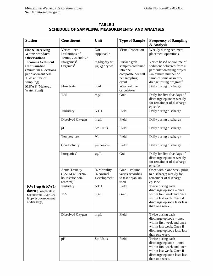
Montezuma Wetlands Restoration Project Order No. R2-2012-XXXX
Self Monitoring Program
TABLE 1 SCHEDULE OF SAMPLING, MEASUREMENTS, AND ANALYSIS
Station Constituent Unit Type of Sample Frequency of Sampling
& Analysis
Site & Receiving
Water Standard
Observations
Varies – see
Definitions of
Terms, C.4 and C.5
Not
Applicable
Visual Inspection Weekly during sediment
placement operations
Incoming Sediment
Confirmation
(minimum 4 locations
per placement cell
TBD at time of
sampling)
Inorganics1
Organics2
mg/kg dry wt.
µg/kg dry wt.
Surface grab
samples combined
into one
composite per cell
per sampling
event
Varies based on volume of
sediment delivered from a
particular dredging project
–minimum number of
samples same as in pre-
dredge testing program3
MUWP (Make-up
Water Pond)
Flow Rate mgd Weir volume
calculation
Daily during discharge
TSS mg/L Grab Daily for first five days of
discharge episode; weekly
for remainder of discharge
episode
Turbidity NTU Field Daily during discharge
Dissolved Oxygen mg/L Field Daily during discharge
pH Std Units Field Daily during discharge
Temperature °C Field Daily during discharge
Conductivity µmhos/cm Field Daily during discharge
Inorganics1
µg/L Grab Daily for first five days of
discharge episode; weekly
for remainder of discharge
episode
Acute Toxicity
(ASTM 48- or 96-
hour static non-
renewal)4
% Mortality
% Normal
Development
Grab – volume
varies according
to test organism
used
Once within one week prior
to discharge; weekly for
remainder of discharge
episode
RW1-up & RW1-
down (Two points in
Sacramento River 100
ft up- & down-current
of discharge)
Turbidity
TSS
NTU
mg/L
Field
Grab
Twice during each
discharge episode – once
within first week and once
within last week. Once if
discharge episode lasts less
than one week.
Dissolved Oxygen mg/L Field Twice during each
discharge episode – once
within first week and once
within last week. Once if
discharge episode lasts less
than one week.
pH Std Units Field Twice during each
discharge episode – once
within first week and once
within last week. Once if
discharge episode lasts less
than one week.

Montezuma Wetlands Restoration Project Order No. R2-2012-XXXX
Self Monitoring Program
Station Constituent Unit Type of Sample Frequency of Sampling
& Analysis
Temperature
°C
Field
Twice during each
discharge episode – once
within first week and once
within last week. Once if
discharge episode lasts less
than one week.
Conductivity µmhos/cm Field Twice during each
discharge episode – once
within first week and once
within last week. Once if
discharge episode lasts less
than one week.
Inorganics1
µg/L Grab Twice during each
discharge episode – once
within first week and once
within last week. Once if
discharge episode lasts less
than one week.
Phase I-IV Levee
Breaches (Stations
TBD)
Turbidity NTU Field D/W/M5
Dissolved Oxygen mg/L Field D/W/M
pH Std Units Field D/W/M
Temperature °C Field D/W/M
Conductivity µmhos/cm Field D/W/M
Inorganics1
µg/L Grab D/W/M
RW2-up & RW2-
down (Two points in
Montezuma Slough 100
ft up- & down-current
of levee breach)
Turbidity NTU Field D/W/M
Dissolved Oxygen mg/L Field D/W/M
pH Std Units Field D/W/M
Temperature °C Field D/W/M
Conductivity µmhos/cm Field D/W/M
Inorganics1
µg/L Grab D/W/M
MWP1 Well
Series (Phase I
Groundwater
Monitoring Wells)
Groundwater
Elevation
meters Field – measuring
tape
Bi-Annual (once during
wet season and once during
dry season)
pH
Std Units
Field
Bi-Annual (once during
wet season and once during
dry season)

Montezuma Wetlands Restoration Project Order No. R2-2012-XXXX
Self Monitoring Program
Station Constituent Unit Type of Sample Frequency of Sampling
& Analysis
Temperature °C Field Bi-Annual (once during
wet season and once during
dry season)
Conductivity µmhos/cm Field Bi-Annual (once during
wet season and once during
dry season)
Inorganics1 µg/L Grab Bi-Annual (once during
wet season and once during
dry season)
Pre-Breach
Biosentinel
Monitoring
(sediment placement
cells & make-up
water pond)
Methylmercury6
mg/kg wet
weight
Tissue7
Annual – during
breeding season for
selected biosentinel
species
Post-Breach
Habitat
Performance
TBD based on Post-Breach Habitat Performance Monitoring Plan, to be
submitted at least 60 days prior to breaching levees in Phase I pursuant to
Provision 7 of this Order. The Self-Monitoring Program shall be revised as
ordered by the Executive Officer upon acceptance of this plan. At a minimum, the
plan shall describe monitoring protocol for the following biological performance
measures:
Vegetation colonization (spatial extent, distribution, and
diversity)
Presence of special status wildlife species
Water quality conventional parameters (e.g., TSS, turbidity,
dissolved oxygen, pH, temperature, conductivity)
Methylmercury bioaccumulation in appropriate “biosentinel”
(resident or breeding) vertebrate species
Physical development of habitat features (e.g., channel
morphology, seasonal wetland hydrology).
The plan shall be designed to monitor the performance criteria specified in the
original MMRP, as well as any updates to the performance criteria in the MMRP
as recommended by the TRT and approved by the appropriate regulatory and
resource agencies. In addition, the plan shall include a decision tree linking
monitoring data to management actions that the Discharger can implement to
improve site conditions if performance criteria are not met.
1Arsenic, cadmium, chromium, copper, lead, mercury, nickel, selenium, silver, and zinc – reported as dissolved
except for mercury and selenium which should be analyzed and reported as total concentrations.
2PAHs (25 compounds reported by RMP), PCBs (40 congeners reported by RMP), organochlorine pesticides (total
Chlordanes, total DDT (sum of 6 isomers), Dieldrin)
3DMMO (2001) Guidelines for Implementing the Inland Testing Manual in the San Francisco Bay Region, Table 1.
Minimum Sediment Sampling Guidelines.
4ASTM E1192-97(2008) Standard Guide for Conducting Acute Toxicity Tests on Aqueous Ambient Samples and
Effluents with Fishes, Macroinvertebrates, and Amphibians, or equivalent method if acceptable to Executive
Officer.
5Once within 3 days prior to breach; during the first and fifth day following breach; weekly during the first month;
monthly thereafter until receiving water limits (Basin Plan water quality objectives for inorganics) met for three
consecutive months.
6If wildlife are identified foraging in uncovered foundation material placement cells during the breeding season,

Montezuma Wetlands Restoration Project Order No. R2-2012-XXXX
Self Monitoring Program
additional bioaccumulative contaminants may be added to the constituent list as appropriate based on sediment
concentrations reported during pre-dredge testing and placement cell confirmation sampling.
7Appropriate biosentinel species for each area will be determined in consultation with the TRT. Likely biosentinels
for the sediment placement cells include the eggs of non-special status shorebirds such as black-neck stilts and
American Avocets nesting near the cells. Small fish (whole body), if present, may be appropriate biosentinels for the
make-up water pond.


