Embed Size (px)
Citation preview

Specialist Report – Vegetation Resources
Montana Snowbowl Ski Area Master Development Plan EIS 1
Montana Snowbowl Ski Area Master Development Plan
Environmental Impact Statement
Specialist Report – Vegetation
Barry L. Dutton Soil Scientist
and Gregory Howard
Botanist
Revised February 2011 1.0 INTRODUCTION This document describes the existing vegetation resources within the proposed expansion area and identifies potential effects on this resource. Two alternatives are considered in this analysis, the Proposed Action (as described below and in the Master Development Plan [MSB 2004]) and No Action. Information contained in this report will be used in the Montana Snowbowl Environmental Impact Statement (EIS). 1.1 Background The Montana Snowbowl Ski and Summer Resort (MSB) is an alpine ski and summer resort located on both private and federal land approximately 12 miles north of Missoula, Montana. The federal land is administered by the Lolo National Forest (LNF). The existing ski area includes 1,138 acres of federal land administered by and under permit with the LNF and 80 acres of private land (owned by MSB) located at the base area (Appendix A, Figures 1-1 and 1-2). The base area is the location of the lodge and other administrative facilities at which skiers and other MSB users congregate and from which MSB is managed. The MSB currently operates a full winter (five to seven days per week) and limited summer schedule (Friday, Saturday, and Sunday). Existing facilities on LNF land include ski trails, lifts (both surface and chairlifts), small buildings, buried water and power lines, a snowmaking reservoir, hiking trails, mountain bike trails, and a folf (disc golf) course. Facilities on adjacent private land include ski trails, lifts, a rope tow, buildings, buried water and power lines, a snowmaking reservoir, hiking trails, a mountain bike trail, a potable water system, wastewater disposal systems, and parking areas. The proposed expansion area is on LNF land called TV Mountain. TV Mountain is adjacent to and immediately west of the existing permit area. The west side of TV Mountain is the location of the original Snow Park Ski Area, which was the predecessor to the current MSB. Snow Park operated on LNF land during the 1950s and closed in 1960. The ski area was then moved to the Butler Creek drainage and re-opened in 1961 due to the availability of higher elevation terrain, better snow conditions, and greater vertical drop. In addition to the original Snow Park Ski Area, the proposed expansion area includes areas of past timber harvest, existing roads, and utilities.

Specialist Report – Vegetation Resources
Montana Snowbowl Ski Area Master Development Plan EIS 2
The summit of TV Mountain is a designated communications site (under permit with the LNF) with numerous television, radio, and microwave facilities and would be surrounded by the proposed expansion area. The MSB has operated on the LNF under a Special Use Permit (SUP) since 1961. The MSB currently has a 40-year SUP (to expire in 2011). All of the existing SUP area on LNF land was assigned to Management Area (MA) 8 (ski areas) in the 1986 LNF Land and Resource Management Plan (United States Forest Service [USDA] 1986), referred to hereinafter as the Forest Plan. Approximately 706 acres of the proposed expansion area are currently assigned to MA 16 (timber production), and 399 acres are assigned to MA 25 (timber production within the constraint of achieving a visual quality standard of Partial Retention). 1.2 Proposed Action The MSB is proposing to expand its alpine ski and summer resort to LNF land on TV Mountain in the general location of where the original Snow Park Ski Area was permitted and operated. This expansion proposal is summarized in a revised Master Development Plan (MSB 2004) that was received by the LNF on December 6, 2004. The proposed expansion would increase the existing SUP area by 1,105 acres to 2,243 acres (Appendix A, Figure 1-1). New facilities on LNF land would include ski trails, lifts, buried lines (power, water, and wastewater), a snowmaking reservoir, hiking and mountain bike trails, two wastewater drainfields, a maintenance building, and a lodge. A new SUP would be required for the Proposed Action. This SUP would authorize additional development, construction, and operation of resort facilities on Forest Service land (in this case, Forest Service land administered by the LNF). The SUP would be granted under the authority of the National Forest Ski Area Permit Act of 1986 (16 United States Code [USC] 497b). This Act authorizes the Forest Service to issue term ski area permits “for the use and occupancy of suitable Nordic and alpine skiing operations and purposes” (Section 3(b)). The Act also states that a permit shall encompass such acreage as the Forest Service “determines sufficient and appropriate to accommodate the permittee’s needs for ski operations and appropriate ancillary facilities” (Section 3(b)). The Proposed Action would require an amendment to the Forest Plan. This amendment would change approximately 706 acres from MA 16 (timber production) and 399 acres from MA 25 (timber production) to MA 8 (ski areas). The total new SUP area would be 2,243 acres with this addition of 1,105 acres of LNF land in the proposed expansion. The current SUP allows MSB to operate on 1,138 acres of LNF land. The improvements described in the Proposed Action in this analysis (Table 1-1) would not all be constructed during a single year, but would be constructed over an approximately 11-year timeframe. 1.2.1 Scope of this Analysis The analysis of effects disclosed in this report includes any effects occurring from the entire project. Scope is defined in 40 Code of Federal Regulations (CFR) 1508.25 as the range of actions, alternatives, and effects, such as connected and cumulative actions and effects, considered in this report. In addition to the Proposed Action, which is described above,

Specialist Report – Vegetation Resources
Montana Snowbowl Ski Area Master Development Plan EIS 3
Connected Actions and past, present, and reasonably foreseeable actions are analyzed in this report. Connected Actions. Connected Actions for this project include (1) all activities on private land that would be completed in conjunction with the proposed expansion described above, and (2) some improvements in the existing SUP area that were approved under a 1996 decision by the LNF but have not yet been implemented (Table 1-1) (USDA 1996). Other Connected Actions include new facilities/improvements planned on adjacent private land: Expanded parking (30 more spaces, or 75 more SAOT, created by moving the existing
maintenance building) Continuous shuttle service on busy days Buried utility lines (power, water, and wastewater) Services building that would house bathrooms, ticket sales, and food sales Construction of a flow monitor on Butler Creek, maintenance of 30 gpm in Butler Creek at
the flow monitor during snowmaking, and monitoring and annual reporting to the LNF. For this analysis, the actual end result and effect of the Proposed Action cannot be accurately disclosed without including the additive improvements that would be implemented as Connected Actions (Table 1-1). Therefore, in this report the existing improvements are defined as all improvements that have already been constructed/completed in the existing SUP area. The components specific to the Proposed Action are discussed, but the cumulative totals related to the Proposed Action plus Connected Actions in the proposed new SUP area (and/or private land) are also identified. Past actions. Past actions include those known management actions (regardless of land ownership) that could potentially have similar effects as identified as resulting from the Proposed Action and No Action alternatives. Past actions include the Snow Park Ski Area located on LNF land on the west side of TV Mountain, the construction of the existing MSB resort on LNF land and private land, and an SUP area expansion and improvements approved in 1996 by the LNF (USDA 1996). Other past actions are the 2003 closure of the Marshall Mountain Ski Area, timber harvest, and related road construction. Present actions. Present actions include road maintenance and communications site operation on TV Mountain. Other present actions are vegetative and restoration treatments conducted within and adjacent to the LNF land by the Forest Service and private landowners. Reasonably foreseeable actions. Reasonably foreseeable actions include road maintenance and vegetative or restoration treatments (such as weed control) anticipated to occur inside of and adjacent to the proposed expansion area during the next 11 years. The Grant Creek Fuel Reduction Project was approved by the LNF in a 2007 Decision Notice (USDA 2007a). Although this project has already been approved, there are no implementation plans at this time or in the future (Paulsen 2010 personal communication). That project is therefore not included in the scope of this analysis. Table 1-1 summarizes all existing improvements at MSB completed as of winter 2009–2010, the Connected Actions, and the Proposed Action.

Specialist Report – Vegetation Resources
Montana Snowbowl Ski Area Master Development Plan EIS 4
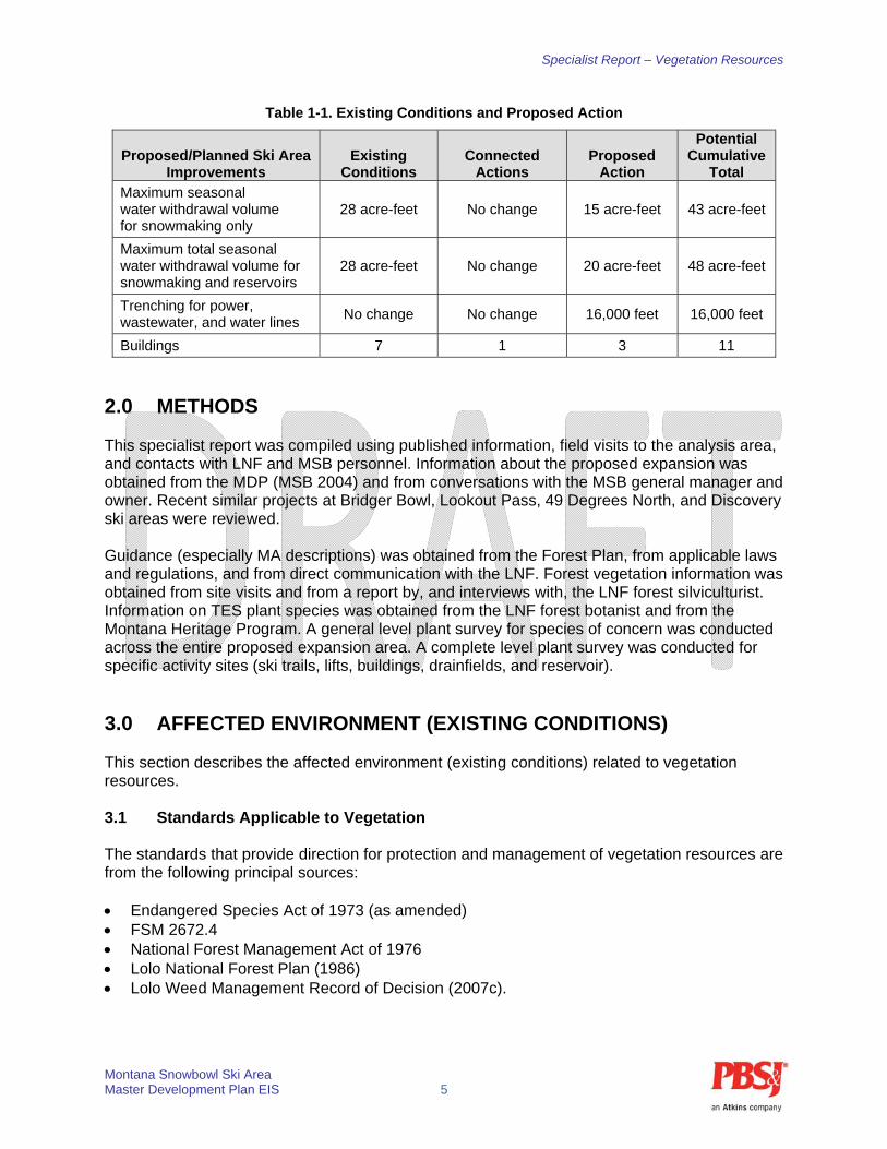
Table 1-1. Existing Conditions and Proposed Action
Proposed/Planned Ski Area Improvements
Existing Conditions
Connected Actions
Proposed Action
Potential Cumulative
Total Overall ski area capacity (SAOT)
1,408 skiers 0 skiers 937 skiers 2,345 skiers
SUP area size 1,138 acres No change 1,105 acres 2,243 acres
Ski trail capacity (SAOT) 1,500 skiers 193 skiers 1,373 skiers 3,066 skiers
Lift capacity (SAOT) 1,408 skiers 0 skiers 937 skiers 2,345 skiers
Base area capacity (SAOT) 1,629 skiers 771 skiers 0 skiers 2,400 skiers
Parking capacity (SAOT) (onsite + offsite lots)
2,775 skiers 75 skiers 0 skiers 2,850 skiers
Shuttle bus riders per day (from bottom of Grant Creek Road)
80 skiers 120 0 skiers 200 skiers
Ski trails: acreage 255 acres 20 acres 166 acres 441 acres
Ski trails: number 52 trails 8 trails 20 trails 80 trails
Ski trail capacity (SAOT): beginner/intermediate
1,050 skiers 190 skiers 1,250 skiers 2,490 skiers
Ski trail acreage: beginner/intermediate
105 acres 19 acres 125 acres 249 acres
Ski trail capacity (SAOT): advanced/expert
450 skiers 3 skiers 123 skiers 576 skiers
Ski trail acreage: advanced/expert
150 acres 1 acre 41 acres 192
Lifts: number 4 0 4 8
Tree removal for new ski trails and lifts only
No change 14 acres 153 acres 167 acres
Tree removal for new bike trails only
No change No change 5 acres 5 acres
Tree removal for new wastewater drainfields only
No change No change 10 acres 10 acres
Total tree removal No change 14 acres 168 acres 182 acres
Classified “old growth” tree removal
No change No addition 39 acres 39 acres
Grading for transition leveling and construction
No change No addition 39 acres 39 acres
Wastewater drainfields
Leave under main parking lot and base
area
No change Move to
TV Mountain (10 acres)
Move to TV Mountain
(10 acres)
Snowmaking reservoirs 2 0 1 3
Maximum water withdrawal rate
115 gpm 115 gpm 115 gpm 115 gpm
Specialist Report – Vegetation Resources
Montana Snowbowl Ski Area Master Development Plan EIS 5
Table 1-1. Existing Conditions and Proposed Action
Proposed/Planned Ski Area Improvements
Existing Conditions
Connected Actions
Proposed Action
Potential Cumulative
Total Maximum seasonal water withdrawal volume for snowmaking only
28 acre-feet No change 15 acre-feet 43 acre-feet
Maximum total seasonal water withdrawal volume for snowmaking and reservoirs
28 acre-feet No change 20 acre-feet 48 acre-feet
Trenching for power, wastewater, and water lines
No change No change 16,000 feet 16,000 feet
Buildings 7 1 3 11
2.0 METHODS This specialist report was compiled using published information, field visits to the analysis area, and contacts with LNF and MSB personnel. Information about the proposed expansion was obtained from the MDP (MSB 2004) and from conversations with the MSB general manager and owner. Recent similar projects at Bridger Bowl, Lookout Pass, 49 Degrees North, and Discovery ski areas were reviewed. Guidance (especially MA descriptions) was obtained from the Forest Plan, from applicable laws and regulations, and from direct communication with the LNF. Forest vegetation information was obtained from site visits and from a report by, and interviews with, the LNF forest silviculturist. Information on TES plant species was obtained from the LNF forest botanist and from the Montana Heritage Program. A general level plant survey for species of concern was conducted across the entire proposed expansion area. A complete level plant survey was conducted for specific activity sites (ski trails, lifts, buildings, drainfields, and reservoir).
3.0 AFFECTED ENVIRONMENT (EXISTING CONDITIONS) This section describes the affected environment (existing conditions) related to vegetation resources. 3.1 Standards Applicable to Vegetation The standards that provide direction for protection and management of vegetation resources are from the following principal sources: Endangered Species Act of 1973 (as amended) FSM 2672.4 National Forest Management Act of 1976 Lolo National Forest Plan (1986) Lolo Weed Management Record of Decision (2007c).

Specialist Report – Vegetation Resources
Montana Snowbowl Ski Area Master Development Plan EIS 6
Section 7 of the Endangered Species Act (ESA) directs federal agencies to ensure that actions authorized, funded, or carried out by them are not likely to jeopardize the continued existence of threatened or endangered species or result in destruction or adverse modification of their critical habitat. The FSM establishes policy for conducting biological evaluations for TES plant species. The National Forest Management Act provides for balanced consideration of all resources. It requires the Forest Service to plan for diversity of plant and animal communities. Under its regulations, the Forest Service is to maintain viable populations of existing and desired species and to maintain and improve habitat for management indicator species (MIS). The proposed MSB expansion would result in enlarging MA 8. Vegetation management guidance related to MA 8 includes: Tree removal will be limited to that required to eliminate safety hazards or permit
construction or expansion of facilities. Livestock grazing may be permitted if it does not conflict with the recreation use of the area. Trees with a high potential for physical failure or susceptibility to insects and disease will be
periodically evaluated. Hazardous conditions will be reduced by using acceptable methods such as single-tree removal or thinning.
Forest Plan Vegetation Regulatory Requirements. Forest-wide and MA goals and standards related to vegetation that apply to the Proposed Action are: Forest-wide Goal 2. Provide habitat for viable populations of all indigenous wildlife species
and increase populations of big game animals. Forest-wide Goal 4. Provide a pleasing and healthy environment, including clear air, clean
water, and diverse ecosystems. Forest-wide Standard 18. All management practices will be designed or modified as
necessary to maintain land productivity. Forest-wide Standard 56. Implementation of the principles of integrated pest management
will be accomplished through sound silvicultural prescriptions. Silvicultural practices will be designed to consider past, current, and potential impacts from insects and diseases.
Forest-wide Standard 57. Biological and vegetative management practices will be used to control insect and disease infestation.
Forest-wide Standard 58. In mountain pine beetle epidemic areas, all stands will be risk-rated and treatment priorities established on highest risk stands.
MA 8 Standard 1. Livestock grazing may be permitted if it does not conflict with the recreational use of the area.
MA 8 Standard 2. Tree removal will be limited to that required to eliminate safety hazards or permit construction or expansion of facilities. The MA is classified as unsuitable for timber production.
MA 8 Standard 6. Trees with a high potential for physical failure or susceptibility to insects and disease will be periodically evaluated. Hazardous conditions will be reduced by using acceptable methods such as single-tree removal or thinning.
MA 16 Goal 1. This goal provides for healthy stands of timber and optimizes timber growing potential.
MA 25 Goals 1 and 2. This goal provides for healthy stands of timber and optimizes timber growing potential within the constraint of achieving a visual quality standard of Partial Retention.

Specialist Report – Vegetation Resources
Montana Snowbowl Ski Area Master Development Plan EIS 7
An LNF Noxious Weed Management Record of Decision signed in 2007 identifies weed control goals and mitigation measures on the Forest. Additional direction on weed prevention is in the 1995 Region 1 FSM Supplement 2080, Noxious Weed Management (USDA 1995c). Vegetation goals and mitigation measures in this document applicable to the Proposed Action are in Appendix B. 3.2 Area of Analysis The analysis area for direct and indirect effects on vegetation resources is the proposed expansion area on TV Mountain. The area of analysis for cumulative effects on vegetation resources includes the existing SUP area in the Butler Creek and La Valle Creek drainages. 3.3 Vegetation Resource Affected Environment The vegetation affected environment includes forest types, old growth forest, wetlands and riparian areas, TES plants, and weeds. Forest Types Vegetation in the proposed expansion area is dominated by mature mixed conifer stands. Forest types include Douglas-fir, subalpine fir, and lodgepole pine. Douglas-fir types at TV Mountain are most common on south aspects and on east or west aspects at the lower elevations. Douglas-fir types occupy approximately 659 acres, or 61 percent, of the proposed expansion area. These forests include scattered ponderosa pine on south aspects and western larch and subalpine fir on the east and west aspects. A few grand fir are also present in these Douglas-fir types. Lodgepole pine types are present on the west aspect of TV Mountain and are most common at the higher elevations. Lodgepole pine types occupy approximately 278 acres, or 25 percent, of the proposed expansion area. These lodgepole pine types also include Douglas-fir, western larch, subalpine fir, and Engelmann spruce. A few grand fir are also present in the lodgepole pine type. Subalpine fir types are most common on the north and east aspects and at higher elevations. Subalpine fir types occupy approximately 151 acres, or 14 percent, of the proposed expansion area. These types also include Douglas-fir, Engelmann spruce, lodgepole pine, and western larch. Whitebark pine are scattered across the highest elevations, and grand fir are found across the lowest elevations in these subalpine fir types. Small areas of mountain hemlock are present on north aspects near the northern boundary of the proposed expansion area. The majority of these conifer forests are mature and are classified in the sawtimber size class. Habitat types in the proposed expansion area are dominated by subalpine fir types with smaller amounts of Douglas-fir types. Douglas-fir habitat types are confined to the south aspect of TV Mountain and to lower elevations on the southwest aspect. Douglas-fir habitat types occupy approximately 362 acres, or 33 percent, of the proposed expansion area. The most common Douglas-fir habitat type is Douglas-fir/ninebark with smaller areas of Douglas-fir blue huckleberry. Subalpine fir habitat types dominate the remaining aspects and higher elevations. Subalpine fir habitat types occupy approximately 726 acres, or 67 percent, of the proposed expansion area. The most common subalpine fir habitat is subalpine fir/beargrass with smaller amounts of subalpine fir/menziesia and subalpine fir/twinflower.
Specialist Report – Vegetation Resources
Montana Snowbowl Ski Area Master Development Plan EIS 8
Old Growth Forest Old growth forest stands covering approximately 318 acres are present in the proposed expansion area on TV Mountain. These areas include 201 acres of Douglas-fir old growth, 31 acres of lodgepole pine old growth, and 86 acres of subalpine fir old growth. Examination on the ground revealed that these areas only marginally meet old growth criteria (Green et al. 1992). These areas contain patches of trees old enough and in sufficient density to qualify as old growth. These patches range from less than 1 acre to several acres in size within larger stands of mature timber. This old growth falls within the Grant/O’Keefe Ecological Management Area. Currently, the total acreage of old growth forest in the Grant/O’Keefe Ecological Management Area is 1,452 acres out of a total Ecological Management Area acreage of 16,887 acres (8.6 percent). One site of old growth forest in the existing SUP area adjacent to the proposed expansion area includes mountain hemlock trees and is under consideration for nomination as a Botanical Special Interest Area. Wetlands and Riparian Areas Waters of the U.S. include wetlands, rivers, streams, and special aquatic sites. These areas are regulated by the U.S. Army Corps of Engineers under Section 404 of the Clean Water Act. Activities that affect waters of the U.S. require a detailed delineation report and permitting through the U.S. Army Corps of Engineers. Wetland specialists conducted a field inventory of the proposed expansion area during the summer of 2006 (Dutton and Howard 2006). No wetlands were identified in the proposed expansion area. La Valle Creek is located west of the proposed SUP boundary and is separated along its length by a well-vegetated buffer area. This vegetated buffer is 400 feet to 700 feet wide along most of the western project area boundary. A logging road on the hillslope above La Valle Creek (identified as FR 19080) serves as the boundary of the proposed SUP area (Appendix A, Figure 2-1). The distance between the road and the edge of the stream ranges from approximately 150 feet slope distance (at the switchback on the boundary of Sections 28 and 29) to over 2,000 feet in Section 5 (Appendix A, Figure 2-1). Threatened, Endangered, and Sensitive Plants No endangered plants are listed in Montana. Three plant species are listed as threatened in Montana, but these plants occupy wet habitats that do not occur on the proposed expansion area. Two of the three plants listed as threatened occur on the LNF: water howellia (Howellia aquatilis) and Spaulding’s campion/catchfly (Silene spaldingii). A search of the Montana Natural Heritage Program (MNHP) database revealed no past records of TES or plants of concern in the proposed expansion area. One sensitive species was recorded within a 5-mile radius of the proposed expansion area: podgrass (Scheuchzeria palustris). The recorded podgrass was observed to the east of the proposed expansion area within the Rattlesnake Wilderness Area. Potential habitat for this sensitive species ranges from wet organic soils to wet meadow, seep areas. No areas of this habitat are present in the proposed expansion area. Table 3-1 lists the TES species known or expected to occur on the LNF. Species in Table 3-1, (marked with “Y”) were identified as the most likely to occur at the proposed expansion area (Lavelle 2006). The most likely of these species to occur is clustered lady’s slipper (Cypripedium fasciculatum), which is found in the Douglas-fir/ninebark habitat type. This habitat type occurs in

Specialist Report – Vegetation Resources
Montana Snowbowl Ski Area Master Development Plan EIS 9
the proposed expansion area on the south aspect of TV Mountain. This area was surveyed by LNF personnel in 2001, and no clustered lady’s slipper or other TES plants were found. The remaining seven species with a “Y” designation in Table 3-1 have habitats that range from open forest to grasslands and meadows. No TES plants are currently known to occur in the proposed expansion area. Searches conducted by the LNF for past projects in the proposed expansion area detected no TES plant species (Lavelle 2006). A survey conducted by PBS&J during the 2006 field season also detected no TES plant species. This survey included a general level plant survey across the entire proposed expansion area and a complete level plant survey for specific activity sites where significant ground disturbance would occur (ski trails, lifts, buildings, drainfields, and reservoir). The formal survey was conducted on two dates to span the period of potential flowering for clustered lady’s slipper (Dutton and Howard 2006). PBS&J plant specialists also made vegetation observations during other field trips to the proposed expansion area and identified no TES plant species (Dutton and Howard 2006). TES plant surveys were conducted in the area in 2005 and 2006 as part of the Grant Creek Fuel Reduction Project analysis (USDA 2007a). No TES plants were found during these surveys.
Table 3-1. Lolo National Forest Threatened, Endangered, and Sensitive Plants (October 2004)
Scientific Name Common Name Habitat2
Potentially Present Proposed
Expansion Area1
Adoxa moschatellina Musk-root Rock slides/moist with cold air drainage
N
Allium acuminatum Tapertip onion Dry, open forests and grasslands Y
Amerorchis rotundifolia
Round-leaved orchis
Spruce forest/seeps and streams, limestone soils
N
Arabis fecunda Sapphire rockcress
Steep slopes/sparse vegetation/ warm aspects
N
Athysanus pusillus Sandweed Moist/steep slopes and cliffs N
Bidens beckii Beck water-marigold
Lakes/rivers/sloughs N
Botrychium paradoxum
Peculiar moonwort
Meadows within spruce and lodgepole forest
N
Brasenia schreberi Watershield Lakes/sloughs/slow moving rivers N
Carex chordorrhiza Creeping sedge Wet organic soils/fens N
Carex rostrata Beaked sedge Wet organic soils/fens/floating peat bogs
N
Clarkia rhomboidea Common clarkia Dry, open forest slopes with gravelly soils
Y
Claytonia arenicola Sand springbeauty
Mossy, forested, north-facing talus slopes
N
Cypripedum fasciculatum
Clustered lady’s slipper
Douglas-fir/ninebark and grand fir/ninebark types
Y

Specialist Report – Vegetation Resources
Montana Snowbowl Ski Area Master Development Plan EIS 10
Table 3-1. Lolo National Forest Threatened, Endangered, and Sensitive Plants (October 2004)
Scientific Name Common Name Habitat2
Potentially Present Proposed
Expansion Area1
Cypripedum parviflorum
Small yellow lady’s slipper
Fens/mossy woods/seepage areas N
Cypripedum passerinum
Sparrow’s egg lady’s slipper
Seepy, coniferous forests/calcareous soils
N
Drosera anglica English sundew Wet organic soils/fens N
Dryopteris cristata Buckler fern Wet organic soils/forest margins of fens
N
Epipactis gigantean Giant helleborine
Streambanks/lake margins/fens N
Eupatorium occidentalis
Western boneset
Rocky outcrops and slopes N
Gentianopsis simplex Hiker’s gentian Fens/meadows/seeps N
Grimmia brittoniae (moss) Moist forest dominated by Douglas-fir
N
Grindelia howellii Howell’s gumweed
Ponds/marshes N
Heterocodon rariflorum
Western pearl-flower
Moist grassland slopes/mossy ledges/riparian
Y
Howellia aquatilis Water howellia (threatened)
Wetlands/glacial pothole ponds N
Idahoa scapigera Scalepod Moist, open soil on rock ledges N
Kalmia polifolia Pale laurel Peatlands/spruce forest margin/ lake margins
N
Meesia triquetra (moss) Wetlands N
Mertensia bella Oregon bluebells
Wet, seepy, open or partially shaded slopes
N
Orogenia fusiformis Tapered-root onion
Open slopes/ridges/meadows Y
Phlox kelseyi v. missoulensis
Missoula phlox Limestone-derived slopes in the foothills
N
Potamogeton obtusifolius
Blunt-leaved pondweed
Lakes/ponds/sloughs N
Scheuchzeria palustris
Pod grass Wet organic soils/fens N
Scirpus subterminalis Water bulrush Ponds/lakes/sloughs N
Silene spaldingii
Spalding’s campion/ catchfly (threatened)
Grasslands N
Trifolium eriocephalum
Woolly-head clover
Mixed conifer forest Y

Specialist Report – Vegetation Resources
Montana Snowbowl Ski Area Master Development Plan EIS 11
Table 3-1. Lolo National Forest Threatened, Endangered, and Sensitive Plants (October 2004)
Scientific Name Common Name Habitat2
Potentially Present Proposed
Expansion Area1
Trifolium gymnocarpon
Hollyleaf clover Open woods and slopes/sagebrush to ponderosa
Y
Waldsteinia idahoensis
Idaho barren strawberry
Open ponderosa pine forest Y
1 Species identified by Darlene Lavelle (LNF Botanist) to be associated with potential habitat located in the proposed expansion area.
2 Habitat descriptions referenced from the MNHP website, Species of Concern database (MNHP 2006). Old Growth Mountain Hemlock Site One site of old growth forest in the existing SUP area includes mountain hemlock (Tsuga mertensiana) trees. This site is one of the easternmost occurrences of mountain hemlock in the Rocky Mountains and is being considered for nomination as a Botanical Special Interest Area. It is located adjacent to the proposed expansion boundary approximately 1,000 feet north of the existing snowmaking reservoir at Spartan Saddle (Appendix A, Figure 2-1). Weeds Weeds are exotic (non-native) plants that often invade disturbed sites and replace native species. Weeds use a variety of adaptive strategies to compete with other plants and are often more efficient at utilizing moisture and nutrients. Some weeds are considered special threats and are designated as noxious by the State of Montana. Noxious weeds must be controlled according to the Montana County Noxious Weed Control Act (MCA 7-2101 through 2153). Weeds may be controlled by a variety of cultural, mechanical, biological, and herbicide methods. The most effective weed control is prevention of weed establishment by the minimization of soil disturbance and maintenance of healthy and competitive desirable vegetation that is well-adapted to the site. Weeds are present in the existing SUP area, the proposed expansion area, and along the access road (Snowbowl Road). Table 3-2 lists weeds of concern on the LNF and those that have been identified on the proposed expansion area. Weed names in bold text are listed as noxious in Montana.

Specialist Report – Vegetation Resources
Montana Snowbowl Ski Area Master Development Plan EIS 12
Table 3-2. Noxious and Other Weeds of Concern on the Lolo National Forest and Proposed Expansion Area*
Status/Goal Scientific Name Common Name Present
LNF
Present Proposed Expansion
Area
Potential Invaders
Currently absent; goal is to prevent and eradicate promptly if
found.
Bryonia alba White bryony Y N
Centaurea repens Russian knapweed Y N
Centaurea solstitalis Yellow starthistle Y N
Chondrilla juncea Rush skeletonweed Y N
Crupina vulgaris Common crupina Y N
Echium vulgare Blueweed Y N
Iris pseudacorus Yellowflag iris Y N
Isatis tinctoria Dyers woad Y N
Lythrum spp. Purple loostrife Y N
Tamarix spp. Salt cedar Y N
New Invaders
Goal is to eradicate small new infestations
and reduce larger infestations.
Cardaria draba White top Y N
Centaurea diffusa Diffuse knapweed Y N
Hieracium aurantiacum
Orange hawkweed Y Y
Hieracium piloselloides
Meadow hawkweed complex
Y N
Hieracium pratense Yellow hawkweed Y N
Lepidium latifolium Perennial pepperweed
Y N
Linaria vulgaris Common toadflax Y N
Ranunculus acris Tall buttercup Y N
Senecio jacobaea Tansy ragwort Y N

Specialist Report – Vegetation Resources
Montana Snowbowl Ski Area Master Development Plan EIS 13
Table 3-2. Noxious and Other Weeds of Concern on the Lolo National Forest and Proposed Expansion Area*
Status/Goal Scientific Name Common Name Present
LNF
Present Proposed Expansion
Area
Widespread
Goal is to contain inside infested area
and reduce plant populations.
Bromus japonicus Japanese brome Y N
Bromus tectorum Cheatgrass Y Y
Cardus nutans Musk thistle Y Y
Centaurea maculosa Spotted knapweed Y Y
Chrysanthemum leucanthemem
Oxeye daisy Y Y
Cirsium arvense Canada thistle Y Y
Cynoglossum officinale
Houndstongue Y Y
Euphorbia esula Leafy spurge Y Y
Hypericum perforatum
St. Johnswort Y Y
Linaria dalmatica Dalmatian toadflax Y N
Potentilla recta Sulfur cinquefoil Y N
Sisymbrium altissimum
Tumble mustard Y N
Tanacetum vulgare Common tansy Y Y
Verbascum spp. Mullein Y Y
* Species in bold text are listed as noxious weeds on the Montana Noxious Weed List, effective September 2010 (MDA 2010) The most common weed in the proposed expansion area is spotted knapweed, which occurs in a spotty distribution along most roads and at the TV Mountain communication site. Knapweed also occurs in a scattered distribution on past timber harvest sites. Other weeds observed in the proposed expansion area and listed above occur in the same locations but are generally limited to very small patches or individual plants. These same weeds occur across the existing SUP area. Spotted knapweed is common at the main parking lot, base area, lower ski trails, Snowbowl Road, maintenance roads, and bike trails. The remaining weeds listed occur in a more spotty distribution on disturbed sites across the existing permit area. Weeds generally are most common near the base area and roads. They generally decrease in abundance away from roads, at higher elevations, and on north aspects. Past MSB weed inventories have identified approximately 137 acres of infested area (USDA 2007c). All of the weeds present at MSB also occur in the surrounding landscape, especially along Snowbowl Road. A number of other non-native invasive plants, including wide-leaf plantain and common dandelion, occur in the proposed expansion area. Exotic grasses such as cheatgrass brome, quackgrass, orchard-grass, Kentucky bluegrass, and timothy are also present. These grasses occupy space that could be used by native plants.

Specialist Report – Vegetation Resources
Montana Snowbowl Ski Area Master Development Plan EIS 14
The MSB is responsible for direct control of noxious weeds in the SUP area. Biological controls may be used to supplement, but may not replace, direct control activities. By March 1 of each year, MSB submits a proposed weed treatment plan for the upcoming season. The plan must include a list of applicators the permittee intends to use and copies of their Montana Department of Agriculture applicator licenses. All herbicide treatments are conducted by a state-certified applicator. By September 30 of each year, MSB reports weed control accomplished (locations, acres, species, and map) and daily diaries (on LNF-provided forms). The LNF provides MSB a list of noxious weeds to be controlled in the permit area. MSB weed control activities are conducted, in order of priority, as follows: 1. Roads, trails, parking areas, and areas of concentrated public use (such as around warming
huts). Roads and ski trails used for motorized access are maintained in a weed-free condition.
2. Recently disturbed areas (such as excavations or grading sites). 3. Ski trails. 4. General forest areas within the SUP boundary. Weed infestations are mapped and monitored annually to ensure the weed management program is being implemented effectively. Past weed treatments in the proposed expansion area have been dominated by herbicide applications along roadways. Currently, the Point Six Road joint users contribute to road maintenance and weed control on the road segments used by each user as required by their SUP. The road was treated in 2006 and is checked and retreated as needed.
4.0 ENVIRONMENTAL CONSEQUENCES (DIRECT, INDIRECT AND CUMULATIVE EFFECTS) 4.1 Alternative A - The No Action Alternative The No Action alternative would maintain the existing condition at MSB as discussed in Section 3.0 and Table 1-1. Under this alternative, no tree removal or vegetation disturbances would occur for ski trail and lift construction or other facilities. The 1,105-acre expansion area would not be reclassified from MAs that emphasize timber production to an MA that emphasizes ski area recreation (MA 8). The 182 acres of proposed and planned tree removal, including 39 acres of old growth forest, would not occur. The proposed removal of 14 acres of trees for planned trails (Connected Actions) may not be implemented. There would be no potential to affect TES plant species or their habitat because no tree removal or other proposed disturbances would occur. No increase in potential weed spread above current levels due to tree removal and other soil disturbances proposed for the proposed project would occur.

Specialist Report – Vegetation Resources
Montana Snowbowl Ski Area Master Development Plan EIS 15
4.2 Alternative B - The Proposed Action Forest Types Other direct and indirect effects of the proposed project on vegetation would include tree removal for ski trails, lifts, wastewater drainfields, buildings, bike trails, and a snowmaking reservoir. The total acreage of tree removal for all project components (plus Connected Actions) would be 182 acres. Most tree removal would occur in Douglas-fir (110 acres) and lodgepole pine (48 acres) types on the west side of TV Mountain. A small area of tree removal would occur in subalpine fir types (24 acres) on north and east aspects at higher elevations. Habitat types affected by this tree removal would mainly be subalpine fir types (138 acres), with small areas of Douglas-fir types (44 acres) at the lower elevations. For the Proposed Action (plus Connected Actions), most of the 182-acre tree removal area would have trees harvested, but the understory vegetation would remain intact. Sites where vegetation would be completely removed would include drainfields (10 acres), bike trails (5 acres), a new reservoir (1 acre), and graded areas on ski trails (23 acres), for a total of 39 acres. These sites where vegetation would be completely removed would nearly all be in the Douglas-fir and lodgepole pine timber types on the west side of TV Mountain. Drainfields, graded areas, and most of the bike trail (except trail surface) would be revegetated with native species after construction. Cumulative effects would include the vegetation removal that has already occurred as part of the development of the existing SUP area. It is unknown what acreage of forest types has been removed on the existing SUP area, but the proposed expansion would cumulatively add to tree removal in the Butler Creek and La Valle Creek watersheds. Old Growth Forest Approximately 39 acres of old growth forest would have trees removed for ski trails, lifts, and other project components. Currently, the total acreage of old growth forest in the Grant/O’Keefe Ecological Management Area is 1,452 acres out of a total area of 16,887 acres (8.6 percent). Removing 39 acres of old growth for this project would reduce the total in Grant/O’Keefe to 8.4 percent, which would still meet the goal of 8 percent or more in each area. An old growth mountain hemlock stand in the existing SUP area adjacent to the proposed expansion area would not be affected. Cumulative effects on vegetation resources were identified by considering the Proposed Action in relation to the existing SUP area. It is unknown whether old growth forest was removed as part of the development of the existing SUP area. Wetlands and Riparian Areas No wetland or riparian areas would be affected by this project because none occur in the proposed expansion area. Because no wetland or riparian areas would be affected by this project, there are no cumulative effects on these resources.

Specialist Report – Vegetation Resources
Montana Snowbowl Ski Area Master Development Plan EIS 16
Threatened, Endangered, and Sensitive Plants No TES plant species have been identified in the proposed expansion area. These surveys have targeted all sites to be disturbed for ski trail and other construction activities. Approximately 10 acres of potential clustered lady’s slipper habitat would be disturbed for ski trail construction on the south side of TV Mountain. This construction would remove all trees along an approximately 100-foot-wide path. Tree removal is reported to negatively impact clustered lady’s slipper (Lichthardt 2003). Cumulative effects on TES plant species were identified by considering the expansion project in relation to the existing SUP area. It is unknown whether clustered lady’s slipper was removed as part of the development of the existing SUP area. Weeds Under the alternatives, weed management would continue as described in the MSB Operating Plan and using the weed mitigation measures in Appendix B. The Missoula Ranger District Integrated Weed Management Program uses education; prevention; biological, mechanical, and cultural methods; and herbicides as tools to contain, control, and eradicate invasive noxious weeds on LNF lands. The potential for weed spread would increase under the Proposed Action due to tree removal, importing mechanized equipment, grading, and soil disturbances related to ski trail, ski lift, and other construction activities. Weed spread potential would be greatest on the 39 acres to be graded for ski trail construction, bike trails, drainfields, and a new reservoir. All soil-disturbing activities would include weed treatments to control or contain existing weed infestations and prevent establishment of new weed species. While these activities would be aggressive, they would not be 100 percent effective. The result would be some new weed establishment in and around soil disturbance and vegetation removal areas. The cumulative effects of the Proposed Action on weeds were identified by considering the expansion project in relation to the existing SUP area. The potential for weeds to invade or spread would increase due to soil-disturbing and vegetation removing activities related to the proposed ski area expansion. The entire expanded SUP area would, however, implement weed control according to existing standards.
5.0 ALTERNATIVES No alternatives were identified based on vegetation resources.

Specialist Report – Vegetation Resources
Montana Snowbowl Ski Area Master Development Plan EIS 17
6.0 MITIGATION MEASURES AND MONITORING Mitigation 1. Standard timber sale contract clauses would be used. The clauses would address
standard soil operating practices, watershed resources, and residual timber protection by requiring:
a. Directional felling.
b. Pre-approved skid trails and landings.
c. Logs yarded with leading edge free of the ground.
d. Skyline corridor spacing.
e. That summer ground-based harvest activities be conducted in the dry season, between June 15 and September 15. Ground-based winter activities would follow the directions for activities during snow cover and/or frozen ground conditions. Operations outside of the specified conditions may occur only on a case-by-case basis after consultation with a Forest Service hydrologist or soil scientist.
f. That tractor and/or skidder yarding be limited to slopes less than 35 percent except for short pitches up to 40 percent.
g. The rehabilitation of landings as soon as possible after the completion of harvest operation or slash disposal/burning (whichever occurs last). Landings would be ditched or sloped to permit water drainage or spread, scarified, seeded with an LNF-approved native seed mix, and covered with woody debris or mulch.
h. That skid trails be water barred and green slash scattered across their surfaces and, where appropriate, ripped and seeded.
2. At sites with ground disturbance, revegetation efforts would include stockpiling topsoil with incorporated plant materials and re-spreading as quickly as possible to promote re-sprouting. All graded sites would be seeded with a mixture of native and desirable non-native plant species, primarily grasses. Cut and fill slopes would be planted with trees where practical and where it is compatible with use. Shredded bark/tree or other suitable mulch would be used where needed. These sites would be monitored for weed invasion and revegetation success. Weeds found in monitoring would be treated with herbicides.
3. Timber sale provisions would be used. The provisions would protect ponderosa pine and western larch regeneration (or natural regeneration) during harvests, residual trees and snags, and other resource amenities.
4. Old growth trees would be retained on sites scheduled for ski trail construction when possible (when skiing and grooming needs allow).
5. Borate would be applied to ponderosa pine stumps 12 inches or larger within 48 hours of felling trees to prevent the spread of annosum spp. root disease.
6. Mitigation measures 1 through 48 listed in Chapter 2 of the LNF Integrated Weed Management Final EIS (USDA 2007a) would be followed to minimize unwanted potential effects of weed management practices (Appendix B).
7. Wood waste would be used as much as possible for firewood in services buildings.

Specialist Report – Vegetation Resources
Montana Snowbowl Ski Area Master Development Plan EIS 18
Monitoring All regeneration and revegetation activities would be monitored for success in achieving adequate coverage to prevent soil erosion. Adequate tree cover would be established where desired. Special focus would be placed on project components closest to streams and on sites at high risk to weed invasion.
7.0 COMMENT REVIEW Comments were received during scoping that identified concerns with maintaining vegetative buffers along Butler Creek and La Valle Creek. These comments are addressed in this Specialist Report.
8.0 FOREST PLAN CONSISTENCY AND MANAGEMENT AREA CHANGE
Both Alternative A and Alternative B would be in compliance with the general vegetation goals and objectives of the Forest Plan. These standards are summarized in Section 3.4.1. The Proposed Action would meet Forest Plan requirements because no TES plant species have been identified at the site or in the immediate area. The proposed project may impact individuals and habitat (clustered lady’s slipper), but would not likely contribute to a trend toward federal listing or a loss of viability to clustered lady’s slipper and its known populations. For all other sensitive plants, the Proposed Action would not be expected to have direct, indirect, or cumulative effects, and it would be consistent with the Forest Plan. The Proposed Action would allow the expansion of MSB onto TV Mountain and would reclassify the area from MA 16 and MA 25 to MA 8. This would remove the 1,105-acre expansion area from the timber base and place it in a ski area classification. Although the new MA designation would no longer emphasize timber growth, future harvest of timber would likely occur in relation to future forest health and MSB goals.

Specialist Report – Vegetation Resources
Montana Snowbowl Ski Area Master Development Plan EIS 19
9.0 SOURCES OF INFORMATION Dutton, B. and G. Howard. 2006. Threatened, endangered and sensitive plant inventory notes
at TV Mountain ski area expansion site. Filed in project file.
Green, P., J. Joy, D. Sirucek, W. Hahn, A. Zack and B. Naumann. 1992. Old-growth forest types of the northern region. In: Our Approach to Sustaining Ecological Systems. R-1 SES, April 1992. USDA Forest Service Northern Region. Missoula, MT.
Lavelle, Darlene. 2006. Lolo National Forest Sensitive Plant Field Guide. USFS, Missoula, MT. 120 pp.
Lichthardt, J. 2003. Conservation Strategy for Clustered Lady’s Slipper Orchid (Cypripedium fasciculatum) in U.S. Forest Service Region I. Idaho Department of Fish and Game, Boise, 25 pp., plus appendices.
Montana Department of Agriculture (MDA). 2010. Montana Noxious Weed List. Effective September 2010. Website: http://agr.mt.gov/weedpest/pdf/weedlist2010.pdf.
Montana Natural Heritage Program (MNHP). 2006. Plant and animal species of special concern. Letter report from Kathy Lloyd (MNHP) to Stephanie Lauer (PBS&J).
Montana Snowbowl (MSB). 2004. Montana Snowbowl Master Development Plan. Prepared for Montana Snowbowl by Alpentech and Robert Brandenberger. December 2004.
Paulsen, Tami. 2010. Lolo National Forest. Personal communication with Stephanie Lauer of PBS&J.
United States Department of Agriculture, Forest Service (USDA). 1986. Lolo National Forest (LNF). Forest Plan. Online at: http://www.fs.fed.us/r1/wmpz/documents/existing-forest-plans.shtml.
United States Department of Agriculture, Forest Service (USDA). 1995c. Forest Service Manual Washington, Series 2000 - National Forest Resource Management. Document No. 2080. Amendment No. 2000-95-5, Effective November 29, 1995.
United States Department of Agriculture, Forest Service (USDA). 1996. Lolo National Forest (LNF). Decision Notice and Finding of No Significant Impact for Snowbowl Master Development Plan Environmental Assessment. Prepared by Missoula Ranger District, April 1996.
United States Department of Agriculture, Forest Service (USDA). 2007a. Lolo National Forest (LNF). Environmental Assessment: Grant Creek Fuels Reduction Project. 159 pp.
United States Department of Agriculture, Forest Service (USDA). 2007c. Record of Decision: Integrated Weed Management on the Lolo National Forest. December 2007.

Specialist Report – Vegetation Resources
Montana Snowbowl Ski Area Master Development Plan EIS
Appendix A
Figures

Specialist Report – Vegetation Resources
Montana Snowbowl Ski Area Master Development Plan EIS A-1
Figure 1-1. Montana Snowbowl Vicinity Map

Specialist Report – Vegetation Resources
Montana Snowbowl Ski Area Master Development Plan EIS A-2
Figure 1-2. Base Area Map Montana Snowbowl

Specialist Report – Vegetation Resources
Montana Snowbowl Ski Area Master Development Plan EIS A-3
Figure 2-1.Existing and Proposed Expansion Areas

Specialist Report – Vegetation Resources
Montana Snowbowl Ski Area Master Development Plan EIS
Appendix B
Weed Mitigation for MSB Expansion to TV Mountain

Specialist Report – Vegetation Resources
Montana Snowbowl Ski Area Master Development Plan EIS B-1
Weed Mitigation Applicable to MSB from the LNF December 2007 Weed ROD
General Mitigation Measures
1) New invaders, as identified by local and state agencies, will be given high priority for treatment.
2) All weed treatment activities will comply with state and local laws and agency guidelines.
3) Region 1 weed prevention practices will be applied to forest management activities. New weed prevention Best Management Practices will be implemented as they are developed.
4) Revegetation on disturbed or treated sites should include native plant species as recommended by the USFS-R1 native species policy (USDA-FS 1994). This policy emphasizes the use of locally adapted native plant seed, whenever possible.
5) Biological agents will not be released until they are screened for host specificity and approved by the USDA Animal Plant Health Inspection Service.
Herbicide mitigation measures - include the above measures, plus
6) Signs will be posted at access points to heavily used recreation areas and heavily used areas of the forest where herbicides are applied to let the general public, chemically sensitive people and others who may wish to avoid herbicides know the estimated date(s) of treatment, the herbicide to be used and a name and phone number of who to call for more information.
7) All application of herbicides will be performed by, or supervised by, a state licensed applicator following all current legal application procedures administered by the Montana Department of Agriculture.
8) All herbicides will be handled following the EPA label guidelines and other state and federal laws for storage, application, and disposal methods.
9) Mixing will take place at least 150’ from open water unless spill containment devices are readily available and an anti back siphoning device is used when drafting water.
10) Applicators will review stream and wetland areas to assure that herbicides will not be applied to open water.
11) Herbicides will be used to waters edge only when absolutely needed and provided the product label allows such use.
12) Herbicide applications near live water or in areas with shallow water tables will follow label directions.
13) Herbicide applicators will not initiate spraying when heavy rains are forecast that could cause offsite herbicide transport into sensitive resources such as streams.
14) Herbicides applicators will be familiar with and carry a Herbicide Emergency Spill Plan (Appendix C in LNF December 2007 Weed EIS) to reduce the risk and potential severity of an accidental spill. Herbicides applicators will also carry spill containment equipment.
15) All herbicide applications in riparian areas will be documented on the Mitigation Measure Certification form included as Appendix E in LNF December 2007 Weed EIS to document protection of surface waters.
16) Herbicides will not be applied if snow or ice covers the target vegetation.
17) Spray equipment will be calibrated each season and recalibrated as needed during the spray season.
18) Low boom pressure (less than 40 pounds per square inch) will be used to reduce drift.
19) Drift reduction products will be used as needed near sensitive resources.
20) Ground-based herbicide application will occur only when wind speed is 10 mph or less.

Specialist Report – Vegetation Resources
Montana Snowbowl Ski Area Master Development Plan EIS B-2
21) If commercial applicators are used for the application of restricted use pesticides, copies of their Montana commercial restricted use pesticide license will be checked to ensure it is current and a copy of that license shall be provided to the Forest Service.
Aerial application mitigation measures - include the above measures, plus
22) Temporary road and area closures will be used as needed to ensure public safety during aerial spray operations.
23) A “no-fly” zone will be designated to avoid disturbance to active bald eagle and peregrine falcon eyries.
24) Aerial spray project areas will be marked or delineated so treatment boundaries are clear to the application pilot.
25) Buffer zones and treatment areas will be reviewed with the application pilot prior to application.
26) To mitigate drift, there will be a 300-foot buffer next to sensitive resources unless drift card monitoring or other information indicates a smaller buffer is effective. Even if drift card monitoring indicates smaller buffer will be effective, the buffer will never be less than 150 feet wide.
27) Application will occur only when wind speed is 6 mph or less.
28) Aircraft smokers, smoke bombs or on-site wind monitoring will be used as needed to determine wind direction near sensitive resources.
29) Spray detection cards will be used as needed inside representative or critical buffer zones near sensitive resources.
30) Do not conduct aerial herbicide applications during temperature inversions.
31) Maintain close communications between the helicopter pilot and the ground field observers to monitor drift, deposition and wind speeds during aerial applications of herbicides.
32) GPS systems should be used in spray helicopters in association with flagging or field marking of treatment areas to ensure accuracy of aerial treatments (i.e. to better assure that only areas marked for treatment are treated).
33) Drift reduction agents and nozzles that create large droplets to reduce drift to non target areas should be used during aerial herbicide applications
Weed Prevention Measures Applicable to MSB from FSM 2081.2
In all NF System lands operations: Inspect, remove, and properly dispose of weed seed and plant parts found on personnel, clothing and equipment.
Conduct, provide and document weed identification and prevention briefings for ski area staff at least annually.
1. Road Use and Management.
(1) Incorporate weed prevention into road layout, design, and alternative evaluation.
(2) Remove the seed source that could be picked up by passing vehicles and limit seed transport in new and reconstruction areas.
(a) Remove all mud, dirt, and plant parts from all off road equipment before moving into project area. Cleaning must occur off National Forest lands.

Specialist Report – Vegetation Resources
Montana Snowbowl Ski Area Master Development Plan EIS B-3
(3) Re-establish vegetation on bare ground due to construction and reconstruction activity to minimize weed spread.
(a) Revegetate all disturbed soil, except the travel way on surfaced roads, in a manner that optimizes plant establishment for that specific site, unless ongoing disturbance at the site will prevent weed establishment. Use native material where appropriate and available. Use a seed mix that includes fast, early season species to provide quick, dense revegetation. To avoid weed contaminated seed, each lot must be tested by a certified seed laboratory against the all State noxious weed lists and documentation of the seed inspection test provided.
(b) Use local seeding guidelines for detailed procedures and appropriate mixes (LNF Revegetation Guidelines and Mixes). Use native material where appropriate and available. Revegetation may include planting, seeding, fertilization, and weed-free mulching as indicated by local prescriptions.
(c) Monitor and evaluate success of revegetation in relation to project plan. Repeat as indicated by local prescriptions.
(4) Minimize the movement of existing and new weed species caused by moving infested gravel and fill material. The borrow pit will not be used if LNF listed weeds are found on site until it has been treated and certified weed free.
(5) Minimize sources of weed seed in areas not yet revegetated. If straw is used for road stabilization and erosion control, it must be certified weed-free or weed-seed free.
(6) Minimize roadside sources of weed seed that could be transported to other areas during maintenance.
(a) Look for priority weed species during road maintenance and report back to District Weed Specialist.
(b) Do not blade roads or pull ditches where new invaders are found.
(c) Maintain desirable roadside vegetation. If desirable vegetation is removed during blading or other ground disturbing activities, area must be revegetated according to sections above.
(7) Retain shade to suppress weeds. Consider minimizing the removal of trees and other roadside vegetation during construction, reconstruction, and maintenance, particularly on southerly aspects.
Specialist Report – Vegetation Resources
Montana Snowbowl Ski Area Master Development Plan EIS B-4
2. Timber Removal and Management.
(1) Ensure that weed prevention is considered in all pre-harvest timber projects.
(b) Remove all mud, dirt, and plant parts from all off road equipment before moving into project area. Cleaning must occur off National Forest lands.
(2) Minimize the creation of sites suitable for weed establishment. Revegetate bare soil as described in the Roads section above.
(a) Treat weeds on landings, skid trails and helibases that are weed infested before logging activities, where practical.
3. Soil and Water.
(1) It is required that integrated weed prevention and management be used in all soil, watershed, and stream restoration projects.
(a) Revegetate bare soil resulting from excavation activity according to the Roads section above.
(c) Remove all mud, dirt, and plant parts from all off road equipment before moving into project area. Cleaning must occur off National Forest lands.
(c) Straw used for road stabilization and erosion control will be certified weed-free or weed-seed-free.
4. Lands and Special Uses.
(1) Incorporate weed prevention provisions in all special use permits, road use permits, and easements.
(a) Include approved special use provision R1-D4, see FSH 2709.11, chapter 50, (or subsequent approved direction) in all new and reissued special use permits, authorizations, or other grants involving ground disturbing activities. Include this provision in existing ground disturbing authorizations, which are being amended for other reasons.
5. Fire.
(1) Mitigate weed establishment and spread in slash piling operations by reseeding (as described above in roads section) and mulching (with certified weed free mulch) all burn sites immediately after pile burning. Monitor burn sites for weeds, treat and reseed until weed free and fully revegetated.