Embed Size (px)
Citation preview

Draft Environmental Assessment
Barrick Golden Sunlight Mines, Inc.
Golden Sunlight Mine Apex Project
PREPARED BY
MONTANA DEPARTMENT OF ENVIRONMENTAL QUALITY
HARD ROCK MINING BUREAU
AND
BUREAU OF LAND MANAGEMENT
BUTTE FIELD OFFICE
(DOI-BLM-MT-B070-2017-0031-EA)
AUGUST 2018

Golden Sunlight Mine APEX Project Draft Environmental Assessment
August 2018 i
Table of Contents
Section 1. Purpose and Need............................................................................................. 1
Introduction .................................................................................................................... 1
Purpose and Need........................................................................................................... 1
Authorization Action....................................................................................................... 3
Project History ................................................................................................................ 4
Public Involvement ......................................................................................................... 5
Issues and Concerns........................................................................................................ 5
Section 2. Description of Alternatives................................................................................ 7
No Action Alternative...................................................................................................... 7
Proposed Action Alternative........................................................................................... 7
2.2.1 Mining ......................................................................................................................... 10
2.2.2 Water .......................................................................................................................... 112.2.3 Waste Rock ................................................................................................................. 12
2.2.4 Roads........................................................................................................................... 12
2.2.5 Growth Media Salvage................................................................................................ 132.2.6 Reclamation ................................................................................................................ 13
2.2.7 Environmental Protection........................................................................................... 15
Agency-Modified Alternative........................................................................................ 17
2.3.1 Mining, Water Management, and Roads.................................................................... 192.3.2 Waste Rock Storage .................................................................................................... 19
2.3.3 Growth Media Stockpiles............................................................................................ 19
Alternatives Considered But Not Studied in Detail ...................................................... 20
2.4.1 Use of Existing Waste Rock Dumps Alternative.......................................................... 202.4.2 Relocation of the Main Portal Alternative.................................................................. 20
Summary Comparison of Alternatives.......................................................................... 21
Agencies Preferred Alternative..................................................................................... 21
Section 3. Affected Environment and Environmental Consequences ................................ 25
Introduction .................................................................................................................. 25
Issues Considered but Not Studied in Detail ................................................................ 25
Soil and Reclamation..................................................................................................... 28
3.3.1 Affected Environment................................................................................................. 28
3.3.2 Analysis Area............................................................................................................... 28
3.3.3 Environmental Consequences .................................................................................... 28Water ............................................................................................................................ 32
3.4.1 Analysis Area............................................................................................................... 323.4.2 Affected Environment................................................................................................. 32
3.4.3 Environmental Consequences .................................................................................... 33Vegetation..................................................................................................................... 37
3.5.1 Analysis Area............................................................................................................... 373.5.2 Affected Environment................................................................................................. 37
3.5.3 Environmental Consequences .................................................................................... 38

Golden Sunlight Mine APEX Project Draft Environmental Assessment
August 2018 ii
Wildlife .......................................................................................................................... 39
3.6.1 Analysis Area............................................................................................................... 39
3.6.2 Affected Environment................................................................................................. 393.6.3 Environmental Consequences .................................................................................... 41
Socioeconomics ............................................................................................................ 42
3.7.1 Analysis Area............................................................................................................... 42
3.7.2 Affected Environment................................................................................................. 43
3.7.3 Environmental Consequences .................................................................................... 44
Section 4. Cumulative, Unavoidable, Irreversible & Irretrievable, Secondary Impacts and
Regulatory Restrictions........................................................................................................ 45
Past, Present, and Reasonably Foreseeable Actions .................................................... 45
Cumulative impacts ...................................................................................................... 46
4.2.1 Soil and Reclamation................................................................................................... 46
4.2.2 Water .......................................................................................................................... 464.2.3 Vegetation................................................................................................................... 46
4.2.4 Wildlife ........................................................................................................................ 46
4.2.5 Socioeconomics .......................................................................................................... 47Unavoidable, Irreversible and Irretrievable Impacts.................................................... 47
Secondary Impacts........................................................................................................ 47
Regulatory Restrictions................................................................................................. 47
Section 5. List of Preparers.............................................................................................. 48
EA Preparers.................................................................................................................. 48
Section 6. Need for Further Analysis and Significance of Potential Impacts ...................... 49
Section 7. Glossary and List of Acronyms......................................................................... 51
Acronyms ...................................................................................................................... 51
Glossary......................................................................................................................... 51
Section 8. References...................................................................................................... 56
List of Tables
Table 1.3-1 Regulatory Responsibilities.......................................................................................... 3
Table 1.4-1 Permit Amendment/Modification History Summary .................................................. 4
Table 1.6-1 APEX Project Issues and Concerns and EA Subsection where Analyzed ..................... 6
Table 2.2-1 Disturbance – Proposed Amendment 016 (acres)..................................................... 10
Table 2.2-2 Seed Mix for Soil Stockpiles ....................................................................................... 13
Table 2.3-1 Agency-Modified Alternative Disturbance Acres ...................................................... 17
Table 2.6-1 Summary of Direct and Secondary Impacts............................................................... 22
Table 3.2-1 Resources Eliminated from Detailed Analysis ........................................................... 25
Table 3.3-1 APEX Project Soil Disturbance for Construction and Reclamation............................ 30
Table 5.1-1 List of Preparers ......................................................................................................... 48
List of Figures

Golden Sunlight Mine APEX Project Draft Environmental Assessment
August 2018 iii
Figure 1.2-1. Golden Sunlight Mine APEX Project .......................................................................... 2
Figure 2.2-1. Project Location......................................................................................................... 9
Figure 2.3-1. Agency-Modified Alternative................................................................................... 18
Figure 3.3-1. Resource Analysis Areas .......................................................................................... 29

August 2018 1
SECTION 1. PURPOSE AND NEED
INTRODUCTION
Barrick Golden Sunlight Mines, Inc. applied for an amendment (Amendment 016) (Golden
Sunlight Mine, Inc., 2017) to Operating Permit Number 00065 issued by the Montana
Department of Environmental Quality (DEQ) and a modification to Plan of Operations #MTM-
82855 approved by the Bureau of Land Management (BLM). The proposed amendment would
authorize Golden Sunlight Mine to continue underground mining by developing the APEX
Underground Mine Project.
DEQ and BLM have jointly prepared this draft environmental assessment (EA) to meet the
requirements of the Montana Environmental Policy Act (MEPA) and the National Environmental
Policy Act (NEPA). It analyzes the environmental impacts of three alternatives: the No Action
Alternative, the Proposed Action, and the Agency-Modified Alternative. The Agency-Modified
Alternative includes additional mitigation measures developed by DEQ and BLM. The Director
of DEQ and the BLM Butte Field Manager will decide which alternative should be approved in
the agencies’ decision documents.
The Golden Sunlight Mine is approximately five miles northeast of Whitehall, Montana, in
Jefferson County (Figure 1.2-1.).
The project description and history of the mine is a summary of information provided in the
application, which is available online at http://deq.mt.gov/land/hardrock.
PURPOSE AND NEED
DEQ's purpose and need in conducting this environmental review is to act upon Golden Sunlight
Mine’s application to amend its operating permit to authorize underground mining north of the
Mineral Hill Pit. DEQ’s action on the permit amendment application is governed by the Metal
Mine Reclamation Act (MMRA), Section 82-4-301, et seq, Montana Code Annotated (MCA).
Similarly, BLM’s purpose and need is to consider the application to modify Golden Sunlight
Mine’s approved plan of operations to authorize underground mining at the APEX project.
BLM’s action on the permit amendment application is governed by the mining regulations
found in the Code of Federal Regulations (CFR), Title 43 Part 3809.
Golden Sunlight Mine’s purpose and need is to extend the life of the mine to recover ore for
approximately three years.

Golden Sunlight Mine APEX Project Draft Environmental Assessment
August 2018 2
Figure 1.2-1. Golden Sunlight Mine APEX Project

Golden Sunlight Mine APEX Project Draft Environmental Assessment
August 2018 3
AUTHORIZATION ACTION
DEQ is responsible for issuing and amending operating permits under the MMRA. The
amendment application provides sufficient details regarding the proposed underground mining
operation, associated disturbance areas, and reclamation to allow DEQ to determine whether
reclamation requirements and standards set forth in the MMRA would be satisfied. BLM is
responsible for reviewing and approving a modification to the plan of operations under 43 CFR
3809.432(a).
DEQ is also responsible for protecting air and water quality under the Clean Air Act of Montana,
Sections 75-2-101, et seq., MCA, and the Montana Water Quality Act, Sections 75-5-101, et
seq., MCA. The BLM regulates the exploration and development of minerals on federal lands to
avoid unnecessary or undue degradation. Table 1.3-1 lists the regulatory authority and permits
issued by DEQ and BLM.
Table 1.3-1
Regulatory Responsibilities
DEQ Hard Rock Mine Operating Permit 00065 and BLM Permit MTM-82855
Regulatory Authority Purpose
Department of Environmental Quality
Metal Mine Reclamation Act (Section 82-
4-301, et seq., MCA)
MMRA regulates the mining of ore or rock in the state to provide
adequate environmental protection. Mining must comply with
state environmental laws and administrative rules. Approval may
include stipulations for mine operation and reclamation. A
sufficient reclamation bond must be posted with the state before
an operating permit or operating permit amendment is issued.
MEPA Analysis of Impacts (75-1-102,
MCA)
To disclose possible impacts.
Montana Water Quality Act, Montana
Pollutant Discharge Elimination System
(MPDES) for Active Mine Area
To establish effluent limits, treatment standards, and other
requirements for point source discharges to state waters, including
ground water for active mine areas. Discharges to waters may not
violate water quality standards.
Montana Water Quality Act, MPDES for
Inactive Mine Area
To establish effluent limits, treatment standards, and other
requirements for point source discharges to state waters including
ground water for inactive mine areas. Discharges to waters may
not violate water quality standards.
Clean Air Act of Montana, To control particulate emissions of more than 25 tons per year.
Bureau of Land Management
General Mining Law and Surface
Management Regulations (43 CFR 3809.1)
BLM Permit MTM-82855
To ensure the exploration for and development of minerals on
federal lands does not cause unnecessary or undue degradation.

Golden Sunlight Mine APEX Project Draft Environmental Assessment
August 2018 4
Upon completion of the EA, the agencies may (1) deny the application if the proposed
operation would violate MMRA, the Clean Air Act, or the Water Quality Act; (2) approve the
application as submitted; (3) approve the application with agency mitigations; or (4) determine
the need for further environmental analysis to disclose and analyze potentially significant
environmental impacts. Prior to the issuance of a permit amendment, Golden Sunlight Mime
would be required to post additional reclamation bond as determined by the agencies in
accordance with Section 82-4-338, MCA, and 43 CFR 3809.500.
PROJECT HISTORY
The Golden Sunlight Mine began operating in 1980. Mining has included both open pit and
underground operations. Gold-bearing ore is processed in a cyanide vat leach mill on site.
Golden Sunlight Mine’s mill also processes legacy mines dumps and tailings from surrounding
mining districts. The mine operates facilities on private, state, and federal lands.
The Montana Department of State Lands (now DEQ) issued Golden Sunlight Mine’s operating
permit (Operating Permit No. 00065) on June 27, 1975 and BLM approved the Plan of
Operations (#MTM-82855) in 1982. The operating permit and plan of operations have been
subsequently amended as additional ore reserves have been identified, as described in Table
1.4-1. The current operating mine life is expected to be completed during 2019.
Table 1.4-1
Permit Amendment/Modification History Summary
Amendment Date Approved Actions
001 April 24, 1981 A 10-year Operating Plan, new mill support facilities, Tailings Storage
Facility (TSF)-1, and Pit Stages 1, 2, and 3. The allowed disturbance area
was 1,022 acres.
002 October 7, 1981 Added a utility corridor and increased allowed disturbance to 1,028
acres.
003 April 15, 1983 Extended the North Dump and increased allowed disturbance to 1,098
acres.
004 March 14, 1984 Added the South Dump and increased the allowed disturbance to 1,218
acres.
004A July 31, 1984 Added pumpback wells and increased the allowed disturbance to 1,241
acres.
005 August 14, 1987 Expanded the North Dump and increased the allowed disturbance to
1,370 acres.
006 January 12, 1989 Expanded Stage 3 open pit mining and sump, and increased the allowed
disturbance to 1,749 acres
007 August 4, 1989 Developed borrow pit and increased the allowed disturbance to 1,764
acres.
008 July 1, 1990 Complete mining in pit stages 4 and 5, construct TSF-2, dump expansion,
and increased the allowed disturbance to 2,264 acres.

Golden Sunlight Mine APEX Project Draft Environmental Assessment
August 2018 5
Amendment Date Approved Actions
009 April 1, 1997 Placed rock at an expanded Interim Mine Plan Dump location,
disturbance acreage did not change
010 July 9, 1998 Expanded the northeast and west rock dumps, expanded the open pit
Stage 5B, and modified the reclamation plans. The permit boundary was
defined at 6,125 acres and the allowed disturbance area increased to
2,967 acres.
011 August 17, 2007 Added 21 stipulations and amended Amendment 010 requirements in
response to the June 2002 district court judgment regarding a partial pit
backfill plan. The Underground Sump Alternative was approved for
implementation and no changes were made to the disturbance area.
012 February 17, 2010 Reconfigured the Buttress Dump design, added buffer zones around
multiple dumps and the borrow pit, and clarified and expanded the
allowed disturbance area to 3,101 acres.
013 June 4, 2010 Added a sulfide flotation plant (not yet implemented or bonded).
Disturbance area increased to 3,102 acres.
014 December 28, 2010 Approved mining and processing of ore from the East Area Pit, increased
the capacity of TSF-2, and expanded the East Buttress Dump Extension.
No changes were made to the disturbance area.
015 January 9, 2014 Approved mining and processing of ore from North Area Pit South Area
Extension (NASA). Disturbance area was increased to 3,192 acres.
Along with the major permit amendments listed in Table 1.4-1, minor revisions have been
approved for activities such as road building, well construction, water management, and
optimization.
PUBLIC INVOLVEMENT
DEQ ran a legal notice announcing that Golden Sunlight Mine had applied to amend the
operating permit and informing the public that it could review the amendment application on
DEQ’s website. The notice ran in the Montana Standard newspaper on March 25, 2018. BLM
notified the public on April 18, 2017 of the opportunity to comment on the application to
authorize Golden Sunlight Mine to continue underground mining by developing the APEX
Underground Mine project. One comment was received and forwarded to the DEQ.
DEQ and BLM will take public comment on the draft EA for 30 days. Comments received on the
draft EA will be addressed in the final EA.
ISSUES AND CONCERNS
Issues were identified based on internal scoping within the interdisciplinary team, which
includes staff from DEQ, BLM, and the third-party consultant, and from external public
comments. The issues are listed in Table 1.6-1. along with the section of the EA where the
issues are analyzed.

Golden Sunlight Mine APEX Project Draft Environmental Assessment
August 2018 6
Table 1.6-1
APEX Project Issues and Concerns and EA Subsection where Analyzed
Issue Area Specific Concerns and Questions EA Subsection
where Analyzed
Air Quality • Would there be changes to Air Quality Permit No. 1689-06?
• What changes to air quality would result from Amendment 016?
Section 3.2
Soil and
Stability• Would soil stability be a problem at waste disposal sites?
• Would rock stability be a problem in the underground mine?
• How would the approved reclamation schedule have to be
adjusted in relationship to the life-of-mine plan?
• Would enough soil be available for reclamation?
• Would reclamation be satisfactory if the mine closes early?
Section 3.3
Water • Would the local ground water level be affected?
• Would the flow to nearby springs be altered?
• Would the water quality of nearby springs be degraded?
• Would the ground water flow direction be altered?
• Would acid mine drainage be generated, and would it affect
surface or ground water quality?
Section 3.4
Vegetation • Would wetlands be affected? If so, to what degree and for how
long?
• Would reclamation effectively return vegetation to the APEX
disturbed areas?
Section 3.5
Wildlife • Would noise from the proposed ventilation shafts affect wildlife,
including breeding birds and BLM sensitive species, such
as Townsend’s big-eared bat?
• Would the proposed surface disturbance (including any potential
subsidence) affect wildlife?
• Would the extension of the power line affect birds?
• Would reclamation effectively return the area to use by wildlife?
Section 3.6
Land Use and
Recreation• Would availability to grazing allotments be affected by fencing?
• Would hunting access be affected?
Section 3.7
Socioeconomics • What revenue would be generated through taxes, fees, licenses?
• What would be the impacts on ongoing legacy milling with or
without the amendment?
• How many employees would be retained and for how long?
Section 3.8

Golden Sunlight Mine APEX Project Draft Environmental Assessment
August 2018 7
SECTION 2. DESCRIPTION OF ALTERNATIVES
This section describes the alternatives evaluated in the environmental review, the alternatives
screening process, and rationale for alternatives considered but not analyzed in detail.
NO ACTION ALTERNATIVE
Under the No Action Alternative, DEQ and BLM would not approve the proposed amendment
to the operating permit or the plan of operations and Golden Sunlight Mine would not extend
underground mining operations. The mine would continue to operate until permitted ore
reserves run out in approximately 2019.
PROPOSED ACTION ALTERNATIVE
Under the Proposed Action, Golden Sunlight Mine would extend the mine boundary to the
north for development of the APEX Underground Mine. The proposed APEX Underground Mine
would be located approximately 3,700 feet north of the existing Mineral Hill Pit with the main
access portals approximately 1,660 feet north of the pit edge. The current Operating Permit
requires the mine permit boundary to include all mine-related disturbances. Lands that are not
authorized for disturbance are also contained within that boundary. The permit must include a
permitted disturbance boundary that more closely encompasses areas proposed for
disturbance, plus buffer zones where disturbances are not planned but may occur.
The proposed disturbance areas are listed in Table 2.2-1 and shown in Figure 2.2-1.. The
Proposed Action would extend mining at the Golden Sunlight Mine by about three years. Key
components of the amendment would be:
• Add a total of 11.8 acres of disturbance (9.3 acres on previously disturbed area and 2.5
acres of new disturbance).
• Of the 11.8 acres, 5.8 acres would be within the current permitted disturbance
boundary and 6 acres outside the permitted disturbance boundary. The permitted
disturbance boundary would expand by approximately 188 acres. The area within the
permitted disturbance boundary would to be increased by 188 acres from 3,211 acres to
3,399 acres.
• The permit mine boundary would expand by approximately 80 acres to the north of the
current Golden Sunlight Mine permit mine boundary. This expansion would enlarge the
permit mine boundary northward (Figure 2.2-1. – expansion is yellow color and the
current mine boundary is purple color). The area within the permit boundary would
increase from 6,126 acres to 6,205 acres.
• Three portals would be constructed; two on the south facing slope (Main Portals) and
one on the north facing slope (North Portal).
• An estimated 1.3 million tons of ore would be mined above the regional water table.
Development would consist of an estimated 0.3 million ton of waste rock. These

Golden Sunlight Mine APEX Project Draft Environmental Assessment
August 2018 8
quantities are estimated based on current drilling information and economic
parameters that may change with time.
• Existing ore processing facilities would continue to process the 1.3 million tons of ore.
Ore would be hauled from the ore stockpile pad to the existing crushing facility and fed
into the primary crusher. Crushed rock would exit the crushing facility to the fine ore
stockpile which feeds the milling circuit. Current milling circuit practices in ore
treatment would be used on the APEX ore.
• The APEX ore processing would generate 1.3 million tons of tailings to be disposed of in
TSF-2, which has a current remaining capacity of approximately 2.5 million tons. After
the APEX tailings deposition, there would be approximately 1.2 million tons of remaining
capacity. Should the approved lift be completed under MR 15-001, an additional 3.0
million tons of capacity would be added to TSF-2 for a total of 4.2 million tons.
• The ore pad near the Main Portals Pad would occupy approximately 1.1 previously-
disturbed acres.
• The existing access, exploration, and haul roads have all been previously permitted and
bonded under BLM exploration permit number MTM#108328. No new roads are
needed.
• A new power line extending approximately 3,500 feet with 20 new poles would be
constructed.
• A fresh water line consisting of approximately 4,500 feet of 4-inch piping would be built
to support the underground mine operations. Fresh water would be pumped from the
Jefferson Slough to the underground mine. No reclaim or process water would be used
in underground operations.
• Growth media stockpiles would total approximately 5,185 cubic yards and occupy
approximately 0.1 acre of new disturbance.
• The equipment staging area would be on the portal pads and at the existing equipment
parking area and would not require any new disturbance.
• The 0.3 million ton of waste rock would be used to construct the portal and stockpile
pads and for underground rock backfill in production workings. Other waste rock would
be placed in the APEX Waste Rock Dump Area (AWRDA).
• Workforce projections are similar to current operations (50 mine employees and 100
contractors) and would sustain the employment of service providers in the local
communities for an additional 3 years.
• Gates and signs would be installed to prevent public access to the active mining areas.
Raises would be secured from public access. This includes a secured door on the North
Portal.

Golden Sunlight Mine APEX Project Draft Environmental Assessment
August 2018 9
Figure 2.2-1. Project Location

Golden Sunlight Mine APEX Project Draft Environmental Assessment
August 2018 10
Table 2.2-1
Disturbance – Proposed Amendment 016 (acres)
Mine Facility Area on Previous Disturbance
Area on New Disturbance
Total Facility Disturbance Size
Main Portal Pads 0 1.0 1.0
Ore Stockpile Pad 1.5 0 1.5
APEX Waste Rock Dump 4.3 0 4.3
North Portal Pad 0 0.5 0.5
North Portal Access Road 3.5 0 3.5
Raises and soil stockpile 0 1.0 1.0
Total Acres 9.3 2.5 11.8
2.2.1 Mining
The APEX Project is currently planned to last at least three years. Development in the first year
would include the two Main Portals and associated adits with crosscuts to access the
southernmost ore pods. The second year would develop the North Portal and adit to access
additional pods in the central elevation. The third year would continue development down to
the deepest pods and production mining on these pods while finishing the mid elevation pods.
Raises may be pulled to surface depending on need.
The three portals (two Main Portals on the south-facing slope and one escape portal on the
northeast-facing slope) would be approximately 15 feet wide by 15 feet tall. The two Main
Portals would be located near the southern terminus of the ridge, about 1,600 feet north of the
existing Mineral Hill Pit. The adits leading from the Main Portals would be inclines until each
reach the main area of the mine. The third portal (North Portal) on an east-facing slope would
function as the escape portal and ventilation intake/exhaust opening. The North Portal Pad
would be constructed using near surface material that is extracted from facing up the portal
area. All other potential acid-generating waste rock in the North Portal Area would be used as
backfill underground or placed in the AWRDA.
The top of the mine is estimated to be at 6365 feet (Golden Sunlight Mine datum) whereas the
bottom of mine is estimated to be at 5750 feet (Golden Sunlight Mine datum). The mining
method for the ore production stope areas is considered a modified drift and stope, with drifts
cut through the ore zones and then stopes blasted in between. This may be modified as more
drilling and modelling of the deposit occurs. Other modified stoping methods may be
considered in other areas of the mine.
Current mine design defines the mine parameters as developing approximately 18,000 feet of
drifts. The drifts are designed to be approximately 15 feet wide and 15 feet high. Raises from
the underground mine workings to the surface are planned to provide ventilation, each being
approximately 400 feet in length and 10 feet in diameter.

Golden Sunlight Mine APEX Project Draft Environmental Assessment
August 2018 11
After blasting, broken material would be loaded into mechanical drive mine trucks. The mine
trucks would deliver the ore to surface to a new 1.5-acre ore stockpile pad until being hauled to
the existing processing facility for crushing and milling.
Tailings (waste material generated by ore processing operations) are estimated to be 1.3 million
tons. The current TSF-2 has sufficient storage capacity to receive all the tailings from current
operations and the APEX project.
All mine openings, portal pads, raise locations, access road, ore stockpile pad and AWRDA
would be reclaimed following the end of mining in APEX.
2.2.2 Water
Mining would occur above the ground water table; therefore, long-term mine dewatering is not
anticipated. Perched ground water, or percolated water from the surface, may need handling if
it is encountered during mining and does not dissipate quickly. If this occurs, the water would
be used to support mining operations or would be sent by a pipeline or ditch to be discharged
to the Mineral Hill Pit. Although not anticipated, grouting would be used as needed to prevent
ground water from entering the mine workings (Golden Sunlight Mine, Inc., 2017, Section
3.3.1).
The mine adits would all be designed to drain toward their respective portals to prevent surface
water entry into the underground workings. The Main Portal adits would be constructed as
inclines, to preclude surface runoff from entering the mine. The North Portal adit would also
run up-gradient (incline) for the first section of the workings to prevent surface water from
entering the mine, and then would transition to a down-gradient decline.
Site run-on and run-off water would continue to be managed in accordance with existing
approved Operating and Reclamation Plans and Storm Water Discharge Permit MTR300199.
The existing sediment control system, consisting of ditches, settling ponds, and other best
management practices, would be maintained and used to prevent sediment from entering
streams due to storm water discharge (Golden Sunlight Mine, Inc., 2017, Section 3.3.2). A
permanent run-on control ditch on the North Access Road would continue to be used. Storm
water flow from the APEX portals would follow the current drainage (North Access Road) and
would be routed to an existing sediment basin found below the East Area reclaimed
overburden, where it would be allowed to infiltrate and/or evaporate. Precipitation contacting
the AWRDA and dump toe area would follow the existing drainage to the 2 B Optimized (2BOP)
and Mineral Hill Pits. Storm water controls currently in place on the north facing slope would
continue to be used. All sediment basins would be routinely checked and managed and
maintained according to current standards.
Golden Sunlight Mine’s Storm Water Pollution Prevention Plan would be updated as needed to
manage storm water in compliance with the storm water permits for any new disturbances
Golden Sunlight Mine APEX Project Draft Environmental Assessment
August 2018 12
associated with the activities or facilities described in this amendment application. These
proposed facilities include the portal pads and access roads to the portals.
2.2.3 Waste Rock
Approximately 300,000 tons of waste rock generated from underground mining would be used
in construction of portal pads or roads, stored in waste rock disposal areas, or placed as
underground rock backfill.
Portal pads would be constructed to support underground mine operations. Each pad would be
approximately 200 feet by 50 feet. Both portal locations have been previously disturbed by
road construction. Approximately 50,000 tons would be used for the ore stockpile pad or used
to improve access and haul roads. Waste rock that is likely to generate acid would not be used
for construction.
Approximately 250,000 tons would be placed either underground or in a dump on the surface.
The volume of waste rock placed underground has not been determined, therefore, the
analysis assumes the surface dump location would contain up to 250,000 tons of waste rock.
Most of the waste rock would be generated during the first 150 days of the mining project with
the development of the two main access adits into the ore body. After reaching the mineable
ore and finishing drift and stope development, any additional waste rock would be placed
underground.
Waste rock not used as backfill or for pad construction would be placed in the AWRDA. The
proposed location for the 4.3-acre AWRDA (Figure 2.2-1.) is currently disturbed and is part of
the North Access Road. No new acres would be disturbed. The AWRDA would not affect access
to or along the North Access Road during construction or after reclamation of the waste rock
dump. During operations, should acidic seepage develop from the toe of the waste rock dump
prior to reclamation, topography would direct water to the 2 B Optimized (2BOP) area of
Mineral Hill Pit and ultimately to the collection sump within the pit for capture and treatment.
Waste rock that could potentially generate acidic seepage would be used to backfill
underground stopes or placed in the new AWRDA, located adjacent to the North Access Road in
a previously disturbed area (Golden Sunlight Mine, Inc., 2017, Section 3.4.3).
2.2.4 Roads
Access to the Main Portals and the escape/ventilation portal would be via the existing North
Access Road. This road would be improved to include proper drainage, storm water
management practices, and a berm required by the Mine Safety and Health Administration
(MSHA). Waste rock would be used to widen the haul road for safety, particularly in corner
areas where the road narrows. The access road to the ore stockpile pad would typically be 60
feet wide while the access road to the portal pads would be 30 feet wide. Berms would be
constructed on all roads to meet MSHA standards. Disturbance associated with new roads
between the portal pads and existing roads would be 3.5 acres.

Golden Sunlight Mine APEX Project Draft Environmental Assessment
August 2018 13
2.2.5 Growth Media Salvage
Growth media (topsoil and subsoil materials) removed from the disturbed areas before
construction of facilities would be stockpiled for future reclamation use. Growth media
stockpiles would be placed near the disturbed areas and seeded with the seed mix listed in
Table 2.2-2 to prevent soil loss and erosion. This growth media would be left in place for
reclamation purposes at the end of the project.
The 4.3-acre AWRDA would require a 31-inch growth media cover, with the top six inches
amended with fertilizer and compost. An estimated 17,222 cubic yards of growth media would
be needed to cover the AWRDA. An estimated 5,185 cubic yards of growth media has been
previously salvaged from the 4.3 acres designated for the AWRDA (Golden Sunlight Mine, Inc.,
2017, Section 3.8.1). Therefore, approximately 12,037 cubic yards of growth media would need
to be hauled from the West Side growth media stockpiles for reclaiming the AWRDA. Growth
media hauling distances from the West Site stockpiles would be approximately 5,500 feet. The
amendment application includes the volume of soil to be used for reclamation of all the APEX
project facilities (i.e. AWRDA, portals, raises, ore stockpile pad, etc.).
Table 2.2-2
Seed Mix for Soil Stockpiles
Grasses & Legumes Variety Seed Rate (Pounds per Acre., Pure, Live Seed)
Grasses
Intermediate wheatgrass Oahe 3.0
Intermediate wheatgrass Luna 3.0
Sheep fescue Covar 1.5
Subtotal Grasses 7.5
Legumes
Alfalfa Spredor III or similar 2.0
Alfalfa Ladak 65 1.0
Subtotal Legumes 3.0
TOTAL SEEDS 10.5
Note: Seed rate shown is for drill method, broadcast rate would be higher.
2.2.6 Reclamation
Reclamation of Golden Sunlight Mine facilities would follow the current reclamation plan.
However, approval of the APEX amendment would extend mine life by approximately three
years and would therefore delay the reclamation schedule for existing mine facilities by a
similar length of time.
2.2.6.1 Portal Pad Reclamation
Portals and their associate adits would be backfilled with waste rock to a length of 30 feet,
graded to a natural slope angle, and covered with 36 inches of growth media. The upper six

Golden Sunlight Mine APEX Project Draft Environmental Assessment
August 2018 14
inches of growth media would be amended with additional soil, compost, or fertilizer from off-
site. The growth media would be seeded with the reclamation seed mix shown in Table 5 of the
application (Golden Sunlight Mine, Inc., 2017). Reclamation would be managed per the 2014
Operation and Reclamation Plan.
2.2.6.2 Ore Stockpile Pad Reclamation
Once all the ore material is removed from the ore stockpile pad, concrete, steel, and other non-
native material would be removed and disposed in the toe of the AWRDA. The waste rock used
to construct the pad area would be regraded to blend with the existing slopes, then covered
with salvaged growth media. Similar for all reclamation, the upper six inches of growth media
would be amended with additional soil, compost, or fertilizer from off-site. The area would be
seeded with the reclamation seed mix shown in Table 5 of the application (Golden Sunlight
Mine, Inc., 2017).
Golden Sunlight Mine would monitor revegetated areas for rock raveling and sloughing,
erosion, and noxious weeds through surveys or remote observation. Where safe to access with
appropriate equipment, the following actions would be conducted:
• Rock that has raveled or sloughed on revegetated areas would be removed or covered
with growth media;
• Areas that have settled would be filled to grade with additional growth media;
• Eroded areas would be repaired, re-soiled, and reseeded; and
• Noxious weeds would be controlled.
Overall visual contrasts would be reduced to a level where they are noticeable but not
dominant in the landscape following successful reclamation. Sharp lines and forms would be
mitigated.
2.2.6.3 AWRDA, Tailings Storage Facility-2, and Mill Complex
With the potential for the APEX waste rock to generate acidic seepage, the AWRDA would be
treated like similar dumps (e.g. East Waste Rock Dump Area) and covered with additional
capping material/growth media prior to revegetation. This approach would be consistent with
the 2014 Operation and Reclamation Plan, and the additional material would be sourced from
the Interim Soil Stockpile 2. The amendment would not change the reclamation of TSF-2 and
the mill complex. These would be reclaimed per the 2014 Operation and Reclamation Plan with
regrading, covering with growth media, and seeding.
2.2.6.4 Roads
Roads not designated to remain open in the Reclamation Plan (such as the North Access Road)
would be reclaimed to original topography. The topsoil that was removed during construction
of the roads would be placed back onto the reclaimed surface and seeded. Golden Sunlight
Mine would monitor areas revegetated in these areas for rock raveling and sloughing, erosion,

Golden Sunlight Mine APEX Project Draft Environmental Assessment
August 2018 15
and noxious weeds through surveys or remote observation. Where safe to access with
appropriate equipment, the following actions would be conducted:
• Rock that has raveled or sloughed on revegetated areas would be removed or covered
with growth media;
• Eroded areas would be repaired, re-soiled, and reseeded; and
• Noxious weeds would be controlled.
2.2.6.5 Water Management at Closure
At closure, inflow from potential infiltration of precipitation into the underground mine
workings would be evaluated. Inflow is not expected, but a dewatering well would be drilled at
the lowest point in the mine as a contingency to manage potential water accumulation. To
prevent surface runoff from entering the underground mine via the portals, the main adits
would be constructed as inclines until they reach the main area of the mine (i.e. the ore zones).
Stopes would be developed in the main area of the mine. In the case that water infiltrates
directly above the inclines and drains from the adit, the adit discharge would have to be
captured. The system may include a ditch or pipeline with valves to control flow and to divert
water to the Mineral Hill Pit dewatering system. In that scenario, the portals would be left open
instead of backfilled, and gates would be installed to control access. Upon closure of the entire
mine, water from the APEX project would be managed and processed through the Mineral Hill
Pit dewatering system, under the current permit requirements.
2.2.6.6 Reclamation Monitoring
Annual monitoring under the operating permit and plan of operations would be conducted to
confirm the success of revegetation (species diversity, weeds, and coverage), soil stability, and
soil chemistry and to monitor for erosion and noxious weeds. Problem areas and areas that do
not meet bond release criteria would be supplemented with additional growth media,
reseeded, treated again with fertilizer, or treated for noxious weeds as necessary. Monitoring
would continue until reclamation cover meets bond release criteria.
Reclamation monitoring would include continued monitoring of ground water and surface
water conditions at springs and seeps and certain wells through closure.
2.2.7 Environmental Protection
2.2.7.1 Air Quality
Golden Sunlight Mine operates under two air quality permits, Title V Operating Permit
#OP1689-00 and Montana Air Quality Permit #1689-08, that would cover activities during the
APEX project. Golden Sunlight Mine was required to submit a Title V Operating Permit
Application and obtain a Title V Operating Permit in accordance with 40 CFR 63 Subpart
EEEEEEE.

Golden Sunlight Mine APEX Project Draft Environmental Assessment
August 2018 16
Although the mine life would be extended by three years, the rate of mining and ore processing
and the air quality controls currently permitted under Air Quality Permits (#OP1689-00 & MAQP
#1689-08) would not change if the APEX project is approved.
2.2.7.2 Monitoring
Environmental monitoring programs, included in the current operating permit, that would
continue during the APEX project are:
• Pit dewatering;
• Quality and quantity of surface water and ground water;
• Pit wall stability;
• Storm water; and
• Reclamation (erosion, noxious weeds, and vegetation success).
Monitoring would continue until DEQ and BLM confirm the program is no longer needed to
meet the requirements of the MMRA and 43 CFR 3809.1. Additional monitoring wells would be
installed for the APEX project.
2.2.7.3 Stability and Subsidence
No subsidence is expected from the APEX project due to project design (Langston, 2017). The
mine development and stopes would be designed to ensure safety for miners and equipment
during operations and prevent long-term surface subsidence after closure. This would be
accomplished by using drift and stope mining methods, leaving pillars in strategic locations, and
following a mine design based on geotechnical characterization and span to vertical ratios.
Golden Sunlight Mine may partially backfill stopes with waste rock for efficiency, but a crown
pillar subsidence analysis suggests that backfill would not be required, as subsidence potential
is not probable.
2.2.7.4 Temporary Suspension Plan
Golden Sunlight Mine prepared a Temporary Suspension Plan to provide operational measures
and steps that would be implemented, should a temporary suspension of mining and
milling/processing activities occur. In the event of a temporary suspension of operations,
Golden Sunlight Mine would notify DEQ within three days of the suspension and provide the
nature of and reason for the suspension and its anticipated duration. Golden Sunlight Mine
would maintain all permits, continue all required monitoring and regulatory mandated
compliance, and maintain the mine facilities to allow for the resumption of operations as
quickly as possible. A dewatering well would be maintained in the event acidic seepage would
begin to accumulate in the underground workings. Additional detailed steps Golden Sunlight
Mine would take in the event of a temporary suspension are provided in Section 3.8.11
(Reclamation Closure and Suspension Plans) in their Amendment application (Golden Sunlight
Mine, Inc., 2017).
Golden Sunlight Mine APEX Project Draft Environmental Assessment
August 2018 17
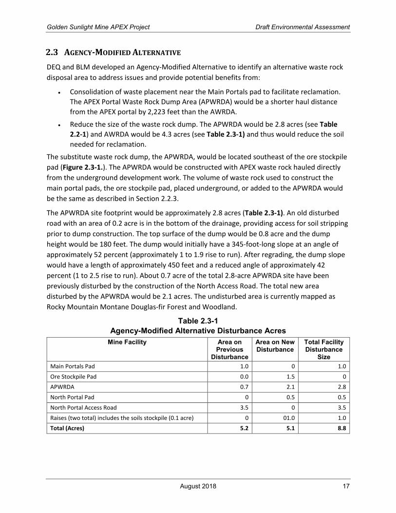
AGENCY-MODIFIED ALTERNATIVE
DEQ and BLM developed an Agency-Modified Alternative to identify an alternative waste rock
disposal area to address issues and provide potential benefits from:
• Consolidation of waste placement near the Main Portals pad to facilitate reclamation.
The APEX Portal Waste Rock Dump Area (APWRDA) would be a shorter haul distance
from the APEX portal by 2,223 feet than the AWRDA.
• Reduce the size of the waste rock dump. The APWRDA would be 2.8 acres (see Table
2.2-1) and AWRDA would be 4.3 acres (see Table 2.3-1) and thus would reduce the soil
needed for reclamation.
The substitute waste rock dump, the APWRDA, would be located southeast of the ore stockpile
pad (Figure 2.3-1.). The APWRDA would be constructed with APEX waste rock hauled directly
from the underground development work. The volume of waste rock used to construct the
main portal pads, the ore stockpile pad, placed underground, or added to the APWRDA would
be the same as described in Section 2.2.3.
The APWRDA site footprint would be approximately 2.8 acres (Table 2.3-1). An old disturbed
road with an area of 0.2 acre is in the bottom of the drainage, providing access for soil stripping
prior to dump construction. The top surface of the dump would be 0.8 acre and the dump
height would be 180 feet. The dump would initially have a 345-foot-long slope at an angle of
approximately 52 percent (approximately 1 to 1.9 rise to run). After regrading, the dump slope
would have a length of approximately 450 feet and a reduced angle of approximately 42
percent (1 to 2.5 rise to run). About 0.7 acre of the total 2.8-acre APWRDA site have been
previously disturbed by the construction of the North Access Road. The total new area
disturbed by the APWRDA would be 2.1 acres. The undisturbed area is currently mapped as
Rocky Mountain Montane Douglas-fir Forest and Woodland.
Table 2.3-1
Agency-Modified Alternative Disturbance Acres
Mine Facility Area on Previous
Disturbance
Area on New Disturbance
Total Facility Disturbance
Size
Main Portals Pad 1.0 0 1.0
Ore Stockpile Pad 0.0 1.5 0
APWRDA 0.7 2.1 2.8
North Portal Pad 0 0.5 0.5
North Portal Access Road 3.5 0 3.5
Raises (two total) includes the soils stockpile (0.1 acre) 0 01.0 1.0
Total (Acres) 5.2 5.1 8.8

Golden Sunlight Mine APEX Project Draft Environmental Assessment
August 2018 18
Figure 2.3-1. Agency-Modified Alternative

Golden Sunlight Mine APEX Project Draft Environmental Assessment
August 2018 19
Growth media would be salvaged from the undisturbed 2.1 acres designated for the proposed
APWRDA and stockpiled below the site along the North Access Road. This stockpile location
would be convenient for reclaiming the APWRDA because it is adjacent to the North Access
Road and the growth media could be easily hauled to the top of the APWRDA for spreading.
The growth media stockpile would be situated on a previously disturbed area. Assuming one
foot of salvageable growth media across the 2.1 acres, the estimated volume of growth media
in the APWRDA soil stockpile would be 4,800 cubic yards.
Growth media would be hauled from the stockpile approximately 3,100 feet to the top center
of the APWRDA for spreading on the regraded dump slopes. Additional growth media would be
needed to achieve the desired soil depth under the approved Golden Sunlight Mine
reclamation plan. Growth media would be placed to a depth of approximately 31 inches over
the APWRDA slopes and faces for reclamation. Additional growth media is available at the
Golden Sunlight Mine and would most likely come from the West Side growth media stockpiles.
After the APWRDA top and slopes have received growth media, the areas would be seeded and
fertilized as specified in Golden Sunlight Mine’s reclamation plan.
Golden Sunlight Mine has previously addressed waste rock stability issues at this mine and
would use additional geotechnical factors in designing the APWRDA.
2.3.1 Mining, Water Management, and Roads
The APWRDA is approximately 2,000 feet closer to the Main Portals than the AWRDA in the
Proposed Action.
2.3.2 Waste Rock Storage
Waste rock would be managed the same as in the Proposed Action.
Some potentially acid generating (PAG) waste rock would be placed underground so the
volume of waste rock to store aboveground would be less than 250,000 tons. The APWRDA size
would be 2.8 acres instead of the 4.3-acre AWRDA so there would be less impacts associated
with the smaller footprint. The smaller APWRDA would require slightly less growth media to
cap, but the regrading efforts would be similar. The alternative is technically feasible because
the area is readily accessible and would be approximately 2,000 feet closer to the main portals.
2.3.3 Growth Media Stockpiles
Growth media stockpiles and reclamation growth media volumes for the disturbed areas would
be adjusted accordingly. The APWRDA would require a 31-inch growth media cover, amended
with fertilizer and compost on this PAG rock. The proposed 4.3-acre AWRDA would require an
estimated 17,222 cubic yards of growth media to cover the entire waste rock dump; the
substitute 2.8-acre APWRDA would require an estimated 11,214 cubic yards of growth media.
Only 4,800 cubic yards of growth media would be salvaged from the APWRDA; therefore,
approximately 6,414 cubic yards of growth media would need to be hauled from the West Side
growth media stockpiles. Growth media hauling distances would be approximately 3,100 feet

Golden Sunlight Mine APEX Project Draft Environmental Assessment
August 2018 20
for growth media in the APWRDA stockpile and 5,645 feet from the West Side growth media
stockpile.
ALTERNATIVES CONSIDERED BUT NOT STUDIED IN DETAIL
DEQ and BLM reviewed other alternatives to determine if they would provide significant
environmental benefit, would be achievable under current technology, and would be
economically feasible (for similar projects having similar conditions and physical locations)
under Section 75-1-201 (1)(b)(iv)(C)(I), MCA.
2.4.1 Use of Existing Waste Rock Dumps Alternative
DEQ and BLM considered eliminating the AWRDA and using an existing waste rock dump for
disposal of the 250,000 tons of waste rock generated from the APEX underground mining.
Potential benefits considered were from consolidating waste rock for reclamation, reducing the
quantity of growth media needed for reclamation, and improving the reclamation schedule.
After further review, this potential alternative was dismissed because it would result in
additional visual impacts to the existing dumps, the construction of an additional staging area
for storing and transferring rock before disposal, and longer waste rock and growth media
hauling distances. The added height would be visible from several vantage points and the
longer hauling distances would result in increased fuel consumption and greater releases of
greenhouse gases and total emissions. Additionally, the 4.3-acre area designated for the
AWRDA has been previously disturbed and would still require reclamation or grading, applying
growth media application, and seeding.
2.4.2 Relocation of the Main Portal Alternative
This alternative would relocate the Main Portals to the edge of the existing Mineral Hill Pit and
was considered by DEQ and BLM to be technically feasible.
This alternative would entail relocating the two Main Portals and extending the adit length by
approximately 2,000 feet, creating more waste rock. The Main Portal adits would incline for
their initial lengths to preclude surface runoff from entering the mine. The relocated main
portals would provide a more direct discharge of any mine water to Mineral Hill Pit.
Underground development could change due to accessing the ore body from a lower elevation
and could affect the overall mine plan (stopes and raises).
Relocating the Main Portal addresses the following issues:
• Minimize surface disturbance;
• Provide direct discharge of mine water to Mineral Hill Pit; and
• Meet requirements of MCA 75-1-220(1).
Relocating the Main Portal to the Mineral Hill Pit would extend the adit length by approximately
2,000 feet creating more waste rock for disposal. Underground mine development plans could

Golden Sunlight Mine APEX Project Draft Environmental Assessment
August 2018 21
change. Potential mine water encountered from the underground workings would be directly
discharged to the Mineral Hill Pit whereas the Proposed Action anticipates capturing any mine
water with a designed system or possibly a dewatering well and delivering it to the Mineral Hill
Pit via a pipeline or ditch. Relocating the Main Portal to the Mineral Hill Pit was not considered
in detail because it would not provide a significant environmental benefit.
SUMMARY COMPARISON OF ALTERNATIVES
Table 2.6-1 summarizes the results of the impact analysis, which are described in more detail in
Section 3.
AGENCIES PREFERRED ALTERNATIVE
DEQ and BLM have identified the Agency-Modified Alternative as the preferred alternative. This
is only the Preferred Alternative for the Draft EA. A final decision will be issued in a decision
document after issuance of the Final EA.

Golden Sunlight Mine Apex Project Environmental Assessment
April 2018 22
Table 2.6-1
Summary of Direct and Secondary Impacts
Resource No Action Alternative Proposed Action Alternative Agency-Modified Alternative
Soil and
Reclamation
Soil
Under the No Action Alternative, no
additional disturbance and no soil
salvage operations would occur. The
reclamation plan and schedule would
not change. Soil stability would remain
unaffected.
Soil
Soil would be susceptible to erosion during
handling and storage and would exhibit
decreased productivity upon replacement in
reclaimed areas. These impacts would be minor
and long-term.
Soil
The potential for and impacts from erosion
would be the same as the Proposed Action.
Soil and
Reclamation
Reclamation Schedule
The current reclamation schedule
would remain the same.
Reclamation Schedule
The APEX amendment would require continued
use of some areas (roads, AWRDA, soil
stockpiles, etc.) for three additional years. This
would be a minor, short-term effect on the
reclamation schedule.
Reclamation Schedule
The impacts on the reclamation schedule
would be the same as the Proposed Action.
Water Surface Water
Over the long-term and as more
project facilities are reclaimed and
vegetation on reclaimed surfaces
becomes more dense, ephemeral
surface water runoff rates would likely
decrease.
Surface Water
Surface water runoff volume would likely
increase negligibly during construction as more
ground surface is made impermeable. No
impact on surface water quality would occur,
and the ground water recharged by infiltration
would see a negligible, short-term decrease
during construction and through reclamation.
Surface Water
The impacts on surface water resources from
the Agency-Modified Alternative would be
the same as the Proposed Action except for a
negligible decrease in runoff potential and
seasonal discharge, and a negligible increase
of infiltration due to the increased
disturbance area and reduction of slope.
Water Ground Water
Ground water flow paths would
remain the same, and the ground
water pumping and capture systems
on the site are already designed to
address impacts from current
operations.
Ground Water
The project would be completed entirely above
the water table and ground water flow paths
are documented to be highly
compartmentalized, internal mine discharge to
the groundwater system would likely be
negligible and long-term.
A minimal discharge of potentially mineralized
acidic water would experience dilution and
Ground Water
The impacts on ground water resources from
the Agency-Modified Alternative would be
the same as the Proposed Action except for a
negligible, short-term increase of recharge by
infiltration due to the reduction of slope.

Golden Sunlight Mine Apex Project Environmental Assessment
August 2018 23
Resource No Action Alternative Proposed Action Alternative Agency-Modified Alternative
attenuation in the unsaturated zone and result
in a negligible effect on local water quality. If
mineralized water accumulates within the
underground mine workings, it would be
collected in a dewatering well, or a pump in the
ventilation raise, to avoid water quality impacts.
Water Springs
No impact on springs.
Springs
Proposed Action would have a negligible, long-
term effect on the Microwave and Sheep spring
complexes for both discharge volume and water
quality.
Potential further reduction of Beaver Springs
discharge during construction due to the
Proposed Action would be negligible and short-
term based on the catchment area above this
spring.
Springs
The impacts on springs from the Agency-
Modified Alternative would be the same as
the Proposed Action.
Vegetation No impact on vegetation resources. mpacts on special status plants would not
occur. There would be no direct impact on
wetlands.
. Special status plant species and wetlands
would not be affectedSpecial status plant
species and wetlands would not be affected.
Wildlife There would be no effect on wildlife
resources.
There would be a short-term loss of a negligible
amount of wildlife habitat (less than one
percent of the analysis area), which would be
reclaimed. No impacts are expected from
ventilation system noise, powerline
electrocution, or ground subsidence. No
indirect or secondary impacts on wildlife are
expected to occur. Mitigation measures on the
timing of activities would ensure no direct loss
of nesting birds or roosting bats. For these
reasons, the Proposed Action would have
negligible, short-term impacts on wildlife.
Impacts on wildlife resources under the
Agency-Modified Alternative would be the
same as the Proposed Action except an
additional 2.1 acres of wildlife habitat (less
than one percent of the analysis area) would
be lost to disturbance in the short-term.
Reclamation would return the habitat to a
wildlife habitat land use following completion
of mining activities. Noise and traffic
disturbance would be less than the Proposed
Action because of the shortened haul route.
Mitigation measures would be the same as
the Proposed Action. With implementation of

Golden Sunlight Mine Apex Project Environmental Assessment
August 2018 24
Resource No Action Alternative Proposed Action Alternative Agency-Modified Alternative
mitigation measures and reclamation,
impacts on wildlife would be negligible.
Socioeconomics Tax Revenue
Metal Mines tax of about $800,000
annually would cease in December
2018. The loss of Metal Mine Tax
revenue from Golden Sunlight would
be 6 to 9 percent of the total Metal
Mine Tax paid, the loss of which would
be moderate and long-term.
Tax Revenue
Golden Sunlight Mine would continue to pay
approximately $800,000 in Metal Mine Tax
annually to the State for three years. Golden
Sunlight Mine would continue to pay property
taxes at a rate similar to 2017 for an additional
three years.
Tax Revenue
Impacts on tax revenue would be the same as
the Proposed Action.
Socioeconomics Legacy Milling
Legacy milling would cease. The impact
on revenue for small miners and the
added environmental benefit from the
removal of historic waste would be
moderate and long-term.
Legacy Milling
Legacy milling would continue.
Legacy Milling
Impacts would be the same as the Proposed
Action.
Socioeconomics Employment and Income
Approximately 140 Barrick and
contract employees would no longer
be employed at the mine, although a
smaller work force would be retained
for reclamation and site management.
The loss of 140 employees and their
income would be about 8 percent of
the total employment in Jefferson
County. This level of change would be
moderate and long-term.
Employment and Income
Employment of approximately 140 employees
would continue for three more years. This
would be a negligible and short-term effect.
Employment and Income
Impacts would be the same as the Proposed
Action.
Golden Sunlight Mine Apex Project Environmental Assessment
April 2018 25
SECTION 3. AFFECTED ENVIRONMENT AND ENVIRONMENTAL
CONSEQUENCES
INTRODUCTION
This section describes the affected environment of resources near the project, the area of
analysis for each, and both positive (beneficial) and negative (adverse) impacts resulting from
each of the alternatives on the resources.
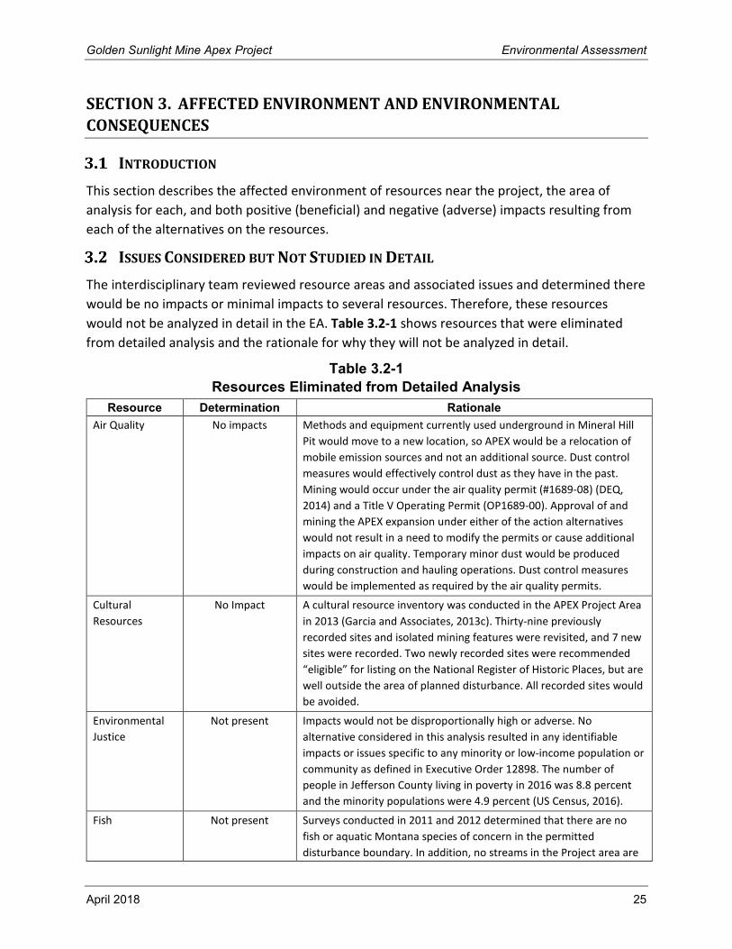
ISSUES CONSIDERED BUT NOT STUDIED IN DETAIL
The interdisciplinary team reviewed resource areas and associated issues and determined there
would be no impacts or minimal impacts to several resources. Therefore, these resources
would not be analyzed in detail in the EA. Table 3.2-1 shows resources that were eliminated
from detailed analysis and the rationale for why they will not be analyzed in detail.
Table 3.2-1
Resources Eliminated from Detailed Analysis
Resource Determination Rationale
Air Quality No impacts Methods and equipment currently used underground in Mineral Hill
Pit would move to a new location, so APEX would be a relocation of
mobile emission sources and not an additional source. Dust control
measures would effectively control dust as they have in the past.
Mining would occur under the air quality permit (#1689-08) (DEQ,
2014) and a Title V Operating Permit (OP1689-00). Approval of and
mining the APEX expansion under either of the action alternatives
would not result in a need to modify the permits or cause additional
impacts on air quality. Temporary minor dust would be produced
during construction and hauling operations. Dust control measures
would be implemented as required by the air quality permits.
Cultural
Resources
No Impact A cultural resource inventory was conducted in the APEX Project Area
in 2013 (Garcia and Associates, 2013c). Thirty-nine previously
recorded sites and isolated mining features were revisited, and 7 new
sites were recorded. Two newly recorded sites were recommended
“eligible” for listing on the National Register of Historic Places, but are
well outside the area of planned disturbance. All recorded sites would
be avoided.
Environmental
Justice
Not present Impacts would not be disproportionally high or adverse. No
alternative considered in this analysis resulted in any identifiable
impacts or issues specific to any minority or low-income population or
community as defined in Executive Order 12898. The number of
people in Jefferson County living in poverty in 2016 was 8.8 percent
and the minority populations were 4.9 percent (US Census, 2016).
Fish Not present Surveys conducted in 2011 and 2012 determined that there are no
fish or aquatic Montana species of concern in the permitted
disturbance boundary. In addition, no streams in the Project area are

Golden Sunlight Mine Apex Project Environmental Assessment
August 2018 26
Resource Determination Rationale
identified as occupied streams in the state-wide fish distribution map
data produced by Montana Fish, Wildlife, and Parks (Montana Fish,
Wildlife, and Parks, 2017). All streams in the Project area are
headwater streams that have intermittent flow (i.e., only during
spring snow melt and storm events), and thus do not provide suitable
habitat for fish. Water discharged offsite would be treated to meet
state water quality standards and would not affect downstream
aquatic resources. There are no threatened, endangered, or candidate
fish species occupying the action area (BLM, 2013).
Land Use Negligible Impacts The potential areas restricted from grazing access would be limited to
the areas fenced for safety and total less than 0.2 acre. This level of
exclusion would not affect land uses to a noticeable degree. Impacts
on land use would be negligible.
Native American
Religious
Concerns
Not present The BLM Butte Field Office regularly meets with tribal governments
and provides a fiscal year project list for review by tribal
representatives. Government-to-government meetings are held when
project matters are elevated from routine discussion. Various stages
of the APEX project have been under review by the BLM since 2012
and have been a component of tribal meetings. Because the proposed
project activities would only disturb approximately 5 surface acres
that contain no prehistoric cultural resources, the APEX project has
not been elevated to government-to-government status by any of the
consulted tribes. The following list represents face-to-face meetings
where the APEX project was included in the project list discussions:
General interest meetings with the Confederated Salish and Kootenai
Tribes in February 2012; June 2013; July 2014; June 2015; and April
2017.
General interest meetings with Shoshone-Bannock Tribes in May
2013; April 2015; April 2016; and April 2017.
General interest meeting with the Crow Nation Tribal Historic
Preservation Officer in July 2016.
General interest meeting with Tribal Historic Preservation Officer,
Blackfeet Nation in April 2012. (Personal Communication from Carolyn
Kiely, BLM Archaeologist, on April 4, 2018).
Noise No impacts There are no sensitive receptors or residences near the mine area.
(Noise impacts on Wildlife are discussed in Section 3.6).
Paleontological Not Present No paleontological resources have been found in more than 42 years
of mining.
Recreation Negligible impacts Golden Sunlight Mine's proposed surface facilities, consisting of the
north portal and/or raises would not affect recreational access or
opportunities in the area. The potential restricted areas would be
limited to the areas fenced for safety and would be less than 0.2 acre.
Vehicle access is already restricted through the mine. Non-motorized
access from the west or the north into the Bull Mountains would not
be changed. Impacts on recreation would be negligible.
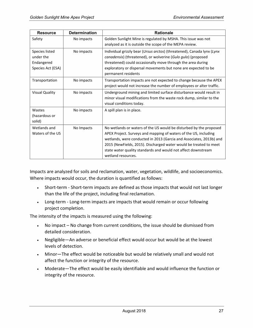
Golden Sunlight Mine Apex Project Environmental Assessment
August 2018 27
Resource Determination Rationale
Safety No impacts Golden Sunlight Mine is regulated by MSHA. This issue was not
analyzed as it is outside the scope of the MEPA review.
Species listed
under the
Endangered
Species Act (ESA)
No impacts Individual grizzly bear (Ursus arctos) (threatened), Canada lynx (Lynx
canadensis) (threatened), or wolverine (Gulo gulo) (proposed
threatened) could occasionally move through the area during
exploratory or dispersal movements but none are expected to be
permanent residents
Transportation No impacts Transportation impacts are not expected to change because the APEX
project would not increase the number of employees or alter traffic.
Visual Quality No impacts Underground mining and limited surface disturbance would result in
minor visual modifications from the waste rock dump, similar to the
visual conditions today.
Wastes
(hazardous or
solid)
No impacts A spill plan is in place.
Wetlands and
Waters of the US
No Impacts No wetlands or waters of the US would be disturbed by the proposed
APEX Project. Surveys and mapping of waters of the US, including
wetlands, were conducted in 2013 (Garcia and Associates, 2013b) and
2015 (NewFields, 2015). Discharged water would be treated to meet
state water quality standards and would not affect downstream
wetland resources.
Impacts are analyzed for soils and reclamation, water, vegetation, wildlife, and socioeconomics.
Where impacts would occur, the duration is quantified as follows:
• Short-term - Short-term impacts are defined as those impacts that would not last longer
than the life of the project, including final reclamation.
• Long-term - Long-term impacts are impacts that would remain or occur following
project completion.
The intensity of the impacts is measured using the following:
• No impact – No change from current conditions, the issue should be dismissed from
detailed consideration.
• Negligible—An adverse or beneficial effect would occur but would be at the lowest
levels of detection.
• Minor—The effect would be noticeable but would be relatively small and would not
affect the function or integrity of the resource.
• Moderate—The effect would be easily identifiable and would influence the function or
integrity of the resource.

Golden Sunlight Mine Apex Project Environmental Assessment
August 2018 28
SOIL AND RECLAMATION
3.3.1 Affected Environment
A soils baseline assessment was completed in the area proposed for construction of APEX
project facilities to verify Natural Resources Conservation Service (NRCS) soil mapping. The
assessment included submittal of soil samples for laboratory analysis (Garcia and Associates,
2013a). The assessment concluded the NRCS mapping was accurate and that the following two
soil mapping units are present in areas that would be disturbed by the APEX project:
• Mapping unit 1143F, Deville-Wilde-Rock outcrop, complex. Located in the Main Portals
and raises areas.
• Mapping unit 1760E, Hanson, stony-Whitore, bouldery, complex. Located in the North
Portal Area.
Soils within mapping unit 1143F weathered from shale and siltstone residuum and colluvium
and have a high content of coarse fragments (NRCS, 2018). These soils are sandy and shallow
with an average depth to bedrock of 13.4 inches (Garcia and Associates, 2013a). Acid/base
potential data measured during the baseline assessment indicated that these soils may be acid-
producing.
Soils within mapping unit 1760E weathered from gravelly limestone colluvium and alluvium and
have a high content of coarse fragments (NRCS, 2018). These soils were determined to be the
most suitable for use in reclamation due to their location, texture, relative thickness (22 inches
average depth), and carbonate content (Garcia and Associates, 2013a).
3.3.2 Analysis Area
The analysis area for soil resources and reclamation includes areas where soil would be
removed for salvage and/or replaced during reclamation (Figure 3.3-1.). These areas are the
North Portal Area, Main Portals Area, raises, ore stockpile, and AWRDA. Access roads are not
included in this analysis because roads that would be used to access the APEX project already
exist and the plan for their reclamation is currently approved.
3.3.3 Environmental Consequences
The following issues related to soil resources and reclamation were identified and are
addressed below for the No Action and Proposed Action Alternatives:
• Would there be enough soil available for reclamation?
• Would the approved reclamation schedule need to be adjusted?
• Would reclamation be satisfactory if the mine closes early or temporarily?
• Would there be soil stability problems at waste disposal sites?

Golden Sunlight Mine Apex Project Environmental Assessment
August 2018 29
Figure 3.3-1. Resource Analysis Areas

Golden Sunlight Mine Apex Project Environmental Assessment
August 2018 30
3.3.3.1 No Action Alternative
Under the No Action Alternative, the proposed APEX expansion would not be approved, and no
disturbances would occur beyond those currently authorized by Operating Permit 00065.
Impacts from these disturbances were analyzed and described in the 2013 Environmental
Impact Statement (EIS) and generally consist of a reduction in beneficial physical, chemical, and
biological properties at disturbed areas (DEQ, 2013). Increased potential for soil erosion from
disturbed areas and soil stockpiles was also predicted.
Under the No Action Alternative, no additional disturbance and no soil salvage operations
would occur. The reclamation plan and schedule would not change. Soil stability would remain
unaffected.
Reclamation Schedule
The current reclamation schedule would not need to be adjusted.
3.3.3.2 Proposed Action Alternative
Under the Proposed Action Alternative, soil would be removed from the North Portal area, the
Main Portals area, raises areas, the ore stockpile area, and the AWRDA. Soil would be stripped
from approximately 109,000 square feet (2.5 acres) of new disturbance during construction of
the North Portal, Main Portals, and raises (Table 3.3-1). Reclamation of these areas would
require replacement of the salvaged soil. Construction of the ore stockpile and the AWRDA
would occur on approximately 253,000 square feet (5.8 acres) of previously disturbed ground
which is currently devoid of soil. Reclamation of these facilities would include replacing the soil
stripped during previous construction, which would be hauled from the existing Interim2 soil
stockpile.
Table 3.3-1
APEX Project Soil Disturbance for Construction and Reclamation
Disturbance Soil Stripped (Square
Feet)
Soil Stripped (Inches)
Soil Stripped (Cubic Yards)
Soil Replaced (Square
Feet)
Soil Replaced (Inches)
Soil Replaced
(Cubic Yards)
North Portal Pad 21,780 22 1,481 21,780 22 1,481
Main Portals Pad 43,560 13.4 1,852 43,560 33.4 4,552b
Raises 43,560 13.4 1,852 43,560 23.4 3,252b
Ore Stockpile Pad 0a 0a 0a 65,340 31 6,300b
AWRDA 0a 0a 0a 187,500 31 17,940b
Total 108,900 -- 5,185 361,740 -- 33,525
a Ore Stockpile Pad and AWRDA would be constructed on previously disturbed area and therefore no soil is present for
stripping.
b Soil for reclamation of Ore Stockpile Pad, AWRDA, and 4,100 cubic yards of soil for Main Portals and raises would be
hauled from the existing Interim2 soil stockpile.
Golden Sunlight Mine Apex Project Environmental Assessment
August 2018 31
Soil handling and stockpile operations would result in the degradation of soil structure which is
a key factor affecting soil-water interactions, erosion, nutrient cycling, susceptibility to
compaction, and the support of plant life (Bronick & Lal, 2004). Soil would be susceptible to
erosion during handling and storage and would exhibit decreased productivity upon
replacement in reclaimed areas. Although soil salvage and replacement activities are designed
to minimize the loss of soil functionality through soil amendment and erosion prevention
measures, these impacts would be minor and long-term.
All soil stripped from a disturbance area would be stockpiled and used for reclamation at the
completion of the project. Approximately 28,340 cubic yards of additional soil from the existing
Interim2 soil stockpile would be used to augment soil returned to the Main Portals areas and
would also be used to cap the ore stockpile area and the AWRDA. A portion of stockpiled soil
would be expected to be lost to erosion. However, a total of 51,843 cubic yards of soil are
available for reclamation in the Interim2 stockpile. Therefore, adequate soil would be available
for reclamation and impacts related to reclaimed soil thicknesses would be negligible and long-
term.
Soil salvage and stockpiling would occur as the first step during facility construction and
stockpiles would be seeded to stabilize them against erosion until they are used for
reclamation. For this reason, and because the Interim2 stockpile is already present, soil would
be available for use in reclamation whenever it is needed regardless of mine closure schedule.
Reclamation Schedule
The mine would continue to operate for three more years. Some areas would continue to be
reclaimed as their use is completed. The APEX amendment would require continued use of
some areas (roads, AWRDA, soil stockpiles, etc.) for three additional years. This would be a
minor, short-term effect on the reclamation schedule.
3.3.3.3 Agency-Modified Alternative
For the Agency-Modified Alternative, growth media removal and stockpiling for construction
and eventual reclamation of the North Portal area, Main Portals area, raises areas, and ore
stockpile area would be the same as the proposed action.
Approximately 12 inches of soil would be stripped from 2.3 acres to construct the APWRDA.
This soil would be stockpiled adjacent to the dump in a previously disturbed area. The soil
salvaged from the APWRDA area, along with additional soil hauled from existing soil stockpiles
(likely the West Side stockpiles), would be used to cover the APWRDA (121,968 square feet)
with 18 inches of growth media per the approved Golden Sunlight Mine reclamation plan.
The potential for and impacts from erosion would be the same as the Proposed Action.

Golden Sunlight Mine Apex Project Environmental Assessment
August 2018 32
Reclamation Schedule
The impacts on the reclamation schedule would be the same as the Proposed Action. The mine
would continue to operate for three more years. This delay in reclamation would result in some
acres remaining in a disturbed condition for up to three years longer. This would be a minor,
short-term effect on the reclamation schedule.
WATER
3.4.1 Analysis Area
The analysis area for water includes areas within the permit boundary, the proposed Mine
Boundary Extension, and the topographic ridge north of the proposed Disturbance Boundary.
3.4.2 Affected Environment
3.4.2.1 Surface Water
The APEX project is located at the surface water drainage divide for the ephemeral headwaters
of St. Paul Gulch to the west, Conrow Creek to the north, and Sheep Rock Gulch to the east.
Elevations range from 5,350 feet in drainage bottoms to over 7,000 feet along the ridge. Site
data indicates average annual precipitation for the project area is approximately 16.6 inches
with the majority occurring April through June. Surface water runoff when present is associated
with seasonal events (i.e. snow melt) or localized short duration high intensity precipitation
events.
3.4.2.2 Ground Water
The APEX project area is located on a topographic ridge, oriented northwest to southeast. This
topographic ridge also forms the hydrologic divide. Ground water recharge is limited to
infiltration of precipitation and snowmelt. The catchment area near the project is
approximately 500 acres. Potential recharge is estimated to be approximately 15 percent of
annual precipitation, resulting in approximately 64 gallons per minute for the entire 500-acre
catchment area, with the majority assumed to contribute to the local ground water system.
Within the project area where the underground workings would be developed, ground water
recharge is estimated at approximately 1.5 gallons per minute. Ground water flow generally
follows surface topography, ultimately flowing to the south to the Jefferson River. Due to low
primary permeability structural controls and lithologic contacts, the bedrock is
compartmentalized and ground water flow through the bedrock is believed to be limited.
Ground water is primarily contained in fractures within the bedrock aquifer with potential
localized flow both to the east and west.
Two fault systems are present in the project area. The APEX fault system is oriented east to
west and passes through the proposed workings while the Siesta Fault is oriented north south
and forms the eastern project boundary. Based on ground water elevation data and well
production data recorded during well installation, the APEX fault system is not a hydrologic

Golden Sunlight Mine Apex Project Environmental Assessment
August 2018 33
barrier whereas the Siesta Fault appears to be a barrier limiting ground water flow to the east.
Ground water beneath the project area is expected to discharge either to the west to shallow
alluvium in St. Paul Gulch, or to the south into the Mineral Hill Pit. Geologic structures to the
west of the Project have not been investigated in detail.
Long term pumping of the Mineral Hill Pit may have dewatered portions of the Project area
prior to collection of data for the Proposed Action. Baseline ground water elevation
measurements completed from 2013 through November 2016 indicate the ground water
elevation in the APEX Project area is between 5,660 feet to 5,688 feet. The lowest elevation of
proposed underground workings is 5,750 feet which provides at least 60 feet of buffer above
the ground water level.
Limited localized perched ground water has been documented in several exploration drill holes
throughout the site with short term discharge rates of up to 150 gallons per minute entering
the drill holes during their completion. Many drill holes exhibited significantly lower static
water levels or were dry during subsequent monitoring events. Therefore, potential inflows
from perched water are anticipated to dissipate or subside quickly due to the limited storage
capacity and connectivity of fractures.
3.4.2.3 Springs
Two perennial spring complexes (Microwave and Sheep) are located along the ephemeral
Sheep Rock drainage to the east of the project. Springs are expressed at surface elevations
above the ground water elevation in the area and are perched on clayey sediments. Discharge
from these springs is generally less than 1 gallon per minute and flows short distances before
infiltrating to native soil. All springs of the Sheep Rock drainage are located east of the Siesta
Fault. Differences in water level measurements and estimated discharge during installation of
wells on both sides of the Siesta Fault indicate this structure is a hydrologic barrier restricting
ground water flow in an east-west direction. Based on this evidence, source water to springs in
the Sheep Rock drainage is concluded to be ground water sourced from the topographic high to
the east.
Beaver Springs is the only spring identified to the west of the project. Data indicates the spring
has not flowed for several years but remains a wet area. A reduction of this spring’s discharge is
due in part to variations in precipitation.
3.4.3 Environmental Consequences
3.4.3.1 No Action Alternative
Surface Water
Current surface water drainage patterns and runoff volumes and rates would remain
substantially as they are now. Over the long-term and as more project facilities are reclaimed
and vegetation on reclaimed surfaces becomes more dense, ephemeral surface water runoff

Golden Sunlight Mine Apex Project Environmental Assessment
August 2018 34
rates would likely decrease. Golden Sunlight Mine would maintain surface water runoff
features on the mine site post-closure. Impacts on surface water from the No Action Alternative
would be negligible and long-term.
Ground Water
Ground water flow paths would remain the same, and the ground water pumping and capture
systems on the site are already designed to address impacts from current operations. Golden
Sunlight Mine would maintain ground water pumping and capture systems post-closure.
Springs
Water source, flow path, and location of springs would remain the same. Discharge quantities
would continue to fluctuate naturally. No impact on springs would occur from the No Action
Alternative.
3.4.3.2 Proposed Action Alternative
Surface Water
Surface disturbance totaling 11.8 acres (9.3 acres previously disturbed plus 2.5 additional acres)
(Golden Sunlight Mine, Inc., 2017) would consist of compacted lower permeability surfaces
such as roads and portal pads. These surfaces would increase localized runoff volume from
rainfall and snowmelt and decrease the volume that infiltrates to the ground water system
during construction. A permanent run-on control ditch currently exists on the North Access
Road and would continue to be used to capture surface water runoff from the proposed portal
pad and access road on the south side of the APEX expansion area. Storm water flow would
follow the current drainage, would be routed to an existing sediment basin found below the
East Area reclaimed overburden, and would be allowed to infiltrate and/or evaporate. As
described in the Storm Water Pollution Prevention Plan, sediment basins are typically used in
conjunction with straw bales, infiltration swales, and diffusers (Golden Sunlight Mine, Inc,
2018). Lime may be added to control acidity where necessary. Many of the larger sediment
traps also serve as infiltration areas, with the infiltrating water included under a site-wide
groundwater mixing zone approved in 1998 (DEQ, 1998).
Runoff to area ephemeral drainages during construction would be reduced from that naturally
occurring by storm water diversions. Annual potential evaporation is approximately 41 inches
per year which exceeds average annual precipitation of approximately 14 to 16 inches per year
(Gallagher, 2017). Infiltration to ground water (estimated to be 15% of precipitation) would be
further reduced in areas where construction results in compacted surfaces. Because the project
would only affect approximately 2.5 acres of previously undisturbed land, the impact to
groundwater recharge is projected to be negligible. Following reclamation, the revegetated
disturbed areas would result in surface runoff and infiltration volume similar to pre-
disturbance. Established sediment control features and best management practices would

Golden Sunlight Mine Apex Project Environmental Assessment
August 2018 35
control runoff from the six acres of disturbed area of the north portal pad and associated access
road.
During construction and prior to reclamation, the surface of the waste rock disposal area
(AWRDA) would be highly permeable and unvegetated which would result in infiltration rates
greater than undisturbed areas. Little or no contribution to ground water recharge is
anticipated from infiltration through the waste rock. This is because the toe of the AWRDA
slope would overlie existing compacted road surfaces which are likely to prevent seepage into
ground water. Furthermore, the limited amount of infiltration entering the waste rock during
the few years prior to its reclamation is likely to be absorbed by the waste rock. Surface runoff
and seasonal discharges would be captured by existing features and routed to the Mineral Hill
Pit to infiltrate or evaporate. Following reclamation and revegetation there would be an
increase in evapotranspiration and reduction of surface runoff.
Surface water runoff volume would likely increase negligibly during construction as more
ground surface is made impermeable. No impact on surface water quality would occur, and the
ground water recharged by infiltration would see a negligible, short-term decrease during
construction and through reclamation.
Ground water
Localized water management in the form of grouting to stop water from entering the workings,
allowing water to gravity drain from the Main Portal and routing it to the Mineral Hill Pit, or
installing a dewatering pump in the ventilation raise and pumping water to the Mineral Hill Pit
would minimize the amount of potentially acidic water that may seep into the ground water
system beneath the underground mine workings.
Drainage of perched water encountered by phase 1 and phase 2 developments via a south
portal is possible. During construction and post construction, water collected by phase 1 and
phase 2 developments would gravity drain to the portal, where it would be captured and
routed to the Mineral Hill Pit. The capture and transmittal system may include a ditch or
pipeline with valves to control flow and is anticipated to be an effective means to transmit
water to the Mineral Hill Pit for treatment. Water encountered during construction of the
phase 3 decline would likely be operationally consumed or pumped to the Mineral Hill Pit using
the same pipeline as the portal drainage. Post construction, water encountered by phase 3
workings would likely drain internally to the lower workings. This water would then either seep
out of the lower workings and enter the ground water system, or it would collect in the
workings and be pumped out for treatment.
There would be at least a 60 feet separation between the lowest workings and the ground
water level in the area. Therefore, there would be no direct dewatering impacts on the regional
water level. Potential mine dewatering of perched or local compartmentalized ground water
would indirectly reduce the volume of water reaching the ground water system by
approximately 1.5 gallons per minute during construction.

Golden Sunlight Mine Apex Project Environmental Assessment
August 2018 36
Increased runoff and diversion of runoff water away from the project area would reduce
infiltration rates within the project area, which would also indirectly reduce the volume of
ground water recharge. These localized reductions in ground water recharge would result in a
negligible, short-term decrease in the local ground water level.
Structural controls such as faults and fractures would continue to control ground water flow
direction during and after construction.
Due to direct infiltration of precipitation into the adits, discharge of up to 1.5 gallons per
minute from the south portals may occur during phase 1 and phase 2 construction and during
post construction. If Portal discharge is present or if localized underground dewatering is
necessary, water would be routed to the Mineral Hill Pit for capture and subsequent water
treatment. As currently designed, the water treatment facility permitted under Amendment 10
has adequate capacity to accept the negligible 1.5 gallons per minute volume and chemistry
potentially produced by this project.
Completion of the phase 3 decline would likely allow this portion of the mine to drain internally
to the lower workings. The project would be completed entirely above the water table and
ground water flow paths are documented to be highly compartmentalized, internal mine
discharge to the groundwater system would likely be negligible and long-term.
Of the total estimated 1.5 gallons per minute infiltration to the project area, the percentage
expressed as discharge from portals is unknown. Therefore, internal mine drainage is estimated
to be up to 1.5 gallons per minute, which could reenter the local ground water system though
dry fractures in the mine floor. A minimal discharge of potentially mineralized acidic water to
the local ground water system would experience dilution and attenuation in the unsaturated
zone, resulting in a negligible, long-term effect on local water quality. In the unlikely event that
inflow to the mine exceeds projected rates and/or does not seep into the mine floor as
anticipated, water would be extracted using a pump and dewatering well constructed in the
ventilation raise to avoid water quality impacts to ground water.
Springs
Due to the fracture and flow path compartmentalization identified for the ground water system
in the mine area, and source water of springs originating from outside the mine area, the
Proposed Action would have a negligible, long-term effect on the Microwave and Sheep spring
complexes for both discharge volume and water quality.
Potential further reduction of Beaver Springs discharge during construction due to the
Proposed Action would be negligible and short-term based on the catchment area above this
spring and both the spring and Proposed Action being above the regional water table.

Golden Sunlight Mine Apex Project Environmental Assessment
August 2018 37
3.4.3.3 Agency-Modified Alternative
Surface Water
The impacts on surface water resources from the Agency-Modified Alternative would be the
same as the Proposed Action except for a negligible decrease in runoff potential and seasonal
discharge, and a negligible increase of infiltration due to the increased disturbance area and
reduction of slope. These impacts would be short-term.
Groundwater
The impacts on ground water resources from the Agency-Modified Alternative would be the
same as the Proposed Action except for a negligible, short-term increase of recharge by
infiltration due to the reduction of slope.
Springs
The impacts on springs from the Agency-Modified Alternative would be the same as the
Proposed Action.
VEGETATION
3.5.1 Analysis Area
A baseline assessment of vegetation resources was completed within a 1,264-acre study area
(Garcia and Associates, 2013b) (see Figure 3.3-1.). The baseline assessment included mapping
vegetation types, and ground surveys for special status plants, noxious weeds, and wetlands.
The analysis area for vegetation resources occurs at the southern end of the Bull Mountain
Range. Elevations range from 5,200 feet to 7,200 feet above mean sea level (amsl). Primary
drainages included are the Saint Paul Gulch and the southwest-facing slopes that drain into it,
and a northwest- to southeast-trending unnamed drainage and associated valleys and slopes.
The southern third of the analysis area is within the existing permit boundary.
3.5.2 Affected Environment
Three dominant vegetation types within the 1,264-acre study area were mapped according to
the Level 6 Montana Natural Heritage Program (MNHP) ecological classification systems
(MNHP, 2013a): Rocky Mountain montane Douglas-fir forest and woodland (897 acres),
montane sagebrush steppe (318 acres), and Rocky Mountain lower montane, foothill, and
valley grassland (47 acres). A fourth cover type, ruderal, was also identified that includes
existing disturbance and which is dominated by one or more non-native species. Five patches of
ruderal vegetation were mapped, totaling less than 1 acre (Garcia and Associates, 2013b).
A list of special status plants with the potential to occur in Jefferson County was obtained
through the MNHP database (MNHP, 2013b). For this analysis, special status plants are
federally listed threatened, endangered, or candidates under the Endangered Species Act; and

Golden Sunlight Mine Apex Project Environmental Assessment
August 2018 38
Montana Species of Concern. Surveys were performed concurrently with vegetation mapping.
No special status species were found in the analysis area (Garcia and Associates, 2013b).
A survey for Montana state-listed noxious weeds was performed during vegetation mapping
and special status plant surveys to record presence and distribution patterns. Target species
were identified using the most recent list of Montana state-listed noxious weed species, which
was acquired from the Montana Department of Agriculture (MDA, 2010). Nine noxious weed
species were found in the vegetation analysis area (Garcia and Associates, 2013b).
The wetland mapping included a review of existing data available from the National Wetlands
Inventory (USFWS, 2013) and a field assessment for areas with surface water, ordinary high-
water mark, or hydrophytic vegetation. The wetland field assessment was conducted
concurrently with other field surveys. Two ephemeral channels and six seasonally wet areas
(seeps) were identified in the vegetation analysis area.
3.5.3 Environmental Consequences
Issues potentially affecting vegetation resources were identified as:
• Would wetlands be affected? If so, to what degree and for how long?
• Would reclamation effectively return vegetation to the site?
3.5.3.1 No Action Alternative
Under the No Action Alternative, the amendment would not be approved. Additional surface
disturbance would not occur; therefore, there would be no impact on vegetation resources.
3.5.3.2 Proposed Action Alternative
Construction of portal pads and raises would require 2.5 acres of new surface disturbance. An
additional 23 acres of disturbance would occur in previously disturbed and unreclaimed areas.
Of these, the AWRDA would cover 4.3 acres of previously disturbed area, resulting in no new
acres of vegetation disturbance. Reclamation and revegetation of disturbed areas is anticipated
to occur over three years. Revegetated areas would be monitored for erosion and noxious
weeds so problem areas would be repaired, supplemented with additional growth media,
reseeded, or treated for noxious weeds. This would minimize the spread of weeds, resulting in
a negligible, short-term potential for weed spread.
Annual monitoring per the current Golden Sunlight Mine Operating Permit (No. 00065) and the
2014 Operation and Reclamation Plan would be conducted to confirm the success of
revegetation (species diversity, weeds, and coverage), soil stability, and soil chemistry. Areas
that do not meet bond release criteria would be treated again with fertilizer or reseeding, or
both. Additional soil may be applied. Monitoring would continue until reclamation cover meets
bond release criteria. Impacts on vegetation would be minor due to the small amount of new
disturbance and implementation of reclamation and monitoring activities specified in the
current Operating Permit and Operation and Reclamation Plan. Special status plant species

Golden Sunlight Mine Apex Project Environmental Assessment
August 2018 39
were not found during baseline surveys, therefore; impacts on special status plants would not
occur.
Surface disturbance would not occur in wetlands; therefore, there would be no direct impact
on wetlands. The mine development has been designed to eliminate the potential for long-term
subsidence (Langston, 2017). Section 3.4.3 describes the ground water system of the project
area and the associated influence on seeps and springs. With elimination of the potential for
subsidence, and due to the compartmentalization of the ground water system, and the source
water of springs originating from perched systems or non-Project areas, the Proposed Action
would have no impact on seeps identified in the vegetation analysis area.
3.5.3.3 Agency-Modified Alternative
The impacts from the Agency-Modified Alternative on vegetation due to surface disturbance
would be the similar to those of the Proposed Action. A difference would be the total footprint
of the APWRDA is less than the AWRDA, 2.8 acres compared to 4.3 acres, respectively.
However, total new area disturbed by the APWRDA would be greater. The APWRDA would
disturb 2.1 acres of undisturbed vegetation currently mapped as Rocky Mountain Montane
Douglas-fir Forest and Woodland, whereas the AWRDA would occur entirely within a previously
disturbed area. Topsoil would be stockpiled and the APWRDA would be reclaimed following
the same reclamation practices as those of the Proposed Action. Impacts on vegetation would
be minor and long-term due to the small amount of new disturbance and implementation of
reclamation and monitoring activities specified in the current operating permit and operation
and reclamation plan. Special status plant species and wetlands would not be affected under
the Agency-Modified Alternative.
WILDLIFE
3.6.1 Analysis Area
The analysis area for direct and indirect (or secondary) impacts was the 1,264-acre wildlife
baseline study area (see Figure 3.3-1.). This larger area was considered because noise and
disturbance/displacement can extend beyond the project area. The analysis area encompasses
the drainage in and above the project area. Existing disturbance consists of drill pads and
associated access roads from exploratory drilling activities, which are primarily located in the
south-central portion of the analysis area. The remainder of the analysis area is undisturbed.
3.6.2 Affected Environment
A wildlife baseline assessment was completed in a 1,264-acre study area surrounding the
project area from 2013 to 2014 (Garcia and Associates, 2014). The assessment included a
general wildlife survey, a habitat assessment for northern goshawk, and targeted surveys for
breeding birds, owls, raptors, and carnivores.

Golden Sunlight Mine Apex Project Environmental Assessment
August 2018 40
Wildlife species associated with montane Douglas-fir forest, sagebrush steppe, and grassland
habitat types inhabit the area. The following wildlife species were documented in the study
area during baseline surveys:
• Twenty-six species of breeding birds;
• Raptors, including golden eagle (Aquila chrysaetos), osprey (Pandion haliaetus), red-
tailed hawk (Buteo jamaicensis), and great horned owl (Bubo virginianus) (no nests
observed);
• Big game, including mule deer (Odocoileus hemionus), elk (Cervus elaphus), and moose
(Alces alces);
• Large mammals and carnivores, including black bear (Ursus americanus), mountain lion
(Puma concolor), bobcat (Lynx rufus), and coyote (Canis latrans); and
• Other mammals, including mountain cottontail (Sylvilagus nuttallii), yellow-bellied
marmot (Marmota flaviventris), red squirrel (Tamiasciurus hudsonicus), and yellow-pine
chipmunk (Tamias amoenus).
No federally threatened, endangered, or candidate wildlife species (per the Endangered Species
Act) inhabit the Project area. Individual grizzly bear (Ursus arctos) (threatened), Canada lynx
(Lynx canadensis) (threatened), or wolverine (Gulo gulo) (proposed threatened) could
occasionally move through the area during exploratory or dispersal movements but none are
expected to be permanent residents (Garcia and Associates, 2014).
BLM Sensitive species that are known to occur, or have potential to occur in the wildlife study
area based on habitat requirements, include:
• Bald eagle (Haliaeetus leucocephalus)
• Brewer’s sparrow (Spizella breweri)
• Ferruginous hawk (Buteo regalis)
• Flammulated owl (Otus flammeolus)
• Golden eagle (Aquila chrysaetos)
• Loggerhead shrike (Lanius ludovicianus)
• Long-billed curlew (Numenius americanus)
• Northern goshawk (Accipiter gentilis) (foraging, no nesting)
• Peregrine falcon (Falco peregrinus)
• Swainson’s hawk (Buteo swainsoni)
• Gray wolf (Canis lupus)
• Long-legged myotis (Myotis volans)
• Townsend’s big-eared bat (Corynorhinus townsendii)
• Western long-eared myotis (Myotix evotis)
Golden Sunlight Mine Apex Project Environmental Assessment
August 2018 41
Winter and active season acoustic bat surveys (Tigner, 2011) were conducted at abandoned
mine sites on BLM land in western Montana (Butte Field Office and Dillon Field Office). The bat
survey area included portions of the wildlife baseline study area used in the baseline wildlife
assessment (Garcia and Associates, 2014). Nine bat species were detected, including long-
legged myotis, Townsend’s big-eared bat, and western long-eared myotis, which are BLM
Sensitive species. In addition, a potential maternal/nursery site for western small-footed myotis
(Myotis ciliolabrum) was identified approximately one mile to the west of the project area.
Western Montana generally lacks significant underground roosting habitat for bats based on
the low number of bats observed and poor rock quality (Tigner, 2011).
3.6.3 Environmental Consequences
The following issues related to wildlife resources were identified during scoping and are
addressed below for the No Action Alternative and Proposed Action Alternative:
• Would the proposed surface disturbance (including subsidence) affect wildlife?
• Would reclamation effectively return the area to use by wildlife?
• Would the extension of the power line affect birds?
• Would noise from the proposed ventilation shafts affect wildlife, including breeding
birds and special status species, such as Townsend’s big-eared bat?
3.6.3.1 No Action Alternative
Under the No Action Alternative, the amendment would not be approved. No additional
surface disturbance, noise, and construction of utilities would occur beyond those currently
authorized by Operating Permit 00065 and its 15 amendments. Currently permitted surface
disturbance would be reclaimed. Therefore, there would be no effect on wildlife resources.
3.6.3.2 Proposed Action Alternative
Construction of portal pads and raises would create 2.5 acres of new surface disturbance, which
is less than one percent of the wildlife analysis area. An additional 23 acres of disturbance
would occur in previously disturbed areas that have not yet been reclaimed. Reclamation of all
disturbed areas would commence at the end of the APEX mining activities, which are
anticipated to continue for three years. Reclamation of the surface disturbance would return
the land to a post-mining land use of wildlife habitat. Success of revegetation would be verified
through annual monitoring until the reclamation cover meets bond release criteria. See Section
3.2 for further detail on reclamation.
No short-term or long-term subsidence is expected to occur in the project area because mine
development and stopes would be designed to avoid failure of the excavations. Therefore,
there would be no surface impacts to wildlife habitat from subsidence.
Bird electrocution on the 4,500-foot power line extension is not expected because there is
adequate separation between the live and ground lines to accommodate large birds, such as

Golden Sunlight Mine Apex Project Environmental Assessment
August 2018 42
raptors. Land clearing activities or other surface disturbance associated with the Proposed
Action would be conducted outside the migratory bird nesting season, or after a survey of the
sites is completed to verify no nests are present. On BLM lands, the BLM requires that noise
disturbance and other human activities be avoided or minimized within 0.5 mile of an occupied
raptor nest during the nesting and brood-rearing period (BLM, 2009). The BLM also protects
unoccupied raptor nests on BLM lands from removal or destruction for five years unless the
nest condition is dilapidated and beyond repair (BLM, 2009). No raptor nests were identified in
the analysis area during baseline surveys.
Based on recent surveys, at least nine species of bats are expected to use the project area for
foraging. The underground cavities created by APEX mining would generally be poor habitat for
bat roosting due to unsuitable rock and oxidizing environment. Once mining is complete,
permanent closure of portals and raises would be conducted by backfilling with waste rock
from the project area. The closures would be completed in the active season (June, July, and
August) to avoid trapping hibernating bats underground.
The proposed main ventilation fan and auxiliary fans would be located underground. Noise
from the proposed ventilation system would not be audible at the surface, and therefore would
have no effect on wildlife.
There would be a short-term loss of a negligible amount of wildlife habitat (less than one
percent of the analysis area), which would be reclaimed. No impacts are expected from
ventilation system noise, powerline electrocution, or ground subsidence. No indirect or
secondary impacts on wildlife are expected to occur. Mitigation measures on the timing of
activities would ensure no direct loss of nesting birds or roosting bats. For these reasons, the
Proposed Action would have negligible, short-term impacts on wildlife.
3.6.3.3 Agency-modified Alternative
Impacts on wildlife resources under the Agency-Modified Alternative would be the same as the
Proposed Action except an additional 2.1 acres of wildlife habitat (less than one percent of the
analysis area) would be lost to disturbance in the short-term. Reclamation would return the
habitat to a wildlife habitat land use following completion of mining activities. Noise and traffic
disturbance would be less than the Proposed Action because of the shortened haul route.
Mitigation measures would be the same as the Proposed Action. With implementation of
mitigation measures and reclamation, impacts on wildlife would be negligible.
SOCIOECONOMICS
3.7.1 Analysis Area
The impacts on social and economic conditions were assessed in Jefferson County.

Golden Sunlight Mine Apex Project Environmental Assessment
August 2018 43
3.7.2 Affected Environment
The following social and economic issues were identified during scoping and are addressed
below for the No Action Alternative and Proposed Action Alternative:
• What revenue would be generated through taxes, fees, licenses?
• What would be the impacts on ongoing legacy milling with or without the amendment?
• How many employees would be retained and for how long?
3.7.2.1 Tax Revenue
Tax Revenues
Mining generates tax revenue directly through the Metal Mine Tax and property taxes and
indirectly through individual income tax paid to the state. Gold and silver are locatable
minerals, which are not subject to leasing fees or royalties collected by the Federal
government.
Property Taxes
In Fiscal Year 2017, Montana collected $275.5 million in property tax. A portion of the property
taxes collected are returned to the county. In FY2017, Jefferson County collected $6.2 million in
property taxes (Jefferson County, 2017).
In 2017, Golden Sunlight Mine paid $678,320.06 in property taxes.
Montana Metal Mines License Tax
Metal mining operations are subject to a license tax, based on the gross value of the product.
Revenue from this tax mostly goes into the general fund (58 percent) and counties experiencing
fiscal and economic impacts under an impact plan (24 percent), while the rest is split up into
the abandoned mines, reclamation and development grants, and the hard rock mining impact
trust.
In Fiscal Year 2017 (July 1, 2016 through June 30, 2017) the state collected $10.073 million in
Metal Mines Tax (DOR, 2018). In 2017, Golden Sunlight Mine paid $797,491 in Metal Mines Tax.
3.7.2.2 Legacy Milling
The permitted cyanide vat leach mill at Golden Sunlight Mine accepts some material from off-
site for processing and extraction of precious metals. The off-site sources may include ore from
active small mines or legacy material, such as rock or tailings from abandoned mines (i.e.
historically treated as waste due to inefficient recovery). Golden Sunlight Mine mills
approximately 25,000 tons of off-site material per year. This milling program has averaged
$900,000 per year for the past several years in payment to offsite ore vendors.
Golden Sunlight Mine Apex Project Environmental Assessment
August 2018 44
3.7.2.3 Employment and Income
Total employment in Jefferson County in 2016 was estimated at 1,945 (US Census, 2016).
Golden Sunlight Mine currently employs approximately 140 individuals, 55 of whom are Barrick
employees and 85 of whom are contract employees.
The median household income in Jefferson County between 2012 and 2016 was $62,939. The
per capita income from July 1, 2015 to July 1, 2016 was $31,801 (US Census, 2016). In Jefferson
County, the average annual wages in 2017 dollars for mining is $156,091 (US Department of
Labor, 2017).
3.7.3 Environmental Consequences
3.7.3.1 No Action Alternative
Tax Revenue
Under the No Action Alternative, when the mine closes, revenue Barrick pays to the state in
Metal Mines tax of about $800,000 annually would cease in December 2018. Property tax
would continue to be paid. When the mine closes and reclamation is complete, the value of the
property would be adjusted, which would change the property taxes owed. Compared to the
statewide 2017 total of $10.073 million, the loss of Metal Mine Tax revenue from Golden
Sunlight would be 6 to 9 percent of the total Metal Mine Tax paid, the loss of which would be
moderate and long-term.
Legacy Milling
Legacy milling would cease if Golden Sunlight Mine were to close due to the selection of the No
Action Alternative. No other option may be available for milling the legacy ore. Further ore and
waste removal that would be economical because of the existing milling opportunities would
not be possible until other funding or milling was established. The impact on revenue for small
miners and the added environmental benefit from the removal of historic waste would be
moderate and long-term.
Employment and Income
The No Action Alternative would not extend the life-of-mine, including the legacy milling.
Approximately 140 Barrick and contract employees would no longer be employed at the mine,
although a smaller work force would be retained for reclamation and site management.
The loss of 140 employees and their income would be about 8 percent of the total employment
in Jefferson County, assuming all the Golden Sunlight Mine employees reside in Jefferson
County. This level of change would be moderate and long-term.

Golden Sunlight Mine Apex Project Environmental Assessment
August 2018 45
3.7.3.2 Proposed Action
Montana Metal Mines Tax
Golden Sunlight Mine would continue to pay approximately $800,000 in Metal Mine Tax
annually to the State for three years. As this would maintain the current projection, the effect
of the Proposed Action would be negligible.
Property Taxes
Golden Sunlight Mine would continue to pay property taxes at a rate similar to 2017 for an
additional three years. As this would maintain the current projection, the effect of the
Proposed Action would be negligible.
Legacy Milling
Legacy milling would continue as previously described for an additional three years. The effect
of the Proposed Action would be negligible as it would maintain current operations.
Employment and Income
Employment of approximately 140 employees and their higher income (Barrick and contract)
would continue for three more years. As this would maintain the current projection, the effect
of the Proposed Action would be negligible and short-term.
3.7.3.3 Agency-Modified Alternative
The amount of ore recovered and the life-of-mine extension would be the same as the
Proposed Action. The impacts of the Agency-Modified Alternative on taxes, legacy mining, and
employment would be the same as the Proposed Action.
SECTION 4. CUMULATIVE, UNAVOIDABLE, IRREVERSIBLE &
IRRETRIEVABLE, SECONDARY IMPACTS AND REGULATORY
RESTRICTIONS
PAST, PRESENT, AND REASONABLY FORESEEABLE ACTIONS
The cumulative impacts analysis for each resource considered the following past, present, and
reasonably foreseeable actions:
• Previous mining and exploration (Mineral Hill Pit, Amendment 015-North Area and
South Area pits, Bonnie Exploration Project, TSF-1, etc.);
• Third Party Ore (particularly from legacy sites);
• Ongoing use and maintenance of the various microwave/relay station facilities at the
top of the ridge;
• Continued grazing; and

Golden Sunlight Mine Apex Project Environmental Assessment
August 2018 46
• A habitat improvement/fuel reduction burn north of the area was conducted in 2015
and a second may be conducted in the future.
CUMULATIVE IMPACTS
4.2.1 Soil and Reclamation
The cumulative impacts analysis area for soil and reclamation is the mine permit boundary.
Mining-related impacts on soils that have not been reclaimed are accounted for in the
reclamation bond.
Reasonably foreseeable actions of grazing or habitat improvement may affect soils but would
not occur in the permit boundary until after reclamation is complete. There are no additional
cumulative impacts expected on soils and reclamation from reasonably foreseeable actions.
4.2.2 Water
The cumulative impacts analysis area for water is St. Paul Gulch, Conrow Creek, and Sheep Rock
Gulch drainages. Dewatering the Mineral Hill Pit would continue, and water treatment is
permitted for long-term management (for Mineral Hill water, and other water collected around
the site). Any water captured/diverted from the APEX Project would be added to the Mineral
Hill Pit component of water treatment. The capacity of the treatment plant would
accommodate both sources.
Past actions have had cumulative impacts which are described in the affected environment and
addressed in the existing operations and reclamation plan. The cumulative impacts on surface
water, ground water, and springs would be negligible.
4.2.3 Vegetation
The cumulative impacts analysis area for vegetation is the mine permit boundary. Previous
exploration and mining have affected vegetation and are reflected in the current vegetation
condition. Mining related impacts on vegetation that have not been reclaimed are accounted
for in previously approved reclamation plans.
Reasonably foreseeable actions of grazing or habitat improvement would not occur in the
permit boundary until after reclamation is complete. There are no additional cumulative
impacts expected from reasonably foreseeable actions.
4.2.4 Wildlife
Reasonably foreseeable actions of grazing or habitat improvement that would occur in the
permit boundary after reclamation is complete would cause negligible impacts on wildlife in the
analysis area. Added to the negligible direct impacts, the overall cumulative impacts on wildlife
from past, present, and reasonably foreseeable actions would be negligible.

Golden Sunlight Mine Apex Project Environmental Assessment
August 2018 47
4.2.5 Socioeconomics
The cumulative impacts analysis area for socioeconomics is Jefferson County. Past activities
have cumulative impacts to the extent that those activities are still having impacts, such as
mining, businesses, hospitals, and taxpayer supported activities such as schools and public
safety. Reasonable foreseeable actions assume the ongoing presences of these activities in
Jefferson County. The Proposed Action and Agency-Modified Alternatives would continue these
cumulative impacts.
UNAVOIDABLE, IRREVERSIBLE AND IRRETRIEVABLE IMPACTS
Soil disturbance and the resulting possible loss of soil production due to stockpiling would be
considered an unavoidable impact, although it would be minimized to the degree possible by
the addition of compost and reseeding. The lost soil productivity due to a degradation of soil
structure on 2.5 acres in the Proposed Action and 4.8 acres in the APWDRA Alternative would
also be considered irreversible and irretrievable.
SECONDARY IMPACTS
Secondary impacts identified include:
Under the Proposed Action and Agency-Modified Alternatives, potential mine dewatering of
perched or local compartmentalized ground water would indirectly reduce the volume of water
reaching the local ground water system by approximately 1.5 gallons per minute during
construction.
A potential reduction in tax revenue and subsequently a reduction in public service and
taxpayer supported employment would occur in the county due to the loss of 140 mining jobs
under the No Action Alternative. The No Action Alternative would directly reduce higher
income jobs, which would likely have indirect and secondary impacts in the form of a reduction
in tax revenue and subsequently a reduction in public service and taxpayer supported
employment in the county.
The Proposed Action would have indirect and secondary impacts on Social and Economic
Condition by maintaining tax revenue, and subsequently, public service and taxpayer supported
employment in the county.
REGULATORY RESTRICTIONS
MEPA requires state agencies to evaluate any regulatory restrictions proposed to be imposed
on the proponent’s use of private property (75-1-201(1)(b)(iv)(D), MCA). Alternatives and
mitigation measures required by Federal or State laws and regulations to meet minimum
environmental standards do not need to be evaluated for extra costs to the proponent, nor do
alternatives and mitigation measures to which a project proponent consent need to be
subjected to a regulatory restrictions analysis.

Golden Sunlight Mine Apex Project Environmental Assessment
August 2018 48
After a thorough evaluation of both the Proposed Action and the Agency-Modified Alternative,
DEQ and BLM have determined that no additional mitigation measures are required to meet
minimum environmental standards. Furthermore, Golden Sunlight Mine has agreed to the
alternative waste rock disposal area included in the Agency-Modified Alternative should that
alternative be selected. Therefore, a regulatory restrictions analysis does not need to be
performed.
SECTION 5. LIST OF PREPARERS
EA PREPARERS
This EA was prepared by the DEQ and BLM with assistance of a third-party contractor.
Preparers and reviewers and their responsibilities are shown in Table 5.1-1.
Table 5.1-1
List of Preparers
Name Association Role
Dave Williams BLM Project Lead
Joan Gabelman BLM Co-Lead
Charles Freshman DEQ Engineer
Dan Walsh DEQ Hard Rock Bureau Chief
Ed Hayes DEQ Legal Counsel
Garrett Smith DEQ Geochemistry
Herb Rolfes DEQ Hard Rock Section Supervisor
James Strait DEQ Deputy Project Manager/Cultural Resources
Jennifer Lane DEQ MEPA Project Coordinator
Wayne Jepson DEQ Hydrologist
Amy Hudson Tetra Tech, Inc. Geochemistry
Cameo Flood Tetra Tech, Inc. Project Manager
Emily Cohen Tetra Tech, Inc. Land Use and Recreation
J. Edward Surbrugg Tetra Tech, Inc. Deputy Project Manager, Reclamation
Jim Maus Tetra Tech, Inc. Hydrology
Larry Cawlfield Tetra Tech, Inc. Hydrology
Lynn Peterson Tetra Tech, Inc. GIS/Cultural Resources
Michele Weidner Tetra Tech, Inc. Vegetation/Weeds
Shane Matolyak Tetra Tech, Inc. Soils
Wendy Rieth Tetra Tech, Inc. Wildlife

Golden Sunlight Mine Apex Project Environmental Assessment
August 2018 49
SECTION 6. NEED FOR FURTHER ANALYSIS AND SIGNIFICANCE OF
POTENTIAL IMPACTS
DEQ and BLM are required to determine the significance of the impacts to determine whether
preparation of an EIS is necessary.
The criteria that DEQ is required to consider in making this determination are set forth in
Administrative Rules of Montana (ARM) 17.4.608 as follows:
1. The severity, duration, geographic extent, and frequency of the occurrence of the
impact;
2. The probability that the impact will occur if the proposed action occurs; or
conversely, reasonable assurance in keeping with the potential severity of an impact
that the impact will not occur;
3. Growth-inducing or growth-inhibiting aspects of the impact, including the
relationship or contribution of the impact to cumulative impacts;
4. The quantity and quality of each environmental resource or value that would be
affected, including the uniqueness and fragility of those resources or values;
5. The importance to the state and to society of each environmental resource or value
that would be affected;
6. Any precedent that would be set as a result of an impact of the proposed action that
would commit the department to future actions with significant impacts or a
decision in principle about such future actions; and
7. Potential conflict with local, state, or federal laws, requirements, or formal plans.
The operating permit amendment application submitted by Golden Sunlight Mine proposed to
expand underground mining and store waste rock on the surface, disturbing 2.5 to 4.8 acres
(depending on the alternative). Disturbed areas would be reclaimed following mining.
The impacts of the Proposed Action and Agency-Modified Alternatives are limited to the
geographic extent of the previous mining with no potential for impacts beyond the mine area.
Impacts on the resources evaluated (summarized in Table 2.6-1) range from no impact to
moderate impacts, and there would be no undue or unnecessary degradation of resources.
• Impacts on runoff to surface water would be negligible (see Table 2.6-1) over the long
term by a negligible amount in both the Proposed Action and Agency-Modified
Alternatives. There would be no impact on surface water quality.
• As mining would occur above the water table, there would be no impacts on ground
water flow. Mine discharge would increase negligibly. The potential for mineralize acid
water to discharge to ground water would be minimal, with negligible impacts on
ground water quality.

Golden Sunlight Mine Apex Project Environmental Assessment
August 2018 50
• There would be a short-term loss of a negligible amount of wildlife which would have no
impacts on wildlife. Mitigation measures on the timing of activities would ensure no
direct loss of nesting birds or roosting bats.
DEQ has not identified any growth-inducing or growth-inhibiting aspects due to the mine
expansion. DEQ’s approval of a new underground mining area and waste rock dump does not
set any precedent and would not commit the DEQ to any future action with significant impacts,
nor is it a decision in principle about any future actions that DEQ may act on. Finally, the mine
expansion and waste rock dump do not conflict with any local, state, or federal laws,
requirements, or formal plans.
Based on consideration of all the criteria set forth in ARM 17.4.608, DEQ has determined that
the action alternatives will not significantly affect the human environment. Therefore, an
environmental assessment is the appropriate level of environmental review and preparation of
an environmental impact statement is not required.
BLM must consider the significance of impact in the context and intensity defined in the Council
on Environmental Quality’s NEPA implementing regulations (40 CFR 1508.27). BLM’s
determination will be included in a Finding of No Significant Impact to accompany their
Decision Record.

Golden Sunlight Mine Apex Project Environmental Assessment
August 2018 51
SECTION 7. GLOSSARY AND LIST OF ACRONYMS
ACRONYMS
Acronym Definition
AMSL Above mean sea level
APWRDA APEX Portal Waste Rock Dump Area
AWRDA APEX Waste Rock Dump Area
BLM Bureau of Land Management
CFR Code of Federal Regulations
DEQ Department of Environmental Quality (Montana)
DOR Department of Revenue
EA Environmental Assessment
EIS Environmental Impact Statement
ESA Endangered Species Act
MCA Montana Code Annotated
MDA Montana Department of Agriculture
MEPA Montana Environmental Policy Act
MMRA Metal Mine Reclamation Act
MNHP Montana Natural Heritage Program
MPDES Montana Pollutant Discharge Elimination System
MSHA Mine Safety and Health Administration
NASA North Area Pit South Area Extension
NEPA National Environmental Policy Act
NRCS Natural Resources Conservation Service
OP Operating Permit (air quality)
PAG Potentially Acid Generating
TSF tailings storage facility
US United States
USFWS US Fish and Wildlife Service
GLOSSARY
Adit - A horizontal passage from the surface leading into a mine for the purposes of access or
drainage.
Air pollutant - Any substance in air that could, in high enough concentration, harm animals,
humans, vegetation, and/or materials. Such pollutants may be present as solid particles, liquid
droplets, or gases. Air pollutants fall into two main groups: (1) those emitted from identifiable
sources and, (2) those formed in the air by interaction between other pollutants.

Golden Sunlight Mine Apex Project Environmental Assessment
August 2018 52
Air quality - A measure of the health - related and visual characteristics of the air, often derived
from quantitative measurements of the concentrations of specific injurious or contaminating
substances.
Alluvium - Unconsolidated material that is deposited by flowing water.
Alternative - A NEPA term that refers to a way of achieving the same purpose and need for a
project that is different from the recommended proposal; alternatives should be studied,
developed, and described to address any proposal which involves unresolved conflicts
concerning different uses of available resources. Analysis scenarios presented in a comparative
form, to facilitate a sharp definition of the issues resulting in a basis for evaluation among
options by the decision maker and the public. Under MEPA, “alternatives analysis” is defined to
mean an evaluation of different parameters, mitigation measures, or control measures that
would accomplish the same objectives as those included in the proposed action by the
applicant. For a project that is not a state-sponsored project, it does not include an alternative
facility or an alternative to the proposed project itself.
Analysis area - The geographical area being targeted in the analysis as related to the area of the
proposed project.
Backfilling and grading - The operation of refilling an excavation and finishing the surface.
Baseline - The existing conditions against which impacts of the alternatives are compared.
Best Management Practices - Structural, non - structural, and managerial techniques that are
recognized to be the most effective and practical means to control nonpoint source pollutants.
Bond - Financial assurance posted by an applicant/permittee to guarantee performance by the
state and/or federal agencies of all the reclamation obligation associated with an operating
permit or license, including water treatment if needed, in the event the permittee is unable or
unwilling to do so.
Bond release - Return of a performance bond to the operator after the regulatory agency has
inspected and evaluated the completed reclamation operations and determined that all
regulatory requirements have been satisfied.
Colluvium - A general term applied to deposits on a slope or at the foot of a slope that were
moved there chiefly by gravity.
Cumulative Effect (NEPA) - The impact on the environment which results from the incremental
impact of the action when added to other past, present, and reasonably foreseeable future
actions regardless of what agency (Federal or non - federal) or person undertakes such other
actions (40 CFR ~ 1508.7).
Cumulative impact (MEPA) - means the collective impacts on the human environment of the
proposed action when considered in conjunction with other past and present actions related to
the proposed action by location or generic type. Related future actions must also be considered
Golden Sunlight Mine Apex Project Environmental Assessment
August 2018 53
when these actions are under concurrent consideration by any state agency through pre-impact
statement studies, separate impact statement evaluation, or permit processing procedures.
Decline - A decline is a ramp navigable by mine equipment to access the ore body.
Dewater - The removal or draining of groundwater or surface water from mine shaft, by
pumping, draining, or evaporation.
Direct impacts - Direct impacts are caused by an action and occur at the same time and place
(40 CFR 1508.8)
Disturbed area - An area where vegetation, topsoil, or overburden is removed or upon which
topsoil, spoil, and processed waste is placed as a result of mining.
Endangered species - Any species of plant or animal that is in danger of extinction throughout
all or a significant portion of its range. Endangered species are identified by the Secretary of the
Interior in accordance with the 1973 Endangered Species Act.
Endangered Species Act - An act of Congress, enacted in 1973, to protect and recover
threatened or endangered plant or animal species and their habitats. The Secretary of the
Interior, in accordance with the act, identifies or lists the species as “threatened” or
“endangered.”
Environmental Assessment (EA) - A concise public document that a federal agency prepares
under the National Environmental Policy Act to provide sufficient evidence and analysis to
determine whether a proposed action requires preparation of an Environmental Impact
Statement (EIS) or whether a Finding of No Significant Impact can be issued. An EA must include
brief discussions on the need for the proposal, the alternatives, the environmental impacts of
the proposed action and alternatives, and a list of agencies and persons consulted.
Ephemeral stream - Stream that flows only as a direct response to rainfall or snowmelt events,
having no baseflow from ground water.
Fault system - A fracture or fracture zone where there has been displacement of the sides
relative to one another.
Ground water – Ground water originates from rain and from melting snow and ice. It sinks into
the ground, filling the small empty spaces in soil, sediment, and porous rocks. Aquifers, springs,
and wells are supplied by the flow of groundwater.
Incline - Any entry to a mine that is not vertical (shaft) or horizontal (adit).
Indirect impacts NEPA - These impacts are caused by the action and are later in time or further
removed in distance, but are still reasonably foreseeable. Indirect impacts may include growth -
inducing impacts and other impacts related to induced changes in the pattern of land use,
population density or growth rate and related impacts on air and water and other natural
systems, including ecosystems. (40 CFR 1508.8)

Golden Sunlight Mine Apex Project Environmental Assessment
August 2018 54
Indirect impacts and direct impacts can be considered a subset of cumulative impacts, but are
distinguished by a cause - and - effect relationship to a proposed project. Indirect impacts are
caused by another action or actions that have an established relationship or connection to the
project under study. These induced actions are those that would not or could not occur except
for the implementation of the project.
Legacy mining materials - Processed ore (tailings) or waste rock from closed or abandoned
mines. These materials may have recoverable minerals because of inefficiencies in earlier
processing methods or changes in mineral prices making recovery profitable. Reprocessing
offers an opportunity to safely dispose of the mined materials.
Long-term impact - Impacts that would remain or occur following project completion.
Minor impact (environmental consequences) - The effect would be noticeable, but would be
relatively small and would not affect the function or integrity of the resource.
Mitigation - A measure used to reduce impacts by (1) avoiding an impact altogether by not
taking a certain action or parts of an action; (2) minimizing impacts by limiting the degree or
magnitude of an action and its implementation; (3) rectifying an impact by repairing,
rehabilitating, or restoring the affected environment; (4) reducing or eliminating the impact
over time by preservation and maintenance operations during the life of an action; or (5)
compensating for an impact by replacing or providing substitute resources or environments.
Moderate impact (environmental consequences) - The effect would be easily identifiable and
would influence the function or integrity of the resource.
Monitoring - Environmental monitoring programs included in the current Operating and
Reclamation Plan and Operating Permit 00065 and BLM approved Plan of Operations #MTM-
82855 that would continue during the APEX project are:
• Pit dewatering;
• Quality and quantity of surface water and ground water;
• Pit wall stability;
• Storm water; and
• Reclamation (erosion, noxious weeds, and vegetation success).
Montana Species of Concern - Montana Species of Concern are native animals breeding in the
state that are considered to be "at risk" due to declining population trends, threats to their
habitats, and/or restricted distribution.
Negligible impact (environmental consequences) - An adverse or beneficial effect would occur,
but would be at the lowest levels of detection.
No Action Alternative - A NEPA term that refers to the alternative in which the proposed
Federal action is not taken (40 CFR 1502.14(d)). For many Federal actions, the No Action
Golden Sunlight Mine Apex Project Environmental Assessment
August 2018 55
Alternative represents a scenario in which current conditions and trends are projected into the
future without another proposed action, such as updating a land management plan. In other
cases, the No Action Alternative represents the future in which the Federal action does not take
place and the project is not implemented.
Under the No Action Alternative, DEQ and BLM would not approve the amendments to the
operating permit or the plan of operations and Golden Sunlight Mine would not extend
underground mining operations. The mine would continue to operate until permitted ore
reserves run out in approximately December 2018.
No impact (environmental consequences) - No change from current conditions
Operating Permit - Permit issued by DEQ to mine, process ore, construct or operate a hard -
rock mill, use cyanide ore - processing reagents or other metal leaching solvents or reagents, or
disturb land in anticipation of those activities in the state.
Ore - A mineral or an aggregate of minerals from which a commodity can be profitably mined or
extracted.
Perennial spring - A stream or reach of a stream that flows continuously during all of the year
as a result of ground water discharge or surface runoff.
Permitted Disturbance Boundary - The area in an operating permit that is designated to be
disturbed.
Portal - The structure surrounding the immediate entrance to a mine; the mouth of an adit or
tunnel.
Proposed Action Alternative - Golden Sunlight Mine would expand the permitted boundary
and develop underground mining activities under their Montana Operating Permit 00065 and
BLM - approved Plan of Operations MTM - 82855. The Proposed Action (APEX project) would be
located approximately 3,700 feet north of the existing Mineral Hill Pit with the main access
portals approximately 1,660 feet north of the pit edge. The Proposed Action would extend
mining at the Golden Sunlight Mine by about three years.
Proposed Mine Permit Boundary - The disturbed land as defined in 82 - 4 - 303, MCA, and a
minimal area delineated around a disturbance area for the purposes of providing a buffer
adjacent to all disturbances.
Raise - A secondary or tertiary inclined, vertical or near-vertical opening driven upward from a
level to connect with the level above, or to explore the ground for a limited distance above one
level.
Reclamation - Returning a surface disturbance to support desired post - mining uses, including
recontouring and plant growth, and minimizing hazardous conditions, ensuring stability, and
protecting against wind or water erosion.

Golden Sunlight Mine Apex Project Environmental Assessment
August 2018 56
Revegetation - Plant growth that replaces original ground cover following land disturbance.
Secondary impacts (MEPA) - These are further impacts to the human environment that may be
stimulated or induced by, or otherwise result from, a direct impact of the action. (ARM Section
18.2.236)
Short-term Impacts - Impacts are defined as those impacts that would not last longer than the
life of the project, including final reclamation.
Soil stockpiling / salvage - Soil or other growth media removed and saved for use during future
reclamation.
Special status species - species that have some legal protections in place (threatened or
endangered, or BLM sensitive, but are otherwise not Montana Species of Concern.
Stope - Any excavation made in a mine to remove ore that has been made accessible by shafts
and drifts.
Surface water - Water that collects on the surface of the ground.
Tailings - The non - economic constituents of processed ore material that remain after the
valuable minerals have been removed from raw materials by milling.
Tailings storage facility - The engineered location where tailings are stored.
Underground mining - Underground hard rock mining refers to various underground mining
techniques used to excavate hard minerals.
Waste rock - Rock that is removed for access, but does not contain enough mineral to be mined
and processed at a profit.
Waste rock dump - Engineered location where waste rock is stored.
Waters of the US - Waters that include the following: all interstate waters, intrastate waters
used in interstate and/or foreign commerce, tributaries of the above, territorial seas at the
cyclical high - tide mark, and wetlands adjacent to all the above.
Wetlands - Areas that are inundated or saturated by surface or ground water at a frequency
and duration sufficient to support, and that under normal circumstances do support, a
prevalence of vegetation typically adapted for life in saturated - soil conditions. Wetlands
generally include swamps, marshes, bogs, and similar areas.
SECTION 8. REFERENCES
BLM, 2009. Record of Decision and Approved Butte Resource Management Plan. [Online]
Available at: https://eplanning.blm.gov/epl-front-
office/projects/lup/69645/91135/109913/rod.pdf
[Accessed 3 May 2018].

Golden Sunlight Mine Apex Project Environmental Assessment
August 2018 57
BLM, 2013. GoldenSunlight Mine Bonnie Exploration Plan of Operations, Butte, MT: Bureau of
Land Management.
Bronick, C. J. & Lal, R., 2004. Soil Structure and Management: A Review. Geoderma, Volume
124, pp. 3-22.
DEQ, 1998. Golden Sunlight Mine Amendment 010. Record of Decision, Helena, MT: Montana
Department of Environmental Quality.
DEQ, 2013. Golden Sunlight Mine Amendment 015 to Operating Permit No. 00065. Final
Environmental Impact Statement. [Online]
Available at: http://deq.mt.gov/public/eis
[Accessed 14 May 2018].
DEQ, 2014. Montana Air Quality Permit #1689.08. [Online]
Available at:
https://deq.mt.gov/Portals/112/Air/AirQuality/Documents/ARMpermits/1689-08.pdf
[Accessed 16 May 2018].
DOR, 2018. Fiscal Year 2017 Collections (Cash Basis) Through FYE, Helena, MT: Montana
Department of Revenue.
Gallagher, K., 2017. Final APEX Project Baseline Hydrogeologic Evaluation Golden Sunlight Mine.
[Online]
Available at:
http://deq.mt.gov/Portals/112/Land/Hardrock/Active%20Amendments/Golden%20Sunl
ight%20016/Appendix%20C-Hydrogeology.pdf
[Accessed 14 May 2018].
Garcia and Associates, 2013a. Bonnie Project Soils Baseline Assessment, Bozeman, MT: Garcia
and Associates.
Garcia and Associates, 2013b. Bonnie Project Vegetation Baseline Assessment, Bozeman, MT:
Garcia and Associates.
Garcia and Associates, 2013c. Exploration Plan of Operations Cultural Resources Inventory and
National Register Evaluation, Bozeman, Montana: Garcia and Associates.
Garcia and Associates, 2014. Bonnie Project Baseline Wildlife Assessment, Bozeman, MT:
Prepared for Barrick Gold Corp. Golden Sunlight Mine.
Golden Sunlight Mine, Inc., 2017. Application for Amendment 016 to Operating Permit No.
00065 and Plan of Operations #MTM-82855 for Golden Sunlight Mine. March. [Online]
Available at:
http://deq.mt.gov/Portals/112/Land/Hardrock/Active%20Amendments/Golden%20Sunl
ight%20016/Amendment%20016%20Application%20for%20Permit%20No%2000065.pdf
[Accessed 14 May 2018].

Golden Sunlight Mine Apex Project Environmental Assessment
August 2018 58
Golden Sunlight Mine, Inc, 2018. Storm Water Pollution Prevention Plan. Multi-Sector General
Permit, Helena, MT: Montana Department of Environmental Quality.
Jefferson County, 2017. Jefferson County Revenue Budget Report -- MultiYear Actuals For the
Year 2017- 2018. [Online]
Available at: http://www.jeffersoncounty-
mt.gov/documents/clerk_recorder/RevenueBudget2017-18.pdf
[Accessed 16 May 2018].
Langston, R. B., 2017. Technical Memorandum. GSM Apex Project Crown Pillar Assessment to
Address DEQ Deficiency Comments. November 6, Red Lodge, MT: Langston and
Associates.
MDA, 2010. Montana Noxious Weed List. [Online]
Available at: http://agr.mt.gov/agr/Producer/Weeds/
[Accessed 16 May 2018].
MNHP, 2013a. Ecological Systems of Montana Field Guide. [Online]
Available at: http://mtnhp.org/Ecology/
[Accessed 14 May 2018].
MNHP, 2013b. Montana Plant Species of Concern Report. [Online]
Available at: http://mtnhp.org/SpeciesOfConcern/
[Accessed 14 May 2018].
Montana Fish, Wildlife, and Parks, 2017. Montana Fish Distribution - Streams (GIS data),
Helena: Montana Fish, Wildlife, and Parks.
NewFields, 2015. Assessment of Potential Waters of the U.S. in the Proposed Bonnie mine
Project Area; Golden Sunlight Mine; Montana, Helena, MT: .
NRCS, 2018. Web Soil Survey. [Online]
Available at: http://websoilsurvey.sc.egov.usda.gov/App/WebSoilSurvey.aspx
[Accessed 16 May 2018].
Tigner, J., 2011. Bat Acoustic Surveys 2011, BLM Butte and Dillon Field Office Districts, Rapid
City, SD: Batworks, LLC.
US Census, 2016. Quick Facts. Jefferson County Montana. [Online]
Available at:
https://www.census.gov/quickfacts/fact/table/jeffersoncountymontana/PST045216
[Accessed 14 May 2018].
US Department of Labor, 2017. Bureau of Labor Statistices, quarterly census of employment and
wages, Washington DC: Department of Labor.
Golden Sunlight Mine Apex Project Environmental Assessment
August 2018 59
USFWS, 2013. National Wetlands Inventory. [Online]
Available at: https://www.fws.gov/wetlands/data/Mapper.html
[Accessed 16 May 2018].