Embed Size (px)
Citation preview
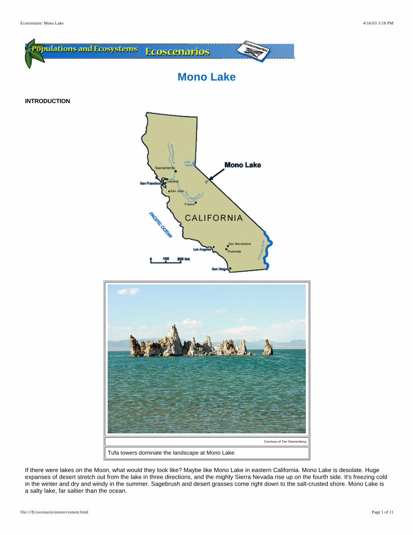
Mono Lake
INTRODUCTION
Courtesy of Teri Dannenberg
Tufa towers dominate the landscape at Mono Lake.
If there were lakes on the Moon, what would they look like? Maybe like Mono Lake in eastern California. Mono Lake is desolate. Huge expanses of desert stretch out from the lake in three directions, and the mighty Sierra Nevada rise up on the fourth side. It's freezing cold in the winter and dry and windy in the summer. Sagebrush and desert grasses come right down to the salt-crusted shore. Mono Lake is a salty lake, far saltier than the ocean.
4/16/03 3:18 PMEcoscenario: Mono Lake
Page 1 of 11file:///Ecoscenario/mono/content.html

Mono Lake is a unique and ancient ecosystem. It is at least 760,000 years old, making it the oldest lake in the United States. The lake is a tiny leftover puddle from a huge lake that covered a bit of California and a large part of Nevada and Utah hundreds of thousands of years ago. When ancient Lake Lahontan receded, only Great Salt Lake, Mono Lake, and a handful of other small basins retained water. The minerals from the lake water concentrated in the small lakes, resulting in the high salt concentrations. , such as Mono Lake, are found throughout the world.
Alkaline lakes
The origin of the name Mono, pronounced MOH•noh, is unclear, but may have been a Yokut word for fly eater. The first humans to live here were the Kutzadika'a, a small group of Native Americans. Their name roughly translates to fly eaters because of the , or
pupae they harvested and ate. The word is not in their vocabulary.kutsavi
alkali fly Mono
Art Explosion
The rising Sun casts an eerie light on tufa towers and lake surface.
The first Europeans arrived in the Mono Lake basin in 1852. A few years later, gold was discovered in the hills north of Mono, and the boom towns of Aurora, Bodie, and Lundy sprang up. A rush to build consumed the nearby piñon pine forests and deprived the Kutzadika'a protection and sufficient hunting to sustain the tribe. Most members moved from the Mono Lake basin, and only a few remain in the area today. By 1863, the population of Aurora reached over 5000. Most residents were miners, but a few had other reasons for being there. One notable resident was Samuel Clemens, better known by his penname of Mark Twain. He spent six months trying his luck as a miner before going bust. Stories of his adventures in Aurora appear in his novel, . Roughing It
Courtesy of Teri Dannenberg Courtesy of Teri Dannenberg
The ghost town of Bodie lies in the hills north of Mono Lake.
Once a booming gold rush town, Bodie has been preserved, but not restored, as a California State Historical Park.
The gold boom lasted only a few years, and by 1877 the population of Mono County was less than 1000. Mining continued in the area until the 1930s and the Depression. Today, only ghost towns remain of the once prosperous mining towns and ranches. Many ranchers sold their land and water rights to the Los Angeles Department of Water and Power and moved. The city of Los Angeles is the largest landowner in the area.
4/16/03 3:18 PMEcoscenario: Mono Lake
Page 2 of 11file:///Ecoscenario/mono/content.html

In 1941 Los Angeles began diverting water from the freshwater streams that feed Mono Lake. Aquaducts carried the water 563 kilometers (352 miles) to a rapidly growing city. Changes to the lake were dramatic. Without a freshwater source the salinity of the lake doubled. By 1995 the water level had dropped over 13.7 meters (45 feet).
Even though it looks barren and deserted at first glance, Mono Lake is actually one of the most productive ecosystems on the continent. Below the water's surface a huge population of algae is the base of a food chain. Massive populations of and feed on the algae. These crustaceans and insects in turn provide nourishment for populations of birds that come to Mono Lake from as far away as the Arctic Circle and the equator. Millions of birds visit Mono Basin between midsummer and fall, feasting on the abundant food and nesting on the protected islands.
brine shrimp brine flies
ABIOTIC DATA
Mono Lake, the largest lake completely in California, covering 183 square kilometers (70.5 square miles), sits in a broad, shallow basin with no outlet. Water flows into the lake from several small freshwater streams, but no water ever flows out. Fresh water picks up minute amounts of salt in its journey to the basin, and the only way out for the water is through evaporation. Consequently, over the years salt has built up in the lake. Mono Lake basin is an active volcanic area. The two islands, Negit and Paoha, are actually small volcanic cinder cones sticking out of the lake. Paoha, larger of the two cinder cones, still spouts steam from vents, and there are several hot springs on the island as well.
Courtesty of Teri Dannenberg Courtesy of the Mono Lake Committee
Negit Island is the exposed top of a volcanic cinder cone.
David Gaines demonstrates that floating in the superalkaline water is almost effortless.
Salt
The most important abiotic factor in Mono Lake is high salt content. In fact, Mono Lake contains about 280 million tons of dissolved salts. These salts are composed of many different salts, one of which is sodium chloride or table salt. This makes the water alkaline. Alkaline water is basic (as opposed to acidic). The alkali salts raise the pH to about 10, and the water feels slippery between your fingers. If you wanted to make your own Mono Lake water at home, you would stir up this recipe.
37 ml sodium chloride (table salt)67 ml sodium bicarbonate (baking soda)10 ml magnesium sulfate (Epsom salt)a pinch of sodium borate (borax)a pinch of phosphate (detergent)1 liter water
Light and temperature
Mono Lake is wedged between the Great Basin (a high desert) and the Sierra Nevada at an elevation of about 2000 meters (6560 feet). At this elevation winter temperatures are cold, rarely going over 5°C (41°F) during the day and plunging to –8°C (18°F) at night. Days are short during the winter, with only 9 hours of light on December 21, the winter solstice.
During the summer, temperatures are generally pleasant, averaging 28°C (82°F) for highs and falling to 9°C (48°F) at night. The longest summer days are 15 hours long.
4/16/03 3:18 PMEcoscenario: Mono Lake
Page 3 of 11file:///Ecoscenario/mono/content.html

During the summer a layer of warm water forms on top of the lake. When fall weather sets in, that top layer is chilled. As it cools, the water contracts and gets denser. In the fall the surface water gets dense enough to plunge to the bottom of the lake. This is a phenomenon known as turnover. The force of the turnover brings nutrients to the surface, starting an algal bloom that establishes the base of the food web in the Mono Lake ecosystem.
Precipitation and water
Rain and snow are critically important to the stability of Mono Lake. Typical total annual precipitation is around 35 centimeters (14 inches). That isn't a lot. Fresh water coming into the lake is essential to offset the water lost to evaporation.
If less water comes into the lake than is lost to evaporation, the lake will shrink, but the amount of salt will not. As a result, the lake water will get saltier. This is exactly what happened between 1941 and 1981. Water was diverted out of streams that delivered fresh water to Mono Lake, and the lake declined steadily for 40 years. By 1981, the volume of the lake was down by half, and the salt concentration had doubled. The water level in the lake had dropped 13.7 meters (45 feet), exposing hundreds of tufa towers that had been hidden below the lake's surface.
4/16/03 3:18 PMEcoscenario: Mono Lake
Page 4 of 11file:///Ecoscenario/mono/content.html

Courtesy of Mono Lake Committee
Water level fluctuations since 1850
Tufa Towers
Some of the most dramatic features of Mono Lake are the tufa (TOO•fah) towers. These strangely shaped spires rise from the water near the shoreline. Tufa towers form underwater over springs. When the carbonate-rich spring water comes in contact with the sodium bicarbonate (baking soda) in the water, the carbonate precipitates and forms limestone. The limestone builds up over the spring, and after centuries a tufa tower forms. Some are as tall as 9 meters (30 feet).
Tufa towers became visible above the water when the water level began dropping in 1941. Once exposed, the towers are subjected to weather, resulting in rapid erosion.
Courtesy of Teri Dannenberg Courtesy of Teri Dannenberg
Tufa towers formed underwater for centuries until a drop in the water level exposed them.
Some tufa towers are completely exposed on dry land. Lost in vegetation, they are subjected to weathering and erosion.
Islands
The two islands in Mono Lake, Negit and Paoha, provide critical shelter for many of the lake's nesting birds, particularly the. Isolation on the islands provides protection from predatory animals, such as .
Californiagull coyotes
4/16/03 3:18 PMEcoscenario: Mono Lake
Page 5 of 11file:///Ecoscenario/mono/content.html

Courtesy of Teri Dannenberg
Negit (left) and Paoha (right) islands provide protected nesting grounds for migrating birds.
BIOTIC DATA
Even though it has none of the organisms you might expect to find in a lake, like fish and frogs, Mono Lake is filled with life. It is one of the most productive ecosystems in North America. The base of the food web is microscopic . During the winter and early spring, after the lake has turned over, bringing nutrients to the surface layer of water, algae reproduce very quickly. By March the lake is "as green as pea soup" with photosynthesizing algae.
planktonic algae
Art Explosion Art Explosion
Blooms of planktonic and benthic algae give the water a green cast.
Migrating birds stop at Mono Lake to eat brine shrimp and brine flies that feed on the algae.
At this time countless hatch out of their hard-shelled cysts on the bottom of the lake. Microscopic themselves at first, they brine shrimp
4/16/03 3:18 PMEcoscenario: Mono Lake
Page 6 of 11file:///Ecoscenario/mono/content.html

feed eagerly on the algae, and after a few weeks they mature and produce a huge second generation of brine shrimp. In June and July, 4 or 5 trillion mature brine shrimp, each about 1 centimeter (0.4 inches) long, fill the lake.
At the same time, the larvae of the (also known as alkali flies) that have been inactive on the lake bottom wake up and start eating the that grow on the lake bottom. By midsummer, millions of brine flies are skittering across the surface of the lake.
brine fliesbenthic algae
Courtesy of Teri Dannenberg Courtesy of Teri Dannenberg
California gulls feeding on brine flies at the shoreline. The darker area at the water's edge is adult brine flies.
Brine fly larvae and adults cover the lake bottom and the shoreline.
The bounty of shrimp and flies is eaten by huge numbers of birds. Nesting birds include 50,000 (85% of California's breeding population and second largest colony in the world) and 400 (11% of the state's breeding population). Migratory birds include 1–2 million (30% of the North American population), 80,000 (10% of the world population), 60,000 (3% of the world population), and smaller numbers of 79 other species of water birds.
California gullssnowy plovers
eared grebes Wilson's phalaropesred-necked phalaropes
Courtesy of Mono Lake Committee Courtesy of Mono Lake Committee
A pair of mating brine shrimpMillions of birds feed on the trillions of brine shrimp in Mono Lake.
Mono Lake is a critically important feeding stop for birds migrating south from Canada. The phalaropes and grebes arrive at the lake completely depleted of energy reserves. They linger there for several weeks, gorging on shrimp and flies until they have doubled their body weight with high-energy fats. Refueled and refreshed, they can complete their migration to Central and South America.
With the departure of the last migrating birds, Mono Lake is briefly quiet. The surface is devoid of life—no flies, no birds. The lake water is clear and still. The ate all the , and in turn were eaten by the migratory birds. The brine shrimp egg cysts lie waiting on the lake bottom with the dormant larvae of the . The chill of autumn closes in, and Mono Lake gets cold. Then the lake turns over for the 760 thousandth time, and the few remaining algae respond. The cycle repeats.
brine shrimp algaebrine flies
ISSUES
There is really only one issue at Mono Lake...fresh water. Life depends on it in Mono Lake as surely as it does in every other ecosystem
4/16/03 3:18 PMEcoscenario: Mono Lake
Page 7 of 11file:///Ecoscenario/mono/content.html

on Earth. Humans have a tremendous thirst for water, and whenever they see an opportunity to gather some up and apply it to human use and enterprise, they usually do.
The Los Angeles Department of Water and Power looked at the streams running out of the Sierra Nevada into what seemed to be a salty, useless lake, and contracted to build a system of diversion dams to ship the water south for Angelinos. The project was completed in 1941, and virtually all the water destined for Mono Lake was piped to southern California. Without the annual inflow of fresh water, the lake began to dry up. The lake level, standing at 1956.5 meters (6417 feet) in 1941, began a steady decline. The water level dropped 30 centimeters (1 foot) or so each year. Twenty years later the lake stood at 1950 meters (6396 feet), a drop of 6.5 meters (21 feet) since the onset of diversion.
Courtesy of Mono Lake Committee Courtesy of Mono Lake Committee Courtesy of Mono Lake Committee
Photo taken in 1962 when the water level was already 7.5 meters (25 feet) below the original level.
The same tufa towers in a photo taken in 1968.
The tufa towers are completely exposed in this photo taken in 1995.
By the mid-1970s the lake level was down 12 meters (40 feet). The lake held half the amount of water it had before diversions started. The effects were starting to show in the ecosystem. The salt was twice as concentrated, and this stressed the populations of primary consumers, the and . The shrimp were not growing as large as usual, and their numbers were declining. This became clear in 1981 when the brine shrimp production was so reduced that the 50,000 breeding were not able to catch enough shrimp to feed their offspring, and 25,000 half-grown chicks starved to death. A generation of California gulls was lost. Furthermore, the water was so low at this time that a land bridge developed, connecting Negit Island to the mainland. This allowed predators like to walk to the nesting area, where they ate the gull eggs and chicks and drove the adults away.
brine flies brine shrimpCalifornia gulls
coyotes
In addition to the changes to the lake populations, the lower water level caused other problems. As water evaporated, the lake shrank exposing a layer of alkaline salts. High winds stir up these salts and create toxic dust storms. These dust storms are a health hazard for everyone living in the Mono Lake basin.
Courtesy of Teri Dannenberg Courtesy of Teri Dannenberg
A rim of salts appeared as the water level dropped. High winds stir up an alkaline dust storm that decreases visibility.
In 1978 a young man named David Gaines recognized the plight of Mono Lake and founded an action group called the Mono Lake Committee. He started to work on ways to reverse the damage done by the water diversions. He worked tirelessly with the National Audubon Society, California Trout, the California Department of Fish and Game, the U.S. Forest Service, and the Los Angeles Department of Water and Power (LADWP) to find solutions to the problem. Often the issues ended up in court.
In 1984 the first of several lawsuits was decided in favor of Mono Lake. The LADWP was ordered to release 0.57 cubic meters (19 cubic feet) of water per second into the lake. In 1986 another suit resulted in the release of another 0.3 cubic meter (10 cubic feet) per second.
4/16/03 3:18 PMEcoscenario: Mono Lake
Page 8 of 11file:///Ecoscenario/mono/content.html

The lake was now maintaining, but not regaining its level. (Note: 1 cubic foot per second is about 450 gallons of water per minute!)
David Gaines was killed in an automobile accident in 1988, but the work that he started continued. The California Supreme Court issued a landmark decision on September 28, 1994. It ruled that the LADWP had to renegotiate its license. It was required to release enough water to restore the lake to a level of 1948 meters (6391 feet), and enough water after that to stabilize Mono Lake at that level. This is expected to take 10–20 years. By October 1998, the water elevation was 1946 meters (6384 feet) and still rising. While 1948 meters (6391 feet) is below the pre-diversion level, it represents a compromise between the needs of natural systems and the needs of people.
Courtesy of Teri Dannenberg
Brush and shrubs that grew around exposed tufa towers die as the alkaline water inches back.
This water level should guarantee the vitality of the ecosystem, prevent a land bridge from reaching Negit Island, allow trout to spawn in the freshwater creeks feeding Mono Lake, and ensure excellent scenic views for Mono Lake visitors. On September 28, 1994, the day of the decision, Marc Del Piero of the State Water Resources Control Board proclaimed, "Let this be known as the day we saved Mono Lake."
Is Mono Lake saved? What demand will be placed on the precious fresh water flowing into the briny lake when California's human population, which is 35 million, reaches 50 million or more in a generation or two? Will we still have the will to protect the lake for the benefit of the shrimp, flies, and migratory birds? They do have a valid claim...they were here 760,000 years before us.
THE DEBATE
Before making decisions that affect an ecosystem, it is important to gather information from a variety of sources. Below are the views of several individuals or groups that have an interest in the future of Mono Lake. After each quote the hyperlink goes to the original source of the quote. Refer to these sites for more information.
Use the information provided to decide where you stand on this debate.
DEBATE: Should water be diverted from Mono Lake to southern California?
People who support water-diversion level outlined by the 1998 court decision
"Our conservation efforts and contol of the lands in the Mono Lake basin has made the area a desirable vacation spot."
"The Eastern Sierra is truly a recreation paradise, from the tall mountain peaks laced with lakes and streams to the valley floors. Visitors to, and residents of, this beautiful area will find much to enjoy. Most of the land is owned and administered by the United States Forest Service and the Bureau of Land Management."
Los Angeles Department of Water and Power official
Los Angeles Department of Water and Power, Recreational Uses of City of Los Angeles, Eastern Sierra Land
http://web.ladwp.com/~wsoweb/Aqueduct/recuses/recreationindex.htm
"In 1987 only 10,594 birds were counted in our annual fall shorebird count. In 2001 there were 40,606 and that doesn't even include the California gulls or eared grebes. There were over 28,000 red-necked phalaropes. Mono Lake is returning to its pre-diversion numbers of birds."
Birdwatcher
Mono Basin Clearinghouse, -Raw Data and Field Notes from Mono Lake http://www.monobasinresearch.org/data/index.html
People who support returning Mono Lake to its prediversion level
4/16/03 3:18 PMEcoscenario: Mono Lake
Page 9 of 11file:///Ecoscenario/mono/content.html

"Even though the water has risen, the habitat used by the waterfowl is still in danger."
"The Water Board decision recognizes that some of Mono Lake's pre-diversion qualities will not be restored at the 6392 level. A waterfowl habitat restoration plan is also required, to help mitigate lost shoreline qualities that once attracted close to a million ducks and geese."
Ornithologist studying birds at Mono Lake
David Carle, park ranger, Mono Lake Tufa State Reserve, The Mono Lake Water Issue: An Update as of October 1998
http://www.thesierraweb.com/sightseeing/monolake/update.html
"People in cities need to work more on conservation methods to use less water. Then they won't have to divert as much water from areas like Mono Lake."
"Solutions involve finding ways for the urban area to use less water. The most cost effective way to do this is to implement water conservation measures. Low-flow plumbing fixtures (showerheads, toilets, and faucets) are the most permanent method, although changing behavioral practices can be extremely effective. The City of Los Angeles reduced its water use by 30% during a drought in 1991 by requiring residents to conserve water, and it has maintained a 1970s level of water use despite a population increase of 1 million people."
Conservationist
Living Lakes, Water Diversion for Urban Use
http://www.livinglakes.org/issues/diversions.htm
"On Lee Vining Creek, several historic channels have been reopened and rewatered downstream from Highway 395, providing fish habitat and recharging the groundwater table so that riparian vegetation can become reestablished across portions of the former floodplain. Willow, cottonwood, and Jeffrey pine seedlings have been planted generally in areas too removed from the stream channels to be regenerated naturally. Livestock grazing was excluded from the riparian corridor to promote vegetative recovery. Mechanical work such as digging pools and laying gravel bars was tried when flows were lower, but now the emphasis of restoration is on mimicking natural flows."
Mono Lake Committee, Restoration
http://www.monolake.org/politicalhistory/restore.htm
Questions
Which side of this debate do you support?
What scientific evidence supports your position?
After looking at the evidence, did you change your position? Please explain why.
WEB LINKS
Mono Lake Committee - http://www.monolake.org/index.html
American University, Trade Environment Database, TED Case Studies, (MONO Case) -
The Los Angeles Aqueduct and the Owens and Mono Lakeshttp://www.american.edu/TED/MONO.HTM
Center for the Study of the Environment, - Mono Lake: A Lesson in Environmental Problem Solving http://www.naturestudy.org/projects/mono.htm
David Carle, park ranger, Mono Lake Tufa State Reserve, - The Mono Lake Water Issue: An Update as of October 1998 http://www.thesierraweb.com/sightseeing/monolake/update.html
Eastern Sierra Webpage, Lee Vining & Mono Lake - http://www.thesierraweb.com/sightseeing/monolake.html
Institute for Computational Earth System Science, Biogeographical Processes Group, Mono Lake map - http://www.icess.ucsb.edu/biogeo/mono1/mono.html
Living Lakes, Mono Lake - http://www.livinglakes.org/mono/
Living Lakes, - Water Diversion for Urban Use http://www.livinglakes.org/issues/diversions.htm
Los Angeles Department of Water and Power, - Mono Basin Watershed: Mono Lake Level Restoration http://web.ladwp.com/~wsoweb/Aqueduct/WatershedMgmtWeb/monobasin.htm
Los Angeles Department of Water and Power, -Recreational Uses of City of Los Angeles, Eastern Sierra Land http://web.ladwp.com/~wsoweb/Aqueduct/recuses/recreationindex.htm
Los Angeles Department of Water and Power, -Welcome to the Los Angeles Aqueduct http://web.ladwp.com/~wsoweb/Aqueduct/
Mono Basin Clearinghouse, - Mono Basin Reports and Studies Online http://www.monobasinresearch.org/onlinereports/index.html
4/16/03 3:18 PMEcoscenario: Mono Lake
Page 10 of 11file:///Ecoscenario/mono/content.html

Mono Basin Clearinghouse, -Raw Data and Field Notes from Mono Lake http://www.monobasinresearch.org/data/index.html
Mono Basin Clearinghouse, - Summary of Mono Lake Litigation and Legislation http://www.monobasinresearch.org/timelines/polchr.htm
Mono Lake Committee, Restoration - http://www.monolake.org/politicalhistory/restore.htm
Mono Lake Tufa State Reserve - http://www.parks.ca.gov/default.asp?page_id=514
Mono Lake, Water Resources Control Board Decision 1631 - http://www.appliedhydrogeology.com/Mono%20Lake%20-%20Water%20Resources%20Control%20Board%20Decision%201631.htm
Sierra Gateway Maps, Mono Lake map - http://www.sierragatewaymap.com/mono-map.html
4/16/03 3:18 PMEcoscenario: Mono Lake
Page 11 of 11file:///Ecoscenario/mono/content.html