Embed Size (px)
Citation preview
Report of the investigation into the grounding of M/V Mona Lisa
at the Irbe Strait, Latvia
on
04th May 2008
MONA LISA
THE BAHAMAS MARITIME AUTHORITY ii
The Bahamas Maritime Authority investigates incidents at sea for the sole purpose of discovering any lessons which may be learned with a view to preventing any repetition. It is not the purpose of the investigation to establish liability or to apportion blame, except in so far as emerges as part of the process of investigating that incident.
It should be noted that the Bahamas Merchant Shipping Act, Para 170 (2) requires officers of a ship involved in an accident to answer an Inspector’s questions fully and truly. If the contents of a report were subsequently submitted as evidence in court proceedings relating to an accident this could offend the principle that a person cannot be required to give evidence against him. The Bahamas Maritime Authority makes this report available to any interested parties on the strict understanding that it will not be used as evidence in any court proceedings anywhere in the world.
Date of Issue 15th January 2009
Bahamas Maritime Authority 120 Old Broad Street
LONDON EC2N 1AR
United Kingdom
MONA LISA
THE BAHAMAS MARITIME AUTHORITY iii
CONTENTS
1. Summary
2. Particulars of Vessel
3. Narrative of events
4. Analysis
5. Conclusions
6. Recommendations
List of Appendices:
I. Ships Particulars
II. Copy of actual BA Chart 2226 used.
III. Bridge Watch Schedules
IV. Entrance to the Gulf of Riga BA2226 – Passage Plan
V. Passage Plan
VI. Passage Plan overlaid with AIS Track
VII. AIS Track and Position of Mona Lisa
VIII. View of the Steering Position
IX. VDR Playback Data
X. VDR Alarm Log Sheet
MONA LISA
THE BAHAMAS MARITIME AUTHORITY iv
Abbreviations Used In This Report ARPA Automatic Radar Plotting Aid AIS Automatic Identification System BA British Admiralty ºC Degrees Celsius GPS Global Positioning System GT Gross Tonnage IMO I International Maritime Organisation ISM International Safety Management Kts Knots are Nautical Miles per hour ºT and ºG Degrees True and degrees Gyro LCD Liquid Crystal Display LT Local Time MAL Maritime Administration of Latvia m, m³, cm Metres, cubic metres, centimetres NM Nautical Miles (1nm=1852 metres) NTM Notice to Mariners MAL Marine Administration of Latvia OOW Officer of the Watch SAL Log Input ST Ships Time t Tonnes where (1t=1000kg) UTC Coordinated Universal Time VDR Voyage Data Recorder WGS84 World Geodetic System WO Wheel Over WP Waypoint
MONA LISA
THE BAHAMAS MARITIME AUTHORITY 1
1 SUMMARY
1.1 On 4th May 2008 at 0725 hours (UTC+3) passenger cruise vessel “MONA LISA” ran aground in the Irbe Strait about 10 miles off the north coast of Latvia in position: LAT 57° 45’ N; LONG 021° 43’ E.
1.2 The vessel was on voyage from Gdynia, Poland, to Riga, Latvia, with a total ship complement of 811 cruise passengers and 327 crew.
1.3 There was no pollution resulting from the grounding. No injuries were reported to passengers or crew.
1.4 Several attempts were made to pull the vessel free with the vessel’s 2 engines working astern and with the assistance of 4 tugs but the refloating attempts failed.
1.5 On 5th May all passengers and 23 crew were evacuated from the ship by Latvian naval vessels and safely taken to Ventspils, from where they were later taken by train to Riga for repatriation.
1.6 Refloating attempts continued during 5th – 6th May but without success.
1.7 The vessel was eventually refloated with the help of 4 tugs on 7th May at 1512 hours and she proceeded to Ventspils, escorted by a tug, for a dive survey and class inspection.
1.8 On 7th May at 1955 hours the vessel arrived at berth No. 37, Port of Ventspils.
1.9 An underwater inspection was carried out at Ventspils and noted that both propellers were “found to have small cracks 5 – 10 cm. A Condition of Class was imposed
1.10 The vessel was given permission by the classification society LR for a single voyage to Kiel. The vessel sailed Ventspils on 8th May 2008.
1.11 The cause of the grounding was a navigational error on the part of the officer of the watch who had deviated from the passage plan and passed the ship on the wrong side of Irbe Lighthouse.
MONA LISA
THE BAHAMAS MARITIME AUTHORITY 2
2 PARTICULARS OF VESSEL
2.1 Vessels Particulars
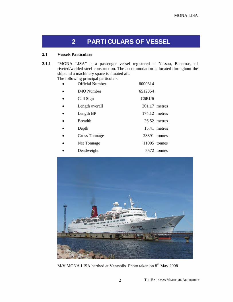
2.1.1 “MONA LISA” is a passenger vessel registered at Nassau, Bahamas, of riveted/welded steel construction. The accommodation is located throughout the ship and a machinery space is situated aft. The following principal particulars:
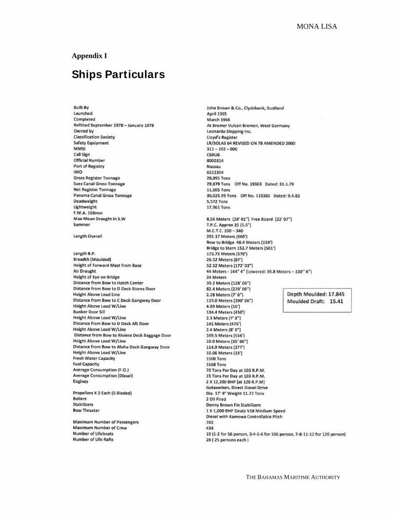
• Official Number 8000314
• IMO Number 6512354
• Call Sign C6RU6
• Length overall 201.17 metres
• Length BP 174.12 metres
• Breadth 26.52 metres
• Depth 15.41 metres
• Gross Tonnage 28891 tonnes
• Net Tonnage 11005 tonnes
• Deadweight 5572 tonnes
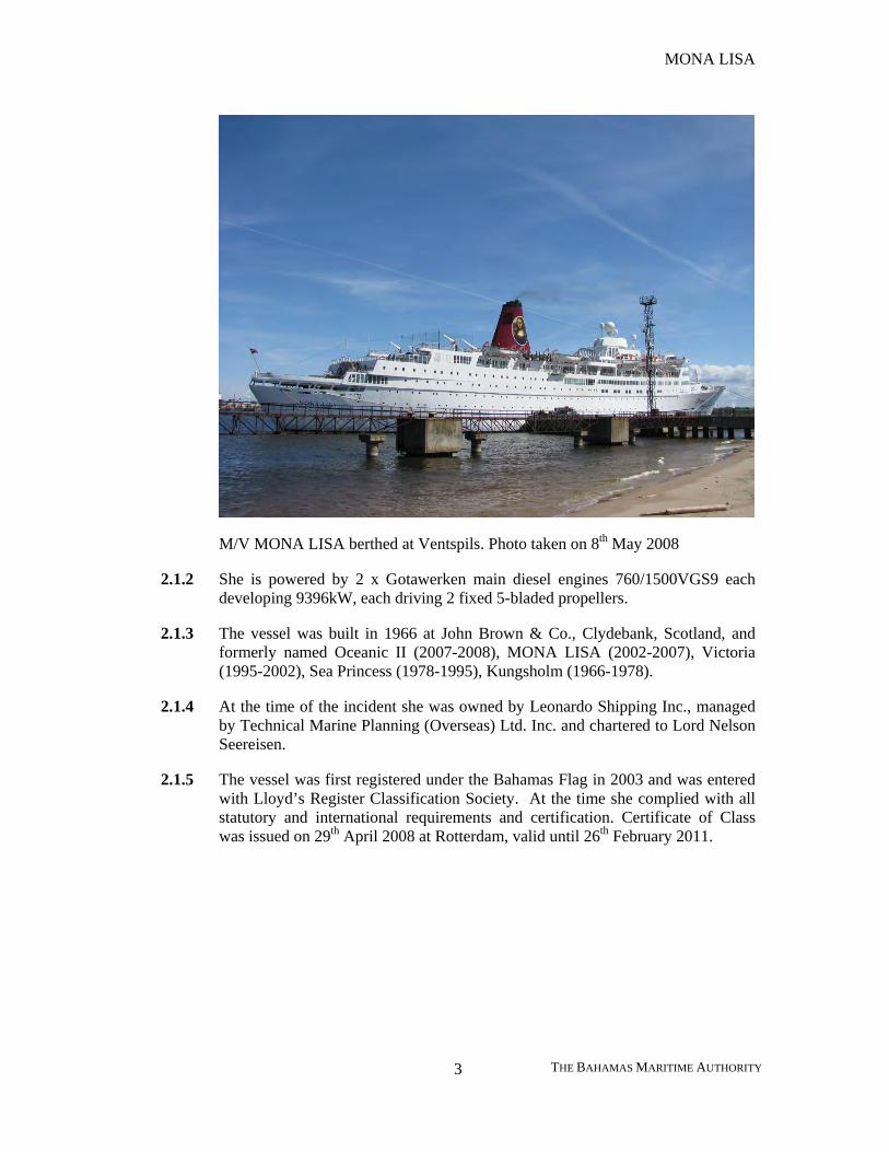
M/V MONA LISA berthed at Ventspils. Photo taken on 8th May 2008
MONA LISA
THE BAHAMAS MARITIME AUTHORITY 3
M/V MONA LISA berthed at Ventspils. Photo taken on 8th May 2008
2.1.2 She is powered by 2 x Gotawerken main diesel engines 760/1500VGS9 each developing 9396kW, each driving 2 fixed 5-bladed propellers.
2.1.3 The vessel was built in 1966 at John Brown & Co., Clydebank, Scotland, and formerly named Oceanic II (2007-2008), MONA LISA (2002-2007), Victoria (1995-2002), Sea Princess (1978-1995), Kungsholm (1966-1978).
2.1.4 At the time of the incident she was owned by Leonardo Shipping Inc., managed by Technical Marine Planning (Overseas) Ltd. Inc. and chartered to Lord Nelson Seereisen.
2.1.5 The vessel was first registered under the Bahamas Flag in 2003 and was entered with Lloyd’s Register Classification Society. At the time she complied with all statutory and international requirements and certification. Certificate of Class was issued on 29th April 2008 at Rotterdam, valid until 26th February 2011.
MONA LISA
THE BAHAMAS MARITIME AUTHORITY 4
2.2 Dry Dock and Inspections
2.2.1 The vessel dry docked at Rotterdam for refurbishment. Previously “MONA LISA” had been working as an educational vessel under Scholar Ship international educational program and in the dry dock the classrooms were refurbished into cabins. The vessel had left dry dock at Rotterdam on 29th April 2008 and the first Baltic Sea cruise commenced on 1st May 2008 departing from Kiel, Germany.
2.2.2 “MONA LISA” was last subjected to a Bahamas Maritime Authority Annual Inspection on the way from Rotterdam to Kiel on 1st May 2008. Following the Inspection 3 observations were observed which were subsequently rectified.
2.2.3 A Port State Inspection was carried out at Ventspils once the vessel had been re-floated on 7th May 2008. Following the more detailed inspection a total of 16 deficiencies were observed, the majority were rectified as required (Code 17) prior to the departure of the vessel from Ventspils.
2.3 Technical Marine Planning – Vessel Managers
2.3.1 The “MONA LISA” is managed by Technical Marine Planning (No: 1048137) who are based in Piraeus, Greece. The “MONA LISA” is the only vessel currently managed by them, although they have previously owned other similar vessels.
2.4 Bridge Layout
2.4.1 The Bridge is positioned at about a third of the length from forward; it is fitted with 3 Radars which were all operational at the time of the incident. There are 3 Pelorus rings on gyro repeaters on the bridge. One on each bridge wing and a third at the front of the Bridge on the ships centre line.
MONA LISA
THE BAHAMAS MARITIME AUTHORITY 5
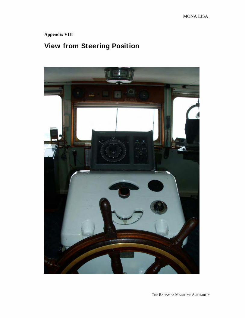
2.4.2 The manual steering position utilising a traditional wheel via a telemotor is located on the centre line in the middle of the Bridge.
2.4.3 All navigational equipment on the bridge was found to be in full working order.
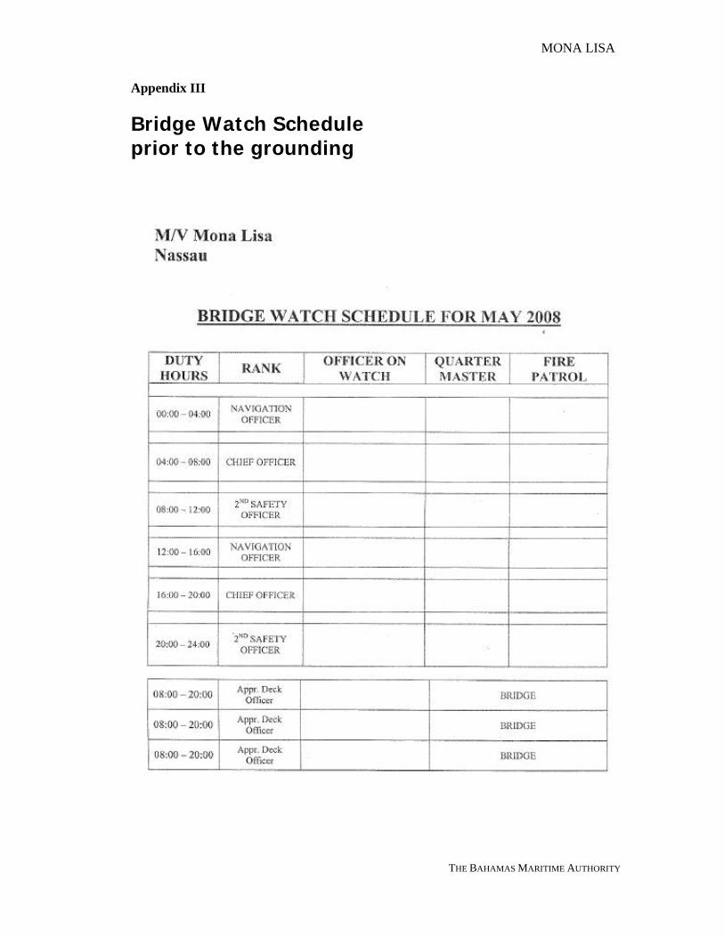
2.5 Bridge Team
2.5.1 A Review of the Safe Manning Document (SMD) was carried out and identified that all ships crew appropriately certified in line with the SMD issued on the 25th April 2007. All relevant Bahamas Endorsements were sighted.
2.5.2 The bridge team on board the “MONA LISA” at the time of the grounding consisted of Officer of the Watch and a Quartermaster. Although three Apprentice Deck Officer were on board and were allocated to each watch, they were only called upon as required; none were on the Bridge at the time of the incident. An additional crew member was used exclusively for a Fire Patrol throughout the ship and did not form part of the Bridge Team.
2.5.3 The Night Orders issued by the Master required: • Maintain Speed and Course according to the Voyage Plan. • Every Officer must check waypoints on his duty and make a compass
error whenever permitted. • Keep safe distance – 2NM of any vessel in the vicinity of the Open Sea. • Position taking by GPS will be verified.
2.5.4 The Chief Officer on watch at the time of the grounding was in possession of a
valid Unlimited Masters licence and a Bahamas Endorsement No: 0056203 issued in 25th April 2008. He held the position of Chief Officer for 3 years serving on RoRo vessels and Passenger ships.
2.5.5 The Chief Officer was allocated to the 4 – 8 watches. 2.5.6 The Chief Officer was on the 1600 – 2000 hours watch the previous day and
having been relieved by the 2nd Safety Officer at 2000 hours, took a meal and a few drinks of whisky before going to bed at 2230 hours. He was woken the next morning at 0340 hours. During the previous 24 hours he had been fully rested.
2.5.7 The Quartermaster on the bridge had a valid Navigational Watchkeeping
Certificate issued in April 2004. 2.5.8 The Quartermaster was also relieved at 2000 hours and following dinner retired
to bed at about 2200 hours. During the previous 24 hours period he had been fully rested.
MONA LISA
THE BAHAMAS MARITIME AUTHORITY 6
3 NARRATIVE OF EVENTS
3.1 General and Weather
3.1.1 All times noted in this narrative are given in the style of the standard 24 hour clock without additional annotation and as local time in the area, which was Eastern Europe Summer Time, EEST = UTC+3 (ship’s clocks were set to EEST on 4th May 2008 at 0001 hours). Other timing is noted in brackets.
3.1.2 The weather at the time of the incident was partly cloudy, with slight sea and good visibility. Wind WNW force 3 Beaufort; barometer reading 1014 millibars; sea water temperature +8°C
3.1.3 On board were 811 passengers and 327 crew at the time of the incident. The majority of the passengers being German. The crew consisted of 20 different nationalities with all the Senior Officers being Greek.
3.1.4 The draught on departure from Gdynia was 8.40 m forward and 8.50 m aft.
3.2 Voyage of the “MONA LISA”
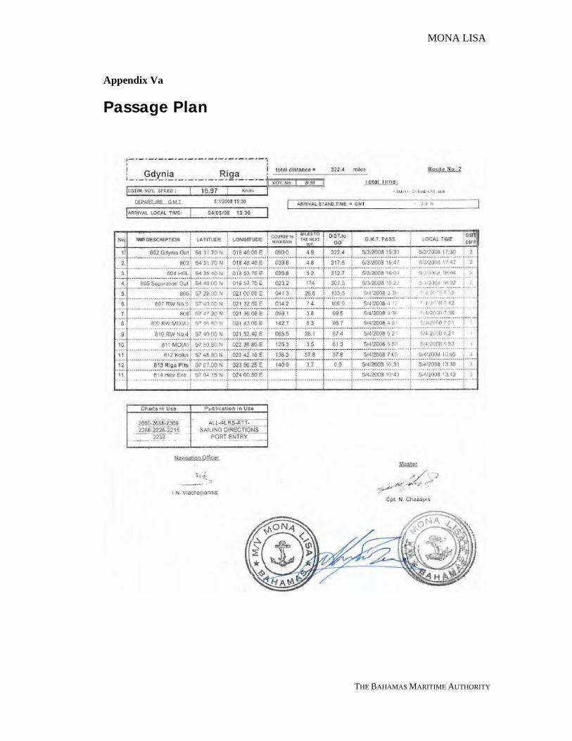
3.2.1 The proposed Passage Plan was drawn up by the Navigation Officer and was agreed and signed off by the Master. The distance from Gdynia to Riga was 322 nautical miles. The total steaming time was estimated at 20 hours with an ETA Riga Pilots was given as 4th May at 1330 hours.
3.2.2 The vessel had sailed from Gdynia, Poland, on Saturday, 3rd May 2008, bound for Riga, Latvia. The voyage having commenced at 1730 hours (UTC+2). The Gdynia Pilot disembarked and both engines were ordered full ahead at 1741 hours (UTC+2). Full Away of Passage was at 1748 hours (UTC+2) in position LAT 54° 31.7N LONG 18° 40E
3.2.3 The operation of the vessel’s main engines was limited due to critical revolutions between 93 rpm (17.58 knots) to 97 rpm (18.33 knots). During the voyage the engines were run at 98 rpm and the vessel was making an average speed of about 18.50 knots.
3.2.4 A normal seagoing watch on bridge consisted of the officer on watch and Quartermaster as per the Bridge Watch schedule. The Master was experienced in navigating in the Baltic and there was no sea pilot on board.
3.2.5 Ships Clock was advanced by 1 hours to UTC+3 (Eastern Europe Summer Time) at 0001 hours ships times on Sunday 4th May 2008.
MONA LISA
THE BAHAMAS MARITIME AUTHORITY 7
3.3 The Sea Passage
3.3.1 The passage from Gdynia to the Irbe Strait southern channel was uneventful, the weather reported as Cloudy, Slight Seas and Good Visibility.
3.3.2 The vessel passed closed to the Western Channel RW No. 5 buoy at 0638, at which time the distance to go was 106.9 nautical miles. The indication was that the vessel was on schedule for her reported arrival at Riga.
3.4 The Irbe Lighthouse and Irbe Strait
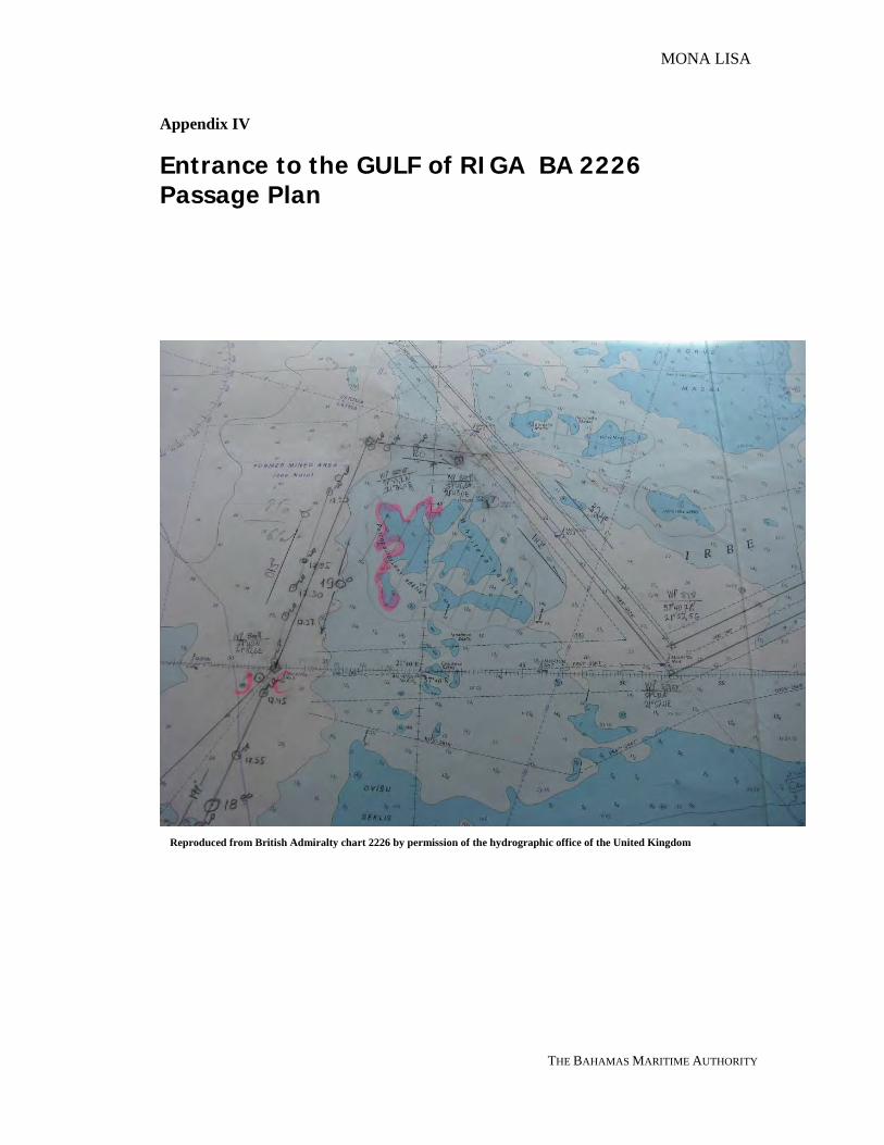
3.4.1 The Irbe Strait is the main entrance to the Gulf of Riga, partially obstructed by numerous shoal patches through which three fairways exist – Main Fairway, West Fairway and Inshore Fairway. The Main Fairway having a depth in excess of 10 metres.
3.4.2 The passage plan directed the “MONA LISA” into the Main Fairway, the intended track being to the east of the Irbe Lighthouse. This lighthouse protects shipping from the eastern side of the Mihailova Shoal, having a least depth of 5 metres over it.
3.4.3 The Irbe Lighthouse (LAT 57°45.04N LONG 21°43.38E) having an overall height of 35 metres and being a round black and white concrete tower with red bands and a helicopter platform was easily visible in the prevailing conditions at the time of the grounding.
Irbe Lighthouse and Location
MONA LISA
THE BAHAMAS MARITIME AUTHORITY 8
3.5 Approaching Irbe Strait
3.5.1 The voyage in the Baltic Sea was uneventful with fine weather, the schedule was being maintained. The vessel had followed the planned track and maintained course
3.5.2 According to the Quartermaster the helm was transferred from automatic to manual helm at 0600 hours. The initial instruction was to steer 043°, then to 040° and finally on a course of 020°.
3.5.3 According to the Log Book at 0638 hours in position LAT 57°40 N and LONG 021°32.6 E, to the west of No.5 Buoy at the entrance to the Irbe Strait southern channel, the vessel altered course to 014° (T) towards the northern entrance to the Main Irbe Channel. The track kept the vessel in deep water in excess of 20 metres. The Quartermaster confirmed a course of 015° (T) was ordered by the Chief Officer about this time.
3.5.4 The AIS tracking printout forwarded from the Maritime Administration of Latvia (MAL), a vessel “NOSSAN” passed ahead of the “MONA LISA” heading out on a course of 292° (T) speed 10.7 knots at about 0700 hours.
3.5.5 The Bridge Log Book at 0702 hours shows her position as being LAT 57°47.2 N and LONG 021°36.0 E the vessel altered course 100° (T). This course alteration would lead to the leading lights 142.8º-322.8º at 1½ miles north of Irbe Lighthouse. This was the last observed position.
3.5.6 However having interpolated the AIS data, submitted by the MAL for 0702 hours, the estimated position was 57°47N 21°37.4E, 0.9 NM closer to the Irbe Lighthouse.
3.5.7 According to the statement from the Quartermaster, an alteration of course to 150° was ordered by the Chief Officer, a review of the AIS data indicated that the alteration was made at about 0709 hours. In his statement, the Chief Officer said he had intended to alter course to 130°, but instead ordered a course alteration to 150°.
MONA LISA
THE BAHAMAS MARITIME AUTHORITY 9
3.5.8 Prior to the grounding the Quartermaster brought to the attention of the OOW his concern as to the position of the lighthouse. The Chief Officer acknowledged his comments, but didn’t appear to appreciate the imminent danger of the vessel and didn’t take any action.
3.6 Grounding off Irbe Lighthouse, Gulf of Riga
3.6.1 On 04th May at 0725 hours the vessel ran aground in position LAT 57°45.0 N and LONG 021°43.0 E; at the distance of 0.24 miles, bearing 061° to Irbe Lighthouse, at the charted depth of 5 m
3.6.2 The main engines were stopped. All watertight doors were shut manually and tank sounding began by crew. The hull was found to be sound and watertight.
3.6.3 At 0735 hours Riga Rescue Centre was contacted via VHF. At 0750 hours an announcement was made by the Cruise Director via the vessel’s PA-system and the passengers were put on notice of the situation.
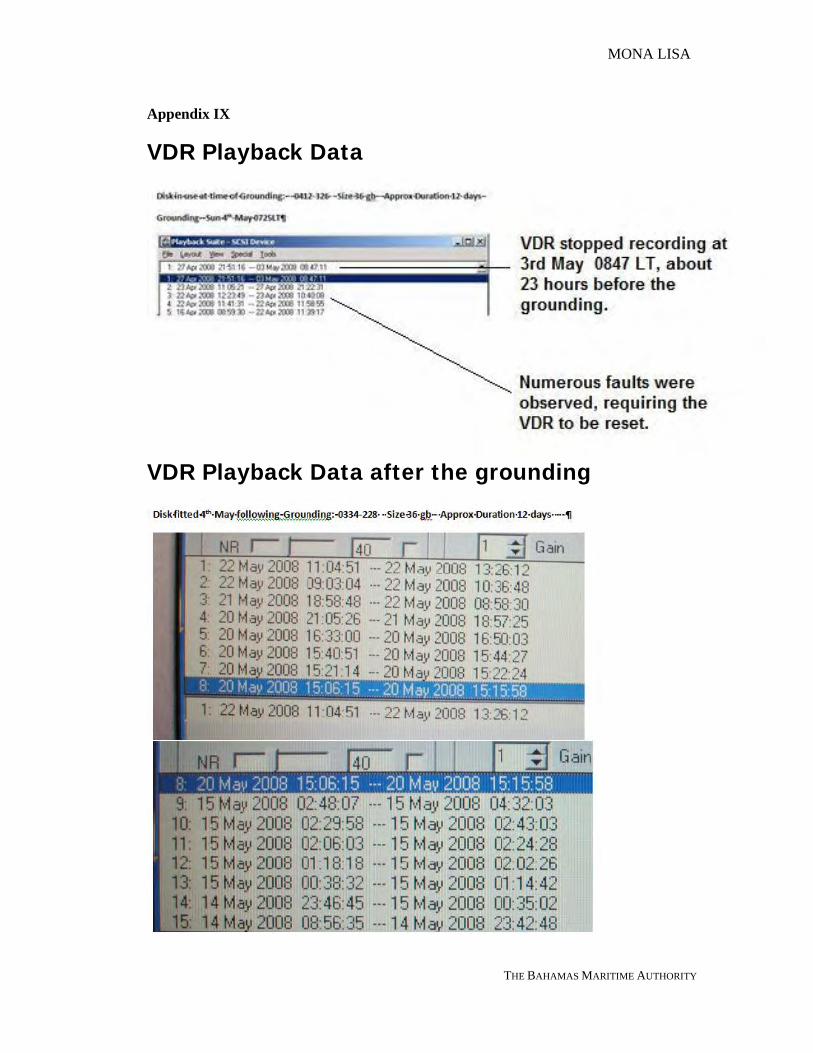
3.6.4 The VDR data was preserved following the grounding, although it was subsequently found no data was present on the Hard Disk for the 23 hours prior to the grounding. The Hard Disk serial no: 0412-326, having a capacity of 36gb with a total recordable duration of approximately 12 days.
3.6.5 Drug and Alcohol test performed on the Chief Officer on watch following the grounding by the ships Doctor was negative.
position of grounding
Estonia
Latvia
Gulf of Riga
MONA LISA
THE BAHAMAS MARITIME AUTHORITY 10
3.6.6 At 0920 hours Riga Rescue Centre was contacted again and 3 tugs requested for assistance.
3.6.7 At 1005 hours coastguard vessel KA-06 GAISMA arrived on scene and inspected the surrounding area for possible oil spills.
3.7 Re-floating of the “MONA LISA”
3.7.1 Later during the day coastguard personnel boarded the vessel by helicopter. Divers arrived with a coastguard vessel KA-01 and carried out underwater inspection. It was mutually decided to pull the vessel free with the assistance of 3 tugs.
3.7.2 The first re-floating attempt started on 04th May at 1945 hours with 1 tug made fast forward and 2 tugs made fast aft. The aft tugs were pulling and the vessel’s main engines were working on half astern. The attempt had no effect and at 2115 hours the engines were stopped.
3.7.3 Another tug arrived on scene at 2330 hours. The second attempt to pull the vessel free was made on 05th May at 0020 hours with the help of 4 tugs and both engines working on full astern. Various attempts were undertaken through the night until 1031 hours but without success. It was then decided to take the passengers off the vessel. Riga Rescue was contacted again and evacuation possibilities discussed.
3.7.4 On 05th May at 1140 hours 2 Latvian Navy vessels arrived alongside. These were the A-53 on the starboard side and the A-90 on the port side. Evacuation of passengers started from both sides of the vessel. The A-90 took off 167 passengers and 7 crew members; the A-53 took off 644 passengers and 16 crew members. The evacuated people were later landed at Ventspils.
3.7.5 On 06th May at 1305 hours a third attempt was undertaken to refloat the vessel with the help of 2 tugs. The attempt failed.
3.7.6 At 1450 hours the refloating attempts resumed with the help of 3 tugs and the vessel’s main engines run at various speeds ahead and astern. At 2015 hours the operations ceased with no result.
3.7.7 On 07th May at 0500 hours a more powerful tug SVITZER NJORD arrived from Denmark. At 0611 hours refloating operations resumed with 4 tugs assisting: the SVITZER NJORD, the AMBER, the MARSS-1 and the FLOROV. The vessel’s main engines were working on full astern.
3.7.8 At 1512 hours the vessel was refloated. At 1603 hours the vessel anchored in the vicinity for inspection. At 1640 hours orders were received from LR to proceed to Ventspils for further inspection and at 1652 hours the anchor was up and the vessel proceeded to Ventspils with a tug escort.
MONA LISA
THE BAHAMAS MARITIME AUTHORITY 11
3.8 Port of Refuge - Ventspils
3.8.1 On 07th May at 1955 hours the vessel arrived safely at Ventspils. Port authorities boarded the vessel on arrival.
3.8.2 During subsequent underwater inspection in the morning of 08th May the bottom plating was noted with scattered longitudinal scratches, mainly aft of amidships, starting from extreme forward and extending to the skeg, the sternward extension of the keel. No significant indents were reported. Both propellers were noted to have sustained damage to blade edges in the form of cracks up to 5-10 mm depth. Propeller blades were required to be equally cropped so as to avoid likely vibration and appropriate condition of class was imposed with due date on 12th May 2008.
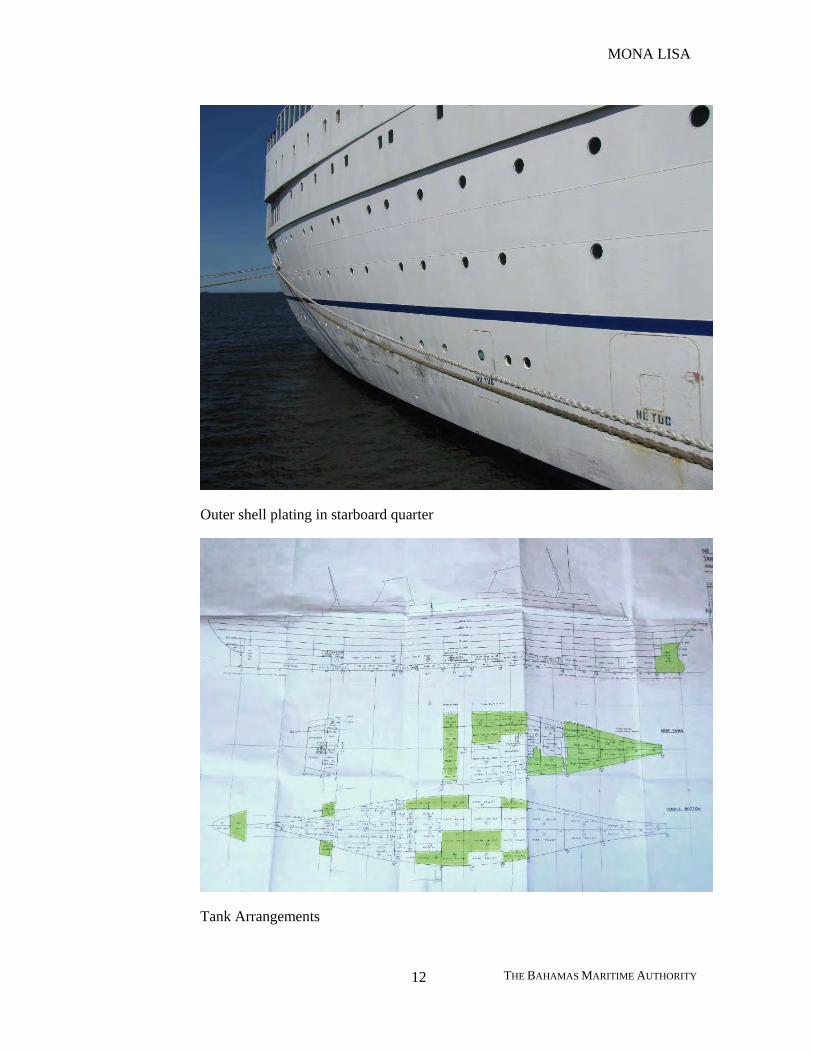
3.8.3 It was noted the shell plating locally rubbed and set in above waterline in the starboard quarter probably due to the tugs pushing during refloating operations.
Bow of the vessel
MONA LISA
THE BAHAMAS MARITIME AUTHORITY 12
Outer shell plating in starboard quarter
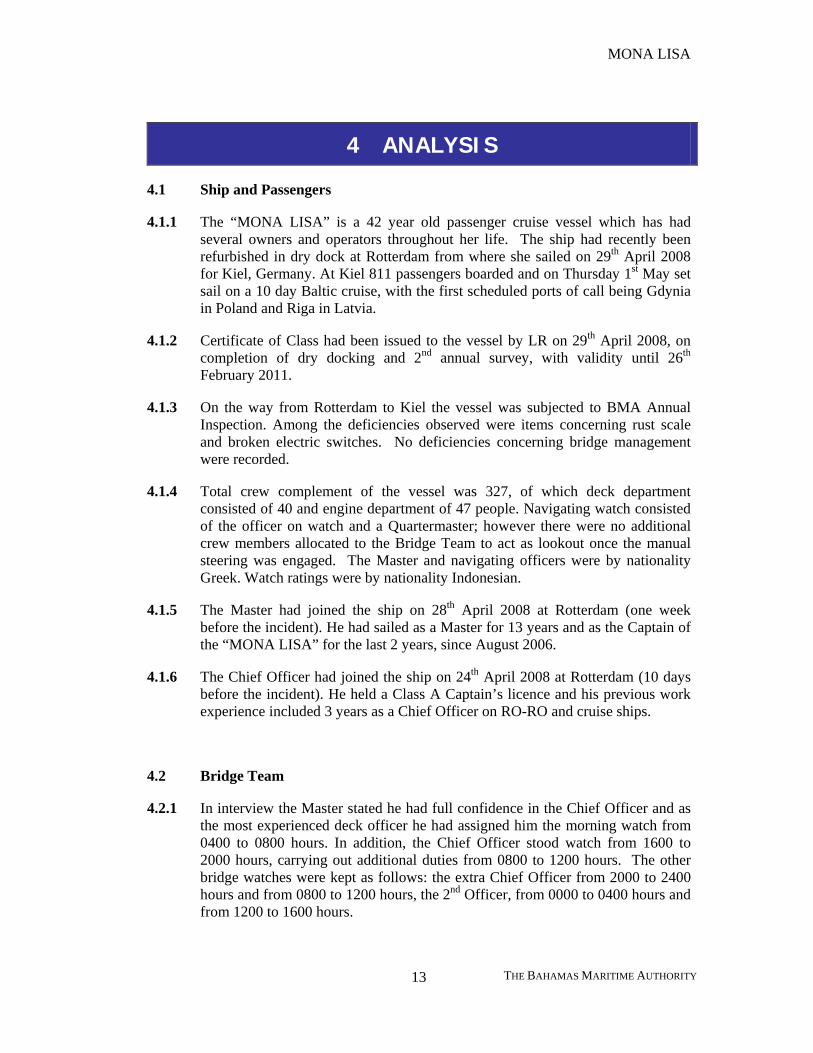
Tank Arrangements
MONA LISA
THE BAHAMAS MARITIME AUTHORITY 13
4 ANALYSIS
4.1 Ship and Passengers
4.1.1 The “MONA LISA” is a 42 year old passenger cruise vessel which has had several owners and operators throughout her life. The ship had recently been refurbished in dry dock at Rotterdam from where she sailed on 29th April 2008 for Kiel, Germany. At Kiel 811 passengers boarded and on Thursday 1st May set sail on a 10 day Baltic cruise, with the first scheduled ports of call being Gdynia in Poland and Riga in Latvia.
4.1.2 Certificate of Class had been issued to the vessel by LR on 29th April 2008, on completion of dry docking and 2nd annual survey, with validity until 26th February 2011.
4.1.3 On the way from Rotterdam to Kiel the vessel was subjected to BMA Annual Inspection. Among the deficiencies observed were items concerning rust scale and broken electric switches. No deficiencies concerning bridge management were recorded.
4.1.4 Total crew complement of the vessel was 327, of which deck department consisted of 40 and engine department of 47 people. Navigating watch consisted of the officer on watch and a Quartermaster; however there were no additional crew members allocated to the Bridge Team to act as lookout once the manual steering was engaged. The Master and navigating officers were by nationality Greek. Watch ratings were by nationality Indonesian.
4.1.5 The Master had joined the ship on 28th April 2008 at Rotterdam (one week before the incident). He had sailed as a Master for 13 years and as the Captain of the “MONA LISA” for the last 2 years, since August 2006.
4.1.6 The Chief Officer had joined the ship on 24th April 2008 at Rotterdam (10 days before the incident). He held a Class A Captain’s licence and his previous work experience included 3 years as a Chief Officer on RO-RO and cruise ships.
4.2 Bridge Team
4.2.1 In interview the Master stated he had full confidence in the Chief Officer and as the most experienced deck officer he had assigned him the morning watch from 0400 to 0800 hours. In addition, the Chief Officer stood watch from 1600 to 2000 hours, carrying out additional duties from 0800 to 1200 hours. The other bridge watches were kept as follows: the extra Chief Officer from 2000 to 2400 hours and from 0800 to 1200 hours, the 2nd Officer, from 0000 to 0400 hours and from 1200 to 1600 hours.
MONA LISA
THE BAHAMAS MARITIME AUTHORITY 14
4.2.2 In interview with the Chief Officer the authority learned that on the previous night before the incident he had consumed some whisky, one measure or about 4 cl, and at about 2230 hours he had gone asleep. He had got up at about 0340 hours and took over the bridge watch at 0400 hours. The alcohol test made at 0800 hours was negative.
4.2.3 The Quartermaster, on watch from 0400 to 0800 hours, was an experienced sailor holding a Navigational Watchkeeping Certificate. He had been at sea for 17 years and with the present company for 10 years.
4.2.4 The Bridge Team were considered to have been fully rested.
4.2.5 From 0600 hours the Quartermaster was at the helm, with no lookout on the bridge. The Bridge Watch Schedule issued by the Master for May 2008, made no mention of additional lookout to be posted in these circumstances. Sunrise on the morning of the 4th May 2008 was 0529 hours. Had a lookout been posted on the Bridge at the time, it is possible that the impending fate of the “MONA LISA” would have been re-emphasised to the Chief Officer.
4.3 Grounding
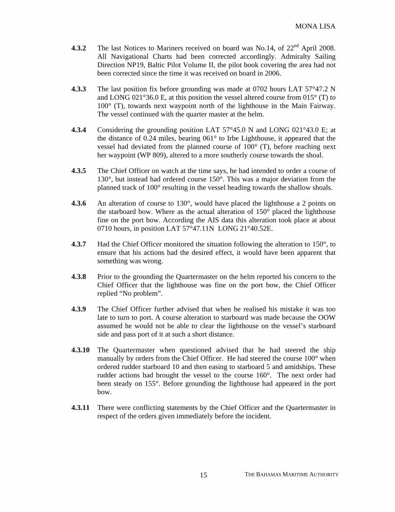
4.3.1 The navigation chart used during the grounding incident was BA Chart 2226, Entrance to the Gulf of Riga (1:100 000), Edition 2005, corrected up to NTM 14/2008. Chart datum was WGS 84, i.e. GPS positions could be plotted directly on this chart.
Reproduced from Admiralty chart 2226 by permission of the hydrographic office of the United Kingdom Reproduced from Admiralty chart 2226 by permission of the hydrographic office of the United Kingdom
MONA LISA
THE BAHAMAS MARITIME AUTHORITY 15
4.3.2 The last Notices to Mariners received on board was No.14, of 22nd April 2008. All Navigational Charts had been corrected accordingly. Admiralty Sailing Direction NP19, Baltic Pilot Volume II, the pilot book covering the area had not been corrected since the time it was received on board in 2006.
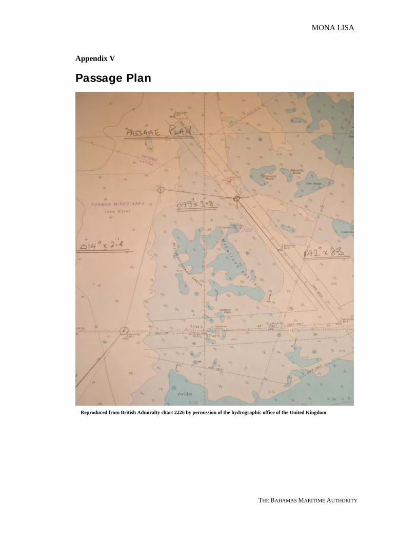
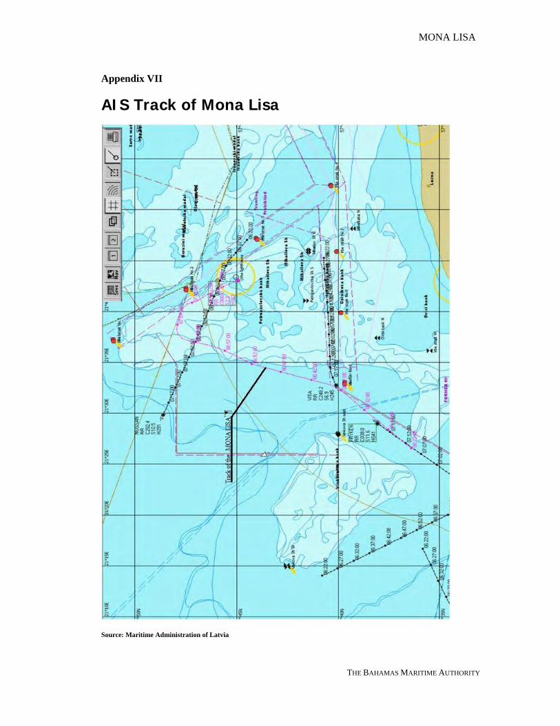
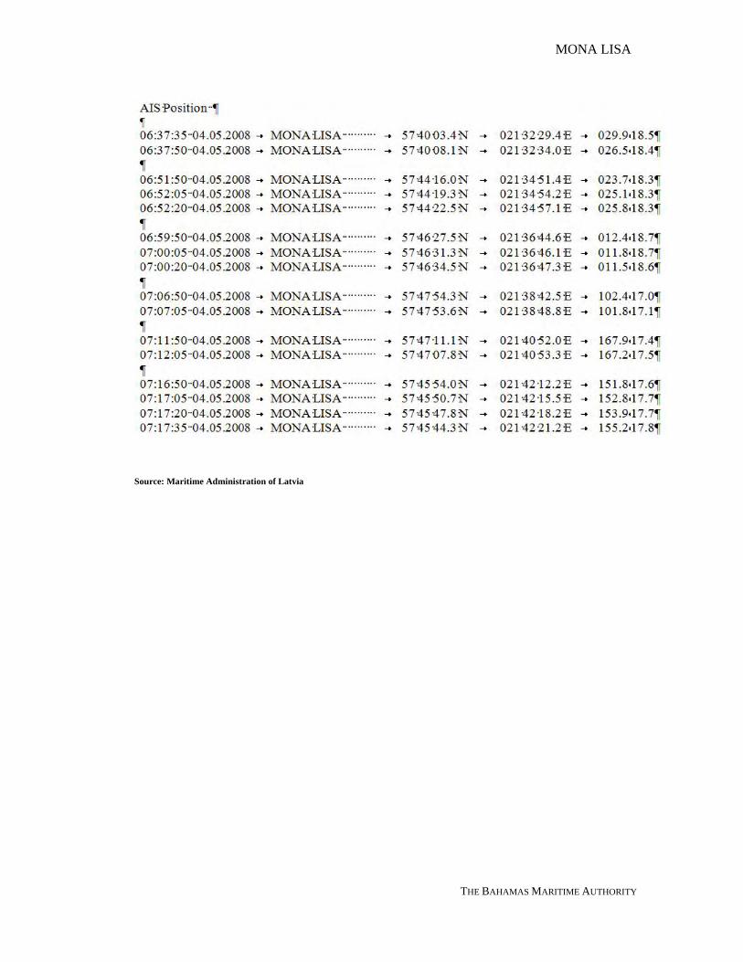
4.3.3 The last position fix before grounding was made at 0702 hours LAT 57°47.2 N and LONG 021°36.0 E, at this position the vessel altered course from 015° (T) to 100° (T), towards next waypoint north of the lighthouse in the Main Fairway. The vessel continued with the quarter master at the helm.
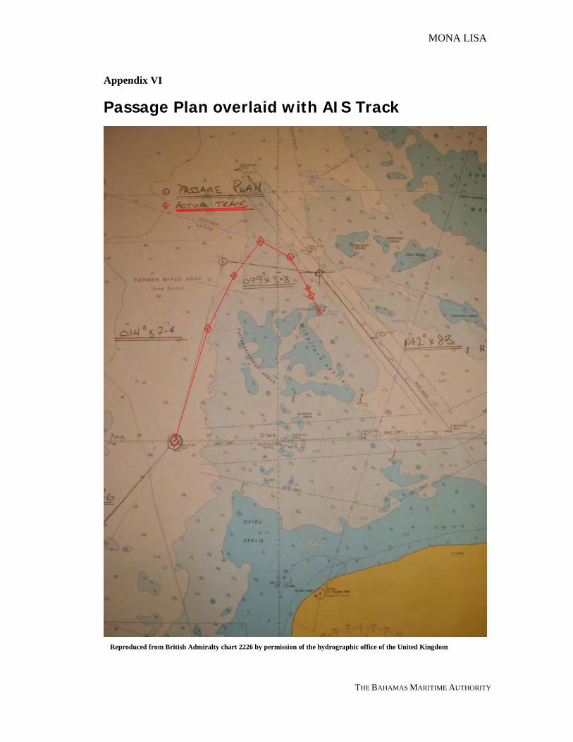
4.3.4 Considering the grounding position LAT 57°45.0 N and LONG 021°43.0 E; at the distance of 0.24 miles, bearing 061° to Irbe Lighthouse, it appeared that the vessel had deviated from the planned course of 100° (T), before reaching next her waypoint (WP 809), altered to a more southerly course towards the shoal.
4.3.5 The Chief Officer on watch at the time says, he had intended to order a course of 130°, but instead had ordered course 150°. This was a major deviation from the planned track of 100° resulting in the vessel heading towards the shallow shoals.
4.3.6 An alteration of course to 130°, would have placed the lighthouse a 2 points on the starboard bow. Where as the actual alteration of 150° placed the lighthouse fine on the port bow. According the AIS data this alteration took place at about 0710 hours, in position LAT 57°47.11N LONG 21°40.52E.
4.3.7 Had the Chief Officer monitored the situation following the alteration to 150°, to ensure that his actions had the desired effect, it would have been apparent that something was wrong.
4.3.8 Prior to the grounding the Quartermaster on the helm reported his concern to the Chief Officer that the lighthouse was fine on the port bow, the Chief Officer replied “No problem”.
4.3.9 The Chief Officer further advised that when he realised his mistake it was too late to turn to port. A course alteration to starboard was made because the OOW assumed he would not be able to clear the lighthouse on the vessel’s starboard side and pass port of it at such a short distance.
4.3.10 The Quartermaster when questioned advised that he had steered the ship manually by orders from the Chief Officer. He had steered the course 100° when ordered rudder starboard 10 and then easing to starboard 5 and amidships. These rudder actions had brought the vessel to the course 160°. The next order had been steady on 155°. Before grounding the lighthouse had appeared in the port bow.
4.3.11 There were conflicting statements by the Chief Officer and the Quartermaster in respect of the orders given immediately before the incident.
MONA LISA
THE BAHAMAS MARITIME AUTHORITY 16
4.4 Following the Grounding
4.4.1 The Chief Engineer had been on the bridge a few minutes before 0700 hours and
again shortly before the grounding and he had heard the OOW giving orders to alter course from 135° to 158°. However, he was not sure about remembering the figures correctly
4.4.2 The Master had been resting on the previous night since 0100 hours until the incident time at 0725 hours when he was woken by the grounding. He immediately came to the bridge.
4.4.3 The Master had issued written night orders for the watch officers, recorded in the Night Order Book and signed by the navigating officers:
• To maintain speed and course according to voyage plan; • To call the master whenever is necessary as per Master’s Standing Orders
and Bridge Procedures Guide; • Every officer must check waypoints on his duty and make a compass
error whenever permitted; • To keep safe distance 2 miles of any vessel in the vicinity in the open sea; • position taking by GPS to be verified by all GPS on the bridge. None of these orders had been followed by the Chief Officer.
4.4.4 Squat could likely have reduced the steering effectiveness when the vessel was nearing the shallow waters but it did not play a crucial role in the incident.
4.4.5 The weather did not play a role in the incident. It was fine weather at the time with slight sea and gentle breeze from WNW. Visibility was good. The currents in this area are relatively weak except when affected by strong winds. No such winds were recorded immediately prior to the incident.
4.4.6 There had been no shipping in the area at this time likely to has caused concern. A crossing vessel “NOSSAN” had been sighted before altering course 100° (i.e. before 0700 hours).
4.5 VDR – Model VER3000
4.5.1 The VDR hard disk serial no: 0412-326 was sent to the Flag Administration for investigation. The hard drive was reviewed in conjunction with the manufacturer on 19th May 2008. Playback of the hard drive revealed the VDR had stopped recording on the 3rd May 2008 0847 hours about when the vessel was in Gdynia. Data from the VDR also revealed the unit had suffered several glitches before the commencement of the cruise, while under repair and during the cruise. No data of any value to the investigation was obtained.
MONA LISA
THE BAHAMAS MARITIME AUTHORITY 17
4.5.2 An Annual Inspection in accordance with the relevant regulations was carried out by a Specialist Radio Surveyor on behalf of Class in Rotterdam on 23rd April 2008. All was found to be satisfactory. However within the Survey Schedule there is no evidence that the Data on the hard drive was recorded.
4.5.3 A subsequent visit to the “MONA LISA” on the 22nd May 2008 by the Flag Administration with the manufacturers’ representative to investigate the shortcomings of the VDR, identified that all the digital interfaces were satisfactory with the following exceptions: • No Speed Log data – SAL Log not in use, vessel in port. • No forward Echo Sounder data – Echo Sounder damaged in grounding
However there was again evidence of a break in recording the data to the hard drive.
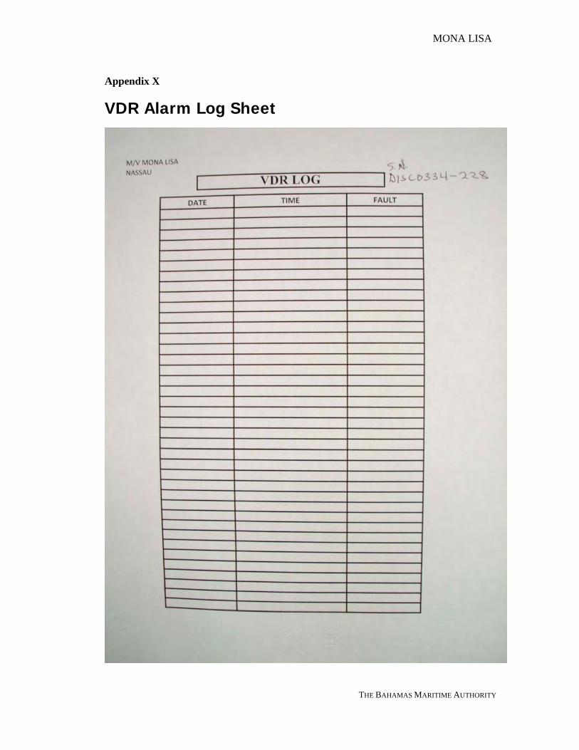
4.5.4 Following the visit to the ship, the “MONA LISA” was advised to keep a Log of
Alarms on the VDR, to identify the LCD fault code, this would assist in identifying the multiple recordings found on the VDR hard disk.
MONA LISA
THE BAHAMAS MARITIME AUTHORITY 18
5 CONCLUSIONS
5.1 The passenger cruise vessel “MONA LISA” grounded on a charted shoal west of Irbe Lighthouse off Latvian north coast on 04th May 2008 due to a navigational error on the part of the watch officer.
5.2 The Chief Officer on watch at the time was an experienced merchant marine officer, he had had sufficient rest hours and he was navigating the ship in good weather and visibility.
5.3 While approaching Irbe Lighthouse from the northwest the Chief Officer on watch at the time had made serious errors of judgement and omitting good navigational practices. Namely, ignoring the passage plan, the vessel deviated from the planned course of 100° and before reaching next waypoint (WP 809) altered a more southerly course towards the shoal.
5.4 The Chief Officer on watch at the time failed to properly monitor the vessel’s track during the turn. At some point the starboard turn placed the lighthouse straight ahead and the Chief Officer did not appreciate the vessel was now in imminent danger.
5.5 Fearful of altering course to port due to limited water space the Chief Officer on watch altered course further to starboard and passed the lighthouse on the vessel’s port hand. In fact had an alteration to Port been made, being deeper water, it is possible the grounding may have been avoided.
5.6 When realising that the vessel was passing on the wrong side of the lighthouse and that the grounding was imminent, a reduction in speed should have been considered, or reversing the engines.
5.7 There is no explanation as to the conduct of the Chief Officer. It is not apparent that he was engaged in any other activities likely to distract him from his duties as Officer of the Watch. Although according to the Quartermaster he appeared to be spending most of the time in the Chart Room. Despite concerns raised by the Quartermaster he failed to appreciate that he had placed the vessel in imminent danger.
5.8 The Master had not had much time to assess the capabilities of the navigating officers – he had joined the vessel a week prior to the grounding, while the Chief Officer had joined 10 days prior to the grounding – but nevertheless the Master was confident in the Chief Officer and assigned him the four to eight bridge watch.
MONA LISA
THE BAHAMAS MARITIME AUTHORITY 19
6 RECOMMENDATIONS
ACTIONS ALREADY TAKEN
Ship Managers
6.1 New Procedures for Bridge Team were set in place, with the introduction of a third person to be available at all times.
Flag Administration
6.2 Flag Administration requested an additional ISM Audit to take place prior to the commencement of the next voyage.
RECOMMENDATIONS
Ship Managers
6.3 The passage plan and Master’s orders were available but not properly followed by the watchkeeping officer. A more stringent control should be established over implementation of the voyage plan and understanding of the orders.
6.4 Consideration should be given to incorporate the bridge manning levels as part of the Passage Plan, to re-emphasise the need for adequate bridge manning at all times.
6.5 The VDR must be reset immediately the unit goes into alarm. If this problem persists a record of the Fault Codes must be kept, which may assist in the rectification of the problem.
IMO Nav Sub committee, Classification Societies
6.6 Consideration should be given to incorporating within the Annual Inspection Schedule of the VDR and SVDR, confirmation that all incoming data is safely stored on the secondary data storage facility and is in a readable format. In this instance although the VDR had been inspected 10 days prior to the grounding, subsequent investigation revealed regular glitches in the recording requiring the VDR to be reset.
MONA LISA
THE BAHAMAS MARITIME AUTHORITY
Appendix I
Ships Particulars

MONA LISA
THE BAHAMAS MARITIME AUTHORITY
Appendix II
Copy of actual Chart BA 2226 used
Reproduced from Admiralty chart 2226 by permission of the hydrographic office of the United Kingdom Reproduced from Admiralty chart 2226 by permission of the hydrographic office of the United Kingdom
MONA LISA
THE BAHAMAS MARITIME AUTHORITY
Appendix III
Bridge Watch Schedule prior to the grounding

MONA LISA
THE BAHAMAS MARITIME AUTHORITY
Appendix III a
Bridge Watch Schedule new schedule following the grounding
MONA LISA
THE BAHAMAS MARITIME AUTHORITY
Appendix IV
Entrance to the GULF of RIGA BA 2226 Passage Plan
Reproduced from Admiralty chart 2226 by permission of the hydrographic office of the United Kingdom Reproduced from British Admiralty chart 2226 by permission of the hydrographic office of the United Kingdom
MONA LISA
THE BAHAMAS MARITIME AUTHORITY
Appendix V
Passage Plan
Reproduced from British Admiralty chart 2226 by permission of the hydrographic office of the United Kingdom
MONA LISA
THE BAHAMAS MARITIME AUTHORITY
Appendix Va
Passage Plan
MONA LISA
THE BAHAMAS MARITIME AUTHORITY
Appendix VI
Passage Plan overlaid with AIS Track
Reproduced from British Admiralty chart 2226 by permission of the hydrographic office of the United Kingdom
MONA LISA
THE BAHAMAS MARITIME AUTHORITY
Appendix VII
AIS Track of Mona Lisa
Source: Maritime Administration of Latvia
MONA LISA
THE BAHAMAS MARITIME AUTHORITY
Source: Maritime Administration of Latvia
MONA LISA
THE BAHAMAS MARITIME AUTHORITY
Appendix VIII
View from Steering Position
MONA LISA
THE BAHAMAS MARITIME AUTHORITY
Appendix IX
VDR Playback Data
VDR Playback Data after the grounding
MONA LISA
THE BAHAMAS MARITIME AUTHORITY
Appendix X
VDR Alarm Log Sheet