Embed Size (px)
Citation preview

Moira Masseye-MapScholar Project Co-ordinator
Digimap e-MapScholar overview
The e-MapScholar project team
• Project is led by EDINA, a JISC-funded national data centre, based in the Data Library, University of Edinburgh
• Associate Partners at:– Dept of Geomatics at Newcastle
– Dept of Geography, Edinburgh
– Institute of Educational Technology at the OU
• Associates at 6 other Universities and LTSN Subject Centres, and Ordnance Survey
• More information available at:http://edina.ac.uk/projects/mapscholar/index.shtml
Digimap e-MapScholar
• Project started in January 2001 • Due to finish in April 2003• Aim is to develop tools and learning and teaching
materials that enhance and support the use of geo-spatial data in learning and teaching
• More specifically, the project will develop tools and learning materials to enhance the EDINA Digimap national service

EDINA Digimap
• Digimap is a web-based mapping service, offering access to Ordnance Survey digital map data
• National service, serving 52 HE institutions (more from September)
• Digimap offers an easy-to-use, map-based interface, allowing:– creation of maps on-screen – printing of high quality maps– downloading of digital map data for use in user’s own GIS
or graphics package– advanced cartographic services e.g. combining of
datasets, changing scale

Digimap - obtaining a map
Using data from Digimap in a GIS or drawing package
The Digimap Skills/Concepts Gap
Users need help to negotiate barriers arising from lack of skills/knowledge
Learning/skills curve

Digimap - obtaining a map
Bridging the Skills/Concepts Gap
Learning Materials
Tools
Increasing user sophistication
Learning/skills curve
Using data from Digimap in a GIS or drawing package

e-MapScholar Deliverables
• A range of Teaching Case Studies from a variety of subject areas - largely applications-based (by February 2002)
• Software tools and customisable learning materials (by April 2003):
- Working with digital map data
- Data integration
- Data visualisation (2D and 3D)• A proof-of-concept virtual placement, a real-life
problem-based exercise developed in partnership with an outside organisation (by April 2003)

Learning Materials in e-MapScholar
•As part of case studies by commissioned authors•As part of Work Package 5: Working with Digital Map Data (commissioned authors)•As part of Work Package 6: Data Integration (Dept of Geomatics, University of Newcastle)•As part of Work Package 7: Data Visualisation (Dept of Geography, University of Edinburgh)
Not simply for Digimap subscribing sites, as tools and materials can be used with OS Sample Datasets by any institution holding OS Copyright Licence (i.e. most)

Teaching Case Studies
• Characteristics:– Tutorial-type materials– Digimap service used alongside materials
provided to students– Typically, data downloaded from Digimap and
used, often with geo-spatial data from other sources, in a GIS or CAD package to provide applications-based learning package

Working with Digital Map Data
• Tools will include simple map querying and measurement, and simple data integration/customisation
• Learning materials will include concepts of geographic data, e.g. extent, scale and generalisation; how objects in the real world are portrayed within OS data; and how student should select data based on fitness for purpose

Data Integration
• Client-based tools will be developed that interact with the Digimap map and data server, to address geo-data tasks such as referencing, positioning, overlay and graphical editing
• Learning materials will focus on developing skills in, and understanding of, the integration of external data (e.g. census, remote sensing, environmental, as well as user-generated data e.g. GPS) with the OS data available through Digimap
Data Visualisation
• A range of tools will be developed that allow the visualisation of OS data in 2D and 3D
• Learning materials will focus on developing skills in, and understanding of, 2D and 3D visualisation and visual problem-solving techniques e.g. fitness for purpose, collecting data for visual problem-solving and working through the decision-making process

Aims of the Workshop
• Provide an opportunity to discuss the Teaching Case Studies
• Obtain input (and hopefully some commitment) to the project from teaching users
• Consult on concepts taught in working with digital map data, data integration and data visualisation, across subject areas

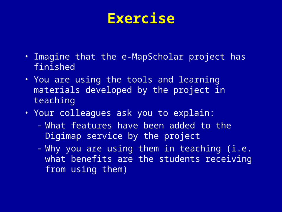
Exercise
• Imagine that the e-MapScholar project has finished • You are using the tools and learning materials
developed by the project in teaching• Your colleagues ask you to explain:
– What features have been added to the Digimap service by the project
– Why you are using them in teaching (i.e. what benefits are the students receiving from using them)

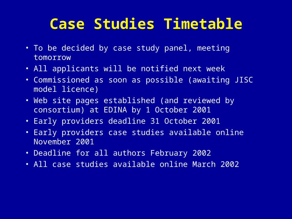
Case Studies Timetable
• To be decided by case study panel, meeting tomorrow• All applicants will be notified next week• Commissioned as soon as possible (awaiting JISC model
licence)• Web site pages established (and reviewed by consortium)
at EDINA by 1 October 2001• Early providers deadline 31 October 2001• Early providers case studies available online November
2001• Deadline for all authors February 2002• All case studies available online March 2002

Case Studies Discussion
• In which format(s) would you like to submit files?• Do you have any questions for us?