Embed Size (px)
Citation preview
© Environment Agency Copyright and/or database rights 2016. All rights reserved. © Crown copyright and database rights 2016. All rights reserved. Ordnance Survey licence number 100026380.Contact us: National Customer Contact Centre, PO Box 544, Rotherham, S60 1BY. Tel: 03708 506 506. Email:[email protected]
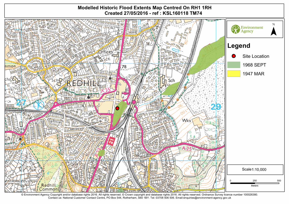
Modelled Historic Flood Extents Map Centred On RH1 1RH Created 27/05/2016 - ref : KSL160118 TM74
Scale
LegendSite Location1968 SEPT1947 MAR
¯
0 250 500Meters
1:10,000
Orchard House, Endeavour Park, London Road, Addington, West Malling, Kent, ME19 5SH. Customer services line: 01732 223 202 Email: [email protected] Website: https://www.gov.uk/government/organisations/environment-agency
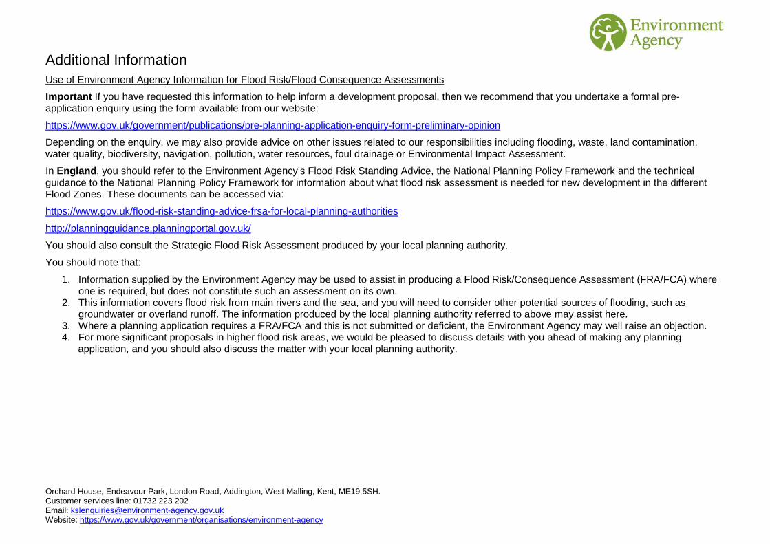
Additional Information Use of Environment Agency Information for Flood Risk/Flood Consequence Assessments
Important If you have requested this information to help inform a development proposal, then we recommend that you undertake a formal pre-application enquiry using the form available from our website:
https://www.gov.uk/government/publications/pre-planning-application-enquiry-form-preliminary-opinion
Depending on the enquiry, we may also provide advice on other issues related to our responsibilities including flooding, waste, land contamination, water quality, biodiversity, navigation, pollution, water resources, foul drainage or Environmental Impact Assessment.
In England, you should refer to the Environment Agency’s Flood Risk Standing Advice, the National Planning Policy Framework and the technical guidance to the National Planning Policy Framework for information about what flood risk assessment is needed for new development in the different Flood Zones. These documents can be accessed via:
https://www.gov.uk/flood-risk-standing-advice-frsa-for-local-planning-authorities
http://planningguidance.planningportal.gov.uk/
You should also consult the Strategic Flood Risk Assessment produced by your local planning authority.
You should note that:
1. Information supplied by the Environment Agency may be used to assist in producing a Flood Risk/Consequence Assessment (FRA/FCA) where one is required, but does not constitute such an assessment on its own.
2. This information covers flood risk from main rivers and the sea, and you will need to consider other potential sources of flooding, such as groundwater or overland runoff. The information produced by the local planning authority referred to above may assist here.
3. Where a planning application requires a FRA/FCA and this is not submitted or deficient, the Environment Agency may well raise an objection. 4. For more significant proposals in higher flood risk areas, we would be pleased to discuss details with you ahead of making any planning
application, and you should also discuss the matter with your local planning authority.
Orchard House, Endeavour Park, London Road, Addington, West Malling, Kent, ME19 5SH. Customer services line: 01732 223 202 Email: [email protected] Website: https://www.gov.uk/government/organisations/environment-agency
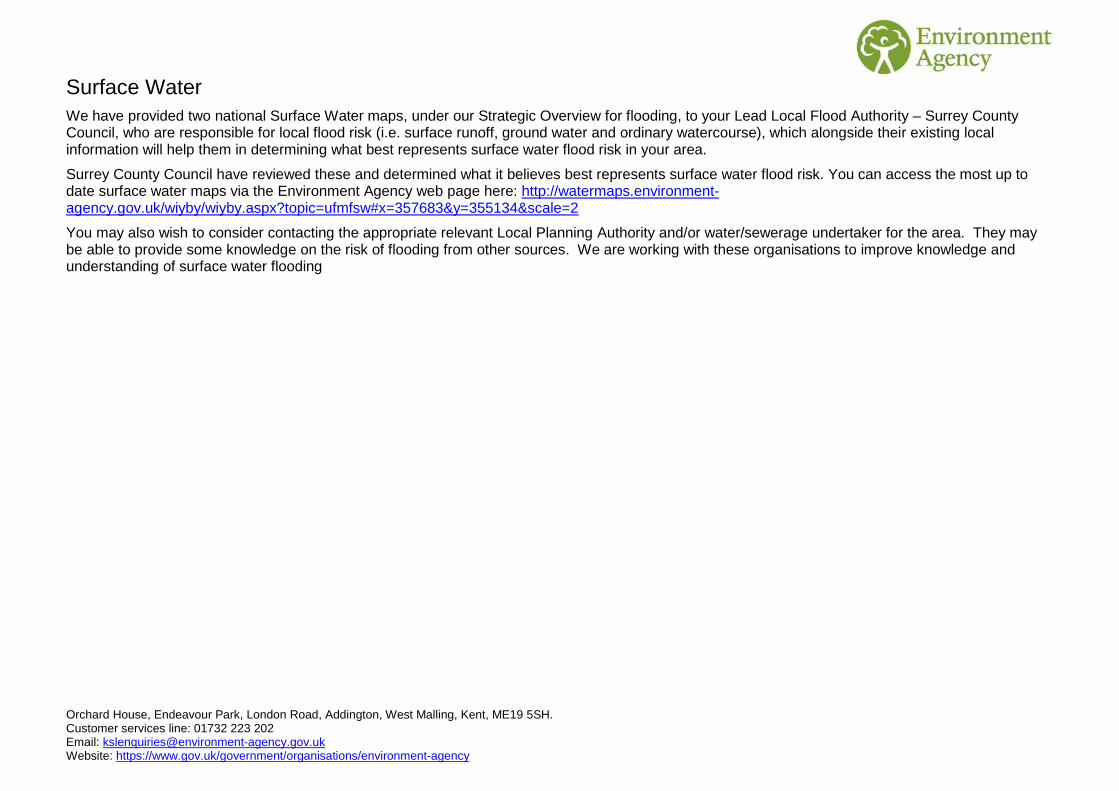
Surface Water We have provided two national Surface Water maps, under our Strategic Overview for flooding, to your Lead Local Flood Authority – Surrey County Council, who are responsible for local flood risk (i.e. surface runoff, ground water and ordinary watercourse), which alongside their existing local information will help them in determining what best represents surface water flood risk in your area.
Surrey County Council have reviewed these and determined what it believes best represents surface water flood risk. You can access the most up to date surface water maps via the Environment Agency web page here: http://watermaps.environment-agency.gov.uk/wiyby/wiyby.aspx?topic=ufmfsw#x=357683&y=355134&scale=2
You may also wish to consider contacting the appropriate relevant Local Planning Authority and/or water/sewerage undertaker for the area. They may be able to provide some knowledge on the risk of flooding from other sources. We are working with these organisations to improve knowledge and understanding of surface water flooding

Orchard House, Endeavour Park, London Road, Addington, West Malling, Kent, ME19 5SH. Customer services line: 01732 223 202 Email: [email protected] Website: https://www.gov.uk/government/organisations/environment-agency
Open Government Licence
Please refer to the Open Government Licence which explains the permitted use of this information.

SITE SPECIFIC FLOOD RISK ASSESSMENT
Report Title: Marketfield Way, Redhill – Mixed Use Development
Client: Reigate & Banstead District Council & Co Plan Estates Project no: 45110 – Rev. D
Appendix J
MLM Consulting Ltd Main Tel: 020 7422 7800
3rd Floor Eldon House, 2 Eldon Street, London, EC2M 7LS
Marketfield Way, Redhill
Below Ground Drainage
Operation and Maintenance Schedule
Document Ref: NDA/581203 Prepared: Darragh O’Connell
Revision: 0 Civil engineer
Date: 30 August 2016
Checked: Ben Freedman
Director
Marketfield Way, Redhill © MLM Consulting Ltd Below Ground Drainage Operation & Maintenance Schedule
MV \\MLMIPS.com\Work\MLM\5_\581_\58120_\581203\REP
Project Revision Sheet
Revision No Date Status Changes Author Approved
0 30/08/2016 First Issue - D O’Connell B Freedman
Marketfield Way, Redhill © MLM Consulting Ltd Below Ground Drainage Operation & Maintenance Schedule
MV \\MLMIPS.com\Work\MLM\5_\581_\58120_\581203\REP
Contents
Page
1 Operation and Maintenance 1
1.1 Below Ground drainage 1
1.2 Catchpits & Silt Traps 1
1.3 Linear drainage / Surface Channels 1
1.4 Flow controls: HydroBrake/Orifice plate 1
1.5 Green Roofs 2
1.6 Cellular Storage 3
Marketfield Way, Redhill © MLM Consulting Ltd Below Ground Drainage Operation & Maintenance Schedule
MV \\MLMIPS.com\Work\MLM\5_\581_\58120_\581203\REP 1
1 Operation and Maintenance
To ensure that below ground drainage networks continue to perform efficiently, it
is essential that the networks are appropriately & regularly maintained. Inspection
of the storm water chambers, flow restrictions, pumps and rising mains should be
carried out on a regular basis and in particular after every large storm event. Where
products are installed, maintenance should be carried out to manufacturers’
specifications. Further information on the operation and maintenance of specific
components of the drainage network is outlined below.
1.1 Below Ground drainage
It is recommended that the below ground drainage network is regularly maintained
in accordance with the Building Regulations Part H, BS EN752 and the
manufacturers specifications.
1.2 Catchpits & Silt Traps
The maintenance of catchpits, silt traps and other interceptors is vital in order to
ensure that grits, debris and other detritus does not enter the below ground
drainage system or storm water attenuation tanks. Cleaning of catchpits and silt
traps should be cleaned by mechanical means and to manufacturers’
specification.
1.3 Linear drainage / Surface Channels
Surface linear channels, eg ACO channels, should be inspected and cleaned
out/jetted on a regular basis to ensure clear flow of surface water enters the
drainage system.
1.4 Flow controls: HydroBrake/Orifice plate
Orifice plates or any other discharge restrictor such as a HydroBrake™ should be
regularly checked after a major storm to ensure that they are free from blockage
and reviewed annually.
It is recommended that the minimum aperture is 75mm to avoid blockages. For a
restriction of less than 75mm, the orifice plate must undergo regular maintenance
and monitoring. Further information about flow restriction maintenance should be
in line with the manufacturers’ recommendations.
It is of utmost importance that the chamber is kept clean of foreign objects such as
branches, leaves etc. Maintenance should be in line with the manufacturers’
recommendations which for a Hydrobrake suggests that after commissioning, the
flow control is inspected monthly for the first three months of operation and
thereafter every six months.
Marketfield Way, Redhill © MLM Consulting Ltd Below Ground Drainage Operation & Maintenance Schedule
MV \\MLMIPS.com\Work\MLM\5_\581_\58120_\581203\REP 2
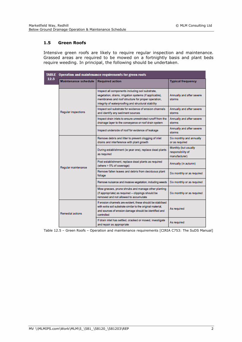
1.5 Green Roofs
Intensive green roofs are likely to require regular inspection and maintenance.
Grassed areas are required to be mowed on a fortnightly basis and plant beds
require weeding. In principal, the following should be undertaken.
Table 12.5 – Green Roofs – Operation and maintenance requirements [CIRIA C753: The SuDS Manual]
Marketfield Way, Redhill © MLM Consulting Ltd Below Ground Drainage Operation & Maintenance Schedule
MV \\MLMIPS.com\Work\MLM\5_\581_\58120_\581203\REP 3
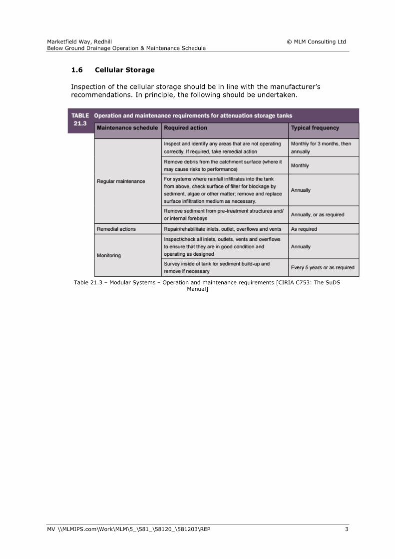
1.6 Cellular Storage
Inspection of the cellular storage should be in line with the manufacturer’s
recommendations. In principle, the following should be undertaken.
Table 21.3 – Modular Systems – Operation and maintenance requirements [CIRIA C753: The SuDS
Manual]
SITE SPECIFIC FLOOD RISK ASSESSMENT
Report Title: Marketfield Way, Redhill – Mixed Use Development
Client: Reigate & Banstead District Council & Co Plan Estates Project no: 45110 – Rev. D
Appendix K