Embed Size (px)
Citation preview

Modeling Soil Moisture in the Mojave Desert
By David M. Miller, Debra Hughson, and Kevin M. Schmidt
Open-File Report 2008-1100
U.S. Department of the Interior U.S. Geological Survey

U.S. Department of the Interior DIRK KEMPTHORNE, Secretary
U.S. Geological Survey Mark Myers, Director
U.S. Geological Survey, Reston, Virginia 2008
For product and ordering information: World Wide Web: http://www.usgs.gov/pubprod Telephone: 1-888-ASK-USGS
For more information on the USGS—the Federal source for science about the Earth, its natural and living resources, natural hazards, and the environment: World Wide Web: http://www.usgs.gov Telephone: 1-888-ASK-USGS
Suggested citation: Miller, D.M., Hughson, D. and Schmidt, K.M. , 2008, Modeling Soil Moisture in the Mojave Desert.: Geological Survey Open-File Report 2008-1100, 6 pages.
Any use of trade, product, or firm names is for descriptive purposes only and does not imply endorsement by the U.S. Government.
Although this report is in the public domain, permission must be secured from the individual copyright owners to reproduce any copyrighted material contained within this report.

USGSscience for a changing world
Modeling Soil Moisture in the Mojave DesertOpen-File Report 2008-1100
The Mojave Desert is an arid region of south-eastern California and parts of Nevada,
Arizona, and Utah; the desert occupies more than 25,000 square miles (fig. 1). Ranging from below sea level to over 5,000 feet (1,524 m) in elevation, the Mojave Desert is considered a “high desert.” On the west and southwest it is bounded by the Sierra Nevada, the San Gabriel, and the San Bernardino Mountains. These imposing moun-tains intercept moisture traveling inland from the Pacific Ocean, producing arid conditions char-acterized by extreme fluctuations in daily tem-peratures, strong seasonal winds, and an average annual precipitation of less than six inches. The Mojave Desert lies farther south and at a lower elevation than the cooler Great Basin Desert and grades southward into the even lower and hotter Sonoran Desert.
In hot dry landscapes, such as the Mojave Desert, the competition for water, and thus survival, is intense. Even though dry most of the time, the countless washes, gullies, and rills, and the vegetation associated with them, attest to the importance of precipitation in the desert ecosystem (figs. 2 and 3). Because streams, springs, and wetlands exist only in a tiny fraction of the desert, virtually all organisms make use of water stored in soils.
Addressing the questions of how water moves into and through the soil and how plants take advantage of water is criti-cal to understanding how biota survive in these water-limited lands. The ability of plants and animals to utilize moisture
in desert soils is largely dependent upon four factors: (1) the amount and timing of precipitation events, (2) the rate of evaporation, (3) the distribution of plant cover and relative plant water needs, and (4) the characteristics of the soil itself. While desert moisture dynamics are driven primarily by precipitation and evaporation, soil attributes such as texture and structure are fundamental to how water is utilized by plants. Because soil moisture is a vital element of arid ecosystem processes, the US Geological Survey is creating models of soil moisture, which are valuable tools that can be used in making land management decisions.
U.S. Department of the InteriorU.S. Geological Survey
Figure 1. Location of the Mojave Desert region and the principal mountain ranges that block storm precipitation.
Figure 2. This active dry wash demonstrates that, although dry most of the time, streams flow repeatedly in the desert. Plant life is limited in washes because of floods and abrasion by flowing sand and gravel, but plants next to the wash are larger than normal and probably take advantage of supplemental water from streamflow. This photo by D. M. Miller, USGS, was taken after a wet winter and spring; the abundant grasses and flowers next to the wash have responded to the favorable conditions.
Mojave DesertEcoregion
Los Angeles
Las Vegasasgaa
AZ
UTNVSierra
NevadaMtns.
San GabrielMtns. San Bernardino
Mtns.
CA
PacificOcean
March 2008

BackgroundAs desert soil develops over time (the process of pedogen-
esis), the texture of the upper part of geologic deposits changes, primarily with addition of windblown silt and clay but also with weathering, salt deposition, and incorporated plant remains. The soil develops layers, or horizons, which tend to be parallel to the ground surface. Each soil horizon has unique characteristics that differentially affect moisture infiltration and retention. In the Mojave, wind-blown dust, which slowly migrates downward into coarse stony deposits, transforms each horizon into a pro-gressively finer-textured deposit (fig. 4). The surface is capped by a pavement of stones.
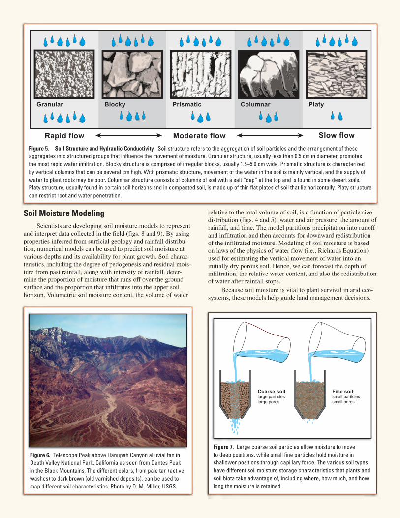
The rate of rain-water flow through the soil horizons is determined, in part, by each horizon’s hydraulic conductiv-ity. Hydraulic conductivity, a measure of the rate water flows through a material, is a function of the number of pores or spaces between soil particles and aggregates. The pore space depends upon the particle size, shape, structure, and packing. Sands, for example, have a granular structure and more pore space, and thus higher hydraulic conductivities than clays, which have a platy structure and less pore space (fig. 5).
Much of the Mojave Desert is made up of coarse-grained, stony alluvial fan materials (fig. 6). Moisture drains readily by gravity in coarser soils, while fine-grained soils have pores small enough to hold water by capillary force, which reduces conductivity (figs. 5 and 7). This inhibits gravity drainage and holds the moisture in place, where it can be used by plants. Some soil layers with very low conductivities can act as barri-ers, preventing water infiltrating to lower soil horizons.
Infiltration and soil moisture redistribution depend not only on soil physical properties but also on the location of vegetation. The relationship between soil moisture and plants is a challeng-ing field of active research. While the uptake of soil moisture by plants depends on the subsurface distribution of active roots, those roots alter the soil properties, changing infiltration and soil moisture retention. In addition, soil moisture can be trans-ported from wetter to drier soil through a plant’s xylem (tube-like plant cells that primarily conduct water and nutrients from roots to leaves) via a process known as hydraulic redistribution.
Soil moisture is also affected by evaporation from the sur-face. Drying of the uppermost soil layer pulls moisture upward due to capillary pressure, but as the soil dries this mechanism for water flow becomes very inefficient. Water vapor contin-ues to migrate, creating a diurnal moisture content cycle as the upper layer is dried during the day and re-wetted at night by upward vapor flow.
Based on these principles, an optimal location for a long-lived desert perennial shrub, such as Larrea tridentata (creosote bush), is where it can take advantage of both brief, intense sum-mer thunderstorms and soil moisture held in fine-textured soils from gentle winter precipitation (fig. 8). A successful strategy, therefore, is to have deep roots in granular soils and shallow roots in fine-textured soils. Stream flow may also add extra water to soils under and near washes. This explains why peren-nial plants along the margins of active washes in alluvial fans grow larger than on the older surfaces between active washes (fig. 2).
Figure 3. Flash flood in a channel of the Avawatz Mountains alluvial fan as it exits onto California State Highway 127 in Silurian Valley. Photo April 30, 1999 by D. M. Miller, USGS.
Figure 4. Pedogenesis. Simplified illustration of soil development in Pleistocene-age alluvial fan deposits typical of the eastern Mojave Desert. Soil horizons are denoted as follows: Av—vesicular A, a silt-rich cap containing small cavities, or vesicles, which forms under desert pavement; Bw—cambic B, characterized by weak cementation, as well as the addition of silt, minor amounts of clay, and a slight reddish color; Bt—argillic B, characterized by stronger cementation, a strong reddish color, as well as the addition of substantial silt and clay; Bk—calcic B, characterized by progressive addition of calcium carbonate that first coats clasts and later fills in the matrix.
Stony desert pavement
Av (vesicular) horizon withweak vertical soil structures
Bk (calcic) horizonwith fractures and
thin layering at the top
Bt (argillic) clay-richhorizon with strong
vertical soil structures
Bw (cambic) horizon withweak vertical soil structures
Soil Moisture ModelingScientists are developing soil moisture models to represent
and interpret data collected in the field (figs. 8 and 9). By using properties inferred from surficial geology and rainfall distribu-tion, numerical models can be used to predict soil moisture at various depths and its availability for plant growth. Soil charac-teristics, including the degree of pedogenesis and residual mois-ture from past rainfall, along with intensity of rainfall, deter-mine the proportion of moisture that runs off over the ground surface and the proportion that infiltrates into the upper soil horizon. Volumetric soil moisture content, the volume of water
relative to the total volume of soil, is a function of particle size distribution (figs. 4 and 5), water and air pressure, the amount of rainfall, and time. The model partitions precipitation into runoff and infiltration and then accounts for downward redistribution of the infiltrated moisture. Modeling of soil moisture is based on laws of the physics of water flow (i.e., Richards Equation) used for estimating the vertical movement of water into an initially dry porous soil. Hence, we can forecast the depth of infiltration, the relative water content, and also the redistribution of water after rainfall stops.
Because soil moisture is vital to plant survival in arid eco-systems, these models help guide land management decisions.
Figure 5. Soil Structure and Hydraulic Conductivity. Soil structure refers to the aggregation of soil particles and the arrangement of these aggregates into structured groups that influence the movement of moisture. Granular structure, usually less than 0.5 cm in diameter, promotes the most rapid water infiltration. Blocky structure is comprised of irregular blocks, usually 1.5–5.0 cm wide. Prismatic structure is characterized by vertical columns that can be several cm high. With prismatic structure, movement of the water in the soil is mainly vertical, and the supply of water to plant roots may be poor. Columnar structure consists of columns of soil with a salt “cap” at the top and is found in some desert soils. Platy structure, usually found in certain soil horizons and in compacted soil, is made up of thin flat plates of soil that lie horizontally. Platy structure can restrict root and water penetration.
Figure 6. Telescope Peak above Hanupah Canyon alluvial fan in Death Valley National Park, California as seen from Dantes Peak in the Black Mountains. The different colors, from pale tan (active washes) to dark brown (old varnished deposits), can be used to map different soil characteristics. Photo by D. M. Miller, USGS.
Figure 7. Large coarse soil particles allow moisture to move to deep positions, while small fine particles hold moisture in shallower positions through capillary force. The various soil types have different soil moisture storage characteristics that plants and soil biota take advantage of, including where, how much, and how long the moisture is retained.
Coarse soillarge particleslarge pores
Fine soilsmall particlessmall pores
Granular Prismatic PlatyBlocky Columnar
Rapid flow Moderate flow Slow flow

Soil moisture characteristics help explain why some areas provide a more suitable habitat for rare plants, important species such as Yucca brevifolia (Joshua tree), and bio-logical soil crusts. In order to protect threatened and endangered species, such as the desert tortoise, land managers need to be able to recog-nize suitable habitats, which includes understanding plant communities that provide forage for the animals. An understanding of soil moisture is also essential for restoring disturbed areas such as abandoned mine lands; land managers must determine the most suitable plants for revegetation and the proper irrigation methods so the plants survive. In addition, our ability to predict soil moisture availability under future rainfall scenarios may govern success in restoring desert plant communities.
David Miller,US Geological Survey
Debra Hughson,National Park Service
Kevin Schmidt,US Geological Survey
Design and layout by Tina Kister
0.35
0.30
0.20
0.15
0.10
0.05
00 5 10 15 20
Time elapsed (hrs)
Volu
met
ric
soil
moi
stur
e
0.25
3 cm10 cm
25 cm50 cm
Model
Figure 8. Effect of Soil Permeability. These graphs of model simulations illustrate the contrasting soil moisture profiles for coarse-grained and fine-grained soils and for two model rainfalls: an intense, 1-hour summer thunderstorm and a gentle, 24-hour winter rain. In coarse soil, on the left, water infiltrated 15 cm at the end of the summer storm (1 hour) and more deeply after 24 hours. During the winter storm, however, rain falls gently throughout the day and infiltrates deeply into the coarse soil, providing more soil moisture than is provided by the brief summer storm. For the fine soil on the right, rain falls too rapidly during the summer storm to completely infiltrate (some runs off into streams), and the wetting front infiltrates only to about 7 cm, even after 24 hours. The winter storm penetrates more deeply into the fine soil because none of the rain runs away during the gentle rainfall, but it only penetrates to about 20 cm. Plants with a shallow root system may prefer the fine soil, while those with deep roots will do better in coarse soils.
Figure 9. This graph compares the soil moisture recorded during a rain event (February 3, 2004, which lasted 2.5 hours and totaled 7.6 mm) and model simulations. Soil moisture probes buried at 3, 10, 25, and 50 cm in Pleistocene-age deposits (with strong soil horizons) record shallow infiltration only, with the shallowest probe wetting rapidly and then drying slowly, while the 10-cm deep probe becomes wet more slowly. Moisture does not penetrate to 25 cm. This real-world example provides validation for the models.
Volumetric soil moisture
Fine soil(Vesicular A)
Dep
th (c
m)
0
5
10
15
20
25
30
35
400.00 0.05 0.10 0.15 0.20 0.25 0.30 0.400.35
Coarse soil(Active wash)
24-hr Winter storm24-hr Summer storm1-hr Summer storm
Recoverability and Vulnerability of Desert Ecosystems
Soil moisture models are being developed through the Recoverability and Vulnerability of Desert Ecosystems (RVDE) program, which is an interdisciplinary, ecosystem-based pro-gram designed to create scientific tools for land managers to use as they work to conserve and restore desert landscapes.
See also http://geography.wr.usgs.gov/news/docs-04/RVDE_FS058-03.pdf
For more information please con-
tact:David Miller US Geological Survey345 Middlefield Road, MS-973