Embed Size (px)
Citation preview

Model Selection 227
8MODEL SELECTION REQUIREMENTS
8.1 Introduction
Laguna de Santa Rosa is currently listed as impaired on California’s Section 303(d) list (the TMDL list) for dissolved oxygen, temperature, nutrients and sediment. Other concerns for the management of the Laguna include flooding (partially due to backflow from the Rus-sian River), Ludwigia infestation, and ecosystem/habitat integrity–all of which are linked in various ways to the impairment listing criteria. Therefore, water quality, flood protection and restoration planning are all main areas of concerns in basin management.
Figure 8-1 Key components and linkages among components in modeling framework
The Laguna de Santa Rosa conceptual model study has identified three major categories to be addressed in basin management and planning: hydrology, water quality, and ecosystems. Mathematical simulation models can provide a tool for evaluating and summarizing the complex interrelationships between stressors and responses in the Laguna, and are needed

228 The Altered Laguna
to assess to different management alternatives. The purpose of this section is to discuss ex-isting modeling efforts, evaluate requirements for a linked modeling system appropriate to address management needs, and recommend a modeling framework that can evaluate the linkages between the components identified in the conceptual models (Figure 8-1). This section includes model selection recommendations for two of the three components in-cluded in this study: hydrology and water quality. The ecosystem component is addressed partially under the water quality model component; however, some aspects of this com-ponent cannot be fully addressed through mathematical models given the current state of knowledge.
8.2 Preliminary model recommendations
The current report lays the foundation for establishing future monitoring and modeling needs for the Laguna de Santa Rosa. It is evident from the discussions in this section that there is not a single modeling tool that meets all management needs. It is also evident that there remains considerable uncertainty about which modeling tools should be chosen. Pre-liminary recommendations are made here; however, these should be regarded as prelimi-nary and should be followed up with a formal model selection process.
It will also be important to develop monitoring and modeling needs in tandem. There is much that is still unknown about the functioning of this complex system that can best be answered through direct observation (rather than modeling). Further, models are, at best, only as good as the data that drive them, and the shortcomings of existing data will impede the creation of credible models unless remedied. So, developing monitoring and modeling plans in tandem will be the best way to provide for the long-term understanding and man-agement of this unique ecosystem.
While additional data are clearly needed, the proposed schedule for the TMDL will require development and application of modeling tools in a shorter time frame that is in-compatible with filling all the identified data gaps. Given this requirement, there is a clear advantage toward (1) selecting models that are not more complex than is needed to meet decision needs, and (2) choosing models already under development as part of the toolkit, where appropriate. Note that it is always possible–and often advisable–to begin with sim-pler models and move to more complex models later, and only as needed.
The first, and perhaps the most important, step in any modeling project is to clearly define modeling objectives (McKeon and Segna, 1987). Selection of an appropriate model or system of models involves a wide range of technical and practical considerations (No-votny and Olem, 1994). The criteria for model definition can be described in three general categories (expanding on the classification of Mao, 1992): Technical Criteria, Regulatory Criteria, and User (Functional & Operational) Criteria.
Technical Criteria comprise the match of the model to the physical/chemical charac-teristics of the system and contaminants. They reflect whether the model is appropriate for the system being described and supports the scientific defensibility of the results.
Physical Domain. One of the most obvious of the technical criteria for model defini-tion is the physical domain that must be simulated, potentially including both upland areas and receiving water. For instance, different model requirements may be present for rivers versus lakes or for load generation from urban versus agricultural areas.

Model Selection 229
Constituents Simulated. A critical component of model definition is determining which constituents will need to be simulated. The more state variables that are included, the more difficult the model will be to implement and calibrate, as the model is likely to be over-specified relative to the data. On the other hand, if important state variables are omit-ted from the simulation the model may be unable to answer necessary questions.
Temporal Representation and Scale. Models may be classified as steady-state or dy-namic in their representation of a given process. Steady-state models represent the ultimate response to a steady load and cannot capture the time course of responses to time-vary-ing inputs. Dynamic models represent temporal variability. Where dynamic processes are represented there are usually limits on the time steps or temporal representations that are appropriate for a given model. Lumped parameter models usually have a minimum time step below which the simplifying assumptions used in model development do not permit accurate representation.
Spatial Representation and Scale. The physical representation of the watershed and waterbody is an important consideration in determining system requirements. These re-quirements include the manner in which different landuses and waterbodies are modeled, as well as the scale at which the model is developed. Similar to the temporal representation, there are limits on the spatial increments that are appropriate for a given model.
Regulatory Criteria reflect the fact that most watershed modeling efforts are driven, at least in part, by compliance with water quality standards and other regulatory criteria, such as floodplain delineation. The model needs to supply answers to specific regulatory questions and with a degree of defensibility acceptable to the regulatory agency. Important regulatory criteria for the Laguna include the need for FEMA-acceptable models for flood-plain delineation and the use of public-domain models for the TMDL.
User Criteria comprise the functional and operational needs of the user. These criteria include the general requirements for system development and will involve consideration of such issues as available resources, ease of use, and communicability of results. Because the model may be used for planning and permitting decisions, basic functional needs include a model that is well documented, tested, and accepted. From an operational perspective, the level of effort required for model calibration must be commensurate with the project bud-get, without compromising the ability to meet technical criteria.
Functional needs refer to such issues as ease of use and communication of results, availability and adequacy of documentation, and extent of data requirements. The level of effort required to couple particular runoff and receiving water models can be an important functional criterion. Use of a highly complex model will increase the difficulty of under-standing, communicating, and gaining acceptance of the results.
Operational needs reflect both the requisite technical ability to implement the model, and the estimate of cost and time requirements for the implementation (including data gathering). These criteria provide the cost side for any cost-benefit analysis of model selec-tion. Both cost and time requirements of modeling can be important constraints.
Based on our current understanding of modeling needs, we believe there are consider-able potential advantages in working with the existing RMA-2/RMA-11 models for the Laguna – pending completion and review of an acceptable model calibration/validation report. Consideration should be given to the need to expand to two dimensions or refine the model segmentation, but many of the basic components seem to be already in place.

230 The Altered Laguna
Further, the RMA models should meet the requirements of both the TMDL and FEMA floodplain delineation.
A SWAT model is also in development for the watershed, and use should be made of this effort where appropriate – again pending completion and review of an acceptable model calibration/validation report. The upland component of SWAT is generally suitable for the sediment loading and pollutant loading portions of needed TMDL and watershed management (if run in sub-daily mode). On the other hand, SWAT has a number of defi-ciencies for simulation of transport through the stream network. SWAT is also not accepted for FEMA projects, nor is it recommended for flooding studies.
To address the watershed and upland hydrology needs of flooding studies, HEC-HMS is a well-accepted and moderate complexity tool of choice and is recommended. SWAT and HEC-HMS would then be run in parallel on the uplands – but could well share much data in common. While the MIKE family of models could handle both components simultane-ously, these are – at least in theory – in appropriate for TMDL application.
For the stream network pollutant transport component, a more thorough needs analy-sis should be conducted to determine if SWAT’s deficiencies disqualify its use. To answer questions on the basis only of gross loading over time, SWAT is likely sufficient; however, to address instream transformations and kinetics, a more sophisticated tool is needed. This role could be supplied by HSPF’s reach component, which can readily be linked to the up-land component of SWAT.
HSPF can draw information from HEC-HMS. Even though, the HMS model does not directly output information used to formulate the input data to the HSPF (F Tables: relationship between reach volume and discharge), it includes the information necessary to generate F Tables if developed using a particular routing routine (Muskingum-Cunge routine). HMS input and output can be analyzed to calculate the information required to formulate the F Tables that represent hydraulics within HSPF.
In sum, a reasonable candidate modeling system to meet the variety of simulation needs in the Laguna de Santa Rosa watershed would build on existing efforts and consist of a linked set of models, incorporating HEC-HMS, SWAT, HSPF, and RMA-2/RMA-11. A conceptual strawman diagram is shown in Figure 8-2.

Model Selection 231
HEC-HMS
SWAT
HSPF RCHRES
RMA 2/RMA 11
Uplands
Stream Network
Laguna de Santa Rosa
FTabs
Loading
Event Flow Continuous Simulation
HEC-HMSHEC-RAS
SWAT
HSPF RCHRES
RMA 2/RMA 11
Uplands
Stream Network
Laguna de Santa Rosa
FTabs
Loading
Event Flow Continuous Simulation
Figure 8-2 Conceptual strawman for Laguna de Santa Rosa and watershed modeling system
8.3 Existing model applications
Currently there are several ongoing modeling efforts in the basin conducted by different agencies to look at flood protection, sedimentation and water quality. These efforts include the application of SWAT model by NASA Ames and the Laguna Foundation (described below and previously in section 4.1 for hydrology and Sediment), the RMA-2/RMSA-11 modeling efforts by City of Santa Rosa for flow and water quality (described below) and USGS for sedimentation (described previously in Section 4.1), and hydrologic modeling using HEC-HMS being conducted by the Army Corps of Engineers (USACE; described previously in Section 4.1).
8.3.1 SWAT (NASA AMES)
SWAT is a continuous simulation watershed model developed by the USDA Agricultural Research Service that is particularly appropriate for evaluating runoff and pollutant loading from agricultural lands. (The strengths and weaknesses of the SWAT approach are discussed further in Section 8.4). The application of the SWAT model to the Laguna de Santa Rosa watershed is an ongoing effort led by NASA Ames and the Laguna Foundation (Arnold et al. 1998; C. Potter and S. Hyatt, personal communication). The model is currently imple-mented for the period of 2000–2006 to simulate hydrology, sediment, nutrients (nitrogen
232 The Altered Laguna
and phosphorus) and dissolved oxygen. The watershed is segmented into around 200 sub-basins. A total of five precipitation stations (with three extending back to 1948) were used in model calculation. The soil data used were an updated SSURGO soil data layer based on county-level soil surveys. The land cover dataset used is an updated National Land Cover Dataset (NLCD) in 30 meter resolution merged with the California Department of Water Resources (DWR) crop type polygons and Sonoma County Assessor’s Parcel descriptions (C. Potter and S. Hyatt, personal communication). NAIP (National Agricultural Imagery Program) digital ortho imagery data were used to confirm the merged land cover product in key areas of uncertainty.
Preliminary model results indicate reasonable performance in simulating stream flow on a monthly basis (R2 > 0.9 for years 2001-2006) for Santa Rosa Creek (USGS 11465800 Santa Rosa Creek near Santa Rosa, USGS 1466200 Santa Rosa Creek at Santa Rosa, and USGS 11466320 Santa Rosa Creek at Willowside Road). However, a detailed calibration report has not been prepared, and the ability of the model to simulate hydrology on shorter time steps in this watershed has not yet been demonstrated. Currently, the model is used to simulate pollutant loadings from natural vegetation, croplands, pastures, and urban storm water runoff. Loadings from fertilization and manure applications, septic systems, waste-water discharges, and irrigation of reclaimed water are yet to be added to the model. Pre-liminary loading estimates from the simulated land use categories (i.e. vineyard, residential, commercial/transportation, evergreen forest/shrub, deciduous forest/shrub, orchard, pas-ture, range, and grassland) indicated that 5-10% of the nitrogen load in the watershed was attributable to vineyards with 5-35% contribution from upland grass rangelands for nitro-gen. For sediment loads, preliminary predictions suggest that greater than15% of the total load was contributed by vineyards with greater than 25% contributed by the upland grass rangeland cover. One caveat of these loading estimates is that a full water quality calibra-tion/validation has not been completed.
The SWAT application is an ongoing effort that has not been fully calibrated and vali-dated for hydrology and water quality simualtions. Before water quality calibration can be completed there are more loading source categories to be added to the model. One of the issues encountered in the modeling effort is the difficulty to simulate access to over-bank floodplain and the potential effects on nutrients and sediments due to this wetting and dry-ing process. Another issue of the model application is that the model represents streams and other bodies in a very simplified manner, and specifically lacks mechanisms to simulate backwater effects from the Russian River. These issues however will also exist for other watershed models. Although in its preliminary development stage, the SWAT modeling effort is currently the only watershed modeling effort in the Laguna watershed. The model also has detailed land management options (e.g. manure application) which are part of the land use in the watershed. In general, SWAT is a potential candidate for simulation of flow and loading from the watershed, however a more detailed in-stream model is preferred to simulate the response in Laguna main channel, especially when these models have been applied to he Laguna (discussed below in section 8.3.2). For example, SWAT represents stream channel as one dimensional complete mix compartment, while a 2-D model may be more suitable for the Laguna.
Model Selection 233
8.3.2 RMA (City of Santa Rosa and USGS)
The City of Santa Rosa is applying sophisticated finite element hydrodynamic and water quality models originally developed by the USACE (RMA-2 and RMA-11) to assess flow and water quality conditions in the Russian River and Laguna (M. Deas, Watercourse En-gineering, Davis, CA, personal communication). The models have open source code, but have a user fee.
The Russian River-Laguna flow and water quality model (RRL) extends from the USGS gage at Cloverdale to the USGS gage at Hacienda on the Russian River, from the Laguna at Stony Point Road to the confluence with the Russian River, and includes a rep-resentation of Dry Creek as well. RMA models were selected for river reaches because they are capable of accurately simulating flow and transport in river reaches. The RMA suite includes RMA-2 and RMA-11, along with various utility programs. RMA-2 computes water surface elevations and horizontal velocity components for subcritical, free-surface flow in two dimensional flow fields using a finite element solution of the Reynolds form of the Navier-Stokes equations for turbulent flows. Friction is calculated with the Manning’s or Chezy equation, and eddy viscosity coefficients are used to define turbulence charac-teristics. Both steady and unsteady state (dynamic) problems can be analyzed. The model can also be applied in one dimension with depth and laterally averaged conditions. Output from this hydrodynamic model (including velocity, depth, and representative surface and bed areas) is passed to the water quality model RMA-11. RMA-11 is a finite element water quality model simulating the fate and transport of a wide range of physical, chemical, and biological constituents.
These two linked river models are applied on hourly or sub-hourly time steps to cap-ture the short-term response of state variables such as temperature and dissolved oxygen. For this application, the RMA models are applied in one dimension, representing variations along the longitudinal axis of the river while averaging vertical and lateral details. Water quality constituents simulated included in RMA-11 are: conservative tracer, dissolved oxy-gen (DO), organic matter (OM), ammonia (NH3), nitrate (NO3), nitrite (NO2), orthophos-phate (PO4), algae as phytoplankton and benthic algae, and temperature.
For the Russian River application, the model was calibrated for water temperature, dissolved oxygen, nutrients, and algae. Data were only available during discharge months. Comparisons of simulated and observed temperature, dissolved oxygen, nutrients, and al-gae were completed for each of the five simulation years (2000-2004). Results of calibra-tion-validation show that the RRL model represents the majority of system processes and translates water quality conditions downstream through the system with significant accu-racy. This modeling tool, as it now stands, is capable of assessing complex questions about how discharge operations in the basin and various meteorological, hydrological, and water quality conditions influence the environment of the Russian River. Issues identified during model application include a general lack of data during summer and a lack of geometry data.
The U.S. Geological Survey, together with the USACE, is also using RMA-2 and SED-2D to develop preliminary tools for management applications in the floodplain. In addition to water quality constituent modeling, RMA can also simulate sediment transport and deposition in the Laguna de Santa Rosa floodplain from Highway 12 to Mark West Creek at Trenton Road. The coupled RMA-2 and SED-2D models will be calibrated to

234 The Altered Laguna
four gages along the Laguna and to the flood inundation extent estimated from observa-tions following the 2006 New Year’s Flood. Peak discharges having 2-, 5-, 10-, 25-, 50-, and 100-year recurrence intervals as determined by the USACE will be used to estimate by interpolation the peak discharges at the upstream and downstream study reaches. The RMA-2 model will be used to simulate stage at specified locations throughout the study reach and will simulate changes in flow and sediment transport under operations represent-ing management schemes to control Ludwigia.
8.4 Hydrologic models to address flood protection and sedimentation
8.4.1 Model simulation requirements
For the purposes of simulating hydrologic and sediment processes to help address key man-agement questions, several different types of models can be considered: 1) event simulation hydrologic models that can predict flood event streamflows; 2) continuous simulation hy-drologic models that can predict long-term streamflow conditions, typically more critical to environmental conditions; 3) hydraulic models that can predict the physical characteris-tics of streamflow, including unsteady (time-variant) flow conditions; 4) either a sediment yield or sediment transport-based (assuming modeled system is transport-limited) system to estimate sediment inflows to the portion of the watershed of interest; and 5) sediment transport models to predict erosion, deposition, and delivery through the system. In addi-tion, if surface water - groundwater interactions are important to the management ques-tions of interest (a point that is not yet clear), a model addressing these aspects of the hydro-logic system is also needed. No model includes all of these functions.
There are many runoff and sediment generation and transport models available. Each model typically was designed to serve a particular purpose. Time and budgetary constraints being the same, the selection of a model typically reflects the emphasis being made on either the processes at work or the output. In this context, it is important to remain focused on the goal of hydrologic modeling within the context of integrated management of the Laguna de Santa Rosa watershed: an understanding of the processes that is sufficient to answer the identified management questions. A consideration of rainfall-runoff models indicated that “over-parameterisation can prevent models from reaching their potential level in their abil-ity to simulate streamflow” (Perrin et al., 2001). The study noted that models with a larger number of parameters simulate flows better during calibration compared to simpler mod-els, though this trend is not consistent during the verification phase. Simpler models tend to be more robust. Models with a large number of processes considered run the risk of having a high degree of uncertainty associated with model input, which is translated through the model output. A model’s value is best manifested by its simplicity relative to its explana-tory power (Steefel and Van Cappellan, 1998). For purposes of the Laguna’s management, we argue that simplicity must be construed to also include the simplicity of incorporating interaction between key processes in the modeling environment. Using an array of models to simulate an array of processes can be cumulatively complex if the interactions between those models and processes are difficult linkages to make.
Model Selection 235
In selecting models of hydrology, hydraulics, and sediment transport to assist in manage-ment of the Laguna, two general questions should be kept in mind:
What modeling approaches will best address the key management issues of concern?
What opportunities exist to use a common modeling framework (directly integrated or designed for sequential usage) or datasets to improve efficiency and consistency?
Two important user criteria should also be addressed in the selection of an approach for modeling hydrology, hydraulics, and sediment transport that will support flood analysis and water quality analysis in the Laguna de Santa Rosa. First, because flood hydrology and hydraulics are key to the issue of flood management, a criterion for any model for simulation of flood hydrology and hydrologic conditions is that the model or models must be acceptable to FEMA for floodplain studies. FEMA provides a website with a listing of such models at http://www.fema.gov/plan/prevent/fhm/en_modl.shtm. Second, TMDLs are required to be developed to address water quality impairment in the Laguna. The Re-gional Water uality Control Board requires that any model used to develop a TMDL be in the public domain. Therefore, only numerical models that meet these minimum criteria are supported for consideration in this document for development in the Laguna de Santa Rosa.
8.4.2 Model evaluation: hydrology and sediment transport
There are three primary spatial domains to be addressed in a complete simulation of hydrol-ogy and sediment transport affecting conditions in the Laguna. These are the watershed (where runoff is generated), the stream network (which conveys flows to the Laguna), and the Laguna itself (where the primary impacts occur). It is useful to think about the stream network and Laguna separately, because the hydraulic processes in tributary streams are primarily one-dimensional with uni-directional flow, while the Laguna is fundamental-ly two-dimensional and may experience backwater effects (and even occasional reversing flow) from the Russian River.
There are also competing temporal domains for the hydrologic simulation. To address flooding, a highly-detailed evaluation of response to individual major storm events is most relevant. However, many of the water quality issues in the Laguna are driven by long-term loading, and low flow, non-event conditions are important for responses.
It would be desirable to have a hydrologic simulation model that could address all three physical domains of interest, while being capable of both long-term continuous and event-based (i.e., flood condition) hydrologic simulation. Unfortunately, there are also inherent conflicts. Use of a fine temporal and spatial scale to support detailed flood analysis would mean that model runtimes and data requirements are large, while use of a simplified wa-tershed model that is adequate to assess pollutant loading may not supply the necessary resolution to model a flood wave. Similarly, it would be advantageous to use a hydrology model that also supported sediment delivery, sediment transport, and water quality simula-tions – but these simulations may have different functional needs than hydrology to sup-port flood analysis. Accordingly, it may be appropriate to use more than one model or link

236 The Altered Laguna
several models to address the different spatial and temporal scales implicit in management questions.
Watershed Models
The hydraulic/flooding objective requires generation of subdaily runoff hydrographs for analysis of flood wave propagation. Sediment transport simulation would also benefit from sub-daily simulation of the hydrograph, because transport processes are highly nonlinear. In particular, simulation of channel erosion generally requires an accurate resolution of flows and shear stresses in the channel.
SWAT, HSPF, SWMM and MIKE SHE are among models that can provide continuous sub-daily hydrologic simulation and also support sediment and water quality simulation, though they use different approaches to simulate these processes. The SWAT model is a continuous watershed model developed by USDA and is in the public domain. SWAT is designed to predict the impact of management on loading and transport of water, sediment, and nutrients. The model can operate either at a daily time step (using a curve number ap-proach) or at a sub-daily time step (using Green-Ampt infiltration). It is not accepted by FEMA. SWMM is comprehensive watershed-scale model developed by EPA (Huber and Dickson, 1988) to address urban storm water runoff and pollutant transport. The model is generally of limited suitability for rural applications. It is in the public domain and is acceptable to FEMA. HSPF is a comprehensive package developed by EPA that simulates watershed hydrology, point and non-point loadings, and receiving water quality (Bick-nell et al., 1993). It is in the public domain, but is not accepted by FEMA. However, it could likely be used in acceptable flood studies if coupled to an approved channel hydrol-ogy model. Both SWAT and HSPF are part of the EPA BASINS (Better Assessment Science Integrating Point and Nonpoint Sources) package, designed to support watershed analysis and TMDL development. MIKE SHE is a proprietary model developed by DHI Water and Environment. It is a physically-based, distributed parameter model for three-dimensional simulation of hydrologic systems. MIKE SHE is not directly on the FEMA list, but inte-grates seamlessly with the MIKE-11 channel model which is accepted by FEMA; however, MIKE-SHE does not meet the public domain criterion for TMDL development.
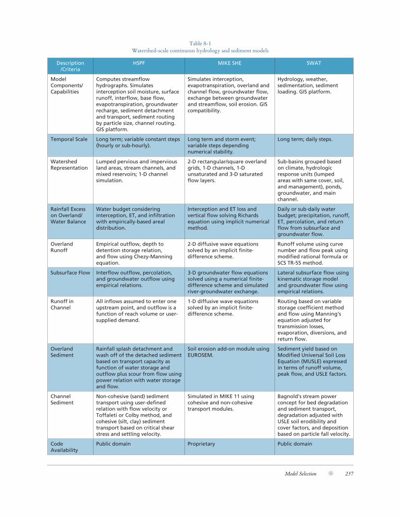
The capabilities of three of the hydrologic models that can be used to simulate pro-cesses in the Laguna Watershed are summarized below in Table 8-1.
Model Selection 237
Table 8-1 Watershed-scale continuous hydrology and sediment models
Description /Criteria
HSPF MIKE SHE SWAT
Model Components/ Capabilities
Computes streamflow hydrographs. Simulates interception soil moisture, surface runoff, interflow, base flow, evapotranspiration, groundwater recharge, sediment detachment and transport, sediment routing by particle size, channel routing. GIS platform.
Simulates interception, evapotranspiration, overland and channel flow, groundwater flow, exchange between groundwater and streamflow, soil erosion. GIS compatibility.
Hydrology, weather, sedimentation, sediment loading. GIS platform.
Temporal Scale Long term; variable constant steps (hourly or sub-hourly).
Long term and storm event; variable steps depending numerical stability.
Long term; daily steps.
Watershed Representation
Lumped pervious and impervious land areas, stream channels, and mixed reservoirs; 1-D channel simulation.
2-D rectangular/square overland grids, 1-D channels, 1-D unsaturated and 3-D saturated flow layers.
Sub-basins grouped based on climate, hydrologic response units (lumped areas with same cover, soil, and management), ponds, groundwater, and main channel.
Rainfall Excess on Overland/ Water Balance
Water budget considering interception, ET, and infiltration with empirically-based areal distribution.
Interception and ET loss and vertical flow solving Richards equation using implicit numerical method.
Daily or sub-daily water budget; precipitation, runoff, ET, percolation, and return flow from subsurface and groundwater flow.
Overland Runoff
Empirical outflow, depth to detention storage relation, and flow using Chezy-Manning equation.
2-D diffusive wave equations solved by an implicit finite- difference scheme.
Runoff volume using curve number and flow peak using modified rational formula or SCS TR-55 method.
Subsurface Flow Interflow outflow, percolation, and groundwater outflow using empirical relations.
3-D groundwater flow equations solved using a numerical finite-difference scheme and simulated river-groundwater exchange.
Lateral subsurface flow using kinematic storage model and groundwater flow using empirical relations.
Runoff in Channel
All inflows assumed to enter one upstream point, and outflow is a function of reach volume or user-supplied demand.
1-D diffusive wave equations solved by an implicit finite-difference scheme.
Routing based on variable storage coefficient method and flow using Manning’s equation adjusted for transmission losses, evaporation, diversions, and return flow.
Overland Sediment
Rainfall splash detachment and wash off of the detached sediment based on transport capacity as function of water storage and outflow plus scour from flow using power relation with water storage and flow.
Soil erosion add-on module using EUROSEM.
Sediment yield based on Modified Universal Soil Loss Equation (MUSLE) expressed in terms of runoff volume, peak flow, and USLE factors.
Channel Sediment
Non-cohesive (sand) sediment transport using user-defined relation with flow velocity or Toffaleti or Colby method, and cohesive (silt, clay) sediment transport based on critical shear stress and settling velocity.
Simulated in MIKE 11 using cohesive and non-cohesive transport modules.
Bagnold’s stream power concept for bed degradation and sediment transport, degradation adjusted with USLE soil erodibility and cover factors, and deposition based on particle fall velocity.
Code Availability
Public domain Proprietary Public domain
238 The Altered Laguna
Stream network models
The stream network is simulated to connect runoff generated by the land surface to down-stream areas of interest. The stream network models may be part of an integrated package with the upland watershed model, or a separate watershed model may be used to drive the stream model. To meet the flood analysis objective, the stream network model should be on the FEMA approved list; however, it is believed that a pairing of a non-FEMA upland model with a FEMA-approved channel model could be acceptable.
For the analysis of the flooding objective, HEC-HMS is the most commonly used hydrologic model that links the upland runoff generation and stream network transport. HEC-HMS is, however, most commonly used for storm event and not continuous simula-tion, as it lacks a detailed subsurface flow component. It also does not have capabilities for sediment and pollutant transport simulation.
The MIKE-SHE/ MIKE-11 pair also provide a unified simulation of watershed run-off and stream transport, and also integrate water quality components. From a technical perspective, these models appear suitable to meet all hydrologic, hydraulic, and sediment transport needs – although the modeling framework may be more complex than is needed. However, MIKE-SHE/ MIKE-11 are proprietary and do not meet the public domain cri-terion for TMDL development.
The SWMM model is capable of and approved for simulating channel hydrodynamics, but has only limited sediment transport capabilities. Further, as noted above, it is generally not appropriate for rural watersheds.
Neither HSPF nor SWAT is FEMA-approved. While the SWAT model is capable of sub-daily simulation of runoff, the channel routing is simplistic and pollutant transport in channels is constrained to a daily time step. As noted in the manual, “the model is not de-signed to simulate detailed single event flood routing.” HSPF can do full sub-daily routing of sediment and pollutants, but does not calculate detailed hydraulic routing. Rather, the hydraulic response of a stream channel is input through an externally specified “functional table” (FTab). In many applications, the FTabs are generated from HEC-HMS models, pro-viding a linkage between the two representations.
In terms of sediment transport, the better models use detailed hydraulic modeling to address the physics of sediment movement. The MIKE-11 component in MIKE SHE pro-vides this capability, though the other hydrologic models discussed above do not.
However, in the case of the Laguna, it may be appropriate to consider the nature of the key sediment volume-related management issues in selecting a modeling approach. We argue that the simulation requirements for sediment transport may be different for the por-tions of the tributaries upstream of the lower Laguna than for the lower Laguna main chan-nel itself. The Laguna’s sediment production zone lies primarily in the steep lands to the east of the Santa Rosa Plain. Simulation of sediment conditions in the steep zones may po-tentially be estimated by a simplified model or by empirical methods rather than attempting a detailed continuous simulation of both delivery to a channel and then transport under the rapidly varying hydraulic conditions. Given the substantial uncertainty associated with sediment transport modeling in general, development of greater detail in the steep reaches might be of limited utility. Transport of sediment from the upper watershed to the Laguna is most likely transport-limited: supply can generally be assumed to be available in excess of the transport capacity in the channels that cross the Santa Rosa Plain. For this reason,

Model Selection 239
use of a sediment transport capacity-based analysis system to evaluate depositional reaches and volumes, a fairly simple analysis requirement, may be entirely sufficient for analysis of sediment deposition and transport to the lower Laguna main channel. Options for this type of model model include simple spreadsheet models to evaluate sediment transport equa-tions appropriate to the conditions in the channels, or the US Army Corps of Engineers (USACE) SAM model, either stand-alone or as incorporated in the USACE 1D network hydrodynamic model, HEC-RAS.
Based on our understanding of surface water-groundwater linkages at this time, it is not clear how significant this interaction is to the key management questions identified for the Laguna, or what type of interaction of these elements is most important to represent. A limited number of full surface water-groundwater models exist; on the other hand, many watershed hydrology and some groundwater-specific models have limited representation of surface water – groundwater interactions. For these reasons, we have not recommended any particular modeling approach to modeling surface water – groundwater interactions at this time.
Receiving water models
The Laguna itself will require a different modeling approach from the upland streams. The Laguna has multiple channels, with significant storage capacity, and is also affected by back-water from the Russian River. A fully two-dimensional approach to hydraulics might be needed to fully resolve flood delineation issues.
Both the RMA and MIKE family of models are acceptable for FEMA purposes and can be used for both one-dimensional and two-dimensional simulation. If a full two-di-mensional simulation is needed, MIKE 21 of MIKE FLOOD would be needed rather than MIKE 11. The current RMA application is also one-dimensional, but could be expanded to two dimensions relatively easily.
At the lower Laguna main channel (perhaps from Stony Point Road downstream) and its connection to the Russian River, the hydrodynamics of the system become far more subtle and variable, and we recommend that sediment transport though this part of the sys-tem be addressed in the context of a more detailed hydrodynamic modeling tool. Options for this tool might include models that integrate the sediment transport component in the hydrodynamic model dynamically, such as MIKE 21C (curvilinear version of the 2D hy-drodynamic model from DHI Water and Environment), MIKE FLOOD (linked MIKE 11 – MIKE-21 floodplain analysis model), or a model that has a sequential sediment transport analysis tool such as RMA-2 with SED-2D. All of these hydrodynamic models meet the FEMA floodplain analysis acceptability requirement and are capable of modeling sediment erosion and depositional processes in a 2D environment. The RMA-2/SED-2D system cannot reflect change in hydraulic conditions in the system over time as a result of sediment deposition processes and requires use of a single representative grain size, but we do not consider either of these impediments as fatal flaws to its use for simulation of hydraulics or sediment transport processes in the lower Laguna de Santa Rosa. For example, the model could be run in a step-wise fashion to look at the effects of sediment deposition on hydrau-lics and sediment transport processes in the Laguna over time. In addition, it is probably not unreasonable to assume a single representative grain size for sediment processes in the

240 The Altered Laguna
Laguna. Either RMA-2, MIKE-21C, or MIKE FLOOD should provide a reasonable basis of analysis for ecosystem conditions.
8.5 Watershed and water quality models for TMDL
8.5.1 Model simulation requirements
The primary focus of the water quality model recommendations is the simulation of nu-trients, dissolved oxygen, and temperature for the purpose of TMDL development. The regulatory requirements for establishing TMDLs include some key elements of identifying the impairment, the pollutants, and the source categories or subcategories for load alloca-tions. Establishing TMDLs also requires consideration of seasonal variations so that water quality standards will be met during all seasons of the year. As suggested by the protocols for developing TMDLs established by U.S. EPA (EPA, 1999), key components of TMDL developments include source assessment, linkage between water quality targets and sourc-es, and load allocations. Watershed and water quality models can be useful in the TMDL processes for establishing the linkage between water quality targets and sources and for load allocation.
The impairments identified in the Laguna include nutrients, DO, temperature and sediments. The identified pollutants contributing to these impairments include nutrients (nitrogen and phosphorus), biochemical oxygen demand (or organic enrichment), and sediments. Therefore the minimum requirements for a watershed model are to be able to simulate different species of nitrogen (ammonia, nitrate, organic nitrogen) and phosphorus (dissolved and total), as well as transport dynamics of biochemical oxygen demand, DO, temperature and sediments. The source categories of pollutants identified for the water-shed include both point sources of wastewater discharge and various non-point sources that can originate from various land uses including urban, agricultural (e.g. pastures, vineyards, dairies) and rural areas (e.g. shrubs, grasslands, forests), as well as atmospheric deposition. Characterization of pollutant loadings from various sources is needed for establishing the linkage between sources and the resulted water quality. Therefore another requirement for the model is to be able to simulate loadings of various pollutants from various land uses (i.e. urban, agricultural, and rural areas). Pollutant loadings are largely associated with runoff and sediment transport, and therefore simulation of hydrology and sediments is also very important in pollutant loading estimates. The TMDL requirement for consideration of seasonal variations also requires the selected model(s) to be able to simulate continuously (and in shorter time steps, e.g. daily). An interpretation of the TMDL as a daily load is now required by court ruling, but does not necessarily require a daily-scale simulation. As some of the impairments such as temperature and DO that can vary during short period, sub-daily time steps may be ideal.
Besides addressing loadings from the watershed, the responses in water bodies to load-ings which can have significant impacts on achieving water quality standards can also be important. As suggested in the preliminary conceptual model (Section 5.1), the Laguna main channel is a slow-moving water body, which has large impacts on water quality. Low flow and channel geometry were believed to influence reaeration and water residence time which can impact dissolved oxygen level. Although a conceptual model on temperature

Model Selection 241
has not been developed, flow, channel geometry, and riparian vegetation should also have impacts on stream temperature, which is important for cold water fishery survival. There-fore, the model selection process also takes into account the response in receiving waters (in-stream processes). Minimum requirements for a receiving water model include simula-tion of flow, sediment transport, and algae/plant growth, DO dynamics and temperature for the TMDL purposes.
The three main categories of model evaluation criteria (i.e. hydrology and sediment, watershed processes, and in-stream processes) as well as the sub-categories as shown in the first two columns of Table 8-2 (see page 246–247) are listed below:
1. Hydrology and sediment – which can have significant impacts on pollutant loadings and transport
Time step – for evaluation of the extent of temporal variations accounted for by the model
Watershed segmentation – for evaluation of the extent of spatial variations accounted for by the model
Runoff – for evaluation of the mechanism of runoff generation
Groundwater – for evaluation of interaction of surface and groundwater and groundwater as a source of pollutant loadings
Sediment erosion and transport – for evaluation of sediment yield and transport as well as pollutants associated with sediments (e.g. phosphorus, BOD)
2. Watershed processes
Species of nitrogen simulated – for evaluation of the completeness of the species simulated
Pollutant loadings – for evaluation of pollutants originated from various sources including atmospheric deposition, urban/residential/agricultural runoff, septics, as well as from some agricultural practices such as fertilization and irrigation
Pollutant transport – for evaluation of phosphorus transport with sediments and terrestrial organic carbon/BOD sources
3. In-stream processes
Flow/sediment routing – for evaluation of in-stream channel routing and sediment transport
Plant/algae growth – for evaluation of algae/plant growth simulation that influences dissolved oxygen dynamics. Some processes of particular interests to Laguna include aquatic species simulated (whether it includes macrophytes) and releases of phosphorus bottom sediment
DO - for evaluation of simulations of DO diurnal cycle, DO source/sinks, BOD and SOD
Temperature – for evaluation of methods for water temperature calculation and whether effects of shading, flow and geometry are accounted

242 The Altered Laguna
Some other issues to consider in the model selection may include model availability (whether the model is in public domain), model data requirements (whether the model data require-ments can be met), model performance (whether reasonable calibration can be achieved) and model run time.
8.5.2 Watershed model evaluations
SWAT, SWMM, HSPF and WARMF
A few watershed models that address watershed pollutant loadings and in-stream responses, and are commonly used for TMDL applications, are evaluated here. These include several detailed watershed models that are available in the public domain such as SWAT, SWMM, HSPF (USEPA, 1997), and WARMF (Chen et al. 2001). All of these models are able to simulate the existing mixed land uses in the Laguna.
SWAT is a watershed model developed by USDA to simulate hydrologic, sedimentation, nutrient, and pesticide movement in large, complex rural watersheds and receiving water quality (Neitsch et al. 2002). It has particular strengths in simulating plant growth and management operations in agricultural land uses; however, the stream transport components are simplistic and operate only at a daily time step.
SWMM is a comprehensive watershed-scale model developed by EPA (Huber and Dickson, 1988) to address urban storm water runoff. Although SWMM was upgraded to simulate mixed land uses, it is mainly applied to address urban storm water issues.
HSPF is a comprehensive watershed and receiving water simulation package developed by EPA that simulates watershed hydrology, point and non-point loadings, and receiving water quality (Bicknell et al., 1993).
WARMF is a decision support system developed under the sponsorship from the Electric Power Research Institute (EPRI) for watershed management. Its Engineering Module is a GIS-based watershed model that simulates hydrology, pollutant loading and receiving water quality.
Both SWAT and HSPF are part of the EPA BASINS (Better Assessment Science Integrating Point and Nonpoint Sources) package designed to support watershed analysis and TMDL development. WARMF is currently compatible with BASINS, using BASINS to generate inputs. All the three models have been used in TMDL applications.
The SWMM model was eliminated from further consideration because it is generally not appropriate for simulation of rural watersheds. SWAT, HSPF and WARMF were com-pared for their capabilities in simulating hydrology and sediments, watershed processes for pollutant loadings and transport, and in-stream processes for simulating algal growth, dis-solved oxygen and temperature (Table 8-2). Overall HSPF offers finer temporal resolution and more detailed representation of in-stream processes. HSPF can be run on an hourly or shorter time step, which allows for more accurate simulation of time of concentration during flood events. An hourly time step also allows simulation of the DO diurnal cycle.

Model Selection 243
Although different algorithms are used, all three models have been reported to be able to simulate hydrology and sediment transport reasonably well in other applications (Borah and Bera, 2004; Chen et al. 2005). SWAT typically uses an empirical method (the curve number method) for simulating surface runoff and MUSLE method for simulating sedi-ment yield, which can lead to errors in certain types of soils and precipitation regimes. HSPF uses a storage-routing method for hydrology and simulates sediment as a result of accumulation, detach and transport. WARMF uses a more physically based approach for simulating runoff and simulates sediment as a result of rainfall and overland flow impact. Results from all three models are unreliable without a detailed calibration effort.
The three models also have similar capabilities for simulating pollutant loadings and transport from the watershed to streams, although processes are represented differently. All models are able to simulate pollutant loadings to waterbodies from atmospheric deposition, urban runoff, septics, fertilization and irrigation. In all models, the transport of phospho-rous can be simulated as a function related to sediment transport (required in SWAT and WARMF, optional in HSPF). In simulating organic nitrogen, SWAT simulates organic ni-trogen as active, stable and fresh pools. HSPF simulates both the labile and refractory par-ticulate and dissolved organic nitrogen. Although included in the TKN and TN simulation, organic nitrogen is not currently explicitly tracked in WARMF. In terms of simulating ter-restrial sources of organic carbon/BOD, SWAT simulates BOD as a function of sediment loading. HSPF can simulates both particulate organic carbon, potentially as a function of sediment, and dissolved phase loading. WARMF simulates organic carbon from direct sur-face loadings as well as particulate and dissolved organic carbon as a result of litter decay. In general, SWAT is preferable for conducting detailed simulations of agricultural practices, while HSPF provides a more comprehensive and flexible representation of pollutant load-ing and transport. The two models can be combined, or SWAT agronomic simulations can be used to fine tune an HSPF watershed model.
The receiving water transport portions of the three models all use one-dimensional completely mixed segments. An important distinction is that SWAT simulates instream transport only at a daily time step, preventing detailed resolution of kinetics. Both SWAT and WARMF simulate stream water temperature as a function of ambient air temperature and can provide poor results for thermal simulations. HSPF uses a more sophisticated algo-rithm to calculate in-stream temperature based on heat balance from meteorological data, shading, boundary condition, flow, water body geometry and inflow temperature
All three models meet the general requirements for simulating hydrology, sediments, and terrestrial loadings of pollutants of the Laguna watershed. However, the in-stream processes of SWAT and WARMF are much less sophisticated than HSPF.
The data requirements for the three models are similar in some aspects. All of the mod-els require meteorological and hydrologic data, land use distribution and characteristics, and receiving water characteristics. The SWAT model always uses soil data as input, while this is optional for HSPF. Generally the SWAT model has less data requirements and calibra-tion needs. If HSPF is run on an hourly time step, hourly meteorological data is required. Limitations of the models have also been reported. For example, SWAT has been reported to perform better on monthly bases than shorter time steps in previous applications (Bo-rah and Bera, 2004). HSPF has been reported to be more difficult to calibrate due to more data requirements (Borah and Bera, 2004). WARMF also has more data/parameterization requirements for calibration.

244 The Altered Laguna
At the third TAG meeting, several models (i.e. WEND, GEM, and MIKE-SHE) were suggested by TAG members as models of interests for further evaluation and therefore an evaluation of each of these three models for suitability of TMDLs was summarized be-low:
WEND
Watershed Ecosystem Nutrient Dynamics (WEND) is a dynamic model that was developed by the Natural Resources Conservation Service in conjunction with the University of Ver-mont to model phosphorus in watersheds (Cassell et al. 2001). The model is based on a mass balance approach to track input and output of phosphorus through agriculture, forest and urban sectors. The model has the advantage of having a detailed representation of process-es that influence phosphorus dynamics in poultry and vegetable farms (e.g. chicken litter, feed, irrigation, fertilizer, harvest, manure, atmospheric deposition). However, the model is mainly a phosphorus mass balance model and lacks functionalities to simulate hydrology and nitrogen cycles, which are considered to be the key components in nutrient and DO TMDL development. Information on how model represents phosphorus processes in urban and forest sectors is also lacking. The model so far has been applied to four watersheds in the US, all of which have animal feeding operations. Despite of its advantage in represent-ing phosphorus dynamics in farms in great detail, the model is not sufficient enough for a full simulation of hydrology, sediment transport, and nitrogen and carbon loadings from watersheds and therefore does not meet the needs for TMDL development.
GEM
The General Ecosystem Model (GEM) is an ecosystem model designed to simulate the re-sponse of algal and macrophytes communities to the simulated levels of nutrients, water and environmental inputs within different ecosystems (e.g. wetland, terrestrial; Fitz et al. 1996). The model includes processes considered to be most important in influencing plant production and ecosystem properties. The model assumes hydrology as the critical process in controlling plant growth and nutrient cycling, with hydrology, plant production and nutrient cycling being the key components of the model. The model is spatially homo-geneous (or cell based). Scaling up to landscape will require the model to be incorporated into other spatially distributed models. One advantage of the model is that it does include hydrology, nutrient cycling and dynamics of both algae and macrophytes. However the model is only a cell model or a single ecosystem type model with very simplified represen-tation of processes, and therefore is most suitable for hypothesis testing for long-term eco-system responses. It does not account for pollutant loadings from non-vegetated areas (e.g. urban areas) nor is it spatially distributed to account for the spatial variation existing in the watershed. The model also lacks representation of detailed in-stream processes. Currently the model is still under testing for simulations in different ecosystem types. And a spatially distributed version is not readily available for use. Therefore the use of GEM for TMDL purpose is not appropriate in its current form.
Model Selection 245
MIKE-SHE
MIKE-SHE is a spatially distributed and physical based modeling system for hydrology and pollutant simulation, developed by Danish Hydrology Institute (DHI; Refsgaard and Storm, 1995; Abbott et al. 1986). The model simulates full hydrological cycle of inter-ception/ evapotranspiration (ET), overland and channel flow (OC), unsaturated zone and saturated zone flow, snowmelt, and exchange between groundwater and surface water. The model has a detailed representation of groundwater component (3-D grids) and spatially distributed overland and unsaturated zone flow (1-D grid cells). The model simulates both event and long-term hydrological response. The temporal scale of the model simulation is flexible and can range from minutes to days. Besides hydrology, the model has several add-on modules that can be used to simulate advection and dispersion of solutes, geochemical processes, crop growth and nitrogen processes in the root zone, soil erosion, and irrigation. MIKE-SHE has been widely applied in Europe for groundwater pollution, flood forecast-ing and leaching of nitrogen from agricultural lands. MIKE-SHE was coupled to DAISY (Hansen et al. 1990) model to simulated crop production and water and nutrient dynamics in the root zone.
MIKE-SHE is the only model that fully integrates groundwater and surface water sim-ulations and is able to simulate the groundwater and surface water interaction. The nitrogen simulated by DAISY primarily focuses on nitrate only. There is not enough information regarding the functionality of the model to simulate in-stream water quality processes (e.g. DO, temperature). The spatially distributed model also requires extensive data input, for many cases only limited existing information is available. The main limitation of MIKE-SHE is that it is not public domain and the availability of the code is questionable.
8.5.3 Water quality model of the Laguna
None of these watershed models is optimal for simulating responses in the Laguna itself, with its complex, slow-moving hydrology and important interactions with sediment and macrophytes. The receiving water portion of the HSPF model could be applied to the Laguna, except under conditions of reversing flows, and would meet many of the require-ments for the study. SWAT and WARMF are inadequate for simulation of the Laguna itself and would need to be linked to a more detailed receiving water quality model if used for watershed simulation. A variety of additional receiving water quality models are available that could simulate responses of the Laguna at different levels of detail, each with their own specific advantages and disadvantages (USEPA, 1997; Table 8-2). Among these, CE-UAL-W2 and RMA-11 may be good candidates at a moderately high level of sophistica-tion. WASP model is also a detailed model developed by EPA. However, the temperature and sediment routine in WASP is less sophisticate for TMDL purposes. Previous attempts to apply CE-UAL-W2 to the Laguna by City of Santa Rosa suggested problems in mass conservation among the reaches and problems with applying a reservoir model to streams.

246 The Altered Laguna
Table 8-2 Comparison of watershed model functionalities
CategoryLaguna
Model Needs SWAT HSPF WARMF
Hydrology and Sediment
Time Step Daily or subdaily on land surface; daily only in waterbodies
Daily, hourly, subhourly Daily
Watershed segmentation
Subbasin / HRU (multiple subbasins)
Subbasin / HRU Subbasin
Runoff Surface runoff simulated using curve number method or Green-Ampt infiltration method; other flow components include bypass and lateral flow
Philip infiltration with full simulation of interflow and groundwater
Runoff from soil layers is simulated based on soil moisture, soil saturation and field capacity, soil thickness and hydraulic conductivity
Groundwater Shallow, deep (as sink) Shallow, deep (as sink) Shallow
Sediment erosion and transport
MUSLE, erosion/sediment as a function of rainfall/runoff
Accumulation and detachment based on Negev model and comparable to USLE; transport limited by flow capacity
Sediment erosion from rainfall and overland flow. Simulate sand, silt and clay separately. Transport limited by transport capacity
Water quality- processes
Nitrogen NH4, NO3, ON (active, stable, fresh)
NH4, absorbed NH4, NO3, labile and refractory PON and DON
NH4, NO3, TKN, TN; ON not explicitly tracked
a. pollutant sources
Atmospheric deposition
Wet only Wet and dry (time-series, monthly)
Wet and dry (time series)
Urban / residential
Build-up/wash off or USGS regression equations
Impervious runoff, build-up/wash off
Surface loading, impervious runoff
Septic Systems
Not explicit: Either as point source or as fertilization rate
Not explicit: Either as point source or loads applied to land surface
Total septic flow volume of each catchment is applied to a specific soil layer
Point Sources Partial (no BOD or temperature)
Full flexibility Full flexibility
b. operations/BMPs
Fertilization User specified amount of fertilizer applied/auto-fertilization
Application rates/loads Monthly loading rates applied to different land uses, routed through soil
Irrigation User scheduled or auto application
Multiple options (including time series)
Time series of flow added to specific land use of the catchment
Filter strips Trapping efficiency calculated as a function of width
Removal efficiency (constant/vary monthly), various width
Model as a rectangular catchment with user specified slope, length and width
c. pollutant transport
Phosphorus transport with sediment
Loading function, proportional to sediment
Use a potency factor to relate to sediment or simulate independently via buildup/washoff
Partition coefficient, related to sediment
Terrestrial organic carbon/BOD source
Function of sediment loading and plant growth/soil organic carbon simulation
Potency factor, surface built-up/wash-off, subsurface concentration for dissolved phase
Product of litter decay, surface loading
Water Quality- In-stream processes
Dimension 1D, completely mixed (daily)
1D, completely mixed (sub-daily)
1D,completely mixed (daily)

Model Selection 247
CategoryLaguna
Model Needs SWAT HSPF WARMF
a. Flow/sediment routing
In-stream sediment transport
Deposition/degradation, related to max velocity
Deposition /scour, based on shear stress. Sand, silt, and clay
Deposition/scour, based on shear stress. Sand, silt, and clay.
Bank stability Channel erodibility factor As a function of bed erosion based on shear stress
Bank erosion (a stability factor)
b. Algae growth
Aquatic species
Algae, macrophytes not simulated
Benthic algae, phytoplankton, zooplankton, no macrophytes
Phytoplankton (green, blue-green, diatom), periphyton, no macrophytes
Algal growth Affected by temperature, nutrient, light (self shading) – limited by daily time step
Affected by temperature, nutrients, light (turbidity/self-shading))
Affected by temperature, nutrient, light extinction (function of suspended sediments, detritus and algal biomass)
Release of phosphorus from bottom sediment
Not available Benthic release under aerobic and anaerobic condition
Not available
c. DO DO diurnal cycle
Not available Full simulation Not available
DO source/sinks
CBOD decay, nitrification, SOD, reaeration, algae photosynthesis/respiration
CBOD decay, nitrification, SOD, reaeration, photosynthesis/respiration
Reaeration, algal photosynthesis/respiration, DOC decay, SOD, nitrification
Biochemical Oxygen Demand (BOD)
CBOD modified by deoxygenation and settling
CBOD, Benthic release of BOD, benthic algae death, zooplankton, phytoplankton death, decay, settling
BOD as a result of organic carbon decay, BOD decay
Sediment Oxygen Demand (SOD)
Constant Constant or exponential function of DO. Benthic release of BOD under low oxygen/anoxic condition
Reach-specific constant (user input)
d. Temperature
Water temperature
Function of air temperature
Heat balance based on meteorological data, area of water exposed to radiation (shade), boundary condition, hydrodynamic (flows and water body geometry), and inflow temperature.
Function of inflow temperature and air temperature
Shading/light extinction
Temperature not affected by shading
Shading due to riparian cover is accounted for and will impact in-stream temperature
Shading due to riparian vegetation is not considered and will not impact temperature
Other considerations
Availability Public – code available Public – code available Public, some limitations on code
User-interface User-friendly User-friendly Most user-friendly
TMDL Applications
Moderate number Most frequently used Limited number

248 The Altered Laguna
Table 8-3 Receiving water quality models
Model Organization Water Body Time Scale
Dimension Pollutants Summary
AQUATOX USEPA Reservoir/Lake, Stream
Dynamic 1-D Sediments, Nutrients, Toxic Substances, BOD/DO
Predicts the fate of various pollutants, such as nutrients and organic chemicals, and their effects on the ecosystem, including fish, invertebrates, and aquatic plants.
BATHTUB USACE Reservoir/Lake
Steady state
1-D Nutrients Steady state model that simulates nutrient mass loading and algal response in lakes and reservoirs
CE-QUAL-W2
USACE Reservoir/Lake, Stream, Estuary
Dynamic 2-D Nutrients, BOD/DO, Bacteria
A two-dimensional, laterally averaged, hydrodynamic and water quality model.
EFDC EPA & Tetra Tech, Inc.
Reservoir/Lake, Stream, Estuary
Dynamic 1, 2, 3-D Sediments, Nutrients, Toxic substances, Metals, BOD/DO, Bacteria
State of the art hydrodynamic model that can be used to simulate aquatic systems in one, two, and three dimensions
QUAL2K Steve Chapra, USEPA TMDL Toolbox
Streams/River Dynamic 1-D Nutrients, BOD/DO, Bacteria
River and stream water quality model that simulates conventional constituents
RMA-11 USACE Estuaries, bays, lakes, and rivers
Dynamic/ Static
3-D Nutrients, BOD/DO, algae, sediments
Finite element water quality model for simulation of three-dimensional estuaries, bays, lakes and rivers.
WASP USEPA Reservoir/Lake, Stream, Estuary
Dynamic 1, 2, quasi-3-D
Sediments, Nutrients, Toxic substances, Metals, BOD/DO, Bacteria
A dynamic model for aquatic systems, including both the water column and the underlying benthos that simulates pollutants dynamics in 1, 2, and 3 dimensions.
All of these models lack the capability to simulate overbank access to the floodplain and macrophyte (i.e. Ludwigia) growth, which can have significant impacts on water quality. Currently there are models available for submerged aquatic species in some of the water quality models (e.g. CE-UAL-ICM). However, Ludwigia is an emergent aquatic species, and development of new model routines may be needed for full simulation. A full analysis of model requirements in light of information needs for management and decision needs to be carried out before final selection of modeling tools for the Laguna.