Embed Size (px)
Citation preview

Mobile GIS Transforms Operations at
St. Johns County Utilities St. Johns County Utilities is using technology that transforms how they manage and
provide water, waste water, and reuse water to 100,000 customers in NE Florida. Implementing these tools will help us keep high customer satisfaction, water quality and cost effectiveness, while facing new challenges from high growth, development, aging infrastructure, and new regulations.
This presentation illustrates the implementation, improved management and savings through our Cityworks enterprise asset management system, Mobile Technology, ArcGIS Online, ArcGIS for Water Utilities Emergency Response,
Hydraulic Modeling, Data Reviewer and Fleet Management AVL system.
Download at: http://sjcutilities.maps.arcgis.com
St. Johns County Utility Department, Cityworks 2014 Exemplary UserTom Tibbitts, [email protected]
August 2016

St. Johns County Utilities2
Water, Wastewater, Reclaim Services
42,000 Accounts & 100,000 Customers
8 Water Treatment Plants (27 mgd)
11 Wastewater Treatment Plants (14 mgd)
13 Storage Tanks & 336 Pump Stations
1,350 miles of Distribution & Collection Mains

St. Johns County Utilities3
Agency Values: Water Quality
Cost Effectiveness
Customer Satisfaction
Operational Impacts: High Growth Rate
Expansion
Consolidation
New Regulations
Aging Infrastructure
The Challenge: Aging infrastructure, fast-changing population patterns, changing technologies, plus the increased demand for reliable and efficient systems are
driving greater investments in infrastructure.

4
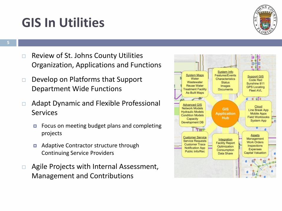
GIS In Utilities
Vision for GIS Technology Solutions Follows
Industry Techniques and Emerging Principals
GIS In Utilities
Review of St. Johns County Utilities Organization, Applications and Functions
Develop on Platforms that Support Department Wide Functions
Adapt Dynamic and Flexible Professional Services
Focus on meeting budget plans and completing projects
Adaptive Contractor structure through Continuing Service Providers
Agile Projects with Internal Assessment, Management and Contributions
5

Cityworks Enterprise Asset Management System
Criticality Assessment and Capital Planning
ArcGIS Online
ArcGIS for Water Utilities Emergency Response
Hydraulic modeling
GIS Data Quality and Workflow
Fleet Management and Logistics
Mobile GIS & Technology Solutions
The Challenge: Aging infrastructure, fast-changing population patterns, changing technologies, plus the increased demand for reliable and efficient systems are driving greater investments in infrastructure.

Enterprise Asset Management
Objectives:
Improve preventative maintenance
Extend life of assets
Reduce asset downtime
Lower total cost of ownership
Improve service
Better accounting
Better budgeting

Cityworks Asset Management System
GIS Asset Database
Spatial Assets
Ve
rtic
al A
sse
ts
Implementation:
Service Request - Call CenterRecording problems, logging customer calls
Manage, dispatch investigations, record findings
Create work orders as needed
Work Order ManagementJob codes with work flow
Preventive and Reactive maintenance
Cost summaries and history
Inspections – Condition AssessmentsMaintenance Scoring & Condition Scoring
Asset Analysis
Resource and Equipment ManagementLabor, Material, Equipment
Storeroom and Inventory management
Reporting and ManagementReporting, Dashboards, KPI’s

Asset Management - Service Requests
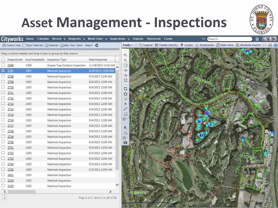
Asset Management - Inspections

Asset Management - Inspections

Work Orders - Details
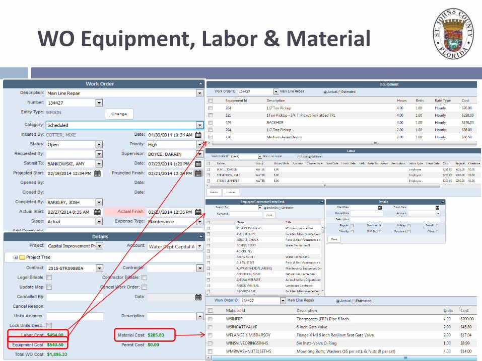
WO Equipment, Labor & Material

Asset Management - Warehouse & Inventory
Storeroom Solution
GL Budget Codes
Monthly Balance Reports
Storeroom Inventories
Match to 10%
14

Cityworks AMS - Mobile
Field Crews use Toughbooks & WiFi
Plants use dedicated PCs
Pretreatment Uses Win Tablet

Asset Management – Operational Awareness
16
Organizational Awareness
Comprehensive View
Operational & Financial
Monthly Activity Reports
Work Order, Asset, Cityworks
Management, Data QC, etc.
Over 60 Report Templates

Asset Management - Benefits & Impact
Improved Awareness of Assets, Operations and Functions
Real-Time Access Throughout the Organization
Employees are empowered and motivated
Improved Efficiency and Productivity
True Cost Tracking for Maintenance, Expenses and Planning
Better Tracking of Performance Measures
Improved customer service, with tracking and shorter response times
Work Orders: 12,362 last twelve months from 588 templates
Call Center Service Requests: 1,341 last twelve months

INTEGRATED DATAFLOW
Customer Information System
Customer IS Integration
• Update new or retired Accounts in Cityworks
• Update new or retired meters in GIS
• Reconcile w/ Sensus meter locations
• Latest Customer Info
Meter (AMR) Integration
• Consumption Analysis • Support Conservation• Trigger WO based on Status• SJRWMD Cost-Share

19
Criticality Assessment
Objectives:
Aging Infrastructure requires capital rehabilitation and reinvestment strategies.
Establish Data, Criteria, and Decision Matrix
Identify a Criticality Score = LoF+ CoF
Likelihood of Failure is impacted by age, material, work order history, impact from force mains, etc
Consequence of Failure is impacted by customer density, service network, critical facilities, environmental proximity, etc
Integrate with Cityworks Tools and Data

Criticality Assessment - Assets
The Ponte Vedra Service Area acquired two commercial utilities in 2005-2007 to stabilized the utility services and unified the infrastructure.
Aging infrastructure requires capital rehabilitation to provide safe and reliable service.
143 miles of water transmission and distribution mains, with 2,262 valves.
101 miles of gravity sewer mains and 46 miles of sewer force mains.
2,749 manholes
20

Criticality Assessment - Data21
Geodatabases and databases for Water Mains and Sewer Mains and Manholes, including diameter, material, age, type…
Cityworks data including Preventative Maintenance, Repair History, Inspection Scores, Maintenance Scores, Line Breaks and Capital Rehabilitation.
Network and Spatial Analysis for flow,downstream relationships, customer density, etc
GIS Data including identification of critical facilities, pavement, wetlands, Sanitary Sewer Overflows.

Criticality Assessment - Analysis22
Criticality Analysis is performed through GeoProcessing models and scripts
Uses custom scoring and weighting.
Each Asset has a Criticality Score.
Likelihood of Failure
Consequence of Failure
Criticality Scores can be reviewed and analyzed geographically, or in tables.
A summary report, and integrated GIS Data provide format for scalable review and executive summaries.
23
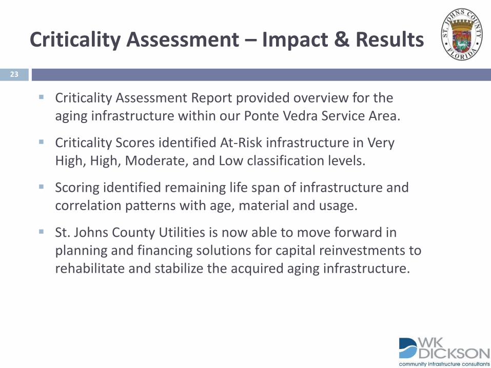
Criticality Assessment – Impact & Results
Criticality Assessment Report provided overview for the aging infrastructure within our Ponte Vedra Service Area.
Criticality Scores identified At-Risk infrastructure in Very High, High, Moderate, and Low classification levels.
Scoring identified remaining life span of infrastructure and correlation patterns with age, material and usage.
St. Johns County Utilities is now able to move forward in planning and financing solutions for capital reinvestments to rehabilitate and stabilize the acquired aging infrastructure.

INTEGRATED WORKFLOW
Asset Management & Capital Rehabilitation

25
Mobility - ArcGIS Online Platform
Objective:
Increase Response Time
Enable Collaboration
Respond to Immediate Needs
Expand Customer Service
Improve Field Collection
Implementation:
ArcGIS Online & ArcGIS Server

26
ArcGIS Online - Applications

27
ArcGIS Online - Applications
Capital Improvement Projects
Key Improvements Story Map
CIP Map - App Builder
Purpose:
Improve customer awareness of capital spending and needs.
Provide central source for CIP status for internal and partner awareness.

28
ArcGIS Online - Applications
Tower Site Analysis
Tower Site - App Builder
Purpose:
Analysis of Tower Locations.
Compare locations of towers, expected growth, expansion.
Share easily with Contractor for analysis and to readily collaborate with staff.

29
ArcGIS Online - Applications
Customer Service
Water Quality, Service Areas, Advisories, Irrigation Rules…
Customer Service - App
Purpose:
Make valuable customer service information readily available for customers.
Use expanding application and mobile endpoints.

30
ArcGIS Online - Applications
Project Status
Smoke Testing
Sewer Conversion
Purpose:
Make project status and detail information readily available to customers and partners.
Improve customer service and experience during public sensitive maintenance and capital improvements.

31
ArcGIS Online - Applications
Utility System Map
App Builder
Explorer for Mobile
Purpose:
Expand interface to system maps along with Cityworks.
Provide quick access to maps, in additional environments.
Expand system maps to business partners and agencies.

INTEGRATED WORKFLOW
I&I Prevention and Smoke Testing
Find It & Fix ItCityworks WO on the Fly
County MaintenancePrivate Repairs
Less Reporting & More Repairing
Asset ManagementEliminated age and maintenance issues.
GIS Analysis Eliminated Likely Sources of Cross-Connection
and supported analysis of SCADA values.
Mobile NoticeAdaptive Public NoticeOperational Awareness Contract Collaboration SJSO & FD Awareness

33
ArcGIS for Water Utilities Emergency Response
Objective:
Improve Line Break Response
Improve Customer Advisory
Reduce Steps
Improve Capability
Implementation:
Line Break Identification
Network Tracing
Advisory Publishing

34
AG4H20ER – Line Break Response
Line Break Response
Collector App to Identify Break
SJC Utilities – Integration with Cityworks Service Request
Network & Valve Trace
Finds Valves. Options for barriers and valve bypassing
Isolation/Outage Area
Selects and Summarizes Impacted Meters, Hydrants and Valves. Saves to Service for Response and Public Advisories
35
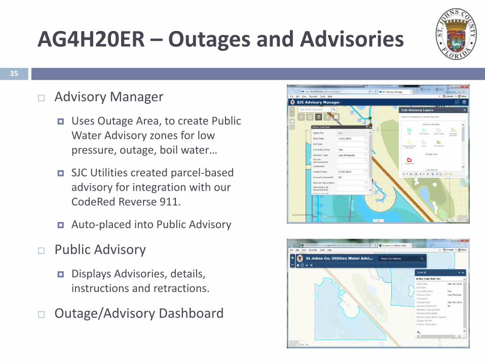
AG4H20ER – Outages and Advisories
Advisory Manager
Uses Outage Area, to create Public Water Advisory zones for low pressure, outage, boil water…
SJC Utilities created parcel-based advisory for integration with our CodeRed Reverse 911.
Auto-placed into Public Advisory
Public Advisory
Displays Advisories, details, instructions and retractions.
Outage/Advisory Dashboard

Scalable
Flexible
COTS & Customizable
Sustainable
Cost-Effective
Integration
36
ArcGIS Online - Platform

Objective:
Better understanding of hydraulic systems and information readily available for review and analysis.
Implementation:
Integration with ArcGIS, run in house, using Innovyze InfoWater.
Engineering Division coordination with a vendor to create models and use parameters to serve growing need. GIS Data provided support and data requirements including direct ArcGIS integration.
County’s high growth rate requires revision procedures and tools.
37
Hydraulic Modeling
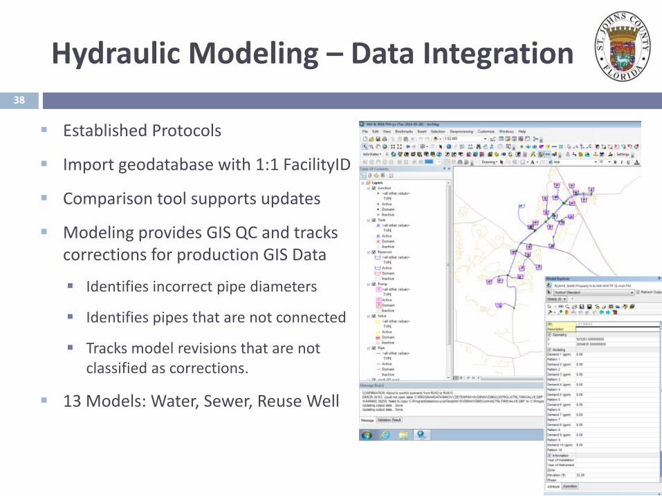
Established Protocols
Import geodatabase with 1:1 FacilityID
Comparison tool supports updates
Modeling provides GIS QC and tracks corrections for production GIS Data
Identifies incorrect pipe diameters
Identifies pipes that are not connected
Tracks model revisions that are not classified as corrections.
13 Models: Water, Sewer, Reuse Well
38
Hydraulic Modeling – Data Integration

“Can we shut down the Innlet Beach Water Treatment Plant for 2 weeks during the low flow months, interconnect the 2 Ponte Vedra water systems, and meet fire flows across both systems”
“What pressure do we need to set the VFD set point to when we start up the NW WWTP Reuse pumps to allow Turnbull to flow at 300 gpm. How does this change if we open the valve to fill the NW MLS Tank?”
“What pumps in the Northwest area need to be upgraded when they are redirected to the NW WWTP headworks?”
“Can we reroute the Innlet Beach WWTP to the Players Club WWTP using and of the existing piping and what pump station upgrades would be necessary”
“What pipe size do we need to install through the CR207 corridor to improve the high pressures near the CR214 WTP”
39
Hydraulic Modeling – Case Studies

GIS Data Quality and Workflow
Objective
Improve GIS data standards to support ancillary applications
Improve Editing Workflows, and Data Reviewing timeframes
Reduce response time by having quality data prior to requests
Implementation
Professional Services to utilize industry experience and expedite implementation and support staff’s development.
Utilize Existing Tools and Standards
Utilize Data Reviewer, Attribute Assistant & Water Utility Editing Toolbar
Evaluate Workflow Manager & Task Manager
40

Data Reviewer identifies geometry errors and data missing from attribute tables.
It selects & zooms to each record found by rule.
Can select from selection, extent, or database.
Batch jobs can run many rules all at once.
GIS Data Quality – Data Reviewer
Data Reviewer CheckConfigured to layer and the length of unacceptable lines

Attribute Assistant – Series of rules and behavior for editing features.
Top row, without Attribute Assistant, has little information.
The second row, with attribute assistant, has many fields auto-filled.
The Facility ID is a unique value auto-populated
Year field is auto-filled from the Install Date field (set in the template)
The Diameter fields pull from a separate layer (the pressurized mains)
The third row’s highlighted values self-perpetuate from previous entry.
Connectivity rules require a feature be placed correctly
Tap fitting has 1 connection, and cannot be placed with multiple diameters
GIS Data Quality – Attribute Assistant

Customized using a configuration file
Provides several tools
Add Laterals at Connections Example
Single Click adds the water meter, service line, sampling station and tap, and joins to the water main
Custom settings through configuration files. For example, the distance from the sampling station to the tap can be set as a static distance or as a percentage of the total line length, and also when creating manholes with cleanouts, or join to the Main at a different angle, etc.
GIS Data Quality- Water Utility Editing Toolbar

Objectives:
Improve Operational Awareness
Awareness of Fuel Consumption
Improve Field Management
Reduce Maintenance Time
Integration with WO Fields
Implementation:
CompassCom product
Fleet-wide use
44
Fleet Management and Logistics

St. Johns County Utilities is implementing successful strategies to help solve our challenges.
Focus towards Water Utility Business Patterns has proven very effective and products serve the wider range of needs.
ArcGIS and Cityworks Platforms provide adaptive solutions.
Professional Services supports wider options and expediency.
The needs of the Utility are dynamic and evolving. Solutions that address these needs, through established resources, helps effective responses, reaction times, and predictive solutions.
45
Conclusion - Mobile GIS & Technology Solutions