Embed Size (px)
Citation preview
Mobile Applications Aiding the Visually Impairedin Travelling with Public Transport
Piotr Korbel, Piotr Skulimowski, Piotr Wasilewski and Piotr WawrzyniakInstitute of Electronics
Lodz University of Technology
ul. Wólczanska 211/215, 90-924 Łódz, Poland
Email: {piotr.korbel, piotr.skulimowski}@p.lodz.pl
Abstract—The paper presents a set of mobile applicationsaiding the visually impaired in using the public transport. Auser equipped with a modern smartphone with mobile datatransmission and positioning capabilities can access locationrelated context information. Keeping up the connection withdedicated system servers gives the user access to additionalservices, e.g. enables the use of passenger information systemand provides access to services facilitating the navigation inurban areas. The paper describes an overall architecture ofthe system for guidance and public transport assistance of thevisually impaired. Then, the details of the applications developedfor Android based smartphones are presented. The applicationsare mainly focused on aiding in urban navigation and providevarious ways of accessing data from public transport passengerinformation system.
Index Terms—Context-aware services, mobile computing, per-sonal communication networks, pervasive computing, radio nav-igation
I. INTRODUCTION
ACCORDING to the World Health Organization there
were more than 285 million visually impaired living
in the world in 2012 [1]. Even moderate vision impairment
may strongly affect their everyday activities and often leads
to social exclusion. Inability to sense the surrounding environ-
ment, poor orientation and navigation capabilities, difficulties
in accessing textual information result in a limited mobility
of the blind and the visually impaired [2]. Travelling becomes
especially challenging in urban areas. Lack of good spatial
orientation makes difficult to find a safe path among obstacles,
and to locate and identify points of interest (POI) like bus
stops or pedestrian crossings. Inability to access textual infor-
mation like street name, public transport timetables, numbers
of vehicles gives rise to additional difficulties. Recently, a
number of electronic travel aids (ETA) addressing the needs
of the visually impaired have been developed. The devices
are used to overcome difficulties associated with everyday
activities, i.e. problems with spatial and geographical ori-
entation, navigation, accessing visual information. Electronic
systems aid the visually impaired in mobility and in ac-
cessing various public services. One of the applications of
the electronic aids is to facilitate access to public transport
services. Precise information on user location can be used to
This work was partially supported by the National Centre for Research andDevelopment of Poland under grant no. NR-02 0083-10 in years 2010-2013.
retrieve position related data from public transport passenger
information systems, e.g. bus or tram arrival times, information
on routes, temporary changes to the timetables, etc. A number
of electronic systems aiding the visually impaired in urban
travelling involve various beaconing techniques to identify
landmarks like bus or tram stops, entrances to public buildings,
etc. [3][4][5][6][7]. Transmitters installed in the landmarks
send signals uniquely identifying the place. System informa-
tion can then be decoded with the use of a dedicated handheld
receiver and presented to the user as voice messages. Another
approach to guidance of the blind involves the use of dedicated
user terminals equipped with GPS receiver, GSM transceiver
and inertial sensors [8][9]. With the growth of popularity of
advanced mobile phone terminals, more and more smartphone
applications aiding the visually impaired in navigation and
travelling appear on the market [10][11][12]. Some of them,
like OnTheBus project [10], address also the problem of
public transport accessibility. Significant number of various
ETAs have been developed so far trying to solve different
mobility difficulties. However, many of the assistive devices
and applications address only selected aspects of the mobility
problems, and hence have not gained wider acceptance of their
target group of users so far. Therefore, there is still a pursuing
need to develop complex solutions aiding the visually impaired
in mobility as well as aiding other groups of users in travelling
in urban environment.
II. SYSTEM FOR GUIDANCE AND PUBLIC TRANSPORT
ASSISTANCE
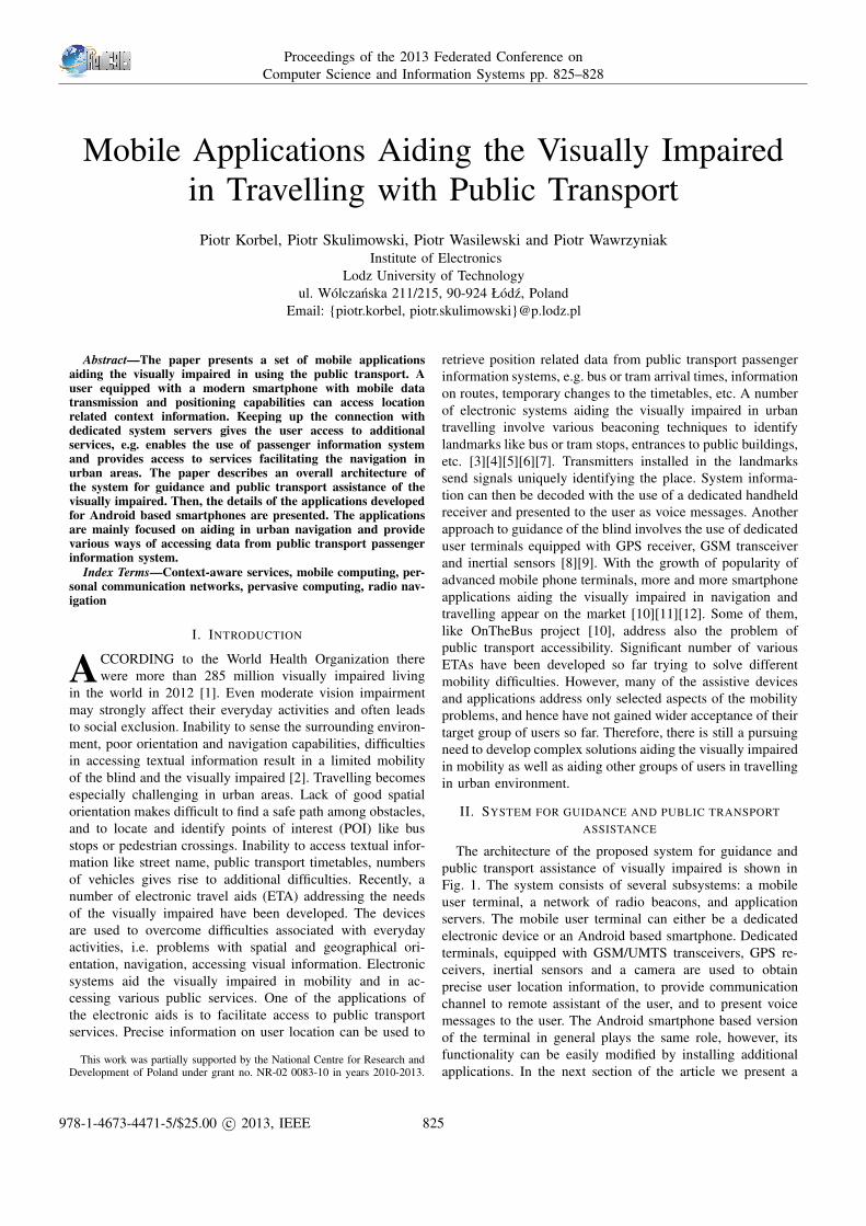
The architecture of the proposed system for guidance and
public transport assistance of visually impaired is shown in
Fig. 1. The system consists of several subsystems: a mobile
user terminal, a network of radio beacons, and application
servers. The mobile user terminal can either be a dedicated
electronic device or an Android based smartphone. Dedicated
terminals, equipped with GSM/UMTS transceivers, GPS re-
ceivers, inertial sensors and a camera are used to obtain
precise user location information, to provide communication
channel to remote assistant of the user, and to present voice
messages to the user. The Android smartphone based version
of the terminal in general plays the same role, however, its
functionality can be easily modified by installing additional
applications. In the next section of the article we present a
Proceedings of the 2013 Federated Conference on
Computer Science and Information Systems pp. 825–828
978-1-4673-4471-5/$25.00 c© 2013, IEEE 825
Fig. 1. Architecture of the electronic system for guidance of the visuallyimpaired in urban environment.
set of mobile phone applications aiding in urban navigation
and public transport accessibility. The network of low power
and low range radio transmitters is used to provide precise
information on actual location of the user and to facilitate
access to position related data, e.g. a timetable of vehicles
arriving at the bus or tram stop [13]. The servers of the
system store public transport passenger information data and
points of interest databases, as well as expose services enabling
communications between all of the system components.
A. Passenger Information System
Currently a lot of cities operate real-time public transport
management systems (PTMS). Such systems help transport
company to increase the efficiency of running vehicles, reduce
travel times and/or improve the punctuality, especially when
PTMS is integrated with traffic lights management system.
Very often PTMSs include passenger information subsystem
(PIS) providing information about estimated arrivals and/or
departure times as well as travel times. Usually such data are
displayed on dedicated signs located within bus stops. How-
ever such approach is very useful for almost all passengers
it is completely useless for blind and semi blind people for
obvious reasons. Similar system is operated in Lodz, Poland
by municipal transportation company MPK. Lodz is mid-size
city in central Poland of the area 300 km2 with more than
700000 inhabitants. MPK operates about 200 trams and 400
buses serving almost 100 routes. Trams and buses fleet is
managed by RAPID system delivered by Sigtec, Australia
integrated with adaptive traffic system SCATS developed by
Road and Maritime Services in Sydney. Currently RAPID
controls 14 passenger information signs located on tram stops,
in 2013 next 16 signs will be added. Vehicle localization in
MPK system is made by on-board GPS receivers. Vehicles
send data to the server in 20 seconds intervals. Position
messages are also sent when the vehicle enters or exits stops
and intersections. This allows the server to estimate travel
times and send predicted departure times to stop signs. In
case of traffic problems passengers can also see appropriate
messages. Unfortunately blind people due to the nature of
their disabilities cannot be informed about, vehicles approach-
ing or awaiting at the stops, vehicle delays and temporary
changes in route paths introduced in response to serious
traffic problems. Visually impaired people may also found
problems with stops localization, especially when they do
not know city topology or stops were moved to temporary
locations due to street construction works. Blind aid system
designed in Institute of Electronics is connected with MPK
system through VPN tunnel and receives in real time all
major information: current timetables, route paths, vehicles
allocations, trips cancellations, detours, run-ins and run-outs.
The system also incorporates radio tags placed on stops, points
of interests as well as vehicles. There are running two services
for travel aiding: trip planner and trip assistant. The aim of
the trip planner is to find optimal from blind people point of
view route from point A to point B. Trip planner optimizes
travel time as well as walking distance necessary to reach the
destination. Starting and ending trip points may be described
as geographic coordinates and/or points of interest including
public transport stops. Travel start time interval must also be
described. For guided people convenience trip planner allows
for maximum one vehicle exchange. Vehicle kind (tram, bus or
both) may also be specified. Regardless the form of describing
start and end points of the travel trip planner locates up to
10 nearest stops. Even if direct trips were found the system
also searches for trips with one exchange. This allows to
find several trips serviced with different routes and select the
best one for the guided person. In the case where no trips
were found system increases default values for the maximum
distance between change stops and searches for start and end
stops within greater radius. As a result following data for
each trip are obtained: trip identifier, route number, direction,
vehicle identifier and type (tram or bus), estimated arrive times
for first and last stops, distance between starting point and start
stop and the distance between ending point and end stop.
Arrive times are calculated by averaging travel times be-
tween consecutive stops for given route, type of the day and
time of the day. As the type of the day working days, Saturdays
and holidays are distinguished. The whole day is divided
for 2 hours intervals, so separate calculations are performed
for peak and off-peak hours. Trip assistant starts working
when the passenger begins journey approaching starting stop.
Awaiting passenger may be informed about estimated arrive
time of the desired vehicle. Next, when passenger entered the
vehicle, he/she may be informed about remaining stops to the
destination or the exchange stop as well as about remaining
time of the travel.
III. MOBILE APPLICATIONS FOR THE VISUALLY IMPAIRED
To present the information from the public transport Pas-
senger Information System to the users, a set of mobile
phone applications was developed. POI Explorer and Public
826 PROCEEDINGS OF THE FEDCSIS. KRAKOW, 2013

Transport Explorer applications dedicated for Android based
smartphones are used to aid the visually impaired users in
urban navigation and travelling. Two other applications use
NFC and USSD technologies to access the data. The NFC
application can be used with any NFC enabled device. Taking
into account low market penetration of NFC capable phones,
also USSD messaging was implemented as an option available
to almost all the range of mobile phones.
A. Smartphone Based Urban Navigation ij POI Explorer and
Public Transport Explorer
Blind users usually use iOS or Android based mobile
phones. The reason for that is that both the systems have
built-in text to speech modules: Voice Over [14] and TalkBack
for iOS and Android respectively. Availability of such system
modules allows developers to create their own applications
using standard GUI elements which can be easily presented to
the visually impaired users. Most of smartphones are equipped
with touch screens and have gesture-based screen readers, for
example a single tap causes a button’s description to be read,
requiring a double tap to activate the button’s original function.
Such an interaction with a smartphone requires the use of
both hands and may be especially uncomfortable for blind
users who are at the same time using a white cane. That is
why we proposed a dedicated electronic device, equipped with
Bluetooth module and keyboard which can be used to control
selected functions of mobile applications [15]. Moreover, it
can be used to read data from a network of radio beacons
indicating various point of interest [13], and to pass this
information to the phone. Depending on the beacon type,
application can present the user information on entering some
area, on vehicles approaching a stop, etc. We developed two
applications POI Explorer [16] and Public Transport Explorer
aiding the visually impaired in travelling with public transport.
They are dedicated for the most popular mobile platform:
Android. First one uses points of interests to the navigation
purposes. They are stored on remote MySQL/PHP server,
which allows to keep the database update. Moreover, such a
solution allows to provide a universal API for other platforms.
To exchange the data between the server and mobile phones
XML language was used. Users can also add additional per-
sonalized information to the points (text notes, voice records)
to enrich the database. POIs are organized into categories
and subcategories, which allows to find necessary information
easily. After logging in it is possible to add user’s private data
(paths or points of interests).
Users are navigated along the predefined paths or to the
selected point (e.g. selected bus stop) using distance and di-
rection information. Because the electronic device is equipped
with an electronic compass, mobile phone can be kept in a
pocket and the user can use the device for the orientation
purposes. Keyboard allows to select application functions.
Text to speech module is used to read messages. Additional
feedback is provided by the vibration engine. POI Explorer
can be also used without the device, in this case TalkBack
screen reader is used for sonification of messages. The POI
Fig. 2. Screenshots from the POI Explorer application captured by SonyXperia S Android Phone. The list of the points of interests in the frontof the user (direction is calculated based on compass values) are presentedin a standard list box. On the right: list of subcategories of the category“Transport”.
database can be managed using web application. Such solution
is dedicated for sighted persons (for example someone from
visually impaired person family) and allows to plan path or to
manage private POIs.
Public Transport Explorer application uses data served by
passenger information system. Users can get timetables, cur-
rent position of the selected vehicle, they can also plan their
travel. As the passenger information system relies on actual
GPS based positions of the public transport vehicles, the data
presented to the user are up-to-date. It especially important
if the user is inside the vehicle, where GPS signal can be
very weak. This feature is also of a great value when the
stops are moved to new, temporary locations, or when the
routes or timetables of public transport vehicles temporarily
change. As can be noticed, the graphical user interfaces
of POI Explorer and Public Transport Explorer use large,
high contrast characters aiding users with moderate visual
impairment. System requirements of our applications allow
to run them on low cost devices. Both applications have been
consulted with the blind users from the Polish Association of
the Blind.
B. NFC Enabled Passenger Information System Access
Near Field Communication (NFC) is designed to allow
short-distance data exchange. It supports data exchange in
two modes: passive mode, where only one device generates
electromagnetic field (carrier) while the other device only
modulates it. Moreover, modulating device might use power
from electromagnetic field generated by another one, thus
making one of the devices a transponder. The other mode
is an active mode, where both devices generate EM fields
alternately. Developed NFC enabled Passenger Information
System makes use of the passive NFC tags. The tags are placed
close to timetable boards at the bus or tram stops. Every tag
stores a code that uniquely identifies a stop and redirects the
user to a dynamically generated web page presenting the most
up-to-date information on the bus or tram arrival times. The
advantage of the electronic timetable is the use of real time
data from passenger information system, therefore the web
PIOTR KORBEL ET AL.: MOBILE APPLICATIONS AIDING THE VISUALLY IMPAIRED IN TRAVELLING 827
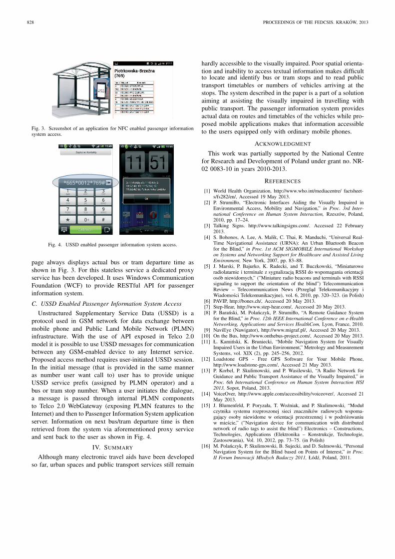
Fig. 3. Screenshot of an application for NFC enabled passenger informationsystem access.
Fig. 4. USSD enabled passenger information system access.
page always displays actual bus or tram departure time as
shown in Fig. 3. For this stateless service a dedicated proxy
service has been developed. It uses Windows Communication
Foundation (WCF) to provide RESTful API for passenger
information system.
C. USSD Enabled Passenger Information System Access
Unstructured Supplementary Service Data (USSD) is a
protocol used in GSM network for data exchange between
mobile phone and Public Land Mobile Network (PLMN)
infrastructure. With the use of API exposed in Telco 2.0
model it is possible to use USSD messages for communication
between any GSM-enabled device to any Internet service.
Proposed access method requires user-initiated USSD session.
In the initial message (that is provided in the same manner
as number user want call to) user has to provide unique
USSD service prefix (assigned by PLMN operator) and a
bus or tram stop number. When a user initiates the dialogue,
a message is passed through internal PLMN components
to Telco 2.0 WebGateway (exposing PLMN features to the
Internet) and then to Passenger Information System application
server. Information on next bus/tram departure time is then
retrieved from the system via aforementioned proxy service
and sent back to the user as shown in Fig. 4.
IV. SUMMARY
Although many electronic travel aids have been developed
so far, urban spaces and public transport services still remain
hardly accessible to the visually impaired. Poor spatial orienta-
tion and inability to access textual information makes difficultto locate and identify bus or tram stops and to read public
transport timetables or numbers of vehicles arriving at the
stops. The system described in the paper is a part of a solution
aiming at assisting the visually impaired in travelling with
public transport. The passenger information system provides
actual data on routes and timetables of the vehicles while pro-
posed mobile applications makes that information accessible
to the users equipped only with ordinary mobile phones.
ACKNOWLEDGMENT
This work was partially supported by the National Centre
for Research and Development of Poland under grant no. NR-
02 0083-10 in years 2010-2013.
REFERENCES
[1] World Health Organization, http://www.who.int/mediacentre/ factsheet-s/fs282/en/, Accessed 19 May 2013.
[2] P. Strumiłło, “Electronic Interfaces Aiding the Visually Impaired inEnvironmental Access, Mobility and Navigation,” in Proc. 3rd Inter-
national Conference on Human System Interaction, Rzeszów, Poland,2010, pp. 17–24.
[3] Talking Signs. http://www.talkingsigns.com/. Accessed 22 February2013.
[4] S. Bohonos, A. Lee, A. Malik, C. Thai, R. Manduchi, “Universal Real-Time Navigational Assistance (URNA): An Urban Bluetooth Beaconfor the Blind,” in Proc. 1st ACM SIGMOBILE International Workshop
on Systems and Networking Support for Healthcare and Assisted Living
Environment, New York, 2007, pp. 83–88.[5] J. Marski, P. Bajurko, K. Radecki, and T. Buczkowski, “Miniaturowe
radiolatarnie i terminale z sygnalizacja RSSI do wspomagania orientacjiosób niewidomych,” (”Miniature radio beacons and terminals with RSSIsignaling to support the orientation of the blind”) TelecommunicationReview – Telecommunication News (Przeglad Telekomunikacyjny iWiadomosci Telekomunikacyjne), vol. 6, 2010, pp. 320–323. (in Polish)
[6] PAVIP, http://bones.ch/, Accessed 20 May 2013.[7] Step-Hear, http://www.step-hear.com/, Accessed 20 May 2013.[8] P. Baranski, M. Polanczyk, P. Strumiłło, “A Remote Guidance System
for the Blind,” in Proc. 12th IEEE International Conference on e-Health
Networking, Applications and Services HealthCom, Lyon, France, 2010.[9] NaviEye (Nawigator), http://www.migraf.pl/, Accessed 20 May 2013.
[10] On the Bus, http://www.onthebus-project.com/, Accessed 20 May 2013.[11] Ł. Kaminski, K. Bruniecki, “Mobile Navigation System for Visually
Impaired Users in the Urban Environment,” Metrology and MeasurementSystems, vol. XIX (2), pp. 245–256, 2012.
[12] Loadstone GPS - Free GPS Software for Your Mobile Phone,http://www.loadstone-gps.com/, Accessed 21 May 2013.
[13] P. Korbel, P. Skulimowski, and P. Wasilewski, “A Radio Network forGuidance and Public Transport Assistance of the Visually Impaired,” in
Proc. 6th International Conference on Human System Interaction HSI
2013, Sopot, Poland, 2013.[14] VoiceOver, http://www.apple.com/accessibility/voiceover/, Accessed 21
May 2013.[15] J. Blumenfeld, P. Poryzała, T. Wozniak, and P. Skulimowski, “Moduł
czytnika systemu rozproszonej sieci znaczników radiowych wspoma-gajacy osoby niewidome w orientacji przestrzennej i w podrózowaniuw miescie,” (”Navigation device for communication with distributednetwork of radio tags to assist the blind”) Electronics – Constructions,Technologies, Applications (Elektronika – Konstrukcje, Technologie,Zastosowania), Vol. 10, 2012, pp. 73–75. (in Polish)
[16] M. Polanczyk, P. Skulimowski, B. Sujecki, and D. Sulmowski, “PersonalNavigation System for the Blind based on Points of Interest,” in Proc.
II Forum Innowacji Młodych Badaczy 2011, Łódz, Poland, 2011.
828 PROCEEDINGS OF THE FEDCSIS. KRAKOW, 2013