Embed Size (px)
Citation preview
Mitigation Banking Instrument Outline
For Proposed Mitigation Banks
Within the State of Missouri (February 2015)
The U.S. Army Corps of Engineers (Corps) and U.S. Environmental Protection Agency joint
regulation for Compensatory Mitigation for Losses of Aquatic Resources, (33 CFR, Part 332 and
40 CFR 230) herein referred to as the Mitigation Rule, improves planning, implementation, and
management of permittee-responsible and third party compensatory mitigation projects. The
purpose of this document is to explain how the Corps Districts whose regulatory boundaries fall
within the State of Missouri and the Interagency Review Team (IRT) members interpret the
required content for mitigation banking documentation.
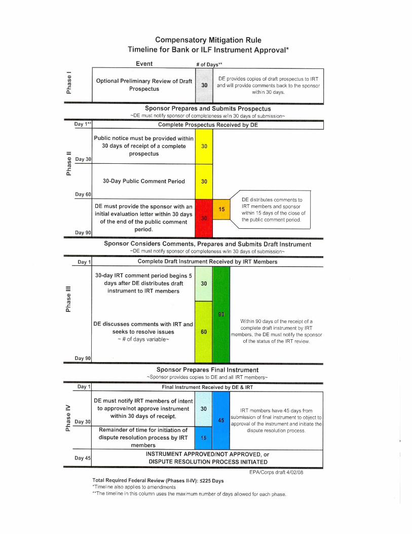
As outlined in the Mitigation Rule, the approval process for the mitigation banking instrument
occurs in four phases. The Compensatory Mitigation Rule Timeline for Bank or ILF Instrument
Approval, is included in Appendix D of this document. Prospective bank sponsors shall submit
the information contained in the following outline to the Corps and to the IRT members in order
to initiate the review process;
Phase I of the review process is recommended, however, it is not required. This phase is the
preliminary review of the proposed mitigation site and is intended to allow the Corps and the
IRT an opportunity to identify potential issues early in the review process so that the sponsor
may attempt to address those issues, or locate an alternative site if recommended, prior to the
start of the formal review process. A draft prospectus is recommended at this stage in order to
assist with the review of the site. Following the preliminary review and the acceptance by the
Corps and the IRT that the site is conducive to aquatic resource improvements, the draft
prospectus shall be revised in order to incorporate the comments of the IRT that result from the
preliminary review. The submittal of the complete prospectus, to the Corps, initiates phase II of
the review process.
Phase II involves the submittal of the complete prospectus that must describe the items included
in Section I (A – H) below. The complete prospectus will be placed on Public Notice (PN) for a
30-day public comment period. After the bank sponsor considers the comments from the Corps,
the IRT, and the public, and if the sponsor chooses to proceed with the establishment of the
mitigation bank, the sponsor shall incorporate all substantive comments into a draft banking
instrument and submit the draft instrument to the Corps to initiate phase III of the approval
process.
Phase III involves the submittal of the draft banking instrument that describes, in detail, the
physical and the legal characteristics of the mitigation bank including how it will be established,
operated, and managed. It is from the draft instrument that a final instrument (Phase IV) is
prepared. The final instrument is the document by which the Corps determines whether to
approve or deny the establishment of the proposed mitigation bank.
2
Phase IV of the approval process begins after the bank sponsor submits the final instrument to
the Corps and to the members of the IRT. The final instrument must incorporate all comments
provided by the Corps and the IRT in phase III and include supporting documentation that
explains how the final instrument addresses the comments provided by the Corps and the IRT.
After review of the final instrument the Corps will notify the IRT of intent to approve/not
approve the final instrument. If the banking instrument is approved by the Corps District(s),
signatures of the IRT agencies will be requested. If the Corps denies the final instrument the
bank sponsor will be notified and the final instrument may be modified until an agreement is
reached. A graphic depiction of the review process is included as Appendix D of this document.
Two outlines are provided below and are intended to assist the prospective bank sponsor in
preparing and providing the phased approach documentation required by the Corps and IRT.
The first outline lists the requirements for a complete prospectus as outlined in the Mitigation
Rule. However, the primary emphasis of this document is placed on the draft banking
instrument outline. The outline consolidates four sections of the Mitigation Rule into the
arrangement and content to be addressed in the draft banking instrument and provides
prospective bank sponsors with a predictable and transparent rationale for submitting the
required documentation.
I. Requirements for a Complete Prospectus
A. The objectives of the proposed mitigation bank.
B. How the mitigation bank will be established and operated.
The following provision must be included in this section of the Prospectus and must
also be included in the Draft and Final Instrument. The bold font must be maintained
in the Instrument.
The U.S. Army Corps of Engineers (USACE) approval of this Instrument
constitutes the regulatory approval required for the [INSERT NAME OF THE
MITIGATION BANK] to be used to provide compensatory mitigation for
Department of the Army permits pursuant to 33 C.F.R. 332.8(a)(1). This
Instrument is not a contract between the Sponsor or the Property Owner and
the USACE or any other agency of the federal government. Any dispute arising
under the Instrument will not give rise to any claim by the Sponsor or the
Property Owner for monetary damages. This provision is controlling
notwithstanding any other provision or statement in the Instrument to the
contrary.
C. The proposed service area (See Section II (3) below).
D. The general need for and technical feasibility of the proposed mitigation bank.
E. The proposed ownership arrangements and long-term management strategy
3
F. The qualifications of the sponsor to successfully complete the type(s) of mitigation
project(s) proposed, including information describing any past such activities by the
sponsor.
G. The ecological suitability of the site to achieve the objectives of the proposed
mitigation bank, including the physical, chemical, and biological characteristics of the
bank site and how that site will support the planned types of aquatic resources and
functions; In addition, include a description of all real estate encumbrances on the
proposed property; and
H. Assurance of a sufficient water source to support the long-term sustainability of the
mitigation bank and disclose any split estate mineral rights or other existing real
estate encumbrances on the proposed property.
II. Requirements for the Draft/Final Banking Instrument
1) Introduction of the Mitigation Bank Site
A. Describe the location, including map(s), of the proposed bank site.
1. Provide a shape file with metadata for the project site boundary, Section, Township
and Range and the Latitude and Longitude (decimal degrees) of the center point of
the bank site
B. Describe how the bank will be established and operated.
C. Describe the current and the long-term ownership arrangements including the long-term
management strategy for the bank.
D. Describe the qualifications of the sponsor to successfully complete the construction of the
mitigation bank site. Provide information on past experience regarding the construction
of wetland restoration/creation projects and/or stream restoration projects.
E. Provision stating that legal responsibility for providing the compensatory mitigation is
with the sponsor once a permittee secures credits from the sponsor.
2) Watershed Approach to Mitigation Bank
A. Define your watershed boundary and incorporate the watershed approach (items 1
through 5 below) to address how the mitigation proposal will benefit wetland habitats,
water quality, hydrologic conditions, and species needs within the identified watershed
boundary.
1. Identify and briefly discuss historic losses and current trends of losses of wetland and
wildlife habitats within the watershed based on current and historic land use.
2. Identify and briefly discuss water quality issues present within the watershed.
3. Describe the immediate and the long-term needs of the watershed to improve both the
wildlife habitats and the water quality and describe the suitability (technical
feasibility) of the site to meet the needs of the watershed.
4. Describe the historic and the current state of the bank site and the adjacent lands. In
addition, describe the ecological suitability (physical, chemical and biological
characteristics) of the site to achieve the objectives of the bank and to improve the
conditions within the identified watershed.
4
5. Identify and discuss the short-term and the long-term off-site threats (including water
rights) within the watershed that may affect the wetland and the water quality services
constructed at the bank site. Discuss how these threats are addressed in order to
assure longevity of services at the site.
3) Service Area for the Mitigation Bank Site
A. The service area for a bank should be defined as an appropriately sized watershed or part
of a watershed where aquatic resource functions and services can be mitigated. Smaller
watersheds are more appropriate when the aquatic functions and services are needed at a
lesser scale or where these are found to vary at a larger scale when applying the
watershed approach.
1. Large service areas will have to be justified by the watershed approach and the overall
suitability of the proposed bank site to provide flood attenuation, water quality
benefits, habitat for wildlife, and resource type replacement for wetlands and streams
that are most likely to be impacted or are in need of restoration or establishment in the
proposed service area.
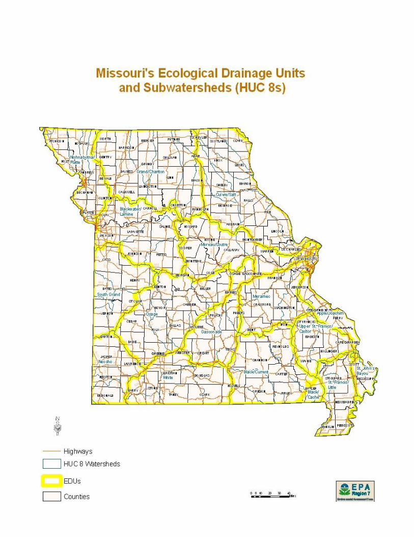
2. The Corps Districts and the IRT have agreed that the Ecological Drainage Unit (EDU)
is the largest service area unit that will be considered for mitigation banks (see
Appendix A).
3. The following are examples when the EDU concept for geographic service area may
not be practicable: an EDU containing a river with an expansive geomorphic
floodplain (i.e. Mississippi River), or a densely populated area exists within an EDU
that also contains large non-urbanized areas.
B. Provide a map outlining the proposed service area along with a shape file of the service
area boundary. The Shapefile for the service area must in the:
Geographic Coordinate System
North American Datum 1983 with units in degrees
The Shapefile should only contain the Service Area for the particular bank
4) Mitigation Plan Requirements for the Bank Site
A. Objectives
1. Specific objectives must identify:
a. The resources to be provided (e.g., forested or emergent wetlands with species
composition matching reference aquatic resources of similar type and landscape
position in the service area, stream type, order, classification such as Rosgen, and
channel-floodplain connectivity)
b. The final goal to be provided by the resource for: amount (e.g., acres, linear feet);
function (e.g., channel stability, shading of riverine system, vegetative structure,
reconnect stream to floodplain); and/or services (e.g., filtering nutrients from
agricultural runoff, provide quality habitat for a specific species of concern,
provide flood water capacity, improve aquatic species passage),
c. The method of compensation (i.e., restoration, enhancement, establishment,
preservation), and
d. The feasibility of establishing the desired resource.
5
2. Briefly describe how the resources provided will address the needs of the watershed
and the proposed service area.
B. Site Selection
1. Compensatory mitigation projects shall use a watershed approach in order to be
appropriately sited and designed to ensure that natural hydrology and landscape
position will support long-term sustainability and function as a self-sustaining system.
Discuss how the bank site is ecologically suitable for providing the desired aquatic
resource functions by describing:
a. The hydrological conditions, soil properties, native seed source, and other physical
and chemical characteristics.
b. The watershed-scale features such as aquatic habitat diversity, habitat
connectivity, the existence of threatened or endangered species related to prior
habitat loss, and other landscape scale functions.
c. The size and the location of the bank site relative to hydrologic sources (including
the availability of water rights) and other ecological features.
d. The compatibility with adjacent land uses and any existing watershed management
plans.
e. The reasonably foreseeable effects the compensatory mitigation project will have
on ecologically important aquatic or terrestrial resources, cultural resources, or
habitat for federally or state listed threatened and endangered species.
f. Other information as available including potential chemical contamination, impacts
from land use changes including residential and/or commercial development
within the watershed, and the proximity to the location of other mitigation banks,
in-lieu fee mitigation project sites, or protected conservation areas within the
watershed.
C. Site Protection Instrument
1. Describe the ownership, legal arrangements and instrument that will be used to ensure
the long-term protection of the proposed mitigation bank site. Include the draft real
estate instrument as an appendix to the draft banking instrument.
a. For long-term protection of non-government property other than transfer of title,
the use of conservation easements and/or deed restrictions are deemed sufficient
site protection measures. A conservation easement, deed restriction, or restrictive
covenant should, where practicable, establish an appropriate third party (e.g.,
governmental or non-profit resource management agency) the right to enforce site
protections and provide the third party the resources necessary to monitor and
enforce the site protections.
b. The long-term protection mechanism must contain a provision requiring 60-day
advance notification to the district engineer before any action is taken to void or
modify the instrument, management plan, or long-term protection mechanism,
including transfer of title to, or establishment of any other legal claims over, the
compensatory mitigation bank site.
c. For government property, long-term protection may be provided through federal
facility management plans or integrated natural resources management plans as
long as those plans are compatible with restrictive covenants specified on non-
government property.
6
D. Baseline Information
1. Describe the ecological characteristics of the proposed bank site.
2. Describe the historic and the existing plant communities, historic and existing
hydrology, and existing soil conditions.
3. Include map(s) identifying the boundary of the proposed bank site with coordinates
(Latitude and Longitude in decimal degrees). Include a shape file with metadata of
the delineated boundary.
4. Conduct a wetland delineation using appropriate Regional Supplement or if a
supplement is not implemented in a geographic area of the State use the routine
delineation methods as described in the Corps of Engineers 1987 Wetland
Delineation Manual.
5. Describe the existing hydro-system connectivity between wetlands and other waters
including tributaries connection to receiving waters.
E. Determination of Credits
1. Describe the number of and the type of proposed credits to be provided at the bank
including a brief explanation of the rationale for this determination.
a. Wetland credit types shall be identified to the Cowardin class (e.g., PFOs, PSS,
PEM). In the absence of a condition or functional assessment method, wetland
credits will be determined based on a combination of land area and the method of
compensation (restoration, enhancement, establishment, and/or preservation),
with a maximum credit value given not to exceed 1 credit for each 1 acre gain in
wetland area. Upon implementation of a functional or condition assessment
method in the State of Missouri the approved methodology will be used to assess
wetland credits.
b. Upland buffers next to wetlands that provide habitat connectivity and other
ecological functions may also generate compensatory mitigation credits because
of their contribution to the ecological functions of the overall mitigation bank.
The Corps in consultation with the IRT will determine on a case-by-case basis
when buffers are essential to maintaining the ecological viability of adjoining
aquatic resources, and thus eligible to produce compensatory mitigation credits.
Credits will be determined on a percentage of land area, habitat connectivity, and
ecological functions to be included as buffer until a condition or functional
assessment methodology is approved for the State.
c. The amount of stream mitigation credit, created at the site, is determined by
stream type (ephemeral, intermittent, perennial), the location, the condition, in-
stream improvements and linear feet of stream included in the bank. These
factors are determined using the State of Missouri Stream Mitigation Method
which derives a value expressed in credit.
d. Riparian areas are critical components of stream ecosystems that provide
important ecological functions, and directly influence the functions of streams,
especially in terms of habitat quality and water quality. Therefore, it is important
for mitigation banks containing streams and other open waters to include riparian
areas as part of the overall compensatory mitigation project. In such cases,
compensatory mitigation credits should also be awarded to riparian areas in
accordance with the State of Missouri Stream Mitigation Method.
7
F. Mitigation Work Plan
1. Describe in detail the specifications and work descriptions of the compensatory
mitigation project, including, but not limited to the geographic boundaries of the
project; construction methods; timing; and sequence.
2. Describe the sources of water, including connections to existing waters and uplands,
and anticipated seasonal water depths in the wetland (water budget).
3. Describe the methods for establishing the desired plant community and plans to
control undesirable plant species, including species composition and type of plantings
(i.e. seeding, propagules, seedlings, saplings, etc.) and height of saplings. If trees are
being planted, include a plan for how to control for wildlife damage.
4. Include any grading plan identifying the location and the elevation of the constructed
features proposed.
5. For stream projects include existing channel cross-sections, proposed alterations to the
stream channel and/or stream banks, a description of in-stream structures including
materials used for improvements, dimensions and elevations, and riparian plantings.
G. Operation and Maintenance Plan
1. A description and a schedule of maintenance required to maintain the viability of the
bank site once the initial construction is completed [e.g. mowing timing and
frequency, herbicide (application method, timing, type, and frequency), invasive
species management plan, irrigation plan, passive water control structures,
supplemental irrigation source, in-stream structures].
H. Ecological Performance Standards
1. Describe the ecological, administrative, and adaptive management standards that will
be used to determine whether the compensatory mitigation project is achieving its
objectives. The standards must be based on attributes that are objective and verifiable.
They must be based on the best available science that can be measured or assessed in
a practicable manner. The standards should take into account the expected stages of
the aquatic resource development process in order to allow early detection of
potential problems and appropriate adaptive management. The use of reference
aquatic resources (least disturbed and exhibiting the highest levels of functions in the
service area) is encouraged to establish performance standards. This approach can
help ensure that the performance standards are reasonably achievable, by reflecting
the range of variability exhibited by the regional class of aquatic resources as a result
of natural processes and anthropogenic disturbances.
2. The performance standards should relate to the objectives of the mitigation bank site,
so that the project can be quantitatively and/or qualitatively evaluated to determine if
it is developing into the desired resource type, providing the expected functions
and/or services, and attaining any other applicable metrics. Examples include:
a. Structural Measures:
Description-size, classification (HGM, Cowardin, Rosgen) of aquatic
resource(s).
Hydrology-duration, periodicity,
Soils-hydric indicators, redoximorphic features,
Vegetation-dominants, species composition, density, coverage,
8
Stream–status of structures and structural integrity, sinuosity, cross-section,
bank full width, particle size (e.g. no significant change in D50 size particle
silt, sand, gravel, cobble), longitudinal profile.
b. Indicators of attainment or condition: snag density, foliage height, diversity, basal
area, degree of shading, channel profile,
c. Composite measures–FQI, HSIs, IBI, FCI/FCU, etc.
I. Monitoring Requirements
1. Monitoring reports (see Appendix E) must be submitted by the bank sponsor or their
authorized agent in order to determine if the compensatory mitigation project is on
track to meet performance standards and used as a measure to determine if adaptive
management is needed.
2. The bank site must be monitored for a period not less than five years after final
construction and planting. Extending the monitoring period beyond the five year
minimum may be required depending on:
a. Resource type (e.g., forested wetlands, riparian corridors, bottomland hardwood
forests, wet prairie).
b. Adaptive management measures occurring after initial site work (e.g., planting of
additional trees, adjustments/re-building of in-stream structures to address stream
stability).
3. The instrument must include: the parameters to be monitored, monitoring methods and
procedures, a schedule for monitoring; the party responsible for conducting the
monitoring and, if separate, the party responsible for submitting the monitoring
report; and permission for the IRT members to participate in the monitoring process if
requested.
4. Upon a determination by the Corps and IRT that performance standards have not been
met or the compensatory mitigation project is not on track to meet them, the
monitoring period may be extended. The IRT may also revise monitoring
requirements when remediation and/or when an adaptive management plan is
required.
J. Long-term Management Plan
1. Describe how the bank will be managed after performance standards have been
achieved to ensure the long-term sustainability of the resources, including a
description of long-term management needs, annual cost estimates for these needs,
identify the funding mechanism that will be used to meet those needs and the party
responsible for carrying out the long-term management activities.
2. The sponsor is encouraged to transfer the long-term management responsibilities for
the bank to a land stewardship entity, such as a public agency, non-governmental
organization, or private land manager, as long as the entity is approved by the IRT. If
the entity is identified in the instrument they shall be signatory to the instrument.
3. In cases where the long-term management entity is a public authority or government
agency, that entity shall provide a plan or give an indication how long-term financing
will be established, and include a written stewardship commitment specifying
commitment to long-term management and maintenance and a plan for financing.
4. Non-governmental organizations shall demonstrate that long-term financing
mechanisms will be implemented. In cases where long-term financing for long-term
9
management of compensatory mitigation projects is necessary, district commanders
should consider the need to make inflationary adjustments and certain financial
assumptions such as total return assumptions and capitalization rates (e.g.
endowments, or Consumer Price Index adjustments in the case of annual payments).
5. The Corps and IRT prefer that the land stewardship entity be identified in the
instrument however the Mitigation Rule provides the prospective sponsor flexibility
to identify the entity at a later time. In this instance, the sponsor will be responsible
for long-term management until the sponsor identifies a long-term stewardship entity
and that entity is approved by the Corps and IRT.
K. Adaptive Management Plan
1. Describe the strategy to address unforeseen changes in site conditions or other
components that adversely affect the bank’s success, including the party or parties
responsible for the development and the implementation of the adaptive management
measures and the timeline for the development and the implementation of the plan.
2. Circumstances that may qualify for adaptive management include an inability to
construct the bank in accordance with the approved mitigation work plans,
monitoring or other information reveals the bank is not progressing towards meeting
its performance standards, possible remedial measures that result in site
modifications, design changes, revisions to maintenance requirements, revised
monitoring requirements.
L. Financial Assurances
1. Describe the financial assurances that will be provided and how they are sufficient to
ensure a high level of confidence that the compensatory mitigation bank will be
successfully completed in accordance with the proposed performance standards.
2. The amount of financial assurances, approved by the district engineer, will be
determined by the size and the complexity of the bank site, the degree of completion
of the project at the time of bank approval, the likelihood of success, the past
performance of the bank sponsor, and any other factors the Corps deems appropriate.
a. The rationale for determining the amount of the required financial assurances
must be documented in the instrument and may include; costs for land acquisition,
planning and engineering, legal fees, mobilization, construction, monitoring, and
maintenance. An alternative to providing an itemized cost analysis, would be to
provide the cost of replacement mitigation through the purchase of credits from an
approved mitigation bank or in-lieu-fee arrangement whose service area
boundaries overlap with the proposed mitigation bank.
3. The financial assurances may be in the form of performance bonds, escrow accounts,
casualty insurance, letters of credit, or other appropriate instruments approved by the
district engineer. The financial assurances must be in the form that ensures the
district engineer will receive notification at least 120 days in advance of any
termination or revocation.
4. For performance bonds or letters of credit a standby trust account must be established.
All amounts paid by the financial assurance provider must be paid directly to the
standby account for distribution by the account trustee in accordance with the Corps’
instructions.
10
5. Financial assurances may be phased out once the bank has been determined by the
Corps to be successful in accordance with its performance standards. Otherwise, the
assurance shall remain in place until the Corps in consultation with the IRT
determines performance standards have been achieved.
6. The instrument must clearly specify the conditions under which the financial
assurances are to be released to the sponsor, and/or other financial assurance provider.
5) Credit Release Schedule for the Mitigation Bank Site
A. All credit releases must be approved by the Corps, in consultation with the IRT, based on
a determination that required milestones have been achieved.
B. Release of credits must be tied to performance based milestones (i.e. construction,
planting, establishment of specified plant communities, bank full events, etc.).
C. Up to 20 percent of the total credits projected may be debited from the bank upon
instrument approval, appropriate financial assurances have been established and funded,
and any other requirements determined to be necessary by the IRT have been fulfilled.
D. The credit release schedule should reserve no less than 20 percent of the total credits for
release only after full achievement of ecological performance standards.
E. In order for credits to be released, the sponsor must submit documentation (i.e. via
monitoring report) to the Corps demonstrating that the appropriate milestones for credit
release have been achieved and requesting the release. The Corps will provide copies of
this documentation to the IRT members for review. IRT members must provide any
comments to the Corps within 15 days of receiving this documentation. However, if the
Corps determines that a site visit is necessary, IRT members must provide any comments
to the Corps within 15 days of the site visit. The Corps must schedule the site visit so that
it occurs as soon as it is practicable, but the site visit may be delayed by seasonal
considerations that affect the ability of the Corps and the IRT to assess whether the
applicable credit release milestones have been achieved. After full consideration of any
comments received, the Corps will determine whether the milestones have been achieved
and the credits can be released. The Corps shall make a decision within 30 days of the
end of that comment period, and notify the sponsor and the IRT.
F. The Corps, in consultation with the IRT, may modify the credit release schedule, reduce
the number of available credits or suspend credit sales or transfers altogether, when
deficiencies in the performance standards have been observed or specific requirements of
the instrument have not been met.
6) Accounting Procedures for the Mitigation Bank Site
A. Use of Credits
1. At the discretion of the Corps, all activities authorized by Department of the Army
permits are eligible, to use the mitigation bank to fulfill compensatory mitigation
requirements for DA permits, including compensatory mitigation associated with
unauthorized activities or non-compliance actions.
2. The Corps will determine the number and type(s) of credits required to compensate for
the authorized impacts.
B. Ledger
1. The instrument must contain a provision requiring the sponsor to establish and
maintain a ledger to account for all credit transactions. The sponsor must notify the
11
Corps each time a credit transaction occurs and the sponsor must provide an updated
ledger.
7) Reporting for the Mitigation Bank Site
A. Monitoring Reports
1. Monitoring reports must be submitted (a minimum of one annually) to the Interagency
Review Team (IRT) for a period not less than five years after final construction and
planting.
2. The monitoring report must be provided in the format cited in Regulatory Guidance
Letter 08-03 and be of sufficient content for the district engineer, in consultation with
the IRT, to determine that the bank site is progressing towards meeting the
performance standards as outlined in the instrument.
3. The monitoring report must include as-built drawings, maps, and ground photography
illustrating the site conditions and interpretation of the current site conditions. If
available, approved wetland and/or stream assessment methods that provide
qualitative measures of the functions of the resource can be submitted.
B. Ledger Accounting Reports.
1. The sponsor must compile an annual ledger report showing the beginning and ending
balance of available credits and permitted impacts for each resource type, including
types of credits debited, all additions and subtractions of credits, and any other
changes in credit availability (e.g., additional credits released, credit sales suspended).
2. The ledger report must be submitted to the Corps and IRT on an annual basis. The
ledger report will serve as part of the administrative record for the mitigation bank.
C. Financial Assurances Reports
1. The sponsor must provide an annual report showing beginning and ending balances,
including deposits into and any withdrawals from, the accounts providing funds for
financial assurances.
2. The report shall include information on the amount of required financial assurances
and the status of those assurances, including their potential expiration.
8) Default and Closure Provisions
A. Default Provisions
1. If the Corps determines that the mitigation bank is not meeting performance standards
or complying with the terms of the instrument, appropriate action will be taken. Such
actions may include, but are not limited to, suspending credit sales, adaptive
management, decreasing available credits, utilizing financial assurances, and/or
terminating the instrument.
B. Closure Provisions
1. Bank closure will occur when the terms and conditions of an instrument have been
determined by the Corps, in consultation with the IRT, to be fully satisfied or until all
credits have been debited, whichever is later. Subsequent to bank closure,
management will remain the responsibility of the sponsor unless a Long-Term
Management entity is identified in the Long-Term Management Section of the
instrument.
12
2. If adaptive management strategies are unsuccessful and performance standards are
unattainable, the sponsor may request early closure of a bank and forfeiture of
remaining anticipated credits if it is determined that the performance standards
are unattainable.
9) Approval of the Final Instrument and the Incorporation of the IRT’s Comments
A. The bank sponsor must submit, for approval, a final bank instrument to the Corps that
adequately addresses the main topics and subtopics contained within this bank instrument
guidance document. The final instrument must also include supporting documentation
outlining how the final instrument addresses the comments provided by the IRT.
Mitigation credit cannot be sold at the bank prior to the approval of the final bank
instrument by the Corps in consultation with the IRT.
Appendices
Appendix A – Ecological Drainage Unit (EDU) Map
Appendix B – District Specific Site Protection Example(s) (e.g. Conservation Easement, Deed Restriction, etc.)
Appendix C – District Specific Financial Assurance Example(s) (e.g. performance bond, letter of credit, etc.)
Appendix D – Compensatory Mitigation Rule Timeline for Bank or ILF Approval
Appendix E – Regulatory Guidance Letter 08-03
Appendix A
Ecological Drainage Unit (EDU) Map
(See Map on Following Page)
Additional Map Available at:
http://www.atlas.moherp.org/missouri/edu/
Appendix B
District Specific Site Protection Example(s) (See Conservation Easement and Deed Restriction Templates for Kansas
and Missouri on the Following Pages)

CONSERVATION EASEMENT
THIS DEED OF CONSERVATION EASEMENT is given this _____ day of
_______________, 20__, by ____________________________________, having an address of
_________________________________ ("Grantor") to ________________________________,
having an address of _____________________________________ ("Grantee"). As used herein,
the term "Grantor" shall include any and all heirs, successors, or assigns of the Grantor, and all
subsequent owners of the Property (as hereinafter defined), and the term "Grantee" shall include
any successor or assignee of Grantee.
WITNESSETH:
WHEREAS, Grantor is the sole owner in fee simple title of certain lands situated in
___________ County, Missouri, more particularly described in Exhibit A, attached hereto and
incorporated herein ("Property"); and
WHEREAS, Department Permit No. ___________________of the U.S. Army Corps of
Engineers ("Corps") (hereinafter referred to as the "Permit") authorizes certain activities which
affect waters of the United States; and
WHEREAS, the Permit requires that Grantor preserve, enhance, restore, or mitigate
wetlands or uplands located on the Property; and
WHEREAS, Grantor, in consideration of the issuance of the Permit to construct and
operate the permitted activity, and as an inducement to the issuance of the Permit, is willing to
grant a perpetual Conservation Easement over the Property; and
NOW THEREFORE, in consideration of the above and mutual covenants, terms
conditions, and restrictions contained herein, together with other good and valuable
consideration, the adequacy and receipt of which is hereby acknowledged, Grantor hereby
voluntarily grants and conveys a perpetual Conservation Easement for and in favor of Grantee
upon the property, which shall run with the land and be binding upon the Grantor, and shall
remain in full force and effect forever.
The scope, nature, and character of this Conservation Easement shall be as follows:
1. Purpose: The purpose of this Conservation Easement is to retain and maintain land
or water areas on the Property in their natural, vegetative, hydrologic, scenic, open, or wooded
condition and to retain such areas as suitable habitat for fish, plants, or wildlife. Those wetland
or upland areas that are to be restored, enhanced, created, or preserved on the Property shall be
retained and maintained in the restored, enhanced, created, or preserved condition as described in
the Permit and/or in the associated compensatory mitigation plan for the Property.
2. Rights of Grantee: The following rights are conveyed to the Grantee and to the
Corps by this easement:
a. The right to take action to preserve and protect the environmental value of the
Property; and
b. The right to prevent any activity on or use of the Property that is inconsistent
with the purpose of this Conservation Easement, and to require the restoration of areas or
features of the Property that may be damaged by any inconsistent activity or use;
c. The right to enter upon and inspect the Property in a reasonable manner and at
reasonable times to determine if Grantor is complying with the covenants and prohibitions
contained in this Conservation Easement; and
d. The right to proceed at law or in equity to enforce the provisions of this
Conservation Easement, and to prevent the occurrence of any of the prohibited activities
hereinafter set forth.
3. Prohibited Uses: Except for restoration, creation, enhancement, preservation,
maintenance, and monitoring activities, or surface water management improvements, required by
the Permit, or required by the compensatory mitigation plan, or are otherwise approved by the
Corps, the following activities are prohibited on the Property:
a. Construction of any structure or object (i.e., buildings, roads, above or below
ground utilities, signs, billboards etc.) without written approval from the Corps of Engineers
prior to construction;
b. Dumping or placing of soil or other substance or material as landfill, or
dumping or placing of trash, waste, or unsightly or offensive materials;
c. Removal or destruction of trees, shrubs, or other vegetation, except for the
removal of nuisance, exotic, or non-native vegetation in accordance with a maintenance plan
approved by Corps;
d. Planting of nuisance, exotic, or non-native plants as listed by the State of
Missouri;
e. Exploration for, or extraction of, oil or gas in such a manner as to affect the
surface, or excavation, dredging, or removal of coal, loam, peat, gravel, soil, rock, or other
material substance;
f. Use of motorized and non-motorized vehicles, the keeping or riding of horses,
grazing, livestock confinement, or other surface use that may affect the natural condition of the
Property, except for vehicle use for purposes of maintenance and upkeep;
g. Tilling, plowing, planting of crops, digging, mining, or other activities that are
or may be detrimental to drainage, flood control, water conservation, water quality, erosion
control, soil conservation, or fish and wildlife habitat preservation, including but not limited to
ditching, diking, and fencing;
2
h. The extraction of water from the Property or the impoundment of water on the
Property so as to affect the hydrology of the Property;
i. Acts or uses detrimental to the aforementioned retention and maintenance of
land or water areas;
j. Acts or uses detrimental to the preservation of the structural integrity or
physical appearance of sites or properties of historical, architectural, archaeological, or cultural
significance.
4. Reserved Rights: Grantor reserves all rights as owner of the Property, including the
right to engage in uses of the Property that are not prohibited herein, and that are not inconsistent
with the intent and purposes of this Conservation Easement.
5. Taxes: Grantor shall pay any and all applicable real property taxes and assessments
levied by competent taxing authority on the Property.
6. Maintenance: Grantor shall, at Grantor's sole expense, operate, maintain and keep up
the Property consistent with the purpose of this Conservation Easement. Grantor shall remove
from the Property any nuisance, exotic, or non-native plants as listed by the State of Missouri
and shall maintain the hydrology of the Property as it currently exists or as otherwise required by
the Permit or as required by the compensatory mitigation plan or as required by the Corps
approved final mitigation banking instrument.
7. Hazardous Waste: Grantor covenants that if any hazardous substances or toxic
waste exist or has been generated, treated, stored, used, disposed of, or deposited in or on the
Property, or there are or have been any underground storage tanks on the Property, Grantor shall
be responsible for any and all necessary costs of remediation.
8. Public Access: No right of access by the general public to any portion of the Property
is conveyed by this Conservation Easement.
9. Liability: Grantor shall continue to retain all liability for any injury or damage to the
person or property of third parties that may occur on the Property arising from ownership of the
Property. Neither Grantor, nor any person claiming by or through Grantor, shall hold Grantee
liable for any damage or injury that may occur on the Property.
10. Recording Requirements: Grantor must record this Conservation Easement in the
official records of ____________ County, Missouri, and shall re-record it at any time Grantee or
the Corps may require to preserve their rights. Grantor shall pay all recording costs, fees and
taxes necessary at any time to record this Conservation Easement in the public records. Grantor
shall thereafter insert the terms and restrictions of this Conservation Easement in any subsequent
deed or other legal instrument by which Grantor divests himself/herself/itself of any interest in
the Property, and shall provide a photocopy of the recorded Conservation Easement to the new
owner(s).
3
11. Enforcement: The terms and conditions of this Conservation Easement may be
enforced in an action at law or equity by the Grantee or the Corps against the Grantor violating
or attempting to violate these Restrictions. Venue for any such action shall be in
__________ County, Missouri. Enforcement of this Conservation Easement shall be at the
reasonable discretion of the Grantee or the Corps, and any forbearance on behalf of Grantee or
the Corps to exercise its or their rights hereunder in the event of any breach by Grantor shall not
be deemed or construed to be a waiver of rights. Any costs incurred in enforcing, judicially or
otherwise, the terms, provisions, and restrictions of this Conservation Easement, including
without limitation, the costs of suit, and attorney's fees, shall be borne by and recoverable against
the non-prevailing party in such proceedings, except that such costs shall not be recoverable
against the Corps. In addition, if the Grantee or the Corps shall prevail in an enforcement action,
such party shall also be entitled to recover that party's cost of restoring the land to the natural
vegetative and hydrologic condition existing at the time of execution of these Restrictions or to
the vegetative and hydrologic condition required by the Permit and/or as required by the
associated compensatory mitigation plan.
12. Assignment of Rights: Grantee shall hold this Conservation Easement exclusively
for conservation purposes. Grantee will not assign its rights and obligations under this
Conservation Easement, except to another legal entity qualified to hold such interests under
applicable state and federal laws and committed to holding this Conservation Easement
exclusively for the purposes stated herein. Grantee shall notify the Corps in writing of any
intention to reassign this Conservation Easement to a new grantee at least sixty (60) days in
advance thereof, and the Corps must accept the assignment in writing. The new grantee shall
then deliver a written acceptance to the Corps. The assignment instrument must then be recorded
and indexed in the same manner as any other instrument affecting title to real property and a
copy of the assignment instrument shall be furnished to the Corps. Failure to comply with the
assignment procedure herein stated shall result in invalidity of the assignment. In the event of
dissolution of the Grantee or any successor, or failure for 60 days or more to execute the
obligations of this Conservation Easement, the Grantee shall transfer this Conservation Easement
to a qualified and willing grantee. Upon failure of the Grantee or any successor to so transfer the
Conservation Easement, the Corps shall have the right to sue to force such an assignment to a
grantee to be identified by the Court.
13. Successors: The covenants, terms, conditions, and restrictions of this Conservation
Easement shall be binding upon, and inure to the benefit of the parties hereto and their respective
personal representatives, heirs, successors, and assigns, and shall continue as a servitude running
in perpetuity with the Property.
14. Notices: All notices, consents, approvals, or other communications hereunder shall
be in writing and shall be deemed properly given if sent by United States certified mail, return
receipt requested, addressed to the appropriate party or successor-in-interest.
4
15. Severability: If any provision of this Conservation Easement or the application
thereof to any person or circumstances is found to be invalid, the remainder of the provisions of
this Conservation Easement shall not be affected thereby, as long as the purpose of the
Conservation Easement is preserved.
16. Alteration or Revocation: This Conservation Easement, granted in perpetuity, may
be amended, altered, released, canceled, or revoked only by written agreement between the
parties hereto or their heirs, assigns, or successors in interest, which shall be filed in the public
records of ______________ County, Missouri. No action shall be taken, however, without
advance written approval thereof by the Corps. Corps approval shall be by letter attached as an
exhibit to the document amending, altering, canceling, or revoking the Conservation Easement,
and said letter shall be informal and shall not require notarization. It is understood and agreed
that Corps approval requires a minimum of sixty (60) days written notice, and that the Corps
may require substitute or additional mitigation, a separate conservation easement or alternate
deed restrictions, or other requirements as a condition of approval. Any amendment, alteration,
release, cancellation, or revocation together with written Corps approval thereof shall then be
filed in the public records of ______________ County, Missouri, within 30 days thereafter.
17. Controlling Law: The interpretation and performance of this Conservation
Easement shall be governed by the laws of the State of Missouri.
GRANTOR FURTHER COVENANTS that Grantor is lawfully seised of said Property
in fee simple; that the Property is free and clear of all encumbrances that are inconsistent with
the terms of this Conservation Easement and that no mortgages or other liens exist; that Grantor
has good right and lawful authority to convey this Conservation Easement, and that it hereby
fully warrants and defends the title to the Conservation Easement hereby conveyed against the
lawful claims of all persons whomsoever.
TO HAVE AND TO HOLD, the Grantor covenants that he, she, or they are vested with
good title to the easement area and will warrant and defend the same on behalf of the Grantee
against all claims and demands. The Grantor covenants to comply with the terms and conditions
enumerated in this document for the use of the easement area and adjacent lands for access, and
to refrain from any activity not specifically allowed or that is inconsistent with the purposes of
this easement deed. The covenants, terms, conditions, restrictions, and purpose imposed with
this Conservation Easement shall be binding upon Grantor, and shall continue as a servitude
running in perpetuity with the Property.
Dated this______day of______________, 20_____
Grantor(s):_______________________________________________
Print Name
_______________________________________________
Signature
________________________________________________
Print Name
________________________________________________
Signature
5
ACKNOWLEDGEMENT
STATE OF ______________________
COUNTY OF ________________________
On this_____ day of ____________________, 20_____, before me, the undersigned, a
Notary Public in and for said State personally appeared ________________________, know or
proved to me to be the person{s) described in and who executed the foregoing instrument, and
acknowledged that ______ executed the same as ___________ free act and deed.
IN TESTIMONY WHEREOF, I have hereunto set my hand and official seal the day and
year first above written.
Notary Public for the State of ____________________
Residing at __________________________________
__________________________________
My Commission Expires________________________
ACCEPTANCE BY GRANTEE:
I ______________________________(print name), _______________________ (title), being
the duly authorized representative of the Grantee, do hereby accept this Conservation Easement
Deed with respect to the rights and duties of the, Grantee.
Dated this _______ day of ____________________, 20____.
__________________________
Signature
__________________________
Title
6
DECLARATION OF RESTRICTIVE COVENANTS
The Declarant, __________________________, is the fee simple owner of the certain real
property located in __________ County, Missouri, as described on Exhibit A, which is attached
hereto and incorporated herein by reference (the "Development"). Declarant has applied for and
received Permit No. ____________ from the United States Army Corps of Engineers (the
"Corps") to fill certain wetlands in waters of the United States (the "Permit"). In consideration of
the issuance of the Permit and in compliance with the terms thereof, and for other good and
valuable consideration, the Declarant hereby declares that that the portion of the Development
described in Exhibit B ("the Property") shall henceforth be subject to the following restrictive
covenants (the "Restrictions"). As used herein, the term "Declarant" includes and shall be
binding upon ______________ and his/her/its successors, heirs, and assigns.
1. Purpose: The purpose of these Restrictions is to retain and maintain land or water
areas on the Property in their natural, vegetative, hydrologic, scenic, open, agricultural, or
wooded condition, and to retain such areas as suitable habitat for fish, plants, or wildlife. Those
wetland or upland areas that are to be restored, enhanced, or created pursuant to the Permit shall
be retained and maintained in the restored, enhanced, or created condition required by the
Permit.
2. Rights of Corps and Owners in the Development: The following rights are
conveyed to the Corps and any Owner of any parcel of real estate in the Development (the
"Owner" or "Owners"):
a. The right to take action to preserve and protect the environmental value of the
Property; and
b. The right to prevent any activity on or use of the Property that is inconsistent
with the purpose of these Restrictions, and to require the restoration of areas or features of the
Property that may be damaged by any inconsistent activity or use;
c. The right to enter upon and inspect the Property in a reasonable manner and at
reasonable times to determine if the Declarant is complying with the covenants and prohibitions
contained in these Restrictions; and
d. The right to proceed at law or in equity to enforce the provisions of these
Restrictions, and to prevent the occurrence of any of the prohibited activities hereinafter set
forth.
3. Prohibited Uses: Except for restoration, creation, enhancement, maintenance, and
monitoring activities, or surface water management improvements, which are permitted or
required by the Permit, the following activities are prohibited on the Property:
a. Construction of any structure or object (i.e., buildings, roads, above or below
ground utilities, signs, billboards etc.) without written approval from the Corps of Engineers
prior to construction;
b. Dumping or placing of soil or other substance or material as landfill, or
dumping or placing of trash, waste, or unsightly or offensive materials;
c. Removal or destruction of trees, shrubs, or other vegetation, except as may be
permitted by the Permit, and except for the removal of nuisance, exotic, or non-native vegetation
in accordance with a maintenance plan approved by the Corps;
d. Planting of nuisance, exotic, or non-native plants as listed by the State of
Missouri;
e. Exploration for, or extraction of, oil or gas in such a manner as to affect the
surface, or excavation, dredging, or removal of coal, loam, peat, gravel, soil, rock, or other
material substance, except as may be permitted or required by the Permit;
f. Use of motorized and non-motorized vehicles, the keeping or riding of horses,
grazing, livestock confinement, or other surface use that may affect the natural condition of the
Property, except for vehicle use for purposes of maintenance and upkeep, or as otherwise may be
permitted or required by the Permit;
g. Tilling, plowing, planting of crops, digging, mining, or other activities that are
or may be detrimental to drainage, flood control, water conservation, water quality, erosion
control, soil conservation, or fish and wildlife habitat preservation, including but not limited to
ditching, diking, and fencing, except as permitted or required by the Permit;
h. The extraction of water from the Property or adjacent properties owned by
Grantor, or the impoundment of water on the Property or on adjacent properties owned by
Grantor, so as to affect the hydrology of the Property;
i. Acts or uses detrimental to the aforementioned retention and maintenance of
land or water areas;
j. Acts or uses detrimental to the preservation of the structural integrity or
physical appearance of sites or properties of historical, architectural, archaeological, or cultural
significance.
4. Reserved Rights: Declarant reserves all rights as owner of the Property, including
the right to engage in uses of the Property that are not prohibited herein and that are not
inconsistent with any Corps rule, criteria, permit, or the intent and purposes of these Restrictions.
5. Taxes: Declarant shall pay any and all applicable real property taxes and assessments
levied by competent taxing authority on the Property.
6. Maintenance: [See highlighted text in Para. 6 of Conservation Easement] Declarant
shall, at Declarant's sole expense, operate, maintain and keep up the Property consistent with the
purpose of these Restrictions. Declarant shall remove from the Property any nuisance, exotic, or
non-native plants as listed by the State of Missouri and shall maintain the hydrology of the
Property as it currently exists or as otherwise required by the Permit.
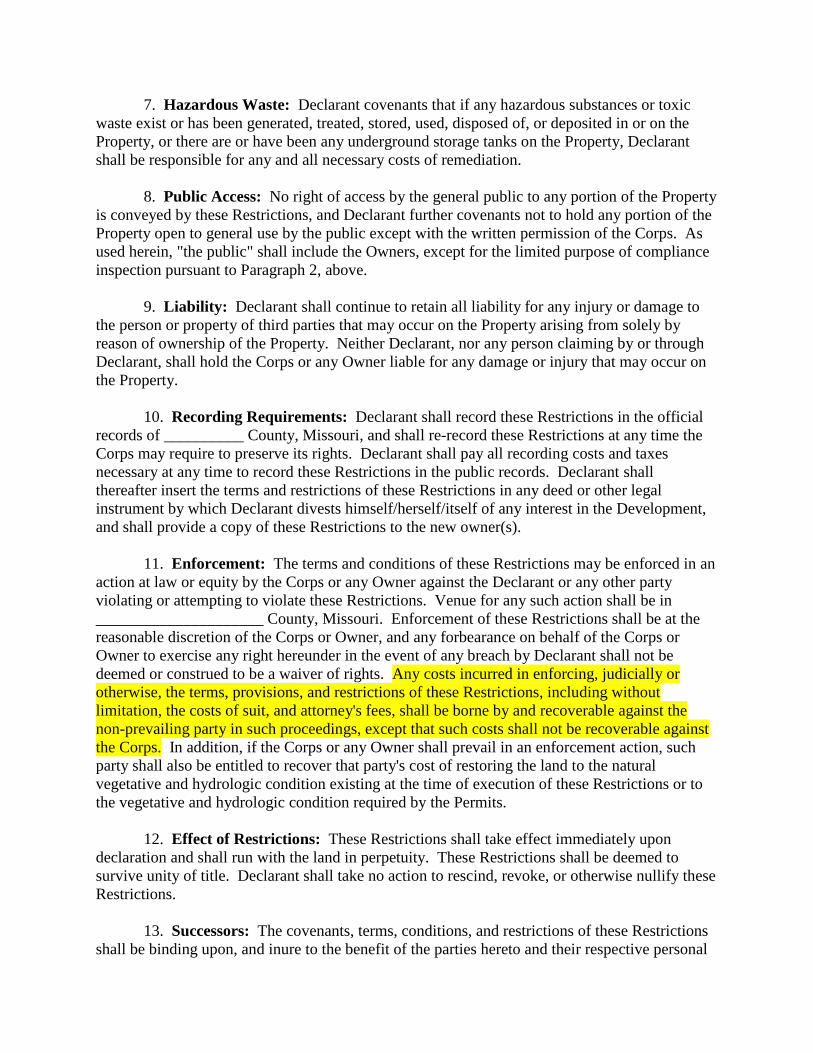
7. Hazardous Waste: Declarant covenants that if any hazardous substances or toxic
waste exist or has been generated, treated, stored, used, disposed of, or deposited in or on the
Property, or there are or have been any underground storage tanks on the Property, Declarant
shall be responsible for any and all necessary costs of remediation.
8. Public Access: No right of access by the general public to any portion of the Property
is conveyed by these Restrictions, and Declarant further covenants not to hold any portion of the
Property open to general use by the public except with the written permission of the Corps. As
used herein, "the public" shall include the Owners, except for the limited purpose of compliance
inspection pursuant to Paragraph 2, above.
9. Liability: Declarant shall continue to retain all liability for any injury or damage to
the person or property of third parties that may occur on the Property arising from solely by
reason of ownership of the Property. Neither Declarant, nor any person claiming by or through
Declarant, shall hold the Corps or any Owner liable for any damage or injury that may occur on
the Property.
10. Recording Requirements: Declarant shall record these Restrictions in the official
records of __________ County, Missouri, and shall re-record these Restrictions at any time the
Corps may require to preserve its rights. Declarant shall pay all recording costs and taxes
necessary at any time to record these Restrictions in the public records. Declarant shall
thereafter insert the terms and restrictions of these Restrictions in any deed or other legal
instrument by which Declarant divests himself/herself/itself of any interest in the Development,
and shall provide a copy of these Restrictions to the new owner(s).
11. Enforcement: The terms and conditions of these Restrictions may be enforced in an
action at law or equity by the Corps or any Owner against the Declarant or any other party
violating or attempting to violate these Restrictions. Venue for any such action shall be in
_____________________ County, Missouri. Enforcement of these Restrictions shall be at the
reasonable discretion of the Corps or Owner, and any forbearance on behalf of the Corps or
Owner to exercise any right hereunder in the event of any breach by Declarant shall not be
deemed or construed to be a waiver of rights. Any costs incurred in enforcing, judicially or
otherwise, the terms, provisions, and restrictions of these Restrictions, including without
limitation, the costs of suit, and attorney's fees, shall be borne by and recoverable against the
non-prevailing party in such proceedings, except that such costs shall not be recoverable against
the Corps. In addition, if the Corps or any Owner shall prevail in an enforcement action, such
party shall also be entitled to recover that party's cost of restoring the land to the natural
vegetative and hydrologic condition existing at the time of execution of these Restrictions or to
the vegetative and hydrologic condition required by the Permits.
12. Effect of Restrictions: These Restrictions shall take effect immediately upon
declaration and shall run with the land in perpetuity. These Restrictions shall be deemed to
survive unity of title. Declarant shall take no action to rescind, revoke, or otherwise nullify these
Restrictions.
13. Successors: The covenants, terms, conditions, and restrictions of these Restrictions
shall be binding upon, and inure to the benefit of the parties hereto and their respective personal
representatives, heirs, successors, and assigns, and shall continue as a servitude running in
perpetuity with the Property.
14. Notices: All notices, consents, approvals, or other communications hereunder shall
be in writing and shall be deemed properly given if sent by United States certified mail, return
receipt requested, addressed to the appropriate party or successor-in-interest. Any and all notices
to the Declarant may be addressed to:
[address and point of contact]
15. Severability: If any provision of these Restrictions or the application thereof to any
person or circumstances is found to be invalid, the remainder of the Restrictions shall not be
affected thereby, as long as the purpose of these Restrictions is preserved.
16. Alteration or Revocation: These Restrictions may be amended, altered, released,
canceled, or revoked only by written agreement between all then-current owners of all parcels of
land located in the Development as shown the by the public records of ___________ County,
Missouri. No action shall be taken, however, without advance written approval by the Corps.
Corps approval shall be by letter attached as an exhibit to the document amending, altering,
canceling, or revoking the Restrictions, and said letter shall be informal and shall not require
notarization. It is understood and agreed that Corps approval requires a minimum of sixty (60)
days written notice to the Corps, and that the Corps may require substitute or additional
mitigation, a separate conservation easement or alternate deed restrictions, or other requirements
as a condition of approval. Any amendment, alteration, release, cancellation, or revocation
together with written Corps approval thereof shall then be filed in the public records of
______________ County, Missouri within 30 days thereafter.
17. Controlling Law: The interpretation and performance of these Restrictions shall be
governed by the laws of the State of Missouri.
IN WITNESS WHEREOF, the Declarant has executed this Declaration of Covenants and
Restrictions this _____ day of _______________, 20___.
Signed in the presence of: DECLARANT:
___________________________________ ______________________________________
Print Witness Name: __________________ By: ________________________________
Print: _____________________
Title: _____________________
___________________________________
Print Witness Name: __________________
STATE OF MISSOURI
COUNTY OF ________________________
The foregoing Declaration of Restrictive Covenants was acknowledged before me this
______day of ____________, 20___, by _____________________as _____________________
of __________________________ who is personally known to me or has produced
__________________________ ________________________ as identification.
My Commission Expires:
______________________________________
NOTARY PUBLIC
Appendix C
District Specific Financial Assurance Example(s)
(Letter of Credit, Performance Bond, etc.) Currently Under Development
EXAMPLE
The Letter of Credit must be on the financial institute’s letterhead
(DATE)
(NAME AND MAILING ADDRESS OF THE STANDBY ACCOUNT HOLDER)
Salutation:
We hereby open our irrevocable credit in favor of the (Name of the standby account holder) for
the sum or sums not to exceed a total of (credit limit ($)) to be made available on the request of
the United State Army Corps of the Engineers (USACE) for payment upon the presentation of a
draft accompanied by the following statement:
The undersigned certifies that a claim is presented against the (Mitigation Bank Name) as
it has been determined by the USACE and the Interagency Review Team (IRT) that (Bank
Sponsor) has defaulted on some or all of the obligations, covenants, terms, and conditions
of the (Bank Name Instrument) and the amount of the drawing will be used to implement
corrective measures at the mitigation bank site or other alternative. Under (Letter of
Credit Identification) we are providing this documentation instructing the (financial
institution(s)) to pay proceeds in the amount of (dollar amount) as determined by the
USACE to be sufficient to bring the mitigation bank into compliance with the approved
mitigation banking instrument to the (standby trust account holder) to direct the activities
requested by the USACE. Please wire said proceeds to the (standby trust account holder).
This Letter of Credit is valid until (the Bank Sponsor) receives a letter from the USACE stating
that all activities necessary to restore compliance with the banking instrument have been
satisfactorily completed and the success criteria for which compensatory mitigation credits have
been sold are met.
Financial Institution
Authorized Signatory
Title
Appendix D
Compensatory Mitigation Rule
Timeline for Bank or ILF Approval (See Following Page)