Embed Size (px)
Citation preview


2
Mission of the Comparative Sedimentology LaboratoryThe research at the Comparative Sedimentology Laboratory focuses on understanding
the variations in facies, sequence stratigraphy, petrophysical and geochemical propertiesof modern and ancient carbonate systems to increase prediction of carbonate reservoirson exploration and production scale.
2003 Planned Projects
A. Carbonate Systems and Reservoir Characterization
• Spatial Characterization of Modern Carbonate Systems• Definition of Litho- and Hydro-Stratigraphic Elements of the Miami Oolitic
Carbonates with 4-D Ground Penetrating Radar.• Multi-Phase Reef Distribution and Resultant Geometries in a Pliocene-Pleistocene
Tropical Mixed System: Bocas del Toro Archipelago, Panama.• Relationship between Fractures and High-Resolution Sequence Stratigraphy.• Comparison of Conjugate Mississippian Carbonate Ramp Margin Successions
and Adjacent Basin Fills, Montana and Idaho.• Relations Among High-Resolution Sequence Architecture, Diagenesis, and
Mechanical Characteristics of Outcropping Lower Carboniferous Grainstones,Missouri.
• Permeability Distribution of Drowned Miocene Platforms, Marion Plateau.
B. Petrophysics of Carbonates
• Pressure, Saturation and Frequency Effects on Velocity Dispersion in Carbonates.• Quantitative 2-D and 3-D Characterization of Carbonate Pore Geometries.• Digital Image Analysis of Carbonate Rocks.• Decreasing Uncertainties in Carbonate AVO/AVA Analysis.• Origin of Uranium Anomalies in Carbonate Rocks.
C. Geochemistry and Diagenesis of Carbonates
• Geochemical Facies of Great Bahama Bank.• Geochemical and Diagenetic Study of the Madison Formation.• The Geochemical Signature of Fractures in Carbonate Reservoirs.
D. Projects in Preparation – pending external support
• Energy Fluxes and Anatomy of Deep Water Coral Mounds.
Approach

3
Our research combines observational, laboratory and theoretical data, which requiresa multidisciplinary approach that integrates geology, geophysics and geochemistry. Ingeology we compare the modern and ancient depositional environments and outcrop andsubsurface examples. Field studies are combined with focused experiments in thepetrophysical and geochemical laboratories. We also employ theoretical analyses tovalidate the laboratory measurements and help with calibration of the subsurface datasets. This approach requires the integration of lithologic, seismic, log and geochemicaldata and investigations in three areas:
• Carbonate Systems and Reservoir Characterization.• Petrophysics of Carbonates.• Geochemistry and Diagenesis of Carbonates.
Overview of Data Sets and Objectives
Carbonate systems are studied with a variety of techniques in the modern and ancientsystems. This year we concentrate on modern tidal flat systems in the Bahamas, thePleistocene Miami Oolite and compare these sites with ancient deposits of the MadisonFormation and the Pennsylvanian system of Missouri. Three of these study sites containoolithic deposits that are hydrocarbon reservoirs in the US or might act as analog forsimilar reservoirs in the Middle East of the Pre-Caspian Basin.
In order to account for the fractured nature of many carbonate reservoirs we integratein our studies the relationship between facies, high-resolution sequence stratigraphy andmechanical stratigraphy. Fracture studies are conducted at outcrops and with GroundPenetrating Radar.
For basic research of petrophysical and geochemical processes data sets are selectedprimarily based on their suitability for the experimental and theoretical work plan. Thepetrophysical studies include the quantitative assessment of pore shapes in carbonatesand their relation to velocity and permeability, an experimental assessment of thedispersion in carbonates, and search for the locations of uranium enrichment incarbonates.
In our geochemical projects we pay attention to the modern (Great Bahama Bank)and ancient (Mississippian Madison Formation). In the modern we plan to relate thegeochemical facies to the depositional facies. In the ancient example, the basin scaledolomitization pattern is investigated in order to decipher the dolomitization processes inthis arid ramp.

4
Funding
The contribution of each industrial associate towards the research is $35,000. Thedeliverables are outlined below. As in other years, most of these studies are "leveraged"by contributions from other funding agencies such as the National Science Foundation,the Petroleum Research Fund, and JOI/USSAC.
Deliverables
The results of the projects are presented at the Annual Review Meeting in Miami andhanded out in hardcopy and digital format for in-house presentation and training.Specific deliverables include:
a) annual progress report of all projects delivered during our annual meeting inMiami,b) digital files of presentations,b) preprints of all our papers, andc) data sets that are generated within the consortium (per request).
Updates and presentations of projects are also posted on the ComparativeSedimentology Laboratory web site (http://mgg.rsmas.miami.edu/groups/csl/index.htm).The web site consists of a general public accessible port and a secure area for theIndustrial Associates.

5
PERSONNELGregor P. Eberli, Ph.D. 1985, Geological Institute ETH Zürich, Switzerland
Research Interests: Seismic facies analysis and sequence stratigraphy, petrophysicsof carbonates and mixed carbonate/siliciclastic systems, seismic modeling.
Mark P. Grasmueck, Ph.D. 1995, Geophysical Institute ETH Zürich, SwitzerlandResearch Interests: Applied geophysics, reflection seismic, ground penetrating radar,3-D depth imaging, marine geology and reservoir characterization, data integrationand visualization.
Donald F. McNeill, Ph.D. 1989, University of Miami/RSMASResearch Interests: Sedimentology and stratigraphic correlation of carbonate andmixed system sediments, integrated stratigraphy (bio-stratigraphy, Sr-isotopestratigraphy, magnetostratigraphy).
Eugene Rankey, Ph.D. 1996, University of KansasResearch Interests: Quantifying spatial heterogeneity and dynamics of carbonatesystems; Remote sensing and GIS analysis of modern sedimentary systems;Sedimentology and stratigraphy of modern and ancient grainstone bodies
Peter K. Swart, Ph.D. 1980, King's College, University of London, EnglandResearch Interests: Sedimentary geochemistry, stable- isotope geochemistry ofbiological and geological systems, organic geochemistry, global climate change,coral-reef sedimentation.
SCIENTIFIC COLLABORATORSLanghorne “Taury” B. Smith, Ph.D. New York State Museum, AlbanyYue-Fen Sun, Ph.D. Columbia University, LDEOHeike Delius, Ph.D. University of Leicester, UK
POST-DOCTORAL ASSOCIATESGuillermina Sagasti, Ph.D.
RESEARCH ASSOCIATESGreta MacKenzie, Ph.D.Amel Saied
STUDENTSKelly Bergman Layaan Al KharusiGregor Bächle Kelly SteffenMatthew Buoniconti Ralf WegerGeoffrey Ellis Brigitte VlaswinkelDavid Katz
ADMINISTRATIVE ASSISTANT Karen Neher
TECHNICIANS Alan BuckCory Schroeder

6
A. Carbonate Systems and Reservoir Characterization
Introduction
When Dr. Gene Rankey joined the University of Miami and the CSL last year, headded remote sensing and satellite imagery as new tools to study modern carbonates.This technique in conjunction with ground truthing fieldwork allows us to quantitativelystudy modern carbonate systems and the configuration of facies bodies. In order tocapture the third dimension and thus small-scale heterogeneities of sedimentary bodies,Mark Grasmueck has and is continuing to improve the technique of 3-D GroundPenetrating Radar. His results of the internal architecture of Miami Oolites will becomplemented this year with additional sites that will be able to characterize the varioussub-environments of this large shoal complex. In addition, he plans to conduct time lapsestudies that will potentially be able to track the fluid flow through these ooid shoals.
Fluid flow and permeability are also the main focus for a study of the drownedMiocene Marion Plateau with samples and data retrieved during ODP Leg 194. Thisstudy is performed in collaboration with Stephen Ehrenberg from Statoil and HeikeDelius from the University of Leicester.
Reservoir heterogeneities and the large-scale distribution of reservoir qualitydolomite have been the focus of completed projects in the Mississippian MadisonFormation. In an ongoing study we expand the investigations to further downdiplocalities to assess the large architecture and evolution of the carbonate ramp in anevolving foreland. A new project focuses on the dolomitization processes over theentire ramp.
We continue to add fracture analyses to our sedimentologic/stratigraphicinvestigations. In particular, we assess the relationship between mechanical units andhigh-resolution stratigraphy and add two new study sites in the mixed system of theParadox Basin and Pennsylvanian grainstones to the anticlines of the Madison Formation.In all these projects we integrate sedimentology, diagenesis and high-resolution sequencestratigraphy.
**************************************

7
Projects
Spatial Characterization of Modern Carbonate Systems
Gene Rankey, Kelley Steffen, Brigitte Vlaswinkel
PROJECT PURPOSE:
Facies bodies (and potential flow units) do not extend indefinitely. Yet, few studies havequantified how continuous facies are, and what happens when they end. The explicit fociof this research project include:
1) To quantitatively study modern carbonate systems to assess the composition andconfiguration of facies bodies;
2) To explicitly explore the relationships between vertical and lateral facies patterns.
SCOPE OF WORK
Remote sensing data will be used to map facies and sedimentary bodies, and tounderstand scaling properties useful for geologic modeling.
KEY DELIVERABLES
This project will generate quantitative data on the size, shape, and spatial configuration offacies on tidal flats and (in time) other environments. The longer-term goal of thisresearch is to develop quantitative predictive models of the spatiotemporal dynamics ofmodern carbonate systems.
PROJECT DESCRIPTION:
Study Sites and Methods:
We are presently focusing our efforts on the tidal flats of Andros Island and thesouthwest Florida coast (Figure A-1). Pending the results of funding opportunities, wewill expand the project to one or more of the following systems: reefs and grainstoneshoals of the Florida Keys, grainstone shoals of the Bahamas, and the tidal flats ofCaicos. The general methodology includes:
• using remote sensing data to map facies or sedimentary bodies;• spatial analysis of size, shape, configuration of facies using GIS;• sedimentologic characterization within this framework; and• development of empirical, quantitative models of facies heterogeneity.
Expected Results:
This study represents a new approach to acquiring information on accumulation patterns

8
of modern carbonate systems. The results will provide quantitative information essentialfor input to geologic models. Direct results of this study include the following:
1) quantitative analysis of the shape of individual facies accumulations; and2) quantitative spatial analysis of facies patterns (transitions between elements, patch
statistics, facies dimensions) and shapes;3) predictive models of relations among sedimentologic attributes, the shapes and
patterns of sediment accumulation, and depositional processes with the general goalof understanding the 'rules' of carbonate depositional patterns;
4) (in the longer term) a comparative analysis of patterns of different carbonate systemsand an enhanced understanding of macro-sedimentologic processes.
Figure A-1 Example remotesensing images and data. (top left)Part of Three Creeks, AndrosIsland, Bahamas. (top right)uninterpreted and interpretedgeometry of ebb tidal delta, UnitedArab Emirates; (left bottom)power-law facies size distributionsfrom Landsat data, Bahamas.

9
Definition of Litho- and Hydro-Stratigraphic Elements of the MiamiOolitic Carbonates with 4-D Ground Penetrating Radar
Mark Grasmueck, Ralf Weger, Don McNeill, Gregor Eberli
PROJECT PURPOSE:
The goal of this project is to quantify bed-scale porosity heterogeneities related to eitheroriginal depositional fabric or diagenetic modification using a state-of-the-art groundpenetrating radar system.
SCOPE OF WORK:
We will use the Pleistocene Miami Limestone oolitic sand body as our test rock unit todevelop 3D geometries and internal properties (porosity).
KEY DELIVERABLES:
The project will provide a 3D reservoir-scale model for the influence of internalheterogeneity (generated by lithofacies and diagenesis) on permeability and fluid-flowpaths in this bedded oolitic sand unit exposed to meteoric and phreatic alteration.
PROJECT DESCRIPTION:
Rationale and Longterm Objective:
Fluid flow in ooltic hydrocarbon reservoirs is controlled by sub-meter heterogeneities.Baffles and flowzones observed in production wells can be thin and alternate with highfrequency and are far below seismic resolution. For accurate reservoir models the three-dimensional geometry of the permeability distribution beyond the wellbore is needed.Permeability depends on lithology and diagenetic alteration of the oolitic limestone.Knowledge of the geometry of original sedimentary structures within oolites is importantas lithology and diagenesis are likely to follow those patterns. The longterm objective isto establish the 3-D geometries and internal properties of elemental building blocks ofoolitic systems. Repeated 3-D GPR surveys will provide the static and dynamic 3-Dhydrologic structure of oolitic carbonates in unprecedented detail.
Current Status:
Our pilot Miami Oolite 3-D GPR survey provides a first ever look of oolitic carbonateanatomy in three-dimensions (Grasmueck & Weger 2002). The 3-D rendered data cubereveals generally south-southwest dipping reflectors (Figure A-2). This dip directiondeviates 90° from the small-scale cross-bedding observed in the nearby outcrop. TheGPR reflectors can be correlated to bounding surfaces between cross-bedded sets of 0.5to 1 m thickness. 3-D migration processing has revealed another level of detail within thesedimentary units. Individual units contain lineations with changing directions. These

10
patterns are likely to be related to small-scale sedimentary structures and indicatedirectionality of the fabric. The combination of internal directionality with shape of unitspromises to be a powerful tool to break down the complex anatomy of oolitic reservoirsinto characteristic litho- and hydro-stratigraphic architectural elements (Figure A-3).
The Next Steps:
1. Identify causes responsible for GPR reflections in oolites.The working hypothesis for this aim is that primarily changes in water content related tolithology and porosity reflect electromagnetic waves. Multiple GPR frequencies willimage features at different resolutions. Cores will provide the stratigraphic control andsamples for laboratory dielectric measurements. Synthetic modeling will help tie the GPRcubes to the well locations.2. Quantify hydraulic parameters based on dynamic changes of water content.Our working hypothesis is that repeated 3-D GPR surveys detect temporal changes inwater content of the vadose zone in response to rainfall and drought, which definehydrological units. Hydraulic column tests on cores will provide reality checks for theGPR derived hydraulic parameters.3. Establish 3-D lithological and hydrological units.We hypothesize that sub-meter resolution 3-D sequence stratigraphic interpretation of theintegrated geophysical and geological data will define characteristic depositionalelements of the litho- and hydro-stratigraphic framework.
Grasmueck, M., Weger, R., 2002, 3D GPR reveals complex internal structure of Pleistoceneoolitic sandbar: Leading Edge of Exploration, Society of Exploration Geophysics, Vol. 21, No. 7.,634-639.
Figure A-2: Composite display of outcrop, 3-D GPR 24 x 46 x 7 meter data cube, and 29 m long GPR profilelinking the outcrop to the data cube. The SSW dipping reflectors (marked red) observed in the GPR data can becorrelated with the set boundaries of centimeter scale east dipping cross-bedding (yellow marks) observed in theoutcrop.

11
Figure A-3. Connectivity of oolitic units based on volumetric continuity mapping of 3-DGPR reflections.

12
Multi-Phase Reef Deposition and Resultant Geometries in a Pliocene-Pleistocene Tropical Mixed-System: Bocas del Toro Archipelago,Panama
Donald F. McNeill and Anthony G. Coates
PROJECT PURPOSE:
The goal of this project is to provide a case-study of carbonate-siliciclastic mixed-systemdeposition and early diagenesis related to subaerial exposure.
SCOPE OF WORK:
Field mapping will be used to document the stratigraphic relationships and scale of reefaldeposits that accumulated with varying amounts of siliciclastics. The porositydevelopment will be assessed with respect to lithofacies and exposure to meteoric fluids.
KEY DELIVERABLES:
The characterization of this late Neogene mixed system will provide a new example ofcarbonate reef and siliciclastic facies in a tropical depositional and diagenetic setting.
PROJECT DESCRIPTION:
The project will focus on three main areas:• Field mapping data provide a three-dimensional record of tropical reef deposits in a
mixed setting at a reservoir scale (small platform 5-10 km wide by 15-20 m thick).• Assessment of reef geometries that consist of Pliocene clustered pinnacles (~200 m
in diameter), a broad veneer of Pliocene carbonate shelf deposits (~15 m thick by 5+km wide), and an onlapping wedge of Pleistocene reefs in a siliciclastic matrix.
• Porosity development that is controlled by the amount of siliciclastic incorporated inthe reef deposits, the degree of cementation, and the influence of meteoricdiagenesis. The porosity style ranges from recrystallization-derived vuggy porosityto karst sinkhole and incised-valley formation in the carbonate shelf facies.
Geological Setting
Isla Colon, the largest island in the Bocas del Toro archipelago (Panama, Caribbean side),is one of several large sedimentary basins that formed adjacent to the volcanic island arcassociated with the Central American Isthmus. Progressive shoaling of the isthmus in thelate Miocene produced the first reefs–isolated patch reefs (<100 m wide) encased in lithicgraywacke and mudstone. A phase of more extensive reef development occurred in theearly (?) and middle Pliocene with the development of widespread fringing reef platformsand shelves on the flanks of the shoaling island arc. Carbonate deposition in the latePliocene was in the form of pinnacle and discontinuous barrier reefs that flanked theuplifted older reef and shelf facies.

13
Summary of Existing Field Data
Isla Colon contains several generations of mixed carbonate and siliciclastic deposition.Three main stages of reef deposition are proposed:
The initial, most extensive, carbonate platform formed as a large fringing reef complexand shallow shelf adjacent to a topographic (subaerially exposed) high in the underlying(basal) siliciclastics. These reef pinnacles and adjacent shelf were subjected to anoccasional influx of siliciclastic mud (Figure A-4A). This mud likely originated from theerosion of either the local subaerially-exposed siliciclastics, or the more distal volcanicarc of the proto-Central American Isthmus mainland.The reef and shelf facies are heavily karstified and today show extensive sinkholedevelopment. At one location these sinkholes and caves have collapsed to form anincised channel through the limestone shelf facies (Figures A-4B and C). These oldestreefs are ~20-30 m thick and shed carbonate sands and debris seaward in the form of anupper-slope promontory (Figure A-4D).
Following a mid-Pliocene (?) regression, highstand deposition of a reefal unit occurred inthe latest Pliocene. These reefs formed a discontinuous barrier of pinnacle reefs andsmall platforms along the open, seaward side of the island (Figure A-4E). This barrierreef system was dominated by the branching coral Stylophora sp. in a well-cementedcarbonate sand matrix. The pinnacles show thicknesses of about 20 m.
The third reefal facies consists a Pleistocene unit of mixed reefs and siliciclastic sandsand mud. The unit onlaps the shelf facies of the oldest limestone and pinches out athigher elevations. The reefs in this unit often occurred as small patches (<10 m) that weresubjected to the constant influx of suspended sediment. These muddy conditions resultedin a coral rudstone/floatstone in matrix of siliciclastic fine sand and mud (Figure A-4F).
Research Plan
The basic mapping and section description was completed in January and February 2003and a second phase of follow-up fieldwork is tentatively planned for Summer or Fall2003. Two main analystical tasks are planned during 2003:
1) The basic geological map and cross-sections will be constructed to characterize thestratigraphic and facies relationships in this mixed-system example.
2) Petrographic and micro-facies analyses will form the basis for the main carbonatefacies characterization, especially between the reef deposits and the calcarenite faciesof the prograding upper-slope facies. Porosity, porosity type and diagenetic style willbe assessed for each of the main carbonate facies.

14
Expected Results
This study will supplement the CSL's longstanding interest in young mixed system casestudies (Belize lagoon, south Florida shelf, Belize coastal system). This study shouldproduce a data set on the 3-D scale of several generations reef deposits, it can provide 2-D geologic cross-sections to characterize the stratigraphic interaction of siliciclastics andcarbonates, and it will produce some baseline information on porosity development in ahumid, tropical setting.
Figure Caption (following page)
Figure A-4: A- Quarry photography of the upper 7 m of the older (early-middle Pliocene)limestone from the fringing pinnacle reef complex adjacent to the basal siliciclastics.Limestone is highly recrystallized reefal debris with abundant vuggy porosity and aminor siliciclastic matrix. The siliciclastics appear to be responsible for the irregularcementation and "rubbly" nature of the limestone.
B- Outcrop photograph of the contact between the basal siliciclastics and theplatform/shallow shelf facies of the older limestone. Incised stream channel in the RioMinitimbi. Outcrop is about 5 m high.
C- Outcrop photograph along the Rio Minitimbi showing the fluvial incision through theolder platform/shallow shelf facies. The incised carbonate formed through theamalgamation of numerous caves and sinkholes that initially probably containedunderground rivers. Today, many streams originate from springs and disappear intosinkholes throughout the karstified platform/shallow shelf region.
D- Outcrop photograph by boat of the bedded limestone on Isla Pajaros. Thesecalcareous sands with coral debris are tentatively interpreted to represent part of apromontory of upper slope facies that prograded outward from the main carbonateplatform.
E- Photograph of the younger (late Pliocene?) limestone along the windward margin ofthe island. These reefs are rich in the branching coral Stylophora sp., and are massivelycemented. They form the coastal cliff along the modern shoreline.
F- Outcrop close-up photograph of a branching coral (Porites sp. and Acroporacervicornis) thicket within the younger (Pleistocene) mixed carbonate-siliciclastic unit.

15

16
Relationship between Fractures and High-Resolution SequenceStratigraphy (year 2 of 3)
Layaan Al Kharusi, Gregor Eberli, Gene Rankey and Mike Gross
PROJECT PURPOSE:
Assess relationship between mechanical units and genetic units (depositional cycles)determined by sequence stratigraphy to increase fracture prediction from vertical logs.Test if hierarchy of fractures relates to hierarchies of sequence stratigraphic units
SCOPE OF WORK:
Perform high-resolution sequence stratigraphy in selected areas and establishstratigraphic hierarchies. Measure the fracture density, frequency and lengths within thesequence stratigraphic framework. Assess influence of lithologies and bed thickness onfracture patterns. Determine the mechanical units and relate them to high-resolutionsequence stratigraphy. Relate sequence stratigraphic units to mechanical units.
KEY DELIVERABLES:
• A case-study report on the relation of mechanical units to sequence stratigraphicunits.
• Assessment of importance of facies, diagenesis and bed thickness on the fracturebehavior in carbonates.
PROJECT DESCRIPTION:
Rationale and Objectives
The architecture of carbonates is characterized by a hierarchical stacking of stratigraphicunits that often act as flow units. Similarly, fractures are often hierarchical in a way thatthey affect beds, bedsets or larger units. It is our working hypothesis that the rockproperties generated by the combined effect of facies and diagenesis in each stratigraphicunit are related to the mechanical properties of the strata (Figure A-5). Consequently, arelationship between the stratigraphic units and the mechanical units can be expected.The goal of the planned projects is to evaluate this relationship. In particular, the questionis addressed if the understanding of the stratigraphic architecture and the vertical faciesvariations can be used for a prediction of the fracture pattern and frequency.

17
Figure A-5. Schematic display of the hypothesis to be tested in this project. How dogenetic units relate to mechanical units?
Study Sites and Approach
The approach is to combine high-resolution sequence stratigraphy and mechanicalstratigraphy in selected strata of various ages to assess the influence the stratigraphiccontrol on the structural style and the fracture distribution. We measure the fracturedensity, frequency and lengths to define mechanical units of strata in which the geneticunits are known (see Figure A-6 for example). Large-scale fracture patterns areinvestigated from outcrop photographs and compared to the stratigraphic hierarchiesdetermined from measured sections. Our initial results of the Madison Formation at theSheep Mountain Anticline locale in the Bighorn Basin, Wyoming, indicate that eachgenetic unit comprises at least two mechanical units.
In the coming year we plan to study two additional sites. One is the Pennsylvanian mixedsystem in Raplee Anticline of the Paradox Basin where shelfal carbonates are verticallyalternating with shales and sandstone layers (e.g. Grammer et al. 1996). The second areais Lower Carboniferous (Visean) strata in the St. Louis, Missouri, region that will bestudied by the CSL in a project under the guidance of Gene Rankey (see Prospectus p.21). These additional sites will provide us with more evidence that genetic unitboundaries and their turnaround points are mechanical boundaries, as well as thecorrelation of hierarchies of fractures within sequence stratigraphic hierarchies.
Grammer, G.M., Eberli, G.P., Van Buchem F.S.P., Stevenson, G.M., and Homewood, P., 1996, Applicationof high-resolution sequence stratigraphy to evaluate lateral variability in outcrop and subsurface -Desert Creek and Ismay intervals, Paradox Basin. In: M.W. Longman and M.D. Sonnenfeld (eds.),Paleozoic Systems of the Rocky Mountain Region. Rocky Mountain Section, SEPM SpecialPublication, p. 235-266.

18
Figure A-6. Fracture terminations determine mechanical unit boundaries that coincidewith genetic unit boundaries and with the turnaround from transgressive to regressivefacies within a genetic unit.

19
Comparison of Conjugate Mississippian Carbonate Ramp MarginSuccessions and Adjacent Basin Fills, Montana and Idaho (year 3 of 4)
Matt Buoniconti, Gregor Eberli, and Taury Smith
PROJECT PURPOSE:
To assess the vertical and lateral distribution and partitioning of reservoir facies of amargin-to-basin carbonate system within the framework of an evolving foreland basin byexamining the architecture of the Madison Group in Idaho, Montana and Wyoming.
SCOPE OF WORK:
To measure sections from outcrops of Mississippian carbonate foreland basin fill in Idahoand continental re-entrant fill in central Montana to reconstruct the impact of forelandbasin deformation on the evolution of the Madison ramp system and its reservoir facies.
KEY DELIVERABLES:
• High-resolution sequence stratigraphic cross-sections of the Mississippian rampmargins in Montana and Idaho highlighting the distribution of potential reservoirfacies, including carbonate sand bodies, porous dolomite, and primary chert.
• Conceptual models showing the sedimentary response to evolving foreland basinconditions on margins both normal and parallel to principle basin deformation.
PROJECT DESCRIPTION:
Rationale and Objectives
Several models have been put forth for the development of the Mississippian Madisoncarbonate margin system, from a homoclinal ramp (Reid and Dorobek, 1993) to a high-relief platform with an escarpment margin (Rose, 1976; Figure A-7). In this study wecollect data sets from several different depositional provinces to evaluate the nature oframp margin and foreland basin fill. The comparison of sections from areas withdecoupled tectonic, accommodation, and hydrodynamic histories, will allow us todeconvolve these parameters, and assess their roles in the system’s evolution and inparticular to:
1) to examine the lateral continuity and partitioning of reservoir facies, especiallyshoalwater grainstones and lagoonal reservoir-quality dolomites, in response totectonic segmentation of the ramp margins by foreland basin development.
2) to describe the organization of potential reservoirs, especially shoreline-attachedand -detached grainstones and mid-ramp tempestites, due to differinghydrodynamic regimes associated with seaward-facing versus re-entrant facingmargins.

20
3) to assess variations in facies stacking patterns and heterogeneity due to variedsubsidence histories in a high accommodation setting.
Location and Regional Setting
The Madison shelf stretched 600 km from the Transcontinental Arch to the seaward-facing Antler foreland basin in southwestern Montana and Idaho and 450 km to thecentral Montana trough, a continental re-entrant linked to the Williston Basin. Themargins are delineated by marked increases in stratigraphic thickness where continuousdeposition is inferred as a result of high subsidence-driven accommodation development.The basin boundaries are controlled by Precambrian basement structures, although theAntler margin lies along a single lineament (Maughan and Perry, 1985) while the centralMontana margin is a broad zone of deformation due to complex fault interaction(Peterson, 1985).The Antler orogeny of Latest Devonian-Early Mississippian age caused broaddownwarping across the study area and backstepping of the carbonate system. A series ofshoalwater complexes then prograded across the shelf. By the Middle Mississippian,barrier bars and back-barrier lagoons had aggraded to sea level, filling the remainingaccommodation space.
Approach
In year one of our study, we examined outcrops along the Antler foredeep ramp margin-to-basin transition. In year two, a high-resolution sequence stratigraphic study of thecentral Montana trough margin was begun and will be completed this field season. Thisyear, research will focus on a detailed reconstruction of the carbonate foreland basin fill.Sections will be measured along a transect extending across the Antler foreland basin inIdaho.
Detailed measured sections of the Madison Group and time equivalents in western andcentral Montana and east-central Idaho collected in this study will be incorporated into aregional database collected over the past several years in Wyoming. These data will becorrelated to the regional facies models and high-resolution sequence stratigraphyframework already being developed. Additionally, coupled with the work of David Katz,we will be collecting samples for stable isotope analysis in order to develop a stableisotope stratigraphy for enhanced regional correlation of these strata.
Current and Expected Results
This study will provide new models for carbonate reservoir distribution and heterogeneityin tectonically-active margin settings and adjacent basins. By comparing the marginarchitectures we will be able to produce models for reservoir stacking andcompartmentalization in foreland basin settings.Results from this study will elucidate new targets and may introduce new play types forexploration and development in central Montana and the Williston Basin, whereMississippian oolitic grainstones are significant reservoirs, as well as the Sweetgrass

21
Arch of northwestern Montana. Additionally Middle and Upper Mississippian rampmargin-to-basin carbonates of the Pricaspian Basin in the former Soviet Union have beenshown to be major hydrocarbon reservoirs; however, few outcrop examples of coevalstrata exist worldwide. The well-exposed outcrops of east-central Idaho will provide anexcellent analog.
Figure A-7. Cross-section across the Antler Foreland Basin displaying the geometry ofthe prograding Mississippian carbonate ramp (modified from Rose, 1977). Thepaleogeographic map shows the locations of the transects of this study (A-A’) as well asprevious work (B-B’). This study focuses on the prograding systems of the upper andlower shelf sequences (Box A). Box B indicates the stratigraphic units and lateralequivalents detailed studies of sequence stratigraphy and reservoir properties haveoccurred (Sonnenfeld, 1996, Smith et al., 2001, Westphal et al., in press). These studiesare used as a framework for the analysis further basinward.

22
Relations Among High-Resolution Sequence Architecture, Diagenesis,and Mechanical Characteristics of Outcropping Lower CarboniferousGrainstones, Missouri
Gene Rankey
PROJECT PURPOSE:
Three fundamental influences control fluid flow: depositional character, diagenesis, andfracturing. In this study, we will explore each of these, and their relations, in well-exposed outcrops of Visean grainstones near St. Louis, Missouri.
1. Depositionally, these strata include grainstones with considerable lateral andvertical heterogeneity. We will characterize the sequence stratigraphy, geometryand continuity of grainstones.
2. Diagenetically, these strata include calcite cementation and dolomitization. Wewill evaluate timing and mechanisms of diagenesis by integrating petrographic,stable isotope, and fluid inclusion analyses to understand porosity evolution.
3. Finally, we will characterize fracture patterns and mechanical stratigraphy inthese outcrops. We will develop testable, predictive models of relations amongdepositional character, diagenesis, and fracturing, and then explicitly test theserelations.
SCOPE OF WORK:
Beginning with description of facies and geometries, we will subsequently describediagenetic evolution within this context. Collectively, these will provide information thatwe can relate to fracture patterns. We will develop and explicitly test empiricalpredictive models for fracture attributes.
KEY DELIVERABLES:
These efforts will yield: sequence stratigraphic characterization, quantitative informationon continuity of grainstone bodies, models for fracture characteristics, and quantificationof the accuracy of those models.
PROJECT DESCRIPTION:
Our project will focus on outcrops of Lower Carboniferous (Visean) strata in the St.Louis, Missouri region (Figure A-8). In this area, there are numerous outcrops thatexpose outcrops several 100s of meters long that provide exceptional perspectives onfacies heterogeneity and fracture patterns.
Stratigraphically, our focus will include the Visean Warsaw, Salem, and St. Louisformations. Facies a spectrum of environments from subwavebase, deeper marine totidally influenced shoal to tidal flat. Facies group to form parasequences, generally

23
manifest as cleaning-upward packstone-grainstone cycles, although considerablevariation is present as a function of the sequence stratigraphic and paleogeographicsetting. High-frequency sequences are composed of parasequences bounded by floodingsurfaces. Subaerial exposure features are rare. These units form the highstand sequenceset of a composite sequence and include highly progradational facies belts. Salem andWarsaw grainstones have diverse geometries, which will be explored in terms of theirpaleogeographic and sequence stratigraphic setting by measuring sections andinterpreting photo pans.
Diagenetically, these units have not been extensively studied, but they include a mix ofcalcite cementation and dolomitization. Our approach to analysis will includemineralogic and petrographic study within the facies and sequence stratigraphicframework, followed by analysis of selected cement phases using stable isotopes andfluid inclusions. By integrating these techniques, we will evaluate how the sequencestratigraphy influences diagenetic patterns.
Mechanically, we will focus on measuring and describing fracture length, spacing, andaperture, and using these to define the mechanical stratigraphy. The continuousexposures allow description and collection of a statistically significant data set ofattributes of mechanical properties.
To integrate these different components, we will utilize two fundamental approaches: 1)first, we will utilize data-mining and visualization tools to explore relations amongdepositional, diagenetic, and mechanical properties; and 2) second, guided by the resultsof step 1, we will use more classic statistical approaches (multiple regression, as well asnonparametric methods) to produce quantitative or semi-quantitative models of relationsamong these variables.
Finally, we will explicitly test these models on ‘new’ outcrops in the area. For example,we can measure a section and characterize the diagenesis and ‘predict’ the characteristicsof the fractures based on the empirical model (derived above). We will then measure thefractures, and compare the predicted versus the observed to test the accuracy of themodel.
Expected Results:
• A quantitative understanding of the relationships among stratigraphy, diagenetichistory and fractures, and their effect in reservoir development and/orenhancement in grainstone-dominated successions.
• Explicit tests of the model in highly continuous outcrops

24
Figure A-8. Laterally-compressed photopan of outcrop that illustrates complexity withinUpper Warsaw. Section is ~250 m across, and bed 3.5 m thick is noted just to south oftrailer. Red lines represent bed boundaries; HFS boundaries are labeled; yellow line isbase Salem Limestone. This outcrop includes isolated sand waves (highlighted inyellow), truncation at the base of grainstones (a truncated dolomudstone is highlighted inblue), and laterally continuous grainstones.

25
Permeability Distribution in the Miocene Marion Plateau Platforms
Gregor Eberli, Heike Delius, Stephen Ehrenberg, Guido Bracco Gartner, Ralf Weger andGregor Baechle
PROJECT PURPOSE:
The proposed study is designed to establish if permeability follows the sea-levelcontrolled architecture of the platforms on the Marion Plateau. It is our workinghypothesis that the development of the depositional geometries, the facies, and thedevelopment of fluid pathways are related.
SCOPE OF WORK:
Permeability measurements on core plugs will be compared to the pore structure to relatepermeability to changes in texture and diagenesis.Evaluate permeability variations within the sequence stratigraphic framework
KEY DELIVERABLES:
Permeability measurements of platform and slope carbonates of the Miocene platformsSequence stratigraphic analysis and the facies and petrophysical signatures, in particularpermeability of each stratigraphic element.Assessment of the effects of the different pore types on permeability
PROJECT DESCRIPTION:
Rationale and Objectives
Burial diagenesis and the presence of hydrocarbons in isolated platforms document thecirculation of fluids in the subsurface. Fluid pathways and units are potentially influencedby the stratigraphic architecture. Two Miocene platforms that were drilled during OceanDrilling Program Leg 194 on the Marion Plateau provide the unique opportunity to studyfluid pathways within the sequence architecture of the two platforms and to assesscompartmentalization of flow units as a function of the diagenesis and stratal geometriesthat developed during sea level changes. (Fig. A-9).
The specific questions addressed are:• Does permeability follow the sequence architecture created by a hierarchy of sea
level changes or do continuously circulating fluids create flow units that areindependent from this architecture?
• Are the permeability trends detectable in other log data, such as velocity orresistivity logs?
• Does sea level controlled diagenesis influence pore types and permeability

26
Approach and Workplan
A calibration of the log signatures and seismic facies to lithologic changes will beperformed in collaboration with other shipboard scientists to assess the influence of sealevel on sequence architecture. Permeability values from the cores retrieved during ODPLeg 194 will be placed within the sequence architecture. Permeability measurements oncore plugs will also be compared to the pore structure and texture of the rocks to evaluatethe influence of diagenesis on permeability distribution. Finally, quantitative pore shapefactor determined by digital image analysis will be related to permeability.
Expected Results
Relating the permeability measurements to the log and seismic data will help to evaluateif the permeability follows the stratigraphic architecture. In addition, the display of thepermeability in a stratigraphic framework will also provide information of potentialpermeability anisotropy that proved to be important for fluid flow modeling.
Figure A-9. Permeability within Miocene Southern Marion Platform withinmegasequence framework. Insert shows correlation between pore shape factor g andpermeability. Megasequences from Isern, Anselmetti, Blum et al. (2001).
Isern, A, Anselmetti, F., Blum P. et al. (2002) Proc. ODP, Init. Reps, College Station, TX (OceanDrilling Program), Vol. 194.
0.1
1
10
100
1000
10000
1 1.5 2 2.5 3 3.5 4 4.5
Pore shape ?? value
Pe
rme
ab
ilit
y [
mD
]
Endmember samples
CSL database and ODP LEG 194 samples
Trendline all data

27
B. Petrophysics of Carbonates
Introduction
The goals of the petrophysical studies at the CSL are1) to establish a quantitative relationship between rock textures, and sonic velocity
and permeability in carbonates, and2) to apply these relationships to log and seismic data sets for an improved
interpretation of seismic information, in particular for AVO/AVA analyses.
To reach these goals we combine experiments and theoretical approaches. The datasets used are from existing subsurface in the Bahamas and Florida, Miocene platforms onthe Marion Plateau, Cretaceous carbonates from several fields in the Middle East, andfrom Paleozoic carbonates in the United States and Canada.
In the last years we investigated the effect of cementation on velocity and started withexperiments in regards to attenuation and dispersion in carbonates. Parallel to theseexperiments we continue our efforts to understand the influence of the various poreshapes on the physical properties of carbonates, in particular on velocity andpermeability. The main thrust in pore shape analysis is to quantify the pore structure bydigital image analysis. Last year, we conducted sensitivity analyses of parameters likemagnification and image quality. The results have prompted us to further investigate thedigital image analysis technique. A project is planned that will improve the technique bytaking into account a series of new parameters such as crossed nichols and the entirespectrum of colors. In addition, we started to collaborate with the University of Texas inAustin to produce high-resolution 3-D images of pore structures of carbonates using ahigh-definition CT-scan.
Another major effort in our petrophysical research is to apply the knowledge from ourlaboratory experiments to the log and seismic data. First, we plan to model theAVO/AVA response of carbonates to separate the various responses of saturation,frequency and pore-shape in the seismic response. Finally, we try to develop amethodology to assess the uncertainty induced by these parameters in the seismicresponse.
**************************************
28
Projects
Pressure, Saturation and Frequency Effects on Velocity in Carbonates(year 2 of 2)
Gregor Bächle, Gregor Eberli, and Yue-Fen Sun
PROJECT PURPOSE:
Understanding the effects of pressure, frequency and saturation on the acoustic propertiesof carbonates.
SCOPE OF WORK:
Extensive laboratory measurements for testing theoretical assumptions in regards tofrequency and saturation behavior of carbonates used for AVO and 4-D seismic analyses.
KEY DELIVERABLES:
• Data set of various experiments including velocity at different pressures, saturationand frequencies.
• Evaluation of effects of dispersion and attenuation on velocity in carbonate rocks.• Assess whether pressure sensitivity of velocity is related to specific rock types,
porosity types or pore shapes.
PROJECT DESCRIPTIONS:
Rationale and Approach
Seismic attributes are based on three acoustic properties; density, p-wave and s-wavevelocity. All three properties can be accurately measured under defined conditions in thelaboratory. Those properties are mainly affected by porosity, porosity type, saturation,pressure and frequency. To better estimate these effects of each of these parameters weplan to conduct experiments with variable frequency, saturation and confining pressure.Pressure condition will be simulated from 1 to 80 MPa at saturated or dry state.Frequency dispersion can be investigated at ultrasonic frequencies between 1 and 0.5MHz. Thin-section analysis will be used to characterize the microstructure of thesamples. The measured data will be compared to the theoretical values obtained by theGassmann-Biot theory. Possible discrepancies of the values in respect to the influence ofstress and pore geometry will be addressed.

29
Expected Results
The results will provide useful insight in the rock physics necessary to understand manyapplications like amplitude versus offset (AVO) technique and 4-D seismic surveys incarbonate rocks.Laboratory experiments will provide insights into the effects of saturation and frequencyin carbonates of variable pore shape, and add to a data base that will help be the basis fortheoretical assessments of these parameters and for modeling of the seismic response dueto variations of pore type, saturation and frequency.
Sample 31
4000
4500
5000
5500
6000
0 20 40 60 80 100
Pressure (MPa)
Vel
oci
ty (
m/s
)
dry
saturated Sample 6
3000
3500
4000
4500
5000
0 20 40 60 80 100
Pressure (MPa)
Vel
oci
ty (
m/s
)
dry
saturated
Figure B-1: Illustration of variation of the effect of saturation on the velocity incarbonates. Sample 31 on the left behaves very sensitive to saturation. It shows apronounced velocity increase under low pressure conditions. Sample 6 on the right showsno change in velocity due to saturation.

30
Quantifying Pore Structure and its Effect on Seismic Velocity andPermeability in Carbonates (year 2 of 2)
Gregor Bächle, Gregor Eberli, and Ralf Weger
PROJECT PURPOSE:
Assessimng the relationship of the pore shape factor g to permeability and velocity incarbonates on a large dataset.Verification of the concept of the 2-D pore shape factor g by tracing the pore spaceconnectivity in 3-D images of high-resolution CT-scan images.
SCOPE OF WORK:
• To quantify porosity, pore shape, pore distribution and connectivity.• To correlate the petrophysical properties with parameters derived from 2-D and 3-D
images of the pore geometry.• To assess the feasibility of relating pore structure information (like the amount of
micropores or grain-grain contacts) from images to pressure sensitivity of velocity
KEY DELIVERABLES:
Data base with quantitative pore shape parameter, porosity, velocity and permeabilityTest of the correlation between pore shape factor g and permeability and its advantageover porosity-permeability correlation for permeability predictionImproved prediction of velocity and permeability from quantitative pore shapeparameters.
PROJECT DESCRIPTIONS:
Rationale and Objectives
A major hurdle to fully integrate geology into geophysics and petroleum engineering isthe lack of quantitative data of geological information, such as facies, pore types etc. Thisproject tries to close this gap for pore types that have proven to be important for both,velocity and permeability in carbonates. Anselmetti et al. (1998) have defined a poreshape factor g of characteristic pore types and related it to permeability (Fig. B2). Thegoal of this project is to assess this relationship in a large variety of samples fromformations of different ages and geographic locations where cores, logs and seismic dataexist. We further increase our data set by extracting pore geometry information ofanalyzed core plugs from completed projects of 10 years of CSL research. First resultsindicate that pore shape is more important than porosity (Figure B-3).

31
For circular shapes g = 1:
Figure B-2: The pore shape factor g defined by Anselmetti et al. (1998) increases fromcircular pores to complex branching pores.
Figure B-3: Pore shape factor g and porosity versus permeability. The pore shape factor gshows better correlation to permeability (left) than porosity (right).
Approach
We will characterize pore geometries by imaging and quantitatively analyzing samples atdifferent scales with the optical light microscope, ESEM and a high-resolution X-ray CT(in collaboration with the University of Texas). This wide spectrum of magnificationsallows us to capture both the macropores and micropores at a resolution of ~5 mm/pixels.
A
P
p2P = g

32
In order to minimize the bias due to measuring an unrepresentative field of view, up to 80images of one sample are processed and stitched together.3-D pore structure images (Fig. B-4) of end-member samples will enable us to detect thevariation of 2-D pore shape factor by viewing the sections at any location and orientation.Further, we plan to trace the pore space connectivity in 3-D images to select connectedpore bodies. This procedure will enable us to verify the concept of assessing connectivitybased upon pore shapes in 2-D sections of carbonate rocks.
Expected Results
The quantified pore types in conjunction with velocity and permeability measurementswill be assembled in a large dataset to determine the influence of the pore shapes andmicroporosity on velocity and permeability. 3-D images will provide a more accuratepicture of the pore structure and combined with experimental data of how the porestructure controls the poro-elastic and transport properties of carbonate rocks through theability to view sections from the sample in any location and orientation.
Anselmetti, F.S., Lüthi, S., and Eberli, G.P., 1998, Quantitative characterization of carbonateporosity by digital image analyses. AAPG Bulletin, v. 82/10, p. 1815-1836
Figure B-4: CT-scan image shows pore system in 3 dimensions (grey) of a high porosity1.5” core plug from the Miocene Marion Platform. The rock matrix has been removed.
33
Digital Image Analysis of Carbonate Rocks (year 1 of 1)
Ralf Weger, Gregor Bächle, Gregor Eberli
PROJECT PURPOSE:
Develop a procedure for unsupervised statistical digital image analysis to provide aquantitative basis for porosity types and pore shape estimates.
SCOPE OF WORK:
Develop Matlab code usable to perform both, semi-automated supervised andunsupervised classification of thin section photomicrographs and automated porosityquantification and pore shape parameter calculation.
KEY DELIVERABLES:
Use the developed Matlab code to implement the following procedures:1. Determination of impregnated, epoxy-blue areas that fill pore spaces based on
Bayesian analysis of RGB bands of digital images and image attributes such asintensity, hue, saturation, principle components, and indexed color.
2. Determination of thin section artifacts, such as air bubbles and un-dyed areas basedon Bayesian analysis of color variability on rotations of cross-polarized light imagescombined with the above listed image attributes.
3. Determination of grain content, possibly differentiating grains and different types ofcements based on image attributes.
4. Generate porosity estimates and pore shape attributes for image series.
PROJECT DESCRIPTION:
Carbonate pore types are generally descriptive but lack a quantitative assessment.Furthermore, description of pore geometry from thin sections is time consuming andhighly subjective. Image analysis has been used (e.g. Anselmetti et al., 1998; Fauzi2002) to derive porosity and pore shape attributes from thin section photographs, and ithas been shown that such attributes are usable for permeability estimation. However,digital image classification is still a highly cumbersome procedure that heavily relies onsubjective decisions of the interpreter. We plan to develop a procedure for digital imageanalysis that is superior of hitherto used methods by taking color images and crossed-nichols into account (Figure B-1). In addition, our planed procedure will be ableautomated and will allow for processing of the images in batch jobs.
Expected Results:
A quantitative measure of the macro-pore shapes and pore shape factors (g) for variouscorrelations to physical properties and composition of carbonate rocks.

34
Figure B-5: Example of unsupervised digital image analysis of a skeletal grainstone fromthe Marion Platform (ODP Leg 194). The top is a photomicrograph of a thin sectionimpregnated with epoxy-blue pore spaces. The digital image program recognizes thesepore spaces (middle picture) and the air bubbles in white.

35
Decreasing Uncertainties in Carbonate AVO/AVA Analysis (year 1 of 2)
Ralf J. Weger, Mark Grasmueck, and Gregor Eberli
PROJECT PURPOSE:
Decrease uncertainties of AVO analysis in Carbonates through probabilistic AVOmodeling. Assess pore shape influence on reflectivity in carbonates.
SCOPE OF WORK:
Construct database of carbonate rock samples and their physical properties combining theresults of several projects performed at the CSL since the early 90's.Express physical property relationships as probability density functions (pdf's).Model reflectivity using Monte Carlo type probabilistic approach and propagateuncertainties through reflectivity calculations and into AVO cross plot space.
KEY DELIVERABLES:
Construct database of carbonate rock samples and their physical properties andsummarize physical property relationships in form of probability density functions.Generate model gathers and response (stack, normal incidence, and gradient), for inputparameter varying all input parameters systematically.
PROJECT DESCRIPTIONS:
AVO analysis is an invaluable tool in the hydrocarbon exploration and reservoircharacterization process. AVO, however is not giving unique solutions, as amplitudevariation can be caused by a wide variety of factors (e.g. layer thickness, saturation,anisotropy, etc). In carbonates, changes in porosity type are an important parameter forsonic velocities. This further complicates existing non-uniqueness problems with accuraterock-property estimation from amplitude variations with offset.
Rock-property relationships needed for modeling parameter estimation are commonlyexpressed as empirically-derived functional relationships (linear or non-linearcorrelations) that provide correlation coefficients as the only measure of accuracy of theestimate.
Our approach is to derive the most likely input parameter configuration from the database for reflectivity modeling. The modeling is preformed using the Monte Carlo typeprobabilistic AVO modeling to derive reflectivity clusters rather than individualreflectivity values. These clusters help quantify the uncertainty of the modeledreflectivity. Through comparison with real data of formations for which pore shapefactors are known pore type effects can be incorporated in the workflow of AVO analysesin carbonates.

36
Origin of Uranium Anomalies in Carbonate Rocks (year 2 of 2)
Heike Delius, Guido Bracco Gartner, Gregor Eberli and Peter Swart
PROJECT PURPOSE:
To better understand the uranium enrichment in the various lithologies and calibrate thelog response to times of regressive and transgressive sedimentation.
SCOPE OF WORK:
Use fission track methodology to locate the source of uranium in carbonate rocks
KEY DELIVERABLES:
Visual images of the distribution of uranium in carbonates. Interpretation of the genesisof uranium in carbonates and its significance in sequence stratigraphic analyses.
PROJECT DESCRIPTIONS:
Rationale and Approach
ODP Leg 194 drilled two transects on the Marion Plateau carbonate platform, offshorenortheast Australia. Different patterns in high natural-gamma radiation detected in coresamples can be related to exposure surfaces and submarine hardgrounds. The goal is tobetter understand the uranium enrichment in the various lithologies and calibrate the logresponse to times of regressive and transgressive sedimentation.Uranium is enriched in phosphatic crusts and glauconite, and within the platform, indolomite. However, its position within each of these minerals is not yet clear. Twoattempts to detect the source(s) and locations of the Uranium failed. Phosporus imagingand photosensitive imaging proved not to be sufficient in resolution. Detailed thinsections and fission track analyses will help to locate the uranium and allow aninterpretation of its genesis.Thin sections were radiated and the fission tracks can be examined in adjacent plasticdetectors of the samples. The fission track analysis will be performed in conjunction witha thorough facies description and an integration of the gamma peaks into the sequencestratigraphic framework.
Expected Results
The integration of facies and fission track analysis will indicate the genesis of gammaradiation in individual samples, while the correlation to the logs and the sequencestratigraphy will increase the use of gamma logs in well correlations.

37
C. Geochemistry and Diagenesis of Carbonates
Introduction
Diagenesis in carbonate rocks plays a crucial role in the development of carbonatereservoirs because it continuously alters the petrophysical properties of the rock. Oftendiagenesis is related to sea level changes as fluctuations of water levels change the flowregime in the strata. The relationship between sea level related diagenesis andpermeability changes is addressed in the two projects, in the isolated Miocene MarionPlatform and in the large ramp system of the Mississippian Madison Formation.
Faults and fractures act as fluid conduit systems, especially for hydrothermal fluids.Hydrothermal fluids are recognized as important in the carbonate reservoirs as diagenesisrelated to these fluids often enhances porosity and permeability, occasionally to producehigh permeability horizons. The chemical composition of these fluids differs frommeteoric and marine waters that are responsible for early diagenetic alterations. Thus,they can be identified by geochemical parameters such as stable isotopes and traceelements. The goal of one of our projects to evaluate how these geochemical tracers canbe used as indicators of the proximity of fracturing in cores despite of the apparentabsence of actual fractures.
Geochemical signatures in rocks are also often used to provide crucial stratigraphy inrocks where such information is frequently absent. Our ongoing projects on GreatBahama Bank will examine variations in the surface geochemistry of carbonatesediments to establish spatial variations on the surface of carbonate platforms, which canbe used to interpret temporal changes as either reflecting variations in facies or variationsin the chemistry of the global ocean. We identified such a potential global signal in theMadison Formation and will test if this methodology can help in stratigraphic correlationsacross the large Madison ramp and into the adjacent Antler foreland basin.
**************************************
38
Projects
Geochemical Facies of Great Bahama Bank (year 3 of 4)
Peter Swart, Kelly Bergman
PROJECT PURPOSE:
The purpose of this project will be to map geochemical and facies on Great Bahama Bankso that they can be used to better understand facies and geochemical variations inadjacent platform sediments.
SCOPE OF WORK:
Surface samples will be collected from additional stations on Great Bahama Bank. Thesewill be processed for geochemical and sedimentological analyses.
KEY DELIVERABLES:
Geochemical and sedimentological facies maps of Great Bahama Bank as part of arevised, modern carbonate platform facies dataset.
PROJECT DESCRIPTIONS:
Rationale and Objectives
The rationale for performing the proposed work is two fold.
• Geochemical signatures are increasingly being used as correlation tools in carbonateplatforms. These correlations are made with the assumption that geochemicalsignatures are related to global variations in the ocean water chemistry, which can beused as stratigraphic markers.
• Establish whether geochemical variations could also be generated by a faciesdependency. Our work will therefore establish if there are geochemical trends acrossthe bank that might be interpreted as reflecting a proximal or distal facies trend.
The Great Bahama Bank has served as a natural laboratory for scientists for decades.Petroleum geologists have been particularly interested in the patterns and types ofsedimentation. Although facies were described in several landmark paper in the 1950sand 1960s, the samples were collected based largely on dead reckoning. In addition noanalyses were made on the chemical constituents, such as the mineralogy, organiccontent, stable isotopic composition, and chemical composition. In an attempt to remedythis situation we have been collecting samples over the past two years from a regular grid

39
spacing on GBB, locating each sample using GPS. These samples have been collectedusing a sampling device that minimizes the loss of the mud component. Samples havebeen classified using a modified Dunham scheme and are being analyzed for theirmineralogy, stable C and O isotopic composition, organic content, and grain size. For theforth coming year we plan additional cruises to collect samples over a wider portion ofGBB as well as utilizing small boats to fill in gaps close to islands and in areas tooshallow for the larger ships. Examples of existing data representing 150 samples areshown in the attached figure (Figure C-1). We also plan to compare results on grain sizewith remote sensing imagery (Gene Rankey).
Figure C-1: Summary of facies map of northern Great Bahama Bank and locations ofsampling stations for geochemical analysis.

40
Geochemical and Diagenetic Study of the Madison Formation inWyoming, USA (year 2 of 4)
David Katz, Peter Swart, Taury Smith, Gregor Eberli, and Guillermina Sagasti
PROJECT PURPOSE:
To understand the occurrence and formation of dolomite (reservoir facies) in the MadisonFormation in Montana and Wyoming relative to the depositional stratigraphy
SCOPE OF WORK:
Geochemical and petrographic analyses will be performed on the described sections inthe Madison and related to the depositional environment. Variations will be traced fromthe platform into the basin.
KEY DELIVERABLES:
Geochemical and petrographic analyses of rocks relative to sedimentology as part of areservoir characterization model.
PROJECT DESCRIPTIONS:
Rationale and Objectives
Previous work by members of the CSL have established an extensive sedimentologicaland stratigraphic framework for the Madison. We have started an extensive geochemicaland petrographic investigation which will be interfaced with these existing studies in anattempt to understand the processes of diagenesis and in particular dolomitization. Initialresults on bulk samples show that there are some dolomites that have retained not onlythe original isotopically positive carbon isotopic composition, but also relatively positiveoxygen isotopic compositions (Figure C-2). As generally speaking oxygen isotopiccomposition of diagenetic carbonates tend to become isotopically more negative withincreasing time, such values suggest that these dolomites have remained relativelyunaltered. However, in addition to the heavy dolomites there are clearly intervals ofhigher temperature origin. We propose to continue the study started last year. Inparticular we will concentrate on trace element analysis and also taking the rock apartusing micro-analytical methods. This study will also interface heavily with our study onthe geochemistry of fractures as material and concepts established in one study will beapplicable to the other. This study will be the dissertation project for David Katz.

41
Figure C-2. Isotopic summary for Sheep Mountain section, displaying an increase indC13 in Sequence III and three areas with relatively heavy dO18 values that indicate
unaltered isotope values of original (reflux?) dolomitization

42
The Geochemical Signature of Fractures in Carbonate Reservoirs
Peter K. Swart, Gregor Eberli, David Katz
PROJECT PURPOSE:
To understand the relationship between fractures and surrounding sediment geochemistryas a possible predictive tool in reservoir characterization.
SCOPE OF WORK:
Samples of fractures will be collected from a wide range of localities within the Madisonand their chemical composition related to the host rock composition. In particular wewill examine the extent to which fractures influences the isotopic composition of the hostrock.
KEY DELIVERABLES:
A model which will predict the diagenetic influence of fractures upon the host rock andthe extent to which fractures can be detected in rocks without there being any directevidence of the fracture itself.
PROJECT DESCRIPTION:
The importance of fractures and faults upon the porosity and permeability of carbonatereservoirs is well recognized. Fractures often enhance porosity by connecting dispersedcarbonate bodies, or they can provide a mechanism whereby allochthonous solutions canpermeate the reservoir either providing additional carbonate cement or dissolving existingsediments. A key factor in determining whether reservoirs have been influenced byfractures is that most fractures have a vertical or sub-vertical orientation. Hence thechances that the exploration wells will intersect the fractures are reduced compared to asituation in which the fractures were horizontal.
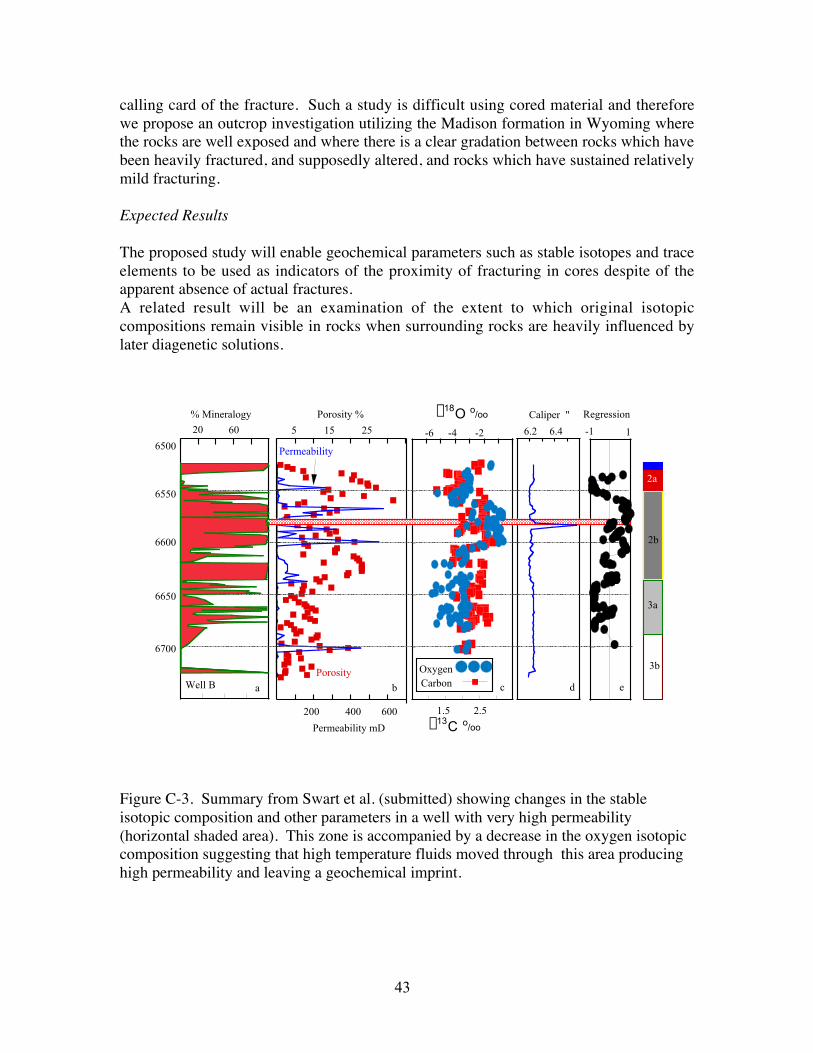
We have proposed that when fractures and concomitant fluids influence a reservoircausing changes in porosity or permeability, that evidence of this process will be visiblewithin the geochemistry of the rock body. For example, if an early formed dolomite witha relatively positive oxygen isotopic composition might be later influence by fracturingwhich brings with it warmer fluids which cause leaching, precipitation, and/ordolomitization. Such events would be recognized by a more negative oxygen isotopiccomposition and perhaps trace element concentrations representative of the fluids movingthrough the fractures. Such a mechanism was proposed for the formation of theenormously permeable super-K zone found within the Arab-D (Swart et al., submitted)(Figure C-3).
The question which we wish to pursue in the next year is the extent to which fracturingcan influence the geochemical composition of a carbonate reservoir thereby leaving a
43
calling card of the fracture. Such a study is difficult using cored material and thereforewe propose an outcrop investigation utilizing the Madison formation in Wyoming wherethe rocks are well exposed and where there is a clear gradation between rocks which havebeen heavily fractured, and supposedly altered, and rocks which have sustained relativelymild fracturing.
Expected Results
The proposed study will enable geochemical parameters such as stable isotopes and traceelements to be used as indicators of the proximity of fracturing in cores despite of theapparent absence of actual fractures.A related result will be an examination of the extent to which original isotopiccompositions remain visible in rocks when surrounding rocks are heavily influenced bylater diagenetic solutions.
Figure C-3. Summary from Swart et al. (submitted) showing changes in the stableisotopic composition and other parameters in a well with very high permeability(horizontal shaded area). This zone is accompanied by a decrease in the oxygen isotopiccomposition suggesting that high temperature fluids moved through this area producinghigh permeability and leaving a geochemical imprint.
% Mineralogy
20 60
2a
2b
3a
3b
Porosity %
Permeability
Porosity
5 25
400200 600
6.2 6.4
Caliper "
-6 -4 -2
1.5 2.5
Depth (ft)
6550
6600
6650
6700
6500
Well B
15 -1 1
Regression
b ca d e
OxygenCarbon
d18O o/oo
Permeability mD d13C o/oo

44
D. Projects in Preparation – pending external support
Energy Fluxes and Anatomy of Deep-Water Coral Mounds
Mark Grasmueck, Gregor Eberli, Peter Swart
PROJECT PURPOSE:
Morphology and distribution of present-day deep-water coral reefs: a modern analog fordeep-water reservoir facies.
SCOPE OF WORK:
High-resolution acoustic imaging and mapping of potential coral mound structures.
PROJECT DESCRIPTIONS:
Rationale and Objectives
Extensive deep-water coral mound communities live in all oceans in total darkness atseveral hundred meters depth in cold water. It is likely that they are more spatiallyabundant than their shallow tropical reef counterparts. Very little is known about thesethriving deep-water communities. Also in the geologic record they have been very rarelydescribed. Chances are that a multitude of fossil deep-water coral accumulations havebeen interpreted as indicators of shallow, tropical paleo-environments. Fossil deepwatercoral structures could form substantial hydrocarbon reservoirs. Some present day deep-water coral mounds have been associated with hydrocarbon seepage as an energy source.Energy fluxes both from the ocean water and the subsurface must be the fundamentalcontrols of communities in these extreme living conditions.
Approach
In the Florida Straits such deep-water communities have been observed in multiplelocations. A comprehensive interdisciplinary study of a living mound field is needed.This will involve extensive surveying of currents, seafloor and the subsurface inunprecedented detail leading into a multi-year and multi-million dollar project. Pendingfunding (NOAA), we will take a three-phased approach for this large undertaking:
• Exploratory Phase: Verification of a living mound province through a line grid ofsonar soundings and video recordings of the living communities.
• Mapping Phase: Detailed current, seafloor topography and 3-D subsurfacesurveying.
• In-situ Observation and Sampling Phase: Focused biological, chemical andecological analysis at critical locations to track the energy fluxes. 3-D sonarimaging of internal anatomy of living mounds.

45
Contact Information
Gregor P. [email protected](305) 361 4678
Comparative Sedimentology LaboratoryRSMAS / MGGUniversity of Miami4600 Rickenbacker CausewayMiami, Florida 33149
Mark P. [email protected](305) 361 4858
Donald F. [email protected](305) 361 4790
Gene [email protected](305) 361 4690
Peter K. [email protected](305) 361 4103
Karen J. [email protected](305) 361 4684
Websitehttp://mgg.rsmas.miami.edu/groups/csl/index.htm