Embed Size (px)
Citation preview

© 2010 Minnesota DNR • MinnAqua • USFWS Sport Fish Restoration
Chapter 3 • Lesson 3
Wonderful WatershedsA river or lake is not isolated. The entire valley is reflected in its waters. It’s part of a system: the watershed.
©MN DNR

© 2010 Minnesota DNR • MinnAqua • USFWS Sport Fish Restoration
3:3-B Chapter 3 • Lesson 3 • Wonder ful Watersheds
Table of Contents
Wonderful Watersheds ..........................................................3:3-A
Minnesota Academic Standards ............................................... 3:3-C
Environmental Literacy Scope and Sequence .......................... 3:3-D
Instructor’s Background Information ...................................3:3-1-12
Summary ................................................................................... 3:3-1
Student Objectives .................................................................... 3:3-1
Materials ................................................................................... 3:3-2
Procedure ................................................................................. 3:3-12
Activity .................................................................................... 3:3-12
Assessment Options ................................................................ 3:3-16
Checklist .............................................................................. 3:3-17
Scoring Rubric ..................................................................... 3:3-18
Extensions ............................................................................... 3:3-19
K-2 Option .............................................................................. 3:3-20
Watershed Model Sheet .......................................................... 3:3-21
Chapter 3 • Lesson 3 • Wonder ful Watersheds 3:3-C
© 2010 Minnesota DNR • MinnAqua • USFWS Sport Fish Restoration
Chapter 3 • Lesson 3
Wonderful Watersheds
Minnesota Academic Standards Lesson introduces this Benchmark. Lesson partially addresses this Benchmark. Lesson fully addresses this Benchmark.
Language Arts
Grades 3, 4, 5I. Reading and LiteratureB. Vocabulary Expansion: Benchmark 1—The student will acquire, understand and use new vocabulary through explicit instruction and independent reading. III. Speaking, Listening, and ViewingA. Speaking and Listening Benchmark 1—The student will participate in and follow agreed-upon rules for conversation and formal discussion in large and small groups.
MathAlignment to the 2007 Minnesota Academic Math Standards coming soon.
Grade 3 V. Spatial Sense, Geometry, and Measurement C. Measurement: Benchmark 1—The student will identify lines of symmetry in geometric shapes. (Identify direction water will flow in a watershed).
History and Social Studies
Grades K – 3V. Geography A. Concept of Location: Benchmark 2—Students will use maps and globes to locate places referenced in stories and real life situations.
Benchmark 4—Students will name and use directional words to describe locations of places in the school and community. Students will locate places by using simple maps, and understand that maps are drawings of locations and places as viewed from above. B. Maps and Globes: Benchmark 1—Students will locate places by using simple maps and understand that maps are drawings of places as viewed from above. C. Physical Features and Processes: Benchmark 2—Students will explain and use introductory geographical terms.
Grades 4 – 8II. Minnesota HistoryG. Post-World War II to the Present: Benchmark 4—Students will identify and describe significant land use changes in Minnesota, issues related to land use, and analyze the impact of those changes and issues. V. Geography C. Physical Features and Processes: Benchmark 2—Students will describe and locate major physical features in their local community and analyze their impact on the community. D. Interconnections: Benchmark 2— Students will analyze how the physical environment influences human activities. D. Interconnections:Benchmark 1— Students will recognize changes over time in nearby landscapes, resulting from human occupation.
© 2010 Minnesota DNR • MinnAqua • USFWS Sport Fish Restoration
3:3-D Chapter 3 • Lesson 3 • Wonder ful Watersheds
Science
Grade 3I. History and Nature of ScienceA. Scientific World View Benchmark 1—The student will explore the use of science as a tool that can help investigate and answer questions about the environment. B. Scientific Inquiry Benchmark 2—The student will participate in a scientific investigation using appropriate tools. IV. Life Science C. Interdependence of Life Benchmark 2—The student will know that changes in a habitat can be beneficial or harmful to an organism.
Grade 4I. History and Nature of ScienceA. Scientific World View:Benchmark 1—The student will explore the uses and effects of science in our interaction with the natural world. Benchmark 2—The student will discuss the responsible use of science. Benchmark 3—The student will recognize that evidence and logic are necessary to support scientific understandings. III. Earth and Space ScienceA. Earth Structure and Processes:Benchmark 1—The student will identify and investigate environmental issues and potential solutions. B. The Water Cycle, Weather and Climate: Benchmark 1—The student will describe the water cycle involving the processes of evaporation, condensation, precipitation and collection. Benchmark 2—The student will identify where water exists on earth.
Grade 5III. Earth and Space ScienceA. Earth Structure and Processes:Benchmark 3—The student will describe how waves, wind, water and ice shape and reshape the Earth’s surface. Benchmark 5—The student will explore the interaction of the lithosphere, atmosphere, biosphere, hydrosphere and space.
Environmental Literacy Scope and Sequence Benchmarks• Socialandnaturalsystemsaremadeofparts.
(PreK-2)• Socialandnaturalsystemsmaynotcontinue
to function if some of their parts are missing. (PreK-2)
• Whenthepartsofsocialandnaturalsystemsareput together, they can do things they couldn’t do by themselves. (PreK-2)
• Insocialandnaturalsystemsthatconsistofmany parts, the parts usually influence one another. (3-5)
• Socialandnaturalsystemsmaynotfunctionaswell if parts are missing, damaged, mismatched or misconnected. (3-5)
For the full Environmental Literacy Scope and Sequence, see: www.seek.state.mn.us/eemn_c.cfm
Chapter 3 • Lesson 3 • Wonder ful Watersheds 3:3-1
© 2010 Minnesota DNR • MinnAqua • USFWS Sport Fish Restoration
Chapter 3 • Lesson 3
Wonderful WatershedsGrade Level: 3-5 Activity Duration: one or two class periodsGroup Size: anySubject Areas: Language Arts, Science, Social Studies, Expressive ArtsAcademic Skills: comparison, experimentation, modeling, observation, recording data Setting: indoor or outdoor gathering area with tablesVocabulary: best management practices, erosion, groundwater, nonpoint source pollution, percolation, point source pollution, ridgelines, riparian habitat, surface runoff, water pollution, watershedInternet Search Words: land use practices, nonpoint source pollution, point source pollution, riparian zone, watershed, watershed education, watershed outreach
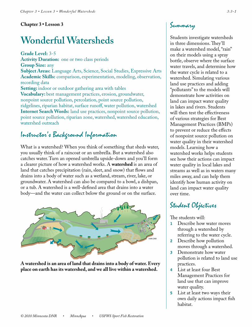
Instructor’s Background InformationWhat is a watershed? When you think of something that sheds water, you usually think of a raincoat or an umbrella. But a watershed also catches water. Turn an opened umbrella upside-down and you’ll form a clearer picture of how a watershed works. A watershed is an area of land that catches precipitation (rain, sleet, and snow) that flows and drains into a body of water such as a wetland, stream, river, lake, or groundwater. A watershed can also be compared to a bowl, a dishpan, or a tub. A watershed is a well-defined area that drains into a water body—and the water can collect below the ground or on the surface.
©MN DNR
A watershed is an area of land that drains into a body of water. Every place on earth has its watershed, and we all live within a watershed.
SummaryStudents investigate watersheds in three dimensions. They’ll make a watershed model, “rain” on their models using a spray bottle, observe where the surface water travels, and determine how the water cycle is related to a watershed. Simulating various land use practices and adding “pollutants” to the models will demonstrate how activities on land can impact water quality in lakes and rivers. Students will then test the effectiveness of various strategies for Best Management Practices (BMPs) to prevent or reduce the effects of nonpoint source pollution on water quality in their watershed models. Learning how a watershed works helps students see how their actions can impact water quality in local lakes and streams as well as in waters many miles away, and can help them identify how human activity on land can impact water quality over time.
Student ObjectivesThe students will: 1 Describe how water moves
through a watershed by referring to the water cycle.
2 Describe how pollution moves through a watershed.
3 Demonstrate how water pollution is related to land use practices.
4 List at least four Best Management Practices for land use that can improve water quality.
5 List at least two ways their own daily actions impact fish habitat.
© 2010 Minnesota DNR • MinnAqua • USFWS Sport Fish Restoration
3:3-2 Chapter 3 • Lesson 3 • Wonder ful Watersheds
There are a variety of effective substitutes for these items. Ask parents or volunteers to provide some of the everyday items. Take students outside to collect leaves, small rocks, grass clippings, litter, soil, small twigs, and other materials for their watershed models.
If each student will be making their own model, provide materials for each student. As an alternative, you can have three or four students work as a group—they can then share the materials. Ask the students to measure and use the necessary materials.
As an alternative to using aluminum foil and the underlying materials, you can use a mixture of plaster, sand, and rocks to mould the watershed topography in the bottoms of the boxes or roasting pans.
Materials • Watershed Model Sheet
to project on a screen or interactive whiteboard or distribute
• Scissors• Plastic storage boxes, foil
roasting pans, or cardboard boxes (lined with plastic); students may bring these from home
• Heavy aluminum foil, three-foot-long sheets
• Rocks (various sizes), crumpled paper balls, small boxes or containers, or dense clay soil—place in bottom of the boxes or pans (under the foil) to form hills and valleys (watershed topography)
• Small toy buildings, vehicles, building blocks, farm animals, model trees, or other items—use these to build model communities
• Light-colored cellulose sponges cut into half-inch-thick strips, enough for several strips for each student or group
• Light-colored felt approximately six inches square, one per student or group
• Scissors, one per student or group
• Brightly-colored unsweetened powdered drink mix, three different colors, one teaspoon per color
• Watercolor paint set and brush
• Food coloring, several drops• Sand or sediment, dirt, or
dried coffee grounds, one tablespoon
• Cocoa powder or powdered ice tea, one tablespoon
• Colored sugar, one tablespoon • Vegetable oil, one teaspoon • Leaves, grass clippings (short
lengths), chocolate sprinkles, parsley flakes, dried basil flakes, or small paper scraps, two tablespoons of each
• Small plastic bags to hold each dry “pollutant”
• Spray bottle filled with water • Newspapers for covering
work areas• Paper towels• Bucket of water or access
to sink• Science notebook• Pencils or pens
Chapter 3 • Lesson 3 • Wonder ful Watersheds 3:3-3
© 2010 Minnesota DNR • MinnAqua • USFWS Sport Fish Restoration
Everyone lives within a watershed. Schoolyards, backyards, farmyards, parking lots, homes, neighborhoods, towns, and cities are part of a watershed. If you travel anywhere, you’re in a watershed. Most of us drink water that comes from somewhere within a local watershed, and we all depend on the quality of our local water. Although people in rural areas often draw their water supply from local wells (groundwater), public water supply systems (drawn from surface water or groundwater) are more prevalent in urban towns and cities. In the United States, most people receive drinking water from groundwater sources. And wildlife, especially fish, depends on the quality of our lakes, rivers, and streams, too!
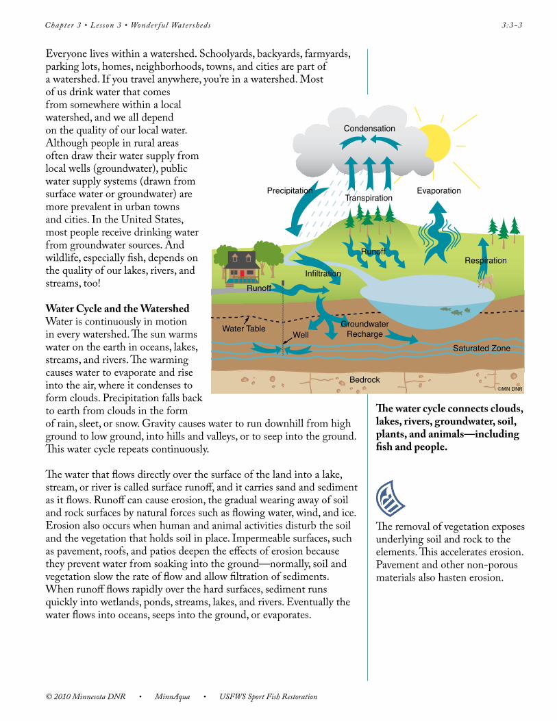
Water Cycle and the Watershed Water is continuously in motion in every watershed. The sun warms water on the earth in oceans, lakes, streams, and rivers. The warming causes water to evaporate and rise into the air, where it condenses to form clouds. Precipitation falls back to earth from clouds in the form of rain, sleet, or snow. Gravity causes water to run downhill from high ground to low ground, into hills and valleys, or to seep into the ground. This water cycle repeats continuously.
The water that flows directly over the surface of the land into a lake, stream, or river is called surface runoff, and it carries sand and sediment as it flows. Runoff can cause erosion, the gradual wearing away of soil and rock surfaces by natural forces such as flowing water, wind, and ice. Erosion also occurs when human and animal activities disturb the soil and the vegetation that holds soil in place. Impermeable surfaces, such as pavement, roofs, and patios deepen the effects of erosion because they prevent water from soaking into the ground—normally, soil and vegetation slow the rate of flow and allow filtration of sediments. When runoff flows rapidly over the hard surfaces, sediment runs quickly into wetlands, ponds, streams, lakes, and rivers. Eventually the water flows into oceans, seeps into the ground, or evaporates.
The water cycle connects clouds, lakes, rivers, groundwater, soil, plants, and animals—including fish and people.
Condensation
TranspirationPrecipitation
Runoff
Water TableWell
GroundwaterRecharge
Infiltration
Saturated Zone
Bedrock
Runoff
Evaporation
Respiration
©MN DNR
The removal of vegetation exposes underlying soil and rock to the elements. This accelerates erosion. Pavement and other non-porous materials also hasten erosion.
© 2010 Minnesota DNR • MinnAqua • USFWS Sport Fish Restoration
3:3-4 Chapter 3 • Lesson 3 • Wonder ful Watersheds
Some of the precipitation that falls to earth seeps directly into the soil. This process is known as percolation or infiltration. Water seeps down through the soil and into groundwater aquifers. Aquifers are sand, gravel, or rock formations below the earth’s surface—they’re porous and saturated with water. The water within an aquifer’s cracks and porous materials is known as groundwater. The water obtained from many wells is groundwater from an aquifer. Groundwater may eventually resurface in a spring, and flow into a nearby water body. Water is always moving—this means that water bodies aren’t isolated. They’re part of a larger system: a watershed. The water cycle, in turn, connects all the elements and water bodies of a watershed, including groundwater, tiny streams, and large rivers.
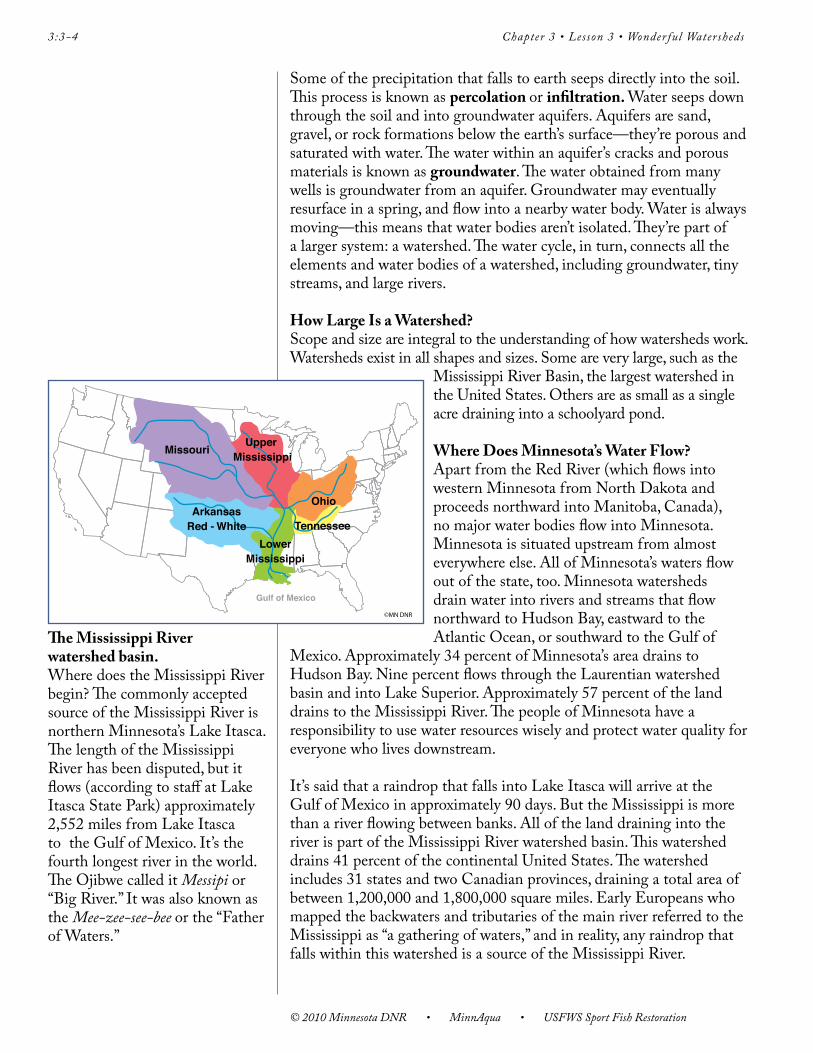
How Large Is a Watershed?Scope and size are integral to the understanding of how watersheds work. Watersheds exist in all shapes and sizes. Some are very large, such as the
Mississippi River Basin, the largest watershed in the United States. Others are as small as a single acre draining into a schoolyard pond.
Where Does Minnesota’s Water Flow?Apart from the Red River (which flows into western Minnesota from North Dakota and proceeds northward into Manitoba, Canada), no major water bodies flow into Minnesota. Minnesota is situated upstream from almost everywhere else. All of Minnesota’s waters flow out of the state, too. Minnesota watersheds drain water into rivers and streams that flow northward to Hudson Bay, eastward to the Atlantic Ocean, or southward to the Gulf of
Mexico. Approximately 34 percent of Minnesota’s area drains to Hudson Bay. Nine percent flows through the Laurentian watershed basin and into Lake Superior. Approximately 57 percent of the land drains to the Mississippi River. The people of Minnesota have a responsibility to use water resources wisely and protect water quality for everyone who lives downstream.
It’s said that a raindrop that falls into Lake Itasca will arrive at the Gulf of Mexico in approximately 90 days. But the Mississippi is more than a river flowing between banks. All of the land draining into the river is part of the Mississippi River watershed basin. This watershed drains 41 percent of the continental United States. The watershed includes 31 states and two Canadian provinces, draining a total area of between 1,200,000 and 1,800,000 square miles. Early Europeans who mapped the backwaters and tributaries of the main river referred to the Mississippi as “a gathering of waters,” and in reality, any raindrop that falls within this watershed is a source of the Mississippi River.
Gulf of Mexico
Upper Mississippi
LowerMississippi
ArkansasRed - White Tennessee
Missouri
Ohio
©MN DNR
The Mississippi River watershed basin. Where does the Mississippi River begin? The commonly accepted source of the Mississippi River is northern Minnesota’s Lake Itasca. The length of the Mississippi River has been disputed, but it flows (according to staff at Lake Itasca State Park) approximately 2,552 miles from Lake Itasca to the Gulf of Mexico. It’s the fourth longest river in the world. The Ojibwe called it Messipi or “Big River.” It was also known as the Mee-zee-see-bee or the “Father of Waters.”
Chapter 3 • Lesson 3 • Wonder ful Watersheds 3:3-5
© 2010 Minnesota DNR • MinnAqua • USFWS Sport Fish Restoration
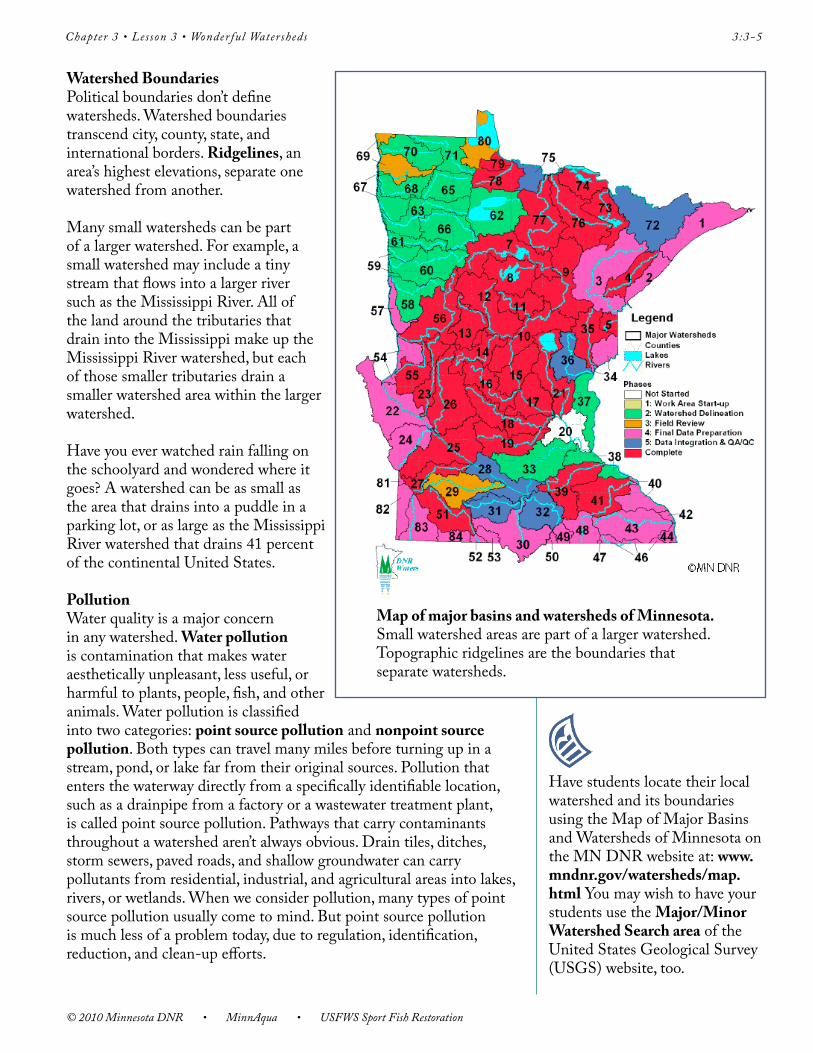
Watershed BoundariesPolitical boundaries don’t define watersheds. Watershed boundaries transcend city, county, state, and international borders. Ridgelines, an area’s highest elevations, separate one watershed from another.
Many small watersheds can be part of a larger watershed. For example, a small watershed may include a tiny stream that flows into a larger river such as the Mississippi River. All of the land around the tributaries that drain into the Mississippi make up the Mississippi River watershed, but each of those smaller tributaries drain a smaller watershed area within the larger watershed.
Have you ever watched rain falling on the schoolyard and wondered where it goes? A watershed can be as small as the area that drains into a puddle in a parking lot, or as large as the Mississippi River watershed that drains 41 percent of the continental United States.
Pollution Water quality is a major concern in any watershed. Water pollution is contamination that makes water aesthetically unpleasant, less useful, or harmful to plants, people, fish, and other animals. Water pollution is classified into two categories: point source pollution and nonpoint source pollution. Both types can travel many miles before turning up in a stream, pond, or lake far from their original sources. Pollution that enters the waterway directly from a specifically identifiable location, such as a drainpipe from a factory or a wastewater treatment plant, is called point source pollution. Pathways that carry contaminants throughout a watershed aren’t always obvious. Drain tiles, ditches, storm sewers, paved roads, and shallow groundwater can carry pollutants from residential, industrial, and agricultural areas into lakes, rivers, or wetlands. When we consider pollution, many types of point source pollution usually come to mind. But point source pollution is much less of a problem today, due to regulation, identification, reduction, and clean-up efforts.
Have students locate their local watershed and its boundaries using the Map of Major Basins and Watersheds of Minnesota on the MN DNR website at: www.mndnr.gov/watersheds/map.html You may wish to have your students use the Major/Minor Watershed Search area of the United States Geological Survey (USGS) website, too.
© 2010 Minnesota DNR • MinnAqua • USFWS Sport Fish Restoration
3:3-6 Chapter 3 • Lesson 3 • Wonder ful Watersheds
Nonpoint source pollution comes from sources whose locations aren’t easily pinpointed. Nonpoint source pollution occurs due to water’s continuous motion. As rainfall and snowmelt move over and through the ground, the runoff picks up and carries natural and human-made pollutants. Nonpoint source pollution can also travel long distances in the air and fall to earth in precipitation, such as in the case of acid rain. Nonpoint source pollution is difficult to measure and challenging to regulate and control. This form of pollution is widespread. It results from a variety of human activities on land.
Sources of nonpoint source pollution include the following: • pesticides,herbicides,andnutrients,suchasphosphorousand
nitrogen, from fertilizers applied to agricultural lands and commercial and residential areas
• detergents(manydishwashingdetergentscontainphosphorous)• grassclippingsandleaves• chemicalsresultingfromenergyproduction• enginedrippings,suchasoil,gas,grease;heavymetalsfromvehicle
tire and brake pad wear• salt,fromirrigationpracticesandwinterroadsalt• siltandsedimentfromdisturbedgroundatconstructionsites,
agricultural fields, forested lands, culverts, and eroding stream banks • nutrientsandbacteria,suchasfecalcoliform,frompetandlivestock
wastes and faulty septic systems• airbornepollution,includingacidrainanddustparticles
People’s activities definitely have repercussions that affect water, plants, people, fish, and other animals. The effects often occur far beyond the locales where these activities take place.
Land Use PracticesEvery activity in the watershed affects water quality. As the population in a watershed increases, human impact increases. Over time, this can affect water quality, in both negative and positive ways.
People often harm water quality by applying excessive amounts of fertilizers to lawns (or apply them just before it rains) or apply fertilizers near wetlands and storm sewers. Fertilizers travel in surface runoff, flowing through storm sewers and into nearby wetlands, lakes, or rivers. The nutrients in the fertilizer (such as phosphorus) spark the growth of algae. These large amounts of algae eventually die and, as bacterial decomposers go to work, they consume the dissolved oxygen that fish and other aquatic organisms need to survive.
Other examples of harmful land use practices include:• incorrectlyinstalledormaintainedsiltfencesatconstructionsites
result in excessive erosion or runoff• alteringawatershed’snaturalwaterflow• improperdisposaloftoxicmaterialssuchaspaint,batteries,and
Chapter 3 • Lesson 3 • Wonder ful Watersheds 3:3-7
© 2010 Minnesota DNR • MinnAqua • USFWS Sport Fish Restoration
household chemicals• dumpingusedoil,leavesandgrassclippings,andcarwashing
detergents into storm sewers• failingtopickupandproperlydiscardpetwastes• improperuseandexcessiveapplicationoffertilizers,
herbicides, and pesticides• inadequatedetentionorcontainmentofrunofffromimpervious
surfaces, such as pavement and rooftops
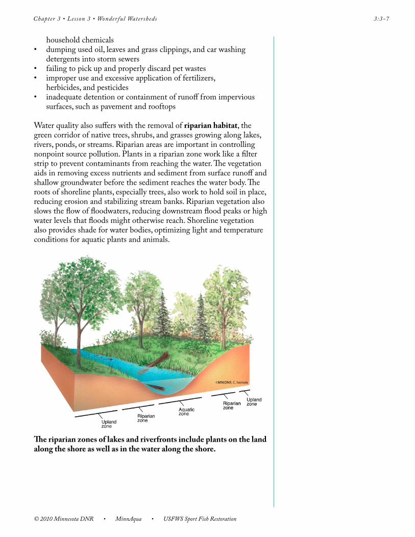
Water quality also suffers with the removal of riparian habitat, the green corridor of native trees, shrubs, and grasses growing along lakes, rivers, ponds, or streams. Riparian areas are important in controlling nonpoint source pollution. Plants in a riparian zone work like a filter strip to prevent contaminants from reaching the water. The vegetation aids in removing excess nutrients and sediment from surface runoff and shallow groundwater before the sediment reaches the water body. The roots of shoreline plants, especially trees, also work to hold soil in place, reducing erosion and stabilizing stream banks. Riparian vegetation also slows the flow of floodwaters, reducing downstream flood peaks or high water levels that floods might otherwise reach. Shoreline vegetation also provides shade for water bodies, optimizing light and temperature conditions for aquatic plants and animals.
The riparian zones of lakes and riverfronts include plants on the land along the shore as well as in the water along the shore.
© 2010 Minnesota DNR • MinnAqua • USFWS Sport Fish Restoration
3:3-8 Chapter 3 • Lesson 3 • Wonder ful Watersheds
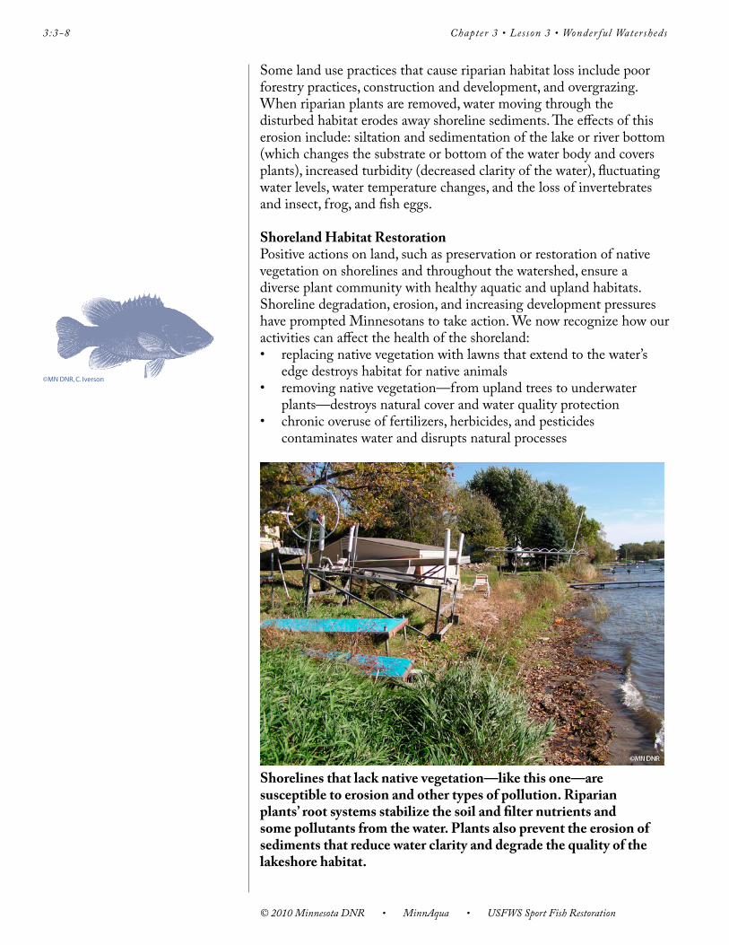
Some land use practices that cause riparian habitat loss include poor forestry practices, construction and development, and overgrazing. When riparian plants are removed, water moving through the disturbed habitat erodes away shoreline sediments. The effects of this erosion include: siltation and sedimentation of the lake or river bottom (which changes the substrate or bottom of the water body and covers plants), increased turbidity (decreased clarity of the water), fluctuating water levels, water temperature changes, and the loss of invertebrates and insect, frog, and fish eggs.
Shoreland Habitat RestorationPositive actions on land, such as preservation or restoration of native vegetation on shorelines and throughout the watershed, ensure a diverse plant community with healthy aquatic and upland habitats. Shoreline degradation, erosion, and increasing development pressures have prompted Minnesotans to take action. We now recognize how our activities can affect the health of the shoreland: • replacingnativevegetationwithlawnsthatextendtothewater’s
edge destroys habitat for native animals• removingnativevegetation—fromuplandtreestounderwater
plants—destroys natural cover and water quality protection• chronicoveruseoffertilizers,herbicides,andpesticides
contaminates water and disrupts natural processes
Shorelines that lack native vegetation—like this one—are susceptible to erosion and other types of pollution. Riparian plants’ root systems stabilize the soil and filter nutrients and some pollutants from the water. Plants also prevent the erosion of sediments that reduce water clarity and degrade the quality of the lakeshore habitat.
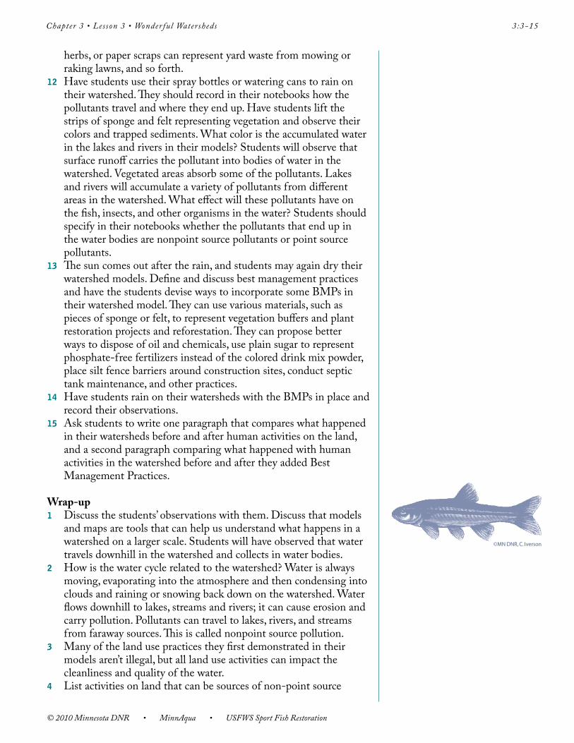
©MN DNR, C. Iverson
Chapter 3 • Lesson 3 • Wonder ful Watersheds 3:3-9
© 2010 Minnesota DNR • MinnAqua • USFWS Sport Fish Restoration
Fortunately, people have an opportunity to affect positive change. The Restore Your Shore PowerPoint presentation on CD, available through the Minnesota DNR Resources, guides property owners through the process of protecting a natural shoreline or restoring a degraded one with a natural buffer zone. The popular book, Lakescaping for Wildlife and Water Quality, by Carrol Henderson (Minnesota DNR nongame wildlife specialist), Carolyn Dindorf (award-winning soil and water conservationist), and Fred Rozumalski (highly acclaimed landscape ecologist), provided a catalyst to the Minnesota DNR’s lakescaping initiatives.
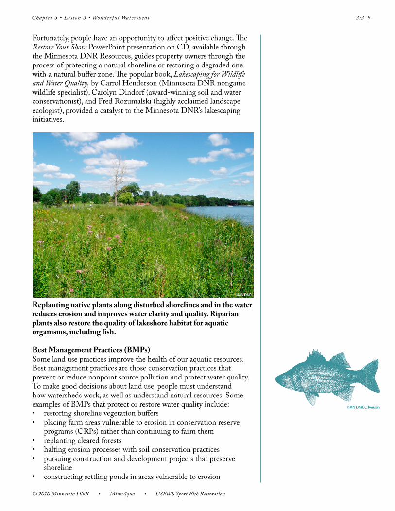
Replanting native plants along disturbed shorelines and in the water reduces erosion and improves water clarity and quality. Riparian plants also restore the quality of lakeshore habitat for aquatic organisms, including fish.
Best Management Practices (BMPs)Some land use practices improve the health of our aquatic resources. Best management practices are those conservation practices that prevent or reduce nonpoint source pollution and protect water quality. To make good decisions about land use, people must understand how watersheds work, as well as understand natural resources. Some examples of BMPs that protect or restore water quality include: • restoringshorelinevegetationbuffers• placingfarmareasvulnerabletoerosioninconservationreserve
programs (CRPs) rather than continuing to farm them• replantingclearedforests• haltingerosionprocesseswithsoilconservationpractices• pursuingconstructionanddevelopmentprojectsthatpreserve
shoreline • constructingsettlingpondsinareasvulnerabletoerosion
©MN DNR, C. Iverson
© 2010 Minnesota DNR • MinnAqua • USFWS Sport Fish Restoration
3:3-10 Chapter 3 • Lesson 3 • Wonder ful Watersheds
• fencinglivestocktopreventaccesstostreamsandlakes,wheretheytrample riparian vegetation and increase erosion
• implementingregularseptictankmaintenance• keepingwaste,suchasusedautomotiveoil,outofstormsewers• baggingorcompostingleavesandgrassclippingsratherthanraking
them into storm sewers • recyclingusedmotoroil• usingphosphate-freefertilizers• reducingtheuseoftoxichouseholdchemicals• reducingtheuseofdishwasherdetergentscontainingphosphorous• reducingtheamountofimpervioussurfacesonprivateandpublic
property• erectingsiltfencingatdisturbedareas• replantingareasofexposedsoilwithnativevegetationasquicklyas
possible after disturbance• placinglandinconservationeasementsortrustsandrestricting
deeds so that, when a property is sold, only environmentally-friendly land use activities are allowed on that land
• and,ofcourse,waterconservation—usinglesswaterinour everyday lives
The list of best management practices continues to grow and improve. In the 2002 session of the Minnesota Legislature, state law was amended to include the regulation of phosphorous content in lawn fertilizers applied within the state. The current law prohibits the application of fertilizers containing phosphorus within the metropolitan counties, and limits to three percent by weight (for solids) or 0.3 pound per 1,000 square foot (for liquids) the amount of phosphate in fertilizers applied in the rest of the state (Minn. Stat. Chapter 18C).
City planners and developers should consider including areas of pervious, or permeable, surface instead of concrete or asphalt pavement whenever possible. A permeable surface lets rainwater soak through to the ground, reducing the amount of water that enters storm sewers by way of nonporous surfaces such as roads, parking lots, and roofs. Some examples of pervious surfaces include: rain gardens, forests, lawns, green space, green roofs, and parkland. A rain garden is a landscape depression with loose soil, planted densely with flowers, grasses, or shrubs. Storm water runoff from driveways, roofs, and sidewalks is directed into the rain garden, where it’s used by plants or seeps into the soil.
A green roof (or garden roof ) is an engineered roof system that uses a lightweight soil mixture and plants as final cover rather than shingles or asphalt. Rainwater falling on a green roof is held in the soil or taken up by plants, reducing the volume of storm water entering lakes and rivers. Road builders deflect water from impervious surfaces by installing water bars—small, raised ridges on the road surface that deflect water flow into ditches.
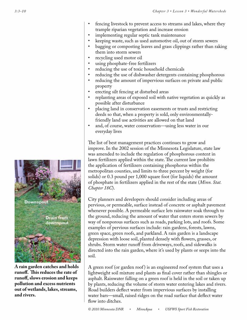
A rain garden catches and holds runoff. This reduces the rate of runoff, slows erosion and keeps pollution and excess nutrients out of wetlands, lakes, streams, and rivers.

Chapter 3 • Lesson 3 • Wonder ful Watersheds 3:3-11
© 2010 Minnesota DNR • MinnAqua • USFWS Sport Fish Restoration
Tradeoffs must often be considered in decisions to implement BMPs. Short-term monetary costs must be balanced against the potential long-term costs of degraded water quality in the watershed.
BMPs also include old-fashioned water conservation methods. Rain barrels collect roof runoff from gutters before it can carry sediment and contaminants into lakes and streams, and the rainwater can be used to water flowers and vegetable gardens. Barrels are available commercially or can be made from food grade scrap or wooden barrels. Using less water in everyday activities is important, too. Freshwater is a limited resource that plays a large role in the health of a watershed. (See Lesson 3:4—Would You Drink This Water?) Runoff that flows into storm sewers doesn’t go to water treatment facilities. It flows directly into lakes and rivers. It’s important to remember that it’s expensive—and not always possible—to clean the polluted water that flows to water treatment plants. Keeping water clean by not polluting it in the first place is a much more cost-effective way to protect water quality.
Managing Water ResourcesCommunities across Minnesota have recognized that they must work at the watershed level to solve their diverse water resource issues. Boards of Soil and Water Conservation Districts, Watershed Districts, and the Minnesota DNR work with communities throughout Minnesota using similar basic management tools to mitigate the impacts of development and various other land use practices on water quality: watershed planning, land conservation, aquatic buffers, improved site design, erosion control, wastewater treatment, control of non-stormwater discharge, and watershed stewardship. Depending on an area’s land use practices and watershed characteristics, these basic water resource management tools may be applied in different ways or in different combinations. Together they form the foundation for all water quality projects.
Who Protects the Watershed?As our population continues to grow, and the human footprint on the land becomes larger, it’s even more important to understand that everyone must play a role in protecting water quality in their own watershed, and in neighboring watersheds. Our watershed communities are interconnected, and we all live either upstream or downstream from someone else. We can work with federal, state, and local agencies to reduce and prevent pollution that arises from people’s activities on land. The Minnesota DNR regulates the type and extent of development permitted near shorelines. Counties or municipalities may adopt and enforce restrictive ordinances regarding zoning or erosion control. County governments have responsibilities—ranging from road construction to hazardous waste management—that impact the local watershed. Every citizen can contribute to these efforts by practicing conservation and BMPs at home, and by making informed choices to change everyday habits and activities that impact the watershed.
When a landowner considers putting a piece of property up for sale, alternatives might include placing the land in conservation easements and trusts, or applying restrictions allowing only environmentally-friendly land uses.
© 2010 Minnesota DNR • MinnAqua • USFWS Sport Fish Restoration
3:3-12 Chapter 3 • Lesson 3 • Wonder ful Watersheds
We all share the responsibility for caring for our watersheds and water resources. People can work together to ensure a healthy ecosystem while meeting a community’s needs that includes informed means of development using Best Management Practices, areas of native vegetation, natural shorelines, and clean lakes, rivers, and streams to ensure a healthful quality of life. History has shown that people’s activities on land have indeed impacted our water quality, and we should heed this lesson.
ProcedurePreparation1 Obtain materials needed to create watershed models.
ActivityWarm-up1 Ask students where rain goes after a storm. (Answers should
include: into the ground, storm sewers, lakes, rivers, and evaporation into clouds). Then ask students where the water in a nearby lake, river, or stream (name the water body) came from. Guide students to list rain, snow, storm sewers, water that runs downhill on the land, from springs (groundwater), and rain and snowmelt running down streets and sidewalks. Hold up an umbrella or foil roasting pan to demonstrate and define watershed for the students. You may also use the Watershed Model Sheet to help describe a watershed. Compare the land draining into the local lake, pond, stream or river to an upside-down umbrella, foil roasting pan, tub, or a dishpan. Explain that a watershed is a well-defined area around the water body.
2 Review the water cycle and ask why water is important. Tell students that we all live in a watershed. Where do we get the water that we drink? The water we use every day comes from the watershed where we live. Tell them they will explore how the activities that occur in their watershed affect the quality of the water in the watershed.
3 Have students close their eyes. Ask them to imagine what their neighborhood might have looked like 200 years ago, before there were houses, farms, and cars. Who lived on the land? What kinds of things were people doing on the land in the watershed? What do they think the water in the local lakes and streams was like? Why?
4 With their eyes still closed, ask students to think about their neighborhood today. What does it look like? Who lives on the land? Which human activities occur in the watershed? What do they suppose the water in the local lakes and streams is like today? Why?
5 Have students open their eyes. Have your students brainstorm a list of land use practices that occur in the local watershed. List their ideas on the classroom whiteboard or projection device.
Chapter 3 • Lesson 3 • Wonder ful Watersheds 3:3-13
© 2010 Minnesota DNR • MinnAqua • USFWS Sport Fish Restoration
Lesson1 Pass out materials. If you don’t have enough space or materials for
students to work individually, place students in groups of three or four. If students are working in groups, one group member can gather materials while another fills the water spray bottle or sprinkling can and another covers the work area with newspaper. One student can be designated as the group’s recorder and write down observations.
2 Have each student or group make a three-dimensional (relief ) model of a watershed area surrounding a pond, lake, or stream inside of a plastic-lined box or foil roasting pan. Explain that these watershed models are three-dimensional maps of a watershed. When looking down on the model from above, the viewer can locate various places, land forms, water bodies, and the different ways in which people use land in the watershed.
3 Ask students to think about a watershed from 200 years ago, before modern development. First add the rocks and clay to the container. Place the slightly crumpled foil sheet on top, moulding it over rocks or clay soil mounds, creating relief topography and securing it to the edges of the pan. Be careful not to tear or poke holes into the foil. Tell students the watershed models should include some relief (hills, valleys, plains, fields, lakes, and rivers). Students can use permanent markers, felt, small toys, sand, and other materials to represent vegetated areas, wooded areas, open fields, and other features. Strips of dampened sponges and felt can represent vegetation alongside water bodies and wetlands. Ask students to include at least one lake or river in their watershed models. The instructor can crumple and shape a sheet of foil to demonstrate the procedure, or show a pre-prepared model as an example. Remind the students that watersheds come in many shapes.
4 Now ask students to look at their watersheds and think about their neighborhoods and communities of today. Have them use permanent markers and small toys, and other materials to map out or draw yards, paved areas, roads, parking lots, and any developed areas with buildings, factories, houses, farms, parks, or other places. Have them lightly sprinkle a bit of sand, dirt, or cocoa powder on any open fields, disturbed ground, or paved areas.
©MN DNR, C. Iverson
© 2010 Minnesota DNR • MinnAqua • USFWS Sport Fish Restoration
3:3-14 Chapter 3 • Lesson 3 • Wonder ful Watersheds
5 While the students are creating their watershed models, the instructor should circulate around the classroom to make sure models are being constructed according to directions, and to answer any questions students may have.
6 When models are complete and the instructor has approved the design, students may play the role of clouds and “rain” on their watersheds, using a spray bottle to produce the showers. Before raining on the models, the students should be sure that any wetlands or vegetated areas (sponges or felt) are still damp. Have students pay attention to what happens to their model as they rain on the watershed. They should record in their notebooks where the rain falls, how it moves through the watershed, where it collects, and how the rain affects different areas in the watershed. Discuss the students’ observations with them. Are there differences between what happened in the models? For example, did some models show more erosion (movement of sand or soil) than others? Ask students why this might have happened. (Answers include: some models have more exposed or disturbed land, steep hills, pavement, or sparse vegetation). Did the water collect in certain areas? Where? Why?
7 Define surface runoff. (Surface runoff is water that runs off the land into a water body.) Remind students that water runs downhill. Discuss why surface runoff carries sediments and other pollutants from the land to lakes, rivers, streams, ponds, and wetlands.
8 Define pollution. (Pollution is contamination caused by natural or human-made substances that reduce the useful qualities of any part of the environment’s soil, water, or air.) Is erosion pollution? Define the two categories of pollution: point source and nonpoint source pollution.
9 When students understand how water moves through a watershed, tell students the sun is out, and water is evaporating up into the clouds. Use paper towels to dry the watershed models.
10 Have students introduce some hypothetical human activities on the land (land use practices) to their watershed and describe them in their notebooks (examples might include: a new housing development under construction in the valley, leaky septic systems detected in one part of town, logging in the forest, grass clippings raked into streets after mowing, a neighbor doesn’t pick up and properly dispose of pet waste.)
11 Now students can add “pollutants,” the products of their land use activities, to the appropriate sites on their models. They can use food coloring, watercolor paint, and vegetable oil to represent chemical spills, lawn fertilizer, or oil. They can use colored sugar or packaged drink powder to represent granular fertilizers on farm fields and lawns. They can sprinkle cocoa powder, coffee grounds, or powdered iced tea mix to represent erosion in areas of development or other sites where the ground has been disturbed. They can remove vegetated areas to represent development projects and logging. Chocolate sprinkles can represent waste from pets or livestock. Small leaf pieces, short lengths of grass clippings, dried
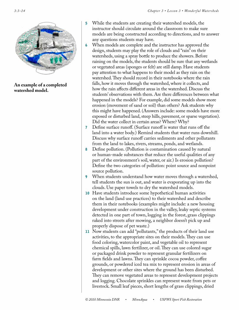
An example of a completed watershed model.
Chapter 3 • Lesson 3 • Wonder ful Watersheds 3:3-15
© 2010 Minnesota DNR • MinnAqua • USFWS Sport Fish Restoration
herbs, or paper scraps can represent yard waste from mowing or raking lawns, and so forth.
12 Have students use their spray bottles or watering cans to rain on their watershed. They should record in their notebooks how the pollutants travel and where they end up. Have students lift the strips of sponge and felt representing vegetation and observe their colors and trapped sediments. What color is the accumulated water in the lakes and rivers in their models? Students will observe that surface runoff carries the pollutant into bodies of water in the watershed. Vegetated areas absorb some of the pollutants. Lakes and rivers will accumulate a variety of pollutants from different areas in the watershed. What effect will these pollutants have on the fish, insects, and other organisms in the water? Students should specify in their notebooks whether the pollutants that end up in the water bodies are nonpoint source pollutants or point source pollutants.
13 The sun comes out after the rain, and students may again dry their watershed models. Define and discuss best management practices and have the students devise ways to incorporate some BMPs in their watershed model. They can use various materials, such as pieces of sponge or felt, to represent vegetation buffers and plant restoration projects and reforestation. They can propose better ways to dispose of oil and chemicals, use plain sugar to represent phosphate-free fertilizers instead of the colored drink mix powder, place silt fence barriers around construction sites, conduct septic tank maintenance, and other practices.
14 Have students rain on their watersheds with the BMPs in place and record their observations.
15 Ask students to write one paragraph that compares what happened in their watersheds before and after human activities on the land, and a second paragraph comparing what happened with human activities in the watershed before and after they added Best Management Practices.
Wrap-up1 Discuss the students’ observations with them. Discuss that models
and maps are tools that can help us understand what happens in a watershed on a larger scale. Students will have observed that water travels downhill in the watershed and collects in water bodies.
2 How is the water cycle related to the watershed? Water is always moving, evaporating into the atmosphere and then condensing into clouds and raining or snowing back down on the watershed. Water flows downhill to lakes, streams and rivers; it can cause erosion and carry pollution. Pollutants can travel to lakes, rivers, and streams from faraway sources. This is called nonpoint source pollution.
3 Many of the land use practices they first demonstrated in their models aren’t illegal, but all land use activities can impact the cleanliness and quality of the water.
4 List activities on land that can be sources of non-point source
©MN DNR, C. Iverson

© 2010 Minnesota DNR • MinnAqua • USFWS Sport Fish Restoration
3:3-16 Chapter 3 • Lesson 3 • Wonder ful Watersheds
pollution. Digging one foundation for a house, or paving one street may not greatly impact a stream or river, but all activities in the watershed can accumulate to impact local water quality. Ask students why we should we worry about pollution that occurs five miles away. Is your neighborhood highly developed or more rural? Where does the rainwater from your schoolyard, local streets, local ponds and rivers, and driveways go? Where does the rainwater from local farms, fields, or forests go? Where does your drinking water come from?
5 What can students do to have a positive impact on water quality in their watershed? (Examples include picking up pet waste, properly disposing of litter, raking leaves from sidewalks and streets, turning off running faucets and hoses, washing bikes or cars on the lawn or another permeable surface rather than in the driveway.) What are Best Management Practices? Which BMPs did they use in their watershed models? Were they effective? In real life, who decides if BMPs will be used? (We all do! )
Assessment Options1 Ask students to write two short paragraphs or to draw two
illustrations. For Paragraph 1 or Drawing 1: define or make a map illustrating a watershed. Describe or show four activities and land use practices occurring in your watershed that can positively or negatively impact water quality in your local pond, lake, or stream. Who depends on good water quality in that water body? Describe how human land use practices have changed in your watershed over time. For Paragraph 2 or Drawing 2: describe or make a map that illustrates two everyday actions (personal BMPs) that you can take to improve water quality in your watershed. Why is it everyone’s responsibility to protect water quality in the watershed?
2 Have students make a poster or map illustrating a healthy watershed where people reside. This can be a watershed they create, or a map of the local watershed. The poster or map should promote good land use practices (BMPs). Tell students their poster or local watershed map will be assessed on the following:• presenceofwaterbodies• arrowsshowingtheflowofwaterinthewatershed,specifically
how this movement relates to the water cycle• inclusionofBestManagementPracticesforlanduseactivities
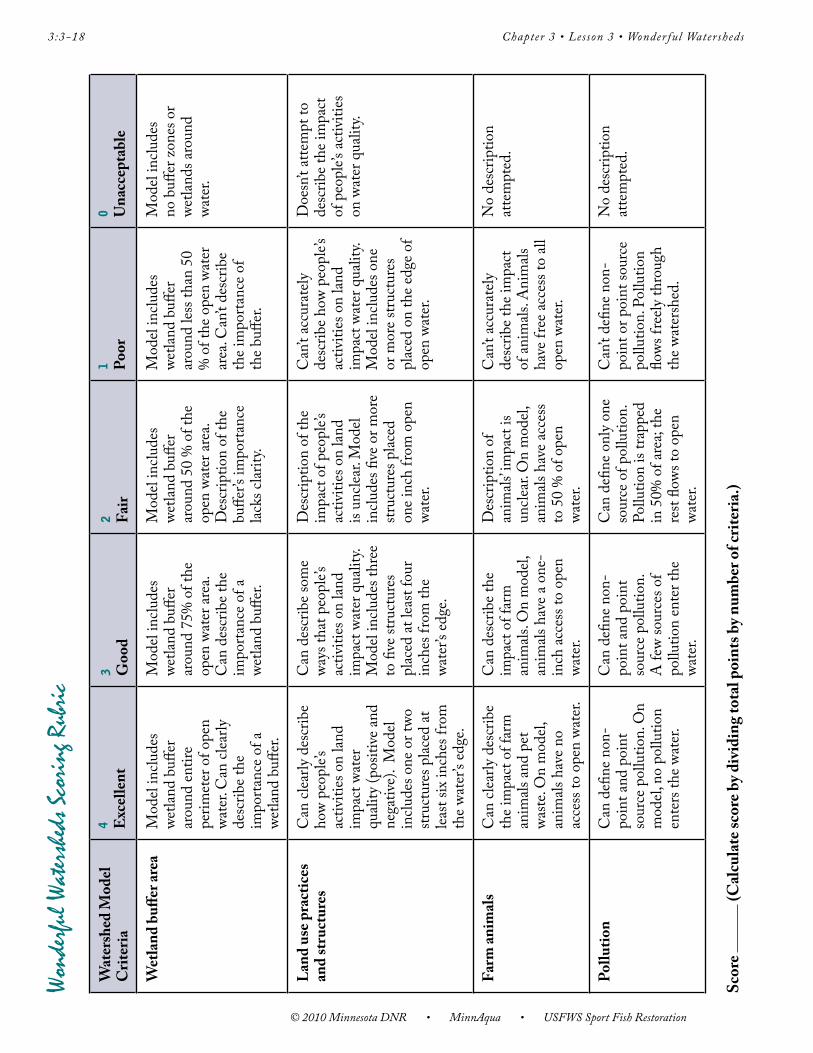
3 Assessment options include the Checklist and Rubric on the following pages.
©MN DNR, C. Iverson

Chapter 3 • Lesson 3 • Wonder ful Watersheds 3:3-17
© 2010 Minnesota DNR • MinnAqua • USFWS Sport Fish Restoration
Wonderful Watersheds ChecklistPossible Points PointsPoints Earned Earned
Student Instructor4 Watershed model includes a wetland
buffer around the entire perimeter of open water.
3 Student can clearly describe the importance of a wetland buffer.
3 Student can clearly describe how people’s activities on land impact water quality.
2 Model includes one or two structures at least six inches from the water’s edge.
3 Student can clearly describe how farm animals and pet waste impact water quality.
2 Model includes no access to open water for farm animals.
2 Student can define non-point pollution and point source pollution.
2 Student can define surface runoff and erosion.
3 Can describe three Best Management Practices (BMPs) for land use.
3 Model with BMPs included prevents pollution from entering water bodies, and allows little or no erosion.
2 Can state two reasons why it’s everyone’s responsibility to protect water quality in their home watershed.
Total Points
29 Score
Checklists are tools for students and instructors. Checklists involve students in managing their own learning. They help students understand and set learning goals before the lesson begins, and help them monitor their progress during the lesson, ensuring that they meet learning goals and objectives by the end of the lesson. Students can also use checklists to discover areas that may need improvement. Checklists help instructors monitor each student’s progress throughout the lesson, facilitating appropriate adjustment of instruction to ensure learning by the end of the lesson. The instructor may wish to have students add several of their own learning goals to the checklist to personalize it, and to accommodate varied learning needs and styles.
Grade
27-29 points = AExcellent. Work is above expectations.
24-26 points = BGood. Work meets expectations.
20-23 points = CWork is generally good. Some areas are better developed than others.
16-19 points = DWork doesn’t meet expectations; it’s not clear that student understands objectives.
0-15 points = FWork is unacceptable.
© 2010 Minnesota DNR • MinnAqua • USFWS Sport Fish Restoration
3:3-18 Chapter 3 • Lesson 3 • Wonder ful Watersheds
Won
derfu
l Wat
ershe
ds S
cori
ng R
ubri
c
Wat
ersh
ed M
odel
Crit
eria
4 E
xcel
lent
3 Goo
d2 Fa
ir1 Po
or0 U
nacc
epta
ble
Wet
land
buff
er ar
eaM
odel
inclu
des
wetla
nd b
uffer
ar
ound
entir
e pe
rimet
er o
f ope
n wa
ter.
Can
clea
rly
desc
ribe t
he
impo
rtanc
e of a
we
tland
buff
er.
Mod
el in
clude
s we
tland
buff
er
arou
nd 7
5% o
f the
op
en w
ater
area
. C
an d
escr
ibe t
he
impo
rtanc
e of a
we
tland
buff
er.
Mod
el in
clude
s we
tland
buff
er
arou
nd 5
0 %
of t
he
open
wat
er ar
ea.
Des
crip
tion
of th
e bu
ffer’s
impo
rtanc
e lac
ks cl
arity
.
Mod
el in
clude
s we
tland
buff
er
arou
nd le
ss th
an 5
0 %
of t
he o
pen
wate
r ar
ea. C
an’t
desc
ribe
the i
mpo
rtanc
e of
the b
uffer
.
Mod
el in
clude
s no
buff
er z
ones
or
wetla
nds a
roun
d wa
ter.
Land
use
pra
ctic
es
and
stru
ctur
esC
an cl
early
des
crib
e ho
w pe
ople
’s ac
tiviti
es o
n lan
d im
pact
wat
er
quali
ty (p
ositi
ve an
d ne
gativ
e).
Mod
el in
clude
s one
or t
wo
struc
ture
s plac
ed at
lea
st six
inch
es fr
om
the w
ater
’s ed
ge.
Can
des
crib
e som
e wa
ys th
at p
eopl
e’s
activ
ities
on
land
impa
ct w
ater
qua
lity.
Mod
el in
clude
s thr
ee
to fi
ve st
ruct
ures
pl
aced
at le
ast f
our
inch
es fr
om th
e wa
ter’s
edge
.
Des
crip
tion
of th
e im
pact
of p
eopl
e’s
activ
ities
on
land
is un
clear
. Mod
el in
clude
s five
or m
ore
struc
ture
s plac
ed
one i
nch
from
ope
n wa
ter.
Can
’t ac
cura
tely
de
scrib
e how
peo
ple’s
ac
tiviti
es o
n lan
d im
pact
wat
er q
ualit
y.
Mod
el in
clude
s one
or
mor
e stru
ctur
es
plac
ed o
n th
e edg
e of
open
wat
er.
Doe
sn’t
atte
mpt
to
desc
ribe t
he im
pact
of
peo
ple’s
activ
ities
on
wat
er q
ualit
y.
Farm
anim
als
Can
clea
rly d
escr
ibe
the i
mpa
ct o
f far
m
anim
als an
d pe
t wa
ste. O
n m
odel,
an
imals
hav
e no
acce
ss to
ope
n wa
ter.
Can
des
crib
e the
im
pact
of f
arm
an
imals
. On
mod
el,
anim
als h
ave a
one
-in
ch ac
cess
to o
pen
wate
r.
Des
crip
tion
of
anim
als’ im
pact
is
uncle
ar. O
n m
odel,
an
imals
hav
e acc
ess
to 5
0 %
of o
pen
wate
r.
Can
’t ac
cura
tely
de
scrib
e the
impa
ct
of an
imals
. Ani
mals
ha
ve fr
ee ac
cess
to al
l op
en w
ater
.
No
desc
riptio
n at
tem
pted
.
Pollu
tion
Can
defi
ne n
on-
poin
t and
poi
nt
sour
ce p
ollu
tion.
On
mod
el, n
o po
llutio
n en
ters
the w
ater
.
Can
defi
ne n
on-
poin
t and
poi
nt
sour
ce p
ollu
tion.
A
few
sour
ces o
f po
llutio
n en
ter t
he
wate
r.
Can
defi
ne o
nly
one
sour
ce o
f pol
lutio
n.
Pollu
tion
is tra
pped
in
50%
of a
rea;
the
rest
flows
to o
pen
wate
r.
Can
’t de
fine n
on-
poin
t or p
oint
sour
ce
pollu
tion.
Pol
lutio
n flo
ws fr
eely
thro
ugh
the w
ater
shed
.
No
desc
riptio
n at
tem
pted
.
Scor
e (C
alcu
late
scor
e by d
ivid
ing
tota
l poi
nts b
y num
ber o
f crit
eria
.)

Chapter 3 • Lesson 3 • Wonder ful Watersheds 3:3-19
© 2010 Minnesota DNR • MinnAqua • USFWS Sport Fish Restoration
Diving Deeper
Extensions1 Have students use a topographical map of the local watershed as
a guide for making local watershed models. Use the models to demonstrate how water flows in the local watershed. Identify some land use practices that may negatively or positively impact water quality in the watershed.
2 Students can take a walking tour of the local watershed and create a map of the area to use to make a model of their local watershed. Show the location of the school on the model. Describe major natural and human-made features in the community. Determine a route from the school to a local water body. Discuss how different types of maps provide different information. Have local land use issues appeared in the news recently? Include all of this information in the watershed models.
3 Have students try to find historical photos or stories about land use practices, development, or water quality in their community. Compare the photos and stories to the watershed’s current condition. Identify the land-based factors and activities that have changed over time. Infer what this means for water quality in local lakes and streams. Your local watershed district office might have this information.
4 Have students look for and bring in newspaper articles about the local watershed area to share with the class.
5 Read “Metro Home Owners Harm Waters,” an article published in Minnesota DNR Fish and Wildlife Today, Spring 1997.
6 Interview an organic farmer from your area. Have students explore the definition of an organic farm, how it differs from other farms, and the types of crops grown. Ask about the challenges and the benefits of organic farming.
7 Contact the Minnesota Pollution Control Agency (MPCA) about their stream monitoring program, which allows citizens to observe the cleanliness and clarity of streams during various rainfall conditions over an entire open water season (from snow melt to hard freeze).
8 Have students research the source of their drinking water. Use local topographical maps to identify the watershed surrounding the source of drinking water. Take a walking tour of the watershed and identify land uses that could impact water quality. Invite someone from the water facility to the class to talk about how their efforts to ensure healthy drinking water. Investigate how treatment plants clean water. Is it more expensive to treat polluted water or cleaner water?
9 Find ways to educate the local community about the everyday activities that affect water quality in their watershed. Some possibilities include presenting a watershed play at a local community event, creating and distributing brochures or designing

© 2010 Minnesota DNR • MinnAqua • USFWS Sport Fish Restoration
3:3-20 Chapter 3 • Lesson 3 • Wonder ful Watersheds
posters to display at a public location. Students could choose a specific local water quality issue for further research, and determine how the issue relates to activities in the watershed—they could then conduct a public information campaign on that issue.
10 Tour the school to investigate how school activities impact water quality. Determine any BMPs that the students and staff can practice at school to reduce impacts on water quality in the watershed.
11 Research the many organizations within the Mississippi River watershed—such as the Minnesota DNR Adopt-A-River Program, your local Board of Soil and Water or Watershed District Office, and other organizations working together to improve the quality resources related to your area and the greater Mississippi River Watershed and its major tributaries.
12 Almost no water flows into Minnesota from another state or Canada. All Minnesota waters flow out of the state. Have students look at topographical maps to trace the flow of water in their watershed. Does it flow to Lake Superior and through the Great Lakes? To the Mississippi River and on to the Gulf of Mexico? To the Red River and into the southern portion of Lake Winnipeg?
For the Small Fry
K-2 Option1 Where does the water go? Visit the school grounds after a rain and
ask students where the water went. They can bring spray bottles along outside to spray “rain” on various surfaces (parking lot, grass, rocks, slopes, and hills) and observe where the water goes. Make the connection that water runs downhill and eventually goes over and through the ground, parking lots, roads, and lawns into your nearby lake, river, or stream.
2 Have students create and perform a watershed play. In small groups, students can perform the various roles of the watershed, illustrating how all of the parts of a watershed are connected. Some components to choose from include: rain, groundwater, stream, lake, river, plants, plankton, frogs, fish, birds, farm, cows, golf course, parking lot, lawn, forest, soil, buildings, people, pets, and so forth. Focus on two or three components for the play. As students become more familiar with the concept, you may add components.

Chapter 3 • Lesson 3 • Wonder ful Watersheds 3:3-21
© 2010 Minnesota DNR • MinnAqua • USFWS Sport Fish Restoration
Wat
ershe
d Mo
del S
heet
©M
N D
NR