Embed Size (px)
Citation preview

BRITISH COLUMBIA
PROSPECTORS ASSISTANCE PROGRAM
MINISTRY OF ENERGY AND MINES
GEOLOGICAL SURVEY BRANCH
PROGRAM YEAR: 1998199
REPORT #: PAP 98-43
NAME: DAVID PIGGIN

Prospector Assistance Grant #/ 98/99 P94
KAMLOOPS MINING DIVISION
FINAL PROSPECTING REPORT
David J. Piggin 173 Odin Court Kamloops, B. C
V2E 1E4
Residence (250)-828-2740
cell 250-319-7928 fax 250-851-9419

W
Prospector Assistance Grant # 98/99 P94
KAMLOOPS MINING DIVISION
FINAL PROSPECTING REPORT
Ministry of Energy and Mines Kmlooos, B.C.
*JA;9 4 1998 .-
. ..
David J. Piggin 173 Odin Court Kamloops, B. C
V2E 1 E4
Residence (250)-828-2740
cell 250-319-7928 fax 250-851-9419

TABLE OF CONTENTS
A. SUMM.ARY OF PROSPECTING ACTIVITY FORMS. . . . . . . . . A - 1 General Prospecting
Y 1. Days Prospecting 2. Prospecting Assistantsdone 3. Claims Staked during/after Prospecting Activitydone 4. Option Agreementsdone
(a) Overview Map for All Project Areas (b) List of Claims Staked (spreadsheet)
A - 2 Expenditures
1. Wages, Food Accommadation 2. Vehicle Costs 3. Analyses Assay Costs 4. Traveli 5. Equipment Rentals/Supplies 6. Report Preparation 7. Other Expenses 8. Daily Reports
B. TECHNICAL REPORTS
v 1. Barriere Lake #1 Technical Report Form Detailed Claim Map and Geology Map Grid Maps For Area “A” and Area “B” KEY MAP and ASSAY SPREADSHEET
2. Harper Creek #2 Technical Report Form Detailed Claim Map and Geology Map Copy of MINFILE #082M060
3. Adam Lake #3 Technical Report Form Detailed Claim Map Self-potential Survey Results KEY MAP - SPAP CLAIMS
4. Mt Edwards Project Technical Report Form Prospecting Overview and Route Map
C. ALL ASSAY RESULTS AND CERTIFICATES
D. DETAILED EXPENDITURE DATA and COPIES OF INVOICES
W I


Mineral Titles Search by Owner
B.C. Ministry of Energy and Mines
Mineral Titles Searchable Database
Title Search by Owner Name: lendav Prospecting Tenure Type: Mineral Only Standing: Good
12/21/98 ?3:? AM

Your use of this site is subject to this disclaimer.
To download this information to a co&a delimited text file click here.
Shortcuts: Main Menu Free Miner Tenure Number Qgg Locator &p Claim Name Tag Number Glossary
.
2of2 .:a ’

,".-
BRITISH COLUMBIA PROSPECTORS ASSISTANCE PROGRAM
PROSPECTING REPORT FORM (continued)
B. TECHNICAL REPORT One technical report to be completed for each project area. Refer to Program RequirementslRegulations 15 to 17, page 6. If work was performed on claims a copy of the applicable assessment report may be submitted in lieu of the supporting data (see section 16) required with this TECHNICAL REPORT.
I
WORK PERFORMED I . Conventional Prospecting (area) 2oooh.e F&PS 2. Geological Mapping (hectaresiscale) 3. Geochemical (type and no. of samples) Sh.u sen/: 4. Geophysical (type and line km) L ".
5 . Physical Work (type and amount) LiAm cm <,dC - i o 2 / % 5 f ccq/A,? 5 . "_ 6. Drilling (no. holes, size, depth in m, total m) N/L 7 . Other (specify)- ".
".
d / 4 "" - 3/; zy- (L/ LC&- 2 3 %+rgfz-J:, &L:
" , I&&+& ". .< . ..lvl L'
=-x
Supporting data must be submitted with this TECHNICAL REPORT Information on this form is ranlldcntial for one year from the dale of receipt subject lo the provisions of lhc Freedom o f l n f o r d o n Ad.
Prospectors Assistunce Program - Guidebook 1998 ,is"


I ’
Barriere Lakes - #1: Project 98/99 P94 W
The Barriere Lakes area is located between North Bamere Lake and East Barriere Lake in the Eagle I3ay Assemble (EBG, EBQ, EBGt, EBGp) relatively close to the Baldy Batholith (Kg). The Barriere Lake!: axz. is strategically situated between the EBL prospect (MINIFILE 082M051) on the east and the White Rock: showing (MINFILE 082M066) on the west. These two showings are about 8 km apart.
1. The EBL property is underlain with chlorite schist, phyllite, quartz-sericite schist and minor amourts of’ skamified limestone. Pyrite, pyrrhotite, and lesser chalcopyrite occur as disseminations and massive zones.
2. The White Rock Showing is underlain with calcareous chlorite schist and fragmental schist derived from mafic to intermediate volcanic and volcaniclastic rocks. The limestone is massive, light gray: artd finely crystalline. Ice direction was north to south.
A. Goals Accomplished:
The majority of the prospecting works for this Propecting Grant were done on the Barriere Lakes #I area. In general the following goals have been achieved:
1. All the roads and landings (new and old) were checked for mineralization. 2. Stream sediment sampling was done on creeks that was intersected by a main road.
4. Geological Survey Branch (GSBr) till sampling sites (Open File 1997 Adams Lake Chu Chua) were
5. A number of till and stream sediment anomalies were observed as follows (see the BARRIERE LAKE!;
*r* 3. Stream sedimmt sampling was done on select creeks that were not accessible by road.
visited. Most of these were prospected with a number of till or stream samples taken.
KEY MAP for locations and also the ASSAY RESULTS SPREADSHEET):
(a) AREA “A”: A new till anomaly (Au 555 ppb) was found as a result of an anomalous stream sediment sample. A till sample grid survey was done. Also, a number of other anomolous LLU, Ag stream sediment samples were found.
A till grid survey was done.
rock was discovered on the old Barr Claims in the early 1980’s.
(b) AREA “B”: BSBr Till Sample Number 540 (Au 84 ppb) was found and re-sampled Au 50 ppb.
(c) VMS Float Boulder: Surface float was prospected to determine the source of the float. T h i s
6. Anomalous ro.ck, till, and stream sediment samples were discussed in detail with Graeme Evans,
7. A field trip to the site was completed with Mike Cathro, and another trip was completed with Ray Lett. P. Geo. with Teck Corporation to gain financial support. No action was taken by Teck.
Y

B. Anomalies Discussed:
Regional Till Surveys (Open File 1997-9) and Regional Stream Sediment Surveys (Open File 2358) w r c used to establish criterion for anomalous values. Regional survey results which assayed greater than the 90”’ percentile were considered anomalous.
1 . AREA “A”:
A stream sediment silver anomaly Tag # 103273 (Au 10 ppb, Ag 1.4 ppm, Cu 65 ppm, Zn 200 ppm) was used to located a gold till anomaly Tag # 103282 (Au 555 ppb, Ag 0.8 ppm, Zn 215 ppm). This anomaly was subsequently staked within the WEEVl to WEEVIO Claims.
The underlying bedrock is a green chloritic schist with a few disseminated pyrite cubes present. The r:1c1< was flat lying and apparently not significantly foliated. At times quartz sericite schists were observed. ’I’hc: source of the anomaly is hidden by basal till and a thin veneer of ablation till.. This site is at the contact between the EBGp and EBG, and is about 400 metres east of the contact with the EBGt (Tshinakin limestone membeI).
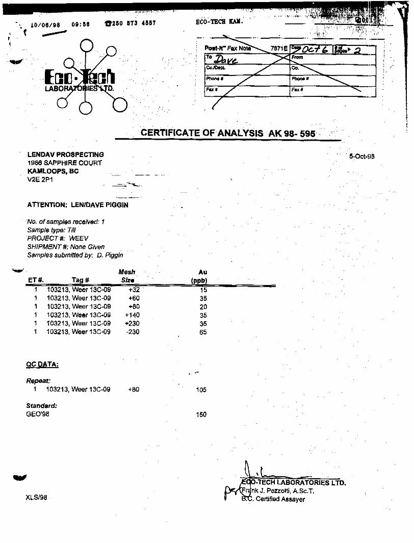
A TILL GRID SURVEY was completed using the location of Tag #lo3282 as the point of orgin. The results of this grid are shown on the attached plot titled “13C Till Sampling Grid”. The full grid could not be competed due to the lack of funds and time therefore, only a portion of the north east quadrant via:<
W done.
A special sieve sample was done at the point of orgin using a larger sample size. The results area as follows: Tag # 104213 (Au : sieve s u e = ppb = pulp wt in grams:
(+32 = 15ppb = 53 gm), (+60 = 35 = 91), (+80 = 20 = 53) (+140 35 =37), (+230 = 35 = 62), (-230 = 65 41).
Another significant stream sediment sample, taken approximately 400 metres to the west of Tag # 103282, returned a signific.mt gold silver anomaly. Tag # 103283 assayed Au 40 ppb, Ag 1.0 ppm, As 65 ppm, Bi 15 ppm, Co 60 ppm, Fe 8.12 YO, Mo 6 ppm. This anomoly is near the contact between the EBGt and EBG.
A third stream sediment sample, taken approximately 200 metres west of Tag #103282, had a silver anomaly. Tag # 103289 assay Au 5 ppb, Ag 2.0 ppm, As 30 ppm, Bi 10, Zn 204 ppm. A number of other streams in the vicinity had anomalous silver values for example Tag # 103292 Ag 1.2 ppm, Tag #lo3295 Ag 1.6, Tag #lo3296 Ag 1.2 ppm. Elevated Zn values were also observed.
These anomalies are within the WEEV claims and will be followed up in 1999.

W 2. AREA“B”:
‘The Geological Survey Branch - Regional Till Survey - Site #540 had a gold value of Au 84 ppb. The site was resample as Tag # 103300 and results were as follows: Au 50 ppb, Ag 0.6 ppm, As 70 ppn . A till sample grid survey was done using Tag#103300 as the point of origin. The grid map can be Found in the Chart titled “Till Sampling Grid for #540”.
‘The underlying bedrock is a green chloritic schist with a feu disseminated pyrite cubes present. The rock was flat lying and apparently not significantly foliated. At times quartz sericite schists were observed. The till is generally shallow sometimes less than 1 metre deep. This site is near the contac:t between the EBGq and EBG and has geological characteristics similar to AREA “A” except that the EBGt is apparently absent.
‘The full grid could not be competed due to the lack of funds and time. The ice direction was due rmth south therefore, a portion of the north east quadrant and north west quadrant were done. A few sampler were taken just south of #540. . The source of the anomaly is hidden by basal till and a thin vf~meer of ablation till. The till sample grid survey needs to be completed in 1999.
The VMS float boulder was sampled with the following results:
Tag # 103278: Au 10 ppb, Ag <0.2 ppm, Cu 1426 ppm, Fe >lo%, Mo 26 ppm, Co 192 ppm. Tag # 104202:: Au 20 ppb, Ag 0.6 ppm, Cu 1441 ppm, Fe >lo%, Mo 20 ppm, Co 148 ppm.
This rock was discovered on the Barr Claims in the early 1980’s. The adjacent logging roads, skid trails and landing were prospected to determine the source of the float but the source was not found. It may be necessary to use remote geophysical techniques to find the source. This boulder may be from the EBL Property but the type of mineralization is not typical of the mineralization observed in the old EBL core boxes.
W
Anomalous or elevated assay values were obtained from the following float boulders:
Suspect iron carbonate type float rock.
Tag # 103290: Bi 10 ppm, Co 112 ppm, Cu 76 ppm, Fe >lo%, Mo 5 ppm, Ni 368 ppm
Tag # 103299: Bi 25 ppm, Co 34 ppm, Cu 4 ppm, Fe >lo%, Mo 11 ppm, Ni 29 ppm


5 h
a 5 w
2
MA

iur
W
U
yr
V.


N C
-
~. ~
.." ~ .......
. . . ..
..... ~ .".
~ .
7
T-
Lo m
Lo
N
blm
cn
m
N
m
N
m
N
m
NN
W
Lo
Lo
Lo
0
0
0
00
0
mm
m
0
NN
N
mm
m
T-
x"
7
7
"?
0
00
v
"T
-
7
Lo
Lo
2 I
n8
0

2-
r- r
0
mi
2 2
I
N

N
c
s i=
n
n
s s s z
N
8
N
r. m
m
c? r,
ID
W
co ri co W
W
0
r
~~
m
W
* N
r.
In
N

W
W
W
N
r
m
r
r
r
m
.- r.
m
N
r
r. W
r.
z W
r
r
0
r
r
9 ~~
I
0,
vi
~
m
a
0
N
x# .- x V
v: C
0
N
r. N
v)
In
W
0
r.
W
N
m
%
0
P
0
m P
m
r
n
m
0~~
W
N
m
a
N
P
x N
W
x x N
2
r
x s
- x
x W
2 x
r
r
r
T-
2 0
0
V
i i -
s
-
m
p!
W
r
0
A .-
0 7
0
m
r
0
A r
m
0-
r
W
I i
I !
~ ~
.
. . .
m m
z m
m
z I
m m
m m
m
m
m
m
m
m
m
m
m

r. r-
In N
0'
r
i= r.1
LD
W
Y In
J7 I, I
,
2 2
V V
In
m

m
N,
ml
W'
N
N
m
N
l
r'
m
LD
IC
0
r. 0
r.
N
C
>
-
r
8 8 d
V
m
N
0
m
z N
r
m
0
d
m
m 0
P
0
d
m
m
IC
IC
LD
,
m
m
N
r
0
dl
'4 0,
r
N
:
m
Y 0
r. m
r
m
P
r
Y'
Y e,
e Y e
x,
Y e!
w 0,
O!
2
r
w
m
0
0
N
N
8 8
r
r
m
m
0.
z N

.~
~
0
N
V
0
N
v 0
N
V
~-
2 m
. ~~ LD
0
m
0
0
0,
r. 0
m
r.

I

I
8 ?
:
m
m

... ~~
! ! l
__..
.. I
m
m zl
z :
m m
m- m
.
"A""
E!
(v' 7
!
r
7!
r 0
G) 0
m n

r- m
Ui
r
$! N
C
5
"
0
~-
0,
m
(D
r. <:I
0
<:> co
c:i 1.
0
m s! 8
s 0
& Lo -
x $ z
5:
5: Lo
0
m Lo
.- 03 CY .- .- 7-
. . ~.
I

>
3
I-
10 N
-3
W
W
m
m
m
0
W
LD
2 2
2 W
m
LD
W
W
8
W
W
W
9
LD
0
W
W
m
r.
N
0
2 m
?
m
m
9
m
0
0
0
0
0
V
h
m
r
'cr
0
V
r
~~
0
V r
0
V
0
r
_~
u? r
N
* 'cr r
m
r
r. 2
.. .~
0
~ ~
v-
W
N
m
m
N
W
N
m
v
W
m
x ~~ W
r
0
x
W
r
0
0
P
r
m
$1 r
-t a,
0
LD
0
+ 0
0
c 0
N
N
0
z f, -
* m a,
x 2
m 0
t, s
z *
* LD
N
N
0
N
c
0
0
0
0
s s
0
c"

N
c
3
s i=
v) c -
n
v)
x 21 V
0
m
N
r
m
W
z W
(D
0
0
'D *
m 7
W m m a

W
BRITISH COLUMBIA PROSPECTORS ASSISTANCE PROGRAM
PROSPECTING REPORT F O W (continued)
- B. TECHNICAL REPORT
One technical report to be completed for each project are& - . Refer to Program RequinmentsJRegulations 15 to 17, page 6. If work was performed on claims a copy of the applicable assessment report may be submitted in lieu of the supporting data (see section 16) required with this TECHNICAL REPORT.
I "J
"
Supporting data must be submitted with this TECHNICAL REPORT Inlormarion on lhb form is conlidenlinl lor one year from Ihr date of rcecipt subject lo the provisions oilhe Fwedont oflnformation Acf.
Prospectors Assisfarce Program - Guidebook 1998 "_ I:i

Harper Creek - #2: Project 98/99 P94
A mid-season review of claims and mineralization in the BottrellChiplBirkiHarper Creek areas revealed a number of the “NB” claims had recently expired. These claims cover MINFILE 082M060. A follow-up road recce on September 24, 1998 revealed numerous VMS outcrops, and old trenches.
A number of rock samples were collected and Tag # I04214 was assayed. The assay results were as follows: Au 955 ppb, Ag 1.0 ppm, As <5 ppm, Co 85 ppm, Cu 1607 ppm, Mo 25 ppm. The MINFILE indicated Au ,370 g/t, Ag 24.0 g/t, 2.1 YO Cu. In October 1998 the Northl, North2, and North3 claims were staked over some of the former NB Claims.
On October 20, 1998 a field trip was made with Graeme Evans, P. Geo., of Teck Corporation. A walk through recce was done and a number of trenches examined, an old drill collar was observed, and the enterence to an old shaft (VMS outcrop)was examined. A number of rock grab samples were {.&en and (haeme had one assayed. The results of the grab sample are still pending.
On November 22, 1998 one of the shafts and two old trenches were found. A number of rock samples were collected and will be assayed subject to discussions with Graeme Evans.
There was a great deal of assessment work done on this occurence therefore, in the coming months all the work from the previous assessments will be reviewed in order to compile the existing work, develop a plan for future works, and prepare an Investors Package. Graeme was pleased with the property and a follow-up field trip is scheduled in the near future.
v


Piggin, Dave F0R:EX *IF'
From: Cathro. Mike EM:EX Sent: To:
Monday, October 19, 1998 1:44 PM
Subject: Piggin, Dave F0R:EX Harper showing - minfile write-up
Dave, here is a MlNFlLE write-up for that Harper showing which you staked on your North 1-2 claims. Hope it helps.
Mike
MlNFlLE NUMBER: 082M 060 NATIONAL MINERAL INVENTORY:
STATUS: Prospect MINING DIVISION: Kamloops NAME(S): HARPER. ULTIMA, LUCKY BOY, WAH WAH, NB
REGIONS: British Columbia NTS MAP: 082M05W UTM ZONE: 11 (NAD 27) LATlTUDE:~51 20 30 N NORTHING: 5691481 ~ ' LONGITUDE: 119 541 30 W EASTING: 300919 ~~ ~ ~~ ~
ELEVATION: 940 Metres LOCATION ACCURACY: Within 500M COMMENTS: West sulphide band, Maps 1 & 2, (Assessment Report 6177).
COMMODITIES: Copper Zinc Lead Silver Gold
MINERALS SIGNIFICANT: Pyrrhotite Pyrite Sphalerite Galena Chalcopyrite ASSOCIATED: Quartz MINERALIZATION .AGE: Unknown
.
- DEPOSIT CHARACTER: Stratabound Stratiform Disseminated Massive CLASSIFICATION: Syngenetic TYPE: GO6 Noranda/Kuroko massive sulphide Cu-Pb-Zn SHAPE: Tabular DIMENSION: 0100 x 0050 x 0008 Metres COMMENTS: West sulphide band.
STRIKEIDIP: 155125W TRENDIPLUNGE:
HOST ROCK DOMINANT HOST ROCK: Metamorphic
STRATIGRAPHIC AGE GROUP FORMATION IGNEOUSlMETAMORPHlClOTHER Devonian Undefined Group Eagle Bay
LITHOLOGY: Sericite Schist Phyllite Gossan
TECTONIC BELT: Omineca PHYSIOGRAPHIC AREA: Shuswap Highland GEOLOGICAL SETTING
TERRANE: Kootenay METAMORPHIC n'PE: Regional RELATIONSHIP: GRADE: Greenschist . . INVENTORY ORE ZONE: SAMPLE REPORT ON: N CATEGORY: Assaylanalysis YEAR: 1983 SAMPLE TYPE: Grab
COMMODITY GRADE Silver 24.0000 Grams per tonne Gold 0.3700 Grams per tonne Copper 2.1000 Per cent
, .
REFERENCE: Assessment Report 12442
Page 1

W The area is underlain by metavolcanics and metasediments of the Devonian age part of the Eagle Bay Formaticn. CAPSULE GEOLOGY
The rocks consist o i phyllites and schists derived from felsic to intermediate volcanic volcaniclastic rocks. The strata forms a homoclinal sequence with a moderate, uniform southwesterly dip. The Cretaceous Baldy Batholith lies to the north.
chalcoovrite. SDhaler- ite and galena. Two main subhide bands. trendinq northwest and diapinq southwest at Mineralization occurs as stratabound bands of massive sulphides consisting of pyrrhotite and pyrite and lesser
to 45 d&grees,'occur within quartz schist. The westernmost subhide band strikes over 100 metres, with UD to 8 metre widths and over 50 metre depths. A. 1
- . . -
metre chip sample from an adit wall gave 0.41 per cent copper, 6.86 grams per tonne silver and 0.14 grams per tonne gold (Assessment Report 12442). The easternmost sulphide band has a length of 210 metres, a vertical depth of at least 20 metres and variable widths. A grab sample at the northern end of the zone returned 2.1 per cent copper, 24 grams per tonne silver and 0.37 grams per tonne gold (Assessment Report 12442). This band lies 175 metres northeast of the western band. In addition to the two main sulphide bands, a prominent gossan zone with sulphide outcrops and anomalous geochemical results lies 1000 metres southwest of the western sulphide band. Also, 300 metres northwest of ths western band, a drill hole cut a 1 to 2 metre section assaying .93 per cent zinc and . I 8 per cent copper (Assessment Report 12442). Drilling (Assessment Report 6177) in an area 400 metres northwest of the west sulphide band, intersected coprt?r values from 0.15 per cent over 7.9 metres to 0.84 per cent over 4.9 metres. BIBLIOGRAPHY
EMPR ASS RPT 2627.3716.6177. 11095. 12442. 12567. 13434. 14388. 15802 GSC OF 637
Dickie, G.J., Preto, V.A. and Schiarizza, P. (in preparation 1986): Mineral Deposits of the Adams Plateau-
I . . EMPR FIELDWORK 1978, pp. 31-37; 1984, pp. 67-76
Clearwater Area
Region in GSA Cordilleran Section Meeting May 1985, pp. 16-1 to 16-11 Preto, V.A. and Schiarizza. P. (1985): Geology and Mineral Deposits of the Adams Plateau-Clearwater
EMPRAR 1927-189; 1962-60-61; 1963-59; 1965-159; 1966-145
EMPR EXPL 1976-E61-E62; 1982-116; 1983-160; 1986-C115 EMPR GEM 1970-313-314; 1972-88
GSC SUM fIPT 1921A, pp. 105, 106 EMPR MAP 56 GSC MAP 48-1963
DATE CODED: 850724 CODED BY: GSB DATE REVISED: 870730
FIELD CHECK: N REVISED BY: LDJ FIELD CHECK: N
Mlke
Mike Cathro Regional Geologist Mines Branch. Kamloops
tel. 250 8284566 fax :250 828-4726 Email: Mike.Cathro@gf:ms2.gov.bc.ca
Page 2

BRITISH COLUMBIA PROSPECTORS ASSISTANCE PROGRAM
PROSPECTING REPORT F O W (continued)
. B. TECHNICAL REPORT
One technical report to be completed for each project ana Refer to Proxram RequiremenWRegulations 15 t i 17, page 6. I f work was performed on claims a copy of the applicable assessment report may be submitted in lieu of the
- .
supporting data (see section 16) required with this TECHNICAL REPORT.
W WORK PERFORMED I . Conventional Prospecting (area) 2. Geological Mapping (hectaredscale) MIL 3. Geochemical (type and no. of samples) R o e K - 2 nuHeJoes .Fa/r.n/o< Nr) fasr, ,2?%*. 4. Geophysical (type and line !an) d/L 5 . Physical Work (type and amount) @LA/M %??K//v/& - 3-4 d&&u 6 . Drilling (no. holes, size, depth in m, total m) NIL 7. Other (specify)-
""
". ".
SIGNIFICANT RESULTS" i f ;3+~ em ~~f Commodities - M
Claim Name s/?AP2 2/?/'3, .s/#'/'4'- Location (show on map) Lat gL' r y ' 92 '' d Long // foYV~.'7 7''VEle;ation /JO'U .
"
W
Supporting data must be submitted with this TECHNICAL REPORT Inrormntion on this form is confidential for one year rrom the dale or receipt avbjrrt to the provisions of the Freedom of Informtion Acf.
Prospectors Assistance Program ~ Guidebook 1998 -" / .i

W Adams Lake - #3: Project 98/99 P94
The Adams Lake #3 is located 1 km west (adjacent) of the CamiGloria Property MINFILE 082M266. This prospect is within a large, rusty, auriferous quartz vein which contains pyrite, galena and chalcopyrite. The vein is up to I O metres wide and 300 metres in length and is hosted by Cretaceous monzonite of the Baldy Batholith near its contact with gneissic metasediments of the Eagle Bay Assemblage. A KEY MAP for the C d G l o r i a and SPAP claims are enclosed.
It is hoped thai. the auriferous quartz extends into the area of the SPAP claims. Prospecting focused on walk through surveys to do determine the presence of other Au Ag Bi bearing quartz veins or structures. The area was jointly prospected by David Piggin, Len Piggin, and Camille Berube.
Walk through surveys revealed a Red Soil Zone which has developed from an oxidized granitic bedrock. Till and boulder sampling revealed the following:
1. Stump Hill: a contact between the Baldy Batholith (Kg) containing zenoliths, and redish oxidized granitic bedrock. . The contact was followed for 30 metres.The redish bedrock was causing the red soil zone
well described at this time). This small hill is located 300 m south of Stump Hill.
Geological contacts between the Baldy Batholith (with zenoliths) and the older volcanic suggest the potential for underlying mineralization based on comments made by a local geologist from a major mining company. This geologic contact is on trend with the strike of the auriferous quartz vein at CamiGloria.
So far assay results in the vicinity of the red soil zone have been negative.
A self potential survey was conducted on Stump Hill to see if the geologic contact could be reliably followed. The results of the survey are enclosed.
V 2. Landing Hill: A contact with the redish oxidized granitic bedrock and older volcanics (not
W


+


- v) X
I I? 0
(? O
O
9
0


w
BRITISH COLUMBIA PROSPECTORS ASSISTANCE PROGRAM
PROSPECTING REPORT F O W (continued)
- B. TECHNICAL REPORT
One technical report to be completed for each project ma. - Refer to Program RequirementJRcgulations I5 t i 17, page 6. If work Was performed on claims a copy ofthe applicable aseSSment report may be submitted in lieu ofthe supporting data (see section 16) required with this TECHNICAL REPORT.
Name Reference Number
LOCATIONKOMMODITIES I
Project Area (as listed iiiP%l Ar-fld &u#FfDS - MINFILE No. if applicable Location of Project Area- Description of LOC
-" "" . Lat T/ 3 'd Long /2@0 5. /kt' ." / L" ." e ."
WORK PERFORMED 1. Conventional Prospecting (area) k & L I /&rF4Z f 6uhw&iIf!6H x I j$g fF/ / r L:2.-, 2. Geological Mapping (hectaredscale) 3. Geochemical (type and no. of samples) 4. Geophysical (type and line km) ' N/L 5 . Physical Work (type and amount) d/L 6. Drilling (no. holes, size, depth in m, total m) M/f/ 7. Other (specify)_
;7 5Jd.@A M r .
."
/L ""
A// L , fh GMP'Lr R o c k ) r /o T &T&%I ~.___I
."
."
""
."
Location (show on map) Lat Long Hevation ""
Best assayisample type d / A - /I/n S&d///F4d7 ,&fffCjS; ".
__ ~~~ ~~
Supporting data must be submitted with this TECHNICAL REPORT Information on lhis form is confidrntisl for one ycsr from the dalc ofrcrcipt subject to lhc provirions of thc Freedom of Informion AcI.
Prospectors Assisfance Program - Guidebook 1998 iT


. . , . . , . . .
CERTIFICATE OF'ANALYSIS AK 98- 595. .. .,...' ' ' . ' .
. . , .. .
LENDAV PROSPECTING 1986 SAPPHIRE COURT
' ' ' 5-oct-OB
KAMLOOPS, BC - VZE 2P1
" - .. . 41. ~-
ATTENTION: LENlDAVE PlGGlN
'No. of samples received: 1
PROJECT #: W E V Sample type: Till
SHIPMENT#: None Given Samples submitted by: D. Piggin
W Mesh Au
1 103213, Weer 13C-09 1 103213, Weer 13C-09 1 103213, Weer 13C-09 1 103213, Weer 13C-09 1 103213, Weer 13C-09
QCTA:
Repeat: 1 103213, Weer 13C-09
Standard: GEO98
W
XLsI98
+60 +80 +140 +230 -230
+80
35 20 35 35 65
. " 105
150
. .. . . . .
. .
. .

” ”_ . . . . . . .
0’ n GEOCHEMISTRY
ASSAYING
ENVIRONMENTAL TEStlNQ ANALYTICAL CHI“
CERTIFICATE OF ANALYSIS AK 98- 595-MESH
LENDAV PROSPECTING 1988 SAPPHIRE COURT KAMLOOPS, BC V2E 2Pi
~- ” - GI. .-
ATIENTDN: LEN/DAVE PIGGIN---
No. of samples received: f Sample type: Til/ PROJECT#: WEEV SHIPMENT #: None Given Samples submitted by: W. plBBin
‘hd Mesh Pulp Wdght SI20 +10 53 +32 91 +60 53 +80 37
+I40 62 +230 38
a
-230 41
r
W

J
S 0
Y

W
0 ?
0
0
h
::


W
I t'
0
u)
N'
D
9 3

0
N
N 0
0
"7 N
m
0
N
N - -
0
N

0
N
m
Y
4
2 0
LL c
U
a 5 2
..

N
N
2 m

'CJ
Y
4
.

'C
.
.

w
Y a
W
N
s! W
*

".
H a

W
.
? w
W
..
w
Y,
Y,
'D 'D
d: I
N
N
0
m M
ti ti 3
0
0
0
* (D
*
" v)
2 0
Io
Y,
m
" x 7 VI
v)
N
* w Io ""
N

;s
.
4
x a
2
R

Yd

h

*.*
.
..

.
L
a
0

.-

<-,

w


ar
m 2 m

I-
\
4%


.

"W
W
"7
m
0
N
T
0
v)

.
u
a F