Embed Size (px)
Citation preview
Clark University
Mining and Tourist Towns in the Canadian RockiesAuthor(s): Stephen B. JonesSource: Economic Geography, Vol. 9, No. 4 (Oct., 1933), pp. 368-378Published by: Clark UniversityStable URL: http://www.jstor.org/stable/140491 .
Accessed: 08/05/2014 20:25
Your use of the JSTOR archive indicates your acceptance of the Terms & Conditions of Use, available at .http://www.jstor.org/page/info/about/policies/terms.jsp
.JSTOR is a not-for-profit service that helps scholars, researchers, and students discover, use, and build upon a wide range ofcontent in a trusted digital archive. We use information technology and tools to increase productivity and facilitate new formsof scholarship. For more information about JSTOR, please contact [email protected].
.
Clark University is collaborating with JSTOR to digitize, preserve and extend access to Economic Geography.
http://www.jstor.org
This content downloaded from 169.229.32.137 on Thu, 8 May 2014 20:25:03 PMAll use subject to JSTOR Terms and Conditions

MINING AND TOURIST TOWNS IN THE CANADIAN ROCKIES
Stephen B. Jones
T nHE Canadian Pacific Railway follows Bow River into the Rocky Mountains, the eastern-
most member of the North American Cordillera. Along its route stand two towns, Canmore and Banff, sur- prisingly large for such a remote, mountainous region, and between which there is no more interesting contrast in the geography of all Al berta. The two towns lie but thir- teen miles apart (Figure 1), or twenty minutes by train or motor. Their climates are almost identical and the main features of their landscapes are alike. Both towns are built, for the most part, on the flat floor of the Bow Valley (Figures 5 and 8), and are surrounded by mountains of gray limestone. The one significant dif- ference in the natural landscapes is that coal occurs at Canmore while at Banif there are hot springs.
From a distance, the two towns look not unlike. Both have checker- board down-town sections, the out- lying residences trailing off in shoe- strings (Figures 2 and 7). Small houses, half-hidden by evergreen trees, are the rule. Both towns lie near the river, at a little distance from the railway. In both cases a bridge spans the river and leads to buildings on the mountain slopes beyond.
Even from a distance, certain dif- ferences can be noted. There are more large buildings in down-town Banff and a number of them are of brick (Figures 3 and 8). The Banff
railway station is a long, substantial, stone and plaster structure, in con- trast to the small, red, standardized frame station at Canmore. To the south, about a mile from Banff, towers a castle of dark gray stone- the Banff Springs Hotel. In a some- what analogous location in respect to
N~~~~~
SAWBA4
FIGURE 1. Bow River and its tributaries in the Canadian Rocky Mountains.
Canmore one se-es the coal mines. Closer acquaintance with the two towns brings to light more contrasts. These contrasts in cultural land- scapes are typical of the differences between mining and tourist towns in the Canadian Rockies.
This content downloaded from 169.229.32.137 on Thu, 8 May 2014 20:25:03 PMAll use subject to JSTOR Terms and Conditions

MINING AND TOURIST TOWNS IN THE CANADIAN ROCKIES 369
Mt~~~~t ~
'K
- \> \'~>\\ /CANMORE, ALBERTA
............. \
FIGURE 2.-The predominance of the residen- tial over the commercial property in Canmore is one of its peculiar characteristics.
THE NATURAL LANDSCAPES
"Northward soared the stainless ramps,- Ranged in white ranks against the blue-"
J. Outram, In the Heart of the Canadian Rockies.
These lines epitomize the land- forms of the Canadian Rocky Moun- tains. The Canadian Rockies are composed almost entirely of sedi- mentary rock whose stratification is so evident that visitors untrained in geology usually observe it (Figure 8). It is also obvious that these strata are rarely horizontal. In the vicinities of Banff and Canmore, westerly dips of from thirty to fifty degrees are common and the typical mountain form is a westward-sloping ramp.
These ramps are ranged in ranks. The individual mountains are, as a rule, not peaks but ridges (Figure 3). The ridges trend northwest-south- east, parallel to the regional strike (Figure 1). The individual moun- tain ridges are often but the erosion- severed parts of long and narrow ranges. Familiar to every visitor to Banff are Cascade Mountain (Figure 8), Tunnel Mountain, Mount Rundle, The Three Sisters (Figure 6), and Wind Mountain, all of which form
a narrow range that is a geological unit, though intersected by gaps and passes formed by erosion (Figure 1).
The Canadian Rocky Mountains consist of many of these narrow ranges, in parallel grouping. Into their rocky ranks the Bow Valley forms one of the most perfect natural highways imaginable. As is com- mon in regions where strata of differ- ent resistances to erosion are strongly folded and faulted, the stream pat- tern is trellised. The Bow some- times flows in broad valleys parallel to the regional strike, and again, after making a rectilinear bend, as at Saw- back and The Gap (Figure 1), cuts transversely across the ranges. Yet even where the river is cutting through the ranges the valley floor is broad and level. Up this broad val- ley through the ranges follow the railway and a highway. On its flat floor, in checker-boards reminiscent of prairie towns, stand the main parts of Banff and Canmore.
The climates of Banff and Can- more are essentially continental. For Banff the January mean is 130 F. and the July mean is 580, while the total precipitation is 19.4 inches with a snowfall of 77.1 inches. The pre- cipitation maximum is in June, but the Pacific Coast influence is shown in a secondary maximum in winter. The winters are long, cold, and fairly dry. The summers are short and cool, too cool for any real farming. Banff and Canmore lie at elevations of 4,500 and 4,300 feet, respectively, while the surrounding mountains tower above to elevations of more than 9,000 feet. Canmore is less closely guarded by mountains than is Banff. Consequently, spring comes earlier in Canmore, a month earlier according to residents. Although the total precipitation is light, it is suffi-
This content downloaded from 169.229.32.137 on Thu, 8 May 2014 20:25:03 PMAll use subject to JSTOR Terms and Conditions

370 EcONOMIC GEOGRAPHY
cient, in this cool climate, to clothe the mountains with a dense forest of small evergreen trees. Timber-line is reached at an elevation of about 7,000 feet. In the valleys and on the lower slopes, meadows and poplar groves interrupt the evergreen forest (Figure 5). Dairy cattle are pas- tured in these meadows.
FIUE3-hiain sre o amoea no uin h tuit esn.Got MWsountainon
of the ramp-like ridges of the region, rises in the distance. The strata dip w twrthcae.
X~~~~~~~~~~~~~~~~~~~~~~~~~~~~~~~~~~~~~~~~~~~~~~~~. ". ......l
~~~~~~~~~~~~~~~~~~~~~.. ... .......II _I
FIGURE3.Th main stee of Ia r atno uigtetuitsao.Got onan n
oFIGR the rap-ie maidgestre of thCaginoriesa inondrg the touistane h straason.Grottowr Muthcamera.n
CULTURAL LANDSCAPES: CANMORE
Between Tunnel MIountain and The Gap Bow River flows for fifteen miles parallel to the regional strike (Figure 1). This portion of the val- ley is wide and open (Figure 5) and acquires a special significance in re- gard to human occupance in that it is underlain by a coal-bearing forma- tion, the Kootenay formation of Lower Cretaceous age.
From a distance, the white houses of Canmore, set in the woods of this spacious valley, have a beauty that one rarely associates with a mining industry. The mining parapherna- lia are lost in this gigantic valley. Round about the town are meadows in which the cattle graze. The Bow is a broad and peaceful stream-the
banks wooded, the water clear except at flood. From a distance, too, it can be seen that about half of Canmore is built on the flat valley floor on the east bank of the river (Figures 2 and 5). About half of the remainder lies on an island in the Bow. The rest of the town clings to the hillside on the west bank of the river.
The railway and the highway are here near the eastern edge of the val- ley, across which a spur track and a branch road extend to reach Canmore and the mines. The railway station, garages, and gasoline stations are thus removed from the main part of Canmore (Figure 2). The remote- ness of its transportational center makes Canmore the quietest town in the Canadian Rockies (Figure 3). Tourist activity is impressively ab- sent from the main part of town. The hotel does not even bear a sign. It is largely supported by its beer- parlor. There is no night clerk even during the tourist season. Can- more's stores cater to miners' wants. One can buy Kodak film or postal cards, but the writer looked in vain for pennant, windshield sticker,
This content downloaded from 169.229.32.137 on Thu, 8 May 2014 20:25:03 PMAll use subject to JSTOR Terms and Conditions

MINING AND TOURIST TOWNS IN THE CANADIAN ROCKIES 371
paper-weight, or pearl-handled pen- knife bearing the name of Canmore.
Canmore loses a little of its attrac- tiveness upon closer acquaintance. The streets are unpaved (Figure 3). The sidewalks, if any, are wooden. The houses are small and sometimes in need of paint. Should the day be stormy, there is little in store, hotel, or restaurant to delight the traveller. Nevertheless, Canmore remains con- siderably more attractive than the " typical " mining town (Figure 4). This attractiveness appears to result from the spaciousness of the site, which has permitted a wide spacing of houses and the preservation of groves and single trees, from a low labor turnover and harmonious rela- tions between owners and employees, and from the steady, if small, incomes accruing to the miners from the year- round operation of the mines, the railway being the chief customer.
The section east of the river is laid out in checker-board fashion (Figure 2). Locally, it is called " the govern- ment town," for when it was platted Canmore was within the boundaries of Banff National Park. Being an "open" town, the government sec- tion has become the commercial cen- ter of Canmore. Here, also, are about half the homes. The houses are small, regularly arranged, and usually well-kept (Figure 4). The lawns are fenced and the large back- yards are often used for vegetable gardens. Flowers and trees are nu- merous.
West of the checker-board section the land belongs to the mining com- pany and the remainder of Canmore is known as " the company town " or "the mine camp." The island por- tion of the mine camp is level but the west bank, formed in part of glacial drift, rises with a moderate slope to
-~~~~~~~~~~~~~~~~~~~~~~~~~~~~~~~~~~~~~~~~~- - ---- --
FIGURE 4.-Miners' cabins in the "government town" of Canmore. Fences and trees are char- acteristic, and well-kept walls and roofs are not unusual.
the base of the mountains (Figure 6). Except for a few fine residences for officials on the island, a general mo- notony of architecture and color throughout the mine camp indicates company ownership. Proximity to the mines is sufficient to explain the growth of settlements on the low is- land and the hilly west bank, though so much level land on the east bank remains unoccupied.
The area devoted to residential occupance in Canmore, as scaled from Figure 2, is almost exactly ten times the commercial area. This figure will become significant when it is compared with the corresponding ratio for Banff.
In the struggle for existence among coal mines, those at Canmore have survived. Principally, the survival of the Canmore mines traces back to their location on the Canadian Pacific Railway, which railway means trans- portation to markets. What is far more important, it is itself a market, consuming, in 1930, four-fifths of the output.
Yet survival is not synonymous with prosperity-most assuredly not in the coal industry. Nor are natu- ral resources necessarily wealth. Al- berta contains one-seventh of the world's coal and nine-tenths of Can-
This content downloaded from 169.229.32.137 on Thu, 8 May 2014 20:25:03 PMAll use subject to JSTOR Terms and Conditions
372 EcONOMIc GEOGRAPHY
ada's, but these reserves have bare- ly been scratched. Development is confined to the few places in which coal seams are reached by rail trans- portation. Nevertheless, M. J. Pat- ton, writing of the developed coal mines of Alberta, says; "These are capable of producing from three to four times as much coal as they can sell."
The only undisputed market for Alberta coal is Alberta. One-seventh of the world's coal thus has for its assured market one three-thousandth of the world's population. Sas- katchewan, Manitoba, and British Columbia purchase some Alberta coal but the sales fall off rapidly with dis- tance.
No outside coal fields dispute the Alberta market but it cannot be said that there is no competition. Natu- ral gas has been found in abundance in Alberta. The four largest cities and many of the smaller towns, total- ing one-third of the population of the province, are supplied with this con- venient fuel.
For what is left of the domestic
market, the Canmore mines must compete with those in a dozen other coal fields in Alberta. The Canmore seams dip steeply and mining is ex- pensive. In the plains of Alberta are great quantities of lignite (euphe- mistically called " domestic coal "). The lignite seams are horizontal and are easily mined. "Domestic coal" is clean and is less destructive to grates than are higher rank coals. It is even sold in Banff, on the very doorstep of the Canmore field, for home heating. The figures are con- clusive: In 1930 the Drumheller lig- nite mines sold 270,000 tons on the Alberta market; the Canmore mines sold 26,000 tons (exclusive of sales to railways).
In the last analysis, therefore, Can- more is the dependent child of the railway. This condition has had some advantages. The peak of the railway demand comes in summer, and sales on the domestic market tend to minimize the winter slump. But even the railway market is not assured. Competition for tourist travel forced the Canadian Pacific to
i~~~~~~~~~~~~~~~~~~~~~~~~~~~~~~~~~~~~~~~~~~~~~~~~~~~~~~~..... .. s-h
M.~~~~~~~~~~4-
M i Ad -A1 ~~~~~~~~~ ~~~~~~~~~~~~~~~
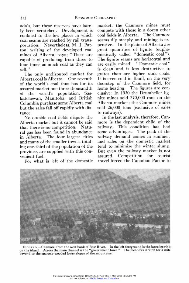
FIGURE 5.-Canmore, from the west bank of Bow River. In the left foreground is the large ice rink on the island. Across the main channel is the "government town." The meadows stretch for a mile beyond to the sparsely-wooded lower slopes of the mountains.
This content downloaded from 169.229.32.137 on Thu, 8 May 2014 20:25:03 PMAll use subject to JSTOR Terms and Conditions

MINING AND TOURIST TOWNS IN THE CANADIAN ROCKIES 373
;N-~~~~~~~~~~~~~~~~~~~~~~~~~~~~~~~~~~~~~~~~~~~~~~~~~~~~~5
FIGURE 6. The hilly portion of Canmore, on the west bank of the Bow. The sharp peaks are two~~~~~~~~~~~~~~~~~~~~~~~...... .. of The Three Sisters (Figure 1).~~~~~~~~~~~~~~~~~~~~~~~~~~~~~~~~~~~~~~~~~~~~~~~~~~~~~~~~~~~~~~~~~~~~.. ... .
convert the passenger locomotives on its mountain divisions to the use of oil fuel. Improvements in the design of locomotives have reduced their coal consumption. Diesel-electric loco- motives are in prospect. The search for oil in Western Canada, so far meagerly rewarded, continues. In the Rocky Mountain Trench lie enor- mous potentialities in water power. But why borrow trouble? Canmore has worries enough.
CULTURAL LANDSCAPES: BANFF
As one enters Banff the contrasts between it and Canmore are at once evident. The streets of Banff are wide and many of them have been paved (Figure 8). They bear such "tourist-y" names as Bear Street, Beaver Street, and Spray Avenue. There are many small summer cot- tages but the houses, in general, are larger than those of Canmore (Figure 9). Some are pretentious. Some of the contrasts, such as the pavements and the fine residences, may be at-
tributal)le in part to the greater size of Banff, (2,519 as compared to Can- more with 1,134), but most of the differences in cultural landscape be- tween Banif and Canmore are expres- sions of their respective industries.
In the summer of 1932, thirty-five per cent of the residences in Banff ad- vertised accommodations for tourists, rooms, back-yard cabins, or both. tn only one per cent of Canmore's residences are accommodations of- fered. The permanent population of Banff is 2.2 times that of Canmore, but Banff has 2.8 times as many resi- (lences. Even though Banff families may average slightly smaller than those of Canmore, the greater num- ber of houses in proportion to per- manent population indicates that many are occupied only seasonally.
Commercial Banff likewise presents contrasts to commercial Canmore. \V'ith 2.2 times the permanent popu- lation, Banif has four times the com- mercial area. In Canmore, the ratio of residential to commercial area is
This content downloaded from 169.229.32.137 on Thu, 8 May 2014 20:25:03 PMAll use subject to JSTOR Terms and Conditions

374 ECONOMic GEOGRAPHY
ten to one. In Banif, the corre- sponding ratio is 6.5 to one. The sig- nificance of these figures is, of course, that Banif's business is geared to the tourist travel and not to the number of permanent residents.
The nature and number of Banff's stores testify to the patronage of tourists in a holiday mood. The following table shows not only that the business enterprises of Banff are far more numerous than those of Canmore, even in proportion to popu- lation, but also that Banff's business is much more specialized and varied: BUSINESS ENTERPRISES IN BANFF AND CANMORE, AUGUST,
1932 Banif Canmore
Bakeries .............................. 3 Banks ................................1 Barber and Beauty Shops ............... 2 1 Beer Parlors ............................ 3 1 Dance Halls ...........................
2 Department Stores ......... ............ 1 Dairy Sales Rooms ..................... 1 Drug Stores ........................... 3 1 Frnit Stores.2 Fri trs. . . . . . . . . . . . . . . . . . . . . . . . . ......2 Fuel and Lumber Yards ................ 2 Furriers ............................... 1 Garages, Commercial......... . .............7 2 Garages, Company ............3..... 3 Gasoline Stations ...................... 3 1 General Stores . .3 Grocery Stores ....................... 3 1 Hardware Stores .......... ............. 2 Hotels, Commercial .................... 9 1 Hotels, Y. M. C. A . . 1 Hotels, Y. W. C. A .....................1 Jewelers .............................. 2 Laundries ........ . ................... 4 2 Liquor Stores, Retail ................... 1 Liquor Stores, Wholesale ................ 1 Meat Markets ......................... 2 Motion Picture Theatres ................ 1 Newspaper Publishers .................. 1 Pool Halls ............................ 2 Professional Offices ...............-.5 1 Restaurants ........................... 8 2 Shoe Repair Shops ..................... 2 1 Shoe Shine Parlors ......... ............ 2 Souvenir Stores ........................ 8
The last entry is perhaps as signifi- cant as any.
In Canmore, the "general store" is the prevailing mode of merchandising. In Banif there are stores specializing in bakery goods, dairy products, fruits, and meat, in trinkets, photo- graphs, and furs. Unlike Canmore, Banff's stores, hotels, and restaurants can entertain the storm-bound trav- eller for many hours.
1t'
BANFF, ALBERTA _ qCRCof (AL
wa..oPos r \\ \N
,V SCS/r7SrIA4 HO$VOS. owr-4 \\. * Sor A E540rNC E SCH. AOo 5\A< CNII>RC ADS. GWVtr9Nol40t r> \\ \
F IGAUE 7STWAhe psisn d n of B f d
fro is{ foninXt0Sg>f whe avthe mansret ai
R RwOs stakd otbthfitpr t (Fue 8, T c
oldstp ^art ofcth town.
RWV. RAwA~ o0.ao0rN4, sArrOIv \
T soot plan of Ban
FIGURE 7.oThe persistent design of Banff dates from its founding when the main street, Banff Avenue, was staked out by the first park superin- tendent to give the best view of Cascade Moun- tain (Figure 8). The commercial section is the oldest part of the town.
The street plan of Banff, unlike that of Canmore, shows clear evi- dence of a persistent design (Figures 2 and 7). The land is government- owned and the town is controlled by the national park authorities. Prox- imity to the hot springs determined the site. The springs emerge from the slopes of Sulphur Mountain, southwest of Bow River (Figure 1), but the nearest Ilevel and dry land lay across the river, where down-town Banif now stands. What is now the
This content downloaded from 169.229.32.137 on Thu, 8 May 2014 20:25:03 PMAll use subject to JSTOR Terms and Conditions

MINING AND TOURIST TOWNS IN THE CANADIAN ROCKIES 375
commercial section is the oldest part of town.
The persistent design dates from the town's founding, in 1885, when the main street, Banff Avenue, was staked out by the first park superin- tendent to give the best view of Cas- cade Mountain (Figure 8). As the town grew, the residential districts spread towards the northeast, chiefly. The land was dry and level in this di- rection and, furthermore, the high- way from the east approached this sector. Figure 7 shows a distinct concentration of accommodations for tourists in this northeastern district. Statistics bear out this impression. Seventy per cent of the residences at which tourists can be accommodated
: ...: .. .: ... ::..:M .
-!w~~~~~~~~~~~~~~~~~~~~~~~~~~~~~~~~~~~~~~2
FIGURE 8.-Banff Avenue, looking north toward Cascade Mountain. The pavement, the concrete sidewalks, and the larger buildings contrast with Canmore's main street (Figure 3). The westward dip of the strata in Cascade Mountain is evident. Cascade Mountain appears to be a peak, but, in reality, is a long ridge stretching to the northwest (Figure 1).
lie northeast of Wolf Street although only fifty-four per cent of the total number of residences are in this sec- tion. That four-fifths of the visitors of Banff National Park arrive by motor and that more than half of them come from the east explain
the concentration of accommodations near the highway entrance.
Banff owes its founding to the presence of hot springs. The name of the Banff Springs Hotel perpetu- ates this memory. Banff remains a health resort, but in a small way. Perhaps three per cent of the visitors come to take baths for health pur- poses. A far more important use of the hot springs, financially speak- ing, is for pleasure bathing. Today, Banff is predominantly a pleasure resort, where people come for riding, tramping, fishing, or plain loafing.
POPULATIONS COMPARED
Figure 10 shows graphically the racial composition of the popula-
tion of certain Alberta cities, towns, and districts. Examination of these charts reveals persistent differences in the composition of the population of mining and commercial centers, the tourist town of Banff being in- cluded in the latter.
This content downloaded from 169.229.32.137 on Thu, 8 May 2014 20:25:03 PMAll use subject to JSTOR Terms and Conditions

376 ECONOMIC GEOGRAPHY
FIGURE 9. Typical home of a permanent resident of Banff. Glass-enclosed porches are common in this land of cold but sunny winters.
The general similarity of the racial composition of the population of Banff and Calgarywill beobserved. Calgary is the principal commercial, manufac- turing, and railway center of southern Alberta, Table II. Banff, as has been noted, is a strongly commercial town.
TABLE II Population
(Round Numbers)
Banff .................................. 2,500 Calgary ..... ........................ 83,000 High River ...... . ...................... 1,500 Claresholm .............................. 1,200 Coleman ................................ 1,700 Blairmore ............................... 1,600 Drumheller ............................. 3,000 Unorganized (includes Canmore, 1,100). 2,250
The most significant difference is the high proportion of Chinese and Japa- nese in the population of Banff. Con- siderable Oriental help is employed in hotels and restaurants, as well as in laundries, and all three types of busi- ness are more numerous, in proportion to population, in Banff than in Calgary.
High River and Claresholm are commercial centers in agricultural districts in the plains south of Cal- gary. They represent typical south- ern Alberta country towns. Racially they resemble Calgary and Banff in the high percentage of British peo- ples. The variations in the other elements probably reflect the com- position of the population of the sur- rounding agricultural districts.
Representing coal-mining towns in
the Canadian Rockies, data for Cole- man, Blairmore, and the unorganized district that includes Canmore are
charted. In all these settlements, the proportion of British peoples is low-about fifty per cent of the to- tal population. Scotland and Wales have contributed many coal-miners to North America. It will be ob- served that there are more Scotch, in proportion to English, although not in proportion to total population, in the mining towns of Coleman and Blairmore than in the commercial towns. The proportion of Welsh in the total population is greater in these towns. Italians are the most numerous group in Coleman, Blair- more, and Canmore. Poles and "Other Europeans" are numerous. The most conspicuous anomaly is the high proportion of Chinese and Japa- nese in the unorganized district. This district includes a number of tourist resorts and it is probable that many of these Orientals are em- ployees in hotels and restaurants.
The data for Drumheller are in- cluded as indicative of a town that is both a coal-mining and a commercial center. Drumheller is in the lignite field, northeast of Calgary, and is the trading center for the surround- ing agricultural region. The charts clearly indicate that the racial com- position of its population is inter- mediate in character between those of the commercial and mining towns.
SPORTS AND PASTIMES IN BANFF AND CANMORE
Arnold Lunn reminds us: " The historian . . . is apt to forget that
sport in some form or other is the main object of most lives, that most men work in order to play, and that games which bulk so largely in the life of the individual cannot be neglected in studying the life of the nation."
This content downloaded from 169.229.32.137 on Thu, 8 May 2014 20:25:03 PMAll use subject to JSTOR Terms and Conditions

MINING AND TOURIST TOWNS IN THE CANADIAN ROCKIES 377
......... 'WX .. .... ....Gr.~AIVHIR7%........... - AMA
// N .-' 8% ..~~~OM im s, CAVO N II 1.. ........ -AN0 1f t A0 C 1
_/ -\ aft$ - / 15% ~ ~ ~ ~ ~ ~ ~ ~ ~ 9
0 i l ? 4 100Q434B~~~~lE W 3 0 3\2 3 2 0/$| X~~~~-9.' 1', \
9. 9t X 8-. * '' - 7 FI E 10 R l cd diti FI UR 0. R cilco p siio f h p plainsofcrti Abrt ites ow s a dditics
Canmore's favorite sport is ice hockey. Canmore hockey teams are often among the leading competitors in Western Canadian leagues. The well-built skating arena is one of the most conspicuous buildings in town (Figure 5). Ice hockey is likewise popular in Banff, though not to the same degree as in Canmore. Skating and curling are popular in both towns.
The snow sports, on the other hand, are more popular in Banff than in Canmore. The young people of Banif have been especially active in cross-country skiing. It is true that Canmore lies at a slightly lower alti- tude than Banff and nearer the east or dry side of the Canadian Rockies. But the snowfall at Banff is likewise light, yet the young people seek fa- vorable places at higher altitudes.
The summer sport of mountain climbing is likewise more popular in Banff than in Canmore. The Can- morites have plenty of leisure, for the mines have been worked but two or three days a week in recent years, and there are plenty of mountains. Yet the writer knows of but one alpinist in Canmore and this man does most
of his climbing with friends from Cal- gary. Fishing, gardening, and the upkeep of houses appear to absorb much of the summer leisure of the people of Canmore. The summer camp of the Canmore Y. M. C. A. is not in the mountains but in the foot- hills.
Lack of contact with tourists is probably the major factor accounting for the paucity of interest, in Can- more, in the exploratory sports of mountaineering and cross-country skiing, which are replaced in popular appeal by social and competitive games and by the more productive pastimes of fishing and gardening. Factors of race, education, or eco- nomic condition may enter.
CONCLUSIONS
There are many contrasts between the neighboring Canadian Rocky Mountain towns of Banff and Can- more. Two industries are being car- ried on, almost literally side by side, in natural environments in many ways identical. One, the tourist in- dustry, is widely-known. It supports spacious hotels, fine stores, and an elaborate assortment of recreational
This content downloaded from 169.229.32.137 on Thu, 8 May 2014 20:25:03 PMAll use subject to JSTOR Terms and Conditions

378 ECONoMIc GEOGRAPHY
services. Like a mountain flower it blooms astonishingly during the short summer, then lies nearly dormant for the eight or nine months of winter. Banif, supplying luxuries, is generally prosperous.
The other industry, coal-mining, plods along in obscurity, little af- fected by season because of its rail- way market. Supplying a basic ne- cessity of modern civilization, it has not known prosperity for many years. From a distance Canmore may re- semble Banff, but the resemblance breaks down on closer acquaintance. The two towns are different in form
and function. They differ racially, socially, and even psychologically.
Yet these two towns have some- thing in common. Both are products of modern industrial civilization; both are dependent children of mechanical transportation. They exemplify the geographical division of labor that has been a sweeping consequence of the Industrial Revolution. In natural environments generally similar, there are two main economic resources, coal and scenery. Canmore exploits one and Banff the other, and from this fundamental cleavage spring the contrasts that the two towns present.
This content downloaded from 169.229.32.137 on Thu, 8 May 2014 20:25:03 PMAll use subject to JSTOR Terms and Conditions