Embed Size (px)
Citation preview

Mines and Mineral Statistics, 1899 – Page 1 of 112
STATE OF MICHIGAN,
MINES AND
MINERAL STATISTICS
BY
GEORGE A. NEWETT
COMMISSIONER OF MINERAL STATISTICS.
BY AUTHORITY.
ISHPEMING: PRESSES OF IRON ORE PRINTING HOUSE,
1899.
LETTER OF TRANSMITTAL
STATE OF MICHIGAN,
OFFICE OF THE COMMISSIONER OF MINERAL STATISTICS, Ishpeming, Michigan, June 15, 1899.
HON. HAZEN S. PINGREE, Governor of the State of Michigan.
SIR:—In fulfillment of the duties of my office I have the honor to submit herewith the following report upon the mines and mineral interests of the State.
Respectfully, your obedient servant,
GEORGE A. NEWETT, Commissioner of Mineral Statistics.
INTRODUCTORY:
The State of Michigan, with its forty years of great achiev-ments in a mining way; with stupendous successes marking every stage of progress, and with each succeeding step making a new record for wonderful accomplishments, has a greater story to tell for 1898 than for any preceding twelvemonth in its brilliant mining history. In this time has been witnessed a greater output of those products forming the main source of our mineralized wealth than ever before for a corresponding period, and never before was equalled the value in dollars and cents of the selling price of our metalliferous contributions to the world's supply. It was the banner year in the amount of refined copper drawn
from the rocks of the Upper Peninsula and in the number of tons of iron ore mined and sent to market. It exceeded all former records for the making of salt and the mining of coal.
In giving the reader a practical illustration of the volume of these minerals which Mother Earth has yielded in the year, I will present the following homely pictures. The expression "millions" is not readily grasped in all their magnitude:
If all the iron ore produced for the year in the State of Michigan was cast into a steel rail weighing 50 pounds to the foot, that rail would encircle the globe one and one-half times.
If the refined copper taken from the mines was drawn into a No. 12 telephone wire, that wire would, reach around the world twenty-nine and one-fifth times.
If all the barrels of salt manufactured in Michigan for the year 1898 were set upon end, one barrel touching another, it would make an unbroken line of over 1,500 miles in length,
I estimate the marketed value of the minerals produced in the State for the year at $38,825,000. Of this amount I credit iron ore with $18,450,847; copper with $16,834,670, and salt with $2,686,272. Upon these the estimate is practically correct. With the other prominent minerals, coal, building stone, cement, gypsum and grindstones, etc., correct figures are difficult to obtain, but the estimate Is little out of the way. It is by considerable the most valuable production in the State's history, and exceeds that of the year previous by $1,450,000, a splendid gain.
In the production and marketing of this vast tonnage an immense army of workingmen are employed. The principal towns of the Upper Peninsula derive their support almost wholly from the activity of the mines, or the shipping of the ores and metals produced. In no other mining region in our own country is there a better class of labor given place, and none of the mining districts of the old world compare with it in this respect. There is a freedom from annoying troubles, in happy contrast with the conditions at other sections where mining forms the principal vocation of the population. The men engaged in winning the ore and metals from the rocks are thrifty, many of them possess their own homes, and all of the mining towns are models of neatness. The sanitary conditions are of the best; the public schools rank with the foremost in Michigan's vaunted list; there are fine highways, electric lighting, street railway service, brilliant newspapers, and surroundings such as are met with in the best communities anywhere.
In connection with the mines there are hospitals supported by the companies and employes in which those who are injured are cared for and where medical attendance is also provided for the families of the men. For such service there is a small monthly charge. Physicians and surgeons from the best institutions are

Mines and Mineral Statistics, 1899 – Page 2 of 112
employed on the medical staff, and the practice is well up with the modern school. In an industry where accidents are common, this is a feature of importance.
The character of the Michigan miners is much commented upon by visitors to this region. It is a pleasing condition to that found at the coal mines of the east and south and to some portions of the west.
In all of the mines particular attention is paid to the prevention of accidents and to a proper ventilation of the underground workings. The progressive managements well understand that accidents are expensive and that poor air is reflected in the daily output of the mine. There is every convenience for the protection of the mine and to properly carry on the work of mining.
Nowhere is greater enterprise shown in the mining business than in the Upper Peninsula of Michigan. Here can be found the best of everything needed in the economical and safe conducting of the properties. No other state or country compares with it in the immensity of undertaking or the means for successfully carrying it to a conclusion. Here are the deepest mines in the world, the heaviest machinery, the greatest enterprise. Here are the mining men with capacity for planning and executing, and due to whose ability and energy great successes have been achieved.
The Upper Peninsula has earned millions of dollars for shareholders in the mining companies, and has spent millions more in trying to earn other millions. Mining is a fascinating vocation. It induces the expenditure of capital more readily than any other form of investment. The elements of chance are popular, and much has been lost in the bringing of the district to its present state of perfection.
While other fields have been discovered threatening to rob us of the honor, Michigan is still first in the production of iron ore and charcoal pig iron; is still first in the annual yield of salt, and maintains its position as second in the list of producers of copper. In quality it is pre-eminently at the head. Its iron ore, copper and salt are recognized everywhere for their great purity.
The ores and metals of Michigan will find a market until the exhaustion of the mines, and they will always command the best prices in the market. I am often asked as to the term of life of the mines. That is not easily answered. At the present rate of production there are big inroads being made into the mines of iron ore and copper, and the outlook at this time favors still greater efforts on the part of the operators. Then there are other mines yet to be found. These have come slowly in the iron ranges, but much new territory is being developed in the copper belts. Of these metals and ores there is a vast quantity yet to be extracted, more than can be taken in the business activity of the present generation. Of sandstone we have sufficient to supply the earth. Of salt there has been a considerable increase during the year, the product being the greatest for any previous twelvemonth. Several new wells have been started, and there is an enterprise under way to
mine rock salt by spiking a shaft to the stratum, this being an innovation on present methods, the plan now observed being to pump the brine from deep borings. Of coal there is considerable, but the seams are thin, and there are but few mines showing profitable results. A new industry which is now receiving considerable attention is the making of cement from the marl beds of the lower peninsula. These are often found to be rich in lime and several large manufacturies are under way. Cement from this marl is of an excellent quality, equalling the best imported Portland. Marl beds also occur in the Upper Peninsula, and there may be attention given them in the near future. Some of the beds of marl are rich in phosphates and would be fine fertilizers for the lands of the farmer and fruit grower.
In the conducting of the great mines of copper and iron the business is gradually being centralized, and soon will be fully controlled by a few concerns. Already the great steel makers have possession of the principal iron mines, having engaged in the business of mining within the last two years, and the air is rife with rumors of still greater achievments by those who seek to combine the big miners of copper. It is a time of combinations and trusts, and it would be strange if the mining interests did not consolidate for their mutual protection. With the business in a lesser number of hands the indiscriminate slashing of prices which has marked the past few years will not take place. It will be better for the operators and for the men they employ.
Within the year a great gain has been made in the amount of our export trade in manufactured iron and steel, and it is expected this increase will be steadily added to. Our manufacturers are prepared to enter the markets of the most enterprising foreigner. They have the advantage both in natural resource mineral and in the equipment of manufacturing plants. In respects they lead all other nations of the world. Figures giving an idea of our gains in these lines will be found in the pages which follow and treat of these industries.
Michigan has still greater performances than yet achieved to come in the future in the way of mineral production. There is yet hidden in its rock-ribbed hills valuable mines of ores and metals and stone. It will yet be producing gold in paying quantity, and will furnish marble equal to the finest to be found anywhere. While much has been accomplished there is much more to be won. There is a vast tract of country as yet practically unexplored and which will give rich return for systematic and intelligent exploiting.
In presenting this, my fourth and last, volume on the mines and minerals of the State of Michigan, I have these suggestions to offer for the consideration of those who make our laws so that the work of the commissioner of mineral statistics may be productive of good in a measure commensurate with the task of securing the data and making it public property, through the medium of the printed pages:
Mines and Mineral Statistics, 1899 – Page 3 of 112
First, the increase of the number of copies printed. At this time the commissioner is required to print 1,000 copies of his report, an insufficient number to supply even the demand of any one county in the Upper Peninsula of Michigan to say nothing of the other sources seeking the information the book contains. While I have, at my own expense, printed several hundred copies in addition to those which the State pays for, the number has been ridiculously small in comparison to the list of requests. I have now in my office thousands of letters and postals asking for copies of the report, and the writers of some of these feel much hurt because they cannot be accommodated. The State should print at least 10,000 copies. The work of furnishing the matter for that number would be no more than for the miserly 1,000 now expected.
If there is any benefit to be derived from the printing and circulation of these reports it is in placing them in the hands of the people who are interested in them, and with 1,000 copies this cannot be done. It is simply a waste of the State's money, and unless better circulation can be given the abolishment of the office should take place. I have called attention to this feature in former reports but no heed was paid to the matter by the legislature.
Second, The State should print the report at its own expense. As the law and the practice now is the commissioner does the printing, and pays all expenses of the office out of his salary of $2,500 per year. This is wrong in principle, and has a tendency to abbreviate the report. It has furnished the excuse in past years for the ommission of the report entirely and brought discredit upon the office. The commissioners have taken the salary and given nothing to the State in return therefor. Under the plan now observed, the more work the commissioner does the less money he receives for it, as the cost of printing, mailing, etc., is taken from his salary. The present law simply offers a premium on poor service.
No other office in the State is so handled, and it is a great mistake that this one is so conducted. The pride of an honest man will carry his work through to a creditable completion, but there is no other incentive to extra energy. The State should print and distribute the report of its commissioner of mineral statistics the same as it does the reports of other State officers. It is only in this way that it can hope to make the office of any value to itself and to those seeking news of the mineral resources within its borders.
It is expected that there will be the same practice indulged in here as in the filling of other offices, its using for the paying of political obligations and the furthering of future political ambitions. This is one of the evils of American institutions which can never be entirely eradicated, but while the political debt is being canceled the office should be made as valuable as possible for the people who are paying for the service; but the greatest good cannot be expected under the law as it now exists.
If the office is of any value to the State the State can afford to pay for its proper conducting. Since the repeal of the specific tax on iron ore and copper the legislature has treated the office as if it sought its abolishment but feared to openly pronounce it, thinking it might incur the political displeasure of the people of the Upper Peninsula.
In retiring from the position I desire to express my sincere thanks for the courtesies everywhere extended me in the securing of information concerning the mines, etc. I have been always received with the greatest attention, and any success which may have attended my efforts as commissioner has been largely due to the co-operation of the mining men. My greatest regret Is that the result of my investigations as brought out in my reports could not have been widely circulated, or more generally, at least to the extent of supplying those who made application for them. One cannot but help feeling it was largely a labor lost. The faithful filling of the office requires much hard work, as well as considerable expense, and with the system of distribution of the reports now practiced the State receives but little In return for the expenditure.
GEO. A. NEWETT, Commmissioner.
IRON ORE.
Leading in importance all other mineral industry in the State, both as to the value of the marketed product and the number of men given place in the extraction and transportation, is iron ore. The value of the marketed tonnage for the year 1898 was $16,835,000, and the total tonnage mined was 7,380,319, this exceeding the output for the year previous by 883,906 tons.
The total production for all years since the mining first began reaches the magnificent sum of 97,306,104 tons, and leads by far any other State in the union. Of the total of all years there have been mined in the last six 23,880,906 tons. This shows the wonderful increase in the annual amount sent out, and starts the query as to how long the mines will sfand the drain. Where the annual product used to be a million tons it is now nearly eight times that amount. Increase in the consumption and the superior purity of the product has accounted for this immense gain. Michigan's ores are classed with the richest found anywhere, and at no other point in our country are they equalled. In Sweden there may be deposits as attractive in this feature, and Cuba also possesses fine grades, but nowhere are the facilities for cheap mining and transportation so favorable. The mines are located but a few miles from the shores of the great lakes, Superior and Michigan, and the facilities for transportation from mines to the great distributing and manufacturing centers are nowhere equalled or even approached. These natural advantages, coupled with American enterprise, enable us to compete successfully with Great Britain and Germany in supplying the
Mines and Mineral Statistics, 1899 – Page 4 of 112
manufactured products to the outside world, and even into the hearts of the foreign manufacturing countries themselves. So marked has been the export trade during the year just closed as to cause much alarm in England, mass meetings having been held to devise ways of meeting the American competition which is rapidly driving the English manufacturers out of business, and taking possession of territory which they are geographically entitled to, but which, due to American enterprise and inventive genius, they cannot hold.
Within the year there have been many important business changes in the proprietorship, of the Michigan mines as well as in those of our sister State, Minnesota, (now second in iron ore production), which are intended to make the position of the American manufacturer of iron and steel still stronger. Many of the best mines have been purchased by prominent steel makers, and today finds the biggest ore producers in the possession of the steel makers, whereas a few years since there were but few of the manufacturers who held any interest in the mines. The advantage of closer association with the "raw material,” as it is often erroneously referred to, appealed to the steel maker with such force that the late transformation has come, and practically within the past twelvemonth. We have now the Oliver Mining company, which is in reality the Carnegie Steel company; the Republic Steel company and the Federal Steel company, these controlling the finest mines in the State. They have also large interests in the transportation lines and occupy an advantageous position in the market. With such powerful organizations in control of the mines the future of Michigan's iron ore industry appears to be assured for some time so come. The great bulk of the ores which are used in steel making will come from Michigan and Minnesota fields, and to better entrench themselves for years to come these giant corporations before referred to are purchasing all the available mines in this region, as well as territory in which mines are likely to be found.
This centralization of mining interests will be of advantage to the labor of the state in that it will prevent the cutting of prices of ore and permit of prosperous rates of wages. The output will be regulated to meet the needs of the consumers, and there will be no danger from excessive stocks. In the past there have been many attempts to form a combination of miners of ore for the keeping up of prices to a point where labor and capital could both make a decent living, but these were not satisfactory. There was much winking at the "gentlemens' agreement,” so styled, and there was a disposition to exceed the tonnage stipulated in the compact for the different mining companies. There never was any understanding, or agreement concerning the non-bessemer ores, and the attempt to regulate outputs resulted far from satisfactorily to those engaged in the business of mining.
Within the year there has come a marked change in the attitude of steel makers towards non-bessemer ores
running high in phosphorus. I find many mines which have been idle for several years on account of not being able to meet the requirements of the consumers, now active again, or getting into shape for activity. There is a general resumption all along the line, and some of the limonites, which have not been touched for the past twelve years are now in demand. All this is due to the introduction of the basic process of making steel, and which courts a high phosphorus content in the ores, this being beneficial to the manufacture, whereas in the former practice it was detrimental in the extreme, making the steel short and brittle.
The year was the greatest in iron ore production in the Lake Superior region, there being sent from all the fields in this territory 14,029,682 gross tons, and the present year, 1899, promises to far exceed the great performance of 1898. There is at this writing, May 15, 1899, less iron in stock at the docks of the receiving ports upon Lake Erie, (to which the bulk of the ore is sent), than for any similar period during the past seven years, it amounting to only 2,073,000 tons. This is 1,100,000 tons less than for a similar time in 1898. Furnacemen are fearing a shortage, and there is a general scramble for ores.
Contracts for the season's output are usually made in the spring of the year, before the season of navigation upon the lakes sets in. This has been the practice for many years past. For the present season the contracts were made upon a small advance in price over that secured for 1898, it amounting to from 15 to 25 cents per ton. Since these contracts were made the price has advanced 75 cents, and some of the buyers of ore have been reselling at this neat profit.

Mines and Mineral Statistics, 1899 – Page 5 of 112
I expect there will be sent from the Lake Superior district for this year, 1899, not less than 16,500,000 tons of iron ore. This will probably be accomplished if nothing unforseen arises. I well remember when the district
reached its first million tons in a single year. I was talking over the business with one of the prominent mining men, who remarked: "We have mined a million tons, but I don't know what the market is going to do with it, or when we will produce another." He was superintending a mine which had contributed about 100,000 tons to the total. Last year it sent out nearly 700,000 tons, and the one million from the district had grown to fourteen. Then the ore sold at $12 per ton, whereas it was disposed of for an average of $2.60 last year. The change has certainly been a wonderful one.
When the Menominee range was added to the Marquette the producers stood aghast. It seemed to mark the beginning of the end of profitable operation. Then came the Gogebic. The Colby was looked upon as a modern wonder, and shareholders in mines of other ranges were ready to take any price for their stock. Joseph Sellwood put a steam shovel to work in the ore deposit of this Gogebic mine, and placed the ore in the railway cars for something like 10 cents per ton. When this fact became known there was a disposition to faint on the part of all the mining men. Then followed the discovery of the Vermillion range with its big mines at Tower and Ely, and more lately has been added the Mesaba. The latter, with its enormous deposits measured by the mile, was the last straw. There was no further use in the old-range mining concerns trying to find a place. They were simply outclassed and overwhelmed.
The Menominee continues to send out healthy tonage, the Gogebic is adding to its record, although the once great Colby mine is now practically exhausted; the Vermillion is busy; the Mesaba is doing its best, and still there is fear that there will be a shortage this year.
There will soon be need of another iron ore field. This is no idle statement. Already it is being given serious attention by iron ore mining men. The drain upon present developed stores is enormous, and it is yearly growing greater.
There is some talk of making steel in Michigan. Figures attempting to prove that iron could be made on Lake Superior for less money than in Pittsburg, have been freely made of late. It is stated that the coke could be imported from Pennsylvania and steel made from it with excellent profit at any of the upper lake towns which are contiguous to the mines. If this is true it will become attractive to those who are now engaged in the business and who own many of the big mines. Could this branch be coupled to the State it would be of great importance adding much to the wealth of the district. Unfortunately, Michigan possesses no cokeing coal. Had it this advantage it it would be worth many millions of dollars annually in addition to the business of mining. There are a few charcoal furnaces in the State, but these take only a small percentage of the ore of the mines. The timber surrounding these stacks is rapidly being cut away, and there is little economy in the use of wood for coal for smelting purposes. Could coke be had at fair price it would be preferable. This matter will doubtless receive
Mines and Mineral Statistics, 1899 – Page 6 of 112
the attention due it from those who are now controlling the business of mining and smelting.
In taking up the different mining districts in the succeeding pages I shall give attention to them in the order of their discovery and development. The mining descriptions are brought up closely to the time of issuing this report so that the "news of the mines" may be as recent and useful as possible to the reader.
THE MARQUETTE DISTRICT. The Marquette iron ore bearing range is one of the most extensive in the Lake Superior region as well as the most attractive to the mineralogist and geologist. It was the first discovered, and greater interest has probably attached to it than to any other due to the fact that it was the first to prove to the world the rare value of the iron ores of this State. Of its discovery and subsequent development there is nothing that has not already been told over and over again until all are familiar with its early history. It has been a wonderful district in a mineral way, and still enjoys prominence in the limited list from which ores of high grade are mined. No other Michigan range yields the hard ores for which the Marquette is noted, and the Vermillion, of the Minnesota fields, is the only other producing hard ores in the Lake Superior country. Its great variety of product adds attractiveness to its mineral possessions, it giving plentifully of ores that are needed for any desired brand of iron or steel.
Years ago the hard ores were the favorites with furnacemen, and it was not until about twenty-seven years since that the softer hematites were looked upon as possessing any great value. I well remember when ores of the softer class, the "hematites," as they were locally termed, were used for the grading of highways. When crushed finely they made a very firm, although dusty street, and at many places in this county are still to be seen the hematite roads that have well withstood the hard usage to which they have been subjected. The softer ores are now the ones most sought after, it being claimed for them that they smelt more readily than the harder, and that the iron manufactured from them is fully equal to that made from the latter. The hard ore, the speculars and magnetites, were certainly more attractive to the eye of the early explorer. It looked more like iron, and for many years it was the ore sought and wrought, Now, the hard ores are greatly in the minority of the amount mined and shipped, and much of that secured has to be reduced by crushers located at the mines in order that a market may be had. Once crushed it is popular, as it has very little moisture and is generally richer in iron than are the softer ores. These crushing plants are now in operation at the Cliffs Shafts, Lake Angeline and Lake Superior mines, Ishpeming; at Champion mines, Champion; at the Traders mine, and one at the Millie mine, Iron Mountain, Menominee range; being the only crushers in use at the Michigan mines. Others will undoubtedly be added in the near future, one point being at the Bristol mine, Crystal Falls.
The variety of product and their nearness to lake ports is of inestimable value to the mines of the Marquette range. The importance of this is shown by the fact that an engine and single crew can make three round trips per day between the mines of Ishpeming and Negaunee, the present ore center of the country, and lake port, whereas one trip is all that can be made from other districts. With the modern cars and engines and docks this means the handling of about 6,000 tons of ore per day with a single engine and crew.
The Marquette range is not the easiest to prospect, it being more irregular than any other in the State. There has been a great disturbance on the earth's crust throughout the entire length of the iron ore-bearing formation, and this is apparently more pronounced where the deposits are the largest and richest. There has not only been a lateral pressure from north to south but there has also been a buckling by reason of an end pressure, these forming inclinations in the trough or fold, and it is due to these causes that we have the iron ore deposits and mines.
It is generally conceded that these are sedimentary deposits, and in order to possess them there must have been a place for for the deposit to be made — some big depression, the bottom and sides of which were impervious to water. In the Gogebic ore range the ore has been concentrated upon immense dikes cutting the older formation at nearly right angles, this forming a V-shaped trough in which the ore is found. In the majority of cases on the Marquette range the bottom of the ore-bearing troughs are diorite, while in others the union of dikes with the diorite form the troughs. That these dikes have served a most useful purpose in this district, as in the Gogebic, is very appar-rent. Covering these immense troughs were what are locally termed the Upper Marquette and Lower Marquette series, and from which the ore is supposed to have been extracted. These upper series of rocks were badly shattered, filled with cracks through which the water entered and ran to the bottom of the troughs where it was stopped because it could not escape. It is a well-known fact amongst miners and mining men that a few inches of soapstone effectually resists water penetration, and that the folding of the formation did not crack the soapstone as It would the flinty rocks, so that the soapstone footwall afforded just the place desired for the collecting of the water containing the ore in solution. The surface waters, charged with oxygen, flowed down through these crevices of the Marquette series decomposing the iron carbonates with which they came in contact, and were thus carbonated. These carbonated waters were then capable of taking other carbonated waters into solution. The oxides or carbonates of iron may also have been taken into solution through the agency of organic acids. The union of this with other surface waters would cause precipitation of the iron oxide, and the abundant waters would also dissolve the silica which would be replaced by the ore. It is noticed that where the shattering of the rocks has been most violent there the biggest ore deposits have been found because there was better

Mines and Mineral Statistics, 1899 – Page 7 of 112
opportunity for the surface waters to penetrate plentifully to the bottom of the folds or troughs.
The explorer for ore should therefore seek places in the iron formation where there are pitching troughs in which the water of past ages would naturally flow. The ores may rest upon a dike, a shale, a diorite or slate — anything that will be impervious to water.
In the troughs wholly within the intrusive rocks, and in which the Ishpeming mines are held, the ore may be found almost anywhere there is a pitching trough, and may rest upon dikes or the diorite. These ore deposits may not outcrop, and often they do not, and then the diamond drill or other plan of exploring has to be resorted to.
The hard ores are always found near the contact of the Negaunee formation and the Ishpeming quartzite, and generally occur in a fold of the formation. The Republic mine is in one of the plainest folds in the district, is about seven miles in length, and the parallel sides are from one-half to one mile apart.
Since work was first fairly begun in the Marquette district, in 1856, there has been mined an enormous amount of ore, the grand total reaching 52,315,820 tons. The production for 1898 was 3,125,039 tons, the greatest for any single season in the history of the district. This record for the oldest producing range in Michigan certainly speaks well for the life of the mineral deposits. The shipment for last year exceeded that for 1897 by 413,534 tons. It will be seen by these figures that this range has sent to market more ore than has been contributed from all other Lake Superior ranges combined, this including those of the Michigan, Minnesota and Wisconsin fields.
At the present time the mines of the Marquette range are employing more men than ever before in their history, the number being about 5,000. Many abandoned mines are resuming, and in this list are some whose products were supposed to be of too poor a quality to ever again be revived. Of these mention will be made in the descriptions which follows.
MINES OF NEGAUNEE CITY. For the past three years the mines of the city of Negaunee which used to give the greatest outputs have been comparatively quiet. These are the properties of the Queen Mining company, and known as the Buffaloes, Queen, Prince of Wales and Blue. Their location is in the south half of Section 6, Town 47, Range 26. Their proprietors were Corrigan, McKinney & Co., of Cleveland, Ohio, who paid royalty for the ores mined to the Arctic Iron company and the Pioneer Iron company, possessors of the fee. It was on account of difficulties arising between the fee owners and the operators that these properties have been wrought so spasmodically, the mining company desiring concessions which some of the owners of the property would not accord. It was principally due to this cause
that work at the mines was discontinued in December, 1897, after which nothing was done underground until June of 1898. At the latter date lower royalties were granted by the owners of the fee, but too late to permit of a satisfactory output for the year.
In April, 1899, the interest in the lease of the properties was secured by the Oliver Mining company, this concern having made a deal with Corrigan, McKinney & Co., by which the transfer was satisfactorily accomplished. This change means much to the people of the city of Negaunee as the change in proprietorship brings abundant capital which insures the constant activity of the mines.
The ore of this group of mines is wholly non-bessemer, giving from 61 to 62% iron and .110 to .120% phosphorus. When to the cost of production is added a royalty it requires the very ablest attention on the part of the operators to earn a profit. I understand that the interest of W. P. Healy in the Arctic Iron company's portion of the land has been purchased by the Cleveland-Cliffs Iron company, and if this be true, it will undoubtedly result in more liberal terms to those who are doing the mining, and be of corresponding benefit to the people of the city in which the mines are located. Thus far the mines have been of little help to Negaunee. Indeed, they may have been detrimental rather than otherwise, because of the erratic manner in which they have been developed. At some times a force of half a thousand men would be employed and then there would be a curtailment, or an entire stoppage, throwing many bread winners out of employment for months at a time, and creating hardships for employes and merchants.
The Buffalo mine of this group is the only one that has been given attention for the past year. It has a few small lenses of ore upon which the company secured the greater portion of the tonnage sent out during 1898. Work was stopped at the mine in 1893 and the shafts permitted to fill with water to the 300-foot level at which point the workings were connected with the mines to the south and west, the Buffalo being the most northerly of the group. The work done during the year was principally upon the 8th and 9th levels, where there were a few bunches of ore in the shape of pillars, and which have been pretty well cleaned out. The shaft had been sunk fifty feet below this level, and they are now drifting from the bottom of it to keep the present force of men busy. The pitch of this ore is fast to the west and caaries the work towards the Prince of Wales mine. The South Buffalo mine has been exhausted of its ore and the lease has been surrendered to the owners of the fee. It is the intention to take the ore of the Buffalo as quickly as possible and to give up the lease of that tract. The Prince of Wales and Queen, whose workings are connected, show a fine body of ore near the western line of the property where it meets the east line of the Blue. The pitch of the ore to the west is about 45°, and in the east end of the troughs holding it have possessed little depth, so that the mining has been rapidly carried to the west. These troughs are in the slate, formed by a folding
Mines and Mineral Statistics, 1899 – Page 8 of 112
or squeezing of the latter and the strike is northeast and southwest. At the west end of the Prince of Wales there is a sudden turning of the formations to the southwest, and here, at the 5th level, the ore of the Queen and Prince of Wales comes together, forming an ore body of considerable size, it being about 400 feet. The ore has been taken upon the caving plan so successfully and energetically carried out by Mr. T. F. Cole, who here introduced the system. Nothing had been done at these mines since our last report of them, until April, '99, since which time they have been getting ready for production. At the Queen the south lens, known as the "Regent," was the last to be given attention here. They were opening out the 7th level when I was last underground, and this portion of the property, as well as the Prince of Wales, is in excellent shape for a big product whenever it is needed. The mines are not deep, 450 feet to the bottom. There are excellent vertical shafts at the Prince of Wales and Queen, where skips are worked in balance, and a double-skip shaft reaches the Regent lens of the Queen. At the Blue there is a substantial shaft in the south foot wall of the fold.
The Blue is a promising portion of the company's properties. The ore from the mines to the east seems to be concentrated here, the westerly pitch and the swing to the southwest favoring it. A big mine ought to be developed at this point. From the Blue shaft the ore near the west end of the Regent lens will be taken when operations are resumed. The mines are well equipped with machinery to take care of the ore. There are rope haulage plants in both the Queen and Prince of Wales properties, fine hoists are found at the different shafts and everything is in shape to be started in a day's notice.
The swing of the ore at the Prince of Wales and Queen suggests that the tract to the south and west of the Blue ought to be favorable territory for the finding of extensions of these deposites. There is a fine territory yet to be practically explored in that direction as well as in the valley a mile to the north of this group of mines. We believe Negaunee possesses many fine ore deposits not yet found.
The Queen mines ought to yield half a million tons of ore annually for many years to come and with a proper royalty rate they would give a profit to the operators. They cannot pay forty cents per ton for the privilege of mining the ore, and half of this amount would be too high. The deposits lie nicely for the successful working of the caving plan, they being wide and flat. The capping in the extreme west end did not follow down after the ore was taken out in all places, and dynamite was freely used to get it properly started. In some of the workings of the Prince of Wales they used the old square setts of timber where the capping proved too stubborn. The ore is soft hematite, and much of it is easily bored with an ore auger in the task of making place for the charges of powder in the blasting. It readily releases the water it may have contained before the opening of drifts through the deposit, and it stands remarkably well-in the mining. While the deposits have
been cut up into thin slices with sub-levels there were no accidents from falling ground or the giving away of floors between the subs. The preparatory work has been well done, and at this time there is a fine chance for a product at reasonable price. At the Blue but little has been done. They crossed the line from the Queen in 1897, and mined about 8,000 tons. This was at the 6th level. Richard Roberts is mining captain. The total output of the mines is 2,770,000 tons, of which 50,000 tons were shipped in 1898. A force of 400 men is now employed.
THE BARASA IRON MINING COMPANY. This is a property from which the people of the city of Negaunee expect considerable in the way of ore and as an employer of wage earners. It is described as the south half of the southeast quarter of Section 32, Town 48, Range 26, being to the north and east of Negaunee mine, which property it adjoins. There has been a considerable amount of money expended at this place in an attempt to reach the ore body which was located with a diamond drill in 1891. A shaft was first begun in swampy ground in January of 1892. Quicksand was encountered, and after a trial of many months and the liberal outlay of money it was abandoned. For some time afterward nothing was done. Finally a resumption took place and Mr. J. W. Mack, of Marquette, took charge of the mining affairs. Instead of trying to put a shaft directly to the ore through the quicksand he went several hundred feet to the north and started one in the slates. This shaft has been carried down 268 feet. It is 6x14 feet inside of timbers, having room for two skip ways and pump and manway. A shaft house has been constructed over it. At the bottom of the shaft a roomy pumping station has been cut out of the rock, and a pump prepared so as to be ready for the water which is expected to be met with when the ore body is reached. From the bottom of the shaft they have put in a drift south 624 feet, and are looking for the ore every day. That they will find it is shown by diamond drill borings from surface as well as from the bottom of the shaft.
The first diamond drill boring was made before the sand shaft was started, and the shaft was begun where the hole was put down. This was 325 feet from the south line of the eighty. At a distance of 200 feet east and a little south of the first boring a second one was made which found ore, and ore was also reached in a third hole bored 100 feet north of the sand shaft. A horizontal boring from the bottom of the shaft, or from a drift leading from the shaft, found ore 207 feet north of the old sand shaft. The vertical borings showed something like ninety feet of clean ore of bessemers grade. There is about 125 feet of capping covering the ore body.
At present there is but little water, a No. 5 pump easily caring for it. In the old sand shaft a fine pump had been drowned and was abandoned by the former operators. Mr. Mack was fortunate in securing this, it being only thirty-eight feet from surface, buried in the water and sand. It has been fitted up and will be ready for

Mines and Mineral Statistics, 1899 – Page 9 of 112
business in case there is need for for it, as is likely when the ore body is cut.
There has been a change in the ground during the past few days and ore is expected soon. As soon as possible the deposit will be opened up at this level so as to drain it of the water, and then they will probably rise in the ore and proceed to mine upon the plan best adapted to the situation.
The shaft is in solid ground, mixed slate and quartzite, and some form of power haulage will be used to take the ore from the stopes to the shaft.
The company is out of debt, having squared up all its accounts with the beginning of the new year, and they hope to mine ore enough the present season to take care of the expense to be incurred from this time on in getting the mine ready for production. While there has been much delay and many vexations, the management console themselves with the thought that they may be able to realize more from the sale of ore this year than they could had the property been opened up when the old shaft was first started.
The location here is an excellent one, and we expect the company to find a fine mine producing ore of high grade. The product of the Negaunee mine, located to the southwest, is generally of bessemer quality, and the Barasa people look for a similar sort of product. The owners of the fee, Messrs. Barasa and Marketti, are residents of Negaunee, and we understand they have made a reasonable rate of royalty to the mining company.
J. F. Mack, Marquette, is president; B. W. Wright, Ishpeming, secretary and treasurer. The directors are, in addition to the officers, F. O. Clark and Fred Bending, of Marquette, and Geo. P. Black, of Pittsburg. Twenty-five men are employed.
To the south of the Barasa is a property formerly known as the U. S. Grant. At this there was considerable work done some years since. A shaft was put down, drifts put in to the north, east and west, and there was also considerable diamond drilling done. Small bunches of ore were met with but none of a size to warrant mining. The property is looked upon as one favorably located and all hope of finding ore has not been given up. William Anderson, of Negaunee, was one of the principals in conducting the explorations.
Further east, and in the same valley, there was some work done several years ago. Numerous pits were sunk, but sufficient depth was not reached to get through the overlying capping. Water was abundant and those who conducted the work were not well equipped for handling it. In the days of modern pumps the water could easily be kept out of the shafts. This is a promising territory for exploration, and some day there will be active mines here to prove the correctness of this statement. With a better price for ore there should be a revival of explorations in this section. The ore thus far found in
this valley has been of excellent quality and furnacemen are anxious to get mines of this class.
That Negaunee will yet profit from producers of ore on this tract I firmly believe.
THE NEGAUNEE MINE, The property of the Negaunee Mining company, and located just south and west of the Barasa, is one of the unusual kind in this section, this being found in the flatness of the deposit and in the shape of the capping which lies upon the ore. The position of the ore body has frequently been described by me. The ore dips to the northwest at an angle upon its upper surface of 34° and is a trifle flatter upon its under side. It is schistose to a considerable degree, is very firm, for a soft hematite, having to be drilled and blasted. In the upper levels of the mine large rooms were worked out without the use of timber. Running through the ore at frequent intervals have been crossings of paint rock. The ore is from 200 to 300 feet wide, and it has thus far been won upon square timbers, Captain Mitchell having a reason for not adopting the caving plan, which, considering the shape of the deposit, would seem to be well adapted for this location. The difficulties as described are: The capping of the ore, upon its upper surface, is bowl-shaped and in this depression is from 50 to 250 feet of wet sand, which is almost impossible to get a shaft through, as shown by the trials experienced in putting down the single one the mine now has and which did not penetrate the deepest place in the depression. Under, this great body of sand are several feet of clay which is impervious to water, and due to which Mr. Mitchell argues the mine is not now bothered with moisture. What he fears is, that were the settling plan attempted there would be sufficient water coming into the workings to ruin the property. He believes there is a direct connection between this swampy point and Teal Lake, the intervening distance of a mile being a huge bed of fine sand. He thinks there is a great deal of water which flows through this channel from the lake. There is also another thing which worries the management in the continuing of the present plan of securing the ore. It will be impossible to hold up the additional weight of the surface upon the timbers as greater depths are reached. Eventually there must be a settling, and if the water is above, as feared, it will come into the mine anyhow, and then there is the danger of losing the ore that has been left in the shape of pillars to maintain the hanging wall in place.
As has been stated there is but one shaft at this mine. It is vertical to the 486-foot level, being in the hanging to nearly this depth. From this level it follows the inclination of the foot. The present bottom is at the 9th level, about 800 feet from surface. They are working at the 1st, 2nd, 3rd, 6th, 7th, 8th and 9th levels, following out the plan originally adopted, and which has frequently been described in these reports.
One of the interesting portions of the mine is the 3rd level. This is at the bottom of the cage shaft. About two

Mines and Mineral Statistics, 1899 – Page 10 of 112
years ago Captain Mitchell decided to put a drift in to the east from that portion of the mine to find if there might be a continuation of a body of ore found by drifting seventy feet through rock from the 6th level of the mine in that direction. A year and a half was spent upon this drift and the long season of labor was finally rewarded by the finding of ore. They are now opening upon this, and it is yet too early to tell what its real worth is. Thus far it looks promising. They have a double tram track a portion of the way from the deposit here to the shaft, and mules will be used to do the tramming. Four mules are used underground and two upon surface, the distances from the shaft having grown too great to use the old plan of hand tramming. The ore in the new find is of excellent quality, agreeing with that found in the older portions of the mine. It is generally bessemer, but to secure this there are many analytical determinations made daily, and the greatest care has to be taken in the mining. The phosphorus is most erratic in its occurrence, and it is only by the greatest vigilance that the product gives 62% iron and 12% phosphorus. If the ore at the 3rd level continues sufficiently far to warrant it, it is likely that a shaft will be sunk to take care of it providing surface conditions are thought to be favorable. The ore of the 3rd level east is sent to the 6th through a winze.
In the shaft they now have every precaution is taken to insure against accident, this being demanded owing to the fact that this is the only avenue to surface. There has been 112 feet of ground left to retain the shaft in the upper levels where it passes through the ore body, and as has been said, the hanging here is very firm. Where the shaft cuts into the footwall there is no danger from its coming together as the ground is solid. Upon either side of the inclined shaft a raise has been put in through which timber is handled, and these also assist in the ventilating of the mine. We find the air in the mine excellent, notwithstanding there is but a single outlet to surface. Nor is the mine uncomfortably hot.
In the mining they work from foot to hanging, taking ground three sets of timbers wide. The main drift is first well started and following come in the side drifts, these being kept well behind the first one so the ground can be properly cared for. Pillars are three sets wide, so that they leave as much ore as they take. Occasional bunches of rock met with serve to support the hanging. There is no sign anywhere of weakening of the pillars or hanging wall. Pumps are always ready to send water down the shaft hose is always laid and the shaft is kept so wet that it would be almost impossible to set it on fire.
The Negaunee is well equipped with machinery for doing the work. At the Jackson there are well-fitted shops for the repair and building of machinery, and there is every convenience for operating the mines. The latter employ about 250 men.
The mine has shipped 1,195,853 tons, of which amount 191,000 was sent out in 1898.
Samuel Mitchell is agent; Thomas Fellow, secretary; Alfred Newcombe, mining captain; C. G. Mason, mine engineer and chemist.
In May, 1899, this mine was sold to the American Steel & Wire company. There has been no change in the local management.
THE JACKSON MINE. On the morning of the 19th of September, 1844, William A. Burt, inventer of the solar compass, Jacob Houghton, brother of Dr. Douglass Houghton, Michigan's first geologist, Harvey and R. S. Mellen, James King and two Indians were running a line south between ranges 26 and 27, Town 47. Mr. Ives, who was the compassman, noticed great fluctuations of the magnetic needle. Mr. Burt was much impressed at the value of his invention at that time, and truly said “but little could have been done without it." Mr. Ives finally found his needle pointing nearly south instead of north and called the attention of the party to the wonderful variation. Mr. Burt then requested the men to look about them and they quickly found specimens of iron ore, these being principally near outcrops. While the Jackson mine ore is not magnetic, it is probable that the float came from magnetized ore and schist which had been carried from the north to this point. However this may be, it was probably the first discovery of iron ore by white men in Michigan.
In June of the following year a company was organized at Jackson, Mich., with Abram V. Berry as president, Frederick W. Kirtland as secretary and Philo M. Everett as treasurer. The latter in writing about a visit he paid this region soon after the company was formed, had this to say:
"We made several locations, one of which we called "Iron" at the time. It is a mountain of solid iron ore 150 feet high. The ore looks as bright as a bar of iron just broken. Since coming home we have had some of it smelted, and find it produces iron and something resembling gold — some say it is gold and copper. Our location is a mile square and we shall send a company of men up in the spring to begin operations. Our company is called the Jackson Iron company."
The letter from which the above is an extract was written to Captain Gilbert D. Johnston, who was for many years agent of the Lake Superior iron mines, of Ishpeming, Mich. The excellent quality of the ores of the Jackson and other mines first found were determined in the old Jackson forge, located three miles east of the city of Negaunee upon the Carp river. The first iron was here made into blooms on the 10th day of February, 1848, by Foreman Ariel N. Barney, who afterward went to Huron, Ohio. This was the first iron made on Lake Superior. Power was supplied by the Carp river. There were eight fires, each producing a lump of iron every six hours which yielded a bloom, under the hammers, four by four inches by two feet in length. It is needless to say the venture was a failure from a financial point of view, but it

Mines and Mineral Statistics, 1899 – Page 11 of 112
determined the fact that the ore would make iron of the finest quality.
In the first years of its history the Jackson was most disappointing to those who were working it. There were many changes in the management and it was not until 1861 that its affairs were placed upon satisfactory footing. The outbreak of the war greatly stimulated the demand for iron. The company paid its first dividend in 1862, and since that time it has been a steady dividend payer, the volume having decreased much of late, however, owing to a depletion of former ore deposits.
The first work at the mine was in open cuts, and in its apparent last stages this style of mining is the only one practiced. The underground workings, which were the only ones given attention for many years, have been abandoned, the pumps having been pulled out of the mines in July, 1896. The mine was not a deep one, 300 feet finding the bottom. There was a great distance covered upon the strike of the mine, however, nearly a mile having been opened up in the following of the lenses. The latter were most erratic of occurrence. They varied much as to size and position, and nearly all were productive of both hard and soft red hematite, these occurring indiscriminately in the pockets. The last work done underground was in the western end of the property. Here the formation flattened out and the ore grew thin and of poor quality. It was finally abandoned at the time stated.
After the closing of the underground mine three pits were opened from surface, these being located east of the old "sand shaft," and north of the old No. 5 pit, which was wrought many years ago. These pits were in folds of the jasper, the ore was considerably mixed and needed care in mining and selecting. The product gave about 54% to 56% iron and was generally of bessemer quality. The price at which an ore of this grade was sold was too low to give a profit to the company, owing to the expenses of mining, and work here was discontinued in 1897. The past year nothing was done at this point except to ship the old stockpiles carried over from the previous season, about 8,000 tons.
THE SOUTH JACKSON MINE, Located in the southeast corner of the section, was given attention the past year, and produced 28,290 tons of ore. This was taken from open pits. The South Jackson was worked extensively by the Jackson Iron company, several years since, and was opened underground. The ore gives about 56% in iron and manganese, the latter mineral yielding from 2% to 3%. The company expects to devote considerable attention to this property the coming shipping season. There are large bodies of ore such as the mine produces, and a market is expected for it. With the closest attention and vigorous mining a small profit can be had. There is nothing in small outputs, as it is only by large ones that the cost per ton can be lowered to the profit-making mark.
On the northeast quarter of section 1, which section is owned entirely by the company, they are diamond-drilling about 300 feet from the section corner. They have a hole down over 800 feet, this showing hematite formation for the greater portion of the distance. They cut one small seam of ore, its thickness being only a few inches, and the surprising thing is that it was hard ore, very coarse and granular in structure, and giving 67% iron. A portion of a small piece taken up in the drill barrel was micaceous in appearance, being similar to some of the specimens found in the Lake Superior hard ore mines. The location of this boring is not far from the east end of Teal Lake. It is certainly a favorable one for the finding of ore, as it is upon the strike of the Cambria mine formation. The Jackson has expended a large amount of money in its search for new ore deposits since Captain Samuel Mitchell took hold as president of the company twelve years ago next February, and if ore is to be found upon the Jackson lands Mr. Mitchell will locate it.
The Jackson, in all its years of activity, has produced 3,595,356 gross tons of iron ore, of which total 54,570 tons were shipped in 1898. To acid to the active life of the company for any considerable length of time something new in ore deposits will have to be found. There is nothing in the vicinity of the old mines, this having been shown by a systematic exploiting of the ground conducted for many years. In the northeast quarter of the section there is an excellent chance for replenishing the stores, and it is here they are now looking for a new mine.
The Jackson Iron company has an excellent manager in Captain Samuel Mitchell. He is one of the pioneers in this mining region. He took hold of the mining affairs of the Cleveland Rolling Mill company twenty-five years ago last December, and has been with them continuously ever since, having full charge of their mines. He was with the Saginaw mine during its opening and until work was abandoned, and he opened and worked the Negaunee iron mine from its beginning until the present. In 1864 he was in the copper country, working in the mines of Keweenaw Point. These were days when work was scarce and wages low. Forty dollars per month was the pay of skilled miners, and Captain Mitchell was one of the best. We have often heard old miners of this district who were with him in those days tell about his pretty hammer work, he being accounted one of the best men with a hammer to be found anywhere. For several weeks he tramped through old Keweenaw county, and finally secured work at the Deleware, now being put upon the market as the "Pawnee." He was one of a party who took a contract to put down a shaft 100 feet. With him were his three brothers and Captain Perkins. They worked energetically and earned good wages for those days. They had to pull up their dirt by a windlass, which was robust business after a depth of sixty or seventy feet had been attained. There were no power drills in those days; no dynamite; no Balls heads; everything was of the crudest. There were seventy men in one boarding
Mines and Mineral Statistics, 1899 – Page 12 of 112
house, and the sky could readily be seen through the cracks in the building. He was under the late Captain Peter Pascoe who had charge of opening the Calumet & Hecla mine, and he now refers to Mr. Pascoe as one of the kindest men he ever worked for. In 1867 Mr. Mitchell was at the Edwards mine, Humboldt, and was one of a party to take the first contract let for mining iron ore at that place. He is one of the men who have risen from the foot of the ladder, a fitting representative of a race of miners who are known for their skill the world over. He has profited by his knowledge of his profession and a natural ability for the conducting of large business concerns.
ROLLING MILL MINE. This property is now owned by Samuel Mitchell, of Negaunee. It is located in the south half of the northeast quarter of Section 7, south and west of the Blue mine. The property was opened in 1871 and for some years was worked from open cuts, one of the pits having a depth of 220 feet. South of the pit a shaft was sunk 150 feet, this having been put down in the hope of finding ore of high grade, but it failed to. The ore is of a silicious nature and there was shipped during the activity of the mine 238,600 tons. Nothing has been done here since 1897. The location is an excelent one and ore of better grade should be found here. To the east there is the Milwaukee, Green Bay, Davis, Lucy and other properties which have been idle for years. The shipments from these will be found in the tables at the end of iron ore range descriptions,
TEAL LAKE RANGE. The Teal Lake ore range, a name applied from the lake which lies to the north of the iron-bearing formation in the Negaunee field has been one to which much attention has been paid in the past, but which, in all but two instances, has proved disappointing to those who have worked upon its ore deposits. Several mines were opened, but these have been abandoned, the machinery removed and the owners satisfied that nothing further was to be found. Among the most prominent of these was the Cleveland Hematite, the property of the Cleveland Iron Mining company. The ore was followed to a depth of 1,000 feet, at which level it was about fifty feet long by fifteen feet thick. Work was stopped in July, 1895, since which nothing has been done. There are several comfortable houses which are still occupied, they being in demand now that dwellings are so scarce for miners who are employed at the Ishpeming or Negaunee mines.
The Detroit mine, which was located just west of the Cleveland Hematite, was abandoned in 1892 and the machinery taken to the Blue mine, in Negaunee.
West of the Detroit the Lake Superior Iron company did some exploring in 1891, but found nothing of importance. Further west, and in the city of Ishpeming, the Lake Superior and Cleveland did diamond drilling in
the hope of finding an extension of the ore of this range, but were unsuccessful.
The Cleveland-Cliffs did find a body of ore from which several thousand tons were taken, but which was abandoned in the 80's. This was upon Section 4, close to the west bank of Carp river.
East of the Cambria mine, in the city of Negaunee, is the Hartford, which has shipped a few thousand tons of lean ore, and where diamond drilling is now in progress with the hope of locating high grade ore bodies, and where mining operations in the old shafts are to be resumed. Still east of this there is diamond drilling being done by the Jackson Iron company. The valley is an attractived one and considerable money has been, spent at various places in the hope of finding a paying mine.
The conditions at Teal Lake are much like those met with in the Lake Angeline ore basin, at Ishpeming. I have an idea that if the bottom of the lake were pierced with diamond drill holes that a big body of ore would be shown. It is the natural place in which the ore should be deposited. The lake is in the quartzite and slates, and upon a portion of the south and east shores is the Negaunee iron-bearing formation. From the lake the city of Negaunee secures its water supply, and this will probably interfere with a prospecting of the lake's bottom. The lake has a length of about two miles and three-quarters of a mile will cover its widest point. It is a beautiful body of water nestling among the high hills which surround it upon all but the east side, the latter being its outlet, the country flattening out and extending for several miles through a broad valley in which is located the Negaunee and Barasa mines.
THE CAMBRIA MINE. This property, which is located a mile and a quarter to the north and west of the business portion of the city of Negaunee, was opened in 1875. It has produced since that time 1,061,809 gross tons of iron ore, the most of which has been of bessemer grade. For many years in its earlier history the annual product was small, averaging about 20,000 tons, but of later seasons it has improved and now gives over 100,000 tons annually. For the year just closed the output was 102,623 tons, a falling off from the year previous of 8,025 tons, the shortage being due to a caving of ground upon the 9th level which took some time to care for.
The mine is to the 10th level, 657 feet vertically from surface. The ore bodies of the upper levels were of irregular size and shape, were generally small and much dead work in the way of drifting through rock had to be done in locating the many pockets or lenses. The walls were badly twisted, flattening out at many places and cutting out the ore in a most provoking manner. They have been less bothered from this cause in the lower levels, the formations being more regular and readily followed. The ore bodies have also increased in size so there has to be much less dead work done in the securing of the product than formerly.

Mines and Mineral Statistics, 1899 – Page 13 of 112
The Cambria differs from most other mines in the district in the pitch and clip of its ore. The dip is to the south and the pitch to the east, this varying to a southeasterly pitch in places. The footwall is saimo slate, in which the principal working shaft is located. The shaft is an incline to the 3rd level and from this point to the bottom is vertical.
In the winning of the ore they employ square sets, timbering the ground heavily. This has been the plan recognized from the start. They work from the foot to the hanging across the ore body, taking slices two sets of timber wide and leaving two sets of pillars. They find many intrusions of jasper in the ore, and often lean ore is encountered that is too poor to mine. These are left in the mine. With the rooming in a level completed they cave the pillars, working these out from foot to hanging. The hanging here is very firm. After the ore has been taken it slabs off to some extent, but as yet the settling does not show upon surface. There is no apprehension that any big area of ground will come down to do damage. There was a cave on the 9th level that interfered with mining upon that level last year and retarded the work of production. This has now been all cleaned up and they are proceeding as usual. The 9th and the sub-level under it have been the principal ones the past two years. The sub-level is twenty feet under the 9th. The 9th has been pretty well exhausted with the exception of the extreme east end where there is still a little ore to be taken.
The 10th level is in course of opening, and gives promise of being one of the best yet developed in the mine. At one point the ore makes to a width of 160 feet, although this is much above the average of the size of the lens. The extreme eastern end of the ore bodies at the 9th and the sub-level is about 625 feet east of the shaft, the shaft being connected with the ore by a drift about 200 feet long. The ore body is connected between the 9th and 10th levels by a winze sunk at the eastern end of the deposit. Through this the ore of the sub-level is milled down. The ore from the 9th and 10th is taken from the stopes to shaft by mules, this kind of power having proved satisfactory. The cars hold one and one-half tons and one car at a time is generally taken. The winze from the 9th level was started in rock, but caught the ore upon its eastern pitch. The mine is a comparatively dry one and there is no danger from the water of the lake reaching it, as the ore formation is several hundred feet to the south of that body of water, the ore making away from it. Several years since they followed a little stringer of ore to the northward but it failed to make into anything of value. At the time of my last visit they had started a drift to the southeast, transversely across the formation in the hope of encountering the ore of the 10th level. A survey was afterward made by Mr. Ben LaLonde, the engineer, who brought the drift to the desired point, and to the ore, with great accuracy. There was some apprehension that the ore might not extend to this depth below the 9th, it being seventy-five feet between the levels, but there is every
reason to believe it will be even bigger and of better quality than upon the levels above.
They make but one grade of ore at the Cambria now, this being a bessemer giving 61.75% iron and .045% phosphorus, the ore having improved during the past year. Formerly two grades were made, a bessemer and non-bessemer.
The company has a considerable distance to go before getting over its east and south lines. To the east the fee of the lands is owned by the Jackson Iron company and to the south by the Cleveland-Cliffs company.
At the time of my last report they were doing a little work in the bottom of old No. 5 pit, getting a few hundred tons of ore per month, but this has now been stopped, it not proving sufficiently valuable to follow further.
THE LILLIE MINE. This property lies immediately west of the Cambria and is owned and operated by the same company and under the same local management. These properties were purchased by the Republic Steel company in April, 1899. There has been no change in the local management and the mines still run under the name of Cambria Mining company. Its ore is a non-bessemer for the most part, although during the past year much of the product was near the bessemer line. The non-bessemer gave 62% iron and .070% phosphorus, which is a considerable improvement over the product of former years, the iron having gained and the phosphorus having lessened. The product of the mine was the greatest for any single year in its history, being 211,023 tons, which was 98,242 tons more than sent out during 1897.
The ore is of much softer nature than that of the Cambria, and the conditions permit of winning it upon the settling or caving plan. This has been practiced here for several years. The mine is to the 7th level, which is just being opened up. They are meeting with considerable water and much difficulty is had in putting in the drifts. The ore, while it has the appearance of being firm, runs like mud as soon as the water touches it. This has always been true of the ore of this mine, and much trouble is met with in driving the preparatory openings through the deposit. Once the water has been drained from it the ore stands well and is readily mined.
The 7th level is 750 feet from surface and is reached by one working shaft. This is in the foot, is vertical for 333 feet after which it conforms to the angle of inclination of the footwall. There is besides this an old shaft which is used for ventilation, and could be employed in the case of an accident to the main one.
The 6th level is nearly worked out, they now taking the last slice or tier above the top of the 7th. They are working both east and west of the shaft, the shaft being located about midway upon the trend of the deposit. They take the ore all out as they proceed downward so that there is none above the 6th level. The mine is well equipped with machinery to care for its needs, a new

Mines and Mineral Statistics, 1899 – Page 14 of 112
hoisting plant having been put in in 1897. The company lost the change house in January by fire. Another will soon be ready.
The Cambria and Lillie employ about 450 men, and are important in the support of the city of Negaunee. The company is a progressive one and Senator A. W. Maitland, who has charge, has made an excellent record as a successful manager, John Deacon, the mining captain, is one of the keenest in the district. Ben LaLonde is mining engineer and chemist; Fred Nightingale, cashier. During the hard times of the past few years the Cambria company has succeeded in getting a small balance upon the right side of the books. This, considering the moderate output of the company's properties, speaks well for those who have had charge of its mining affairs.
In the city of Negaunee, and not far distant from the Negaunee mine, Mr. George Maas is diamond drilling for ore on the southeast corner of Section 32. Ledge has been reached at a depth of over 200 feet, the overlying drift being composed of sand. Messrs. Martell and Corbett, Negaunee, are owners of the fee of the lands upon which the search for ore is being made.
MINES OF ISHPEMING CITY. The mines of Ishpeming have been among the most active of those of the iron mining districts of the northwest. They have run continuously winter and summer, night and day, and have been the support of the town in which they are located.
THE CLEVELAND-CLIFFS COMPANY. The Cleveland Iron-Mining company was the first to engage in the business of iron mining in the city of Ishpeming, and the second in the State of Michigan to give attention to the taking of iron ore from the places where it had been stored by nature. The first opening was made in the year 1849, and in the summer of that year log houses were constructed for the sheltering of men and a log barn was also put up. Previous to this time there had been much trouble concerning the title of the lands, and this was not settled until ten years afterward. Those who first began work here were attracted by the huge knob of jasper which protrudes to a considerable height and located a quarter of a mile east and south of the present office of the company. This jasper was mistaken for iron ore and was then described as "a mountain of iron,” which appearance it certainly had to the inexperienced eye. The ore first secured here was in the shape of immense boulders that had been broken from ledges by the glaciers, the tracks of which are plainly seen upon the surface of the rocks in this vicinity. In the winter of 1849-50 twenty double teams were engaged in hauling the ore from the location to the lake shore where a forge was being constructed to manufacture blooms. The articles of association of the company were signed by John Outhwaite, (father of Mr. J. P. Outhwaite, of our city), Samuel L. Mather, Morgan
L. Hewitt, Selah Chamberlain, Isaac L. Hewitt, Henry F. Brayton and E. M. Clark. There were 20,000 shares with a par value of $25 each.
When it was found that the big bluff was not composed of ore, and when the masses of ore lying in the valley had been taken away the company began the actual work of mining, attention being first given to the ore that could be taken from pits.
For a period of half a century the company has been an active one in the business for which it secured its charter. In 1891 it consolidated with the Iron-Cliffs company, this adding the Salisbury, Cliffs Shafts, Foster and Michigamme mines to their list as well as a large acreage of mineral, timber and farming lands.
The company has been an excellent one for the people of the town in which its mining is prosecuted. It has employed a large number of men, has paid them promptly and at the highest prevailing wages, and while its earnings have not been as large as some other concerns in a similar kind of business its usefulness to the community has been most important. It pays no little attention to the making of the surrounding of its working people attractive; offers prizes for the best-kept homes; is rigid in its enforcement of rules for better sanitary conditions; and is doing much in the attempt to show that the soil of this region can be made to bear prolific of fruits, vegetables, grasses, and other things in which there is wealth for those who undertake its cultivation.
The mines of the company have produced and sent to market 9,930,500 gross tons of iron ore and for 1898 they exceeded any former season in the tonnage shipped, it amounting to 865,000. This, after an activity of fifty years, is a record the company, as well as the people of Ishpeming should be proud of. Of course this has not come from the original openings. Additions in the way of new mines and new lenses of ore have been made, the newer ones taking the place of the older so that the volume is kept up without diminution. In the mining and shipping of this iron ore the company gives place, in the most active portion of the year, which is the summer months, to about 1,300 men. In addition to its mines the company operates and owns the Gladstone furnace, located at Gladstone, Mich., and has a half-interest in the Lake Superior & Ishpeming railway, a line connecting Ishpeming and Marquette, fifteen miles in length.
THE HARD ORE MINES. The only work done in 1898 near the scene of the original openings of the company in 1898 was at what is locally styled the "Sawmill Pit." At this place they took out the pillars and floors of the old mine whose limits of ore-producing territory were long since found. This work was abandoned early in 1899. Further north are the older workings where the ore has been removed, and where large caves have filled up the old levels. There was also an irregular deposit of hard hematite, of light

Mines and Mineral Statistics, 1899 – Page 15 of 112
brown color upon this side of the property, but no work is now being done at that point.
To the southwest of the Sawmill pit is another run of hard ore, where were sunk
MORO AND NO. 3 SHAFTS. The first is to a depth of 708 feet, the latter being 635 feet. There is still some ore here, but it is of low grade, and nothing was done in its mining for several years. The shafts being permitted to fill with water. The deposits of ore were irregular in shape and size, being generally small, and it is an expensive ore to mine, being very hard, requiring power drills and high explosives.
In April, 1899, the work of unwatering Moro mine was begun and the water has been lowered at this writing, May 20, to a depth from surface of 250 feet. The mine will be worked as soon as the water is out and it can be gotten in desirable shape.
The Cliffs Shafts, located about a mile to the northwest of the old Cleveland workings, are again upon the active list, mining having been resumed the present year; it was idle for four years. It is a producer of hard ore that gives about 61% iron and .112% phosphorus. There is a heavy rock capping at this location, the first level being 348 feet from collar of shafts. There are two shafts, one at the east end, "A," and one at the west end, "B." These are vertical, and are supplied with cage. When the mine closed in the summer of 1894 there was no sale for hard ores such as it produced. Business was paralyzed, prices had gone to pieces, and the consumers were demanding only ores of finest quality. If hard ores were used they wanted them crushed, and Cliffs Shafts was without a crushing plant. There was a stockpile of about 170,000 tons of ore. After the mines closed crushers were installed to treat the stockpiles. This crushing plant, after the old piles were reduced to the desired size, and it was decided to reopen the mine, was removed from the old site to one midway between the two shafts and a little south of a line drawn between the two. There was also a general overhauling of the surface plant. The shafts were increased in height, trestles constructed connecting the shafts with the crushing house, the machinery was overhauled and repaired, and the mine was relieved of water. The latter was a great task. Altogether, the resumption was a tedious as well as expensive undertaking. Now they are working steadily night and day underground, and ore is coming to surface at satisfactory speed and in gratifying volume.
The ore deposits here are irregular in shape, as is true of nearly all hard ores. The dip and pitch are often confusing, there being many twistings and wavings of the formations. Generally the dip is flat here. In the opening of the mine levels were between thirty-two and forty feet apart. The present management is aiming to increase the stoping face by working two of the old levels as one, this now being done between the 2nd and 3rd. They aim to take drifts 18x24 feet, underhand
stoping being practiced to as great an extent as possible. At A shaft the 6th level is the lowest, and they will add another the coming year fifty feet thick. New levels will be spaced fifty feet apart so as to give higher stoping faces. At A shaft they have followed the ore eastward to a point nearly under Main street where it intersects Barnum street. A branch of this is being followed to the northeast and the end of the drift is now nearly under the residence of C. T. Hampton, Main street. To the north of the shaft the ore makes very flat. They have followed it to a point under Lake Bancroft and to the section line. There are many fine stopes of ore to be seen and the property is capable of a healthy annual output for many years to come. There is considerable dead work in the way of rock drifting connecting the lenses. The ore is hard, power drills being used everywhere. The walls are firm, however, and no timber is employed, this offsetting some of the objectionable features. It is a safe mine and popular with the men, but it requires the most careful as well as active handling to get a profit from the ore. The margin is a very close one, and it is only under favorable conditions that the company can get anything like a fair return for the money here invested. The crushing adds considerable to the cost of the product, and it requires just as much in the way of money to mine and crush the inferior ores as those of high grade, and the difference in the selling price of the two is often from seventy-five cents to $1 per ton. While it has been some months since the mine was unwatered, the levels still make more water than at the time operations were suspended in '94, but the volume is slowly receding. The principal new work in the mine is drifting east and west upon the 5th and 6th levels. Captain J. H. Rough has charge of underground affairs at this mine. He is well equipped for the duties of the position, having enjoyed many opportunities in his career as miner. Mr. J. F. Van Brooklyn is the clerk.
The company has erected a new office at this mine which, is the main local office of the one at the old Cleveland hard ore mine. It is a neat structure, convenient and pleasing, also from an artistic point of view.
There is a considerable territory west of the mine where ore ought to be found. The pitch of the ore bodies is generally in this direction. At the west end of the mine they are only to the 4th level in the openings. Attention will probably be given the ground to the west as soon as it becomes necessary from a shortage of ore in the eastern portion of the property.
To the northwest of the Cliffs Shafts is the old Barnum mine hard ore workings which have been idle several years, the ore having been exhausted. This occupies another fold of the diorite, paralleling the one in which the Cliffs Shafts is found. Near the Lake Superior line there are a few small bunches of ore that are being mined by the Lake Superior Iron company, it being readily secured from the openings of that company, and being shut off from the Barnum shafts by caved ground. The Lake Superior pays the Cleveland-Cliffs a royalty for

Mines and Mineral Statistics, 1899 – Page 16 of 112
the ore they secure from this place. The mine has been abandoned, the machinery removed and nothing further will be done at this point.
THE CLEVELAND LAKE MINES. While it has been many years since ore was found in the Lake Angeline basin by diamond drilling into the old lake bottom, the machines being placed upon the ice, there has been comparatively little ore extracted. It took time to remove the water, and with this out they were greatly bothered by the mud, or silt, which has a depth of from 15 to 40 feet, and which persistently refuses to relinquish its moisture. There is but little loss of moisture due to evaporation, and the mud is still ready to come into the workings of the mine if any place is made for it. There have been several accidents of this kind which have greatly delayed the task of mining as well as adding to the cost of securing the ore.
The mine was originally opened with the idea of winning the ore upon the rooming system. Three levels were started, and upon the first two the openings were extensive, having a length of about 2,600 feet upon the strike of the mine. Rooms were taken twenty-one feet across the deposit, and a pillar of similar size was left to support the hanging. The plan was to fill the worked-out rooms and to afterward take the pillars. After this plan had progressed for some time a change was made in the system of securing the ore from the rooming to the caving plan, the latter having proved its superiority for ore bodies of this class. To effect this change has necessitated the greatest caution, and even with the closest attention there have been encroachments of the mud, giving much trouble to the management, this being particularly true of the southern side of the north deposit. The north deposit lies close to the south side of the big diorite hill intervening between the old hard ore mines and the lake. Its trend is nearly east and west and dividing its upper portion is a big capping of rock which is wedge-shaped, and forming the hanging to both north and south veins as they are locally called. The capping over the south vein has been the most stubborn to bring down in the caving of the surface which must be had to have the settling plan successfully carried out. They have attacked this capping at many points and in numerous places have holes run to surface with a diameter of not more than six feet. It has caused much trouble and is still demanding considerable attention.
Upon the north side of this capping the hanging is weaker and comes down satisfactorily excepting at a point in the west end of the workings near the Lake Superior division line. They are working between the first and second levels upon this side and in the west end of the mine, and will soon be on top of the old rooms when they will proceed to slice the pillars, working each one independently of the other, but endeavoring to have the surface brought down as evenly as possible. It is a badly mixed condition of things for which there is no cure. They will have to go into the pillars, getting the ore as best they can, until they bring down the capping and
get the mining all upon one level with solid footing beneath them. The openings upon the 3rd level were comparatively small, so that when the 2nd has been reached they will soon be able to get things in the desired shape.
There was another electric motor added to the underground equipment the present year. It is the product of the Jeffrey Manufacturing company, and is of the same capacity as the motors being used on the haulage system here.
At the extreme eastern end of the north deposit at the Lake Shaft workings, and in the point of the fold or trough at that end of the property they are still doing a little work in mining in an open cut or pit. This has been carried on for severaal years, but will soon be discontinued owing to the ore having been all taken. There are a few pillars yet to be secured, after which the remaining ore will be taken from underground. The latter work is now under way upon the 1st level, where they are taking out the ore and rock so as to bring down the overlying capping. Slices sixteen feet thick are being cut. The pitch of the ore at this end of the mine is flat and goes to the westward rapidly. The ore broken in the pit is sent to the level below and taken to the shaft by electric motor.
There is one shaft here, an incline following the foot, this taking all the ore of the lake deposits of this company. There is a means of egress through a shaft brought up through the open pit, this giving needed ventilation, and affording an outlet to the miners in case of accident that would shut them off from the main shaft.
Upon the southern shore of the old lake the company is working their south deposit. It was over this that a suit in court was brought by the Pittsburg & Lake Angeline company, and decided during the year favorably to the Cleveland. This ore deposit lies 635 feet south of their north lens and is connected with the latter by a rock drift put in from the second level of the north deposit. There are two arms of ore here, these probably being extensions of the Lake Angeline mine deposit, and divided by the capping. At present the foot appears to be quite flat, suggesting that the ore body will not prove so large as was originally supposed. They are opening out upon its strike to the west, and the ore will probably connect with that being mined by the Lake Superior Iron company to the west. The diamond drill has been used here to find extensions of the ore, but thus far with indifferent success. The ore is of excellent grade, being high in iron and very low in phosphorus. The ore from this south lens is taken to the Lake Shaft by electric motor, the haul being a long one. They are working upon the caving plan, and have had but little trouble in carrying it out. They are sinking a shaft from the 2nd level of the north arm of ore, directing it southeast so as to cut the south vein. The shaft is two-compartment, and was planned several years ago, but has awaited the decision affecting the lines between the neighboring companies before going downward. The pitch of the ore here is fast to the west. Captain Alfred Collide has
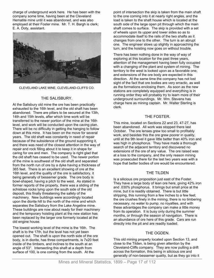
Mines and Mineral Statistics, 1899 – Page 17 of 112
charge of underground work here. He has been with the company some time, having been at the Cleveland Hematite mine until it was abandoned, and was also employed at their Foster mine. Mr. T. H. Bargh is clerk; E. A. Doty, assistant.
CLEVELAND LAKE MINE, CLEVELAND-CLIFFS CO.
THE SALISBURY. At the Salisbury old mine the ore has been practically exhausted to the 16th level, and the old shaft has been abandoned. There are pillars to be secured at the 13th, 14th and 15th levels, after which time work will be transferred to the newer portion of the mine at the 16th level, and work will be conducted upon the caving plan. There will be no difficulty in getting the hanging to follow down at this mine. It has been on the move for several years. The old shaft was constantly in need of repair because of the subsidence of the ground supporting it, and there was need of the closest attention in the way of repair and rock filling about it to keep it in shape for caring for ore and men. The company is right glad that the old shaft has ceased to be used. The newer portion of the mine is southwest of the old shaft and separated from the north run of ore by a dyke having a thickness of 365 feet. There is an excellent showing of ore at the 16th level, and the quality of the ore is satisfactory, it being generally of bessemer grade. The ore body is bowl-shaped, having a pitch to the west. As stated in former reports of the property, there was a sliding of the schistose rocks lying upon the south side of the old deposit, this finally threatening the safety of the machinery. New buildings were accordingly located upon the diorite hill to the north of the mine and which separates the Salisbury from the Lake Angeline mine. These buildings are now about ready for their machinery and the temporary hoisting plant at the new station has been replaced by the larger one formerly located at the old engine house.
The lowest working level of the mine is the 16th. The shaft is to the 17th, but the level has not yet been opened out. The shaft is upon the north side of the ore body, is in diorite, has three compartments, is 7x20 feet inside of the timbers, and inclines to the south at an angle of 53°. Intersecting this shaft at a depth from surface of 100, is one coming from the south. At the
point of intersection the skip is taken from the main shaft to the one coming into it at nearly right angles, and the load is taken to the shaft house which is located at the south side of the large open pit through which the main shaft comes to surface. The skip is provided with a set of wheels upon its upper and lower sides so as to accommodate itself to the rails of the two shafts as it changes from one to the other. The turn is an abrupt one. The engineer slows up slightly in approaching the turn, and the hoisting now goes on without trouble.
There has been nothing done in the way of way of exploring at this location for the past three years, attention of the management having been fully occupied with a changing of the plant and system of mining. The territory to the west is looked upon as a favorable one, and extensions of the ore body are expected in this direction. At the same time the company has not lost sight of the fact that ore bodies are very erractic, as well as the formations enclosing them. As soon as the new stations are completely equipped and everything is in running order they will probably try to learn more of their underground surroundings. Mr. Wm. Stevens has charge here as mining captain. Mr. Walter Sterling is clerk.
THE FOSTER. This mine, located on Sections 22 and 23, 47-27, has been abandoned. All work was stopped there last October. The ore lenses grew too small to profitably work, and besides this the ore grew poorer in quality, until at the 9th level it gave little better than 40% iron and was high in phosphorus. They have made a thorough search of the adjacent territory and discovered no extensions of the ore of any value. The ore raised was at a loss to the company, and the only reason mining was prosecuted there for the last two years was with a hope that better bodies of ore would be encountered.
THE TILDEN Is a silicious ore proposition just east of the Foster. They have a large body of lean ore here, giving 42% iron and .030% phosphorus. It brings but small price at the mine, but it is readily obtained. There is but little stripping, this running from a few inches to a few feet; the ore crushes finely in the mining; there is no timbering necessary; no water to pump; no royalties, and with these advantages the company can make a little money from its operation. It is busy only during the summer months, or through the season of navigation. There is an abundance of ore here of this grade. Cars are run directly into the pit and are readily loaded.
THE OGDEN. This old mining property located upon Section 13, and close to the Tilden, is being given attention by the Cleveland-Cliffs company. They are now putting a drift across the formation, this being in silicious ore and generally of non-bessemer quality, but as they go into it

Mines and Mineral Statistics, 1899 – Page 18 of 112
the phosphorus increases. They hope to find a silicious ore of bessemer grade. Last year Mr. E. F. Bradt, of Ishpeming, did some work here, but threw up his option, deciding it was not worth giving further attention.
THE MICHIGAMME. The Michigamme mine, located at the village of Michigamme, this county has not been worked since the Cleveland-Cliffs purchased it. It is a producer of hard ores of non-bessemer grade. The pockets are small and the ore expensive to secure. There was a trial at concentrating the lean ores here by electricity some years ago, but it was upon too small a scale to be successful. The mine is full of water.
The Cleveland-Cliffs has a large acreage of land well located upon the iron ore bearing range, and extends to explorers options to search them for mineral. Since deciding to give options nothing of importance has been found. Exploring is an expensive business, the diamond drill being almost a necessity in testing the formations. With carbon for the drills selling at $36 per caret, the average explorer is badly handicapped.
The Cleveland-Cliffs has fine mine shops, substantial buildings of stone, and they are equipped with modern machinery. The mine hoists, compressors, motors, etc., are of the best. Mr. Duncan and his assistants have accomplished a great deal here since they took hold. They are energetic and competent and under their direction the property will thrive. The mines are employing 1,250 men.
M. M. Duncan is agent; A. J. Yungbluth, auditor; Jas. Jopling, mining engineer; S. R. Elliott, assistant; Thomas Martin, clerk; F. J. Baker, chemist; Samuel Redfern, Negaunee, Mich., is agent of mineral lands of the company.
The main offices are at Cleveland, Ohio. W. G. Mather is president; J. H. Sheadle, secretary; R. C. Mann, auditor.
THE LAKE SUPERIOR IRON COMPANY Was the second to engage in the business of mining iron ore in the city of Ishpeming and the third in the State of Michigan. Its start was made in 1856 and its first shipment of ore followd two years afterward, so that it has been represented in the shipping tables for a period of forty years. In this time it has sent from its mines 8,260,713 tons, leading all other concerns in the Lake Superior region, and for the year now nearly closed has exceeded by 250,000 tons its former best record in any single season. This is certainly a remarkable performance and in its contemplation one will see that the properties of the company must have been intelligently handled in order to permit of such a business at the end of a forty-year career. While it speaks well for the past, it also must be favorable for the future, as 986,563 tons are not taken from mines that do not possess considerable producing area,
Of the prominent properties of the company from which ore can be taken are the Hard Ore, Old Mine Hematite, New Deposit, Section 16 and Section 21. All of these with the exception of Section 21 are within the corporate limits of the city of Ishpeming.
THE HARD ORE. It was at this point that the original openings of the company were made. There were prominent out-croppings which were readily located by the explorers, and these were followed downward from surface, the ore being mined from open pits, which was the method common at that time in the opening of mines where the ore occurred as it did here. The open pits were carried downward until it was disadvantageous to go further, when shafts were sunk and the mine wrought on the underground plan which has since been followed. These hard ore deposits occupy a position on the north side of a huge core of diorite which rises to a considerable height above the surrounding level. They are mixed with great "horses" or bunches of jasper and soapstone, are of varying shapes and sizes and considerable "dead work" in the way of rock drifting had to be done to locate them. The diamond drill was constantly employed and was a valuable aid in showing the miner where to drift from one lens to another.
The most westerly working is at No. 7 shaft, which is also the deepest portion of the company's mine, being to the 920-foot level. At this point, and to the north of the shaft, they expect to resume work in the near future, putting a few men on ore that is upon the property of the Iron Cliffs company, being the southern limit of their old Barnum mine ore. The Lake Superior has arranged with the Iron Cliffs to mine this, paying a royalty therefor. It is cut off from the old Barnum workings, which have long been idle, and could only be taken from the Lake Superior side. This ore is upon the 600, 640 and 680-foot levels.
In the east end of the 680-foot level there is a small lens of ore that will be mined. At the 720-foot the ore has all been mined out, and there is but little to be seen in the 760-foot. At the 800 and 840 there is a bunch of ore to the west and south of the shaft, close to the foot. The 880 and 920-foot levels are full of water. There are the floors and pillars in this end of the mine to be taken, a work which will not be engaged thoroughly in until the ground has been well exhausted of its stopes. There is a chance that small lenses may be added. The shaft is single-compartment, is vertical to the 800-foot level, inclining with the foot from that point to the bottom. The ore is non-bessemer, yielding about 65% iron.
At No. 6 shaft, to the east of No. 7, they are giving attention to but two points, one upon the 800, the other upon the 840-foot level. At No. 6, which is a vertical shaft, equipped with cage and skip, the men are handled in and out of the mine. They go to the 720-foot level, where there is a drift connecting with No. 7. Through this the water is taken to No. 7. Connection is also had

Mines and Mineral Statistics, 1899 – Page 19 of 112
at this level with No. 2, to the east. At No. 2 they are taking the pillars and floors, bottom having been reached in this portion of the mine. They are now working between the 480 and 440-foot levels. They are proceeding from the bottom upward. Pillars are undercut, sliced from the bottom upward, the open chambers having previously been filled with rock. Rock is run in to take the place of the mined-out pillars and floors as fast as a section has been cut out. Sometimes the pillars are strong enough to stand without cribbing in the act of slicing. As the rock settles wedges are used to take up the weight of the pillar, these being driven up tightly as the filling recedes. There has been but little trouble with this plan and the ore from pillars and floors has come readily. They work experienced men here, and a comparatively small number are employed. No. 2 is an inclined shaft, as is No. 3, next to it. At No. 3 they are taking the floor at the 320-foot level.
The filling is obtained from an immense waste dump on surface made years ago. The rock is milled through winzes into the levels. Generally it goes direct to the points where needed, but occasionally it has to be transferred underground.
The deepest level at No. 3 was the 520-foot. Up to within a short time since all the ore from this mine was shipped as non-bessemer. In the upper levels at the east end of the property they are finding bessemer grade, which is being selected. At the time this mine was opened there was little attention given to phosphorus. Everything was shipped as non-bessemer, and at a very fine price per ton.
There is considerable ore remaining in the old hard ore mine in pillars and floors, enough to give work to the miners at the present rate of production for many years. The company was liberal in its protection to the surface and to the miner. They went moon the safe side. The ore extends upward to the bottom of the open pit. The amount annually taken will not be large, but it will assist in keeping up the product to a respectable figure for some time to come. All the ore mined here is crushed at Section 16. Mr. John McEncroe is mining captain at the hard ore, and has been with the company forty years.
THE OLD MINE HEMATITE. The Old Mine Hematite, located a short distance east of the hard ore mine, is practically worked out. It was a shallow, deposit, wide and thin. They are doing something in the way of scramming, taking a little ore here and there, wherever it is to be found. For years it was a prominent part of the company's possessions, and the ore was easily secured, it being in shape for ready and economical mining. There is one shaft, "Cage,” located close by the county road which passes through the location.
An extension of the ore of this mine was found a few hundred feet to the east, and near the northwest corner of the old Lake Angeline basin. The ore here was overlaid by a heavy capping of rock, so that their first
level was started at a depth from the collar of the shaft of 320 feet. In places the ore made above this point, following the foot, and was successfully brought down. They are taking the ore on the caving plan, but as yet the thick capping refuses to follow down. It is said to slab off from the under side and is partly filling the space made by the settling, and there is little danger of trouble from its coming down with a crash all at once. In the upper portions of this deposit the ore carried considerable manganese. On top the ore made large, chokes up at about the 380-foot level, from which point it is widening out again. They are working between the 380 and 440-foot levels, taking sub-levels eighteen feet thick. They have cut out the 513-foot level, but are doing no mining there as they have not carried the work to this depth, they going from the top of the deposit downward. The shaft is to the 575-foot level, but the latter has not yet been cut out. The ore body here has a length of about 300 feet, it having been followed east to the Cleveland Iron Mining company's west line. Westward it does not reach the shaft, the latter being in hematite jasper, and is firm and substantial. In taking the ore from stopes to shaft they use the hanging wall drift, which is in hard ground. Power is used to take the cars to shaft, it being provided by a small portable hoist. The ore is generally non-bessemer, and it all has to be drilled and blasted, being very firmly in place.
THE NEW DEPOSIT. The "New Deposit," as it is locally styled by the miners, is one I have before mentioned. It lies 850 feet south of the No. 1 Lake shaft, and is connected by drift with the latter at the 300-foot level. The ore occurs in a fold of the diorite which rock forms the bottom of the old lake basin. The deposit was located with the diamond drill, and mining has been prosecuted for the past two years. They are winning the ore in the modern way, caving the surface, cutting up the ore with sub-levels, using light timbers in the drifts and lagging the bottom of drifts so as to take up the gob overhead when the settling of the overlying burden takes place. Over the ore there is a considerable thickness of mud, the latter covering the entire lake bottom and. being a menace to mining. They began work near the west shore of the old lake basin, and have for some time kept this end of the mine lowest so that the water would be taken up by the sand of the old lake bank. This worked finely while the water was coming down thickly in the opening of the deposit, but gradually the water has grown less until now there is little to bother in the mine, the surrounding formations having been well drained of moisture.
The ore here is not of great thickness, the drift from the 300-foot level of the No. 1 shaft having cut a few feet under the bottom of the lens at that point. In point of quality it is generally excellent, much of it being high grade bessemer. It is not a big find, but it takes the place of some of the old deposits that have been exhausted. Since my last report upon this mine they have made some gains. In the original work of putting

Mines and Mineral Statistics, 1899 – Page 20 of 112
down the diamond drill holes they had found what they thought was the eastern end of the lens. Two holes were bottomed in decomposed diorite without finding ore. It certainly looked as if the end of the ore had been located. The present management thought it advisable to do a little exploring in that direction, however, and a horizontal boring was made from underground in the mine. This cut through seven feet of soapstone when ore was encountered and followed for a distance of several hundred feet. Had the holes from surface been four feet either side of the line followed they would have struck the deposit. As it was they went down in a seam of rock seven feet thick, and almost exactly in the center of it. The rock was a tongue that made almost directly across the strike of the mine. The addition is certainly a promising one. Enough has not yet been done to determine its real value, but it would not be surprising if it connectes with the Angelina deposit of the Cleveland company, which lies upon the southern side of the basin. They have followed the ore for some distance upon the upper level, the 175-foot, and from the 300-foot are in about 140 feet. This gives a very nice length to the deposit here, and will assist materially in the securing of a product for some years to come.
LAKE SUPERIOR IRON CO.’S LAKE SHAFT.
The west end of the New Deposit is now being worked at the 225-foot level, and in the east end they are taking the ore from the upper level, the 175-foot. The ore is milled to the 300-foot level and from there taken to the No. 1 Lake shaft by power. The train of cars runs by gravity to the shaft and is pulled back with a small hoist. The grade is one foot to the hundred, and the cars run out freely and rapidly. It is an inexpensive device and does the work satisfactorily. At the east end of the mine the 300-foot level has not been extended sufficiently far as yet to take the ore from the levels above, but it will be pushed in that direction as fast as possible so as to facilitate the handling of ore from that end of the mine.
The work done at this mine must be of a highly gratifying nature to the company. There has not been a moment's delay since the caving of the surface was inaugurated. It has been the aim to bring the top down evenly, and this has been accomplished. The mud has not shown itself anywhere. This certainly reflects much credit upon Mr. Johnston and his able assistants. The accumulation of "gob" above the miners affords protection from the mud.
The latter has a consistency of thick cream and would readily come into the mine workings were there any openings through which it could find entrance. It would seem that there is to be no difficulty on this score, as enough has now been done to care for the top.
There is a timber shaft at the west end of the mine, in solid ground, where timber is sent down and where the men could get out in case of a shutting off from the main outlet, which is not at all likely to happen.
SECTION 16. This property adjoins the Lake Angeline old mine immediately upon the west. It is not looking well at this time. The deposits of ore upon which work was originally done here have pinched to small proportions and in places have given out altogether. In this mine there is a dike of dolorite 130 feet thick crossing the strike of ore, dividing it into what they call their "north vein" and "south vein." On the north vein the ore has pinched out, and the work now being done is confined to the taking of pillars. The mined-out portions are being filled with rock sent down through an old inclined shaft to the 350-foot level. A pillar extending from the 350- to the 450-foot level is now receiving attention. The ore sent from below the 350-foot level is milled to the 430-foot where it is trammed to the main hoisting shaft.
On the south side of the dike they are working upon the 430- and 530-foot levels. The ore here is a non-bessemer, but is improving somewhat as they sink upon it both in size and quality. In the upper levels of the mine hard ore was found, but at greater depth this is replaced with soft hematite, this being the usual occurrence in this section. The softer ore invariably lies beneath the hard. From the 530-foot level they have raised to the 480.
From the 530-foot level they are putting in a drift to the south, it now being about 500 feet in that direction. They are in vein matter, a distinct foot and hanging wall being seen. From surface there is exploring being done, the line of holes being west of that of the drift. As yet nothing of importance has been encountered. One of the holes is 930 feet in quartzite. The territory is one in which ore should be discovered. They will probably keep the drill busy for some time, or until this portion of the property has been thoroughly tested.
From the 630-foot level they are driving to the south to reach the same ore found in levels above upon that side of the crossing of rock.
At the 680-foot level the hard ore vein is practically exhausted. At the 730-foot level no hard ore is seen, but the hematite takes its place. It gives from .050% to .070% phosphorus.
There was a hole directed towards the north against the big diorite hill which forms the foot wall of the old hard ore mine on the north side of the hill, but the formation was so badly broken that the hole caved, and nothing more could be done with the drill. This is looked upon as
Mines and Mineral Statistics, 1899 – Page 21 of 112
one of the promising points for exploration, as soft ore ought to be found here.
While the location is a favorable one to the existence of rich bodies of ore it is just now a field for exploration rather than of mining. The hematite, which is coming into the bottom of the mine, and improving a little in size and quality with each added level, may make into something important, but that is speculative. If ore is found to the southwest, it will be deep, as the pitch of the mine is quite sharp in that direction. The thickness of the quartzite indicates that if ore is found it will be deep-seated.
Captain James Trebilcock has had charge of underground affairs here and the hematite mines for many years.
SECTION 21. This is a producer of non-bessemer, located two and a half miles south of Section 16. It has an abundance of ore of the grade here obtained. In the extreme eastern end of the mine they are giving attention to ore tributary to their Mitchell shaft, the most eastern, and are working upon two levels, the most extensive operations being upon the 580-foot. They go to the limits of the deposit and cave it, working back towards the shaft in the manner I have heretofore described in reports of the mine. They have just commenced the work upon the 640-foot level, the deepest in the mine. They keep well ahead of work in the bottom level in the one above it so there will be no danger to the men. The ore is taken by mules and horses to the shaft. Thus far they have used one mule and two horses. The horses will soon be replaced by mules, two now being worked upon surface and will be sent into the mine. This sort of power gives perfect satisfaction, it being economical and sure. The animals show surprising intelligence in the work, quickly learning what is wanted of them. The tramming is done upon the lowest level of the mine, to which the ore from above is milled.
The best ore found here is at the company's East shaft, which is west of the Mitchell, and not far from the old No. 1 Winthrop. Since my last report this portion of the mine has been connected with the West shaft, 1,100 feet distant. The connecting saves several hundred feet of tramming, the ore now being sent to the West shaft. At the East shaft but little is now being done, attention being given to the taking of a pillar.
To the west and north of the West shaft there is a large body of ore through which tongues of hematite jasper occur with considerable frequency. There is also a mixture of quartz which breaks into small pieces in the mining. It is impossible to separate it from the ore and this has the effect of lowering the percentage of iron in the ore obtained at this point. The footwall is very irregular, and there is also a probable swinging to the south as they proceed westward, conforming to the contour of the diorite hill upon the foot side of the mine.
East of the West shaft there is a separate lens of ore. In this they have raised from the 350- to the 200-foot level. This ore is free of the quartz, and by mixing with that from the extreme western lens it brings the quality up to the guaranteed point. The ore upon this side of the shaft runs from 30 to 50 feet thick. In many places in the western portion little or no timbering is needed to keep the drifts open, the ore being hard and the walls very firm. The mine is a model one and is given excellent attention by Captain John Trebilcock. It has not been steadily worked, there having been several stoppages since it was first opened. Should there be a better demand for non-bessemers a considerable addition can be made to former yearly outputs.
Nearly all the work done underground is upon the contract system. At Section 21 a trial of the eight-hour day is being made, the men having agreed to do as much as in the former ten-hour day. Eight hours constitutes a day's work at the other soft ore mines of the company.
The Lake Superior is admirably equipped in the way of mining machinery. The plants are modern and economical. The hoisting for the hematites and hard ores is done from No. 1 engine house, it being the object to centralize the power as much as possible. At this station there are four 12-foot drums and two 8-foot. At No. 7 hard ore, there are two 5-foot drums. One of these is used for handling the cage at No. 6 shaft. At the hematite there is a 4-foot drum for the handling of timber and for sinking. At Section 16 they have two 8-foot drums for the mine and two 5-foot for conveying ore to the crusher. At Section 21 there are four 8-foot drums located at the West shaft.
The mine shops are built of stone and are equipped with excellent machinery. Mr. James Clancy, master mechanic, has been with the company twenty-four years and is invaluable to them.
At Section 16 is located the crusher, a Gates, put in during the last year. It is the first of the kind to be put at the hard ore mines of this district, and thus far it has given perfect satisfaction. I believe its performance is ahead of any other crusher in the region. It is substantially built, has 18x36" openings and dimensions of all receiving openings are about 18x126". The weight of the breaker is 90,000 pounds. The capacity is equal to whatever amount of ore can be sent to it. They have crushed 1,700 tons in ten hours, breaking the ore to about three inches. There has been little expense for repairs, and the original cost of the machine is considerably less than other forms of breakers being used in this region. It treats the ore from all the hard ore mines. Could the hopper of the breaker be kept full always it would do even better than at present, but with two skips taking the ore from the pit just below the level of the ground below the breaker, a distance of something like fifty feet, the machine is not given one quarter the material it can dispose of, so that it is running without ore the greater part of the time. A duplicate of

Mines and Mineral Statistics, 1899 – Page 22 of 112
the Gates crusher at Section 16 has been put in at the hard ore mines and is now ready for business.
The company added another steam shovel to its equipment during the year a Barnhart, model G, and one that has proved very satisfactory. They worked it steadily during the shipping season and did not spend a cent upon it in the way of repairs. The company now has three shovels, and is well supplied.
There is a well-fitted laboratory, Mr. W. H. Anderson being head chemist. Many determinations are made daily owing to the large number of grades of ore mined.
The location is a neat one, everything being well kept up. Mr. James McKutcheon has charge of affairs above ground, being surface foreman.
The Lake Superior owns about 175 dwelling houses and has nearly 19,000 acres of land. It is employing at the present time 1,150 men. Mr. J. C. W. Chipman is cashier; J. D. Sliney head clerk.
On May 8 the property of the Lake Superior Iron company was transferred to the Oliver Mining company, who purchased a control,—70,000 shares out of 84,000, for $45 per share. No change has yet taken place in the local management.
LAKE ANGELINE MINE D SHAFT.
THE LAKE ANGELINE MINE. The city of Ishpeming would miss the Lake Angelina mine of the Pittsburg & Lake Angeline Iron company were the latter, from any cause, to suspend operations. It has been a popular property, and still is. It has been liberel in its treatment of labor, has freely assisted in all municipal improvements, and at the same time it has not forgotten its shareholders. While the figures are not obtainable showing the amount of earnings distributed, it can be safely said that the company is at the head of all others engaged in a similar business in the Lake Superior region if not in the entire world.
And the Lake Angeline ore deposits are not of those immense proportions as the earnings of the company might suggest. There are many properties in this region possessing larger. The ore has averaged of favorable quality, it is true, but this has been assisted by the most careful determinations on the part of the chemist and engineers and underground foremen. It has ever been the aim to keep the grade up to the highest possible point and in this way to receive the highest market price for the product. Again, the mine and everything connected with it has been admirably managed. Mr. Alfred Kidder, the agent, and Thomas Walters, superintendent, are thorough mining men who have had long years of practical experience, who have taken advantage of every condition supplied by nature, and who have been progressive in the introduction of artificial ones.
Nowhere I have visited is mining better done than here. In every foot of the way underground there is evidence of able direction. The levels are nicely cut out, are roomy, well ventilated, and the safety of the miner has been carefully considered. This is well attested to in the remarkable freedom from fatalities. And the company secures all the ore. Practically, nothing is lost. The caving plan, first inaugurated in the region at this place, is worked in its best form, and the cleanest possible taking of the ore results. The plan is one being now generally observed in the working of soft ore hematites in the Lake Superior country. The company has made no changes in the system since its first introduction here. They carefully figured out how it could be best done and as yet have found no need of a change. It is the best plan for the taking of the ore so that none will be lost, and is also better for the miner, it reducing the danger of accident from falling ground to the minimum. The management has surrounded itself with an excellent lot of assistants who have long been engaged here, who are skillful and loyal. The miners and other workingmen are of the best to be found in this district. The company has always paid the highest wages, has permitted men to earn all they can, and this has attached the best class of labor who are willing to work hard, knowing they will be compensated according to what they accomplish. The company extended its employes an eight-hour day many years ago, and are well satisfied with the result.
The Lake Angeline mine workings extend eastward from the Section 16 mine of the Lake Superior Iron company, the ore following the north side of a huge outcropping of diorite which has an east and west trend. The company has four forties m the northern portion of Section 16, the ore lying very close to the northern line of the company's possessions. One can easily throw a stone from the company's north line to the southern limit of their ore, and the length of the ore deposit would be covered by three forties. They have reached the bottom of the trough in which the ore is held, and it is not a difficult matter to figure the millions of tons that are yet to be extracted. While this is true, the Ishpeming people and those who own shares in the mine need not be

Mines and Mineral Statistics, 1899 – Page 23 of 112
apprehensive of the future of the property, as there are many years' work in sight. Still, the end can be figured.
In the western end of the property the bottom of the trough has been reached by the miners, and ore now being obtained is coming from the old pillars and floors left for support in the original opening of the deposits. An exception to this is to be found in the extreme western end where there is a lead of hard ore north of their hematite workings, and connected by drifts to the latter. Here they will follow the ore in its western pitch with an incline slope, as far as their western boundry, where it makes upon lands owned by the Lake Superior, and where it has already been mined upon that side of the line. They struck this ore between the 6th and 7th levels, raising from the 6th to it, and there is also a raise connecting the 6th with the 7th. The ore is milled down to the 7th, from which level it goes to the shaft. The ore has been raised upon nearly to the surface sand, and there are several big pillars left that will be taken, and which will require a few seasons to obtain. This ore will assist in keeping up the product from this end of the mine for a few years, and has been important for the season just closed. The ore is crushed at C shaft. At this end of the mine there are several railway tracks upon surface, and there is also the county highway to be protected. It may be that the company will decide to fill the open chambers in the hard ore workings, and to take all of the pillars in this way, replacing them with waste rock from surface. If this is not done the pillars can only be "thinned" to a point where they will be still of use in protecting the surface from coming into the mine.
In the older workings at this end of the property they are to the 8th level, 470 feet from surface, and the work consists in the taking of pillars and floors. There is a big pillar supporting C shaft which will soon be attacked. The same condition prevails at D shaft, about 800 feet further west. To secure the ore of these pillars a new shaft has been sunk 1,300 feet from the west line of the property, and nearly midway between C and D. This has been finished and is now in commission. It reaches to the bottom of the mine; the 7th level, is vertical, has two skips and a man way. Two drifts have been put through the diorite foot wall on the north side of the deposit, one at the 4th, the other at the 7th level. These are each between 1,700 and 1,800 feet long. The sinking of the new D shaft and the putting in of these drifts with the necessary crosscuts to reach the ore was all done during the past year and was a great deal of "dead work" for one season. The ore here occupies a trough made by the folding of the diorite, the bottom of the fold being V-shaped, so that there is really a footwall upon both sides of the deposit at its lowest points. The drifts are in substantial ground and through them the ore is conveyed to the new shaft by two electric motors. These are similar to the motors used in the East End mine of the company, often described, and besides them there are others to take care of the ore upon surface, tramming it from the shaft to stockpile. These motors are the manufacture of the General Electric company, Chicago.
There are now six 6-foot drums at the engine house providing power for the old mine. Four of these will be discarded as soon as the old shafts are abandoned, two being ample to care for the product at the new shaft. There is also a Cornish lift pump which will be removed and its place taken by a Prescott steam pump, compound condensing, with a capacity of 700 gallons from the bottom of the mine per minute. They have cut out a big fork here for the water and can get along with about two days' pumping in the week when this is ready. The mine makes but little water. The Corliss engine now used on the old plunger will operate the hoist at the new station. The plungers are for sale.
The sinking of the new shaft has necessitated a shifting of the mine shops to give place for stockpile ground. The company is much crowded for room, and has been forced, upon several occasions, to move their buildings to give room to shafts, tracks and ore. Altogether, a great deal was done in the way of new work at the old mine during the year. The year previous a railway track was constructed from the East End mine to avoid caving ground, the expense being considerable. Despite all this outlay the company has done well financially, and they expect that little more in the way of surface changing will be needed from this time on until the deposits have been mined out.
In the East End mine they have been working upon the 2nd level most actively, although considerable has been done upon the third. In the extreme eastern end, where at the time of our last report they were taking a little ore extending above the first level, they are now doing nothing, the work having been transferred westward several hundred feet. The pitch of the ore is to the west and they are gradually gaining ground in that direction. Further east there is a portion of the basin formed by the folding of the diorite, but nothing of value has been found. They tested the ground thoroughly with diamond drill borings. To the north of them a short distance, and upon the northern slope of the fold, the Cleveland company mined 70,000 tons of high-grade ore, but it did not extend into the valley to the south where one would most expect to find it.
In the East End mine they carry levels seventy-five feet thick, and another level under the third will be below the bottom of the ore at this point. As they go west the ore makes deeper. Lying upon the ore deposit here is a capping of silicious ore, wedge-shaped, with the thinner edge of the wedge entering the better-grade ore. This lean ore gives from 44% to 45% iron and runs a trifle over .001 % of phosphorus to 1% of iron, being very close to a bessemer. From this lean ore capping 10,000 tons were taken during the year. It has not yet broken down so it can be as cheaply secured as it will in time, after it is weakened by the mining underneath and breaks up. There are several millions of tons of silicious ore in this immense capping, and after it has settled down upon the openings beneath it can be easily secured. The price obtained for this ore is 40 cents per ton at the mine, loaded upon cars, so that it must be

Mines and Mineral Statistics, 1899 – Page 24 of 112
taken on a large scale in order to insure a profit from its mining.
As yet they have not reached a level in the mine workings below the lowest point of this intrusion of silicious ore. Thus far the clean deposit has been divided into two bodies known as the "north vein" and "south vein." Another level will find these north and south deposits merged into one by reason of the absence of the silicious capping, and this place will show the biggest deposit in the mine in the way of ore. As the ore goes west upon its pitch it also has a northern dip which carries it across its line and upon territory owned by the Cleveland Iron Mining company. The Cleveland is now working upon the extension of the Angeline deposit. A diamond drill hole put down near the line dividing the two properties shows the ore to have a thickness at that point of over 160 feet. This ore is of the finest grade bessemer. The ore of the East End mine is for the greater portion bessemer grade, about 80% of it being put into that class by the most careful system of analyzing and selecting. It is a fine blue ore, very firmly in place in the deposit, power drills and explosives having to be freely used in winning it.
The fourth level will be the lowest principal one here. The ore in the western end of the mine will probably extend to a lower depth, but they will reach this by an inclined slope running from the fourth level, following the dip of the deposit to the west. There is one hoisting shaft located at the eastern end of the property and upon the north footwall. Upon the opposite side of the mine there is a shaft through which timber is sent, it being worked in balance, a dummy counterbalancing the loaded timber cage. One man regulates the descent of the load, a simple wooden brake being all that is thus far needed to control the speed of the cage.
A few hundred feet from the southern side of the mine, and about mid-way upon its length, a flat deposit of ore was located a few years since. They will connect this with the mine by drift and send the ore down to the tramming level. There are a few thousand tons of it, and it is of wonderfully high grade. Leaner ore is showing at the south edge of the mine where the depression caused by caving surface is seen. This may be given attention later on.
The electric motors are still used and give perfect satisfaction. There have been no accidents through their use and the repair account is trifling. The ore is quickly handled through the level, and one motor is kept busy hoisting timber through the raises for the use of the miners. The men pay a certain price for this service, and are right willing to do so, as it saves' them time as well as money. Those who were somewhat prejudiced against the motor handling the timber at the outset are now loudest in their praise of it. The motors are also used on stockpile.
At the East End station there is the electrical machinery, compressor and a pair of 8-foot hoisting drums. This is adequate for the future needs of the mine. It is a very
busy station, as the greater portion of the ore shipped by the company comes from here.
Between the East End mine and the old mine there is a stretch of ground upon which some exploring has been done. One diamond drill boring found silicious ore and there may be a chance for something better. In the upper levels of the new mine there are several leaders coming in from the west, and they have been following these in the hope that they may make into something of value, but thus far nothing important has been found, There is a heavy dyke cutting across the strike of the mine further west, and there may be a chance somewhere near its eastern limit for ore to make. It will not be a very difficult matter for proving this by drifting from the levels of the new mine in that direction. Southward there is no chance for ore as a huge belt of diorite occupies the balance of their territory going in that direction, and is for the most part seen rising a considerable distance above the surrounding country. If ore is to be found upon the company's lands in this city it will be on the strike of their present mines and within the narrow confines of the northern side of the big bluff and their northern boundary line. The company owns property adjoining the Winthrop Iron company, three miles south of Ishpeming, and found lean ore in several pits sunk last year. No high grade ore has been shown on these lands although it may be there. There is an abundance of silicious hematite running about 40% in iron, but from the mining and sale of this little could be secured in the way of dividends.
The total shipments for the mine for all seasons amounts to 4,645,866 gross tons. Of the 460,333 tons sent out this year 12,193 were by all-rail, 10,000 tons being sent to the Gladstone furnace.
The company owns a half interest in the Lake Superior & Ishpeming railway, the principal business of which is transporting ore from the mines of the Lake Angeline and Cleveland-Cliffs company from Ishpeming to Marquette. A passenger service is maintained only throughout the summer months.
The company has well-equipped shops for doing new work and for repair. Richard Smith is master mechanic, William Belcher, head blacksmith. George M. Baker is electrician. In the office George R. Persons is cashier, Charles Kruse, head accountant.
The local officers are Alfred Kidder, Marquette, agent; Thomas Walters, Ishpeming, superintendent; E. F. Bradt, mining engineer and chemist: William Tregambo and W. H. Downing, mining captains. The general officers are: James Laughlin, Jr., Pittsburg, Pa., president; W. G. Pollock, Cleveland, O., secretary and treasurer.
EAST NEW YORK MINE. This property is located on Section 2, in the corporate limits of the city of Ishpeming. It has received much attention in the past by various operators, and has

Mines and Mineral Statistics, 1899 – Page 25 of 112
produced 166,243 tons of ore. It has been idle for several years, but is at this time, June 1, '99, being revived by Mr. E. F. Baird, of New York, who is concerned in iron mining and smelting in his native state. Frank Plat to, of Ishpeming, has been placed in charge of the work. The old mine will be pumped out, and active explorations begun as soon as possible. The mine produces soft hematite, the greater portion of which is non-bessemer.
To the east and north explorations under the name of Iron Valley, Ames and Brass Wire have been conducted, and something like 10,000 tons of ore secured. The location is considered a favorable one. Mr. M. A. Bigelow of New York city, is owner of the fee.
THE CHAMPION MINE. The Champion iron mine is one of the most interesting of the long list in the Lake Superior region. It differs from most others in possessing a true vein, and it has also been followed to a greater depth than any other unless it may be the Republic, its lowest workings being about 1,500 feet vertically from surface. For the 3,000 feet upon the strike of the formation which have been opened in following the ore from the most eastern point at which it originally oucropped to the present farthest underground opening to the west, the walls of the mine have been regular and the ore readily found. The dip of the vein is nearly vertical, it having a slight inclination to the north while the pitch is west about 65°. Through the central portion of the mine there was encountered a large barren area which has held downward persistently, and there were also two parallel veins of ore in the eastern portion of the mine. The one to the south has given out and they have done nothing upon it for several years. Nine shafts have been sunk, and all but three of these have been abandoned. The active ones are in the western end of the mine.
No. 7 shaft is the one attracting most attention at this time, and it is important to the company for the reason that it is this direction that the hope of future product lies. No 7 is located 400 feet east of the company's west line and 400 feet west of No. 6. It is a fine two-skip shaft. It follows the dip of the vein to the 12th level where it ran into the ore and it was decided to change it to a vertical position which has been followed from this level downward to the bottom, the 20th level. At the 19th level a little ore was encountered in the shaft which is looked upon as a faint sign that the south vein, found further east, may come in again. It would be a most acceptable addition.
Mr. Fitch, the company's agent, a gentleman who has made an excellent record in the conducting of the affairs of the company, has decided to give No. 7 a spiral turn, beginning at the 19th level. At this level the shaft bears 18° west of north and it is proposed to so change its course that it will bear 62° west of north, the completed change to be made in a distance of 175 feet from the 19th level, which will give an easy turn and one that will
be practicable in the operation of the skips. Mr. Fitch has figured this all out, and to avoid any possibility of mistake had a model the full size of the skip track constructed upon surface, where all the detail was perfectly arranged.
The object of this change in the direction of the shaft is to follow the ore downward upon its westerly pitch of 65°, thus avoiding the sinking of another shaft. Looking at the map of the mine it is readily seen how two shafts, following downward in the foot and directed west to agree with the pitch of the ore could have taken all the product of the vein. The strike of the vein has been very regular as well as the dip, and it would have been an easy matter to have taken all the ore with two instead of the many shafts. Of course this could not have been foreseen at the time the shafts were started. All this has been revealed in many years' working of the deposits, but now that it is so apparent Mr. Fitch has determined to take advantage of conditions as they exist, and the first spiral shaft in the Lake Superior mining regions will soon be added to the long list of creditable achievements in progressive mining in this district. There are back stringers carried down through all the shafts, and even should a wheel leave the rail for a moment the back stringer would be immediately engaged so as to insure the skip's remaining upon the track. In case of necessity the shaft could be enclosed for the distance where the turn is made so as to effectually prevent the skip getting out of its course, but this is not thought to be needed. At any rate, the spiral shaft will be made and there is no question but that it will work satisfactorily.
No. 7 was sunk from a little above the 18th level to the 20th the past year, the openings at the points given attention being satisfactory in the amount of ore revealed. The same eccentricities of ore formation are observed in this shaft as in many other points in the mine. The following will serve to illustrate: At the 16th level the crosscut put in from the shaft across the vein showed 44 feet of ore. At the 17th level the ore had a thickness of 53 feet. At the 18th it was 60 feet across the ore, while at the 19th the ore had cut out entirely. In many places there is a sudden "stepping off" or benching to the west. To the west side of the crosscut at the 19th level, where the miners are now working, the ore is apparently coming in again, and will probably show excellent dimensions after more headway has been gained in that direction. The showing at the 18th is an excellent one in so far as quantity of ore is concerned, it reminding one of the fine stopes enjoyed in the earlier history of the property, but a feature giving the local managament considerable uneasiness is the fact that much of it is proving to be of non-bessemer grade. This is surprising, as heretofore the Champion's product has been wholly of bessemer grade, all of the many classes shipped being well under the limit as regarding phosphorus. This chemical change was first encountered two months ago and gives considerable annoyance. While small bunches of ground have been occasionally met with in which the phosphorus was high

Mines and Mineral Statistics, 1899 – Page 26 of 112
they were quickly worked out and ceased to give trouble. The improvement underground would be an excellent one but for the trouble mentioned, and it is hoped it will soon give way to the ore of the high standard formerly produced here. This would give about 65% iron and .045% phosphorus.
Besides the sinking at No. 7 and the stoping done at the several levels being worked, they have drifted from the 9th level west to the boundary line of the property, a distance of 900 feet. This drift was carried in the lower side of the hanging wall quartzite, the latter being decomposed for a few feet upon the under side where it comes in contact with the jasper, this making the work of drifting comparatively easy. From this drift they will put in diamond drill holes at frequent intervals to test the ore measure. Holes will be from 100 to 200 feet in length. It is the intention to put in similar drifts from the 16th and 24th levels, the idea being to test the ground at 500 feet, 1,000 feet and 1,500 feet from surface, these being the relative distances of these levels from the top of the shaft. The work of sinking goes steadily on and the spiral completed the shaft will follow down with the pitch of the ore lenses which will obviate the sinking of new shafts to the west. The lands adjoining the Champion on the west are owned by Mr. Fitch, and if they contain ore the company will receive any benefit that such possession may give.
No. 6 shaft is idle, having been abandoned since my last report of the mine. There are the floors and pillars to be taken from which a considerable product can be secured. The ore will probably be sent to the 20th level, taking it from the bottom of the mine upward, protecting the miners by a substantially timbered drift upon the level to which the ore is drilled down, as has been the practice in the older portions of the mine to the east, and often described in my reports. The ore near the present bottom of No. 6 pinched out and if a continuation of it is found will probably be to the west in No. 7.
No. 5 shaft was sunk from the 24th to the 26th level the past year. From the 24th to the 25th level the distance is 100 feet, and between the 25th and 26th levels it is 125 feet, this lower point exceeding 1,500 feet from surface. From the 12th level of this shaft an exploring drift has been carried west to within 250 feet of the downward line of No. 7, the latter point being 950 feet west of No. 5. At the 20th level a drift is now within 75 feet of No. 7. They are now taking 125 feet in a lift so that four lifts will add 500 feet to the depth of the shaft. When they have reached a point under No. 7 they will assist the work at this point by putting in a gang of men to raise while others will continue the drift westward. This is a most important work, as the drift will be of great value in determining what the ore measure holds at this depth and to the westward of the present workings of the mine. Should the ore occurrences correspond with what has been developed thus far in the property there should be a fair chance for the finding of excellent bodies to the west. The increase in the size of the stopes at the lower levels of No. 7 shaft is particularly encouraging for the
realization of the hope of finding something valuable in the western territory.
At No. 4 shaft nothing has been done since last September, at which time an accident occurred that effectually closed this avenue from the 8th to the 20th level. The hanging was a weak one, and orders had been issued that no one should travel through the shaft. When the back gave way it cleaned out everything to the 20th, cutting the skip rope in two and carrying the skip down ahead of it. Previous to this time for several years they had been taking the old floors and pillars. They will go around the shaft from No. 5, building a pocket between the 15th and 16th levels to which the ore will be run. A power tram with automatic dump will be employed to facilitate the work, and it is expected that the product will be secured at less cost than before the cave occurred. There are several seasons' work in taking this ore, and it will be of assistance in keeping up the product of the mine.
A trial of the eight-hour day was made in connection with the work at No. 5 shaft the past year. The company were desirous of hastening the sinking and drifting at this point and decided to try three eight-hour shifts. It proved most disappointing. In the drift the gases from the blasting had a very injurious effect upon the men, the fumes from the burning dynamite causing nausea, headache and dizziness. They employed a Sturtevant blower with eight-inch pipe to take the smoke and gases from the drift, but even this did not prevent sickness. They blasted three times in twenty-four hours, whereas they blasted but twice in the same time under the ten-hour day. Under the ten-hour plan there was time for the gases and smoke to escape, but in the eight-hour day, even with the time for dinner, there was no chance to clear the atmosphere from the powder smoke. Men would fall fainting beside their machines and several times the machines were pulled down by the men in falling so that slight accidents occurred. The men worked hard and made good wages, but they were in wretched condition, nearly all of them being unable to eat heartily. They were glad when the experiment was concluded.
The conducting of the ore from about the old No. 4 shaft to No. 5 will centralize the work of hoisting to Nos. 5 and 7, which will be an advantage of considerable importance.
There has been no change in the system of mining. Underhand stoping is the style generally practiced. There is no timbering to hold up the hanging. The walls are generally very firm. There is but little water. At the 17th level of No. 5 shaft there has been installed a fine duplex triple-expansion, compound condensing Worthington pumping engine. The discharge pipe is 4 inches diameter. They use the workings of the old mine for a sump and can store 3,000,000 gallons if desired. This does away with the necessity for an auxiliary engine, as the pump will take care of all the water the mine will make for three weeks. As it is the pump is worked but a small portion of the time. The pump is fed

Mines and Mineral Statistics, 1899 – Page 27 of 112
through three diamond drill holes in each of which a pipe is driven which has a valve connected with it. The flow of water can be regulated as desired. The shafts make no water, the latter coming from surface.
Between No. 7 and the crusher plant located at No. 6 they have changed the level of the trestle over which the ore is transported from the shaft to the crushers. The ore cars are now drawn to the crushers by power and run back to the shaft by gravity.
At the crushing plant they are putting in a conveying table to assist in the work of selection. There are occasional pieces of rock which escape the eyes of the miners underground and get mixed with the ore. The table is 43"x4’ and it travels ahead, it has also a side-jigging motion, this showing the contents of the table to the selectors to the best advantage. There have been no additions to the machinery with the exceptions of the pump and a small drum for taking the ore from No. 7 to the crushers. The mine is magnificently equipped with machinery of all kinds needed for the facilitating of underground and surface affairs.
The United States geological surveys of the territory embracing the Champion mine formations shows a minor fold of the ore-bearing formation about a mile north of the mine. If the quartzite here shown be the older, as the geologists have mapped it, there might be a fair chance for the finding of ore. It has often been described as a subsequent formation. Mr. Fitch will give the governmental experts the benefit of the doubt and will do something in the way of exploring along the strike of this belt. He will put a diamond drill on the company's lands in that section at an early date. This will be nearly on a line with the strike of the Michigamme mine, located a few miles to the west.
A few cars of magnetic ore masses continue to be sent to New York city where they are sawed up for anodes in the securing of chlorine. The mining has to be attended with much care to prevent fracturing of the ore, and they are not anxious to work up a bigger trade than now enjoyed for this material. The anodes are a success from the manufacturers' point of view, but the mining company cares little for the orders. They are simply accommodating the New York gentlemen. The magnetic ore slabs take the place of platinum, and besides being much cheaper are practically indestructabte, whereas the platinum soon became useless.
In my last report of the Champion Mr. Fitch estimated they would mine 160,000 tons for 1898. The tonnage sent out was 163,190. This would have been exceeded, however, but for the accident to No. 4 shaft. Two grades of ore are now made instead of the many of a few years since. The first quality, as I have stated, gives 65% iron and .045% phosphorus, the second grade gives 56% iron and .045% phosphorus, the latter element having been generally very steady in all classes of ore. The company produces slate, specular and magnetite. The mine has produced in all years 3,484,504 tons.
It is a pleasure to note any improvement in the ore bodies of the Champion. The mine has long been important in the history of Marquette county. It has been liberal in its treatment of those who surround it. Its location is a pleasing one, high, dry and beautiful from a scenic point of view. It has an excellent class of labor and the village is made up of good citizens.
Walter Fitch, Beacon, Mich., is agent; G. S. Barber is in charge of the surveying and laboratory, and is assistant to Mr. Fitch. The general offices are in Boston, Mass. Henry H. Fay, president; W. E. Stone, treasurer; W. B. Bosson, secretary.
THE REPUBLIC MINE. The bright little village of Republic is wholly supported by the Republic mine, the operation of this property furnishing the only source of employment for the workingmen of this place. Years ago there were other mines, small ones, in the near vicinity of the place, but these have been inactive for some time. There used to be considerable business, also, with the lumbermen who were engaged in the adjoining forests, but the timber has nearly all been felled and removed, so that now the Republic mine alone remains to give the cheer of pay-day and to furnish means for paying the grocer.
The Republic has been steadily wrought since 1871, and in this time has sent to market 4,643,040 tons of ore. For 1898 its shipment was 140,312 tons, and for the year previous it was 124,342 tons. The quality of the product equals that of the best iron mines in the Lake Superior district. Its ores are now almost wholly of the specular class, the grades and merchantable quality being as follows:
In the earlier history of the property there were big lenses of magnetic met with, and a considerable portion of the annual shipment was made up of this ore, but of late years it has almost entirely disappeared. The No. 3 ore is from the old waste dumps from which about 1,200 tons were shipped last year. It was to treat the ore in these waste piles that a concentrating mill was erected by outsiders a few years since and which was given up as unprofitable after considerable time and money had been spent in experimenting. There is ore to be had in these old waste piles, but it is not as plentiful as figured by those who leased the dumps. The piles have reverted to the company.
For the first few years of its operation the ore of the Republic was secured from large open pits, it coming to surface and lying advantageously for mining in this way, but now all work is done underground and has been for many years. In the southwestern end of the property, where mining was first begun, and where there were fine deposits in what are locally known as the Ely, Pascoe and Morgan pits, nothing is now being done with the

Mines and Mineral Statistics, 1899 – Page 28 of 112
exception of the taking of pillars at the old Morgan, where a little ore still remains in this form. The work has gradually been moving northward, following the curve of the formation, which here bends after the manner of a horseshoe until at the most northern developments the ore is trending to the northwest instead of to the southwest as at the original starting point.
At No. 6 shaft, some distance north of the old pits, they are taking pillars, and are working between the 7th and 8th levels. It was here that the old shaft came together a few years ago, and another was put down immediately back of it in the foot. From this all the ore of the old mine is being taken. There are several seasons' work here before all the ore will have been removed. The annual product from this point is small, as extra precaution has to be observed in the removing of the pillars and floors of the old workings.
At No. 1, northwest of No. 6, they are working upon the old stopes, and have added one level since my last report. The ore here found is of fine quality, and much of their "Special" grade has been secured from ground tributary to this shaft. The bottom of No. 1 is 1,400 feet vertically from surface.
No. 8, next north of No. 1, has added no levels since my last write-up of the mine. It is a single-compartment shaft, the ore is making from it to the north, and will be taken by the new shaft, located 1,200 feet to the north.
The new shaft is now in commission, the hoisting of ore having recently begun. It is a fine shaft, substantial, and is well equipped. It is three-compartment, is 6x18' inside of timbers, and is provided with a neat device for the dumping of the skip. The latter is attached to a cage platform and so constructed that when it approaches the clump at the mouth of the shaft it engages grooves that carries its top out from the cage, inverts it, releasing the ore, and the lowering of the cage brings it back to the perpendicular again, letting it rest upon the cage platform. The bottom of the cage, upon the side nearest the dump, is held in place by a substantial shaft working in journals and fastened to the bottom of cage. When the skip gets to the dump its wheels engage the projections of angle iron into which they are thrust by the upward movement of the cage, this forcing the skip to follow the grooves which causes the invertion, and when the ore is discharged the lowering cage brings the skip back into position. It works smoothly and rapidly and is a success.
A cage for the handling of timber and men will soon be ready on the north side of the shaft, the stringers being in place and everything about ready for it. The shaft house framework is complete and will be sheathed the coming summer. The frame is 35’x35' and is 65 feet high.
The upper portion of the shaft penetrates the hardest kind of jasper. It was slow work sinking through it. At the bottom soapstone was encountered and was much easier to cut. Much of the shaft opening was done from lower levels by raising, the levels from No. 8 shaft having
been carried this far to the north. The shaft is vertical and is equipped to the 911-foot level. The 1153-foot will soon be connected. To the south of the shaft they have connections at the 644-, 758-, 911- and 1153-foot. These levels were originally opened from No. 8, and were placed so far apart because there was about 800 feet of barren ground between No. 8 and the ore. It was expensive to run such long rock drifts and fewer openings were made on that account.
North of the new shaft they are projecting the drifts at the 911- and 1152-foot levels, being now in about 200 feet. The ore shows about the same size and characteristics as upon the south side of the shaft, and has been continuous for some distance.
There is little water to bother, the pump being worked only a portion of the time, and while timber is used it is not as much needed as in the soft ore mines. Very heavy timbering is done upon their main tramming levels which is necessitated by the method adopted in the winning of the product. They first put in very heavily-timbered drifts in the center of the ore body and upon its strike. This done they go on top of the timbers and break down the ore, letting it accumulate under foot, working up the floor of the level above. It is much like the system observed in the big hard ore mines of the Minnesota Iron company, at Tower, Minn. Mills are carried upward, and through these the ore is sent down to the floor of the main level, where it goes into cars and is trammed to the shaft. The tramming is done by hand, as the new shaft is close to the stopes. Power furnished by a small portable hoisting engine is provided for taking the ore from the stopes to No 8 shaft at the south end f of this lens of ore. The deposits here is regular in size and strike, it is of good quality and bids fair to be continuous to a considerable depth as well as upon its trend. It is not a big lens, and will give something over 100,000 tons annually for some time to come. The company hopes that as it goes northward it will show greater dimensions but thus far it gives no sign of so doing.
The power for hoisting at the new shaft is procured from No. 6 engine house, 2,000 feet of 1½-inch rope being required to span the distance between the two stations, added to which is 900 feet of rope for the shaft.
A work that has been receiving attention is an exploration 1,300 feet to the northwest of the new shaft. At this point they are carrying down an exploring shaft, which is following a leader of specular ore that was found in an outcropping of jasper near surface. It shows the jasper foot and quartzite hanging distinctly. The ore has "stepped" off slightly to the west as it goes down, and has shown no increase in size since it was first found at surface, it running from six to seven feet in thickness. In character it is similar to the ore of the new shaft. The company is in hopes it will grow to something of importance but it is too small to give a profit in its present size. There is a little stockpile at the exploring pit which has cost very much more than it can be sold for. The strike of this ore is on a line slightly curving to
Mines and Mineral Statistics, 1899 – Page 29 of 112
the west from the new shaft, and is making towards the old Kloman mine across the river. It looks as if it were a continuation of the Republic mine formation. Just what will be found as mining is carried down is a subject of considerable speculation. It is hoped it will widen out to such dimensions as will give a profit to the operators.
A short distance to the southeast of this exploring pit the company tried to get a standpipe to the ledge, but were unsuccessful. They started their diamond drill in a granite boulder, took out about a foot of core when it was found impossible to proceed further, and the work was discontinued.
There is a chance for the finding of profitable lenses between the new shaft and this point and the company will give the intermediate property a thorough testing.
As yet the company has not crushed its ore. In case it is decided to put in a plant for reduction of size there is plenty of room for one at the new shaft, which is located upon a side hill, there being a considerable fall to the railway tracks just west of the shaft.
The company lost its blacksmith shop Dec. 24, and will build another the coming summer. Its buildings are substantial and everything is neatly kept. The mine has the best of care and shows competent directing. There are no "fads," everything being practical and business-like.
There has been no work done at the West Republic property since January, 1867. They worked upon a small lens of ore until it was exhausted and nothing of importance could be found to take its place. The company does not look upon it as valuable. There may be ore, but they have thus far failed to find it upon that portion of the property.
The hydraulic works still continue to furnish power for compressing nearly all the air needed to operate the mine. This is a valuable feature and saves much in fuel. A force of about 300 men is employed in and about the mine.
David Morgan is agent; Peter W. Pascoe, mining captain.
A. J. Dodge is general foreman and the master mechanic is Frank Pascoe. H. R. Gamble is chief clerk.
The main offices are in Cleveland, Ohio. W. D. Rees is president and managing director; W. B. Castle, secretary.
THE KLOMAN MINE. During the past year there has been considerable talk with reference to the resumption of operations at the Kloman. This property is just across the river from the most northerly workings of the Republic. It was opened in 1872 and continued active until 1874 when it closed down and filled with water. In 1880 it was unwatered, the company having sold out to the Columbia Iron company, who operated it until 1882, since which time
nothing has been done. There were four open pits and two shafts. A depth in the shafts of 200 feet was attained, and they had opened on the strike of the mine for about 1,400 feet. The lenses of specular ore were similar in appearance to those of the Republic, but the ore was of poorer quality. The lenses finally pinched out, and while there was considerable diamond drilling to discover new bodies none were located.
On the strike of this formation, in the great Republic fold, there were numerous properties given attention years ago. There was first, after leaving the Republic Kingston pit, going towards Michigamme, the Kloman, Metropolis, Windsor, Standard, Cannon, Erie, Magnetic, Northwest Republic, Shouldice, etc. In all of these some ore was found, and was specular and magnetic, bearing much similarity to the ores of the Republic mine, but generally higher in phosphorus and lower in iron. The lenses were nearly all small, and all were badly mixed with white quartz, rendering it unsalable.
There was more work done at the Erie than at any of the properties outside of the Kloman. Its location is the northeast quarter of northwest quarter of section 28, town 47, range 30. It produced 8,136 tons of ore and at one time looked so promising that a railroad line was built from Republic to take its product. The mine had a depth of a little over 100 feet.
THE PRINCETON MINE. The Princeton mine, of the Princeton Mining company, has now been working uninterruptedly for more than a year, an uncommon length of time when the past history of the property is considered.
The Princeton, better known as the "Swanzy" or "Cheshire," has had many managements and has up to this time failed to make a success in the profitable operation of its lands. The latter comprise eight forties in Town 45, Range 25, and the mine is located on Section 18. The deposits of ore have been irregular, have been high in moisture, and have been mostly of non-bessemer grade. There was trouble with the shafts, which were wrongly placed, and the experiences of those who furnished the money to conduct mining operations were generally unsatisfactory.
Something over a year ago the property was secured by Tod, Stambaugh & Co., of Cleveland, Ohio, who put Captain John Thomas, of Ishpeming, in charge, and since that time it has made considerable headway. Work has been intelligently prosecuted, although not without many difficulties, so that now a better understanding of the ore formations is had, and the prospects for the future are brighter than they have been at any past time in the development of the property.
It has been no easy task to put the mine in condition for economical production. When Mr. Thomas took hold he found that many of the former openings had "come together" in the time the property was idle. The water had been kept out, but the timbering was not kept up,

Mines and Mineral Statistics, 1899 – Page 30 of 112
and there was a general closing up of drifts and raises, so that it was necessary to re-open and re-timber everywhere underground. Indeed, it would have been almost as easy to have started a new mine. The machinery was in bad condition, also. The boilers were found in a dangerous state, they had to be overhauled and practically rebuilt, and the hoists had to be similarly treated. There has been a general changing of things underground and upon surface by the present company in possession, and they are now getting in shape to receive some benefit from the time and money expended in accomplishing all this.
I was in the mine in May, '99, and found it an interesting study. They have a fine shaft in the footwall. It is three-compartment. In two of the compartments are skips for the hoisting of ore and these are operated in balance, working well. At the time of a former visit they were to the 5th level, 273 feet vertically from surface. The shaft has been extended to the 6th level, 300 feet from the surface, the distance between the 5th and 6th levels being only 27 feet.
Upon the lowest level they have opened 150 feet to the west of the shaft, at which distance the ore is cut off by jasper which makes a fold or turn to the southwest at this point. At a distance of 100 feet from shaft there is a crosscut 125 feet which shows ore the entire distance. A pillar 50x50 feet is left upon this level in the west end of the mine. To the north of the shaft and 60 feet east they put in a crosscut and have drifted to the west on this 90 feet, finding nothing of value. To the east of the shaft they have drifted 200 feet, following the footwall.
There has been little mining done upon this level, the openings made being of preparatory kind. They are taking the ore on the caving plan, slicing it from the top of the deposit downward, and the 6th level is also desired to give the water in the ore of the upper level a chance to drain. The ore contains much moisture, running from 14 to 16%, and it is the wish to lessen this. The shipping of one ton of water in every seven tons of ore is an unpleasant feature the company would like to get rid of and they are seeking to lessen the moisture in the way mentioned. The Princeton ore, when wet, is very sticky and at the same time it runs at the slightest provocation in the .stopes. There had considerable water come from surface, due to the thawing of snows and heavy rains, and its effect could lie plainly seen. It was impossible to prevent this, as the surface water came down through the cracks made by the caving system employed here. There is a big depression over the mine and the water also come from old open cuts worked many years ago from surface. By another spring Captain Thomas will provide for the taking of this surface water so as to prevent its coming into the stopes. The mine does not make an unusual amount of water. There are many with smaller openings which are much wetter.
One reason for ths excessive moisture may be the flatness of the ore deposit. Where they are working on the 5th and 6th levels the ore is very flat. In places the
dip does not exceed 10°, and in some parts of the mine, it is even flatter than this.
Upon the 5th level they are now working upon the extreme southeast and northwest ends of the deposit. Last season the product was secured from the northeast end of the level, and the bulk of the ore for this year will be taken from the southeast end. To the east of the shaft there are four raises for taking care of the ore. There is a big pillar 100 feet square on this side of the shaft, and they are now working in this, three raises having been put through it. At one time this was supposed to have been cut in jasper, but Captain Thomas has found considerable ore in it. The jasper in the mine acts most strangely in places. It will come down in cone-shaped masses from the hanging, point downward and cut out the ore completely. They have learned how to take them, however, and know that by working around them the ore will be found again. Sometimes they extend to the bottom of the deposit, meeting the footwall, but often they do not. Wherever they are located so they are of value for the purpose, they are left for pillars. These jaspar intrusions are common on the 5th level, but they appear to be less on the 6th even in this distance of only 27 feet. Captain Thomas styles them "droppers" by reason of the manner of dropping into the ore from the roof.
By reason of the flatness of the deposit the ore is rapidly making north and towards the valley in which runs the Escanaba river. Were I to hazard a prediction it would be that the Princeton would find its biggest ore body nearer the river. Everything in the mine points to such a conclusion.
As the river is approached the surface abruptly depresses, and it would seem to be the natural place for the depositing of ore. It is a singular fact, too, that the ore in the mines very nearly follows the undulating of the surface, and Captain Thomas says he can actually determine changes of the deposit underground by corresponding changes in the position of the surface.
The foot wall is a hematite jasper that waves or rolls on its dip, and, as I have described, is very flat in the lower levels of the mine. In following the foot with their drifts they are sometimes in a trough made by the waving of the formation and which contains ore, and again they find the top of the fold, which is rock. Had I charge of the affairs of the mine I would be very anxious to push a winze downward, following the dip of the ore to the north, and I would be much disappointed if I did not find a change in the dip of the formation, and a bigger ore deposit as the river was neared. The river is about 800 feet from the most northerly underground openings in the mine.
On the footwall side of the mine to the west of the shaft on the 5th level they will drive a drift 270 feet to connect the openings upon that side of the level. This will straighten out the lines so the tramming distance will be considerably less than now, and then there is ore to be had in this territory. Captain Thomas has done much
Mines and Mineral Statistics, 1899 – Page 31 of 112
new drifting on the east of the shaft to shorten the tramming distance. The old drifts were really more exploring openings than anything else, following the windings of the deposit. There has been some drifting in the rock to straighten the lines and to save the long trams of the old drifts.
The hanging wall of the Princeton ore deposits is a lean ore formation, which the captain does not look upon as the true one. He believes a correct hanging will be found further north, and when this is discovered he thinks there will be a more regular ore deposit, and one which stands up more sharply than the present one. He has an idea that the ore will follow north and then dip down sharply when the river valley is reached.
In the timbering for the slicing plan of winning the ore they motor maple and birch and other kinds of wood. The life of the timber is not considered, as the openings have to be maintained but a short time.
On surface they have three stockpiles for the different grades of ore, and have about 25,000 tons ready for shipment. "Cambridge” comprises the bulk of the output. It is non-bessemer, giving 62 to 63% iron and from .400 to 500% phosphorus. “Princeton No. 2" gives 65% iron and .110% phosphorus. “Princeton No. 1" gives 65% iron and .060% phosphorus. The Cambridge grade more than equals both the others, the bessemer grade forming but a small percentage of the whole. The chlorite wherever met with is high in phosphorus.
The company is employing 75 men and could give place to a few more. John Thomas is superintendent; George J. Sarasin, clerk; Carl J. Johnson, chemist.
THE BROTHERTON, Which lies immediately north of the Princeton, and in which Escanaba, Mich., parties are interested, has not been wrought for many years. An old shaft house still marks the location of activity of other days. It is said that those who explored the property did not locate the shaft in the right place, but this is a familiar story of abandoned mines. There are few of them which were not poorly opened and few in which the showing of ore at the time of the closure was not promising. This is the popular "old miner" description, and but little reliance can be placed upon it.
This ore range is a comparatively small one, and is an isolated spot in the granite. It is sixteen miles south and six miles east of the Negaunee range. It is well worth better attention than has thus far been accorded it from mining men. There is a field here which should be given careful search for hematite.
The little village of Swanzy has picked up wonderfully since the latest resumption has taken place at the mine. There are now two stores and a school house and the stage runs regularly twice a day to the Swanzy station of the Chicago & Northwestern railway, six miles distant. It is a neat spot, well timbered, and the soil is capable of
producing satisfactory crops. To the south there is jack pine plains, sandy and poor.
If the work underground is pushed energetically this season the Princeton should send out 50,000 tons of ore. Located as it is the trouble is in getting men, and the best are not always obtainable. People prefer employment in more populous places, but more money can be saved in Swanzy than in towns where there are too many attractions for the hard-earned dollars.
THE WINTHROP MINE. The mines of the Winthrop Iron company are located two and a half miles south of Ishpeming, being immediately south of the Section 21 mines of the Lake Superior (now Oliver) Mining company.
In former years the company secured its ore from underground workings, shafts having been sunk to a depth of several hundred feet. Gradually the ore deposits gave out or their dip carried them upon the lands of their neighbor, until now they are doing nothing underground.
On the south side of the diorite hill which separates their old workings from those of the Lake Superior, they sunk two shafts and did some mining several years ago, but work has been discontinued at this point. There was ore still showing in the mine when operations were suspended, but it would have taken considerable money to have put the shafts down and to have opened up the levels as was needed in order to secure future products. The ore appeared to make west from the shafts, and was worked upon for a considerable distance in that direction. At one time there was a fine showing in the bottom level, but it pinched up. It is quite probable that ore will be found again in the territory to the west.
Of late years attention has been given to the mining of silicious ores which are obtained from open cuts. The first to be opened was near the scene of the original workings of the company located on the north side of the hill near their office. Later two other pits were opened some distance to the south of the south shafts and at the present time, June 1st, '99, all three pits are working. There is a force of 140 men employed, and more will soon be added. These pits are only worked in the summer season, or during the period of the navigation upon the lakes. No ore is stocked as it comes readily from the pits. At the north pit there is considerable stripping at the west end, the drift getting heavier as they work in that direction, but at the south pits there is but little surface to be removed.
These pits are well equipped with tracks so that the ore is readily taken to the shaft, and the mining ought to be economical. They bring down immense masses of ore in a single blast, and have stoping faces of from 40 to 60 feet high. The pits are about 150 feet in length by 100 or more in diameter, and there is an immense body of ore yet to be secured. The ore gives about 45% iron and is largely of bessemer grade.

Mines and Mineral Statistics, 1899 – Page 32 of 112
The company has a valuable property in ore of the silicious class, and there is a chance for the finding of something better upon their lands. So long as the market takes the leaner ores the company will probably give attention to them to the exclusion of the better grades, as there is as much profit in its mining as there would be in the ores of better class which they have to go underground for and timber and pump water in order to obtain. The big pits are free from water and no timbering is necessary.
M. A. Hanna, Cleveland, is president; F. Braastad, Ishpeming, vice president and general manager; Wm. Brooks, clerk; N. Billy, mining captain.
West and north of the Winthrop considerable work was done some years since by the Lake Superior Iron company, and where there is considerable ore still to be had. I understand the Oliver Mining company will do some work in the old pits this summer. There is a large territory here in the iron belt and systematic exploration ought to reveal something valuable. A mile west of this is the old Saginaw mine which has been idle for many years. It was once an active producer as the shipping tables show, but its deposits gave out. There are many who contend there is ore yet to be had on the property, but no one seems disposed to make the search for it.
Adjoining the Saginaw property on the west is the old Goodrich mine, which has been idle for many years. Its location is the west half of the northwest quarter of Section 16. It Is looked upon as a valuable tract, and has lately been purchased by A. B. Miner and other gentlemen living in Ishpeming. They have bought the fee, and will probably do some exploring this summer. There is thought to be a soft ore formation running through the property in addition to the vein of hard ore which was formerly worked and which gave something like 50,000 tons of ore. There was a stope of hard ore 20 feet wide and 40 feet high when work was stopped.
Two miles north and west of the city of Ishpeming is the
ST. LAWRENCE MINE. Its location is in the northwest quarter of section 5, 47-27, there being 80 acres in the property. It has not been worked for the past ten years. The ore is a non-bessemer, running from 50% to 57% in iron; the phosphorus runs from .085% to .105%. There is still ore to be had at the property, but for many years past there has been no demand for it. The property is reached by the Chicago & Northwestern railway.
On this same range and a few miles west there was considerable work done many years ago. The American, a producer of hard, specular ore, was given considerable attention ten years ago, and at one time much was expected of it. The vein was small, and the ore was considerably mixed. There were several small mines in this vicinity working upon the same run of ore, but all have long since ceased business.
THE DEXTER MINE, Six miles west of Ishpeming, located on section 3, town 47, range 28, was one of the last to close down, it stopping three years ago. It produced manganiferous hematite, and in the bottom of the property there was a very fair showing of ore. Here, however, the manganese had lessened in quantity, and the ore was rather low in iron, but the deposit had grown in size. In such a market as the present one the Dexter might make a living. The main shaft was to the 8th level, 550 feet from surface. Mr. F. O. Clark, of Marquette, is interested in the mine.
THE HUMBOLDT MINE. This property, located at the village of Humboldt, on the rue of the Duluth, South Shore & Atlantic railway, was once important in the list of shippers in the Marquette range. It reduced a non-bessemer, hard ore, and in the bottom of the mine, when I last saw it, there was a fair-sized stope of ore. Much poorer is now being shipped from this district. The deposit had a width of about 20 feet, and operations were being confined to No. 2 shaft, which had a depth of about 300 feet. There were many openings on the strike of the ore, and many-pits were worked. There were frequent crossings of rock which cut off the ore, and caused much trouble to the miners. The Maas estate, Negaunee, are important holders of the interests of the company.
Immediately east of the Humboldt, and close to the Republic branch of the Duluth, South Shore & Atlantic railway is
THE FOXDALE MINE. There was a shaft sunk here to a depth of 100 feet, and a considerable body of ore exposed. The ore was somewhat mixed with quartz, and was a non-bessemer. There was not enough done to determine how valuable the find was, but it was well worth following further. There is a chance for ore to the west, in which direction the formation extends on its strike. Captain Thomas Buzzo, of Ishpeming, conducted the explorations at this point.
North of Champion and Humboldt are several old mines which have contributed-but little to the tonnage of ore sent out. They are producers of limonite ores, high in phosphorus but low in moisture. They may become valuable in the manufacture of basic steel, and I understand there may a demand arise for them. Already there is some inquiry concerning them. This group of properties which are found in Sections 29 and 30, Town 48, Range 39, embraces the Marine, Northampton, Phoenix, North Phoenix, Pascoe and Hortense.
Some of these show large deposits of ore which could be cheaply mined. Their nearness to lake port is in their favor, as they could be readily transported to the shipping points.

Mines and Mineral Statistics, 1899 – Page 33 of 112
West of Lake Michigamme is another limonite formation in which considerable work has been done, but which has been idle for several years. Not a property is now workings but I am informed that something is soon to be done at
THE IMPERIAL MINE. This property is located upon the northwest quarter of Section 35, Town 48, Range 31, and has shipped 64,206 tons of ore. The product gave from 58% to 56% iron and from .140% to .200% phosphorus. The property has been secured jointly by the Cleveland-Cliffs company and Pickands Mather & Co.
The same parties have secured the Titan mine in Section 22, Town 48, Range 31. This is also a producer of limonite ore and has 90,371 tons to its credit.
THE BEAUFORT MINE, Which has sent out a product about equaling that of the Titan, is in the same ore deposit, is adjoining the Titan. Nothing has been done here since 1888, the operators then surrendering the lease to the fee owners, the Thoney estate, Marquette, and John McEncroe, Ishpeming. At this property they worked first in an open pit to a length of about 350 feet; afterwards a shaft was sunk 70 feet, but was little used. Near surface the ore dipped south at about 60° but flattened in the bottom of the pit to 15 or 20°. At the time this property was worked they paid a royalty of 40 cents per ton to the fee owners, and the cost of mining, aside from the stripping, was 90 cents per ton. It would be a high price in these days. In quality the ore is similar to that found at other points on this range.
There is the Norwood, adjoining the Imperial on the west. This property was closed in 1888. The Ohio and Norwood and Section 23 mines are in this group, and all are in Baraga county.
In the district lying between Ishpeming and Michigamme there is a large field upon which but little has been done in the way of systematic exploration. The drift is heavy in many places, and a diamond drill would be needed to carry on the work of searching properly. As ore deposits grow less, and they surely will, this field will be given attention.
THE CASCADE RANGE. This range is one which has been spasmodically worked for many years. For the past three attention has been wholly directed to the mining of the silicious ores which are used as a mixture with the fine-grained ores of the Mesaba, Minn., range. This range is four miles south of the Queen group of mines, Negaunee.
THE RICHMOND MINE Is working, having resumed in May, 1899. Like all the silicious properties here, it is wrought only in the season
of navigation, as it would not be economical to handle the ore twice, which would have to be done in case mining were prosecuted during the winter months.
The ore is secured from open pit-cuts in the hillside. The lean ore formation stands up above the surrounding level for many feet, and its position enables ready and cheap mining. Power drills are used, the ore being hard, and large masses are blasted from the face of the openings. The ore is trammed out to the pocket where it goes into the railway cars. The conditions for easy loading are perfect.
This ore gives 50% iron, and is of bessemer quality. There is some rock-mixture seams of jasper running through the ore, and this is picked out after the blasting. The ore is found the entire length of the forty, the description being the southwest quarter of the southwest quarter of section 28, town 47, range 26. The ore outcrops, there being little or no stripping to be done. A. W. Maitland, Negaunee, is manager.
THE PRIMROSE VALLEY. This mine adjoins the Richmond upon the east. It was opened in 1896, a little ore being sent out that season. Nothing was done here last year, but now, June, 1899, they are working a few men and will send out a cargo to prove what the ore is. In quality and appearance it is identical with the Richmond.
THE CONSOLIDATED. Next east of the Primrose Valley is the Consolidated mine. It is idle and was during 1898. It has a fine showing of ore of the silicious class, but the company is not in shape financially to operate it properly. J. H. Quinn, Ishpeming, has charge. The ore mined here was taken from surface workings, and some of it ran well in iron, showing spots of soft blue ore which gave hope that a mine of better grade might be found. I understand the company would like to dispose of their lease. The ore is a continuation of that found to the west, and there is the same advantages of breaking and loading as are found upon the adjoining properties.
THE STARWEST MINE, Which is of this group, is upon the southeast quarter of section 29, town 47, range 26. It was idle the past year and there is no sign of a revival. It has been known as the Prout and Wheat, and has shipped 181,944 tons. The ore is non-bessemer, giving about 58 to 59% in iron. Several shafts were sunk, the third level being the deepest.
THE VOLUNTEER MINE. This is the most promising property on the Cascade range. It was formerly known as the Palmer, and has shipped 1,074,704 tons. It was closed in 1896, but is now getting in shape for a resumption of operations. An

Mines and Mineral Statistics, 1899 – Page 34 of 112
option for a lease has been secured for a term of one year by the Cleveland-Cliffs company, who have commenced the work of pumping the water from the shafts. They have removed it to a depth, June 1st, '99, of 200 feet. Three shafts are going unwatered, A, B and C. It will take some time to remove the water as there are large openings in the mine and they can make but little better than 15 feet per week. A shaft is at the east end of the workings and is to the 6th level. B, which is 300 feet further west, is to the 10th level. C is 700 feet west of B and is to the 10th level. The ore of the mine runs from 55 to 62% and is non-bessemer. There are several fine stopes of ore here, and a large product can be mined annually if there is a market for it. When the old company ceased business there was no sale for an ore of this grade. It is a hard ore, and may need crushing.
The mine is well equipped with machinery for doing work, a new plant having been installed a short time before the mine closed down,
M. M. Duncan, Ishpeming, is manager; Mark Elliott, assistant.
Owning lands adjoining the Volunteer on the east the
PITTSBURG & LAKE SUPERIOR COMPANY May decide to soon do something in the way of developing a mine. They have found ore, and think there is a large deposit of it. The discovery was made several years ago with a diamond drill. The company owns a fine tract of land here which is all embraced in the iron-bearing belt of this range. They undoubtedly have the western extension of the Volunteer mine ore, and the field is a promising one.
Jos. Kirkpatrick is president; J. C. Kirkpatrick, superintendent.
EXPLORATIONS. There has been little done in the way of looking for ore by any new concerns within the year. Some of these were alluded to in the descriptions of the Negaunee mines.
One of the most promising is that being conducted on Section 12, a mile east of the hard ore workings of the Cleveland mine, Ishpeming. This is upon lands owned in fee by the Cleveland-Cliffs company. Mr. Eugene Adams, of Negaunee, secured the option, did some work and finally disposed of it to the Jackson Iron company, Negaunee. They have sunk a shaft forty feet, and are now in bessemer ore of excellent quality. It is yet too soon to tell how large or valuable the find is, but it certainly looks promising. This work is being done upon the southwest quarter of the section. In the northwest quarter Mr. Adams is operating a churn drill trying to locate an extension of the ore, and thinks he is in the footwall, finding soapstone with small bunches of lean ore.
THE MENOMINEE DISTRICT. No other district is showing the gain in the iron ore business more than the Menominee. There have been many additions to the list of working mines, this being particularly true of the western end of the field where there was a general closing of mines a few years since because the ore was too high in phosphorus to meet with a profitable consideration from furnacemen. Nearly all the mining companies pay royalties to owners of fees, and neat fortunes have been made by the owners of lands from the tonnage which has been extracted from their possessions. Mr. Chapin, who recently died at Niles, Mich., was one of these. It is said of him that he tried without success to dispose of the property before the mine was found, and the reason he did not find a purchaser was because no one wanted the tract.
The Menominee range parallels the Marquette, being about fifty miles to the southward, and it varies considerable from the latter in its rock formations. The order is: Granite, silicious limestone, clay slate with iron ore, quartzite and Potsdam sandstone. The ore-bearing strata form basins, the edges of which are very sharply tilted, often assuming a position nearly vertical. The limestone folds have played an important part in the concentration of the ores as have the diorites and dikes of the Marquette district. The important mines have been found in folds of the limestone, and prospectors keep a sharp look-out for such places in their search for paying deposits. The range is one that has received much attention from prospectors, and an immense amount of money has been expended in looking for new mines, much of it, as in all fields, having been very badly employed. There are immense outcroppings of lean ore in this district, and millions of tons of ore high in silica and low in phosphorus are exposed to view in the range of hills near Norway, Quinnesec and Iron Mountain, and some of the largest properties shipping this grade of ore are here to be found.
During 1898 the Menominee sent to market 2,182,926 gross tons of iron ore, this exceeding the performance of the previous year by 383,068 tons. Including two Wisconsin properties, the Commonwealth and Florence, the total shipment was 2,527,274 tons. For all years the Michigan portion of the district has contributed 24,055,401 tons, and including the Wisconsin mines before mentioned the total is 27,392,484 gross tons.
MINES OF IRON MOUNTAIN. Iron Mountain is the principal mining town of the district, and here are located the largest mines, and one of the largest in the Lake Superior region is
THE CHAPIN MINE. The Chapin Mining company continues to keep up the good work inaugurated when it took hold of the Chapin mine, and from a most unsatisfactory underground condition has brought forth order, millions of tons of ore,
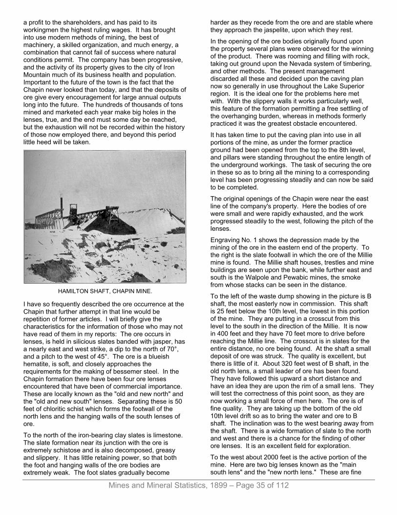
Mines and Mineral Statistics, 1899 – Page 35 of 112
a profit to the shareholders, and has paid to its workingmen the highest ruling wages. It has brought into use modern methods of mining, the best of machinery, a skilled organization, and much energy, a combination that cannot fail of success where natural conditions permit. The company has been progressive, and the activity of its property gives to the city of Iron Mountain much of its business health and population. Important to the future of the town is the fact that the Chapin never looked than today, and that the deposits of ore give every encouragement for large annual outputs long into the future. The hundreds of thousands of tons mined and marketed each year make big holes in the lenses, true, and the end must some day be reached, but the exhaustion will not be recorded within the history of those now employed there, and beyond this period little heed will be taken.
HAMILTON SHAFT, CHAPIN MINE.
I have so frequently described the ore occurrence at the Chapin that further attempt in that line would be repetition of former articles. I will briefly give the characteristics for the information of those who may not have read of them in my reports: The ore occurs in lenses, is held in silicious slates banded with jasper, has a nearly east and west strike, a dip to the north of 70°, and a pitch to the west of 45°. The ore is a blueish hematite, is soft, and closely approaches the requirements for the making of bessemer steel. In the Chapin formation there have been four ore lenses encountered that have been of commercial importance. These are locally known as the "old and new north" and the "old and new south" lenses. Separating these is 50 feet of chloritic schist which forms the footwall of the north lens and the hanging walls of the south lenses of ore.
To the north of the iron-bearing clay slates is limestone. The slate formation near its junction with the ore is extremely schistose and is also decomposed, greasy and slippery. It has little retaining power, so that both the foot and hanging walls of the ore bodies are extremely weak. The foot slates gradually become
harder as they recede from the ore and are stable where they approach the jaspelite, upon which they rest.
In the opening of the ore bodies originally found upon the property several plans were observed for the winning of the product. There was rooming and filling with rock, taking out ground upon the Nevada system of timbering, and other methods. The present management discarded all these and decided upon the caving plan now so generally in use throughout the Lake Superior region. It is the ideal one for the problems here met with. With the slippery walls it works particularly well, this feature of the formation permitting a free settling of the overhanging burden, whereas in methods formerly practiced it was the greatest obstacle encountered.
It has taken time to put the caving plan into use in all portions of the mine, as under the former practice ground had been opened from the top to the 8th level, and pillars were standing throughout the entire length of the underground workings. The task of securing the ore in these so as to bring all the mining to a corresponding level has been progressing steadily and can now be said to be completed.
The original openings of the Chapin were near the east line of the company's property. Here the bodies of ore were small and were rapidly exhausted, and the work progressed steadily to the west, following the pitch of the lenses.
Engraving No. 1 shows the depression made by the mining of the ore in the eastern end of the property. To the right is the slate footwall in which the ore of the Millie mine is found. The Millie shaft houses, trestles and mine buildings are seen upon the bank, while further east and south is the Walpole and Pewabic mines, the smoke from whose stacks can be seen in the distance.
To the left of the waste dump showing in the picture is B shaft, the most easterly now in commission. This shaft is 25 feet below the 10th level, the lowest in this portion of the mine. They are putting in a crosscut from this level to the south in the direction of the Millie. It is now in 400 feet and they have 70 feet more to drive before reaching the Millie line. The crosscut is in slates for the entire distance, no ore being found. At the shaft a small deposit of ore was struck. The quality is excellent, but there is little of it. About 320 feet west of B shaft, in the old north lens, a small leader of ore has been found. They have followed this upward a short distance and have an idea they are upon the rim of a small lens. They will test the correctness of this point soon, as they are now working a small force of men here. The ore is of fine quality. They are taking up the bottom of the old 10th level drift so as to bring the water and ore to B shaft. The inclination was to the west bearing away from the shaft. There is a wide formation of slate to the north and west and there is a chance for the finding of other ore lenses. It is an excellent field for exploration.
To the west about 2000 feet is the active portion of the mine. Here are two big lenses known as the "main south lens" and the "new north lens." These are fine

Mines and Mineral Statistics, 1899 – Page 36 of 112
bodies of ore, possessing great length and substantial width—from 60 to 100 feet. The new north lens was discovered by the present management and lies fifty feet north of the south lens. They are doing considerable opening upon this and are now down to the 9th level.
In the south lens they are taking the pillars, caving the surface and are now nearly down to the 7th. In slicing the pillars they are going through the tops of the old rooms just over the 7th level, observing this plan so as to have the drift in ore. They have mills about 38 feet apart, and the ore goes down nicely through these two-compartment channels. The ore is all sent to the 10th level, where it is taken to the Hamilton shaft, located at the northwest end of the property. Transfers are occasionally made at the most convenient points.
In engraving No. 2 is seen D shaft upon the left of the depression made by the settling ground. The view is taken looking to the west. It will be seen that the highway crossing the depression just east of the shaft has been blocked up with timber and upon this earth has been placed. The settling here is steadily going on and this despite the fact that an immense pillar of ore has been left in front of the shaft. This pillar is now being taken, however, and only that portion of it extending west of the shaft is still intact. At D shaft was located the magnificent steeple-compound pumping engine. This engine has been dismantled and now lies piled upon the dock ready to be disposed of as best they can. It is a fine engine, showed excellent economic results and would prove valuable to some concern if it could be permanently located. The settling of ground through which the shaft penetrated prevented the use of the pump here. Great cracks appear in the walls of the engine house located just beside the pumping station and shaft house and a portion of the stone walls had to be removed and repaired with lumber sheathing. There is a fine reel hoist here that works satisfactorily. The pillar retaining the shaft contains an immense amount of ore and will prove valuable in the product of the mine for several year to come. It will be possible to keep D shaft open for some time as it is only the upper portion that will be drawn out of line by the sliding of the foot-wall. This shaft goes through slates into jasper, the latter formation being strong and substantial and will not be affected by the removing of the ore in front of the shaft. It is desired to keep the shaft open as long as possible as through it they will handle timber. A hoisting plant is being removed from the old E open pit to this point. It consists of hoisting engine and a pair of 4-foot drums. It will be located south of the shaft upon solid ground.
D shaft is no longer used for the hoisting of ore, nearly all the product of the mine going to the Hamilton shaft, which is located in the limestone 1,174 feet to the northwest. To this point the ore from the main south and north lenses is taken by chain haulage. I described this system in my last report, it having been installed at that time. It has given perfect satisfaction, showing a considerably higher efficiency than the former rope haulage plant. With one rope they handled 360,000 tons
of ore from the mills to the shaft last season. The original cost of the chain is less than that of the rope such as was previously used, and there is much less delay in case of breakage. There is much time lost in the splicing of a wire rope whereas in the case of a broken chain they have split links all ready which can be inserted in a moment.
In the south lens they are to the 12th level, this point being reached by a winze sunk from the 11th. There has been no mining done below the 10th. The 11th was opened by drifts, and ore was found in encouraging quantity. A crosscut from the bottom of the winze proves the 12th will be of satisfactory dimensions. This portion of the mine is full of water below the 10th level.
To the east of D shaft is the Timber shaft, which secures its name from the fact that it is used for the handling of timber used in the mine. It is sunk upon the junction of the slates and jasper, and is to the 8th level. Due to the "drawing" of the top of the shaft by the moving foot an inclined shaft, intersecting it at a depth of 80 feet from surface has been put in from the south through the jasper. All shafts at the mine are vertical.
The Hamilton shaft is to a depth of 1,460 feet. Five levels in ore were opened by the Hamilton company prior to the purchase of the property by the Chapin Mining company. It is a fine shaft and equipped with a reel hoist which works to perfection. It was designed for the lifting of 10-ton skips to be operated in balance, but the load is five tons, this being handled with great speed and smoothness.
This shaft is connected with the Chapin lenses at the 10th and 12th levels. Other crosscuts diverging from the shaft, so that when they strike the ore they will be 600 feet apart, will be put in at the 12th level. The water in the western end of the mine is handled by the big Reidler pump located at the Hamilton shaft. While there has been no trouble caring for the water, 1700 gallons per minute, by slowly working the pump here and at the timber shaft, where a second Reidler pumping engine is stationed, there is some apprehension that there may be need of a more rapid operation of the engines at some time in the future. At the 10th level a strong inflow of water was met with. Several holes were drilled into the breast into which pipes were put and valves attached. These were opened as fast as the big pump could take care of the water. The water was also encountered upon the 12th level at a point a little further east. The draining of the water through the pipes on the 10th level revealed a vug that had a diameter of about eight feet, and of circular form. This was smoothed up for a depth of about 18 feet, and solidly filled with concrete. A 10-inch wrought iron pipe was carried through the dam, and a heavy flange was securely bolted to the end. This has securely shut off the water from coming into the level. When first struck on this level the water had a pressure of 276 pounds per square inch. The pressure shows that the water has a source only 103 feet below the collar of shaft. The shaft at the 10th level is 765 feet from surface. Just how large the source of supply is

Mines and Mineral Statistics, 1899 – Page 37 of 112
remains to be seen. The water evidently makes its way through the limestone which is everywhere prolific of water in this section.
The present owners have done nothing in the way of mining upon the Hamilton property, they desiring to first work down the Chapin ore bodies to a level corresponding with those of the Hamilton. This will require several years to accomplish. They have been mining upon the Ludington property, which they also possess, it being included in the transfer of the Hamilton. The Ludington embraces the south half of the southeast quarter and the northeast quarter of the southwest quarter of Section 25. The Hamilton embraces the north half of the southwest quarter of Section 30.
The company has been giving attention to the taking of ore from the Ludington lens, the latter extending upon Chapin fee. They reached this by going in the Ludington B shaft, which is to the 14th level, and is the only shaft now open on the old Ludington property. It is in the footwall of the ore formation. Its shaft house can be seen in engraving No. 2, being upon the left and just south of the open pit in the distance. While some ore is being taken from the old workings of the Ludington side of the line the most of it is being secured from the Chapin side. They have carried the work to a point between the 5th and 6th levels, everything above being practically removed. On the 5th, 6th and 7th levels they have put in drifts in the footwall which permits of bringing the ore down satisfactorily and giving them a safe avenue. On the 5th considerable jasper was met with near the hanging side of the deposit, and the length of the ore on this level was only 300 feet, due to the westerly pitch. Considerable jasper is also found on the 6th level. On the 7th is an old crosscut and a diamond drill hole. The latter is said to have found ore, but this is not definitely known to the company as the former owners plugged it up to stop the flow of water which came through it. They did not follow it to the ore, if ore was struck in the hole. They have raises through to the 10th level and are connected with the 10th level Hamilton. A drill hole taps the 11th Hamilton and a small drift is put in at the 14th. The old maps of the Ludington show a large body of ore at the 11th, 12th, 13th and 14th levels, the latter being 1296 feet from surface. There are favorable indications of a great increase in the dimensions of the ore body at greater depth, and no property in the Lake Superior region shows more persistency in this direction. The ore lenses here give evidence of being deeper seated than those of most iron mines in this district. The Ludington and Hamilton portion of the property promises substantial additions to present ore developed areas when a sufficient depth has been reached. The merging of the north and south veins is not improbable. Should it so result it would give a fine opportunity for big products.
There has been no change in the manner of winning the ore of the main Chapin deposits. Levels are carried 100 feet thick, and these are divided by three sub-levels. In case they are found advantageous intermediate levels
are opened between the "subs." Drifts are put through the center of the ore body, the ore cut into blocks from foot to hanging and then sliced back towards the main drift and raises. The ore conies readily and the overlying "gob" follows closely, making safe work for the miners. Original cuts generally show firm ground needing the power drill and plenty of high explosives to make proper headway in, but after the opening is made the ground rapidly loosens and slabs off from the side of the drift. There is a heavy lateral pressure throughout the mine, as often described in my reports and once this has an opening to exert itself in the mining is easy and much of the ore is secured without the use of explosives or power drills. The timber employed is generally of small size such as is used in the drift sets of the caving method of extracting the ore. Nearly all the mining is done upon the contract plan, the price being based upon the ton of ore broken or the number of feet of sinking or drifting.
The Chapin has a very neat arrangement for the stocking of its ore. Engraving No. 3 shows the end of the stockpiles. The first pile shows the work of stocking has been completed, the tracks having been removed from the top and the end blocked up with lagging. The second pile is nearing the end while the third trestle shows no ore. The cars are handled from the Hamilton shaft by a rope-haulage plant located just north of the engine house. The rope is carried the length of the stockpile trestle, running around a pully fixed at the end of the trestle. The cars used hold five tons each and the ore is released from both sides simultaneously by the tripping of the latch holding the wings in position, this being done by a lever on the car coming in contact with a piece of plank, iron topped, which is securely bolted to the trestle so as to engage the car lever. These "trippers" are of different heights so as to come in contact with the releasing lever of the car, the lever being set by the man at the shaft so the ore will be discharged at the desired place on the trestle. The center of the car is built up like an inverted "V" so that when the wings are released the ore readily slides down the inclined plane formed by the car bottom. The ore of the mine is dry and runs out rapidly. The lever is returned to place again as the car moves back to the shaft and the wings come into position by their own weight. The engraving shows a car with the wings extended and the ore escaping. It is a rapid and economical way of putting the ore in stock. One man at the shaft house attends to the work of setting the levers at the desired point, one is needed to operate the haulage engine and that is all the labor required.
When the piles are finished the tracks and top timbers are removed and the steam shovel pulls out the legs as the stockpile is loaded. The loss of timber due to breakage in removing was only 1% last year. I believe where there is room to arrange for this plan of stocking that it is one of the best practiced. The skips in the Hamilton shaft are attached to the cages, as described in my last report. They work finely.

Mines and Mineral Statistics, 1899 – Page 38 of 112
The Chapin has a great advantage over other mines in this field in the cheapness of its power. Air is supplied from a hydraulic station located three miles distant upon a falls in the Michigamme river. There are four large compressors here and compressed air is provided the mine through a large iron main. A pressure of 65 pounds to the square inch is developed at the hydraulic station which gives 60 pounds at the mine. The past year a new turbine wheel was put in and differs from the old in that it has a horizontal bearing whereas the old one was vertical. The improvement is shown by an increase of from 8 to 10 revolutions per minute, and more power is developed in consequence. The turbine is now above the floor level whereas it used to be below the floor line. The air compressed here gives nearly all the power needed for operating all the machinery, power drills, etc., of the mine.
The company is well provided with shops for the building of new work and repair of old. It has a fine sawmill where timber is cut into desired shapes and everything about the property is well kept. The No. 1 engine house of the Ludington mine, a substantial structure, has been converted into a change house. It makes a model one, and is well supplied with conveniences for the employes. The building can be seen in the engraving and is located just east of the Ludington stockpile.
For 1898 the Chapin sent out 724,768 tons of ore. The preceeding year its output was 642,347 tons, and for all years it has contributed to the total of Lake Superior mines 7,500,758 tons. The Hamilton, before it was purchased by the Chapin, 96,072 tons, and the Ludington 1,001,518 tons. The Chapin lenses give two grades of ore, the “Chapin,” containing 61.60% iron and .064% phosphorus, and Rex, giving 57.54% iron and .066% phosphorus. The Ludington gives their “Star” grade, holding 62.29% iron and .085% phosphorus. The company is now employing about 900 men.
The Chapin is a magnificent property, and is admirably handled. It has a wide-awake, progressive management and a bright future. The local officers are: James MacNaughton, general manager; L. B. Sutton, who has been assistant to Mr MacNaughton for several years has resigned to take a position with the Minnesota Iron company; Martin Goldsworthy is mining captain; M. Lonergan, cashier. The principal offices are in Cleveland, Ohio. M. A. Hanna is president of the company; L. C. Hanna, vice president; A. M. Robbins, secretary.
THE PEWABIC MINE, The Pewabic mine is second in labor-employing importance in the city of Iron Mountain, as it is in the amount of ore sent to market. It is conducted by an enterprising management and one that has contributed much for the good of the local surroundings as well as for the Menominee range in general. In its time of activity the mine has produced 1,800,767 tons of ore. Its
shipment for 1898 was 305,072 tons and for 1897 it was 279,095 tons.
The lands holding the mine are described as the southwest quarter of the northwest quarter of Section 32, Town 40, Range 30, and the mine location is upon the top of a hill many hundred feet upon the surrounding country. The company is fortunate in the ownership of half of the fee of the lands from which its mineral is obtained, and it is closely associated with the Carnegie company, the greatest maker of steel in the world. This insures a steady operation of the mine, and is valuable to the people who surround it. The strike of the ore is a little south of east and north of west. The dip is variable, being 80° to the south in the west end of the mine and in the east end of the mine it runs from 70° to 45° to the north. The pitch is to the west.
There are two shafts, No. 1 located 550 feet east of the west line of Section 32, and No. 2 located 1200 feet east of No. 1. The western shaft is to the 5th level and the eastern is now to the 6th, the latter having been recently added. No. 2 has for some time been the principal working shaft. It is four-compartment, is 21’x6’. One of the compartments has been divided so it gives place for two timber cages. Besides this there are two cage-ways and a pump-way. Power to do the hoisting at this station is furnished by two ten-foot drums and 24x48-inch direct acting engines.
In its earlier history the Pewabic was noted for its high grade ore, well known in the market as "Pewabic." It was wonderfully pure, shipping at 66% iron and .007% phosphorus. As depth was attained in the mine this high-class ore gradually gave way to that of poorer quality, and jasper came in abundantly, this interfering with the easy mining of the higher areas. Water in large volume was also encountered in the lower workings and sinking was for some time deferred until a pumping plant of adequate capacity to meet the requirements could be provided. The pump is now in, is stationed at the 6th level, and is a fine one. It is a triple-expansion Worthington, which I have before described in my reports of the mine.
The 6th level, the last to which No. 2 has been sunk, is 800 feet from surface, and here the company hopes to discover something in the higher grade of ore which will give them an additional lease of life. If the lens of the level above follows downward to this point there is a chance for its making into something valuable. The shaft has been sunk with this object in view.
They have pushed a drift in 200 feet east of the shaft, and at 50 feet from the shaft are driving a crosscut. At 300 feet from the shaft in the main drift they will crosscut the formation again and hope to find the ore body.
The management does not look for important lenses of ore aside from the one which has followed down in the mine. They have explored the surrounding ground systematically and thoroughly with drifts and diamond drill borings and found nothing of value of Pewabic grade. The 6th level is therefore being opened with
Mines and Mineral Statistics, 1899 – Page 39 of 112
considerable anxiety on the part of the operators its revelations will mean much to future production.
The principal mining done for the past two years has been ion the third level and about 300 feet west of No. 2 shaft here there is a large body of ore of silicious grade, styled “Genoa." This gives 44% iron and .007% phosphorus, and is very uniform in these elements. It is popular in the market and sales can be had this season for all that can be mined. I have before described the plan of mining this ore. It is to take rooms of 70 feet and afterward undercutting the pillars, letting the whole mass come down, which it does gradually, self-crushing the ore to the desired fineness. The settling plan works finely, and they follow over the same cut many times, the ore coming just right to permit of this. They have about 800,000 tons of this ore now undercut and ready to attack. They can mine 350,000 tons of it this year if nothing interfers with continuous operation.
The Pewabic grade now obtained is secured principally from pillars between the 3rd and 4th levels. They are also mining a "Toledo" grade, giving 55% iron and .007% phosphorus. Tihs comes from between the 3rd and 4th and some of it is obtained in the area from which the Genoa grade is being taken. A little non-bessemer is being obtained from the extreme eastern end of the mine. This gives 62% iron and .100% phosphorus. In the main workings everything above the second level has been taken and the second has been worked out to 50 feet above the 3rd level. The work of taking pillars in the older portion of the mine is now practically finished. On the better grades of ore below this point they are working upon the sub-level plan, taking blocks of ground twenty feet thick, and this plan has been observed to some extent in the taking of pillars. They have varied the style to the conditions met with.
There is a vast amount of the Genoa grade ore in the mine, enough to keep the property busy for many years to come. It has been a great help to the company the past two years. Five years ago the ore could not be disposed of at any figure. It is probably due to the need of such a mixture for the Mesaba range ore that the demand has been so keen for ores of this class. Being so low in phosphorus and so rich in silica, Genoa is valuable as a mixture for the ores of the Mesaba district, which are of a very fine-grained structure.
There has been some apprehension concerning the water in the lower workings of the mine. They have constructed to keep it out, have the big new pump referred to, and besides this they have a plant of Cameron pumps, serving as a relief system in case of accident to the Worthington or an unusual rush of water into the mine. The proximity of the limestone! gives some cause for uneasiness, as it is the source of the excessive water flows met with upon the Menominee range.
THE WALPOLE MINE. The work of exploring the Walpole property, which lies immediately north and west of the Pewabic, and is now in the possession of the Pewabic company, is still in progress. At the 3rd level of the Walpole shaft and 403 feet from surface, they have a body of non-bessemer ore 500 feet long, varying from 5 to 50 feet wide, and having an average width of 20 feet. Above the 3rd level they have mined the most of the ore out. The shaft will be sunk 100 feet deeper. A winze has been put down in ore 100 feet preparatory to sinking the shaft another lift. Up to within a short time this ground has been very dry, but in late sinking water has been met with and boiler and pump has been brought into use to take care of it. The ore below the 3rd level looks promising for an increase of dimensions. It gives 60% in iron and .085% phosphorus, with a very low moisture. Previous to this time it has held moisture at the rate of 40%, and later has given 7%. The grade of ore is known as “Tyron.”
There is a crosscut being put in from the 1st level of Walpole shaft, 250 feet from surface, and directed towards No. 1 shaft Pewabic mine. It is now in about 1250 feet. It is expected to strike the 300-foot level of the Pewabic mine, ground rising gradually from, the Walpole shaft going which accounts for the discrepancy in depth from surface of drift at the Walpole and Pewabic shafts.
There is a chance for ore of better grade in the territory lying between the Pewabic and Walpole shafts, and it is with idea of locating such a body that the crosscut is being put through.
The concentrating mill of the Pewabic company is operated only in the summer months, or during the time when water will not freeze. The ore treated by the mill is taken from the northeast quarter of the southeast quarter of Section 32, Town 40, Range 30, the mill being located upon the property. The mill produced 5,000 tons of ore of Pewabic grade last year. There were many stoppages due to changes made in the plant which were required by the conditions met with. Several revolving screens were put in last year, and more will be added the coming spring. It is figured that 15,000 tons of Pewabic grade will be obtained from 45,000 tons of mineral during the the summer of 1899. The ore as it comes form the mine is crushed and then pressed between steel rolls. The crusher is of Blake pattern with 14”x24” opening. Rolls are 14”x24”. The material passes over shaking tables and revolving screens, being automatically handled from mine to storage bins. From the mouth of the adit from which the ore is taken there is plenty of fall for the automatic carrying of the ore from one stage of dressing to the final process. Professor Louis M. Heidenberg has charge of the works.
During the past fall and winter they have been developing the ore-bearing stratum from which the material for treating in the concentrator is obtained. This lies upon a side hill, and is reached by a drift driven into the hill from a point just above the top of the mill. The
Mines and Mineral Statistics, 1899 – Page 40 of 112
ore has a sandstone capping and rests upon limestone. In the course of developing work the past winter they have found places where there are depressions in the limestone and here the ore has a thickness of over fifty feet. The estimated thickness of the stratum has been figured in the past at thirty feet, but these additions will give it greater depth than at first thought. They are opening the ore-bearing formation for a width of eighty feet by crosscuts from the main drift. The drift will be carried to the extreme limits of the strike of the ore, and this point reached they will beat out the ground back towards the mouth of the adit.
The material secured for the mill thus far has come from preparatory openings. There is a large amount of ore here and the mill can be kept busy for many years. The ore secured is of the finest quality and sells for the highest price. This is the only ore concentrating works now being operated in the Lake Superior iron mining region. Other attempts have been made but all have proven failures.
The Pewabic company is employing about 350 men, nearly all of whom are worked upon the company-account plan, it being one of the few companies in the district observing it.
The company owns mineral lands on the range and has done considerable exploring upon them. At present all explorations have ceased. The Keel Ridge property, upon which the Commonwealth Iron company is operating, and located on Sections. 28 and 32, close to Pewabic mine, is owned by Pewabic. It contains silicious ores giving about 40% iron.
E. F. Brown is general manager; James Holland, mining captain; W. G. Monroe, cashier; E. E. Brewster, chemist; Geo. D. Van Dyke, Milwaukee, president.
THE MILLIE MINE. This property lies between the Chapin and Walpole mines. It is in the footwall of the Chapin mine formation, and the ore now obtained is upon Chapin territory, the company paying a royalty to the Chapin people for the ore extracted. The property produced 17,450 tons of ore in 1898, and is working only a small force at present, following the ore and hoping it may make into something larger. There are no signs of a widening of the deposit at this time. The lenses are small, the surrounding formation being close and compact with but little room for ore to make. They added the 8th level the past year. A force of eighteen men is engaged. Chas. McGregor is superintendent, S. Dessau, New York, president. The company operates under the title of the Dessau Mining company.
THE ANTOINE ORE COMPANY. This company mined 104,510 tons of ore from its pits last| year. The ore secured gives about 43% iron, .025% phosphorus.
There are three pits, locally known as the Clifford, and Cornell. The work the past two years has been the hands of Ogelbay Norton & Co., of Cleveland, Ohio, with O C. Davidson, of Commonwealth, Wis., as general manager, and F. L. Coventry, Iron Mountain, as superintendent.
There have been some changes made since last season. The pits are worked only during the summer months. Heretofore the ore has been broken from the sides of the pit, trammed to raises and sent to the level below where there was an extra handling of the material to get in to the shaft. They have changed this so the ore goes direct through chutes to the cars at the bottom of the level, saving much time as compared with the old style. During the winter they extended their shaft 100 feet so that now they have a fine chance to break ore. This is at the Clifford pit on the northeast quarter of the northwest quarter of Section 20, Town 40, Range 30. They have a crushing plant here, a Gates, which does its work well. The ore is of a flaggy nature and breaks readily. There is a large deposit of it, and while the price received for it is low the company can, by the exercise of the closest economy, manage to make a very small profit.
The same company is also working the Keel Ridge property just beside the Pewabic mine. They have a shaft down fifty feet in the footwall. The ore dips north but as they go down upon it there is a change to a nearly vertical position. The ore is soft, and may not need crushing. It is also inclined to run, and there is a chance for the finding of a better grade than is showing near surface. They hope to secure 150,000 tons from this pit this season. It is owned by the Pewabic company to whom they pay a royalty of five cents per ton for the ore mined.
THE PROTECTION MINE, Located upon the southeast quarter of Section 22, Town 40, Range 30, has been idle since my last report. They have a silicious ore which gives about 40% iron, and is of bessemer grade. It is owned by Welcome Hyde, of Appleton.
The property has just been secured by the American Wire & Steel company, who will proceed at once to develop it, under direction of their representative, Jos. Sellwood.
THE ARAGON MINE. With the sinking of a new shaft, the putting in of new machinery and the loss of one of its old shafts, the Commonwealth Iron company, for the year 1898, shipped from its Aragon mine, located at Norway, 295,821 tons of ore, this exceeding! any former achievement for a similar period in the history of the property. Its product for 1897 was 144,760 tons, and the total amount sent out to date is 1,298,927 tons.

Mines and Mineral Statistics, 1899 – Page 41 of 112
The company took charge of the property in July of 1897, finding it badly in need of equipment with which to work economically, the former owners having allowed the local management nothing for the installing of modern plants. Since the time of securing possession of the mine the company has been energetically trying to get it into proper condition for the sending out of a sufficient tonnage to warrant a profit being secured to its shareholders. There was a vast amount of work to be done, and it has really been more difficult than if a new mine were started from grass roots. With the transformation in machinery also came one in the method of winning the ore, and changes of this kind are accompanied by considerable trouble as well as expense.
Formerly the Aragon roomed the ore and afterward filled the rooms with sand, this in turn being followed by the securing of the pillars. There was an immense bank of sand close to the shafts and the sand was milled into the mine to be distributed in the worked-out portions as it best could be. The sand packed well, and pillars taken were little mixed with it. The sand took considerable moisture in going into the mine, which was a wet one, and there was considerable pressure upon it after it found its way to the rooms, the result being to give it considerable firmness.
There were two shafts, No. 2, located at the east end of the mine and No. 3 at the west. These were 700 feet apart, and were to the 8th level, 750 feet below surface. No. 3 was in the ore measure, and there was constant settling of the ground about it. To this was added a lateral squeezing, and finally, in October, 1898, the shaft had to be abandoned. This has interfered considerably with the mining, as all the ore sent to surface has to go through No. 2, at the eastern end of the property, and 2,000 feet distant from the extreme western workings. No. 3 shaft is still kept open for ventilation, but its entire closure is but a question of a short time.
No. 4 shaft is sinking, and connection was made about May 10th, 1899, with the 8th level. This was described in my last report as the “Harrison” shaft. Its location is 700 feet south of the No. 3 shaft. It is vertical, 6’x13’ inside timbers, and its upper portion is in the slates of the hanging wall of the “south ore formation.” There are two ore formations here, as in many of the mines of the Menominee range. It enters the ore formation on its downward course. It was originally started by the Penn Iron company, who sunk it 200 feet. A large flow of water was encountered which was successfully dammed back and it is this fact which decided the present operators to hold to the present dimensions of the shaft, fearing the water would give them much trouble in case they decided to enlarge the opening and cut out the old dam. This shaft is now down 530 feet and a drift from the 8th level of the mine, 750 feet from surface, has been extended to the downward line of the shaft and connnected with the latter.
With the No. 4 shaft in commission the Aragon will be well prepared to send to surface all the ore that can be
mined, and this time will have been reached the coming summer. With this additional avenue provided the company will be able to ship 400,000 tons of ore this year, and they are arranging for an output of this size.
The running of sand into the mine was stopped in June, since which time they have been settling the ground, permitting the overlying burden of rock and earth to come down as the ore is removed. Thus far it has been attended with satisfactory results. There has been times when the sand has been carried down by the surface water and care had to be taken to prevent a too free mixture of this material with the ore. The sand, it will be remembered, has been run into the worked-out portions of the mine for many years past, and in the system recently inaugurated portions of the old filling is carried down by the water. The Aragon has always been a very wet mine, about 15,000 gallons per minute having to be handled by the pumps, and this may cause a little trouble with the caving plan until a few slices have been taken off and the "gob" prevents the sand from coming through. The ore is soft and all the ground has to be timbered while they are cutting through it. Gradually the sand will be cut off and then no further trouble will be experienced from that quarter. The plan observed in mining the ore will be similar to that practiced at the Pewabic mine, at Iron Mountain.
In some of the pillars on the 7th level, which are now being taken, the sand can be seen standing to a height of ten feet. The 6½ level is now almost cleaned of its ore. There is considerable ore on the 7th and this will furnish a considerable portion of the output of the present season. The west end of the level has been nearly all worked out, but there are fine stopes in the east end of the mine. They have started on the 7½ level and are getting ready to begin caving. They would start the caving on the 8th level but for the fact that the ore at the extreme east end of the mine is very flat and it could not be brought down. There is evidence that there will be a straightening up of the walls at greater depth, however, when full levels can be brought down. From the 8th down they will take sub-levels of 25 feet, carrying main levels 100 feet thick. On the 7¼ level the ore is small and bunchy, running from 10 to 30 feet wide and is only 150 feet long.
It is upon the 8th level where the greatest gain in ore bodies has been made and a wonderful increase is noticeable since the time of our last report of the mine. Besides their main lens of ore upon this level they have followed the "stringer" of ore which showed upon higher levels and which was narrow, about the thickness of the drift. On the 8th it has widened out finely and for several hundred feet they have followed it, the end of the ore as thus far explored showing a thickness of forty feet, with ore still in the breast of the drift. As they have followed it the ore has taken a decided turn in a northwesterly direction as it approaches Nelson street of the village, but it will probably change to its former course, nearly west.
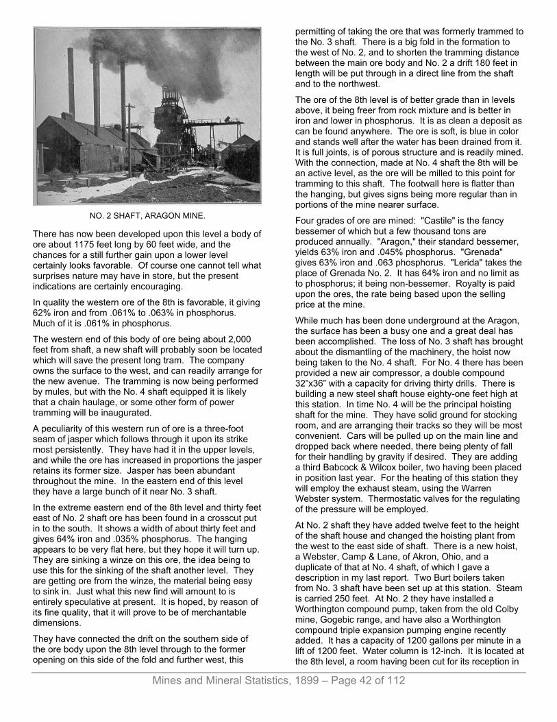
Mines and Mineral Statistics, 1899 – Page 42 of 112
NO. 2 SHAFT, ARAGON MINE.
There has now been developed upon this level a body of ore about 1175 feet long by 60 feet wide, and the chances for a still further gain upon a lower level certainly looks favorable. Of course one cannot tell what surprises nature may have in store, but the present indications are certainly encouraging.
In quality the western ore of the 8th is favorable, it giving 62% iron and from .061% to .063% in phosphorus. Much of it is .061% in phosphorus.
The western end of this body of ore being about 2,000 feet from shaft, a new shaft will probably soon be located which will save the present long tram. The company owns the surface to the west, and can readily arrange for the new avenue. The tramming is now being performed by mules, but with the No. 4 shaft equipped it is likely that a chain haulage, or some other form of power tramming will be inaugurated.
A peculiarity of this western run of ore is a three-foot seam of jasper which follows through it upon its strike most persistently. They have had it in the upper levels, and while the ore has increased in proportions the jasper retains its former size. Jasper has been abundant throughout the mine. In the eastern end of this level they have a large bunch of it near No. 3 shaft.
In the extreme eastern end of the 8th level and thirty feet east of No. 2 shaft ore has been found in a crosscut put in to the south. It shows a width of about thirty feet and gives 64% iron and .035% phosphorus. The hanging appears to be very flat here, but they hope it will turn up. They are sinking a winze on this ore, the idea being to use this for the sinking of the shaft another level. They are getting ore from the winze, the material being easy to sink in. Just what this new find will amount to is entirely speculative at present. It is hoped, by reason of its fine quality, that it will prove to be of merchantable dimensions.
They have connected the drift on the southern side of the ore body upon the 8th level through to the former opening on this side of the fold and further west, this
permitting of taking the ore that was formerly trammed to the No. 3 shaft. There is a big fold in the formation to the west of No. 2, and to shorten the tramming distance between the main ore body and No. 2 a drift 180 feet in length will be put through in a direct line from the shaft and to the northwest.
The ore of the 8th level is of better grade than in levels above, it being freer from rock mixture and is better in iron and lower in phosphorus. It is as clean a deposit as can be found anywhere. The ore is soft, is blue in color and stands well after the water has been drained from it. It is full joints, is of porous structure and is readily mined. With the connection, made at No. 4 shaft the 8th will be an active level, as the ore will be milled to this point for tramming to this shaft. The footwall here is flatter than the hanging, but gives signs being more regular than in portions of the mine nearer surface.
Four grades of ore are mined: "Castile" is the fancy bessemer of which but a few thousand tons are produced annually. "Aragon," their standard bessemer, yields 63% iron and .045% phosphorus. "Grenada" gives 63% iron and .063 phosphorus. "Lerida" takes the place of Grenada No. 2. It has 64% iron and no limit as to phosphorus; it being non-bessemer. Royalty is paid upon the ores, the rate being based upon the selling price at the mine.
While much has been done underground at the Aragon, the surface has been a busy one and a great deal has been accomplished. The loss of No. 3 shaft has brought about the dismantling of the machinery, the hoist now being taken to the No. 4 shaft. For No. 4 there has been provided a new air compressor, a double compound 32”x36” with a capacity for driving thirty drills. There is building a new steel shaft house eighty-one feet high at this station. In time No. 4 will be the principal hoisting shaft for the mine. They have solid ground for stocking room, and are arranging their tracks so they will be most convenient. Cars will be pulled up on the main line and dropped back where needed, there being plenty of fall for their handling by gravity if desired. They are adding a third Babcock & Wilcox boiler, two having been placed in position last year. For the heating of this station they will employ the exhaust steam, using the Warren Webster system. Thermostatic valves for the regulating of the pressure will be employed.
At No. 2 shaft they have added twelve feet to the height of the shaft house and changed the hoisting plant from the west to the east side of shaft. There is a new hoist, a Webster, Camp & Lane, of Akron, Ohio, and a duplicate of that at No. 4 shaft, of which I gave a description in my last report. Two Burt boilers taken from No. 3 shaft have been set up at this station. Steam is carried 250 feet. At No. 2 they have installed a Worthington compound pump, taken from the old Colby mine, Gogebic range, and have also a Worthington compound triple expansion pumping engine recently added. It has a capacity of 1200 gallons per minute in a lift of 1200 feet. Water column is 12-inch. It is located at the 8th level, a room having been cut for its reception in
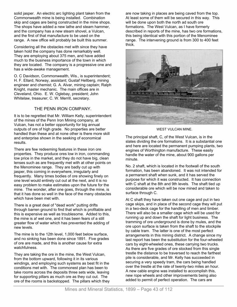
Mines and Mineral Statistics, 1899 – Page 43 of 112
solid jasper. An electric arc lighting plant taken from the Commonwealth mine is being installed. Combination skip and cages are being constructed in the mine shops. The shops have added a new lathe and steam hammer, and the company has a new steam shovel, a Vulcan, and the first of that manufacture to be used on the range. A new office will probably be built this summer.
Considering all the obstacles met with since they have taken hold the company has done remarkably well. They are employing about 375 men, and have added much to the business importance of the town in which they are located. The company is a progressive one and has a wide-awake management.
O. C Davidson, Commonwealth, Wis., is superintendent; H. F. Ellard, Norway, assistant; Gustaf Hellberg, mining engineer and chemist; G. A. Alvar, mining captain; Ralph Knight, master mechanic. The main offices are in Cleveland, Ohio. E. W. Oglebay, president; John Whitelaw, treasurer; C. W. Merrill, secretary.
THE PENN IRON COMPANY. It is to be regretted that Mr. William Kelly, superintendent of the mines of the Penn Iron Mining company, at Vulcan, has not a better opportunity for big annual outputs of ore of high grade. No properties are better handled than these and at none other is there more skill and enterprise shown in the seeking of economical results.
There are few redeeming features in these iron ore properties. They produce ores low in iron, commanding low price in the market, and they do not have big, clean lenses such as are frequently met with at other points on the Menominee range. They are badly cut up with jasper, this coming in everywhere, irregularly and frequently. Many times bodies of ore showing finely on one level would entirely cut out at the next, and it is no easy problem to make estimates upon the future for the mine. The wonder, after one goes, through the mine, is that it has done so well in the face of the many obstacles which have been met with.
There is a great deal of "dead work" putting drifts through barren ground to find that which is profitable and this is expensive as well as troublesome. Added to this, the mine is a! wet one, and it has been fears of a still greater flow of water which has prevented the adding of new levels.
The mine is to the 12th level, 1,000 feet below surface, and no sinking has been done since 1891. Five grades of ore are made, and this is another cause for extra watchfulness.
They are taking the ore in the mine, the West Vulcan, from the bottom upward, following it in its various windings, and employing such systems as best fit in the conditions met with. The commonest plan has been to take rooms across the deposits three sets wide, leaving for supporting pillars as much ore as they cut out. The ore of the rooms is backstopped. The pillars which they
are now taking in places are being caved from the top. At least some of them will be secured in this way. This will be done upon both the north ad south ore formations. The West Vulcan, as I have formerly described in reports of the mine, has two ore formations, this being identical with this portion of the Menominee range. The intervening ground is from 300 to 400 feet thick.
WEST VULCAN MINE.
The principal shaft, C, of the West Vulcan, is in the slates dividing the ore formations. It is a substantial one and here are located the permanent pumping plants, two engines of Worthington manufacture. These easily handle the water of the mine, about 900 gallons per minute.
No. 2 shaft, which is located in the footwall of the south formation, has been abandoned. It was not intended for a permanent shaft when sunk, and it has served the purpose for which it was constructed. It has connection with C shaft at the 8th and 9th levels. The shaft tied up considerable ore which will be now mined and taken to surface through C.
At C shaft they have taken out one cage and put in two cage skips, and in place of the second cage they will put in a two-deck cage for the handling of men and timber. There will also be a smaller cage which will be used for running up and down the shaft for light business. The tramming of ore underground is done by mules, and the ore upon surface is taken from the shaft to the stockpile by cable tram. The latter is one of the most perfect arrangements in this mining district. A change since my last report has been the substitution for the four-wheeled cars by eight-wheeled ones, these carrying two trucks. As there are five grades of ore stocked from this single trestle the distance to be traversed to reach the farthest pile is considerable, and Mr. Kelly has succeeded in securing a very speedy tram, the cars being handled over the trestle at the rate of twenty-two miles an hour. A new cable engine was installed to accomplish this, new rope wheels and other improvements being also added to permit of perfect operation. The cars are
Mines and Mineral Statistics, 1899 – Page 44 of 112
automatically dumped wherever it is desired to deliver the ore, this being caused by a system of levers and trips attached to the car and the trestle. A car can be seen in the accompanying engraving of C shaft.
With the cable tram on surface and the mules underground ore and material for filling the worked rooms is cheaply handled. They use for filling the waste rock from the old dumps upon surface, which is sent to the levels through the mills and trammed to points where it is needed. The filling plan has been a success here. They are working from the bottom to the 7th level. Above the 7th they have nothing of importance in the way of ore bodies.
The west end of the property has been most productive of ore of the best class secured here. Nearly all of the grades are satisfactory as to phosphorus, but they are low in iron, as will be seen by the analysis tables which appear at the end of the iron range descriptions. In the east end of the mine they have done considerable exploring during the past three years, but have only ore of inferior quality to show for it. The company possesses the fee of this end of the mine, and by reason of this fact are desirous of finding merchantable ore in this quarter. They secure their "Pluto” grade from this end of the property. It gives 50% iron and 50% phosphorus. They have found it in the 8th and 9th levels in this end of the mine.
The Penn company has the advantage of being interested in furnaces as well as in mines, and this has assisted in the marketing of all the grades produced. They also run stores for the accommodation of the men, and with these aids manage to keep the property in motion.
There is ore showing in the bottom of the mine, the 12th level possessing a promising quantity, but as they go down the flow of water increases. It is this fact which has caused the stoppage of deepening the shafts for so many years. Soon this work will have to be resumed, and the chances of meeting with more water than can be handled will have to be accepted. It appears that in this direction lies the future hope of the company for annual products.
One fourth of a mile east of the Vulcan mine the company has been conducting explorations for ore for some months past. They have a deposit of ore about eight feet thick and 35 feet long at the 50-foot level, and at a depth of 95 feet it has not grown in size. They are sinking a winze from the 95-foot, hoping the lens may increase at greater depth.
The East and Southeast Vulcans have just been secured under option by Pickands, Mather & Co., of Cleveland, Ohio, who will unwater them with a view to mining. Both properties have been idle since 1893. There were small chimneys of ore that lacked persistency from one level to another and there was considerable water. The lack of a suitable pumping plant was one of the reasons for the suspension of work at this point.
THE CURRY MINE. This possession of the Penn Iron Mining company was closed in June, 1897, and was permitted to fill with water. Orders for a resumption have been given and the mine is now being unwatered. The shaft will be repaired, it needing re-timbering in the upper levels, and there will be considerable ore mined this year, 1899.
The Curry is opened to the 8th level and is 800 feet deep. Its ore is principally non-bessemer. It possesses the two formations as does the West Vulcan, which is located immediately east, but while the West Vulcan's best stopes are found on the north vein, the latter has thus far proved barren in the Curry. They have done considerable exploring in the hope of finding lenses of value on this formation, but thus far without success.
THE NORWAY MINE. There was a time when the Norway mine of the Penn company was looked upon as one of the biggest and best in the district. There was a fine showing in the upper levels which changed to rock in the lower ones. They are working a few men here, taking the ore of low grade for which there is a market, and which comes from the upper portion of the old workings.
The mines of the company have produced, all told, 4,610,146 tons of ore.
The shipment for 1898 was 223,713 tons, 14,173 tons less than were shipped the previous season. The working force consists of 350 men.
William Kelly is general manager; F. C. Copeland, assistant; William Bond, mining captain.
THE LORETTO MINE. This is a producer of ore of high grade and much noted for the purity of the output. It is a small mine, and has sent to market since it began business 274,159 tons. For 1898 it sent out 68,447 tons.
The location of the mine is Section 7, Town 39, Range 28, and is one and one-half miles away from Loretto, a station upon the Chicago & Northwestern railway. The deposit lies at a point where the Sturgeon river and Pine creek meet, and the ore extends beneath the waters of these streams.
The original deposit here was one of bowl-shaped outlines, and extended downward only to the second level. From this the shipment for the first few years in the history of the mine was secured. More recently they found another lens of ore 200 feet south of the old mine, this being discovered by a crosscut put in from the second level of the old deposit, slates intervening. At the time of my last description they had crosscutted from the shaft to this new location at a depth of 160 feet, finding the ore. The shaft is 6x12 feet inside timbers. It has been extended for the third level, 125 feet below the second level the past winter.

Mines and Mineral Statistics, 1899 – Page 45 of 112
In the putting in of the drift to reach the south ore body on the third level they encountered another lens of ore fifty feet from the shaft which had not been met with in the previous working of the mine. This was a small lens seven feet wide by 35 feet long and was mined out to a height of 70 feet above the level. A winze was sunk from the bottom of the level and struck rock having an underlay which gives the lens the same angle of inclination to the east as is found in the south ore body, but a little flatter upon its dip, about 45 degrees. The winze has been sunk 75 feet from the bottom of the vertical on the angle of the formation and is now 80 feet vertically below the third level. It is the intention to sink it 30 feet more on the present angle and to push down the hoisting shaft to a corresponding level, 100 feet, and crosscut to the bottom of the winze in order to mine the ore. The latter is of fine quality, assaying 66% in iron and .020% phosphorus. As they have sunk upon it the ore has increased in size, and gives promise of turning into a deposit which will furnish a profit from its working.
The south ore body was struck at about the same distance from the shaft as in the second level, and shows a lens 40 feet wide, and a raise has been put up connecting with a shaft in the ore which is to the second level. This shaft will be used for the handling of timber and for ventilation.
Drifts are being put in east and west on the trend of the ore. To the west they are in 130 feet, and are in ore for this distance. The ore shown here is of their "Russell" grade. The east drift is in 280 feet, is under the Sturgeon river and is following the ore. There has been a change in the ore for the better in the end of the drift, it giving 60% iron and the phosphorus is decreasing. It is the intention to continue the drift to the opposite bank of the river and until a point opposite a shaft here in the slates has been reached, and then to sink a shaft to a level with the drift. This shaft is down 90 feet. It is in hard, dry slates, and it would need but a short crosscut to connect with the ore. This would insure a safe working of the deposit. With the river overhead the ore would have to be taken skillfully to prevent accident. They could leave pillars as they do at the Hemlock River mine, this range, and the shaft in the slates would permit of working the ore to the best advantage. The hoisting shaft is sunk in similar slates. It allows of rapid sinking and is permanent.
At the third level of the old shaft a large sump and pump room has been cut out and a fine new Prescott pump will be installed. It will be duplex with compound steam end and will have a capacity of 700 gallons per minute. Up to the present time the water does not exceed 350 gallons, but in view of the deepening of the mine and the proximity to the river it is deemed advisable to prepare for any extra flow which may come from the lower levels or from the streams.
A new dry having two floors with lockers for 200 men, with superintendent's office and dry for shift bosses has been recently erected. It is a comfortable building and well arranged. Six new dwelling houses have been built
and are occupied. There are from 160 to 170 miners and laborers being employed.
The main offices of the Loretto Iron company are in Chicago. D. F. Bremner is president; Harold V. Hayes, secretary; W. A. Amberg, treasurer. At the mine Harry Truscott is superintendent; Robert Murray, Jr., mining engineer; E. J. Andersen, clerk.
There is a little exploring being done in the valley near the Loretto mine by J. T. Jones. A churn drill is being used. This is on Section 13.
THE APPLETON MINE. This property, which as been idle since 1894, is to resume operations, a control having been secured by W. H. O’Brien, of Chicago, and John T. Jones, of Iron Mountain. The property is immediately east of the Loretto mine. The shafts are filled with water. At the time the mine closed the boiler house was destroyed by fire, and much of the machinery was damaged.
THE CUNDY MINE. I found Captain Cundy very busy at the Cundy Quinnesec, when I reached that place upon my tour of inspection. He was putting in a new plant of machinery to take the place of the old one which had been picked up in the east and which the company thought would take care of the work for some years to come, or until it had been proved whether there was a mine to warrant greater expenditure or not. As it transpired it would have been wiser to have provided the better plant at the outset, as the old one was the cause of much delay.
The new plant is of the Webster, Camp & Lane manufacture, consists of 8x8-foot drums and 24x48-inch engines. This will have a capacity for hoisting at the rate of 600 feet per minute, and is intended for a depth of shaft of 1,500 feet. There are three boilers, 6x20 feet, the product of Mohr & Sons, Chicago. One half the foundation room here is only being used, there being reserve space in case an addition is needed in the future. There is a fine Rand compressor with a capacity for driving 24 drills, and the property is now in shape to go ahead without interruption. There is the means on surface to take care of all the ore that can be broken underground and gotten to the shafts.
During the past year they have done considerable work in the mine preparing for future outputs. Work was first begun here actively three years ago, and the property has only produced to date 122,711 tons of ore. Of this amount 86,677 tons were shipped in 1898, and 41,642 tons in 1897.
There has been a new level added since my last report of the property. This is the third, and is 360 feet below surface. It is 60 feet below the second level.
The ore in the second and third levels is regular and strong, the deposit having a thickness of from 60 to 80 feet. On the trend they have opened for a distance of

Mines and Mineral Statistics, 1899 – Page 46 of 112
800 feet and have ore still in the west end of the property. There are two shafts, both being to the third level. The first sunk is known as the “Gray;” it is in the hanging of the formation, which is here stable ground. The "Foote" shaft is 550 feet west of the Gray and is in the footwall. The walls of the ore deposit are very abrupt, observing an inclination of 80 degrees. In quality the ore is low grade, running low in iron, but there is said to be an improvement in the bottom of the mine.
They win the ore by backstopping, working upward on the ore broken, as is practiced in the Republic, Hemlock River, Mansfield and other mines in this region. The ore is remarkably firm, stands well and no timber is used. They leave pillars to protect the hanging, which is very firm, however, and pillars could safely be trimmed down considerably from their present size.
It would not be difficult to secure a product of 150,000 tons this season if there is sale for it and if men can be had to do the mining. At present they are employing a force of 75 miners and laborers, and expect to add to this number soon.
The property is controlled by men who are prominent in the Federal Steel company, and who take the product as mixture for certain ores needing lumpy, dry material. There is no water in the mine, the pumping charge being of little amount. With no water to lift and no timber for retaining the overlying burden the product, while of low grade, is so cheaply secured as to give it a chance for a small profit in the market. Captain Cundy is doing good work here and will soon have the mine in shape to furnish large annual production.
The resumption of mining operations at Quinnesec has greatly changed the appearance of the village and brought renewed hope to the residents. New buildings are going up and there is considerable enterprise displayed on the part of the population.
THE QUINNESEC MINE. This property has been idle many years. The ore deposits which furnished products during its activity are said to have been exhausted. A little exploring is being done by Corrigan, McKinney & Co., under the direction of Captain Bennetts, of Crystal Falls, who has been working a few men here. T hey have cleared out an old pit on the footwall side of the workings which was sunk by Mr. Terryll and which is no feet deep. They have a little ore which may be the rim of another deposit. This will soon be determined, and much depends upon what is shown at this point as to future operations.
SECTION SIX MINE. This property is located on Section 6, Town 40, Range 39, a short distance west of the village of Norway. There is an outcropping of lean ore here, and the owner, Benjamin High, off Norway, has done considerable work upon it in the hope off finding ore of better quality, but has thus far been unsuccessful. I described the property
at length in my report for 1896. Mr. F. E. Hatch, a Detroit electrician, is trying to reduce the ore of this property and has entered into an arrangement with Mr. High for that purpose. He is placing machinery at the property and hopes to succeed in making pig iron direct from the ore. The experiment will be watched with much interest by mining men in this field.
Still later, June, 99, this property has been optioned to the Minnesota Iron company, who have also secured options on adjoining lands, and will proceed to develop it.
AT WAUCEDAH. At the extreme eastern end of the Menominee range there was considerable work done in the early history of the district at properties known as the Breen and the Emmett. These are located in Section 15, Town 39, Range 28, eight miles east of the village of Norway. The Emmett produced 66,665 tons of ore and the Breen 17,444 tons. I learn that there is a prospect of work being resumed here at an early day. The deposits formerly worked were small, but there may be larger ones revealed by systematic exploration.
MINES OF IRON RIVER. For some years past Iron River, located in Iron county, has witnessed but little in the way of mining. There are several mines in close proximity to the town, these producing ore of non-bessemer grade and for which there has been little demand up to the present time. Now, however, the market is calling for such ores and the mines will be given attention. Of great importance to the place is the purchase of the Iron River property by the Oliver Mining company, which transaction was consummated early in 1899. On account of so many properties bearing the name the new possessors have changed its title and the Iron River will hereafter be known as
THE RIVERTON MINE. This property embraces the west half of Section 26, the east half of the east half of northeast quarter of Section 35, Town 43, Range 35, in Iron county. The work of mining during the activity of the property was nearly all upon Section 36, and near the west line of the section. There were two prominent openings, the "Iron River," on the northwest corner of the section, and the "Isabella," on the southwest corner, these being nearly a mile apart.
The mine was first opened in 1882 and was much talked of at that time by reason of the big showing of ore and the performance of the second season of its opening, it sending out 102,000 tons. In those days that was a remarkable output for a new mine. The ore occurred so that it was readily attacked, being found near the base of a hill. To secure it there was only a litle stripping to be done. They constructed a dock at the foot of the hill and upon a level with the top of the railway cars, “benched”

Mines and Mineral Statistics, 1899 – Page 47 of 112
the ore and sent it to the dock upon carts which were readily loaded from the convenient stopes. The cost of putting the ore into cars while this method of mining was practiced was small, amounting, it is said, to about 20 cents per ton, a very low price at that period in the history of mining in the Lake Superior district.
As work progressed the ore which outcropped so conveniently for the miners was cut away and it became necessary to follow it downward. This gave several large open pits from which the product of several years was obtained, and the last few years of the operation were underground. During this time, up to 1892, when work was suspended, the property had sent to market 904,587 tons of ore, the shipment for 1892 being only 1,176 tons. After the work was transferred from the surface open cuts to underground rooming the system observed was to take large rooms and afterward fill the worked-out portions with rock. Rock was obtained from the walls of the pit and was run into the mine through mills put in for that purpose. The plan worked well, and was not an excessively expensive one.
There were several shafts sunk to reach the ore of as many different lenses, something like 1,000 feet of opening being made upon the strike of the mine. Two of these shafts will be maintained as permanent ones. No. 5, near the north end of the property, is down 300 feet, located to the east of the ore body. No. 3, further south, is 400 feet below surface and is located upon the west side of the lens of ore that was worked at this point. The ore extended south to the "Stegmiller" property, but it was exhausted and the Oliver company did not care to secure it.
The Riverton ore deposits at the north end of the section run from 20 to 60 feet wide, and in quality are of fairly good grade of non-bessemer, giving from 60% to 61% iron; .170% to .400% phosphorus; 2% to 5% silica; 1.20% lime; 2% to 5% water, and were said to be a favorite with furnacemen, smelting easily. The dip of the ore was to the west and as the original openings were close to the east bank of the Iron River, which has a nearly north and south course, following the trend of the ore formation, the workings at the north end of the property finally reached a point beneath the stream. There is no doubt but that the ore makes for some distance beneath the river, the river valley being the natural place for it.
To safely and economically work the mine the Oliver company will probably divert the course of the stream at this point and are already making calculations with such object in view. To make money from the mining of ore of this class it will be nenessary to make a large output annually, reducing the cost per ton to the lowest possible point, and with the river overhead this cannot well be done. The property will undoubtedly be wrought on the caving plan, letting the surface follow down as the ore is extracted, and to do this will require the expenditure of a considerable amount of money, as the banks of the stream at this place are high and it may be necessary to go back some distance to secure the conditions
necessary for the successful diversion of the stream. It will be a similar undertaking to that performed at the Mansfield mine, only it will be a far more expensive one. In this connection the people of Iron River are to be congratulated upon having a concern so strong financially as is the Oliver Mining company in charge of the work. It requires money to change the course of rivers. This is an instance of where the need of a strong corporation is apparent. There are few individuals who possess the means or the courage to undertake such immense contracts. With the danger of the water removed the Riverton can be wrought to its utmost limit and the necessary outputs to success can be obtained.
The Isabella property of the company is an important one. It was worked in three large open pits, the deepest being carried down about 200 feet from surface. Two shafts were afterwards sunk, these following the dip of the formation of about 60° to the west.
The task of removing the water from the north workings of the property—the old Iron River—has been commenced, and will be prosecuted vigorously so that something in the way of wining may be done this year. New boilers will be added, and a first-class equipment of machinery will be put in. Everything will be of the best.
The Miller mine, immediately north of the Iron River, has been secured by the Oliver Mining company.
Another property of importance now controlled by Oliver Mining company, and located at Iron River, is
THE DOBER MINE. This mine is located on Section 1, Town 42, Range 35. In 1896 the Mastodon company secured possession of the property, sunk a shaft to a depth of 74 feet, and drifted 165 feet to the southeast, finding a large deposit of ore. The past winter another level was added to the mine, and a second shaft was started. This met with a mishap, coming together when a depth of 30 feet had been reached. Since then the Oliver Mining company gained possession of the property, and are now putting down a new shaft which will be the principal working one for the next season. The original shaft put down was a small one, 6x8½ feet and was intended to explore the ground. Just how big a mine the Dober will make remains to be proved. Thus far neither the foot nor hanging walls have been found, and indications suggest that the ore deposit is a big one. In quality the ore runs from 58 to 60 per cent. It is of a hard nature, and will have to be drilled and blasted. No timber will be necessary in the mining, the ground standing remarkably well.
The ore of the Dober is fast making underneath Iron River, and the company will need to continue its work of changing the stream to this point. Captain E. S. Roberts is still in charge of work at the mine.

Mines and Mineral Statistics, 1899 – Page 48 of 112
THE SHERDIAN MINE, Located in the limits of the village of Iron River, has been idle since the spring of 1896. It occupies the southeast quarter off the southeast quarter of Section 26. It has one shaft which is 325 feet below surface. The strike of the mine is nearly north and south, and the thickness of the ore body is about 30 feet, Jasper is frequently met with. The ore is much mixed, has considerable sulpher in places and is not easily disposed of at a profit. The surface equipment was permitted to run down and was inadequate to do the work of the mine in a proper manner.
The property has recently been secured by Pickands, Mather & Co., of Cleveland, Ohio, who are now exploring it with a diamond drill, the object being to find a continuation of the Riverton mine run of ore. Mr. C. E. Lawrence, of Amasa, Mich., has charge of the work, he being the representative of the company upon this range. Nothing will be done in the old mine for a time at least, as the ore is not sufficiently attractive to warrant it. Should the old Iron River mine run of ore be found it would add much to the value of the property, and this is the hope of the recent operators. A. Gulgren is mining captain.
THE HIAWATHA MINE. The location of this mine is a mile south of the Sheridan. It is one of the most recently-developed in the Iron River district. It is operated by the Ballou Mining cnmpany, of which M. M. Ballou, of Carney, is the president; F. H. Morrison, Iron River, secretary; Wm. H. Sheldon, Stambaugh, treasurer. There is a shaft 150 feet deep, and there are indications that at a greater depth than this the ore will be larger and more regular it being small and bunchy in the upper workings of the mine.
The ore found here is probably the best secured in the section, it giving 62% iron. It has lacked shipping facilities, there being no railway to the mine.
Of the 2,884 tons produced a portion of the amount came from near surface where a deposit was stripped and then broken and milled to the level below from where it was sent to surface through the shaft. They have been cross-cutting the deposit from the bottom of the shaft, and are preparing to do mining the coming season.
With the addition of another level it is probable that the mine would be considerably improved. The quality of ore found here ought to induce an active exploiting of the property which has thus far been worked in a spasmodic, quiet manner.
BETA AND NANAIMO. These properties are located across the river from Stambaugh, in Section 26. Nothing has been done in them for several years, the pits being filled with water. The ore was of poor quality, giving 58% iron, although
they ran high in lime. The fee is the property of the McGibbon brothers, of Iron River.
MINES OF CRYSTAL FALLS. The first serious set-back in the Crystal Falls district of the Menominee range occurred in the fall of 1892, when nearly all of the mines suspended operations. It was then that the decline in the iron business was so marked, and it was about that time, too, when there was a great change in the ores demanded. Bessemer steel, more easily and cheaply made than iron, was in high favor, and only ores suitable for steel manufacture were wanted by consumers. The Crystal Falls ores were nearly all high in phosphorus, none of the mines producing an ore of bessemer grade, and the price of the low-grade products fell so low as to leave no profit to the miner. The suspension of the several properties which had previously been active for some years, and due to which the town had grown and thrived, was a severe blow to the people of the place. In the face of this cutting down of the labor-employing concerns, added to an outrageous robbing of the taxpayers by unscrupulous county officials, the bright little village has stood the hard times remarkably well. The surprise is that it has lived at all under such discouraging conditions.
Today there is a re-awakening of the long idle shafts, the explorer is active, new business concerns are starting up, much to the discomit of those who have furnished the supplies and carried the bad accounts all through the idle period, and a realization of the hopes of those who possessed faith in the future of the place seems to be on the eve of enjoyment.
The basic process for the making of steel has made it possible for the mines, of Crystal Falls to take on a new lease of life. High phosphorus ores are necessary to the successful practice of this form of steel manufacture, and the ores of this section will yield from ½% to 2% of this element. The ores are also well adapted to the making of foundry irons, smelting readily, and the iron flowing smoothly in the casting. They make an exceedingly tough iron, whereas many of the non-bessemers of the southern fields produce an iron of but little strength. Lower freight rates as well as lower rates of royalty have greatly aided in the recussitation of the mines, and it is believed a market has been established for these ores which will be permanent. There can be but little profit to the miner, but by close economy he can make something. Generally the mines need no timbering, and water charges are no more excessive than they will average in other iron ore mining sections of this region. A draw-back met with is a scarcity of labor, which is natural after so long a term of inactivity of the properties, miners having drifted into places where steady employment could be had. It is thought that this trouble will soon be overcome. Several gangs of men have been imported, and more are to follow, so that soon it is hoped there will be men enough to supply the local demand.
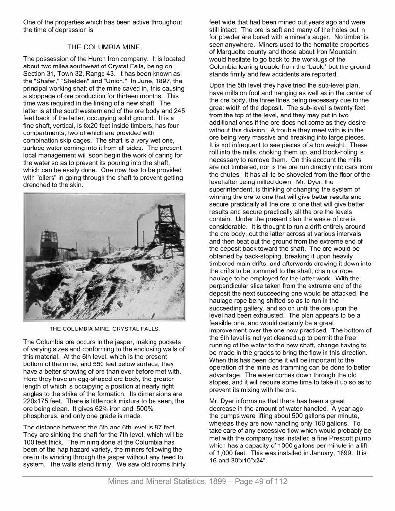
Mines and Mineral Statistics, 1899 – Page 49 of 112
One of the properties which has been active throughout the time of depression is
THE COLUMBIA MINE, The possession of the Huron Iron company. It is located about two miles southwest of Crystal Falls, being on Section 31, Town 32, Range 43. It has been known as the "Shafer," “Shelden" and "Union." In June, 1897, the principal working shaft of the mine caved in, this causing a stoppage of ore production for thirteen months. This time was required in the linking of a new shaft. The latter is at the southwestern end of the ore body and 245 feet back of the latter, occupying solid ground. It is a fine shaft, vertical, is 8x20 feet inside timbers, has four compartments, two of which are provided with combination skip cages. The shaft is a very wet one, surface water coming into it from all sides. The present local management will soon begin the work of caring for the water so as to prevent its pouring into the shaft, which can be easily done. One now has to be provided with "oilers" in going through the shaft to prevent getting drenched to the skin.
THE COLUMBIA MINE, CRYSTAL FALLS.
The Columbia ore occurs in the jasper, making pockets of varying sizes and conforming to the enclosing walls of this material. At the 6th level, which is the present bottom of the mine, and 550 feet below surface, they have a better showing of ore than ever before met with. Here they have an egg-shaped ore body, the greater length of which is occupying a position at nearly right angles to the strike of the formation. Its dimensions are 220x175 feet. There is little rock mixture to be seen, the ore being clean. It gives 62% iron and .500% phosphorus, and only one grade is made.
The distance between the 5th and 6th level is 87 feet. They are sinking the shaft for the 7th level, which will be 100 feet thick. The mining done at the Columbia has been of the hap hazard variety, the miners following the ore in its winding through the jasper without any heed to system. The walls stand firmly. We saw old rooms thirty
feet wide that had been mined out years ago and were still intact. The ore is soft and many of the holes put in for powder are bored with a miner’s auger. No timber is seen anywhere. Miners used to the hematite properties of Marquette county and those about Iron Mountain would hesitate to go back to the workiugs of the Columbia fearing trouble from the “back,” but the ground stands firmly and few accidents are reported.
Upon the 5th level they have tried the sub-level plan, have mills on foot and hanging as well as in the center of the ore body, the three lines being necessary due to the great width of the deposit. The sub-level is twenty feet from the top of the level, and they may put in two additional ones if the ore does not come as they desire without this division. A trouble they meet with is in the ore being very massive and breaking into large pieces. It is not infrequent to see pieces of a ton weight. These roll into the mills, choking them up, and block-holing is necessary to remove them. On this account the mills are not timbered, nor is the ore run directly into cars from the chutes. It has all to be shoveled from the floor of the level after being milled down. Mr. Dyer, the superintendent, is thinking of changing the system of winning the ore to one that will give better results and secure practically all the ore to one that will give better results and secure practically all the ore the levels contain. Under the present plan the waste of ore is considerable. It is thought to run a drift entirely around the ore body, cut the latter across at various intervals and then beat out the ground from the extreme end of the deposit back toward the shaft. The ore would be obtained by back-stoping, breaking it upon heavily timbered main drifts, and afterwards drawing it down into the drifts to be trammed to the shaft, chain or rope haulage to be employed for the latter work. With the perpendicular slice taken from the extreme end of the deposit the next succeeding one would be attacked, the haulage rope being shifted so as to run in the succeeding gallery, and so on until the ore upon the level had been exhausted. The plan appears to be a feasible one, and would certainly be a great improvement over the one now practiced. The bottom of the 6th level is not yet cleaned up to permit the free running of the water to the new shaft, change having to be made in the grades to bring the flow in this direction. When this has been done it will be important to the operation of the mine as tramming can be done to better advantage. The water comes down through the old stopes, and it will require some time to take it up so as to prevent its mixing with the ore.
Mr. Dyer informs us that there has been a great decrease in the amount of water handled. A year ago the pumps were lifting about 500 gallons per minute, whereas they are now handling only 160 gallons. To take care of any excessive flow which would probably be met with the company has installed a fine Prescott pump which has a capacity of 1000 gallons per minute in a lift of 1,000 feet. This was installed in January, 1899. It is 16 and 30”x10”x24”.
Mines and Mineral Statistics, 1899 – Page 50 of 112
They are caving pillars from the 5th to 3rd level about the old shaft where there is a little ore yet to be taken. There is some ground here that cannot be reached. In a short time they will have everything well cleaned down to the 5th level, and when they are in shape to start the new system they will be in better shape than ever before in the history of the property. The upper levels were very bunchy and there was much labor attending the securing of the product. It has not been until recently that the company knew just where its main deposit of ore was, and it was not an easy matter to lay out work for the future. Like several other properties in the Menominee field the deposit has grown bigger and more regular as they have gained in depth, and the Columbia will soon be in shape to send out double its former production. There has been much difficulty attending the operation of the property due to the great amount of water met with and the fact that the old shaft was in bad ground. The engraving shows the location of the old shaft, and the depression caused by the caving which lost the shaft to the company. The new shaft can be seen at the west end of the open pit.
Since taking hold of the property Superintendent Dyer has accomplished much in the way of surface improvements as well as those underground. They have put in a new boiler at the new shaft, a Springfield, 25-horse power, with special advantages in the way of mud holes, The water used is taken from the mine, there being none that can be had from the surrounding country. This makes a very dirty feed, and boilers have to be used that will best take the muddy water. They may put in new hoist, but have not decided upon the kind. The old hoist two 8-foot drums, may be taken to the Mansfield mine which is practically operated by the same people. The old engine house, a roomy one built of brick and stone, will be converted into an office and ware-house.
The company is employing 125 men and will soon be in shape to add considerably to this number. The tramming is done by contract, so much per car, or ton. The mining is done on company account. In this mine it is a question of tramming rather than of breaking, a few miners keeping many men busy getting the ore to the shaft.
The local officers are H. H. Dyer, superintendent; F. U. Nelson, cashier; John Worden, mining captain. The main offices are in Chicago. John Crera is president, M. S. Saunders, secretary.
THE CRYSTAL FALLS MINE. One of the neatest mines in the western end of the Menominee range is the Crystal Falls. Up to 1896, when it was obtained by Corrigan, McKinney & Co., of Cleveland, Ohio, it was little known. It had been worked but little, and up to this time had produced only 18,335 tons. The location of the property is about a mile northeast of the village of Crystal Falls, occupying the northeast quarter of Section 21, Town 43, Range 32.
In its earlier history the small tonnage obtained was from near surface where the ore made in small, irregular-shaped bunches, and where it was taken out in open pits and later through a shaft in the hanging wall of the enclosing formation. The timbers of the old shaft house can be seen in the foreground of the engraving presented, the new shaft, located in the foot, being seen just across the depression made by the mining of the ore.
It was not until the 3d level had been reached that the ore deposit assumed regular proportions. This was 250 feet below surface. At this point the ore body gave a length of about 240 feet, with an average width of 50 feet. The ore is of brownish color, gives from 58 to 59 per cent. iron and .500 to .700 per cent. in phosphorus. It is compact, needs power drills and explosives to successfully mine, is low in moisture and breaks finely in the blasting. It has a dip of 66° to the south and a slight pitch to the west. There is but little water in the mine, the levels everywhere being dry, and no timber is used, the ore standing remarkably well.
The new shaft, which follows the dip of the formation, and is provided with two skip-waps, is located about mid-way on the trend of the deposit. The course of the main ore body is a little north of east and south of west. In the extreme ends of the deposit there is a decided swinging of the ore to the south and west, this being particularly true of the north end of the property where the ore, in a succession of steps, goes to the southwest rapidly. In the 4th level, 100 feet below the 3d, and 350 feet below surface, the ore extends further west and is also of a larger proportion in the extreme western workings than upon the 3d. At 120 feet east of the shaft on the 4th the ore takes a sudden turn south, following this course for about 100 feet when rock cuts it out. They are exploring this end of the mine for a continuation of the deposit, and were following a leader of ore at the time of my visit, which may lead to something valuable.
Indications incline one to the belief that the Crystal Falls will make a considerable increase over its present size as they gain in depth. This has been true of the developments thus far made at the property, the ore being more regular and of larger dimensions with each succeeding level.
In winning the ore of the 3d level they have put in mills every fifty feet and within ten feet of the footwall, these connecting with the fourth level. Twenty feet from the top of the level they start their first cut, breaking the ore into chutes and running it to the level below. The ore breaks well! and there is no clogging of chutes. They underhand stope the ore, and afterward thin the back of the level to a point where it will safely stand. Pillars are left generally where the ore is thinnest, and there is no regularity as to their location. Between the third and fourth level there are now six raises through and into which the ore can be sent. They do not aim to make stockpiles in the winter months, the ore secured being that obtained from preparatory openings—in the getting ready for mining. The ore breaks so readily that it is

Mines and Mineral Statistics, 1899 – Page 51 of 112
hardly necessary to stockpile it; and it saves the cost of extra handling to load directly from the shaft into railway cars. That the Crystal Falls secures an excellent product per man is apparent to anyone who goes through the mine and sees how everything is handled, and the ease with which the ore is obtained. The ground breaks to advantage, and everything has been well planned. There are double tracks in the main level, and when the tracks are laid switches are put in permanently, saving the time and extra cost of adding them later, as is sometimes done. What water is met with is all taken up, and the trammers have excellent footing, and there are no wet stopes. They are sinking the winze for another level, preparing to extend the shaft to the fifth. They raise their shaft, no sinking being done in it. They find this quicker and cheaper than to sink it. The old winze between the third and fourth is being fitted for a chute through which to send the ore from the third level, the new winze being nearer the hanging wall.
CRYSTAL FALLS MINE.
The past winter they added 100 feet to the depth of the shaft, made the necessary crosscut, put in six raises and opened the level, which was doing exceptionally well. The sinking was done with a half-ton bucket. The skips handle two tons each.
There is no contracting at the Crystal Falls, men being paid by the day. The plan works well here. A force of 100 men is now being employed. During the year they added a new boiler 6x20 feet.
The local officers are: S. C. Bennet, superintendent; Edwin Jacka, mining captain; Wm. J. Bosanka, clerk.
Corrigan, McKinney & Co. are prominent in the reviving of the old mines of this field. To the west of the Crystal Falls mine a short distance is
THE GREAT WESTERN mine. This is looked upon as one of the best properties in the Crystal Falls district. During the time it was active it produced 373,100 tons of ore. It was closed down in
the fall of 1892, and the resumption dates from the 11th of December, 1898, at which time Corrigan, McKinney & Co. took hold of it.
There were two vertical shafts at the Great Western, these being located in the ore formation and were 220 feet apart. No. 1 was equipped with two cages and No. 2 with one. No. 1 was the deeper, being to the 10th level, 560 feet below surface. No. 2 is to the 9th level. The ore is a soft hematite, yielding 60% in iron and .500% in phosphorus. The walls of the ore deposit are nearly vertical and an ore body 400 feet long with an average width of 50 feet has been exposed.
The levels were spaced irregularly in the opening of the mine, and many styles of winning the ore were practiced. The greater portion of the product was obtained by rooming upon square sets, which was an expensive plan considering the price at which the ore had to be marketed. Superintendent Bennett will change this and will probably take the ore as he is doing at the Crystal Falls mine.
At the time of the stoppage of work there had been some stoping done upon the 8th level, and very little upon the 9th, so that the present operators will be in shape to make a pretty good showing in 1899 as soon as the water is out. At the time of my visit the water was below the 8th level. The Great Western has always been described as a wet mine, but they never had a pumping plant that was either adequate or economical. They have installed a compound condensing pump with 10-inch water column which was obtained at the Sunday Lake mine. Wish this they are lowering the water rapidly and they will have no trouble keeping the mine dry with this plant. They have two 6-foot drums with a Corliss engine having cylinders 20x42 inches.
It is the intention to replace the cages with skips, these being considered an improvement over the style of cages which were used here.
Immediately adjoining the Great Western upon the west is
THE LINCOLN MINE. This property was closed at the same time the Great Western suspended operations. The workings of the two mines are connected at the 6th level, the 6th level in the Lincoln being 16 feet higher than the 6th in its neighbor. The Lincoln was not prepared to handle the water of the Western when the latter ceased pumping.
The Lincoln has one shaft located in the ore body and 50 feet from the West line of the Great Western. This shaft is to the 6th level. They will sink it to agree with the 8th level of the Great Western, it being under the same management as the Great Western. In the pumping out of the latter the water in the Lincoln was also taken, the connection at the 6th level permitting of this. Power will be provided from the engine house at the Great Western.
Mines and Mineral Statistics, 1899 – Page 52 of 112
There is a heavy rock capping covering the ore body of the Lincoln, it pitching west at an angle of 40°. Due to this the levels in the upper portion of the shaft have been very short, but increase as greater depth is attained. On the 6th they have 230 feet of ore from the Great Western line to their most westerly workings. The ore body is identical with that of the Great Western.
They are now repairing the shaft and will soon be ready to begin active mining. With two levels added there should be a great gain in the length of the ore body. While the mine was worked it produced 36,589 tons of ore.
It is the intention to locate a new shaft in the near future to take the ore from both these properties. Mr. Bennett wishes to get the mines producing and also to do something in the way of testing the ore bodies before deciding upon the location for the new shaft. It will be in the foot wall and about midway upon the length of the ore deposit of the combined properties.
They are repairing the shaft and the mine dwellings houses, and have already done considerable work in this line. A half mile west of the Lincoln is
THE LAMONT MINE, Which is also being revived by Corrigan, McKinney & Co. This property has also been worked under the title of “Monitor.” It was closed down in 1892. It is located on Section 20. The water has been taken out of the shaft and they are now preparing to add another level, which will be the 7th. They are sinking a winze preparatory to raising in the shaft. They have opened up the 6th level, and have exposed a body of ore 200 feet long by 50 feet wide. In quality it is like the Crystal Falls.
There is one shaft which is located in the ore body, is vertical and has two cages. The cages will be replaced with skips. The ore secured here was won by settling the surface, milling the ore down, but there were no chutes provided. These will be added, the plan observed at the Crystal Falls mine to be adopted.
The ore at the 5th level has been worked upon but little, it being practically intact, so that by midsummer they will have three levels ready to draw from. There is little water at this mine. Corrigan, McKinney & Co. are now operating four properties in the Crystal Falls district, the Crystal Falls, Great Western, Lincoln and Lamont. Besides this they are doing a little exploring at the old Quinnesec mine, at Quinnesec, Dickinson county. They are employing, all told, 400 men at their Menominee range properties. The main offices of the company are now at Crystal Falls, having been removed from Negaunee, Marquette range. Mr. E. D. McNeal is assistant superintendent and cashier.
The company has shown much enterprise in the reviving of the old mines, and has evidently worked up a market for the ore. It proves to be an excellent mixture for certain kinds of iron now in demand, and it is hoped the mines can be wrought at a profit long into the future.
THE MANSFIELD MINE. The Mansfield mine, operated by the De Soto Iron company, is one of the best known properties of Iron county. Its location is in the south forty of lot 8, Section 20, Town 43, Range 31, about seven miles east of the village of Crystal Falls.
In 1893 the mine, which was located beneath the bed of the Michigamme river, was suddenly filled with water by the giving away of the roof of the upper level, thus permitting the water coming into the mine. The result was the drowning of twenty-eight Italian miners, and the idleness of the property until 1897. Before resumption could take place it was necessary to divert the course of the river, this being done at a considerable cost, but now there is no further danger from encroachment of water.
The ore deposits of the Mansfield occur in narrow pockets, varying in thickness from four to thirty feet, having an average with of about fifteen feet. It has generally been referred to as being of bessemer grade, but a very small portion of the product can be so classed. They make three grades, Mansfield No. 1 giving 60% iron and .055% phosphorus; Mansfield No. 2 with 56% iron and 85% phosphorus and “Searles,” which contains 58% iron with no restrictions as to phosphorus. It is the only property thus far developed in the county which produces an ore of a bessemer grade, and ships cargoes of that class.
The main shaft is now to the 8th level, having just been reached. It is 100 feet below the 7th. Between the 7th and 8th levels the shaft crosses from the hanging into the footwall of the formation. They have mined the ore tributary to the shaft above the 7th level, leaving enough about the shaft to protect this avenue. At the 7th level they have put two cross-cuts into the hanging, these being in soapstone. There is a crosscut into the hanging sixty feet, which cut mixed ore and jasper, and a second crosscut has been started which they are going to put through for a considerable distance to prove the territory upon that side of the shaft. This will be started from a point near the shaft.
At the old shaft they have secured the ore by backstoping, letting it accumulate upon heavily-timbered drifts and afterward drawing it down to the level. No timber is employed excepting in the main drift. The ground stands remarkably well, proof for which is found in the fact that the back had been worked up to within twelve feet of the river bottom before the catastrophe above referred to took place. The ground was kinder to the property than the management at that time, the latter being responsible for the terrible sacrifice of life. That it stood so long is remarkable considering the weight of the water above. There is still considerable water handled in the mine, it amounting to about 400 gallons per minute, the most of it coming from surface.
The ore makes up to the bottom of the old river bed and can be plainly seen there. To secure the ore of the upper levels of the old shaft, and in territory further south, they are sinking a new shaft, the location of which

Mines and Mineral Statistics, 1899 – Page 53 of 112
is 400 feet south of the old one. This is down 220 feet, and they are both sinking and raising in it to facilitate the work, it being the intention to raise ore from this the present season. With this addition to the mine they will be in shape to produce ore more rapidly than at any time in the history of the property. During 1898 they shipped from the Mansfield 60,739 tons, which was an excellent record considering the size of the deposit and the amount of dead work which was necessary to secure it. In 1897 the output was 37,187 tons. The property has produced in all years 304,877 tons. The Mansfield is not a big mine and a product of 75,000 tons is doing remarkably well.
They are working a force of 120 men and observe the contract system, paying them so much per ton or foot. H. H. Dyer, Crystal Falls, is general manager; E. C. Searles, superintendent.
THE MAAS EXPLORATION. A half mile south of the Mansfield mine, on Lot 6, Mr. Geo. Maas, of Negaunee, Mich., found iron ore with a diamond drill several years since. According to figures he gives as the result of assays made, this ore is of bessemer grade. Diamond drill sludges are not always reliable, but the laboratory tests were satisfactory. An option of this property was secured in April, 1899, by Pickands, Mather & Co., of Cleveland, Ohio, through their local agent, Mr. C. E. Lawrence, of Amasa, Mich. It is the intention to explore the property the present year, and to determine the value of the ore found with the drill at that point.
The valley of the Michigamme river seems a likely place for the finding of ore, and ore of bessemer grade at that. The Mansfield gives evidence that such ore does occur in this territory, and the valley of the stream is certainly well worth giving attention by explorers. Should ore of bessemer class be found it would be a great aid to the county.
Between Crystal Falls and the Mansfield are several old properties which, in these days of greater activity in non-bessemers, may be again given attention. Among the most prominent of these is
THE ARMENIA, Which was first opened up in 1889. It occupies the east half of the southeast quarter of Section 23, Town 43, Range 32, three miles east of Crystal Falls. The trend of the ore formation here is north and south, the diorite enclosing formations having that strike. While active the property produced 78,969 tons of ore, which gave about 60% iron and .008% phosphorus.
THE HOLLISTER Is one mile north of the Armenia. In 1888 4,098 tons were produced here, it being of poor quality. There were two paralell runs of ore, both being narrow, about ten feet wide.
THE WAUNETA, Which is also known as the "Blaney," sunk a shaft to a depth of 110 feet, finding ore of inferior quality.
THE LEE PECK, Half a mile northeast of the Wauneta, produced 2,844 tons in the eighties. The deposit proved small and work was prosecuted upon it for but a short time.
THE DUNN MINE. The Dunn mine is idle, it having caved in during 1898, and nothing has since been done in the way of operating it. It was idle for the greater portion of 1897 due to royalty matters, reduction being sought from the fee owners and this had been settled but a short time when the mine “went together," and there is no sign of a resumption. At the time of the cave-in they were opening the nth level in the northwest end of mine where they had a deposit of ore possessing a width of about 20 feet, and was showing signs of growing larger. The ore had also improved somewhat, yielding from 60 to 61% iron. The Dunn had fine bodies of ore in the upper levels. During 1898 it shipped 69,381 tons, and its shipments to date amount to 1,256,381 tons.
THE YOUNGSTOWN MINE. This property occupies the northwest quarter of Section 20, Town 43, Range 32, about a mile northwest of Crystal Falls. It has shipped 151,425 tons of ore, and has been idle many years. There is a shaft 160 feet deep, and the ore deposit is a large one, being 200 feet wide, with a length not fully shown by developments. The quality of the ore is poor, it giving from 55 to 57% iron. There might be a chance for it in times like the present. Poorer ores are being mined. The ore could be obtained cheaply.
THE PAINT RIVER Mine is just east of the Youngstown. It has produced 222,371 tons of ore. At a depth of 300 feet the ore was cut out by a dyke with a southwest dip cutting it off. There is a fine equipment of machinery but no ore.
THE CLAIRE. This mine is located upon Section 19, immediately west of the Youngstown. It will hereafter be known as "The Bristol,” an organization bearing that name having been perfected to operate it. The property was worked some years ago, producing during the time of its activity 66,964 tons. It was worked principally as an open pit, a little ore being taken from a shaft. On the 8th of March, 1899, they began unwatering the mine. The pit has a depth of 60 feet, is 50 feet wide and 200 feet long, the ore being from 30 to 35 feet wide. It is the intention to mine from both the open pit and the shaft, and the company hopes to sent out about 100,000 tons of ore

Mines and Mineral Statistics, 1899 – Page 54 of 112
this season. The ore is low grade, containing 56% in iron and has some manganese. It can be cheaply mined as it will need no timbering. The ore is very hard and firmly in place, needing power drills to properly prepare for the blasting. They have a small hoisting plant adequate for the needs of the property and are now building an office and repairing a few dwelling houses upon the location. They will build two skip roads. On the east the workings are connected with the shaft put down on the Youngstown by the Illinois Steel company. Mr. O. C. Davidson, of Commonwealth, is general manager, with Arvid Bjork in local charge.
THE HEMLOCK RIVER MINE. This property is located on Section 4, Town 44, Range 33, and the village of Amasa. It has produced 375,046 tons of ore and sent to market last year 69,865 tons. The main shaft is in the footwall, a grey schist, which is very firm, and the ore occurs in this formation, the walls of the mine standing well. During the past winter another level, the 6th, was added. It has a thickness of 90 feet, which was equal to the 5th. They have opened the mine about 350 feet north and 475 feet south of the shaft. The ore is very hard, all of it having to be cut with power drills. They have put in a new Allis compressor, having a capacity for operating 15 drills.
The ore is secured by backstopping, letting the broken material accumulate under foot and working upward to the floor of the level above, as they do at the Republic mine in the Marquette range.
The ore deposit extends beneath the bed of the Hemlock river, and they are working under the stream, but have taken every precaution to prevent accident. Solid cribbing has been put in tightly to the back of the drifts, and no trouble is feared. There is 50 feet of ore in the back, and above this is 25 feet of sand and gravel in the river bed. There is no evidence of water coming through the formation, the mine at this point being dry. There is a raise 700 feet south of the shaft which assists the ventilation.
To the north the ore is getting harder as they work in that direction, and it is now very hard ground in that end of the mine. They work the power drills under 80 pounds pressure. The tramming is done by hand. The skips are 2½ tons, and hoisting drum is 6-foot diameter. A force of 110 men is employed.
Two grades of ore are made, Hemlock, giving 60% iron, and Amasa, giving 57%, the grade being non-bessemer.
The property is operated by Pickands, Mather & Co., of Cleveland, Ohio. C. E. Lawrence is superintendent; Chas. Huges, mining captain; Wm. Jobe, clerk.
THE MICHIGAN MINE, Located on Section 9, immediately south of the Hemlock River, is again being given attention. There were two shallow lifts in the old workings which caved in, drowning
the pump. They have unwatered the workings and have commenced exploring, meeting with some encouragement.
EXPLORATIONS. Iron County will witness more work done in the way of exploring for iron ore than any other portion of the state the present year, 1899. Pickands, Mather, & Co., are picking up lands and will give them systematic search in the hope of finding workable deposits of mineral. Of properties already secured are:
The Greninger, located next east of the Dober mine on the northeast quarter of Section 1, 42-35.
The Forgerty property, located in Section 1, the southeast quarter of the southeast quarter.
The Murphy property, occupying the west half of Section 7, 42-34.
The Stoffel homestead, the southeast quarter of Section 27, 44-35.
The Jas. Wilkinson lands, located in Section 39, 43-33, occupying the territory lying between the Columbia and Dunn mines, near the village of Crystal Falls.
The Andy Boyington property, located in Section 13, is two miles north of Stambaugh. In the sinking of a well at this location 30 feet of ore were located at a depth of 80 feet. It is to prove the value of this that the company has secured an option on the lands.
Mr. Frank Scadden, of Crystal Falls, is now exploring upon the Alpha, on Sections 11, 12, 13 and 14, Town 42, Range 33, and also upon lands of the Great Eastern on the northwest quarter of the northwest quarter of Section 18, Town 42, Range 32.
Deals for other property are now under way by prominent mining concerns, and the outlook for the picking up of all the available mining property in the county is considered excellent. These can generally be gotten at reasonable figures. The quality of the ore does not warrant big ones. To secure a profit the ores have to be mined cheaply and the rate of royalty must low. The deposits must be sufficiently large to permit of large annual outputs and thus, with a small profit per ton, the miners hope to live.
To the north of the Iron River the Oliver Mining company have secured the Miller mine, a continuation of the Iron River deposits. Just east of the Isabella they have the Iron county forty and immediately north of this the Selden forty. South of the Dober they have the Brady forty and just east of this the Morgan forty. These will be explored the present year.
The Minnesota Iron company, the Oliver Iron Mining company, Pickands, Mather & Co., and others are securing options on lands throughout the range everywhere, having tied up fully 125 descriptions.

Mines and Mineral Statistics, 1899 – Page 55 of 112
The East Vulcan, since the foregoing descriptions written, has been secured by Pickands, Mather & Co., and being unwatered preparatory to mining.
THE FELCH MOUNTAIN DISTRICT. This iron-bearing formation of the Menominee range is located twelve miles north of the Menominee range proper. It was active a dozen years ago, and produced some ore of fine quality at the Calumet and Groveland mines. There is a chance for the finding of something valuable in this section. It was never explored thoroughly excepting at few points. It will probably be given attention in the future.
THE FLORENCE MINE, Located in Wisconsin, just across the Michigan border, is to be worked again after an idleness of several years. The ore is a non-bessemer, and the deposit is a large one. Mining is done without the use of but little timber, rooms forty feet wide by fifty in height being safely caaried. There was a large stockpile carried for several years after the mine ceased operation. From this 93,663 tons were shipped during 1898. The mine has a credit of 1,258,689 tons in all years.
THE COMMONWEALTH MINE, Which is located near the Florence, is still operated. It sent out 250,687 tons in 1898, this coming almost wholly from pillars in the mine. The end can be seen and unless something new in the way of ore is found, the property will soon be abandoned. The company is now conducting explorations upon the lands.
THE GOGEBIC DISTRICT. The Gogebic district is the producer of the finest bessemer ores, it exceeding in this respect any of the other Michigan fields. It will average a greater percentage of bessemer grades to the total tonnage shipped of any of the Michigan ranges.
The last to begin business in this state it has produced, for the Michigan portion of the range, 20,940,412 tons of ore. With the product of the Wisconsin portion of the range added the total is 24,781,020 tons. For the year 1898 the range shipped 2,498,461 tons as against 1,799,884 tons for the year previous.
There have been important changes in the ownership of the principal mines of this range which will be referred to in the mine descriptions which follow.
There is yet a considerable territory in this district to be thoroughly explored. The rock formations are regular from the Montreal river as far east as Black river where they generally appear to be much broken and disturbed. They are generally persistent and strong. They rest on the older granite to the south and are overlaid with trap of the Keweenaw series, and have a width at the greatest extent of about three miles. They are tilted
north at an angle of from 60 to 70%. The iron-bearing series is divided into four members: The lowest is a silicious limestone, thin, and is not generally encountered; second is vereigated quartz slate, the upper portion of which is hard, massive quartzite; the third is ferruginous cherts, chists, ore bodies, etc.; the fourth is graywackes, chists, cherty iron carbonates, etc. An interesting and important feature of the geology of the district is the dykes which are met with in all the important mines of the range. These are diabase or diorite, similar to those found in the copper-bearing rocks of the peninsula as well as in the iron-bearing formation of the Marquette district. These dykes generally pitch east of south, and have a dip to the south at nearly right angles to the footwall quartzite. It is in the trough formed by the contact of the dykes and footwall where the ore is generally found, this making a concentrating trough in which the ore was deposited in solution, the ores here being of unquestioned sedimentary orign. These dykes are of varying thicknesses, and for many years there was a much-discussed problem as to whether ore would be found beneath them, This is being answered in the affirmative at several points in the district where sufficiennt depth has been attained. In some places there are several dykes found cutting through the formation. The Ashland mine has any of them, and here they observed all manner of position, being badly split up and thrown out of their usual course.
THE NORRIE MINES. The Norrie mines, located in the city of Ironwood, Gogebic county, and Gogebic iron range, are among the best to be found anywhere. They are big properties, having a yearly capacity of from 600,000 to 1,000,000 tons, depending upon the energy put forth in the mining. They are capable of an putput of 800,000 tons annually for many years to come. This gives an idea of the extent of the underground workings and of the ore formation. Physically, the ore is of the best. It gives 63% iron and 40% phosphorus for the bessemer grades, and the non-bessemers give about the same percentage of iron. It is an ore that sells well and is one from which the annual prices are based. Occupying such a prominent position upon the shipping its influence upon the market is considerable, and its transactions have always been carefully watched by other concerns in the same line of business.
Besides being a large mine, the Norries have now a large concern backing them, they having been secured by the Oliver Mining company, now the biggest producers of iron ore in the world. The company, with its wonderful capacity for the consumption of ores, are in position to work its properties uninterruptedly, which is important to the people who surround them and who depend for a livelihood upon their activity. The Oliver company is also the possessor of mines upon the Mesaba range and ores such as are mined at the Norries are needed as a mixture with the finer grained ores of the Minnesota field. It allows of the best furnace

Mines and Mineral Statistics, 1899 – Page 56 of 112
practice, and it is safe to say that a much higher percentage of Norrie ores could be run in furnace than of Mesaba. The latter are quickly reduced to a powder under the heat of the blast and coarser, sticky ores are needed to mix with them to prevent explosions and the blowing-over, in the stack, of the finer material. Being popular with manufacturers of steel and iron, there is no fear of a closing of the mines because of a lack of demand, as their products will be desired no matter how low an ebb the industry may recede.
TIMBER IN FRONT OF B SHAFT, NORRIE MINE.
The Norries consist of the Norrie, the North Norrie and East Norrie, the locations of which have been described in foregoing reports. They are contiguous and the ore bodies extend across all of the lands of these fee owners, from the Ashland upon the west to the Aurora upon the east.
The fee of the Norrie and North Norrie is owned by Frederick Ayer and J. M. Longyear, while that of the East Norrie is owned by the Keweenaw association. It is needless to say the possessors of the land have profitted well from the royalties paid by the mining companies. The Norries have produced 8,581,227 tons of ore, this amount having been shipped from the mines, and in addition thereto is a large amount of ore now in stock at the shafts awaiting transportation to market. Eventually, the ore deposit of the Norrie will be carried by its dip to the property of the North Norrie. The dip of the ore is north at an angle to the horizon of 61°, while the strike of the mine is slightly north of east by south of west.
The Norries have been opened about three-fourths of a mile upon the trend of the formation and there is yet about 450 feet of ground in the west end of property to be developed, this adjoining the Aurora. In all this distance ore has been found almost continuously. It has been a wonderful mine in this respect. In places the ore body was of great width, showing 275 feet, this being much above the average, of course. Seventy and eighty feet from foot to hanging is common. It was due to these great widths that so large an output has been obtained
at such slight depth from surface. In the Marquette district and Menominee, where such immense outputs have been obtained, the mines are much deeper than here.
In this opening of the mines ten shafts were sunk. Beginning at the west end are found Nos. 1, 2, 3, 4, 5, 6, and 7 on Norrie lands and succeeding them going east are Nos. 1, 2 and 3 East Norrie. These shafts are all sunk in the ore measure. When the mines were first opened those in charge were evidently desirous of getting a product into the market as soon as possible. Ore was then selling at a big price, and by putting the shaft down in ore the cost would be less than sinking in the footwall rock, and besides there would be ore coming from the openings to pay the cost of sinking. This was the general practice upon that range, and has since proved a very costly one. There has been constant settling of the ground about the shafts which has required constant attention, several of the shafts were lost by caving ground, and besides all this there has been a large amount of ore tied up as retaining pillars to prevent the shafts from collapsing.
In the west end of the property there is considerable ore that is now being reached from No. 5 Norrie. They are going through the old caves taking the ore wherever they find it. Much of this ground came together at the time of the idleness of the property during the late financial depression, and was not re-opened until lately. There is also a lens of ore to the north of No. 2 shaft which is being now looked for from the 10th level of the shaft, this depth having lately been reached in order to prosecute the exploration properly. The ore is an extension of a deposit found in the Ashland mine and which was worked up to the boundry line between the Ashland and Norrie. Mr. Cole informs us that nothing was ever done upon this ore upon the Norrie side of the line and is confident it will be found upon Oliver property. Just how important it will prove in size and quality remains to be seen.
In the old No. 5 they are working from the second level to the seventh on both sides of the shaft, taking pillars and floors which had been left in the original mining. They are now preparing to go into No. 6 shaft to prosecute work similar to that being done at No. 5. East of this shaft there is still considerable ore exposed on the 6½ and 8th levels.
At No. 7 they have recently found ore to the east of the shaft and upon the hanging side of thee deposit where originally the dyke seemed to have cut the ore out. They cut through into what was supposed to be the hanging wall and are now into ore about 20 feet. Like cases have been found at other points.
The dykes, as is generally well understood, cut through the ore formation at about right angles to the footwall quartzite, and it is in the trough made by the contact of the quartzite and the dyke that the ore is generally found. It has been a much-mooted question whether ore would be found beneath the dyke. At this point it has
Mines and Mineral Statistics, 1899 – Page 57 of 112
been, and this is true of other places upon the range of which we will have more to say in other descriptions. Mr. T. F. Cole, superintendent of the Norries and of all the mining properties of the Oliver company, has his ideas regarding the occurrence of ore beneath the dykes. He is of the opinion that wherever there are iron-bearing formations under the dyke that there will be found ore bodies also, as there was offered the opportunity for the ores to be deposited in solution, following downward with the dip of the banded jaspers and cherts, until obstruction was offered by other dykes at lower depth, when bodies of ore would be formed. So long as there is found ferruginous rocks between the dykes he expects to find ore, and this is given color to by diamond drill borings made upon the property of the company and conducted by the Metropolitan Iron & Land company some years ago. This exploratory test indicates no less than six dykes with 95 feet of ore beneath the 5th at a vertical depth of 1462 feet. The thickness of the dyke overlying this body of ore was 92 feet. Following this 95 feet of ore was a dyke eight feet thick after which was found 28 feet of ore lying upon the footwall. If the reading of the were correct then the future of the Norries, as well as other properties upon the range in that vicinity, is assured for a long time.
At the East Norrie mine they are working upon the 9th, 10th and 11th levels and are sinking No. 3 shaft for the 12th level. This is now the biggest part of the mine. At the 8th level of No. 3 shaft they have a drift connecting with the Aurora mine.
An important work under way and fast nearing completion is the sinking of B shaft. This is located 500 feet north of No. 1 shaft, East Norrie. It was begun several years ago. It is located in the hanging wall, but is far enough back from the ore bodies as now developed that it will not be pulled out of line by “drawing” ground for some years to come. It is 520 feet north of present northern limits of the ore. It will strike the footwall at a depth of 1200 feet. It is a big shaft, 8x22 feet inside of timbers, and has four compartments. In two of these cages are now operating, and in the remaining two will be skips. The cages will be used for the handling of men and timber while the skips will take care of the ore. Over the shaft is a shaft house 86 feet high and covering a ground space of 42x50 feet. It is a substantial structure, showing no signs of weakness anywhere. It is the intention to not sheath the house, but to treat it to a coat of fire-proof paint. The reason for not enclosing it is to lessen the danger from fire.
The shaft is now down 650 feet. It is connected with the mine workings to the south at the 7th level and the crosscut from the 9th is nearly finished. They are driving this both from the shaft and the mine to hasten its completion. The cages used here are high, giving plenty of head room, and are from the company's local shops. They handle twenty-two men each, and are worked in balance, and Mr. Cole informs us they can take every man out of the mine in twelve minutes.
There is a fine equipment of machinery at this shaft. The hoist is a Bullock, has two 24x48-inch steam cylinders connected direct to two drums which are 8-foot diameter by 9-foot face, holding rope for a 2000-foot shaft. There are steam cylinders for operating clutches and automatic stop device which will check the cage at a distance of eight feet in case of accident or neglect. The drums are detachable and it is the intention to use one for skips and the other for cages. It is figured that with one drum they can hoist 600,000 tons of ore fro this shaft. We noticed that the sheaves were very large and all were wood-filled, running smoothly and noiselessly.
The object is to have this the main hoisting shaft for the mine. It is the intention to abandon No. 1 East Norrie shaft this season. It is in ore, much being left to support it. Later on it is the intention to abandon No. 2 East Norrie and Nos. 6 and 7 Norrie. The ore from these shafts will be sent to B shaft. They have already contracted for an electric haulage plant which will be installed as soon as possible. It will be similar to those used at the Lake Angeline and Cleveland mines, Ishpeming. There will also be electric haulage for the handling of ore upon surface. This will be an important improvement.
Eventually there will be considerable stocking of ore upon this side of the mine, and all buildings erected here in future will be well back of the shaft to prevent any trouble which might arise from a settling of ground. To the north of the shaft is located the engine house, it being a new structure. The engine house originally built was decided to be too close to the shaft and they are now using it for a machine shop. On the west side of this building they are laying a new compressor foundation. A new blacksmith shop will be built close to the machine shop so that it will be convenient for the business of both. The machine shops are finely equipped and much new work is turned out. There will also be a yard fitted up for the storage of apparatus not in use. There is a new boiler being put in place at this shaft, a Cahall, vertical tube.
In the mining of the ore they are observing the caving plan wherever it can be employed to advantage. On the foot side the ore is generally very hard and firm and does not follow down readily. In these places they are taking the ore on square sets, the plan formerly practiced throughout the mine. At No. 3, East Norrie, they have taken ground a set wide clear across the deposit and to the top of the ore, using this for a mill. The ground stands remarkably well. At the 10th level in No. 2 shaft they have found a new piece of ore on the hanging side of the vein where the dyke is broken. Between Nos. 1 and 2 shafts, East Norrie, there is a vertical dyke. It is broken at its contact with the hanging, and they have yet failed to located the other end of the piece.
All sizes of timber are used underground, and there is considerable hardwood, this being much used for cribbing and drift sets. The engraving shows a big stock of timber in front of the new B shaft. The hardwood is
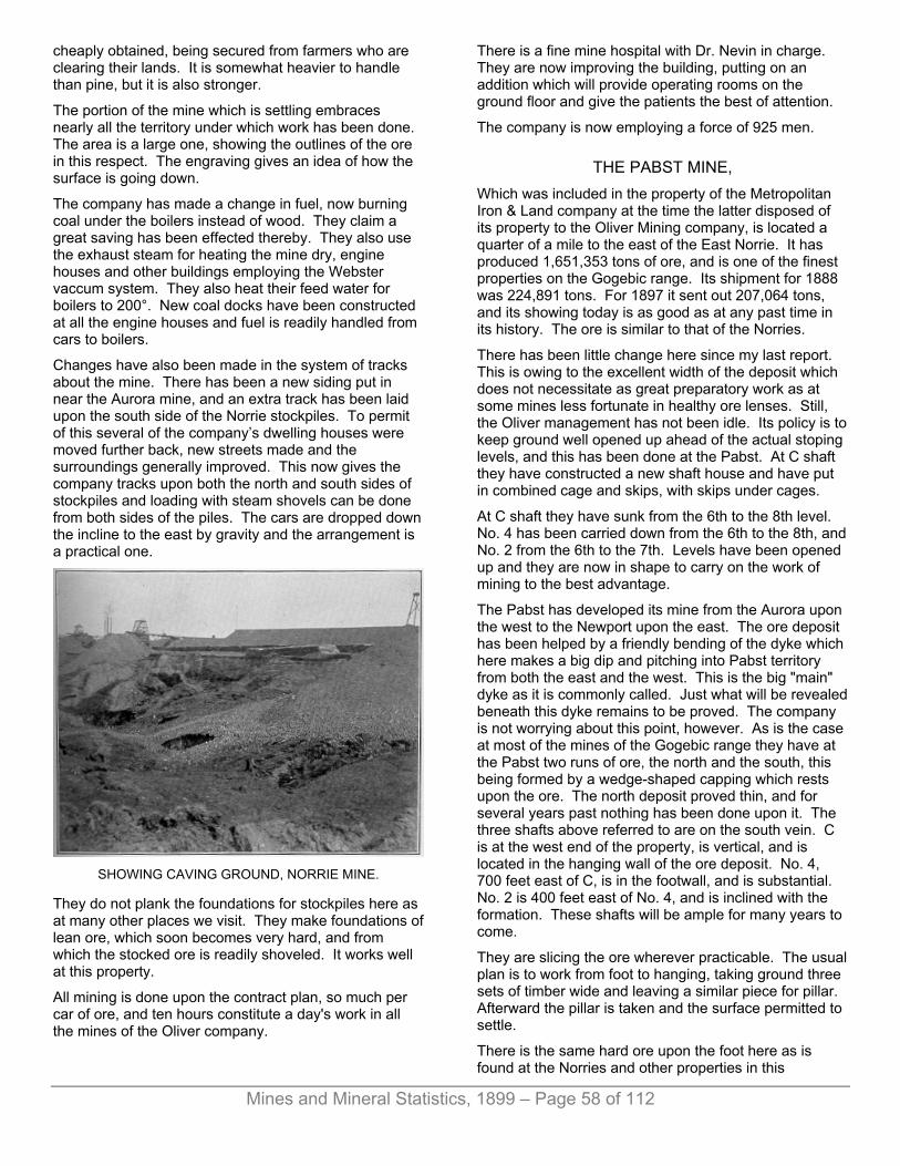
Mines and Mineral Statistics, 1899 – Page 58 of 112
cheaply obtained, being secured from farmers who are clearing their lands. It is somewhat heavier to handle than pine, but it is also stronger.
The portion of the mine which is settling embraces nearly all the territory under which work has been done. The area is a large one, showing the outlines of the ore in this respect. The engraving gives an idea of how the surface is going down.
The company has made a change in fuel, now burning coal under the boilers instead of wood. They claim a great saving has been effected thereby. They also use the exhaust steam for heating the mine dry, engine houses and other buildings employing the Webster vaccum system. They also heat their feed water for boilers to 200°. New coal docks have been constructed at all the engine houses and fuel is readily handled from cars to boilers.
Changes have also been made in the system of tracks about the mine. There has been a new siding put in near the Aurora mine, and an extra track has been laid upon the south side of the Norrie stockpiles. To permit of this several of the company’s dwelling houses were moved further back, new streets made and the surroundings generally improved. This now gives the company tracks upon both the north and south sides of stockpiles and loading with steam shovels can be done from both sides of the piles. The cars are dropped down the incline to the east by gravity and the arrangement is a practical one.
SHOWING CAVING GROUND, NORRIE MINE.
They do not plank the foundations for stockpiles here as at many other places we visit. They make foundations of lean ore, which soon becomes very hard, and from which the stocked ore is readily shoveled. It works well at this property.
All mining is done upon the contract plan, so much per car of ore, and ten hours constitute a day's work in all the mines of the Oliver company.
There is a fine mine hospital with Dr. Nevin in charge. They are now improving the building, putting on an addition which will provide operating rooms on the ground floor and give the patients the best of attention.
The company is now employing a force of 925 men.
THE PABST MINE, Which was included in the property of the Metropolitan Iron & Land company at the time the latter disposed of its property to the Oliver Mining company, is located a quarter of a mile to the east of the East Norrie. It has produced 1,651,353 tons of ore, and is one of the finest properties on the Gogebic range. Its shipment for 1888 was 224,891 tons. For 1897 it sent out 207,064 tons, and its showing today is as good as at any past time in its history. The ore is similar to that of the Norries.
There has been little change here since my last report. This is owing to the excellent width of the deposit which does not necessitate as great preparatory work as at some mines less fortunate in healthy ore lenses. Still, the Oliver management has not been idle. Its policy is to keep ground well opened up ahead of the actual stoping levels, and this has been done at the Pabst. At C shaft they have constructed a new shaft house and have put in combined cage and skips, with skips under cages.
At C shaft they have sunk from the 6th to the 8th level. No. 4 has been carried down from the 6th to the 8th, and No. 2 from the 6th to the 7th. Levels have been opened up and they are now in shape to carry on the work of mining to the best advantage.
The Pabst has developed its mine from the Aurora upon the west to the Newport upon the east. The ore deposit has been helped by a friendly bending of the dyke which here makes a big dip and pitching into Pabst territory from both the east and the west. This is the big "main" dyke as it is commonly called. Just what will be revealed beneath this dyke remains to be proved. The company is not worrying about this point, however. As is the case at most of the mines of the Gogebic range they have at the Pabst two runs of ore, the north and the south, this being formed by a wedge-shaped capping which rests upon the ore. The north deposit proved thin, and for several years past nothing has been done upon it. The three shafts above referred to are on the south vein. C is at the west end of the property, is vertical, and is located in the hanging wall of the ore deposit. No. 4, 700 feet east of C, is in the footwall, and is substantial. No. 2 is 400 feet east of No. 4, and is inclined with the formation. These shafts will be ample for many years to come.
They are slicing the ore wherever practicable. The usual plan is to work from foot to hanging, taking ground three sets of timber wide and leaving a similar piece for pillar. Afterward the pillar is taken and the surface permitted to settle.
There is the same hard ore upon the foot here as is found at the Norries and other properties in this

Mines and Mineral Statistics, 1899 – Page 59 of 112
immediate vicinity. and in mining it they observe the same plans as practiced at the Norries.
The Pabst is engaging a force of 475 men, giving the Oliver company's total number of employes for Ironwood alone 1,400.
THE NORTH AURORA. The Olivers have secured possession of this property which lies immediately north of the Aurora and East Norie mines, and adjoins the Pabst on the west. There has been some exploring done but nothing of value found. The parties who conducted the work did not go deep enough to find the northern extension of the Norrie and Aurora ore upon its dip. It is a promising piece of property and will be given attention by the present owners at some time in the future.
The Olivers have secured town property to the west and will be in position to take advantage of any extension of the ore in that direction.
Dr. Nelson P. Hulst, of Milwaukee, is general manager of the mines of the company; T. F. Cole, Ironwood, is superintendent of the mines of the company. The local representatives are: J. H. McLean, assistant superintendent for mines on the Gogebic range; Frank Drake, chief engineer for all mines of the company; J. Kellerschon, assistant mining engineer; F. L. Barrows, cashier; Irwin Sutherland and John Luxmore, mining captains, Norrie mines; John Tregambo, mining captain, Pabst mine; W. Bayliss, chemist; Wm. Cole, master mechanic,
The Olivers have a hustling management. Dr. Hulst is an excellent director, while Mr. Cole knows all there is to the mining business. He is full of energy, keeps everything in motion, gets the ore to surface, gives employment to labor, pays good wages, and is just the kind of man to successfully meet foreign competition.
Thee city of Ironwood can rest easy as to its business future for some time to come. It has a powerful aid in the Oliver company; it has fine ores, and the market will want them.
THE AURORA MINE. The Aurora mine, the property of the Penokee & Gogebic Development company, occupies a position immediately between the East Norrie and the Pabst mines of the Oliver Mining company. It has been a fine mine, producing, since work first began, 2,403,188 tons of ore. Its shipment for 1898 was 133,076 tons. This was 33,046 tons less than sent out during the previous year, and is accounted for in the stoppage of the mine, due to caving ground. There has been considerable trouble with accidents of this kind. In the earlier history of the property the mine was worked on the rooming plan, winning the ore on square sets, and later this style was abandoned to employ more modern ones, and those better suited to the conditions met with. At the
time the later change was inaugurated the mine had many levels opened and it has been a slow and difficult task to take the ore of the old floors and pillars in order to bring the mining all to one level in the mine. Captain N. B. Roscorla, who has had charge of the property since the late change in methods of taking the ore was inaugurated, has shown himself competent and practical in every way. He has done excellent work for the company, and the wonder is that he has been able to annually send out so big a product in the vace of the many obstacles he has met with.
No. 1 shaft, located at the extreme western end of the property, is to the 12th level. It is in the ore measure, is inclined, and the bottom is 720 feet from surface. At the bottom they met a heavy water flow, and nothing further will be done in the way of sinking until the big new shaft going down to the north is completed. They put in a crosscut on the hanging side of No. 1 a few months ago and at 285 feet found a body of ore. Just how big this will prove remains to be seen.
As thus far tested it has a thickness of from 18 to 20 feet, the ore being of good quality. They are following it upon its strike to the west and it is looking promising. It may go through to the East Norrie line. The Norrie people are not within eight hundred feet of this point in their workings, and may not be opened as far north so as to catch the western extension of the ore should it make so far in that direction.
At No. 2 shaft, Aurora, they started last fall, 1898, to take out the shaft pillars, and were engaged in this work up to about the first of April, 1899, when they had a bad cave which extended from the 7th to 9th level, and which took a few weeks to repair.
There was only little support left by the former operators in this portion of the mine and the task of taking the shaft pillars and those located in close proximity to the shaft has to be prosecuted with the greatest caution. This shaft was idle for some years, and the only reason the lower levels were kept open were to permit of the flow of water through this portion of the mine to No. 3, further east, and where the main pumping station of the mine is located.
At No. 3 they are working at the 11th level on top of the dyke and have about a year's supply of ore at this point.
At No. 5, in the foot wall, and the only shaft so located, they have not added any levels since my last report. This shaft is to the 7th level. It was put down a few years since to take the ore from this end of the property, the old shafts having to be abandoned. There had been caving of ground brought about by the weight of the surface which the square timbering plan would not support, and then the Pabst, the close neighbor of the Aurora, was caving its ground, and this aided in the troubles of the Aurora. With this shaft they can take all the ore on top of the dyke at this end of the mine.
The big new shaft referred to is located 850 feet north of the line of shafts now working. It is vertical, three-

Mines and Mineral Statistics, 1899 – Page 60 of 112
compartment and is 18'3"x7'6" inside of timbers. A steel shaft house has been erected over it, the only one of its kind in the Michigan fields. It is manufactured by the Variety Iron Works, of Cleveland, Ohio.
This shaft is now to a depth of 800 feet below surface and they are meeting with considerable water, which is delaying the sinking. At the present depth they are cutting out a pumping station and will locate two big pumps here. The water flow at present is about 500 gallons per minute.
This shaft is to be continued until a point 1200 feet from surface is reached, and in the meantime they will be putting in crosscuts to the south from it to connect with the ore deposits of the mine. With these completed they can abandon the old shafts, taking all the ore now retaining them, and conveying it to surface through the new avenue. This is the plan being carried out at the Norrie mines to the west. It is also expected that there will be considerable new ore developed by the new shaft. Diamond drill borings made from the bottom of the old mine indicate that there is a considerable body of ore beneath the present bottom of the old shafts, and it was this which had more to do with the sinking of the new shaft than anything else. If the company’s hopes are realized on this point it will mean much to their active future as well as to Iron wood, in the corporate limits of which city the mine is operated.
At the new shaft they have added another boiler of 250 horse-power capacity since my last report of the mine. The company is employing 275 men.
The fine new hoist at the new shaft was fully described in my last account of the property. It is one of the most complete equipments on the Gogebic. The Aurora is one of the neatest mines about surface to be found anywhere. Captain Roscorla is a stickler for having everything in its place, and it is a pleasure to visit the property.
Mr. W. J. Olcott, Duluth, is general manager of the mine.
THE NEWPORT MINE Occupies a high rise of ground immediately to the east of the Pabst mine. It is operated by Ferdinand Schlesinger and still retains its old title of “The Newport Iron Company.” For 1898 it sent to market 196,953 tons, exceeding the product of 1897 by 39,9758 tons. It has a record of 1,453,263 tons.
Of late years the Newport has not been an easy mine to handle. Its ore bodies have been much split up, have been irregular, and it has taken a great deal of dead work to get the property in shape for production. This is a great contrast to the conditions which prevailed when mining was carried on nearer surface. Then the ore bodies were large and regular and almost entirely free from rock intrusions; and the cost was easier to keep down than at present when so much is needed for the opening and developing of new territory.
As is true of its neighbor, the Pabst, the Newport has two ore veins, the "north" and "south." On the north vein the shafts are numbered and upon the south run of ore shafts are lettered. Up to within a few months ago nothing had been done upon the north vein for several years. They are now taking shaft pillars between shafts Nos. 1 and 2. There is considerable ore here yet to be mined between the shafts and upon top of the dyke. Some work is also being done at different points between Nos. 2 and 4 shafts, scramming out the ore here and there wherever it can be found. There has been considerable ore revealed in some of the old levels where it was supposed the deposits had been exhausted, but the present year will see it pretty well cleaned out.
At "K" shaft, which is at the east end of the south vein as thus far exploited, they are continuing the development of the ore body which they have been working upon for several years past. Since my last report they have added the 10th level, which has a thickness of 110 feet, and are well along for the 11th level which will be 50 feet below the 10th, and 775 feet below surface.
From the 10th level they put in a drift 303 feet to the west before the ore was encountered. They are now in 16 feet of ore of fine quality. They are mining about 150 tons per day, which comes from the west end of the property. The ore at this point is considerably further away from the shaft located in the footwall, At the 9th level ore was struck at a distance of 217 feet from the shaft, while no feet deeper it was 303 feet away. There is a small dyke met with which has caused a throwing of the ore to the west.
At the 9th level of K shaft they had figured to take the ore on the caving plan but were unsuccessful, it being too hard to come down as they should have had it in order to secure a successful working of the plan. Failing in this they cut out the level in two calling the upper portion the 8th level and the lower the 9th. The ore in some places is very stubborn, and will not settle from the hanging so that it can be mined to the best advantage.
They have a decided faulting of the dyke in this shaft, and this has permitted the finding of ore beneath the main dyke. There has been much speculation indulged in as to whether or not there would be menchantable deposits of ore revealed under the dykes of this range. It has been clearly proved at several mines that the ore does make beneath them, and that it exists at a depth of at least 1,500 fest at one point.
The management has hopes of finding the main dyke of the Norrie mine at a depth of 400 feet below the present bottom level at K shaft. Calculations have been made upon the pitch of the Norrie dyke which comes in from the west, and it is thought that it should be found at about 1,500 feet from surface.
At A shaft there is also a plain faulting of the dyke, and there has been considerable disturbance of the formation at this point. At this shaft, as well as at others on the south deposit, they are taking pillars. Nothing
Mines and Mineral Statistics, 1899 – Page 61 of 112
new is being opened up. At F shaft, located a short distance from the mine office, and which was an exploring shaft started some years since and worked in but a short time, they are now doing some work with a view to testing the formation at this point. They have pumped out the water and have done about 400 feet of drifting, finding nothing of value.
It is at greater depths that the company hopes for ore to give them an excuse for continued products. They have opened upon the trend of the mine a distance of 2,200 feet, and while they have territory still practically unexplored they have an idea that they ought to have a continuation of the big deposits of the Oliver Mining company which are located to the west of their line, and which have been very persistent in their strike.
The company is mining about 19,000 tons of ore per month and has neat stockpiles from which to begin shipments this year. A force of 325 men is employed.
J. R. Thompson is superintendent; Thomas Oliver, mining captain; V. B. Sherrod, engineer and chemist; M. E. Russel, cashier.
THE BLUE JACKET MINE. This property is located just northeast of the Newport, embracing the southeast quarter of Section 18, Town 47, Range 26. Four shafts were sunk upon it prior to 1886, and since that date nothing has been done. The property has been secured by Captain William Stephens, of Ironwood, who will explore it this year. He has an idea that work done further north from the footwall than previous explorations will bring better results, and he will begin upon this theory. While it was active the property produced 1,799 tons of ore. Captain Stephens held the position of mining captain for several years at the Newport mine and is familiar with the formations of that vicinity. He will go outside of the old shaft in beginning his explorations.
THE DAVIS MINE. This property, which is next east of the Newport, has of late sprung into prominence by reason of the discovery of a body of manganiferous ore. Its product has ever been of this class, and the Newport also produces a grade of ore running high in manganese, this being from the K shaft at the eastern end of the property. It was abandoned in October, 1885, the ore being cut out by the meeting of the dyke and hanging. In the time it was active it had produced 48,714 tons and the last work done was by the Metropolitan Iron & Land company.
An organization under the title of "The New Davis Mining company” has just been perfected for the reopening of the property. J. C. Moore is president; L. C. Walker, secretary; F. J. Hager, treasurer. All these gentlemen are residents of Ironwood, Mich.
They are now stripping the surface from a body of ore and several test pits are down. A shaft has also been
started. It is the intention to have the railway track relaid to the property and to ship ore the coming season. It is yet too soon to give any idea of the value of the new find. Those directly concerned believe they have a valuable possession and will operate it vigorously this season.
THE ASHLAND MINE. This mine, which is the most easterly of the Michigan end of the Gogebic range, is still working, but the date of its closing is only a short time in the future. For the past few years they have confined their efforts to the taking of shaft pillars, and this work is now nearly finished. They are working about 125 men and last year sent to market 123,208 tons, making the total tonnage since the mine started 2,224,966 tons. The lower levels of the mine are full of water, and much water was made in the lower levels before the closure.
There are many who believe there is ore to be had under the present bottom of the mine, and the excessive water may have prevented the finding of it. This is merely speculation, however. The formation was badly split up with dykes, many of them being found. No other property on this range was so prolific in this intrusive rock. Dykes were met with everywhere. They were of all sizes and observed all positions.
In robbing out the pillars they have sliced them from the top downward, and have secured a surprisingly big product from the operation, it greatly exceeding the estimate which was made for ore when the process was first begun.
The property is operated by the Penokee & Gogebic Development company. Captain T. H. Davey has charge of affairs underground; George H. Durkee, is cashier; W. J. Olcott, Duluth, general manager.
MINES OF BESSEMER. Bessemer, the county seat of Gogebic county, is showing considerable improvement in business activity due to the bettering of the condition of the iron market, and it expects to enjoy a still greater measure of prosperity in the near future. There is a large tract of land lying to the west of the town where there is hope of finding new mines, and, while there has been considerable work done in this section, much of it has not been well directed, or was not carried to proper completion. The ore seems to be deep-seated, and exploration has not been generally been carried downward sufficiently far to find the big dyke which traverses this district and which carries the largest bodies of ore. To the east there is a chance for adding to the present number of working mines, and the improved demand for iron ore will doubtless induce the energetic exploration of this section. Already there is a fair beginning, several of the old properties having resumed. The town of Bessemer found an excuse for existence in the discovery and development of

Mines and Mineral Statistics, 1899 – Page 62 of 112
THE COLBY MINE, Which at one time enjoyed a natural reputation for the magnitude of its ore lenses and ease with which the mineral was mined and loaded upon cars. Its proportions as shown near the surface were the cause of no little uneasiness on the part of miners of other fields who imagined they saw in the new competitor a formidable antagonist which was to greatly injure profits. A steam shovel was placed in one of the big lenses and the ore scooped out from its original resting place directly into the railway cars. This work was done for only a briefs period, however, due to a caving of the side of the pit in which the work was progressing.
The surface showing in the mine was far better than found at points lower down. The lenses gradually grew smaller with each season's mining until finally those in possession of the lease, Penokee & Gogebic Development company, released it. For two years thereafter the mine was idle. In the summer of 1895 property was reopened by Corrigan, McKinney & Co., since which time they have produced 224,271 tons, securing 152,895 tons in 1898.
They have been taking a large pillar about the old No. 5 shaft and have found bunches of ore at various places in this vicinity in the old workings. The ore at this end of the property carries considerable manganese which was objectionable a few years since, but consumers are now not so particular.
There are two ore formations here, as are found further west on the range, at the Newport, Pabst and other mines, and the principal attention has been given to the south. Captain Peter Ramquist, who has charge of the affairs of the mine and who has been an excellent record at this point, has given attention to the north range for several months past, and is going to exploit it in the hope of finding something of value. He is diamond drilling, two drills being used, and will thoroughly test the formations of this locality. He produced 13,000 tons here in 1898. He is also adding a new level at the old mine, and hopes to find something to reward him for the expenditure. The old mine is looking poorly, and another level is necessary to prove what there is in the bottom of the property. A force of 175 men is employed, and the amount of ore secured has been a surprise to many mining men in this field who had looked upon the property as being all worked out. The Colby is in Section 16, Town 47, Range 46. On Section 15, adjoining the Colby immediately upon the east is
THE TILDEN MINE. This is one of the most valuable properties upon the Gogebic range, and because of this is now the property of the Oliver Mining company, who seem to have been selecting the best and purchasing them, their operations extending over all iron ore ranges of the Lake Superior region. The ore deposit of the Tilden has been proved for a mile in length, extending from east to west across the whole of Section 15. It is the same run of ore upon
which the Colby mine, located upon the west, and the Palms mine, on the east, has been given attention for many years, and it has been a most regular deposit, lying, as thus far exploited, on top of the big main dyke which extends throughout this section.
Those who first opened the Tilden mine made the same mistake that did many others on this range. They put all the shafts but one in the hanging wall of the deposit. This is causing considerable annoyance. While there is a very heavy rock capping covering the ore at this property, the deposit is large, having a width of anywhere from 50 to 100 feet, and when the ore has been taken it leaves very large openings. Gradually the surface has been settling, and great cracks now appear at No. 9 shaft, which for several years past has been one of the principal active ones at the property. This shaft is 3,000 feet from No. 6, the most western. The surface shows weakening all along the line of shafts, going west from this point, and it is feared that trouble may be had keeping the shafts in working condition. The shafts, with the exception of No. 8, 700 feet from No. 9, are vertical, are three-compartment, and 7'6"x18’3" inside of timbers. They are expected to reach the footwall of the ore deposit at a depth of 1,100 feet, and have about 500 feet to go to strike this point. No. 8 shaft was in the footwall and inclined with the dip of the formation, but was too close to the ore body. The footwall was also affected by the mining, and the shaft was drawn out of shape and had finally to be abandoned.
At some time it may be necessary to sink a shaft in the foot to take the ore about these vertical hanging wall shafts. While the shafts will eventually pierce the footwall, the trouble will be in maintaining them above the point where they pass through the ore. And these shafts in the hanging tie up an immense amount of ore that has to be left to keep the shafts from collapsing. At some time a big footwall shaft will probably be put down and the ore sent to it from the mine by fast-moving cars.
A point at which considerable interest has centered the past year has been at No. 10 shaft, 1,300 feet east of the No. 9, and 1,300 feet from the company's east line. From the fine showing made in No. 9 it was expected that the ore at No. 10 would be encountered at the shaft further east, and at a somewhat greater depth. The big dyke seemed to be making deeper going east from No. 9. There is a depression in the surface here, the ground lowering rapidly going from the end of the high Colby hill to the valley between this point and the Palms mine hill and it was thought that the dyke carrying the ore would be at a lower level than where it was worked upon at No. 9. They sunk the shaft to the 12th level, put in the crosscut towards the foot and found no ore. They drifted east and west upon the level thinking they might have encountered a piece of barren ground, but no ore rewarded their search. A raise was then put in from the level, and at 14 feet above the level a dyke was found carrying the ore. The dyke proved thin. It ought to have been 100 feet thick to correspond to the dyke to the

Mines and Mineral Statistics, 1899 – Page 63 of 112
west. Mr. Cole has an idea that the dyke may be split and that it will be found in place at greater depth, and carrying ore. The ore found gives evidence of being of considerable width although enough has not been done as yet to prove this point fully. They are following it upon its trend, opening out a level.
The union shaft is upon the dividing line between the Tilden and Palms properties. One compartment of this shaft is owned by the Tilden people.
This shaft has found the ore of the Tilden run and it positively proves a continuous deposit of ore upon the Tilden section for more than a mile in length.
The company is now working Nos. 7, 9 and 10 shafts. No. 1 6 may be given attention later in the season. There is considerable ore at this point, but it is high in manganese. It is to the 525-foot level, No. 7 to the 590-foot.
All the shafts, with the exception of No. 10, are upon high ground. Mr. Cole says it is his experience that the ore in the low ground on the Gogebic range is apt to be considerably split up, the formation being more irregular than upon higher elevations. He refers to the Ashland, Newport and Tilden in support of his statement. He says the dykes are more irregular and there is much splitting up of the formation in the valleys. Black river, to the east, is another proof of the presentation.
There has been no change in the method of winning the ore at the Tilden. Capt. Piper is handling the mine admirably, and is making as low a mining cost as any property on the range. They cut from foot to hanging two sets in height, and let the ore funnel down by its own weight, it running freely. It is simply a “drawing” system, and at no other place does it work more satisfactorily than here. The hanging will remain for some time after the ore is removed before following down. Eventually it will come, and at places it is now coming, this being plainly evidenced by the big cracks which are showing upon the surface about No. 9 shaft. Some of these cracks are three feet wide and are several hundred feet deep. There is no sign of anything but a gradual settling, and no danger is expected from a sudden giving away of any large area of hanging wall.
The securing of ore at the Tilden has always been a question of trammers rather than of miners, and trammers really hold first place underground in the matter of wage getting.
The ore comes readily. After the levels are opened the ground stands finely notwithstanding the fact that in places the ore is soft enough to be bored with an auger, and this is sometimes used in making holes for the dynamite. Mules are employed to do the tramming. The Tilden is a dry mine, 180 gallons of water being all that is pumped from the great underground territory. A portion of the surface water is sent into town for portable use, it being very pure.
At No. 10 shaft they have put in a railway spur and are ready for ore shipping, from the stockpile and shaft
pockets. They are heating their buildings as at the Norries with the Webster vacum heating system using the condensed steam in place of live. They also heat their feed water to 200 degrees. The number of men employed is 475. The total tonnage produced is 1,838,453, of which 287,203 tons were mined in 1888.
N. P. Hulst, Milwaukee.; general manager; T. F. Cole. Ironwood, general superindendent; James Piper, mining captain.
THE PALMS MINE. This property lies next east of the Tilden and is operated by the Dunn Iron company, whose principal is Ferdinand Schlesinger, of Milwaukee.
J. R. Thompson, of the Newport mine, has general charge. Two years ago there was an excellent showing of ore, a fine lens being worked at the 12th and 13th levels, but the 14th level was a great disappointment. The drift on this level where driven at the regular distance from the one above was all in rock, the ore having cut out entirely at this depth. They put raises in from this drift and found the ore above, which they are milling to this level. The dyke encountered here is about 35 feet thick, and it is thought that it may not be the main dyke, which at this end of the mine appears to have swung away from the footwall. At the east end of the mine they have also found a small lens of ore on top of the dyke at the 13th level. This work is being done from the Union shaft, here called No. 5, on the line of the Tilden and Palms properties.
They are preparing to open up the old No, 1 shaft, which is near the east line of their property. They hope to find the extension of the Anvil mine lens, the Anvil being immediately east of the Palms, and had a healthy ore deposit at that portion of the property. Near No. 5 shaft is No. 4, which is connected with the former at the nth level. Some diamond drilling has been done at the mine and ore has been looked for but with little success thus far.
There are 275 men being employed.
William Rowe is mining captain. The mine sent out 175,925 tons of ore during 1898 and for all years has contributed to the list 721,880 tons.
At the Anvil mine nothing is being done.
To the east of Bessemer are the Federal, Puritan and Ironton. These are soon to be wrought by Corrigan, McKinney & Co., who have secured an option on all of them. Work is progressing on the Puritan and Ironton. The Puritan, on the southwest quarter of Section 17, has two shafts and an open cut. The west shaft is 800 feet from the west line of the property and is to a depth of 332 feet.
Pumping is now in progress at this shaft. Another shaft 500 feet east of the one mentioned is to a depth of 180 feet, and further east is a shaft and open pit, the shaft being 80 feet deep. They drifted a couple of hundred
Mines and Mineral Statistics, 1899 – Page 64 of 112
feet from the bottom of this and found ore which gave 63% of iron and .011% to .054% phosphorus with about ½% manganese. This is a fine field for exploration.
The Ironton is being gotten ready for business. A boiler is being placed in position and the unwatering of the workings will soon be in progress. The ore formation here is very wide, about 1,700 feet. At a point 1,000 feet north of the old workings they have a very black, porous ore, which gives 59% iron. Upon this little work has been done and a shaft 80 feet deep was put down some years ago.
It is the intention of Captain Ramquist, who has the work in charge, to give this point attention. The ore is in the black slates which will make fine filling for the mine.
The Federal will also be worked. It is connected with the Ironton Mine at a depth of 200 feet so that the unwatering of the Ironton will also drain the Federal.
The Valley property, located west of the Colby, has just been started again, with John D. Shay, of Ironwood, in charge.
At the Jackpot property on the west half of Section 16, nothing is being done. It is the general opinion that the ore is too close to the company’s east and west line to warrant further shaft sinking, as the ore makes off the lands, being carried away by the dip of the formation.
THE MIKADO MINE. This is the next active property going east from the Palms. It is located in the north half of Section 18, Town 47, Range 45. It had been idle for several years, but is now being given attention by Pickands, Mather & Co., who are unwatering it. The water is nearly out, and mining operations will soon be resumed. There is one shaft to a depth of 753 feet, and to the north of this 100 feet a lens of ore was found and some work done upon it. The present operations will give the property a thorough testing. The work is in charge of B. F. Finnegan.
In going east from Black river the ferruginous formations broaden out to much greater proportions than found to the west of this point, and exploration has been rendered more difficult and expensive by reason of this expansion. The ore where found has been in small lenses and generally of excellent quality, this feature having permitted of operation at several points where the annual product has been comparatively small. The only property now working at the eastern end of the Gogebic is
THE BROTHERTON. This mine is working three shafts, Nos. 1, 2 and 3. They are to the 11th level, 600 feet from the surface. There are two ore formations here as are generally observed throughout the range, these being known as the north and south. It is upon the latter that the Brotherton has confined its operations. The dip of the ore bodies is to
the north and the pitch is to the east. The ore-bearing formations are 125 feet apart at this point. No. 1 shaft is at the west end of the mine and the ore has been followed for a distance of 650 feet west from this point, being carried out not far distant from Sunday Lake. At their 8th level they were within eight feet of a line drawn vertically from the lake shore, and, while they were at a considerable depth below the lake’s bottom they did not continue further in that direction, being careful to run no changes. They have gone north verry cautiously fearing an inflow of water, and have met with a few water courses underground in that direction which have made them temporarily trouble.
At No. 2 shaft they have sunk two levels during the past year, the bottom one, the 11th, not yet having been opened. It was at this shaft where they were considerably delayed due to the rotting out of the shaft timbers. The timbering had stood for twelve years and rotted away, letting the ground about the shaft come in, the shaft being in the hanging. This necessitated a stoppage until the damage was repaired. This shaft is again in commission, and all three are producing ore.
A favorable feature of the property is that the ore has given better results in the bottom levels than at any point thus far reached. The average of iron for the present season is 63%, with phosphorus at .030%. In moisture the ore gives about 12%, and it is a curious fact that the moisture increases after the ore has been placed in stockpile. This has been well established by careful analysis in the stope and in the surface pile.
The deposits are small, and one of a thickness of twelve feet is considered good. The ore is taken upon the caving plan. There are many intrusions of rock, and these are left in the mine as support to the walls. Hematite jasper is frequent, and is very strong. The ore lenses are generally free from rock. The mine makes about 600 gallons of water per minute, the flow being greater than usual during the stoppage of the Sunday Lake mine, which immediately adjoins, the water from this territory having to be lifted by the Brotherton pumps. As yet they have not met with the dyke so prominent to the west.
The north formation may hold something of value and the company will ultimately reach it for the purpose of testing this point. The great purity of the ores at this location is an incentive to locate additional lenses, as a market at the highest prevailieg prices is assured for any amount of the ore that can be produced. Mr. Joseph Sellwood, of Duluth, is president of the Brotherton Range Mining company; Wm. W. Smith has local charge; Richard Martin is mining captain.
THE SUNDAY LAKE MINE. This property adjoins the Brotherton. It was idle during 1898, but has been secured by Jos. Sellwood, of Duluth, who has unwatered it, and will mine ore. The Corrigan McKinney & Co., who worked the mine up to a year ago, surrendered the lease. The shafts were to the 12th

Mines and Mineral Statistics, 1899 – Page 65 of 112
level. The lenses of ore were small, but of excellent quality. The old company removed all the machinery so that a new plant will be needed.
At the Chicago property, just north of Sunday Lake, they are now driving a crosscut north from the bottom of the shaft. Four men are employed, and the work has but fairly commenced. Jos. Sellwood has secured an option on the property.
The Pike, next to the Chicago, is idle. I found Captain Johns, the caretaker, at the location, and anxious for orders to resume business. He has great faith in the future of the eastern end of the Gogebic.
THE IRON CHIEF. This property has been secured by Jos. Sellwood, who is sinking a shaft east of the old workings. The old mine is next east of the Sunday Lake, being on the southeast quarter of Section 10.
The extreme western end of the Gogebic range in Wisconsin is not unlike the extreme east in its holdings of ore. The pockets are of small size compared to the central portion of the range from Montreal mine upon the Wisconsin side to the Palms mine upon the Michigan side of the Montreal river which divides the states. The formation is probably more regular than upon the eastern end of the district, but there is a great mixture of rock with the ore, lenses being split up by intrusions of rock. As in the west there are two veins, so-called, the north and south. The most westerly of the active mines is
THE SHORES. It lies next west of the Iron belt. Its work has been done upon the south formation. Here the ore rests upon quartzite. Overlying the vein is quartz schist, then black slate, upon which lies the north ore formation, the distance between the two ore formations being 150 feet. Over the ore in the north formation are red slates, quartzose schist, red slates and black slates. The granite is to the south of all.
The Shores is sinking a shaft in the quartzite of the south formation. The shaft follows the inclination of the footwall and is to a depth of 175 feet. They are mining to a depth of 103 feet, and the ore comes to the surface drift which has a thickness of 30 feet. An old shaft to the north of the new, which was in the hanging, crushed so the new avenue was a necessity. The ore is of fine quality, but the lenses so far found are small and streaked with jasper.
At the Iron Belt they sunk a shaft to a depth of 450 feet in the hope of finding a continuation of the shores ore, but met with disappointment.
THE IRON BELT Has done a great deal of exploring during the past five years. At one time it was looked upon as among the
most promising properties of the Gogebic range, but its ore deposits did not hold out in length or depth, and they have been more energetic than any other company upon the range in trying to locate new lenses that would take place of the old. They are still searching, and unless something new is soon found the Iron Belt will not be a producer for many seasons. They possess a large territory and there is a chance that ore of merchantable size will yet be found. Mr. Lawton, the superintendent, is giving the property excellent attention, and will find ore if it is to be had upon the company’s lands.
THE ATLANTIC. At this mine, which is the next neighbor of the Iron Belt, they are sinking a new shaft, which is to have a depth of 700 feet. It is in the quartzite footwall and is vertical. It was started on the hanging side of the formation, but has passed through this to the foot. As it attains greater depth the crosscuts to the ore will be correspondingly longer, but the ore occupies a nearly vertical position. The old shaft to the west is 700 feet deep, and the ore has a width of from twenty to ninety feet. They will cave the ore. The dyke here is generally diabasic; at places dioritic. The shafts have been in the hanging and have given considerable trouble. Captain J. J. Anderson, the superintendeut, is doing excellent work here. The new shaft is in commission, and will be able to make a substantial addition to the former output of the property. The capping over the ore is strong in places, and does not always come down readily. If keeps dropping away from the under side, and gradually the space between the ore and capping is being filled. The ore is of the excellent quality found in the mines of this section.
THE MONTREAL MINE. Four miles east of Iron Belt, is by all odds the best yet found upon that side of the river. Its deposit of ore is larger, cleaner, and it is better in quality than any of the large producers. Its No. 1 grade yields 66.12% iron, .038% phosphorus, while the No. 2 gives 63% iron and .057% phosphorus. Two grades are made. The mine this season will ship about 270,000 tons. All of this will be raised from one shaft, their No. 3, and incline, in which two four-ton skips are operated in balance. This shaft is near the 15th level, a distance from surface of 1,074 feet. The most of the product for the season has come from the 12th level, and they are now opening up the 14th. At this level intrusions of rock have been met with, and the iron is lower by 2% than on the level above. In width the ore runs from nothing, at the intersection of dike and footwall to 140 feet at the widest portion. The ore is entirely free from rock and mines readily. They work the caving plan of winning the ore, and use mules to do the tramming. This principal shaft is located on Section 33. Several shafts to the west have been abandoned. There is a fine stockpile ground here which will hold 125,000 tons of ore; the cars are operated by gravity, and everything is in the best of shape for conducting the business speedily and cheaply.
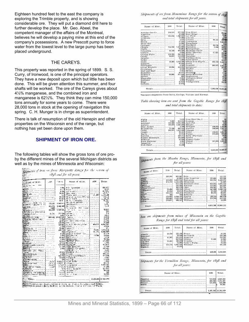
Mines and Mineral Statistics, 1899 – Page 66 of 112
Eighteen hundred feet to the east the company is exploring the Trimble property, and is showing considerable ore. They will put a diamond drill here to further develop the place. Mr. Geo. Abeel, the competent manager of the affairs of the Montreal, believes he will develop a paying mine at this end of the company's possessions. A new Prescott pump to force water from the lowest level to the large pump has been placed underground.
THE CAREYS. This property was reported in the spring of 1899. S. S. Curry, of Ironwood, is one of the principal operators. They have a new deposit upon which but little has been done. This will be given attention this summer, and four shafts will be worked. The ore of the Careys gives about 4½% manganese, and the combined iron and manganese is 62½%. They think they can mine 150,000 tons annually for some years to come. There were 28,000 tons in stock at the opening of navigation this spring. C. H. Munger is in chrrge as superintendent.
There is talk of resumption of the old Henepin and other properties on the Wisconsin end of the range, but nothing has yet been done upon them.
SHIPMENT OF IRON ORE.
The following tables will show the gross tons of ore pro-by the different mines of the several Michigan districts as well as by the mines of Minnesota and Wisconsin:

Mines and Mineral Statistics, 1899 – Page 67 of 112
RECAPITULATION.
For 1899 there promises to be a still larger tonnage sent from the mines of Michigan than for any previous year in the history of the state, The demand for all classes of ore is excellent, and there is fear on the part of furnacemen of a shortage to meet their orders for pig iron. In the shipping of ore from the mines to the principal disnributing centres on Lake Erie a great improvement has taken place within the past five years. The carrying capacity of cars and boats has been greatly increased. Cars now contain from 30 to 45 tons, while the boats take down from 4,000 to 6,500 tons. A few years ago the boat which took 2,000 tons was considered a big one.
The railroads have shown commendable enterprise in caring for this vast business. They have the fiinest ore docks in the world, while their equipment of rolling stock is of the best. A recent innovation is a steel car which is being given a trial and is favorably looked upon. For taking care of the business of the Lake Superior field there are twenty ore docks with a combined capacity of 673,000 gross tons. For the year the Chicago & Northwestesn railway took the lead, sending from its Escanaba docks 2,803,512 tons. For the year there were shipped to local funraces, by all-rail, 374,250 tons. Ore has been sent as far as Alabama by all-rail during the winter months, and experiments are to be made the coming winter in rail shipment of ore to distant points. The main trouble with the winter shipping is due to the freezing of the ore in the cars, steam being necessary to thaw it so it can be readily unloaded. There is from 8% to 15% moisture in the soft ores. Dr. Nelson P. Hulst, general manager for the Oliver Iron Mining Co., is to conduct experiments with a view to drying the ores at the mines. Could this be successfully done it would save the freight charges on about a milion and a half tons of water which are now annually shipped in combination with the ore.
SHIPMENTS FOR 1898 BY PORTS AND ALL-RAIL.
From the Minnesota iron ore fields the distance from mines to lake ports run from 80 to 120 miles. Michigan is fortunate in the location of its mines with reference to lake ports from which the ore is loaded for shipment to the great distributing centers, Chicago, Cleveland, Buffalo, Ashtabula, Erie, Toledo, Lorian, Tonawanda, Conneaut and Fairport.
SAILING DISTANCES.
The following are the distances from the principal iron ore shipping ports to Cleveland, Ohio:
COST OF RAIL HAULAGE OF ORE FOR YEAR 1898.
Since 1894 there has been a reduction in the cost of haulage per ton of 23 cents. The average freight rate for 1898 from lake ports was as follows: Marquette, 60 cents; Escanaba, 40 cents; Ashland, 65 cents.
ORE ON DOCKS.
The following figures show the amount of ore in stock at Lake Erie ports at the close of navigation for the past eight years:
IMPORTS OF IRON ORE.
Imports of iron ore to the United States for the past seven years have been as follows:
Average ore rates for the entire period of twenty years: Escanaba, contract $1.00, wild 96 cents; Marquette, contract

Mines and Mineral Statistics, 1899 – Page 68 of 112
$1.29, wild $1.22. Average for past ten years: Escanaba, contract 78 cents, wild 72½ cents; Marquette, contract 97 cents, wild 90 cents; Ashland and other ports at the head of Lake Superior, contract $1.04½ cents, wild, $1.01.
UNITED STATES PRODUCTION OF IRON ORE.
The world's production of iron ore annually amounts between 52,000,000 and 60,000,000.
PRICE OF IRON ORE.
The price at which standard Bessemer iron ore has sold, delivered at lower lake ports, since 1895 has been as follows:
Since 1890 non-bessemer have ranged all the way from $5.75 to $2.00 per ton, there having been a great falling off in price.
For 1899, while the base ore is fifteen cents higher than in 1898, the price is regulated according to the analysis of ore cargoes for the past season. The following examples will show the variations.
These prices are for the ore delivered at lower lake ports. All ores are sold by sales agents located principally in Cleveland. Ten cents per ton is the price for this service. The increased contract price for 1899 does not make up for the increased cost of labor and supplies. The few who did not make contracts are receiving about 80 cents per ton above figures made last spring.
COPPER.
The state of Michigan is justly proud of its record as a producer of copper. In the list of states it stands second as furnishing this useful metal, while in point of quality it is indisputably at the head. It commands the highest price by reason of its excellence, and “Lake copper” is everywhere recognized as the purest and best.
The copper mining companies of Michigan have distributed and declared dividends amounting to $89,151,875. Of this vast sum $6,900,000 have been already divided or declared for payment in the first half of 1899. At this time the copper mining business is in a most prosperous condition. The demand is in excess of the supply, and the price per pound has risen from an average of 12.1 cents in 1898 to 18½ cents in June, 1899. Never before in the history of the district was so much activity displayed in the searching for new mines, and never before were so many men employed in the industry as now. Due to the great gain in price, and assisted by the general prosperity of the entire country, the past ten months have witnessed a wonderful “boom” in copper stocks. The shares of many new prospects have been traded in at a wonderfully high price, and
Due to the unprecedented, and inflated values, coupled vastly magnified tales of the great fortunes made in the shares, the industry was made the object of unfavorable by representatives in the Michigan legislature who sought pose a specific tax upon the refined product, which, had it been successful of passage, and declared constitutional, would have placed a severe burden upon the mines, amounting annually to about $1,000,000. It was also sought at this time to tax iron ore three cents per ton. I regret that the governor of the state was one of the instigators of the bill, and I believe his object was of a political rather than of an industrial nature. Fortunately, the senate killed the measure after it had successfully passed the house.
While the copper mines have contributed a grand total of dividends, the amount is no more than a reasonable interest upon the selling price of the stocks, running from 4% to 8%, and in reality not enough when the precarious nature of the business is considered. Only fifteen mines have returned money to their shareholders, and of these a single one, the Calumet & Hecla, has paid more than 65% of the total. This is only a small return for the amount which would have to be invested for the purchase of the shares. It must be remembered, too, that the mines are fast growing deeper, and that each year takes much from the supply of rock which makes up the lodes. There can be no replacement of the mineral removed.
While the year 1898 is generally credited with being the banner one in the amount of copper secured, in reality it fell under 1897 by 6,214,383 pounds. The fact that Calumet & Hecla smelted 7,676,680 pounds more during the year than it mined accounts for the credit. For 1898

Mines and Mineral Statistics, 1899 – Page 69 of 112
the production of refined copper was 138,716,287 tons. The Tamarack fell short of its 1897 record by over half a million pounds, the Quincy, was short of its achievement of that year by 570,557 pounds, the Atlantic lacked 732,264 pounds of its return for 1897, the Franklin, 284,682 pounds. The old mines have all been worked vigorously, and the better price for copper which prevailed during the year did not produce any increase in former tonnage. To accomplish this there will have to be improvements in equipment, additional shafts and extended underground territory. This is in progress at the present writing, but it requires time to complete. At all of the principal producing mines there is a constant addition of machinery, shafts and drifts, this being necessary to a successful conducting of the mining business. With the increase in depth of workings heavier hoists have to be installed, compressors of greater capacity must be had to furnish air for the larger number of power drills required, and there is a never-ending outlay to keep the properties in the progressive list and to make them valuable to their owners. The better price for copper now quoted is probably lending a little more force to the development of the older properties, and it is the reason for starting of the newer, but there cannot be any great gain in production for some years to come even if the market conditions now prevailing continue. Of the many new properties being prospected there will be a few good ones which will eventually make mines, but it will require at last three years to place them in shape for production. There are few exceptions to this condition. The shafts must be extended so many levels can be opened and ground selected, for it must be borne in mind that all of the lode does not carry copper in paying quantity. There is much of the rock which will not warrant mining. It would be suicidal to start the mill before the mine could supply rock to keep it busy. Errors of this kind have been made, and they have proved decidedly unpopular.
The copper world need not fear an overwhelming of the market due to the immediate increase from the Michigan fields, because the gain over the present volume of production is going to be slow. It will probably gain a little from year to year, but it is not going to be in such strides as many have thought, and have written about. If it happens that the price of the metal should fall back to the ruling one for the past few years no great gain need be expected in the number of pounds sent to market.
While there has been much reckless speculation indulged in concerning the buying of the shares of the new properties, and while there has been a great depreciation as compared to the purchase price of many of the stocks, the "boom" has not been without its gratifying features. It has called attention of capital to new territory and brought to light several lodes which, while they may be extensions of those worked upon at other points, would not have been noticed but for the recent excitement which provided the money to develop the lands embraced in the many organizations. There has thus been made available a large amount of money which has been set aside as working capital for carrying
on exploring work, and this is going to be attended with success at several points on the range. There is a working fund from $100,000 to $400,000 in many of the new enterprises, and with this a most thorough exploiting of the copper-bearing range will be made from Keweenaw county through to Gogebic county. It is probable that the amount of money put into the district as a whole will be more than will be returned to the investors for many years, due to the exhorbitant prices paid for shares, but that it will develop the region is certain, so that in the long run the industry may compensate for the original cost of the properties.
It has been due to this same mining fever that a new railroad is now being constructed from Houghton southwest to Greenland, which will be of incalculable benefit to the district, and which is expected to be ready for business early in 1900. The same reason suggests a parallel line by the Duluth, South Shore & Atlantic Railway company, which has already surveyed a route and is talking of building a branch of its road through this new and promising field.
Of the immensity of mining operations in the copper region of Michigan the world is already generally familiar. Its deep shafts and wonderfel machinery have been the subject of frequent descriptions, (some of which have been quite as wonderful as the mines and equipments,) so that it would only be repeating what has already been told to give it again. In the mine descriptions which follow will be found accounts of recent additions to the mines which will be of interest to those who desire information on this subject.
Respecting the geology of the district there is nothing new to be presented. The field has already been so thoroughly examined and described that all are well acquainted with it. The conglomerates are old sea beaches, the amygdaloids lava flows, these having been lain down indiscriminately. The deep shafts at Calumet and Hecla and Tamarack cut through forty of these lodes, but few of which hold copper. Then there are the fissure veins upon which work was generally done in the old days in the mines of Keweenaw county. These are at right angles to the strike of the conglomerates and amygdaloids. The latter have a strike conforming to the contour of the Keweenaw peninsula and a dip to the northwest varying from 72° to 25°. Upon Isle Royale, fifty miles out in Lake Superior, there is what is generally conceded to the north rim of this big copper-holding basin. Here the copper-bearing formations dip to the southeast at an angle to the horizon of 12°. All the copper mined is in a native state, the pure metal. No copper ores are found in marketable quantity.
The greatest depth yet reached in mining in the Michigan fields is 4,900 feet below surface, this being at the Red Jacket shaft of the Calumet & Hecla copper mine. At this point the Calumet conglomerate is as full of copper as at any other place in the lode. At a visit in June of 1899 they had cut into the lode from the vertical shaft at 66th level. The rock of the lode where encountered would give about 10% in copper, richer by 25% than the

Mines and Mineral Statistics, 1899 – Page 70 of 112
average of the mine. The temperature at the bottom of this deep shaft is 85° above zero. In other fields it would be impossible to mine to this depth. At 2,000 feet below surface in some districts the temperature would be 150° above zero. The cooler atmosphere is accounted for by the absorption of the heat of the rocks by the waters of Lake Superior, located a few miles distant, and under which the rock stratum of this section extends. As is generally well understood, the water of the lake is little above the freezing point in the hottest months of summer.
Just what the ratio of increase will be as the shafts are extended downward from their present bottom is problematical, but it is thought that a depth of fully 7,000 feet can be reached providing the copper is found to such distance, and there is little doubt but that it will be. Of this point some other commissioner, in some other age, will further explain.
MINES OF ONTONAGON COUNTY. Rockland, which has long slumbered in one of the most beautiful valleys of Michigan, has aroused from its Rip Van Winkle sleep and has taken hold of the business duties of life, apparently refreshed and invigorated by its protracted metalliferous inactivity. With the closing of its mines, which took place many years ago, the people hesitated to seek other fields of employment. There was a charm connected with the spot which attracted and fascinated. Here many of them had been born, and here many of them have since continued to live, true to the soil of their nativity, and earnest advocates always in the future greatness of their home as a producer of mineral wealth.
And one cannot imagine a prettier spot than is Rockland. From the top of the hill above the town a wonderful picture is presented to the beholder. To the west the deep gorge, in which flows the Ontonagon river, is flanked upon either side by rugged hills thickly covered with a wooded growth showing all the wealth of color for which Michigan forests are famous. Upon the western slope can be seen the buildings of the Victoria mine, and the dark smoke rising from the tall stacks amongst the trees; tells of another resurrection.
Twenty miles away the Porcupine mountains are clearly silhouetted against the sky, while to the northwest thirteen miles can be seen, shining like a great bar of polished silver, the waters of "Gitchigumme." Upon the east the lofty hills slope away for several miles to again rise and form the prominent eminence at Caledonia, while to the south abrubt-walled valleys, filled with the babble of waters of innumerable springs, are in turn succeeded by the undulating plains stretching far away. Everywhere the hills and valleys are wooded, and vegetation is of the most luxuriant. One is plainly sensible to the feebleness of the camera or pencil to portray such a scene as this, and the thought presents itself that man would need to do but little where nature
has presented so much to make of this one of the most attractive spots in the great northwest.
Buoyed up by the hope of coming success at the mines, the poulation is exerting itself to meet the improvement which such achievement will bring.
Upon all sides new buildings are in course of construction, many of them being of modern design, and their completing will be of much value to the town. In the list is a brick hotel which is to be heated by steam and lighted by electricity. Owners are asking anywhere from $600 to $1,000 for corner lots, and many strangers are coming in with the idea of profitable investment for their capital and energy.
The opening of new copper mines is a task of far greater proportion than is realized by the novice in such affairs, and those who decide to make their lot in any of the towns of this range must not expect a rapid increase in the population.
In the old days the opening of shafts and drifts was accomplished with hand-hammer and drill, and the old-style Cornish stamps needed but little to keep them supplied. In modern methods it is necessary to open many levels ahead of those from which the daily needs of the mill are cared for.
The giant Balls head now treat 300 tons of rock per day, and where several of them are in motion there must be a large amount of openings from which the rock product is derived. The plan of the mining companies now doing business here will undoubtedly be to get the shafts well down, to open levels, and to be in the best shape for selecting rock underground before the mills are started. This will require two years, probably, and there should be a gradual adding to the working forces at the mines while this is going on.
That the best mines of Ontonagon county have a chance to win a profit one must admit who will give the old properties a careful examination. If the metal remains at its present price there will be no question as to their successful operation. It must be recalled that in the days when the old mines of this district were wrought they were unassisted by the many improvements which have come in more recent years to the aid of the miner. In the old days there were no air compressors, no power drills, no high explosives, no Balls heads, no correct slime tables, no fast hoists, no compounds engines, no power trams and but little system. Ontonagon county was without means for readily transporting its copper or its supplies. There were no railroads, and everything used in the mines was costly beyond reason.
Where the miners used to drift from ten to fifteen feet per month, and small drifts at that, the modern machine cuts through from sixty to eighty feet per month. The bucket which used to hoist from one-half to one ton of rock is supplanted by the skip which takes from three to four tons. The black powder, which was expensive, is replaced by the dynamite of far greater force and is much cheaper per pound for pound than the old

Mines and Mineral Statistics, 1899 – Page 71 of 112
explosive which was employed. The old Cornish mill which used to bet rid of thirty tons per day, has given way to the modern steam stamp which alone treats ten times as much as the old battery.
ON THE ROAD FROM ROCKLAND TO GREENLAND.
And men have learned to better take care of the ground; to better make headway through it, and mining in all its branches has made wonderful strides. This is a progressive age, and since the closing of the old mines of Ontonagon a great deal has been accomplished by those who have continued the business at other places.
If, under the disadvantages I have referred to, there could have been dividends earned in the mines of the Ontonagon range, then it surely is reasonable to argue that with all the improvements which will now be supplied they can make a living. If not, then there cannot be anything in all these inventions and years of experience and study.
There are two copper-bearing belts here locally known as the “North Range" or "Minesota,” and the "South Range" or “Evergreen.” These are about one-half mile apart, the strike being north 67° east, near the east bank of the Ontonagon river, north 35° east at the Mass mines, and north 75° east at the Adventure.
On the north range the lodes given attention were locally known as the Conglomerate and Calico, the Calico being 140 feet north of the Conglomerate.
Upon the south range are five lodes carrying copper. In succession from north to south they are known as the Knowlton, Mass, Butler, Ogima and Evergreen. These would all be cut by a crosscut 800 feet in length.
In the north range were opened the old National, Minnesota, Toltec, Penn, Hazzard, and others, while in the south range were the Knowlton, Ogima, Ridge, Adventure, Belt, Merimac and others. In the recent revival in the copper mining business of this field it was necessary to consolidate many of the old properties in order to make the propositions attractive to mining men and capitalists. More territory was necessary to insure operation upon a huge scale for a long term of years,
and to secure the money needed for a resumption in mining. This has changed the old titles, and to many the new ones will long have an unfamiliar sound.
One of the first to take up the old mines in this section, and the one who has accomplished most up to the present writing, June 1st, '99, is the
MICHIGAN COPPER MINING CO. This company was organized in 1898, and July 15th of that year a start was made to prepare for the future, shafts being located and the work begun. Mr. Samuel Brady, of Detroit, was selected for superintendent, and Mr. J. G. Thomas for mining captain, both of whom are gentlemen well equipped for the positions.
The possessions of the company embrace 4,780 acres of land, the greater portion of which is to the southward of the copper-bearing lodes of this range as thus far developed, but containing a large acerage on the strike and dip of the lodes, nevertheless. The most attractive portion of the property is Sections 15 and 10, the company owning all of the former and the greater portion of the latter.
There is over a mile in length on the strike of the lodes and about the same distance on surface on the dip, which is ample.
Embraced in this tract, and due to which fact the company found an excuse for organizing, is the old Minesota mine, one of the best in the district. It paid $1,920,000 in dividends and this with primitive apparatus for the mining and treatment of rock. The first discovery of copper was made at this property in 1847 by Mr. O. S. Knapp, who was attracted by the pits made by the prehistoric miners, traces of whose work have since been plentifully revealed at every point where there was an outcropping of the copper-bearing lodes. In one of the pits which he cleaned out was found a mass of native copper weighing six tons. The ancient miners had tried to remove this, had lifted it on timbers five feet from the bottom of the pit, when they deserted the task. The timbers which had been placed beneath had decayed, the earth about the mass holding it in place above the pit’s bottom. Growing from the earth which covered the mass was a hemlock tree which showed 395 annual rings of growth, and besides this was a decayed stump of what had once been a much larger tree. Many stone hammers and a copper chisel were found in the pit.
The first copper shipped was in 1848. It weighed 6½ tons for a net price of $1,700. The first dividend was paid in 1852, it amounting to $30,000.
The mine was opened upon what is known as the “conglomerate” vein, but the copper was really held in the trap overlying the conglomerate. In many places where the conglomerate was cracked, copper would be formed, which was also true of the National mine which adjoined immediately upon the west. At the point of contact between the trap and the conglomerate immense masses of copper were frequently found, this

Mines and Mineral Statistics, 1899 – Page 72 of 112
being upon the footwall of the lode proper. At one point between the adit and the 10-fathom level a single piece of copper was found which was 46 feet in length, was 18½ feet at the widest point and its greatest thickness was 12½ feet. The main width was 12½ feet and the main thickness 4½ feet. It took twenty men fifteen months to cut up this mass, and the chips cut from it in the division weighed 27 tons. The entire mass weighed about 500 tons.
Work was prosecuted upon this vein until 1870 when it was discontinued. Copper has since been taken in small quantities by tributers, who worked during the winter months above the adit level and in ground already opened and searched for copper by the former operators. I hear from some of the old miners who were employed there that the lode was rich in the lowest level, while from other sources comes the information that it was poor. It is generally thought that the machinery was inadequate to take care of the mine to a greater depth, the deepest shaft being 1200 feet from the surface, measured on the underlay. It will probably be found that the distance is considerably less. The levels were not often as thick as the fathoms describing them indicated and it is likely that 1,000 feet will find the bottom of the old workings.
In the earlier history of the mine the attention of the company was almost wholly directed to the securing of the mass and barrel work, the stamp rock being given but little attention. This is also true of the other mines in this district. The old stamp mill was a crude affair, and water was scarce. It was slow work securing satisfactory product even with the rock running several per cent copper. There was a trial made with rolls to do the crushing, but this proved a signal failure. The old rolls are still to be seen at the mine, as is an old walking beam engine which Mr. Fred Smith, now superintendent of the Wolverine mine, used to run many years ago.
When the present company took hold of the property they decided to first give attention to the calico lode, 140 feet north of the Minesota lode. It was thought better to go down upon this in solid ground until a point below the bottom of the old workings on the Minesota lode had been reached, and then to crosscut to the Minesota and prove what it held below the old mine. It is believed that the bottom of the mine will prove to be healthy in copper.
Accordingly two shafts were started, A, 1,000 feet east of the company's west property line, and B, 1,000 feet east of A. The former is sunk upon the back of the old No. 4 shaft while B is at the back of the old No. 6. Both are following downward upon the footwall of the lode, if it can be called a footwall, and observe an angle to the north of 46½° to the horizon.
A shaft is three-compartment, is well timbered throughout, and is solid and substantial. It is to a depth of 280 feet. At 200 feet from the collar of the shaft they have started their first level and will open out for the second at 320 feet. The old levels were 60 feet apart, and it is the intention to skip one of these connecting at
every second level. On the east side of the present level they put in a drift which connected with old workings. Here they found considerable stamp rock broken in the level which had not been touched by the former operators who were evidently looking for heavier copper. To the west they have drifted 60 feet. This drift has shown plenty of excellent copper ground, and the shaft has also been productive of exceptionally rich rock. In the burrough piles they have selected the rock, piling the mass and barrel work in one and the stamp in the other.
The selected pile is one of the richest to be seen on the lakes, and the average of both will be high. Near the end of the west drift there is a piece of ground that looks very much like a footwall, but it may prove to be of short length. It is not an easy matter to decide that this is a true vein as many claim it to be. The heaviest copper is generally found on the footwall side of the lode, and the character of the latter entitles it to the distinction of an amygdaloid. On the foot the rock is more compact than towards the hanging, the amygdules being more plentiful on the hanging side. There is epitote seen plentifully, and calcite is frequent. The lode is peculiarly marked with streaks and spots of reddish, brown, yellowish and other hues from which it derives its name.
B shaft is to a depth of 300 feet, at which point will be the second station in this shaft, there being a difference in the elevation of surface at the shafts. It is two-compartment for a portion of the distance and three-compartment at the bottom. The top portion of the shaft will be trimmed down for the other compartment. At this shaft they have drifted 150 feet upon either side of the shaft, east and west, and the character of the lode is most favorable, showing plentifully in copper. One has only to look at the rock pile on surface to be convinced of this. In width the lode runs from five to twelve feet varying in places, as do all amygdaloids. The walls roll considerably in going downward, so that the shaft, which observes a regular angle, is not always in the vein. There is also a slight waving in the formation upon the strike, but this is not of such variation as to cause any difficulty in following the vein. A little experience soon shows the miners where the changes of this sort occur.
The ground is very firm, no timber being needed and there is no water to bother. The stations are roomy, the tracks are three-foot gage, and drifts are carried so there is plenty of space to work in. Everything underground as well as upon surface has been well directed. There are seven power drills at work and more will be added as soon as room can be had for them.
Upon the northeast corner of Section 15 is the old Rockland mine. Within the last few days they have cleaned out one of the old pits here, which has a depth of 60 feet. They found this had been sunk in the hanging wall and by cutting towards the foot a few feet they found the lode and well filled with copper. Specimens showing native silver were also taken from the pit. It seems to be a continuation of the calico lode, the rock being similar to that taken from the shafts sinking to the west. Capt. Thomas is well pleased with

Mines and Mineral Statistics, 1899 – Page 73 of 112
the appearance of this opening. There are none who know the range better than he, and he also understands the opening and running of copper mines.
After a careful inspection of the work thus far done underground one must incline to the belief that the Michigan ought to make a profit with the copper considerably under its present price. Should the ground continue as rich in copper as the shafts show for their present depth there will be no question as to the mine's future. It would be assured.
In addition to the old Minesota and Calico veins the Michigan also has the veins of the South Range which have shown promising ground at several points where recently explored. The Jeffs estate did some work there in the winter of 1897-8, and found stamp rock of healthy character.
There also has been reported an amygdaloid vein lying between the old Minesota and the South Bluff veins. Several of the oldest inhabitants remember having seen it and Mr. Brady has hopes of soon locating it. It is supposed to be only a short distance south from where their engine houses are situated. Some work has already been done in the search for it, and this will soon be resumed.
On the surface there is machinery to care for the needs of the mine for some time to come. The foundation for a new compressor plant is now being prepared at A shaft. There has been a new machine shop constructed which is well equipped with tools, there is a smithy and dry and a new office. At the Rockland end of the mine six double dwelling houses are nearly ready for occupancy. There is a force of 115 men now employed, which number will steadily be increased as the mine can make room for them. The miners are given so much per day and as an inducement to increase the effort a premium is offered for the exceeding of a certain number of feet of sinking or drifting.
Michigan will be well provided for with transportation facilities. The Chicago, Milwaukee & St. Paul road is already within a mile of the location, the Copper Range has surveyed its road to the property, and it is said the Duluth, South Shore & Atlantic is also to build a line to Rockland. It will be a pleasing contrast to the days when the supplies had to be handled by team from Ontonagon.
Just where the mill will be located is not yet given out for publication. First the mine will be developed so a mill can be kept busy.
The main offices of the company are in New York. John Stanton is president; J. W. Hardley, secretary; J. R. Stanton, treasurer. At the mine Samuel Brady is superintendent; J. G. Thomas, mining captain; Wm. P. Miner, clerk; S. H. Brady, supply clerk.
The next active property in going east from Rockland, is that of
THE MASS CONSOLIDATED Mining company, this property now embracing the Mass, Ridge, Merrimac, Ogima and Hazard; the Mass, the northwestern, being three miles west of Rockland. The company has the lodes of the Evergreen range, five in number, and it can follow upon their strike on Mass lands for a distance of a mile and three-fourths.
The first of the old properties to be given attention is the Ridge, located on Section 35, the southwest quarter, Town 1, Range 38. It is an old mine, the first' work having begun in October, 1849. The principal work has been done upon the Evergreen lode, the most southern of the series traversing this district. Upon this three shafts were sunk, the deepest being No. 3, the most westerly on the line, which was to the 7th level, 610 feet from the surface, the angle of inclination being 42°. The latter shaft is the one given attention by the company. I found Captain Richard Trezona full of business getting things in shape, and in his selection the company chose wisely. While they were the last to begin here since the late revival, they have accomplished considerable. The old shaft has been retimbered in many places and is now in condition for the handling of rock. It had been badly treated by the tributers who followed the copper caring not how they interfered with the mine’s future. They probably thought there would be little attention given the property after the close down, which occurred several years ago.
There is a story often repeated in the copper country that the Ridge produced more copper for the fathom of ground broken than any other mine in the Lake Superior region. As to the correctness of this I have no means of determining. To the west of No. 3 shaft there is evidence of a rich territory from surface to the bottom of the shaft. The ground has been beaten out upon this side throughout the entire length of this avenue, and in many places the stopes show a width of more than twenty feet. This is the best sort of indication that the ground here was productive, and backing up this reasoning is fine ground now being shown in the drifts which are being opened up at the 6th and 7th levels west of the shaft. At the 6th level the drift west is in 80 feet, and at the 7th it is in 100 feet. To the east the 6th level drift is in 153 feet, the 7th 100 feet. The fifth is into old workings, and is at present choked up.
To the east of the shaft there is a poor run of ground, and it is the intention to drift through this at the lower levels in the hope of encountering something better. The former operators did but little on this side of the shaft. They found the ground poor and did not contifiue far in that direction, stopping when they had drifted from 50 to 100 feet from the shaft. Capt. Trezona, who is familiar with the peculiarities of copper lodes, is going to push the eastern drifts ahead as far as possible in the hope of showing there is copper on that side of the mine. In three weeks the lower drift has been extended nearly 50 feet.

Mines and Mineral Statistics, 1899 – Page 74 of 112
MINESOTA MINE BEFORE THE LATE BOOM.
To the west of the shaft I went into some of the upper levels and found them badly chocked up with rock which had come down in the time of the idleness of the mine. In the debris could be seen many pieces of rock showing copper, and copper was also frequently seen in the hanging wall of the formation where it had not been touched by the miners who were evidently looking for masses. Much of this was exposed by tributers who worked here after the mine closed.
At a point 80 feet west of No. 3 they will put in a crosscut to strike the Butler lode, and eventually to cut all the lodes of this series. The Butler, where worked upon, gave many fine masses of copper, and in the past few years tributers have taken many masses from it. In the west end of the mine at the second level the lode was particularly rich in mass and barrel work, and it is the desire of the present company to reach this territory as soon as possible. Two shafts were sunk by the former operators upon the Butler lode, these being carried down to the 70-fathom level.
It must be remembered that there was never a power drill in the mine. Five are now running and more will be added as quickly as the necessary machinery can be installed. There was an old stamp mill with twelve Cornish-style heads. In dry weather there was only enough water to run this mill about three hours each day, and two dams were necessary to give even this feeble result. The arrangement of the machinery which was used was bad and the wonder is that the mine did so well. It paid a dividend of $100,000, but this did not equal the assessments.
They will put in a new hoist which will be needed when they begin sinking the shaft. They have a couple of old boilers which have been in use thirty years and are still serviceable. A second-hand compressor provides air for the drills underground.
To the south of the mine a town has been platted under the name of "Mass City." It is about two and a half miles from the location. It is said the Copper Range railway line will pass through it. Several buildings are finished and more are in course of construction.
The Mass mine, included in the company’s possessions, and from which it took its name, is on the southeast quarter of Section 6, and is the western limit of the company’s lands. It is noted for its productiveness in heavy copper, it being particularly rich in masses. It was also prolific in silver, which is true of most of the mines of this range. It is said that the miners made as much money from the sale of silver, when these mines were in operation, as their wages amounted to, and several merchants who made a specialty of purchasing the metal from the miners realized handsome fortunes from such transactions.
The mine was opened in 1856. It worked upon all the lodes traversing the lands, the greater attention having been given to the Evergreen, where six shallow shafts were sunk. The openings upon any of the lodes are not extensive. The bluff here rises to a height of 800 feet above Lake Superior. Immediately south is the Flint Steel river, where the old mill is located.
The Ogima is immediately north of the Mass. It has been idle since 1898. It was worked but little, the product being principally from pits sunk in the outcropping ledge where the prehistoric miner first gave them attention. Seven lodes are known to cross the property. There were two shafts to the third level on the Ogima vein.
North of the Ogima is the Merrimac. Two shafts were started on the Ogima vein and carried down only 80 feet.
The Hazard is on the northeast quarter of Section 1, lying to the north of the Knowlton. But little has ever been done upon it.
The Mass Consolidated is now employing 55 men, which number is to be steadily added to. Richard Trezona is superintendent; E. V. Valmer, engineer; W. A. Brown, clerk. The main offices are in Boston. E. E. Floyd is president; Charles H. Bennett, secretary and treasurer. Thomas F. Cole, Ironwood, is general manager.
ADVENTURE CONSOLIDATED. The third active mine in the Ontonagon district going east from Rockland is the Adventure, the property of the Adventure Mining company, an organization perfected in 1898. The consolidation embraces the Adventure, Knowlton and Hilton mines. The work has been commenced by the new company upon the Adventure, whose location is immediately northeast of the Ridge mine. The lands of the company now embrace all of Section 36 and all but the southwest quarter of Section 35, Town 1, Range 38.
The property contains the Evergreen range series of copper-bearing lodes, and they are giving attention to the most northerly of these, the Knowlton. At the east end of Adventure bluff and just west of Adventure creek they began a shaft several months ago. When the shaft was commenced they thought they would soon reach the solid ledge. The surface sloped gradually to the creek valley, and they supposed the rock followed the
Mines and Mineral Statistics, 1899 – Page 75 of 112
surface slope. Instead of this it made downward sharply, and for a depth of 60 feet the shaft was partly in rock and partly in sand, in this condition of affairs requiring considerable attention from the miners. Timbering was necessary, and much trouble encountered. At 60 feet from surface solid ledge was had, and the shaft is now progressing satisfactorily, being at this writing May 31st, 75 feet below surface.
This shaft is being put down on the Knowlton lode. In the course of preparing for foundations for the machinery which is to be installed at this station, they blasted out a portion of the hill to the south of the shaft, this exposing a lode ten feet wide and full of copper. This is supposed to be the Mass lode, which lies next south of the Knowlton in the series. Nothing has yet been done in exploring this point, but it will be given attention in the near future.
They have the concrete foundations about ready for the machinery, and the latter will be gotten in place as rapidly as possible. There has been much delay in getting the machinery to the mine. It is lying at different points between Pori and Greenland station, and the roads have been so bad during the wet weather that it has been nearly impossible to haul anything of such weight as boilers and compressors over them. Near the site of this shaft an office and shops have been constructed. Not far distant, near Maple Grove, is being laid out a residence location, which is an attractive spot, and one of the prettiest on the range. Foundations for several dwelling houses were being laid at the time of my visit. At a distance of 1,400 feet west of the shaft being sunk at the end of the bluff is located No. 1 shaft, which is also in the Knowlton vein. This shaft, following the dip of the formation, is to a depth of 190 feet. At 75 feet from surface there is a drift going east which Is in 80 feet. From the bottom of the shaft drifts have been extended east and west 150 feet, which comprises the amount of opening at this point.
The lower drift east of the shaft shows finely in heavy copper. It is certainly a healthy looking lode at this point, and will equal the best the district now has to present. Copper in healthy quantity is also to be seen in the drift going west.
This shaft is 1,000 feet east of the west boundary line of the Mass Consolidated, and of the portion formerly known as the Ridge. In all the distance from No. 2 shaft to the Mass line, 2,400 feet, there has been an exposing of the lode upon surface. The original openings were made by the ancient miners, and more recently by the tributers. Tributers have attacked the lode at many points along its strike and followed downward until water level was encountered when they were forced to desist. From this stretch of ground much copper in the shape of mass and barrel work was obtained, Of course the tributers could not do anything with the stamp rock. The old company which began mining here in 1850, secured the most of its copper from tributers. It offered so much per ton, or portions of tons, but active mining of this character was stopped in 1887. Since then tributers
have worked here during the winter months, but few men being employed. Several large masses were secured during the winter recently ended.
It is the intention to sink a shaft midway between Nos. 1 and 2, starting in one of the old pits which has shown well in copper so far as it has been worked out.
The copper is said to occur in bunches, and it is also reported that the veins are not well defined, but there has really been little done to determine this. I find all the copper-bearing lodes to hold the metal very irregularly. Some places will be found very rich and others practically barren. The strike of the lodes seems to be regular, and there is no trouble following them. The work thus far done by the company has been attended with much success, considerable copper having been shown. It is true that but little has yet been done, this being unavoidable due to the trouble had with getting the machinery to the mine.
The old maps show an adit driven from the north side of the bluff to intersect the lodes, several hundred feet of drifting, and shaft sinking, but little depth was gained, and I am of the opinion that the records show much more work done than was ever accomplished. The shafts do not prove to be as deep at any of the old mines as the records indicate.
It is the intention to put in a crosscut from No. 1 shaft on the Knowlton vein to the Butler vein, which is 400 feet south, and which has been productive of fine ground at other points.
The old Hilton, which occupies the southeast corner of Section 36, has been idle since 1865. Two shafts were sunk 100 feet, and a little drifting done.
The Knowlton, which was located in the southwest quarter of Section 1, Town 50, Range 39, worked upon the Knowlton vein. Its shafts did not reach a greater depth than 240 feet on the underlay. Mining was discontinued by the company in 1866, since when it was worked at times on tribute, and under many disadvantages.
The company has plenty of territory on both the dip and strike of the lodes which cross their lands. These lodes run all the way from four to fifteen feet wide, and with several shafts down and plenty of levels to make proper rock selection from, the company ought to make a good showing.
It will take a little time to accomplish this, as copper mines are not made big producers in a few months.
B. F. Chynoweth, Rockland, is superintendent. He is well versed in the formations of this section, and is valuable to the company. Thos. Trevarrow, who has been active in this field for many years, is the captain; Capt. Samuel Harris, of the Quincy mine, Hancock, noted as one of the best, is general manager. The main office is in New York. Thos. F. Mason is president; Wm. R. Todd, secretary and treasurer.
Mines and Mineral Statistics, 1899 – Page 76 of 112
The mine is now employing about 50 men. At No. 1 shaft they are cutting away the second growth of timber about the location and cleaning up the surface to prevent accident from fire.
The only other active copper property in Ontonagon county at this time is
THE VICTORIA MINE. The property of the Victoria Copper Mining company, a recent organization which was formed to work the lodes to be found upon several old properties to the west of the Ontonagon river, and four miles west of Rockland.
The Victoria mine, where work is now in progress, was formerly known as the Forest, which began mining in 1860. There was considerable done on surface, a stamp mill being built using the old-style Cornish heads, of course. This was afterwards destroyed by fire, and following that a tremendous freshet swept away much of the surface improvements. A shaft was sunk 150 feet and several fine masses of copper were obtained, one weighing 1,860 pounds. The lode upon which the work was done is supposed to be the Evergreen, as it lies at the propper distance from the south conglomerate, which runs through this section, to be identified as such.
They now have the water nearly out of the mine and are cleaning out the old rubbish and mud which will require a little time to complete. After that there will be a chance to get a look at the lode. The superintendent, Capt. Thos. Hooper, has done excellent work here in getting a start. The machinery had all to be taken across the river, and he put forth every effort to get it upon the location before the break-up so that the river could be crossed. There is no bridge, and one has to cross upon a scow. The last piece of heavy machinery was gotten over the ice just the day before the break-up came. It is the intention to construct a bridge across the stream. The river here has a rapid fall, and the water power which can be utilized should be valuable in providing power to run the mine. There is abundance for other mines in this section, electric power being readily conveyed.
The company has 2,300 acres and embraces many old mines which were originally set off form the lands of the old Forest company, these being known as the Glenn, Shirly, Oneida, Sylvan, Devon, etc.
This field is one of which but little is known. The work done in the old days was imperfect, and the failure of the old properties is no proof that the district does not possess merit. The developments at the Victoria will be eagerly watched.
The main office is in New York. John Stanton is president; J. W. Hardley, secretary; J. R. Stanton, treasurer.
THE ARCTIC COPPER MINING CO. This is an organization which was perfected in the spring of 1899. It owns 1,992 acres of land, which is well located on the mineral belt of this district and holds all seven of the lodes which have been given attention. The property is better known under the title of “The Belt Copper Mines, Limited,” under which name it was given considerable attention some years ago, the money being provided by English capitalists. The mine, known as the Belt, was located on the northwest quarter of Section 1, 37-51, and a mile east of the old Hilton mine. There was an elaborate equipping of the surface. A railroad was constructed, a mill building erected and equipped with the best machinery and everything was placed in the best of shape upon surface. All this was done before the mine had been opened, and was a great mistake. When the mill was ready the rock to keep it busy was lacking. It was a great disappointment to the shareholders, and the property was active only a short time after the work in the mine was fairly commenced. In its active period the property now controlled by the company produced 500 tons of copper. There are dwelling houses, machinery, shops, etc., and everything can soon be placed in shape for active operation. I believe the new company intends commencing work at once.
Mr. Alfred Meads, who has long been a resident director of the company, is prominent in the enterprise, and has excellent men associated with him. Among them are Hon. Don M. Dickinson, Detroit; Hon. T. B. Dunstan, Hancock; Dr. W. Seward Webb, president of the Palace Car Co., New York; Col. A. B. Chandler, president of the Postal Telegraph Cable Co., Fred H. Williams, Sydney Harwood and O. E. Weller, all of Boston.
There were two shafts sunk. One was to the third and the other to the 4th level, and from these about 400 feet of ground was opened to the west by drifts.
THE NORWICH. The next active property in going southwest from the Victoria, following the trend of the copper range, is the Norwich. Here there are a few men employed under the direction of Alfred Meads, of Marquette, who is getting the property in shape for re-organization. Associated with him are several gentlemen of Ironwood, Mich., among whom are S. S. Curry and A. D. Garner. The old mine is located upon Section 1, Town 49, Range 50. Work was first done here in the fifties. The lode outcropped upon the hillside, and a tunnel was driven to it from the bottom of the hill, the most of the work done being from this adit. In 1863 the Windsor, which adjoins, was added to the Norwich. The Norwich produced 496 tons, 1,360 pounds of copper. The Windsor mined 34 tons. There was $230,000 expended upon the property in the time of its activity.
Ironwood, Mich., parties are also endeavoring to place the Hamilton property, which consists of a large tract of land lying immediately north of the Norwich. Mr. A. D. Garner has the interests of a pool in charge.

Mines and Mineral Statistics, 1899 – Page 77 of 112
THE OHIO TRAP ROCK Adjoins the Norwich, and was worked for only two years in the early history of this section, producing 20 tons, 1,125 pounds of copper. The property originally consisted of 3,316 acres, but 1,614 were afterwards disposed of to the Collins Mining company.
In this district are many old prospects upon which but little was done. There are the Hudson, Pittsburg, Clifton, Sharon, Cascade, Clinton, Derby and Eureka.
Near Gogebic Lake the Forest Sheppard company did some work in 1864, it holding 2,366 acres, finding nothing of value. The Waukulla Mining company, owning 480 acres in Sections 19 and 20, Town 49, Range 42, did some costeaning near the lake in trap rock, striking nothing of value. There are old pits to be plentifully seen in this section.
IN PORCUPINE MOUNTAINS. This is one of the interesting points in Ontonagon county. The “mountainous” district extends inland from the shore of Lake Superior for a distance of eight miles. Two ranges of hills are formed with the Carp river flowing between. The district covers Ranges 42, 43 and 44. Some of the hills rise to a height of 1,200 feet above the lake.
THE CARP LAKE MINING COMPANY Was one of the first to give attention to this field, being organized in 1858, mining being conducted in a spasmodic manner for several years. The copper produced amounted to only 15 tons, 1,135 pounds, the work being done upon Section 15 Town 51, Range 43, on the north side of the north range of hills and about half a mile from Lake Superior. A resumption took place in 1897 when a shaft was started upon the south side of the bluff. A shaft was carried down 30 feet in an altered sandstone in which the copper here is found. The dip of the formation is to the north at 26%. The copper-bearing sandstone is three feet thick. Work was stopped in the winter of ’97, and was resumed in a small way the following year. They have cleaned out the adit of the old workings and are trying to interest capital in the operation of the property. M. G. Waterson and N. P. McLean, of Cleveland, Ohio, are interested.
THE HALLIWELL COPPER COMPANY Has been doing a little work in Sections 27 and 28, Town 51, Range 42, the past two years. A plant of machinery has been placed in position, and three small exploring shafts were carried down a short distance. The copper is in the sandstone and is very fine-grained.
There has been considerable testpitting done in this vicinity but nothing of value discovered. B. Schatzinger is president; Charles W. Voth, secretary, both of Cleveland, Ohio.
THE NONESUCH MINE, Which is located at the southeast end of this mountain range, on Section 12, Town 50, Range 43, has been idle many years. There was a fine plant of machinery, but the copper was too fine to be saved. There was copper enough in the rock could it be caught in the mill. Tests are now being made by Chicago parties who believe they can save the copper. During the time the property was worked it spent $400,000 and produced 180 tons, 1,072 pounds of copper. Four shafts were sunk, the deepest being 350 feet. The lode averages seven feet thick.
There is the Muscowaubic, adjoining the Carp Lake in Town 51, Range 43, which showed nothing of value. Many old properties long since abandoned were in this field, and may be given attention in time to come.
MINES OF HOUGHTON COUNTY. Going northward from the mines of Ontonagon county, the first active property met with is
THE WINONA MINE. The Winona property has long been looked upon with considerable favor by many of the mining men of Michigan’s copper region. Copper was discovered there in the early sixties, at which time a little work was done in trying to prove the richness of the lodes. The metal was sufficiently abundant in the rock to encourage the belief that it would prove profitable to mine, but there was the drawback in not having a railway nearer than Houghton, which point was twenty-six miles distant. It would not be feasible to haul the rock out by teams, and the property was abandoned in 1864, remaining idle until May, 1898, when a resumption took place, option having been secured by the brokerage firm of Payne, Webber & Co., of Boston, who placed a few men at work. Following this preliminary trial the Winona Copper company was organized last November, since which time the development of the property has been going forward in a careful, systematic manner. The landed possessions of the company consists of 1,480 acres located in Sections 19, 20, 29 and 32, Town 56, Range 32, and there is a length of lode on the strike of the mine, providing the copper-bearing belt crosses the entire stretch of the property, of over a mile. Thus far the company has proved its principal lode for a distance of 2,700 feet, this being done by two shafts and a number of pits. Copper has been found in the shafts and in all pits with the exception of one, being put down at the northern end of the line of exploring work. This has the footwall of the lode and copper is looked for soon.
The lode being given attention is an amygdaloid. It has been said that there were three lodes carrying copper which ran through the property, an amygdaloid, a conglomerate and an epidote. The latter has been described as the best, but thus far the present company

Mines and Mineral Statistics, 1899 – Page 78 of 112
has failed to located it, and it is now believed that such a lode was never found here. The conglomerate outcrops plainly at several points, but it shows no copper. But little has been done to prove its value, however. It lies east of the amygdaloid, being not unlike the conglomerate found at the Baltic mine. In this connection it is interesting, and there are those who contend these lodes are identical with those of the Baltic, notwithstanding the fact that the Baltic workings are 20 miles to the northeast. Should this prove correct it would show a wonderful persistency of formations and suggest a very rich territory between these two interesting points.
The shafts which have been started are three compartment, 7x19 feet, inside of the timbers, and are substantial and well planned.
No. 1 shaft is located near the center of the northeast quarter of the northwest quarter of Section 29, and about 2,300 feet, following the strike of the lode, from the west line of the section. It has reached a depth of 225 feet, and two levels have been started. At the first they are 90 feet north and 60 feet south of the shaft. At the second the drift is extended 100 feet north and 100 feet south of the shaft. At the first level, just south of the shaft there is a crosscut 20 feet, which shows a width of lode 16 feet, and 60 feet north of the shaft at the second level a crosscut shows the lode to be 33 feet wide. This is the extent of the openings at the shaft. The rock has all been placed in one pile as it has come from the shafts and drifts, there having been no selection. They were about to begin a poor dump at the time of my visit, so that the waste would no longer be mixed with the stamp grades and have to be sent to the mill when a mill has been provided. The drifts showed some healthy lode and some rather poor in copper. The rock has a good appearance, is reasonably soft, and carries calcite, quartz, epidote, etc. Copper was generally seen close to the quartz and the epidote carried it in many places. One of the best pieces of ground so far met with is in the crosscut at the second level where the lode shows such great width. Sinking was resumed in this shaft May, 24th.
The dip of the lode here is 72 % to the northwest, being similar to the inclination of the Baltic lode. It is certainly a persistent, strong belt, and can furnish an immense amount of rock. As to what the percentage of copper will be, that remains for the mill to determine. It is not easy to decide this question by handling the rock, or by inspecting it. Much of the copper is very fine, but it is of granular formation and would be saved in the mill. There were no flaky pieces to be seen which might be lost in the tailings.
Enough has not yet been done to prove the value of the lode, or to warrant the erection of the mill. There will have to be a deepening of the shafts and an extension of present and future levels before Winona can be said to be a paying property. There certainly is much to be seen, however, to warrant the active prosecution of exploring work, and this is what the company is going. They are anxious to find out if a mill is needed. and to
begin the construction of one at the earliest possible moment when the mine gives a reason for such an outlay.
THE WINONA MINE.
No. 2 shaft is located 900 feet south of No. 1. It is 175 feet deep, and the first level has just been started. The lode at this shaft is similar to that at No. 1.
South of No. 2 shaft about 300 feet is No. 1 pit, and still further south 325 feet is pit No. 2. 900 feet north of No. 1 shaft is pit No. 3, and 500 feet north of this pit is No. 4. Other pits are being sunk to the south of No. 2 pit. It is the intention to prove the lode across the entire property, and then to locate other shafts at the best points.
The securing of supplies has been tedious owing to the long haul necessary. Teams having toted the material, machinery, etc., from Greenland, on the Chicago, Milwaukee & St. Paul road, sixteen miles distant, and excellent headway has been made when the difficulties are taken into consideration. Substantial shaft houses have been erected at the shafts, the framing being completed. Between the shafts there is a boiler house and engine house. The former is 40x48 feet, the latter 40x40 feet. Both are steel framed and covered with corrugated iron, being practically fireproof. There are four 80 horse-power boilers all set in place, a two-stage Ingersoll-Sargent compressor with a capacity for driving twelve No. 3 drills, two 5-foot drums holding 700 feet of rope. Similar hoists will be provided for each shaft. Only one is now in place. There is an old compressor which has four-drill capacity. A little hoist at No. 3 shaft will be placed underground.
There are the necessary shops, a neat office, a fine camp and barn. Much has also been done in the way of clearing away the timber and underbrush which thickly covered the surface of the location. This prevents danger from forest fires. A short distance southeast of the mine they have platted a town site and here will be constructed fifteen double dwelling houses the present summer. There will also be two large boarding houses put up as well as residences for the local officers of the
Mines and Mineral Statistics, 1899 – Page 79 of 112
company. The site is a pleasent one. There is excellent chance for drainage, the Winona, like most other copper mines, occupying an elevation considerably above the surrounding country.
A sawmill is one of the convenient possessions of the company. It is located to the south of the line of shafts upon a small creek, and has been a great help in furnishing timber for the mine. A shingle machine will also soon be added, one having been secured with the mill. It was all cheaply bought from a concern that was going out of the lumber business.
Owing to its being so far from the principal towns of the range it has not been an easy matter to secure labor. Soon there will be a railroad, and a telephone line is already under way. The Copper Range railway main line will run within 1,500 feet of the mine, and it is expected it will be completed to this point the present year.
A force of 110 men is employed, and all mine work is done on the contract system. The local officers are: Superintendent, F. W. Denton; clerk, W. VanOrden; mining captain, John Welton. The main offices are in New York. President, John Stanton; secretary, J. W. Hardley; treasurer, John R. Stanton.
The company had as an exploring and development fund $250,000 when it began business last year.
THE WYANDOT. This property lies immediately north and east of the Winona. It is looking for the Winona lode, and ought to find it. It has territory which should carry the Winona copper-bearing belt for a distance of over a mile and a half. It has 1,040 acres of land. It owns the south half of Section 16, the east half of the southeast quarter of Section 20, Section 21, 52-36.
At the time of a recent visit they were opening in ledge which looked much like the wall rock of the Winona lode, and they will undoubtedly soon encounter the object sought. They are getting camps in shape, will erect several houses, and endeavor to find a mine with the $300,000 which have been set aside for that purpose. Twenty men are being employed. The work is being done at a point about a half mile north of the north shaft of the Winona company.
Wm. VanOrden, Houghton, is looking after the work. The main office is at Boston. President, Henry Stackpole;secretary and treasurer, W. O. Gay.
THE KAUKANA. This property is to embrace Sections 9 and 10 north of the Wyandot providing the promoters can arrange for its satisfactory placing. This is now being attempted, options on the lands having been secured by Skiff Sheldon, of Houghton. The tract is in line with the strike of the Winona lode, and copper was found years ago on the lands of the Everett and Shawmut which are to be embraced in the organization, providing one is made.
THE ELM RIVER Copper Mining company is one of the latest to begin operations on the South Range. It owns 2,500 acres located north of the proposed Kaukana, embracing the Hussey-Howe tract and is one of the Fay group of properties. The company has a stretch of two and one-half miles on the strike of the formation and claim the Winona lode for the entire distance across their lands.
Work was started here in May, 1899. Comfortable camps have been built and a force of 125 men is now employed. Five pits are under way, and machinery is now being hauled in. It is intended to turn the pits into shafts in case copper is found. At the most southerly opening copper has been struck and they are preparing to follow the lode with a three-compartment shaft. The lode being given attention is an amygdaloid. Two conglomerate belts have been located but show no copper. They serve to locate the principal lode, however. Other amygdaloids have been encountered, one of which is said to cross the old Shawmut property.
The local officers are James Chynoweth, superintendent; William Uren, assistant. The main offices are in Boston, the officers being the same as those of Centennial.
The company has a working capital of $600,000.
The next active property in going north from the Wyandot is
THE COPPER RANGE, Which is exploring on Section 31, Town 45, Range 35. The Copper Range Mining and Development company is a part of the Copper Range Railway company, which was organized in January, 1899 for the purpose of building a railway between Houghton and Greenland and to develop the mineral lands acquired by reason of its completing this grand improvement. A railroad will be of vast importance to this mineral-bearing district and the lack of one has been the principal drawback in the development of the territory lying between Houghton and Rockland, a distance of about fifty miles.
The work of building this new line is already well under way. The right-of-way has been cut out, camps have established and grading and filling is being prosecuted with vigor. It is the intention to have the road ready for the rolling stock at the close of the present year. The company has $1,000,000 in its treasury, and will apply a quarter of this towards the development of the most prominent of its mineral lands.
The district besides being a valuable one in mineral is also finely timbered with hardwood and the soil is generally fertile and would bear excellent crops.
The officers of the railroad company are: President, James H. Seagar; vice president, William A. Payne; secretary and treasurer, Fred Stanwood.
Mines and Mineral Statistics, 1899 – Page 80 of 112
The local representatives are C. A. Wright, Houghton, general manager; Thomas Appleton, chief engineer.
The company has about 11,000 acres of land well located in the mineral belt, and have begun the exploring of those located south of Tri-Mountain and Baltic. On the section above referred to they have recently exposed one of the finest showings of copper to be seen in the new explorations of the copper district. An amygdaloid has been located which has a width of 30 feet and is filled with copper, mass, barrel and stamp. This find was made in June, 1899, since which time nothing has been done upon it. The lode was covered with but a few feet of drift, and the work thus far done has been to trench across the top of the lode where the latter outcrops. One of the reasons for not continuing operations here was that the officers of the company were soon expected to pay the district a visit and it was desired to let them see the rich copper in the lode.
The work here is under the direction of Dr. Hubbard, late state geologist of Michigan. Operations were commenced in the northwest quarter of the northeast quarter of Section 31.
The first lode located was an amygdaloid showing a few specks of copper, but was not valuable. From this pit they went east 400 feet, and here encountered the amygdaloid upon which the rich discovery was made. Further east 800 feet is a big belt of conglomerate which shows no copper.
The find of copper here looks well for the future of this district and suggests that the new railroad will have something to repay it for the expense of building through this section. The company has a block of seventeen sections located between Baltic and Kaukana, and it is a most promising territory. A force of 25 men is being employed.
The officers of the mining branch of the enterprise are Wm. A. Payne, president; Fred Stanwood, secretary and treasurer; Dr. L. L. Hubbard, general manager.
THE TRI-MOUNTAIN. The Tri-Mountain Copper company has an attractive location immediately between Baltic upon the north and Copper Range upon the south. Excellent showings are being made by both of its neighbors, and it will be surprising if it will not eventually find the extension of the Baltic and Copper Range lodes. It is yet too early in the history of recent developments on this range to say that the Baltic and Copper Range lodes now being given attention are identical. If they are then the formation maks a very sudden turning to the south after leaving Baltic lands.
Tri-Mountain first began work in the southwest quarter of the southwest quarter of Section 20, hoping to find the Baltic vein. A shaft was started in sand and was finally stopped after a depth of 90 feet had been reached. The ledge was not struck. This sand shaft has been
timbered securely and they can resume sinking her in case they wish to do so.
After operations ceased at the sand shaft they went a half mile southeast and started a trench which found an amygdaloid lode in 50 feet from where the trench was begun. The location is about one-half mile from where the rich find has been made on Copper Range. It has rock of the same character. No copper is seen in it. Believing this to agree with the Copper Range formation they have measured off 400 feet to the east and have started two pits to find the rich lode of their neighbor. They also have a diamond drill working a short distance west, but too far away to prove the lode they are now sinking for. It will test considerable ground to the west, however.
Where the first lode was encountered at this latter point where the company is now working, there was only 15 feet of sand covering the ledge, but going eastward the drift grows heavier rapidly, and they are meeting with sand which bothers sinking work greatly. They hope the overlying burden will not be as heavy here as in the first shaft put down in the task of finding the ledge. It has been a very discouraging business.
They have a 10-ton boiler on the ground, a neat hoist and compresser, which are being placed in position. They have a fine set of camps for the men and have dwelling houses. Roads have been constructed, and much surface work done. A force of 125 men is engaged.
Tri Mountain enjoys a fine position for the finding of the Baltic and Copper Range lodes, and it also hopes to find extension of the Isle Royale mine lode.
The company has a working capltal of $400,000, which is ample to explore and equip the property. The latter is under the Fay management with Jas. Chynoweth in local
THE BALTIC MINE. The mineral district lyiug south of Houghton and between this village and the Winona mine, 26 miles distant, depends greatly upon its immediate future to the accomplishments of the Baltic mining company. Should the Baltic fail to give a profitable yield of copper in the stamp mill it will certainly have a most depressing effect upon Tri Mountain, Copper Range and other concerns which have been stocked for the conducting of the copper mining business and which lie to the south and west of Baltic territory. It has been principally due to the developments at the Baltic mine that these adjoining properties have been purchased by speculators at a high price and companies organized for their development. It was due to the showing here that the new railroad, Copper Range, recieved its most forceful impetus and brought about successful organization. It was the attraction from which much has sprung, and, as I say, its immediate future will have no little influence upon the lands in that vicinity in the minds of the speculating public.

Mines and Mineral Statistics, 1899 – Page 81 of 112
I paid the property a visit May 15th, going through every shaft and every drift in the mine. It is fair to designate the property as a “mine,” it having grown beyond the stage of a “prospect.” I was agreeably surprised in what has been developed since last fall, when I last inspected it. It has been much improved both above and below surface, and the most gratifying change is underground. Should Baltic continue to show such rich ground as is to be seen generally in the lowest level, it can make money, and plenty of it, with a much lower price for copper than is now being quoted.
Baltic is a lode new to the mining men of the upper peninsula. It differs in position, size and characteristics of formation to all other copper-bearing belts. Is was by reason of these peculiarities that those who first worked it had doubts of its value. Its permanence was questioned, and when a test shaft, sunk at an angle of about 55%, (the usual inclination of lodes in this section), quickly passed out of the belt into trap rock, its future was not considered of sufficient importance to attract further attention. Had those who did the initial work here known that the lode observed a dip of 72% to the horizon instead of 55, the looked-for angle in this section, the Baltic might have been known more about years ago, but this was not discovered until Captain W. A. Dunn, of Houghton, took hold of the property in the summer of 1897. There was at this time many tons of mass copper upon the old dump which had been mined from the 90-foot shaft in 1883. He believed all that copper did not come from a mere pocket in the formation, and he proceeded to prove the correctness of his theory.
He soon discovered that the former operators had not followed downward upon the lode, but had left it and gone into the hanging. It was not difficult to do this, as the lode at this point and in the upper portion of the shaft, was of trappy appearance. Captain Dunn continued his exploring here until December, 1897, when a company was formed under the title above given, its management being the same as that of the Atlantic, Wolverine and Mohawk, which is everywhere looked upon as conservative and reliable.
Since this time the company has made commendable headway. No. 1 shaft, located a the present most southern end of the property, and the continuation of the old one where the lode was first revealed, was straightened out conforming to the dip of the lode, and occupying a position on the footwall, has been continued to the third level, a distance below surface of 225 feet. When the second level was reached the bottom of the shaft looked so well they decided to continue downward, and have ended at this point. No further sinking will be done here. If other shafts are sunk in this end of the property they will be located further south. They have drifted south of the shaft on the different levels and find good lode, the breast of the lowest drift being in excellent ground at the time of my visit. They are also beginning to do some stoping about this shaft. The lode has a thickness of from 50 to 60 feet at this point, being
the biggest in this respect of any of the working lodes in this district.
No. 3 shaft is located 635 feet to the north of No. 1. It is a fine three-compartment shaft, and they are now opening up the third level. This will be one of the most active shafts on the property as here is located the shaft and rock houses, the machinery, and the crushing of rock will for some time be done here.
No. 3 is connected at the second level with No. 1. On this level they have also drifted north 400 feet and are north on the 3rd level 100 feet. It is at this point where I saw remarkably rich rock, stamp rock and barrel work in wonderful quantity. It is showing for nearly all the 100 feet from the shaft and is the full width of the drift, from ten to twelve feet. In the opening of drifts upon the different levels they are following the footwall, and are doing no crosscutting to determine the width of the lode. The hanging side shows plentifully in copper in this drift and how far it will carry the rich copper ground is not known. It is certainly showing a fine amount of it and it would be a most satisfactory quantity were it to be no bigger than at present. It already averages as wide as most of the best mines in the district. I took specimens from this drift which are as rich in stamp rock as can be found anywhere. No. 3 is a three-compartment shaft as are all the permanent shafts upon the property.
No. 4 shaft, located 900 feet south of No. 3, is to the 3rd level. On the second level they have drifted on the foot in their opening of the level, 340 feet south and 150 feet north. On the 3rd level they are 60 feet north and 60 feet south. This work has been accompanied by the most flattering results. The lode is full of copper, this being particularly true of the deepest workings.
No. 5 shaft is 805 feet north of No. 4 and is also to the 3rd level. On this level they have drifted 50 feet each side of the shaft, north and south and copper is showing in healthy quantity. It is in the bottom of the shaft, however, where the richest ground is to be seen. This is exceptionally fine and will fully equal the big showing in the bottom of No. 3. The miners were doing much grumbling because of the hard drilling, this being occasioned by the copper being so plentiful in the rock. It certainly looks well for the future of the mine. No. 6 is about 400 feet north of No. 5, and is 70 feet deep, finding the ledge and copper, but they are doing nothing upon it, having all they can attend to at other points. They are getting the shafts down as rapidly as possible and opening up levels so as to be in shape to supply a mill when one is ready. A test of the rock is being made in the Atlantic mill at this time, July, ’99. It is said to be showing nearly 2% in copper. The richest rock does not come to surface, it being stored in the mine. I saw a great deal of very fine stamp rock, mass and barrel work in the levels. This will probably be used to regulate the monthly product after the practice of other mines which have such reserves to draw from and thus bring the monthly output to a certain point. The Baltic, like all other mines, has its poor stretches of ground. I visit none which do not have them, but the average of the
Mines and Mineral Statistics, 1899 – Page 82 of 112
bottom of the mine is excellent. It will be surprising if the mill does not show 1½% and if the good ground now being cut holds out it will do much better than this.
There is probably on surface at the different shafts about 35,000 tons of rock, much of which will go to the mill. Everywhere on this stretch of opening the dip of the footwall is the same, about 72°. There are places where the foot benches out into the lode, but the dip is not changed by this. By reason of this “stepping” out of the foot the shafts are sometimes back of the lode, and the latter has to be reached by cutting out to the northwest a few feet, but it is not difficult finding it. These steps or benches of ground are also met with in following the footwall with the drifts, the breast of the drifts coming up against the footwall trap. In these cases the miners turn the drift slightly to one side and soon find the lode again.
In going from south to north on the line of shafts the land inclines to the north, so that the corresponding level at 225 feet in No. 1 shaft is found at 190 feet in No. 5. This is the reason that the levels in the shaft to the north are referred to as the third whereas they are really the second from the collar of shafts.
A subject which has received no little attention is the extension of Baltic lode on the extreme north end of the property. As is generally known the Atlantic Mining company is conducting explorations near the southeast corner of its Section 16, the object being to find Baltic lode upon Atlantic lands. It was originally thought that the strike of the Baltic mine would bring the lode very near the corner of the section. A shaft was sunk feet close to Baltic line upon Atlantic lands and from the bottom of this shaft a drift was started south to find the lode. At a distance of about 950 feet on Baltic territory from Atlantic’s copper was found, but the rock carrying it had little thickness. They drifted with its trend and it soon gave out, nor did it show above the drift. The rock was finely charged with copper. This drift is running under a swamp, and they cannot be more than 20 feet of ledge over the miners’ heads, if that much. The ground is badly broken, being so near surface, and they are finding some water. They are continuing the drift across the formation, being now in about 1,000 feet. At a distance of 140 feet east of the Baltic amygdaloid there is a belt of conglomerate from 14 to 16 feet thick and the exploring drift will be pushed ahead until this is encountered. This would be a guide to show them where they are. I find many who believe the Baltic vein was cut long ago in this drift, and that by reason of its nearness to surface it was so badly broken and decomposed as to be undistinguishable, but this is merely rumor. There is a slight bending of the formation between Nos. 4 and 5 shafts, Baltic, No. 5 showing the lode to be 25 feet east of No. 4 in a distance of 850 feet. From this point north, if the Baltic lode has not been encountered in the Atlantic crosscut, there must be a decided bending of the formation or a big faulting. The distance from No. 5 is about 1800 feet. If the lode has not yet been found, and if it should be encountered at a still greater distance away from Atlantic’s boundary it will
be of little use to the latter. It would require a very deep shaft to reach it upon its underlay, the lode standing so upright. It would be far more valuable to Baltic than to Atlantic unless there was a consolidation of the properties, which is not unlikely at some time in the future.
The sinking at the several shafts is being done with kibbles, these traveling on wire cable guides attached at the lower end to the hanging wall of the shaft. The No. 3 shaft skip tracks are being placed in position, and everything will soon be ready for the hoisting of rock for the mill at this point.
The No. 3 shaft house and rock house is equipped with four crushers, the necessary engines to operate them are in place, and the reduction of rock can begin at any time. The mine now has two air compressors, a new one having been recently installed. It has a capacity for furnishing power for 13 No. 3 drills. There are thirteen drills now being worked in the mine, and more will soon be added.
There has been a great change upon surface within the past six months. There are now thirty-one fine dwelling houses, roads have been made about the location, the timber cut away, and a railroad connects with the Atlantic mine, Captain Thos. Rowland, who has charge of affairs in and about the mine, has done excellent work for the company.
There is talk of an assessment, as the last financial state ment of the company suggests one ought to be nearly due. The following is the record of receipts and expenditures according to the report presented to shareholders January 1st, 1898:
The 27 tons of barrel work which were smelted gave 80.16 % in ingot.
The company possesses 800 acres of land, comprising the east half of Section 20 and all but the southeast quarter of Section 21, Town 54, Range 34. This gives over a mile and a half upon the strike of lode, and they can follow it upon its dip as far as it is practical to conduct mining. Baltic has a fine territory, and at this writing has a very bright showing.
The company is employing 100 men. The main office is in New York, John Stanton being president; John R. Stanton, secretary and treasurer. Cameron Currie, of Detroit, is a director. F. McM. Stanton, Atlantic mine, is superintendent; A. D. Edwards, clerk.
Mines and Mineral Statistics, 1899 – Page 83 of 112
MINERS COPPER COMPANY. This is a recent organization formed to explore a tract of land lying between Baltic and Isle Royale, and comprising 1,040 acres, located in sections 9, 16 and 17. Those interested are said to be heavily concerned in the Standard Oil company. Shares were placed upon the market at $20 each, and $1,000,000 was set aside for a working capital. Like all the new concerns organized in the copper district in the past to years, the number of shares is 100,000. The property of the new company includes the old Frue and Dodge mines which were given some attention in the early history of development work on this range.
THE ISLE ROYALE At the Isle Royale mine they are now just starting the work of actual development, the opening of the property by many levels being driven to connect the two shafts and to provide place for the winning of a copper product when the mill has been prepared, being under way. As yet nothing has been done in the way of providing a milling plant, the intention of the company being to first prove that the mine warrants it, and with this done, to also secure an idea of the number of heads which will be required. The property is generally looked upon as a worthy one. It was the first to receive attention from the modern miners on Lake Superior, and while it was never given a chance with the methods and machinery of recent years, it nevertheless gave evidence of being sufficiently productive in copper to give reason for the thorough exploiting of the lode. With the addition of the old Grand Portage and Huron properties the company has abundance of territory on both the dip and strike of the mine, and if the rock holds enough copper to pay for its working then Isle Royale will undoubtedly be wrought on a large scale and in a vigorous manner. Those connected with its developing are men who have conducted some of the largest mining enterprises in the Michigan fields; they are competent and energetic, and will make of the mine all that nature will permit.
The present company, the Isle Royale Consolidated, began work here in August, 1897. There was nothing to make the start with. The old machinery which had been left was worthless, the buildings were valueless, and the old shafts offered but little help. Two of the latter were given attention. These are now known as Nos. 1 and 2, the latter the old Isle Royale No. 8. The task of opening upon the lode has been confined to these two shafts, which are 2,280 feet apart, and located at the northern end of the company’s possessions. There are 1,640 acres of land in the mineral belt, which gives 9,500 feet of territory available for mining purposes.
To put the old shafts into the desired shape took much time. They were filled with rock and timbers, and were too narrow for modern plans of working. They were enlarged from one to three-compartments, two skip-ways being each 6 feet 4 inches within timbers, and a man-way, pipe and ladder-way 10 feet 4 inches. This
shaft has been cut down to the old bottom and six levels have been added in virgin ground. The depth of the shaft is now 1,083 feet, the present lowest level being the 11th. They are now opening levels at the 7th, 8th, 9th, 10th and 11th north and south of the shaft, the work having fairly begun. They are meeting with considerable copper, the lode being of healthy appearance. Mass and barrel work and stamp rock are plentifully met with, and there is every indication that the lode will prove a profitable one.
In the upper levels of the mine the ground has been beaten out everywhere above the adit level by tributers. They robbed the ground about the old shafts regardless of the future of these avenues, and in the work of repair much building up had to be done where the shaft supports had been blasted away. The ground supporting the shafts was taken if it showed copper, as it did at many places as evidenced by the way in which it was beaten away by the miners. The company is therefore directing its work in ground heretofore untouched as it is below the bottom of the old shaft, the latter having reached to the 6th level.
No. 1 has gone back of the old shaft, the dip of the latter having been about 45°, whereas the dip of the lode is 56°, it being a little sharper than was supposed from the inclination of the old shaft.
At No. 1 they are now preparing for a new plant of boilers and machinery. There is a new compressing and hoisting house erected. It is of steel, with stone walls, and is 50x90 feet. A new air compressor of Nordberg manufacture has been installed here. It is compound steam, two-stage and has a capacity for operating 25 drills. A new boiler house is also under way. It is 46x72 feet and has an addition for coal 18x72 feet. The hoist will be a Nordberg Corliss, a duplicate of No. 6 plant, Osceola mine, which is the first of its kind in this mining region.
At No. 2 shaft they are to a depth of 1,062 feet, to the 12th level, and are drifting north and south at the 8th, 9th, 10th, 11th and 12th, and are meeting with ground similar to that being encountered in the north shaft. This shaft is in new ground from the 9th level, this having been the lowest level in the old shaft.
At the 6th level in the drifting they met with water which had been dammed back and had to take the ground very cautiously. Some of the men who had worked here many years ago said the dam was an insecure affair and it was feared it might give way, causing damage. They drilled holes ten feet through the dam, put in pipes and valves, afterward connected these with a pump and made the water pressure assist in elevating the water towards the surface.
The stocking of rock at both the shafts is under way, and rich masses are to be seen at both openings. Permanent shaft and rock houses will undoubtedly soon be added. They certainly will soon be needed if the ground continues as favorable as now.

Mines and Mineral Statistics, 1899 – Page 84 of 112
At No. 2 shaft they have begun the erecting of an engine house which will be a duplicate of that at No. 1, and will be similarly equipped. They have put in a ditch from the old Huron dam which provides water for the boilers at these shafts. A dam can be easily constructed near the shafts, as the ravine is narrow and the walls are of trap.
Nothing has yet been done upon the Huron property. The old dwellings have been repaired and put in habitable condition.
The company has 80 acres of land upon the shore of Portage Lake, near the mouth of the Pilgrim river. This is looked upon as the probable mill site. It is three and one-half miles from the mine, and is an admirable location.
The Isle Royale is employing a force of 135 men in the mine and at mine work upon surface, and there is besides about 70 men engaged in construction work. The force of miners will be added to as fast as room can be made for them.
There are 22 power drills now working underground, and these will quickly make a test of the levels. Should they turn out as it is expected a mill and railroad will be in order.
R. M. Edwards has recently been chosen assistant superintendent and will move to Houghton, giving the mine his undivided attention. W. E. Parnall, Calumet, is superintendent; H. D. Haddock, clerk; Edward Warmington, mining captain; James E. Richards, master mechanic. The main offices are in Boston. A. S. Biglow, president, and William J. Ladd, secretary and treasurer.
Up to the first of last year the company had expended $177,664, and had a balance of cash on hand at that time of $845,055. There will be something done in the way of providing new dwellings for employes this year, but this will not be extensive.
THE ATLANTIC MINE. The Atlantic mine has won a reputation by reason of the poor quality of its rock. In alluding to it the story is always told of how little copper the ton of rock yields, and this is also accompanied by the statement that the company is one of the most economical in its operations of those to be found in the world. The wonder is that it has succeeded so well. And for the past year the yield of copper was lower for the ton of rock treated than ever before, it amounting to only eleven and eight-tenths pounds per ton of rock stamped. In 1891 the twelve and one-tenths per ton of rock treated, this being, up to 1888, the lowest in the record of the property's operation. In 1895 it rose to fourteen and six-tenths pounds, since which time it has steadily declined. For the year 1898 the company earned a surplus over running expenses of $18,366.43, but this was more than eaten up by the construction account. To earn a profit with such lean material necessitated the closest work in mine and mill. The labor costs were higher, wages having advanced, and the cost of supplies was also considerably greater.
The Atlantic has a somewhat softer amygdaloid than most mines and it treats all the rock in the lode. Indeed, the copper is so fine and so thinly disseminated in the rock that it would be impossible to select it, so it is all taken. They mine it on the back-stoping plan similar to the system at several of the iron mines in the state, and they get very good results in mining costs.
A new shaft at the end of the company’s property, which is known as A, and which is 1,377 feet from B shaft, is to the 4th level, 400 feet from the surface. Levels have been driven north and south of the shaft about 90 feet, and they have connected the first level south with the second level of B. The ground is similar to that found in the lode at the shaft worked to the south. There have been spots where it appeared richer, but the average has been about the same as that at the old shafts. It gives a greater stoping territory and will permit of a considerable addition to the rock product when a few more levels have been opened up. This shaft has been equipped with the necessary machinery to operate it, and much of the money expended for new construction has been used at this station. There is a fine engine house with walls of stone and roof of steel, 48x50 feet. In this is a direct acting hoisting engine with cylinders 26x48-inch, with double conical driver of 10 feet diameter at ends, 12½ feet at center. Skips having a capacity for handling three tons of rock are used. The boiler house is stone with steel roof and is 38x50 feet. In this is one 100-horse power boiler, and others are to be added. There is a rock and shaft hoist 35x67 feet and 84 feet high, with four rock crushers, etc.
B shaft is to the 19th level, no extensions having been made here for the past year.
C shaft is to the 23d level, and would have been deeper but for a fire which occurred last November, and which caused a stoppage of work in the entire mine for a month, this considerably interfereing with the mine’s product. The shaft has been abandoned, the fire destroying. It was a serious loss to the company.
D shaft is near the 30th level, E is to the 28th, F is below the 25th. South of F the drifts are in poor ground. The principal drifting done has been at the north end of the property. At B shaft there has been an active extension of drifts from all levels north below the 12th, and the 18th south, it being the desire to open up this end of the property as fast as possible.
August Stanton figures that but for the decrease in the percentage of copper held in the rock they would have made 430,000 pounds of copper more than was secured. Had the yield been the same as for the year previous he said it would have made that difference. He looks for a better yield the present year, however, as the bottom of the mine is showing some improvement. B shaft is looking better, and there will have to be a new hoisting plant to take care of the increased production at this point. It is only by mining and milling a large amount of rock that Atlantic can succeed. There must be a large amount of material handled so the cost per ton can be

Mines and Mineral Statistics, 1899 – Page 85 of 112
brought to a minimum, and this is what the company is figuring for. The yield of copper is so low that this course is necessary.
Some of the new lands may give something better in the way of copper-bearing lodes. They hope to find an extension of Baltic on territory recently purchased, this being known as the Globe property, embracing sections 2, 3, 4 and 5 in Town 53, Range 35. Recent discoveries upon the lands of the Copper Range company are favorable for the extension of rich copper-bearing lodes to this acquisition of Atlantic. The company has also been looking fof the Baltic lode on Section 16, immeiately south of their mine. They sunk an exploring shaft in the southwest corner of the section and from this they drifted south. At 950 feet from the shaft, and upon Baltic territory, they encountered a little copper, but have not determined to their satisfaction that it is Baltic lode. They are continuing the drift and will proceed until they strike the conglomerate belt which runs to the east of Baltic. They have an idea that the Baltic lode is faulted, or swings sharply to the east somewhere near this point, which accounts for their not having found it before this. Should the lode be discovered at over 900 feet from Atlantic line and it observes a dip of 72% to the northwest, Atlantic would have to sink a deep vertical shaft to find it upon its property.
There has been some talk about consolidating Baltic and Atlantic. The properties are well located for a joining of interests. The Atlantic has a fine mill site, an excellent railway leading to it, it is already under the same management, and the public has been looking for the announcement.
During the past year the company extended its railroad to the Baltic mine, a distance of 15,014 feet, and added a new locomotive. The equipment of rolling stock now consists of 5 locomotives, 127 rock cars and 56 flat cars. The distance from mine to mill is 9 miles.
At the stamp mill they have completed putting solid foundations under all the heads, so that they are now in fine shape for taking care of the rock from the mine. With the soild heads they have treated as high as 350 tons per day, per stamp. The mill is located on the shore of Lake Superior, and secures its water from the Salmon Trout river, bringing it into the mill without pumping, there being sufficient fall from the dam built in the stream to permit this. It is a great convenience and saves the company the cost of pumping.
During the year 1898 the company expended $51,263.94 more than it received, and had a net surplus at the end of the year of $105,098.87. With the present price of copper Atlantic ought to make a liberal earning for its share-holders. It has only 40,000 shares as compared with 100,000 of nearly all other copper mining companies in this section, its mine and mill is now well equipped, and it really figures out better than most of the concerns when an analyses is made of its performances.
A force of 550 men is employed by the company.
A summary of results for the past year reads as follows:
F. McM. Stanton is agent; A. D. Edwards, clerk; Wm. S. Tretheway, mining captain. The main offices are in New York. Jos. E. Gay, president; John Stanton, secretary treasurer.
THE SOUTH RANGE MINING COMPANY, Whose lands are scattered between Aalantic and Ontonagon county, reorganized in the spring of 1899, increasing the former number of shares to 100,000. They possess 4,000 acres but are doing no work. R. R. Goodell, Houghton, is president; F. W. Nicholas, secretary.
THE SOUTH SIDE MINING COMPANY Has been recently incorperated with the usual capital, $250,000. Its lands are located just west of Houghton village, being in Section 34. No work is being done. Prominent in the company are B. A. Lantiqua and Chas. O. Burbanks, of Boston, Mass.
There are many other old properties in this section which may be given attention, among them the Sheldon-Columbia, in Houghton village. In the territory lying between Houghton and Winona there are several thousand acres of mineral lands not yet brought into organizations, and which will probably prove valuable at some time in the future.
Crossing to the north side of Portage Lake, the first active property met with is
THE QUINCY MINE. The Quincy copper mine has for many years been the principle support of the thriving village of Hancock, in which it is located. It has ever been enterprisingly conducted, and there has been a steady gain in its annual accomplishments for many years past. It has been giving steady employment, night and day, to from 1,000 to 1,225 men, these being engaged in the mine and stamp mil!, and to the number has lately been added the force required to run a smelting works, this having recently been constructed and is now in operation.
Since work was first begun here in the early fifties, the Quincy Mining company has paid out to labor, and in the

Mines and Mineral Statistics, 1899 – Page 86 of 112
construction of mine and mill buildings, machinery, etc., the magnificent sum of $36,072,495.00, and its receipts have exceeded this amount by $11,349,255.15. It has paid in dividends $10,120,000.00, and has announced for payment the 15th of August, $600,000, being $6.00 per share, this having been earned in the first half of 1899. This will bring the dividend count up to $10,730,000.00, and puts the company next to the Calumet & Hecla in the amount of money returned to share-holders by the Michigan mines. It had a cash balance on hand the first of ’99 of $1,229,275.15, and with the present price of copper, 18½ cents per pound, it is making money fast.
For 1898 the amount of ingot copper produced fell short of the output for the year previous by 570,557 pounds. There were some long stretches of poor ground encountered in the vicinity of No. 6 shaft which interfered somewhat with the regular monthly output, but this has given way to improved lode, and the mine as a whole looks as well as it has averaged for some years past.
Much of the copper found in the Quincy is in the shape of mass and barrel work, which does not go to the stamps. It is cleaned of its rock by steam hammers in the rock houses and sent direct to the smelts. This is a point of vantage for the company. The copper of this class represents over one-third of the production. There are not as many huge masses being met with as were encountered nearer surface. Between the 30th and 40th levels there were some very heavy masses found, some of them weighing over three hundred tons. These had to be cut up with hammer and chisel to permit of their being handled through the drifts and shafts. So frequently is mass copper found that the skip track is fitted with a moveable section on the first floor of the shaft house where the large pieces of heavy copper can be unloaded directly into the railway cars instead of being hoisted to the top floor where the stamp rock goes to the initial crushers.
The Quincy lode is an amygdaloid, and partakes of the eccentricities of such lodes in general. It has some very rich spots, and some very poor. The management has succeeded in keeping the product very even by opening up a large extent of lode and by having reserves which can be brought into requisition in case they are needed. There has been a never-ending pushing of shafts and drifts so that proper selection of paying lode can be made. Following out this plan a new shaft was started at the south end of the line a little more than a year ago, and another is to be located at the northern end of the property upon the Mesnard, which was acquired by the company a few years since.
The No. 7 shaft will be ready for hoisting next fall. It is now holed through from top to bottom. It was greatly hastened by raising and sinking from many levels underground, the workings having extended quite to the line of the shaft in this end of the mine in some places, while in others short drifts were necessary to intersect its line of decent. By such aids there was 2,560 feet of this shaft completed last year. It is a two-compartment shaft,
as are all those on the lode, and it follows the dip of the formation. The latter flattens gradually in going downward, and the new shaft observes a slow curve conforming with the dip. At surface the lode has an inclination to the northwest of 54° to the horizon, while at 4,300 feet below surface it is 10° flatter, or 44°. The shaft is now practically holed from the surface to the 48th level, about 4,000 feet from surface measuring on the underlay. The work of timbering and equipping will be pushed rapidly. There will be a new steel shaft house erected at this station, and a new hoisting plant, of the same manufacture as No. 2 shaft hoist, will be installed. Engines will be 52x84-inch, E. P. Allis & Co., builders.
North of No. 7, 876 feet, No. 4 shaft is to the 51st level. They are sloping at the 20th, 24th, 27th, 36th, 41st, 42d, 43d, 44th, 45th, 46, 47th, 48th, 49th and 50th levels south of the shaft.
At No.2 shaft, which is north of No. 4 600 feet, stoping is going on at the 13th, 16th, 38th and 39th, north of the shaft, and both north and south at the 41st, 42d, 43d, 44th, 45th, 46th, 47th, 48th, 49th, 50th, 51st and 53d levels.
At No. 6, which is located 2,500 feet north of No. 2, stoping is being done between the 36th and 50th levels north, and the 46th and 49th levels south of the shaft. At this shaft there was considerable drifting done between the 49th and 51st levels.
The drifting, being done in the vicinity of No. 7 shaft, which was conducted from No. 6 to the south, has shown some excellent lode, and lends encouragement that the new No. 7 will be an important opening.
The Mesnard property, which was purchased four years ago by the Quincy Mining company, comprises the northeast quarter of Section 24. The Pontiac, also included in this deal, occupies the southeast quarter of Section 13, Town 55, Range 34, being just east and north of their Pewabic property. Upon the Mesnard there are five old shafts, none of them being very deep. It is thought that the second of these going north on the line will be pumped out and extended. It is supposed to be the 3d level. No work has been done here for many years. The lode worked is the Pewabic upon which the Quincy operates. There was some talk of purchasing a shaft or two of the Franklin company. The latter have reached their northern boundary, being to the Mesnard line, and can go no further on the dip of the lode. There was some negotiations, I believe, with the purchase of the shafts in view, but the Quincy management has concluded it can take all the copper below the Franklin with shafts put down on either side of the forty, using some form of modern tramming device, several of which handle material underground rapidly and cheaply.
With its No. 7 equipped and with a shaft upon the Mesnard end of their territory the Quincy will be in excellent shape to keep up its present volume of product for many years to come. The old Franklin has been a rich mine, and the ground now being opened underneath its line by the Quincy proves the lode to be satisfactory

Mines and Mineral Statistics, 1899 – Page 87 of 112
in copper. Considerable drifting has already been done from No. 6 shaft north under Franklin mine territory. With the new shafts down, and with the Mesnard showing healthy lode, other shafts will probably be started still further north.
The Quincy has a fine future. It possess a magnificent stretch of territory upon both the strike and dip of the mine, and its lode has averaged well. Upon the southwestern portion of its lands it can follow the dip of the lode without getting over its boundry for more than two miles, while on the strike it has more than two miles. The company can figure far into the future, and its share-holders need have no fear that they will live to see the end of the mine. None of the present holders will be around to see the last of the rock taken from the lode.
There has been no change in the system of winning the rock. It is as we have frequently described is. The hanging wall is reasonably firm, and there is but little water. Scarcely any timber is used. In places they use the poor rock which has been broken to protect the hanging, building it up against the latter securely. It also affords a place against which other waste rock is piled to save the cost of sending it to surface.
They have two runs of mineral-bearing ground, the “main” vein and the “east branch,” the latter being a foot-wall branch which carries copper heavily in places. They have used the diamond drill extensively in exploring the ground, but did no boring the past year. In all they have drilled 55,425 feet of holes in the mine with diamond drill. The lode runs all the way from 10 to 40 feet wide.
QUINCY SMELTING WORKS, HANCOCK.
The Quincy has an excellent arrangement for the handling of men in and out of the mine. This I have explained in former reports. They have a man-car with a capacity for taking 30 men, who seat themselves upon the chair-like steps, and enjoy their pipes if they so desire. The men can be taken out of the mine in less than thirty minutes. In each shaft there is a five-ton crane which handles the man-cars and skips. When the men are to be raised or lowered the skip is swung upon catches on the side of the shaft house, and the man-car substituted. This change can be made in less than two
minutes. It is a safe and economical device, and is well liked by men and company.
The greatest care is exercised against accident. The ropes and machinery are carefully inspected each day, all the bark and other waste in the mine is carefully collected and burned or buried under waste dirt, and doors are placed at each level so as to close the mine against draught in case of a fire. Captain Harris is very strict in his discipline concerning precautions for the prevention of accident and the men fully understand it. Guides to prevent the skips leaving the rails are found in all the shafts. The skips hold six tons of rock. The ropes are steel, 1 3-8 inch diameter.
The new boiler house at No. 7 shaft is of stone, is 56x92 feet, and has a steel roof. In it are eight tubular boilers. An addition to 30x40 feet was made to the dry. A new compressor house will be built in the vicinity of No. 6 shaft. A new machine shop is also to be erected. At the mill they have extended their railway track 1,300 feet, and have constructed a steel trestle and bridge approaching the mill. Thirty new dwellings for employes will be built this summer.
A new mill is to be erected, and ground for the building has been broken. The building will be of steel, 132x216 feet, and in it will be placed three heads of stamps. There will be room for more when needed. A new pump having a capacity of 16,000,000 gallons, with the necessary boilers, etc., has been contracted for. The location of the mill will be 630 feet north of the old one. The latter is in excellent shape and has five heads of modern stamps. The company is the owner of the Quincy & Torch Lake railway which connects the mine with the mill. It is well equipped with the necessary engines and cars for handling the rock readily.
An addition of value the past year is a new smelting works, which are located a short distance south of the mine on Portage Lake. The Quincy is the second company on the lakes to smelt its own mineral. The works have four furnaces of modern construction, and all the buildings are substantially constructed of stone and steel. The first smelting was done on the first of December and for that month there were treated 1,621,850 pounds of mineral. A force of thirty men are employed in the work, and the enterprise is in charge of Jas. R. Cooper, a pioneer in the copper smelting in Michigan, and one of the most skilled to be found anywhere in his line. The engraving gives an idea of the extent of the plant. The works are conveniently located with reference to the mine. The company will find the smelters a profitable addition. The charges for smelting have been heavy in the past, the profits of the business being large. It is not unlikely that the company may have customers outside of itself who will want their mineral treated here. Mr. Cooper is securing some surprising results from the plant and I hope to soon have figures showing what is being accomplished here.
The summary of of the year's work will be interesting:

Mines and Mineral Statistics, 1899 – Page 88 of 112
Two dividends were paid in 1898, one of $300,000 February 15th and one of $350,000 August 15th.
The officers at the mine are: Agent, S. B. Harris; assistant, J. B. Harris; mining captain, Thomas Whittle; clerk, E. D. Johnson; superintendent of mill, George Bedell. The main offices are in New York. Secretary and treasurer, Wm. R. Todd. Mr. Thomas F. Mason, who had long been president, died in June, 1899.
THE FRANKLIN MINE. The property from which the Franklin Mining company has gained its copper for the past forty years is located next north of the Quincy and with the Mesnard, now the possession of the Quincy, on the north. The company is working upon the Pewabic lode, which has all the characteristics of that copper-bearing amygdaloid as displayed by its neighbor. The copper has always been found here in encouraging quantity, but the trouble now being met with is due to the fact that the bottom of the mine has been reached. The northwestern extension of the forty acres, in which direction the lode extends upon its dip- was worked up to several years ago, and since that time operations have been confined to points above the bottom of the mine. It was found that there were many places where profitable stretches of lode were overlooked. Bunches of copper have been found in the footwall of the mine, and there is now work being done at many levels securing rock which will pay to mill. Operations are principally confined to the vicinity of No. 5 shaft. They are securing rock north of the shaft at the 9th, 10th, 11th, 19th, 20th, 21st and 23rd levels, these being patches secured here and there which show copper left in the original mining. At the 36th level north they are stoping, and on the 27th south of the shaft they are doing a little stoping, At the 30th, 34th and 35th, south of No. 5, they are doing a little work of the tributing pattern. The 38th, the bottom level, is full of water.
The old mine will continue to yield rock for three or four years to come, but the annual output will grow steadily less. There is little stoping ground, and the cost of securing the rock will be steadily increased as copper grows scarcer. Captain Thomas Dennis has charge here as mining captain and manages to find a little copper every now and then to help keep up life, and to assist the newer properties of the company in the stamp mill.
There has been no copper stamped since the 27th of last November, at which time the stamp mill was destroyed by fire. A new mill is being constructed, and will be ready for business about the middle of August of
this year. The location is at Grosse Point, on Portage Lake, adjoining that of the Arcadian company. The building will be of steel, will have four Allis heads and will be modern in every way. To pay for this improvement the company, in April of this year, increased the number of its shares to $80,000, having a par value of $2,000,000.
The property from which the company expects to secure its principal rock supply in the future is the Franklin Junior, a property located three and one-half miles to the northwest, and consisting of 1,359 acres. The lands are located in Sections 7, 8, and 9, Town 55, Range 34. It was first given attention by the Boston & Albany company, and later by the Peninsula Mining company, both of which made failures of the trial to develop a paying mine. In the latter case the local management claimed it was due to a lack of money to properly open and equip the mine. The principal copper-bearing lodes of this section cross the lands of the company, and the attention of the present operators has been confined almost wholly to the Pewabic. The Peninsula company did its work upon the Alluez conglomerate, and Capt. W. A. Dunn, of Houghton, who has charge of the work, claimed it gave better than one per cent. ingot for every tone of rock treated. While Mr. Graham Pope, of Houghton, who had charge of the company’s interests for several years, was in charge, he thoroughly exploited the lands, locating accurately the different lodes and proving much of value to the company. A crosscut possessing a length of 2,633 feet was made at a depth from surface of 250 feet, this cutting the principal lodes of the section, and proving their exact locations.
Four shafts have been started to work the lode. The most northern is known as “North” shaft and is 900 hundred feet from the north boundry line of the property. It was commenced this spring and has reached a depth of 175 feet. Considerable copper has been met with, and taking it from surface it is the best shaft thus far sunk on the property. South of “North” shaft 900 feet is No. 1 shaft. This shaft is to the 13th level, 1,300 feet from surface, and there has been 9,000 feet of drifting done, this being principally between and including the 4th and 13th. The shaft is going downward steadily, the object being to open up ground as speedily as possible. At this station there is an excellent equipment of machinery, a shaft and rock house, and everything in convenient form. The drifting is going on upon all levels below the 4th, and upon both sides of the shaft.
At No. 2 shaft, which is located 1,050 feet south of No. 1, they are to the 9th level, and are sinking for the 10th. Drifts are being extended north and south of the shaft at the 7th and 9th levels.
No. 3, located 1,100 feet south of No. 2, is 250 feet deep. Nothing is being done at this point, the shaft having been sunk simply to locate the lode.
No. 2 is not looking as well as it was a year ago. The lode is narrow and shows but little copper. It is on this account that the work on the shaft and rock house was

Mines and Mineral Statistics, 1899 – Page 89 of 112
suspended some months ago. As a whole the Franklin Junior lode is not a very attractive one at this time, and it falls far short of being as rich in copper as the old mine. They hope for a bigger and better lode as they go deeper, and argue that the old mine lode acted just as does this near surface. At the present time it is certainly discouraging, but they hope to meet better ground, and to open up sufficient territory so that a selection can be made to keep the mill busy and which will show a profit. The lode is somewhat flatter here than further south, is having a dip of 48½°.
At No. 2 they are putting in a new hoist of M. C. Bullock manufacture. Engines are 24x48-inch. Drum is 12-foot diameter by 8-foot 6-inch face. A 500 horse-power Stirling water tube boiler is also being put in at this station, as is an air compressor with a capacity for operating 20 drills. The air pipe line has been run through the 5th level to the shafts so as to prevent freezing and condensation.
The work of putting through the North shaft is being facilitated by rising from drifts put through from No. 1 shaft at the 5th, 6th, 7th, 8th and 9th levels. When the connections have been made between these levels they will drive north of the new shaft to open up the ground to the north boundary line, as it gives promise of being better than the territory to the south. The company is employing 150 men.
Due to the burning of the mill the production of ingot was lessened from what it would otherwise have been, it amounting to 2,623,702 pounds, a falling of compared with the year previous of 284,682 pounds. For all years the company has produced 96,076,155 pounds.
There was hoisted from the old mine during the eleven months the mill was busy last year, 79,786 tons, and from the Franklin Junior 47,235 tons. The percentage of mineral in ton stamped, including mass and barrel work, was .01 414-1000 and the percentage of fine copoer per ton of rock was .01 124-000. The amount of mass and barrel work was 807,950 pounds. The cost of stamping a ton of rock was 51.02 cents, which was doing well considering the condition of the old mill. With the new mill the company should reduce this at least 15 cents per ton. The cost of handling a ton of rock was $1.06. During the year there was expended at the Franklin Junior in mine and mill, land and construction, $297,892,12, and there has been expended in all at the Franklin Junior, mine and mill, up to the first of the present year, $522,329.60, this being exclusive of cost of the mine lands and site for stamp mill. There was a surplus at the first of the year of $210,441.36.
The Franklin Junior is a property upon which there is a chance of profitable lodes outside of the Pewabic, and attention will be given to the Kearsarge amygdaloid, and probably to the Allouez conglomerate. While present conditions are not of the best, it would be wrong to class the property as without merit because there is is a fine field for development here; and the shafts are not yet deep ones as copper mines are developed in this region.
Better ground may be encountered any day, and copper plentifully found. The company is getting well equipped to do mine and mill work economically, and to take advantage of any favorable condition underground.
Mr. J. D. Hosking takes the place of Mr. Pope as superintendent; Nicholas Clymo is mining captain at the Junior; John Daniels, mining engineer; Arno Jaehning, clerk; Edw. Warne, mill superintendent; A. Butler, master mechanic. Thos. H. Perkins is president; D. L. Demmon, secretary and treasurer; the main office being in Boston.
THE RHODE ISLAND. This is one of the recent organizations which was perfected for the development of 800 acres lying next north of the Franklin Junior. The lands are in Sections 4 and 5. The first work was done in the beginning of the past winter, a shaft being started close to the boundry line between this property and Franklin Junior. The lode was found close to surface, and a shaft has been carried down upon it to a depth of 100 feet. Drifting north and south of the shaft has just been started. The shaft is a three-compartment. A few small bunches of copper have been met with in the shaft, the lode looking similar to that of the most northern shaft on the Franklin Junior. They have put in a hosting plant with Nordberg engine.
At a point 1,200 feet south of No. 1 shaft, No. 2 has just been commenced. In the short time work has been under way there has been little chance to develop the lode, but progress will be more rapid now that they are better equipped. This is certainly a favorable point for the conducting of explorations. The management is the same as that of the Quincy mine, which is conservative and reliable.
THE ONECO. This property is the next active one found in going north and east from the Franklin Junior. It has 800 acres located in Sections 2, 3 and 10, and near the junction of the county, military and new road leading to Osceola mills. The property was formerly known as the Hungarian and Fitzgerald, having been purchased by W. F. Fitzgerald of the Arnold mine. Stock was placed upon the market at $3.25 per share, 100,000 shares. Work has just been started with Captain Hosking, of the Franklin Junior, looking after it. Enough has not yet been done to give any information concerning the prospects.
THE ARCADIAN MINE. The mining world can take off its hat to the Arcadian Copper company when it comes to showing what can be accomplished in the way of opening and equipping a copper mine in one year.
When I last wrote a report of the property there was a single shaft being given attention, a few old dwellings had been patched up for the employes, there was one

Mines and Mineral Statistics, 1899 – Page 90 of 112
small hoisting drum, a force of about twenty men, and second-growth timber covered the surface everywhere.
The eleven months which have elapsed since that time have witnessed a wonderful transformation. At no other mining property in America has so much been accomplished in a similar period, and America far outstrips all other nations in mining enterprises.
Today there are six shafts being sunk, the total depth which is 2,250 feet; there are 12,800 feet of new drifting; many substantial shops and other mine buildings; foundations for permanent hoisting, compressing, and boiler houses under way; three steel shaft houses nearing completion; seventy-five dwelling houses, and one hundred contracted for; fifty-six power drills at work underground; one stamp mill nearly completed, and an addition under way; many acres of ground cleared, streets laid out; one thousand men being given employment; and bills being promptly paid as they come due.
And much of this surface work has been done in the midst of one of the most severe winters known in the history of the mining region. Considering that there was nothing on hand when the company began, that six out of the eleven months were bitterly cold and the snow fall excessive even for the copper district, the gentlemen who have had the affairs of the Arcadian Copper company in hand have certainly earned an enviable reputation for courage, skill and enterprise displayed.
The Arcadian has been much criticised, and has been generally pronounced a worthless proposition. I find this opinion prevalent even in the county in which the mine is located, and it is often expressed by those who have never seen the mine, and who really do not know exactly where it is located. Its shares have commanded great strength at times and again they have shown a great depreciation, but this is not alone true of Arcadian, as other properties have fared in a similar way. It is probably true that but few shares are held by Michigan people, the stock having been placed in strong hands in the east, the Standard Oil magnates being credited with holding large blocks. People of the copper district fear that if the enterprise fails it will have the effect of injuring other new properties and might retard the development of the district, and the current idea is that it will fail. Should the mine prove a success then it would be of vast importance to the future of this field as others who go into the business in opening copper lodes may put more energy into the work and perform in a single year that which now requires many.
One thing is certain: the Arcadian will soon know whether it possess a mine or not. It will not drag along for years endeavoring to determine what a certain piece of ground holds. It will extend its shafts and drifts and explore its territory rapidly, and will either continue in business or retire from it. We can say that it is doing its work economically. It is expending money liberally, but it is receiving something in return for it, as the record of sinking and drifting shows. It is economy to employ the
best boilers, and engines and compressers. The first cost of these is more than that of inferior machinery, but the difference in price is soon made up in the lessened cost of operation.
And the company expects to have use for for its machinery, mills, etc. I had heard that the Arcadian was finding no copper; that the lode was absolutely barren. Those who have given circulation to this report certainly did not visit the mine, as there is copper to be seen, and in some of the shafts the rock is wonderfully rich in the metal, this being particularly true of those at the south end of the present line of work.
It is generally held that -the Arcadian lode is a continuation of the Isle Royale. It is directly in line with the latter where wrought at the Isle Royale mine, Houghton, and Isle Royale, at Houghton, has ever been a productive property, and much is expected from it. It is showing copper abundantly, and they are preparing to treat it as a paying venture. It is hardly reasonable to argue that Portage Lake marks the point in the lode where rich ground ends and barren ground begins. We know Calumet & Hecla happens to have the only paying conglomerate in the copper district as thus far known, but section lines are not supposed to have any effect upon the materialization of these copper-bearing belts. Arcadian has shown that it possesses copper, in places it is very rich, and the company’s plan is to open ground far ahead of the daily needs of the mill and then take such material as warrants mining. It will be surprising if poor stretches are not met with. All other mines have them, but it is the idea that enough rich spots can be found to bring the average of all the rock stamped up to a paying point. Of course their lode may not be the Isle Royale, but the chances favor it,
There are those who believe Baltlc is a continuation of Isle Royale, but whether it is or not Arcadian has copper and is go- to develop the belt no matter what name the people choose to give it.
Arcadian now has added to its territory so that it has a length of lode of five miles. Downward it can go as far as it is practicable to mine. It believes it can, in this long line, find enough paying ground to give its mills all they can treat and that a profit from the operation can be made.
The venture is a great one; it is bringing to Hancock an immense amount of money; it is adding materially to the business of the people of this section, and the surrounding community should certainly be the last to pronounce upon the undertaking adversely without first giving it an honest examination.
The Arcadian Copper company has several thousand acres of land made up from the old Arcadian, Concord, Douglass and Highland, the latter being a recent acquisition embracing about 1,000 acres bordering on the north shore of Portage Lake, and immediately south of the Arcadian as organized a year ago. The company thus possesses five miles of lands holding the lode on its trend, and on the dip there is all that is necessary. The

Mines and Mineral Statistics, 1899 – Page 91 of 112
location of the property is immediately east of the Quincy and south of the Franklin Junior. It is crossed by all the lodes in this section lying east of the Pewabic upon which the Quincy is working, and the latter will probably be found upon the northwest quarter of the southwest quarter of Section 18, Town 55, Range 33, which is in line with the strike of the Quincy mine. Thus far attention has been given to but one of the lodes, the Isle Royale, as it is supposed to be.
A year ago they had pumped out the Arcadian shaft at the west end of the old property. It was 136 feet deep, and was carried downward several hundred feet. There was a faulting of the formation at this point, as stated in my last description of the property, and the lode was thrown away from the line of the shaft. The present company started a new shaft just ahead of the old one, putting in crosscuts from the old shaft to the downward line of the new, several gangs being started in this way to raise in the new shaft. This has greatly facilitated the work and now this shaft is down 520 feet. As it has been out of the lode, the sinking and raising having been done in trap rock, the waste pile shows no copper, no vein matter having been hoisted. This may be the reason why this end of the property may have appeared so poorly to the people who have been looking over the burrow piles, and who were not familiar with the conditions underground. It is true, however, that the north end of the property has not shown so freely of copper as has the territory to the south, but Mr. Kidwell, the local agent, believes this is due to the fact that the extent of the openings are less here than to the south and that there has not been sufficient work done to really determine if it is a poorer portion of the lode. This northern shaft is called No. 4.
South of No. 4 is No. 3 distant 1,250 feet. It is 520 feet below surface, and there is a connection with No. 4 shaft at the 2d level. There is a neat burrow pile at this shaft, which is sinking in the lode, and then copper is seen in the rock. Much of it is very fine, but it is granular and can readily be saved in the mill.
No. 2 shaft is next south, being 1,730 feet from No, 3. It is 680 feet deep, and is connected with No. 3 at the 2d level. It is hear that the best showing of copper is to be seen, and here too the most work has been done, the openings being more extensive than at any of the other shafts on the property. In the burrow pile are several thousand tons of as rich copper rock as will be found in this section. The copper is heavy, and the pile is healthy with barrel and stamp work. One cannot examine this pile of rock without being convinced that the Arcadian is not without copper. At the time of my visit they had just encountered some fine ground on the 2d level to the north of the shaft. One piece broken in the blast held about a ton and a half of copper, and the drift was well charged with excellent stamp rock. The lode here was about 15 feet wide, and the rich ground was found upon the hanging side, this being contrary to the opinion of some of the miners who had worked upon the vein in the early days. Capt. Wilcox informed me that the lode
would average 15 feet in thickness as thus far developed at the different shafts.
No. 2 shaft is upon the old Concord property, on the southeast quarter of Section 19. The old Arcadian shaft given attention was upon the northwest quarter of Section 20.
No. 1 shaft is 1,650 feet south of No. 2, and is now 280 feet below surface.
A shaft is 1,600 feet south of No. 1. and is 250 feet deep.
B shaft is 1,500 feet south of A, and has just been started.
Thus the company is proving up 7,730 feet on the strike of its lode. It has six shafts under way, and there is room for ten more on the line.
Eleven months ago the management promised the company they would have 120,000 feet of drifting done at the end of the year. Up to the 15th of June they had exceeded this estimate by 800 feet. The record is a big one for a new property. As high as 130 feet of drifting has been done by two men and a single machine in a month, which can be equalled but seldom.
The mine has today 2,250 feet of shafts and 16,700 feet of drifting, there having been 3,900 feet of drifting at the several old shafts at the time the company took hold. There will be no cessation of underground development, and it is the intention to increase the number of drills now employed as rapidly as possible. The plan is to conduct operations on a large scale and the equipment at mine and mill is with this object in view. There has been a large amount of money expended, but there has been no waste. The company figures that it is going to mine its rock cheaply and to mill it at a very low cost per ton. It hopes to carry on mining on such a scale as to greatly lessen the ordinary cost of securing a ton of rock, and figures that with its magnificent stretch of lode it can earn a profit on material that with a small tonnage per day would not warrant being touched. This is the plan outlined, and the company is lending every energy towards its advancement. With the entire line of lode pierced by shafts there can be a large daily output of rock made if the lode will average twelve or fifteen feet thick. The dip is about 56½°, and all the shafts are inclined at this angle. They are all three-compartment, having two skipways, a ladder, pipe and man-way, and are all well timbered. The most careful engineering has been done as it is the wish to take the skips up at rapid speed, and perfect tracks are desired. The skips are to hold six tons each.
At No. 4 shaft house the foundation is now ready for the boiler, engine and compressing plant. It is solid masonry, built upon the trap ledge which here outcrops everywhere near surface, there being but a few feet of drift covering it wherever it is hidden, and in many places it is barren of covering. This structure will cover a space of 67x156 feet. It will contain two 800-horse power Stirling water tube boilers which will be operated under
Mines and Mineral Statistics, 1899 – Page 92 of 112
200 pounds pressure, a Nordberg duplex hoisting engine with cylinders 32x72-inch, with a capacity on the winding drums for 6,000 feet of 1⅜-inch wire rope, a triple expansion three-stage Nordberg air compressor with a capacity for operating 65 power drills.
At this station is well under way a steel shaft and rock house. It is being furnished and pat in position by the Wisconsin Bridge & Iron company, of Milwaukee, Wis. It covers a ground space of 43x67 feet and will be 90 feet high. The foundations are upon the solid ledge. Under the rock bins the space will be filled with rock upon which steel will be laid. The weighing of the bottom portion of the structure with this immense amount of rock will add additional firmness to the building and it is expected that there will be but little vibration when all is in place. The frame work is heavy, is well constructed and it is expected it will be a great improvement over the common wooden houses in this region. There will be two rock crushers with 13x20-inch openings, two with openings 18x24-inch and one steam hammer. The latter will be of the quick-acting type, it having special anvils and dies. Power will be provided for the house by a 8x24-inch Nordberg high-speed engine.
Similar rock and shaft houses will be erected at Nos. 1, 2 and 3 shafts and are now well under way.
At No. 3 there will be a hoisting plant similar to that at No. 4 with the exception that it will be supplied with steam from a battery of 450 horse-power Stirling water tube boilers.
No. 2 will be a duplicate of the others mentioned excepting that it will have 900 horse-power boiler capacity and room for larger compressor.
No. 1 has two locomotive-type boilers, a 1200-foot hoist and two air compressors with a capacity of 18 drills each.
Similar boiler and hoisting plants are being prepared for A and B shafts.
In the way of shops there is an. excellent lay-out. These are connected, the idea being to have the work concentrated so that there will be no extra teaming from one shop to another. There is the machine, blacksmith, woodworking shops and warehouses, each 60x30 feet and connected so as to be all under one roof, as it were. The buildings are of steel and as nearly fireproof as they can be made. Each is well supplied with modern tools and machinery. They build their own power drills, cages, etc., and have a most complete outfit of tools and apparatus for their needs. The decision of the company to further extend the scope of their operations has necessitated a greater shop capacity, and a contract has been let to the Wisconsin Bridge & Iron company for three new shop buildings, each to be 45x80 feet. These will be an extension of the present shops.
With the development of the mine there has been a great addition to the working force, 1,000 men now being employed. There are few yearlings in the mining world that find place for such a number of employes. Since
last summer they built fifty six-room dwellings for their labor, an office, four handsome residences for local officers; two large boarding houses, and are now putting up 100 new houses for employes. These will extend for a mile on either side of the street leading south from No. 3 shaft. The street is now being cut out and graded, and several foundations for the new dwellings are under way. This will be a very pretty location as it will overlook the lake. The elevation is about 700 feet above the lake, being high and dry. The company would have put its officers' residences here and the mine office, but at the time these were erected they did not have possession of the Highland property. The company has also erected a fine store, which is commodious and well arranged.
In the making of the streets they are using rock from the old waste dumps which have lain here for more than thirty years. It is not infrequent that small masses of copper are found in these piles, and one can walk along the streets which are being graded and pick up pieces of rock well filled with copper at almost every step. There must have been a very careless selecting of the rock in the early days when the mine was first worked.
In the mining the men are given so much per day for a certain amount of sinking or drifting. For any excess of the base they are paid a premium and this induces extra effort on the part of the miner. Captain Wilcox believes this to be the correct plan for the doing of underground work and assures us that it works satisfactorily here.
While the work at the mine has been vigorously pushed there has been no less enterprise shown at the mill building which is located at Grosse Point, on the north shore of Portage Lake and five and a half miles distant from the mine. Here they have a stamp mill nearly ready for business. It is a fine structure, is of steel, covering a space of 132x214 feet, and will have three stamps to begin with, these having a capacity of about 500 tons of rock each per day. There are nine double-decked slime tables and one hundred and eight jigs. The pumping engine is a triple-expansion, high duty, and has a capacity of 15,000,000 gallons in 24 hours, double the needs of three heads. There is a dock 675 feet long, and this will be provided with machinery for unloading coal the present summer. The company has a water frontage here of a mile in length, containing 500 acres. Connection by rail with the mine will soon be had, The Mineral Range railroad has arranged a very effective system of tracks for handling the business of the mine, and will soon have the mill well provided for.
The local officers of the company are: Dr. Edgar Kidwell, superintendent; James W. Wilcox, mining captain; Robt. H. Shields, clerk; Henry C. Krause, superintendent of the mills. The main offices are at Boston. A. C. Burrage, president; C. D. Burrage, treasurer; Nathan F. Leopold, general manager.
Proceeding northward from the Oneco the next active property encountered is

Mines and Mineral Statistics, 1899 – Page 93 of 112
THE TECUMSEH. The Tecumseh Copper company has been looking for a mine the past for years and as yet has little to show in the way of mineral for the expenditure of $200,000. Its lands are immediately south of those holding the Osceola mine, comprise 560 acres in Sections 27, 32, 33 and 34, Town 56, Range 33. There would only be a short distance upon the lodes but, in case copper is found they hope to be able to secure additional territory at reasonable price. The Tecumseh is now in the hands of the Fay people. Jas. Chynoweth is the superintendent. In March ’99, the number of shares was increased to 100,000 from 40,000 to give money for the carrying on of the explorations. Of the increased number of shares 20,000 remain in the treasury.
The work done has been upon the Osceola amygdaloid, Calumet conglomerate and the Kearsarge lode, the principal attention having been given the two former. Shafts were sunk to a depth, following the dip of the lode, of 600 feet, considerable trouble being had in locating the lode. They have straightened out the top of the shaft upon the Osceola vein, the upper portion having been vertical to the ledge, and they are now carrying it down three compartments in size. They will also give attention to the shaft on the Kearsarge lode, hoping to prove up something of value on this point. The excellent ground being met with at No. 6 shaft of the Osceola, the most northern one of that company, lends hope that Tecumseh will find something of value in the shaft testing the Osceola vein. They have installed a new plant with a capacity for hoisting from a depth of 2,000 feet, have added a new boiler and a 10-drill Rand compressor. A force of 75 men is now employed. A. Warren is mining captain.
THE CALUMET & HECLA. One could write a book on Calumet & Hecla and then not tell all there is to be said of it. It has lost none of its attractiveness. It still leads all Michigan mines in the amount of copper produced and will undoubtedly hold this honor for many years to come. In its two miles of copper-bearing conglomerate it has thus far all the profitable conglomerate to be found in Michigan. At no other point thus far exploited has any of the old sea beaches held copper enough to give a profit for extracting the metal from the mass of water-worn pebbles which are so firmly cemented together as to need drills and dynamite to separate them. This same great belt of conglomerate continues for miles most regularly upon its strike, but it is a surprising fact that outside of the limits of the boundary lines of this company it has proved barren of metal. It is well named the “Calumet” conglomerate, as it has given to this company all of its treasure on the strike of the mine. It has yielded to the Calumet & Hecla Copper company to the first of the present year 1,265,426,320 pounds of ingot copper and has paid in dividends to June 28, 1899, the magnificent sum of $60,850,000. Of this amount
$6,000,000 have been paid in the first half of the present year.
The growth of the Calumet & Hecla has been remarkably steady. Twenty-five years ago the company was hoisting 800 tons of rock per day from shafts averaging 800 feet deep, measured on their dip of 38½°. They are now raising about 5,000 tons of rock per day from an average depth of 3,800 feet. Twenty-five years ago they were employing 1,616 men, while the average for the fiscal year ending April 30th, 1899, was 4,706 men, and several hundred have been added since April, the total now being fully 5,000.
For the year 1898 the company produced 86,426,320 pounds of refined copper, and smelted 94,103,000 pounds, drawing 7,676,680 pounds from mineral in stock at its smelters at Lake Linden, Mich., and Buffalo, N. Y. For the fiscal year ending April 30, 1899, the output of refined copper was 43,879 tons. The company has a balance of assets of $4,398,544, after setting aside $1,000,000 for the equipping of shafts upon the Osceola lode and for extensions of railway, mills, etc. These figures serve to illustrate the substantial features of the concern.
The conglomerate from which the product of the company is secured is richer by far in copper than any other lode in Michigan. It will probably yield 4% of mineral, which is remarkably high. It is mostly fine copper, stamp work, although small masses and barrel work are occassionally met with. This conglomerate belt has an average thickness of about fifteen feet and to mine it they have twelve shafts following the dip of the lode which makes close to surface in nearly very instance, and one shaft which is vertical. Beginning at the northern end of the workings the shafts are numbered and have the depths as here follows: No. 5, Calumet branch, is to the 54th level; No. 4 is to the 60th level; No. 2 is at the 52d. No. 2, Hecla branch, is down to the 43rd; No. 3 to the 39th; No. 4 to the 49th; No. 6 to the 59th; No. 8, 49; Nos. 9 and 10, one shaft, to the 51st. No. 12 South Hecla branch, is to the 53rd. These three branches have separate plants of machinery, etc., and each has its mining captains, etc. This division of the work is necessary by reason of the great amount of territory which has to be cared for. In this great line of shafts some of the openings are “downcasts” and others “upcasts,” the current of air being downward in some and upward in others, this affording excellent ventilation.
There has been no change in the plan of mining as frequently described in my reports. On each side of the shafts a block of ground 75 feet long is left for shaft support. They open the levels by driving a drift as far as they intend to tram the rock to a particular shaft, and they beat out the ground from the farthest end of this territory back towards the shaft, the object being to have solid ground between the miners and the shaft. In the “cutting out” stope they go as high on the vein as the latter will stand without timbering. In places they can take ground that will give place for three sets of timber, and again they cannot cut any more than enough to let
Mines and Mineral Statistics, 1899 – Page 94 of 112
one set be introduced. They raise in the center of a block of ground after the cutting out stopes have been run and beat the ground out towards both ends of the block. The timber used for two-thirds of the distance from the floor of each level to one above is pine, 12x12 inches, framed in the company’s mill on surface. A battery of three of these are used as drift stulls, and are placed 5½ feet apart. The framed timber is easily handled and goes together rapidly. Two-thirds of the way up to the next level, the square framed sets are discontinued and heavy round stull timbers are used. To prevent the framed timber from being knocked loose by the large masses of rock that are slid down the foot, they are protected by a row of round timber placed upright in front of and at the point on the vein where the square timbering is discontinued, openings being left at established distances through which the rock is milled to the floor of the level. Small engines driven by air are used to pull the round timbers to the upper portion of the level. Similar engines are also used to do the tramming where the distances from stopes to shaft are too great to be economically performed by hand. The tram cars used hold 2½ tons of rock. They are open at both ends, the coarser rock being built up at both ends, the finer thrown in the middle of the car. At each level a heavy piece of timber is drawn across the shaft for the skip to rest upon when it is being loaded. Tram track rails are 4 feet apart.
The timbers are treated to a coating of chloride of zinc and are afterwards whitewashed.
There is a large amount of ground opened up, and many levels have little more than the opening drifts. At each shaft there is a block of ground 150 feet in length which protects the shafts. If the average width of the lode is 15 feet, and if the aggregate length of these pillars is 1800 feet, and the average depth 3,800, it will be seen that in pillars alone there will be a large amount of rock to be secured after the bottom of the mine has been reached.
In the long line of opening the average of lode is excellent. At places one sees barren stretches, and it was particularly true of the extreme southern workings, at No, 12 shaft. This was poor for many hundred feet, but at the 48th level, which point is now attained, they are mining some of the richest rock ever found in the mine. The shaft, which is sinking, is bottom ed in rock which gives better than 60% copper, a wonderful occurrence. The copper is fine grained, but remarkably abundant. It might be more correct to say the copper is low in rock than to say the rock is so rich in copper. It is a most gratifying discovery for the company, as it lends the hope that the southern end of the mine, which has always been poor, may be better than any other portion. It would add much to the life and value of the mine should the present showing at No. 12 continue, or furnish rock as rich as that found further north. Ahead of No. 12 the company can follow the dip of the lode as far as it will be practicable to mine—until the heat would be too great for men to work in.
In the extreme northern end of the mine the upper portion of the lode was barren of copper, and pay rock was not encountered until a depth of 2,500 feet had been reached. This was at No. 5, Calumet branch. They are mining excellent rock in this shaft and the rich chute shows no sign of giving out. They have followed the lode to the northern limits of their land at this shaft, meeting the work of the Tamarack Junior mine, and are now giving attention to profitable territory in the bottom of their mine which has a length of more than two miles. In the southern mile of workings the company has nearly all of Section 22 yet untouched and under which its lode extends. In the southwest quarter of Section 14 it has worked up close to the boundary line of the Tamarack, but still has the northwest quarter of the section, which is practically untouched. It also has a strip of land forty acres wide running for a mile west of Tamarack Junior, the southern portion of which is rich in copper, so that there are many years’ work ahead of the company in the mining of its conglomerate.
The Red Jacket shaft is the only vertical one the company has sunk. This has been so often described as to need no further setting out. It is the deepest shaft in the world, being 4,900 feet from the collar to the bottom. Its location is ahead of No. 4 incline shaft. At a depth of 3,287 feet it pierced the Calumet conglomerate, this corresponding with the 56th level in the mine. They have been connecting this shaft with No. 4 at every third level, the levels being 60 feet apart, and have holed the 56th and 57th, 60th, 63rd and 66th, the latter having recently been completed. It is interesting to know that at the 66th level, the lowest point at which the lode has been struck in the mine, the copper is found in satisfactory quantity, the conglomerate showing no change from that at higher elevations, and everything evidences a strong, healthy lode. The conglomerate is two feet thicker at this point than where it was first struck in this shaft. Rock being taken from the 66th level will yield 10% mineral.
The vertical shaft of the company is intended to take all of the rock from this end of the mine. There will be a little three-cornered piece in the northwestern corner of the section which will be mined out by winze shafts sunk from the bottom level of the perpendicular shaft, the rock being transferred to the latter, but this will be some time in the future. At the Red Jacket shaft one pair of engines is working and hoisting rock from three levels. The management is thinking of putting in an underground haulage plant at this station, and have been looking into one in use at the DeBeers mine, Kimberly, which is said to possess much merit.
The equipments of these shafts are generally well known, having been described in former reports. A recent addition is an independent hoisting plant at No. 4 Calumet. At No. 5 Calumet a new engine house, which will have new hoist, is in course of construction, and will be ready about the end of the year.

Mines and Mineral Statistics, 1899 – Page 95 of 112
RED JACKET SHAFT, CALUMET AND HECLA.
NO. 2 SHAFT, TAMARACK. NO. 4 SHAFT, WOLVERINE.
There are independent engines for the haulage of men in and out of the mine, and which do no other work. Every possible effort is put forth for the prevention of accident, and at no mine in the world is labor better treated. The company has for some years been providing medical aid free of charge to its employes, and has asked for no addition to the club fund, the latter being sufficiently ample to care for the injured. A free library is also one of the recent presentations to the men.
For the past two years the Calumet & Hecla Mining company has been developing the Osceola amygdaloid
which parallels its conglomerate, and is located 730 feet east of the latter. There are three shafts, Nos. 13, 14 and 15, which are over 1,000 feet deep, and two more, Nos. 16 and 17, have just been started. This work has been attended by flattering results, and one head of stamps has been run upon the rock taken from these openings. It shows that a paying mine if to be added to the conglomerate, and having been convinced of this permanent hoisting plants will be placed at Nos. 13, 14, 15 and 16 shafts. The latter, while recently started, shows wonderfully rich ground, and it has been decided to give it a permanent hoist on the showing already made. It is the intention to have these five shafts take care of the entire stretch of lode. They are located about 2,400 feet apart, and undoubtedly there will be power trams installed after the levels have been sufficiently opened up and actual mining begins. With these five shafts in commission, and with the equipment and energy the company will give them, the amygdaloid is bound to add much to the output of copper and to make the shares of the company popular with investors. There has been a testing of the lode at many points from the Calumet conglomerate, crosscuts having been driven at different elevations, so that the character of the lode has heen fairly well determined.
And this amygdaloid may serve a most valuable purpose in years to come in the taking of the pillars of the conglomerate shafts. The amygdaloid stands well, while the walls of the conglomerate shell off and would quickly “come together” were the protecting timbers removed. In the case of the amygdaloids little timber is required. The Osceola lode will certainly be of great importance to the Calumet company as a producer of copper as well as giving an avenue through which to mine the conglomerate shaft pillars in years to come. Just what the amygdaloid will give in copper at depths corresponding with the lowest points reached in the conglomerate is problematical. In the Tamarack mine, where tests of the amygdaloid have been made, it does not prove satisfactory, but it may be that a poor spot in the lode was struck whereas at some other point at similar depth it may show much better. The distance separating the lodes, about 730 feet, makes connections of the two a simple matter, and as a means of egress from the mines in case of fire the joining of the lodes is valuable. Of course it will be many years before the amygdaloid workings reach a depth as great as have the shafts on the conglomerate, but in these days of powerful machinery and explosives shafts increase in length very fast.
There has been but little stoping done on the amygdaloid. South of No. 13 shaft a little work of this description has been engaged in and shows a satisfactory lode. Before any big amount of rock can be treated it will be necessary to increase the capacity of the stamp mill and general equipment of boilers, sand wheels, pumps, etc. Five shafts on the amygdaloid will provide a great deal of rock after several levels have been opened and stoping fairly begun and there will be need of a considerable addition to care for it. At the mill

Mines and Mineral Statistics, 1899 – Page 96 of 112
there are 22 heads, only a couple of which are held in reserve, and to add more will need additional mill room. The million dollars set aside by the company for this purpose indicates that they soon expect to begin the work of preparing for the increase the amygdaloid will add. And it is probable that there will be an increased production from the old mine. Thus far in 1899 there has been a considerable gain in the amount of rock daily treated, this being due, unquestionably, to the high price which copper now commands. The vertical shaft will assist in increasing the rock output if it is desired to make any gain. At the principal Hecla branch engine house they are preparing to replace the conical drums by those of greater capacity. There is no such thing as an end to the equipment of this mine. There are constant additions being made, these being bigger and more powerful than those which had been previously completed. There is some complaining among shareholders at this, but this is a big mine and must have big machinery to meet the requirements. And the company does well for its stockholders. The price of shares rose in 1899 to $900 per share, representing a value on the property of ninety million dollars. The increase of stock, with the healthy dividends paid, ought to satisfy those who are owners of the stock.
There have been no changes at the stamp mills, located at Lake Linden, during the past year, nor have any additions been made to the smelting works at Lake Linden. There was smelted during the past year at these works mineral which produced 37,900,065 pounds of refined copper. At the Buffalo smelters there were produced 56,202,935 pounds. Connecting the stamps and smelters with the mines, a distance of six miles, the company owns a well equipped railroad. During the year there were built at the mining location thirty-five dwelling houses and two houses for officers of the company.
Having charge of underground work at the Calumet, Hecla and South Hecla branches are Captains Thomas Hoatson, Jr., Thomas Wells and William Stephens, these being under chief mining captain, James W. Milligan. The local officers of the company are: S. B. Whiting, general manager; S. D. Warriner, superintendent; John Duncan, assistant superintendent; Preston C. F. West, mining engineer; J. H. Lathrop, chief clerk; J. N. Cox, cashier. Alexander Agassiz is president; George A. Flagg, secretary and treasurer, Boston, Mass.
I am frequently asked concerning the temperature of the deep workings of the Calumet & Hecla.
At the Red Jacket shaft, 4,900 feet below surface, the temperature is 85° above zero. The increase per 100 feet is very small, and to determine this a careful test of the temperature of the rock has been under way for the past year or more. Holes have been drilled in the wall rock and in these slow registering thermometers have been placed and the holes in the rock plugged up. In a month from the time of sealing the holes were opened and the temperature taken and recorded. This has been going on from surface to the bottom of the shaft. It is the
plan to make the test absolutely accurate as it is intended for application to the future working of the property at greater depths than yet attained. It is desired to get correctly the heat at the different elevations as well as of the different rock strata. The company will probably soon issue a bulletin on its findings here from the pen of its talanted president.
As the levels are being connected with the workings of the mine by the cross-cuts the circulation of air is growing steadily better, and while a temperature of a little over 80° above zero is a warm one it can be withstood without having to observe the short shifts at mines located in other parts of the country. In the upper portion of the mine, where the rock holds the copper has been mined and sent to surface, they wall up the opening at the end of the shaft pillar on each side of the shaft. This greatly assists the ventilation, the circulation of air being more free and rapid than if the old openings were not shut off from the shafts. In this line of openings some of the shafts are “downcasts” and others are “upcasts.” The downcasts are those in which the air is drawn downward from the surface and the upcasts are the openings in which air rises from the mine to surface. This seems to hold good unless it may be for a short time in the hottest portion of the summer when the draught into and out of the mine appears to be less rapid.
We read that some of the South African mines are equipped with the intention of going downward 7,000 feet, but what the atmospherical condition is I have no knowledge. It will certainly be much hotter than the mines near Lake Superior as there is no influence that I know of which would take up the heat of the rocks at such a depth.
That the Calumet & Hecla and Tamarack can work to a far greater depth than now is certain, but just what the increase of heat will be from a depth of 5,000 feet is theoretical.
In no other place in the world where mining has been carried on to a depth exceeding 2,000 feet is the temperature of the rocks so low as at the mines in the Michigan copper district. In the Comstock mine at a depth of 2,000 feet the temperature is 150° above zero, and the mines of the old world after attaining a depth of over 1,000 feet grow hot very rapidly. That Lake Superior, a body of water under which the rocks of the Calumet conglomerate dip and which is only a few degrees above freezing in the summer months, absorbs the heat of the rocks, is certain.
The present atmospherical condition is far from being as trying upon the miner as has been described. I have talked with many of the men working at the bottom of these shafts, and while they described it as being “warm,” they all put in ten hours each day with machines and shovel. This they could not do if the air was as unendurable as represented. The men looked rugged and strong, being no different in this respect from those employed nearer surface.

Mines and Mineral Statistics, 1899 – Page 97 of 112
THE TAMARACK MINE. This property is the second which has made a success of working the Calumet conglomerate, and the only one aside from the Calumet & Hecla which has developed a paying lode on the conglomerate, or upon any conglomerate, in this region. It is working upon the same sheet of copper-bearing lode from which the big Calumet & Hecla pays its dividends, but it was forced to an enormous expense to reach the vein, it having to start its mine where Calumet is to leave off in its Sections 12 and 14 work. This is due to the fact that the Tamarack lands are west of the Calumet’s, and as the Calumet shafts follow the lode from where it outcrops upon surface, westward to the western boundary of their property, the Tamarack has been obliged to sink vertical shafts to catch the lode upon its incline of 38°.
There are four shafts now in the conglomerate and these have had to go to great depths to reach it. No. 1 found the lode at a depth below surface of 2,270 feet. It took three and a half years to sink this shaft to the conglomerate, the goal being reached in June, 1895. This shaft was put down as close to the working portions of the Calumet & Hecla company as possible for the reason that it was the purpose to prove what the conglomerate held at such depths. There was much criticism of such an undertaking, so the shaft was started at the extreme southeastern corner of the company’s lands, being on the southwest quarter of the southwest quarter of Section 14. The Calumet & Hecla owns the lands surrounding this forty-acre tract upon all but the west side, so that now the shaft is to Calumet & Hecla territory and has not been sunk for several years, having reached its limit. It proved the existence of copper in the lode, and the territory about it has been rich in copper. Its depth is 3,240 feet.
An interesting work at this shaft is a new shaft which is being put down in a belt of amygdaloid which is east of the conglomerate 80 feet, and follows downward at the same angle as the conglomerate. This shaft is down to the 22d level, and will be equipped with a hoisting plant. The walls of this amygdaloid stand firmly, need no timber to retain them in place, and through this avenue the pillars in the conglomerate will be taken. Connections are being made by crosscutting from the conglomerate. Should the plan work successfully it may be applied to other portions of the mine. From No. 1 shaft there were hoisted 71,304 tons of rock last year.
No. 2 shaft, 600 feet north of No. 1, is to the 27th level, 3,918 feet below surface. No. 2 is one of the most active shafts of the mine, producing 430,272 tons of rock last year, more than half the product of the entire property. They are now just opening the 27th level, putting through preparatory drifts and getting ready for mining. In this level the showing of copper is considerably improved over that to be seen at the 25th and 26th levels, which were rather disappointing in their holding of metal. In fact, the 27th is the best level opened in the mine for the past two years.
No. 3 shaft, located 4,200 feet north of No. 2, is locally known as the North Tamarack. At this point a depth of 4,393 feet was necessary to reach the lode. The shaft is now to the 13th level, 4,650 feet from surface. This shaft is steadily adding to the length of its levels and stoping ground. For the past year it furnished 311,417 tons of rock. The lode is wide at this point, running from 26 to 28 feet, and they are working in all levels down to and including the 13th. This is the deepest shaft on the property, and is the second deepest in the world. The temperature is between 82° and 83°, and the circulation of air is improving as they connect with No. 4 shaft, and as the levels grow larger from stoping. A Nordberg compressor having 80-drill capacity with condensing plant alongside is located here. It will provide air to No. 5 shaft until the latter outgrows it, when additions will have to be made. No. 3 is steadily gaining in copper, and will soon be the principal producer.
No. 4, which is 700 feet north of No. 3, is to the 11th level but there is a winze sunk from the bottom of the shaft to the 13th level. Connections by drift have been made at the 9th and 10th above the lode and at the 11th and 12th below. The 13th will soon be completed. This shaft struck the lode at 4,363 feet below surface in January, 1895. No copper was found in the conglomerate at the point where this shaft pierced it, and there was much disappointment because of the lack of the metal. Exploration carried on since that time proves that the shaft is in a barren spot in the lode. To the north and south they are now finding copper. At the 2nd level going north they are finding good lode and at the 8th level they have encountered copper in gratifying quantity. The management now has hopes that this will be an important portion of the mine in the near future. There is no permanent equipment at this shaft as yet, but developments recently made suggest that the shaft will be supplied with a modern plant of machinery.
No. 5 shaft, which is located 3,300 feet south of No. 4, is now to a depth of 4,520 feet. It is expected that the lode will be pierced at a depth of 4,1500 feet. This is a big shaft, 12x30 feet inside of timbers. It was sunk during 1898 at the rate of 82½ feet per month. The work was begun in the summer of 1895. There is a fine hoisting plant at this station, a Nordberg, with four cylinders set on an incline, and having 32”x50” stroke. The arrangement is such that one of the engines is always off centre. There is no sticking or jarring. The drum is 18 feet diameter at the ends and 25 feet centre, and has a capacity for 6,000 feet of 1½ inch rope. There is room in the fine stone engine house for a duplicate of this plant. If the lode proves to be rich in copper there will probably be another hoist quickly added. One will be needed for the sending down of timber so as not to tie up the hoisting. The timber is now generally sent into the mine during the night, and much time is used in this work.
From developments being made at the Red Jacket shaft of the Calumet & Hecla Mining company the future of No. 5 Tamarack seems assured. At the 66th level of the Calumet's deep vertical shaft the lode has been found
Mines and Mineral Statistics, 1899 – Page 98 of 112
wonderfully rich in copper, yielding the metal at the rate of 10%. This shaft is located directly ahead of No. 5, upon the same chute of copper-bearing ground. I confidently believe that Tamarack No. 5 will be the richest opening the company ever made on the lode, judging this from what is being shown at Red Jacket shaft. In about a year from this time, or in the fall of 1901, the lode should be reached.
Ahead of all the shafts on the company’s property, with the exception of No. 1, there is abundant territory on the dip of the lode, it extending westward further than mining work will ever be carried. On the strike there is nearly two miles, and no company has a better future in respect to available mining territory than Tamarack. No. 5 will certainly provide a fine stoping territory; No. 3 has thirteen levels upon which but little has been done; No. 4 is showing improvement and will soon be furnishing considerable rock; No. 2 has nine levels well preserved, and others will be added throughout the mine more rapidly than they will be exhausted.
The Tamarack company is also doing something upon the Osceola amygdaloid. They reach this from Nos. 1 and 2 shafts and are now stoping from the 14th to the 24th levels. The lode has just been struck at the 27th lode. No. 1 shaft is working exclusively upon the amygdaloid, and from both shafts about 5,000 tons per month are being secured. The rock obtained is mixed with the conglomerate, there being no seperation. The amygdaloid, as thus far worked upon, is bunchy, and generally unsatisfactory. At some other point it may show better. There is a theory advanced by some of the Calumet & Hecla miners that the Osceola lode is rich opposite the poor places in the Calumet conglomerate. Should this be correct, the Tamarack people ought to put in a crosscut to the amygdaloid from their No. 4 shaft.
The construction account at the mine and mill for the past year was heavy as it will be for the present year. The amount expended in this direction was $200,291.62.
An improvement of value is the bringing in of Lake Superior water. The water from the mine is so charged with acids that it is unfitted for boiler use, and a purer supply was necessary. Five miles of 10-inch pipe were laid, a pumping engine with capacity of 1,000,000 gallons in 24 hours installed, and everything is now in the best of shape. At the lake end they sunk a shaft 40 feet and drifted out under the lake 480 feet in the sandstone. There is 14 feet of sandstone over the drift, and connecting the latter with the lake twenty 3-inch holes were drilled. This plan prevents choking of the intake with ice, fish, etc.
There has been some excellent work done at the stamp mill. There are now seven heads in commision, five in the old mill and two in the new. These heads treated Tamarack and Tamarack Junior rock, averaging 352 45-100 tons per day. The cost of stamping a ton of rock was 22 402-1000 cents.
At Dollar Bay an extension was made to the big coal dock, three steel towers were added and three steel cantilever bridged 225 feet long were built.
The company produced for the year 31,127,623 pounds, which yielded 19,662,545 pounds of refined copper. This was 560,014 pounds less than produced for the year previous, and is accounted for in the falling off in the percentage of copper in the lode about No. 2 shaft. For all years the company has produced 176,927,065 pounds of ingot, and its total dividends to date amount to $5,670,000. The dividends for the past year amounted to $8 per share, $480,000. The net income for the year was $518,881.93, and there was a surplus at the first of the year of $893,717.49. The total amount of rock hoisted was 812,983, and there were stamped 670,832 tons. The number of feet of sinking and drifting for the year amounted to 12,820.8 feet. The number of men employed, figuring twenty-six working days per month, was 1,597.
The underground haulage plants which are operated by compressed air work satisfactorily, being used to take the tram cars through the crosscuts. At the bottom of the mine at No. 2 shaft the crosscuts are between 1,700 and 1,800 feet long. The shafts being vertical the lode gradually gets farther away with each added level. One hears considerable criticism because the shafts are not turned to incline with the lode when the latter has been reached, but the management knows what it wants. There is a wonderful difference in the speed at which a cage can be hoisted in the vertical shaft and that at which a skip can be brought to surface over an inclined one. The Tamarack shafts are getting down, and they expect to be hoisting from a depth closely approaching a mile in a few years. Speed means much to them, and they have figured out the differences with much care and to their satisfaction.
There is no reason why the Tamarack mine should not grow in size and importance for many years to come. It has a large territory to draw from, its mineral lands amounting to 1,300 acres, while its timber lands, mill site, etc., bring the total to about 3,000. It is doing its work well and economically, possessing a progressive and skillful management who bring a practical experience of a lifetime into the enterprise.
The local officers are: W. E. Parnall, superintendent; Wm. Parnall, assistant; John T. Reeder, clerk; R. M. Edwards, mining engineer; Thos. Maslin, mining captain; Chas. H Krause, superintendent at mill; A. L. Bergan, assistant. The main offices are in Boston. A. S. Bigelow is president; W. J. Ladd, secretary and treasurer.
THE OSCEOLA CONSOLIDATED. This consolidation consists of the Tamarack Junior, the Osceola and Kearsarge mines and the mineral territory of the Iroquois, giving an acreage directly on the mineral range of 2,000. It is an important territory, much of which is yet undeveloped. The combining of these companies was effected in October, 1897. There are

Mines and Mineral Statistics, 1899 – Page 99 of 112
100,000 shares, the capital stock being $2,500,000. The officering is the same as that of the Tamarack mine, the properties being embraced in what is locally and commercially known as the Bigelow group. Captain W. E. Parnall is the local superintendent.
The Tamarack Junior is working the Calumet conglomerate lode on its northern extension from No. 5, the north shaft of the Calumet & Hecla company. It was forced to sink vertical shafts to reach the lode as was the case with the Tamarack Mining company. The territory consists of three forties running north and south on the east side of Section 11. The lode dips to the northwest at 37½° so that there is but a small territory available for mining purposes on the lands of Tamarack Junior. There are two shafts. No. 5 is in the southern forty, next to Calumet & Hecla, and 1,200 feet from the division line. It is to the limits of its mineral-bearing territory, the 10th level. The lode here was remarkably rich, but is is running upon the lands of its neighbor which also possesses the territory to the west, owning a strip north and south across the section of a forty wide located between Tamarack Junior and Tamarack. About 1,000 feet north of No. 1 No. 2 shaft is to the 12th level, two levels having been added the past year. There is an improvement here, additions or copper having been made. For a long distance above the present bottom the lode was poor.
The Junior will not be a big producer, and cannot last many years unless there is a decided gain in the lode at the north end of the property. The property before the consolidation paid no dividends. No addition in the way of equipment have been made for some time. Wm. Daniell is mining captain, Wm. H. Harris, clerk.
The Osceola is a fine property, and commands considerable attention by those who deal in copper mine shares. Its location is immediately south of the Calumet & Hecla, and it has the big conglomerate lode of that company, but thus far it has found no copper in it. It has put in crosscuts at several points from its amygdaloid lode to the conglomerate, but has found it too poor to work wherever struck. The developments recently made in the No. 12 shaft of Calumet, in which wonderfully rich copper has been found at the 48th level, suggests that at greater depths the Osceola may find equally rich ground. The conglomerate at the north end of Calumet workings had been poor up to the time of the recent discovery of rich lode in shaft No. 12. At the 31st level the Osceola crosscutted to the conglomerate at No. 5 shaft, and drifted several hundred feet on the strike of the lode, finding no encouragement. The lode was more of a sandstone than a conglomerate. Where Calumet struck the rich copper is 17 levels below this point, and when a similar level has been reached in Osceola something valuable may be found on the amygdaloid.
On the strike of the mine they have four shafts which are developing a length of lode of about 4,000 feet. At the northern end of the property No. 3 is to a depth of 300 feet; No. 2 located 600 feet south, is 3,650 feet in depth; No. 5, which is 1,300 feet south of No. 4, is to the same
depth as No. 4; and No. 6, located 1,350 feet south of No. 5, is to a depth of 3,600 feet. Of this line of shafts No. 6 is one of the most active, and is furnishing a majority of the rock raised from the mine. It is the newest shaft on the property, going into commission in April, 1898, and it is passing through fine lode, the best upon which the company is working. They are drifting north and south at 21 levels, the rock secured coming principally from these openings. No. 6 has a magnificent equipment of machinery which was described in my last report. It is to be duplicated at No. 5 shaft. This station has been given considerable attention of late. They have added another compartment to the shaft, cutting down the old shaft from surface to give this additional space.
Osceola has a fine territory both on the dip and strike of its mine. It has over a mile on the strike and more than that upon the dip. The dip of the lode is about 40°. Wm. Veale is clerk of this mine.
The Kearsarge mine is next north of the Wolverine, the workings of the two being connected by drifts for the purpose of better ventilation and precaution against accident. For many years the Kearsarge has had but one shaft, No. 2. It is now to the 23d level. A new shaft, known as No. 3, has been started 1,435 feet north of No. 2, and is now to the 6th level. It is laid out for a double compartment hoist and a third way for pump and ladders. The Keasarge is worked upon the Kearsarge amygdaloid, an entirely different lode from the belt worked upon at the Osceola mine. It is the same as Wolverine secures its copper from. It has been a very bunchy lode, but looks well at this time. With the new shaft in commission it will be in shape to add much to its present output. The lands at this location comprise one and three-fourths sections with a mile and a half on the trend of the formation, and nearly two miles on the dip. It is a fine territory. The company also owns a quarter section just south of Wolverine and between that mine and the Calumet & Hecla. The Kearsarge amygdaloid crosses this on the eastern side of the property, giving them the benefit of a long stretch on the dip of the lode.
The new stamp mill will be one of the finest on the lake. The screens will be circular and the wash will hit the openings at any angle at which it may strike. They expect to treat 500 tons per head in this mill. The mill building is of steel, 215x135 feet, and is designed for three heads with 20x24-inch cylinders each. The pump house is a combination of stone and steel and covers a floor space of 88x45 feet. A new forty-million gallon pump supplies the water for all the mills. Connecting with the lake is a tunnel 8x8 feet, 1,275 feet long. The intake is far enough out so that it will never be bothered with the waste sand.
The amount of mineral produced from all the mines of the Consolidated company for the past year was 15,848,928 pounds, and the refined copper amounted to 12,682,297 pounds, a gain over the previous year of 1,481,194 pounds. With the new mill working this will be considerably increased, as there has been a shortage of

Mines and Mineral Statistics, 1899 – Page 100 of 112
stamping facilities. The rock mined for the year amounted to 637,603 tons, and the amount stamped was 505,008 tons. The property has paid in dividends, including $160,000 from Kearsarge, $2,700,750. Of this amount $277,250 were paid in 1898. A dividend of $3 per share has been announced for payment August 15, 1899. There are 100,000 shares. Wm. Veale is clerk at Osceola. The mines of the company are employing 1,029 men.
THE CENTENNIAL MINE. Immediately north of Section 13 of the Calumet & Hecla Mining company is the Centennial Mining company’s property which embraces all of Section 12 and the northwest quarter of the northwest quarter of Section 18, Town 56, Range 32. The company is one which has been considerably advertised the past year, its stock having been subject to many fluctuations. The reader is already familiar with its past history. It first tried to find a paying mine on the Calumet conglomerate. Several shafts were sunk, No. 3 reaching a depth of 3,100 feet. In all that has been done, and something like a million and a half dollars were expended on the conglomerate lode, copper was not found plentifully enough to pay for its mining. The lode was found, but the copper was lacking. This deep shaft was sunk 4,500 feet north of No. 5 shaft, Calumet. The present company gave attention to No. 6 shaft, beginning work in January, 1897. It was to the 5th level, and located north of No. 3. There were six shafts upon the conglomerate which were sunk under a former management. No. 6 shaft was put down to the 12th level, some drifting done and work has been temporarily suspended. There was nothing of value found. There were patches of lode in which a little copper was seen, but it was not rich enough to mill.
The principal work has been done on the Osceola lode by the present management. No. 2 shaft is to the 10th level, and drifts are being extended at the 7th, 8th, 9th and 10th north and south of the shaft. The lode here has shown considerable copper, and they have found several masses. No. 1 shaft, which is 650 feet distant from No. 2, is to the 8th level, and they are drifting north and south at the 7th and 8th. Connections between the shafts is had at the 7th level. The lode looks healthy and shows considerable copper. Little stoping has been done, the rock secured coming principally from the drifts and shafts. They are thinking of starting another shaft 1,000 feet north of this lode.
The company has been looking for the Kearsarge lode for some months past. They first tried to discover it with a vertical shaft, but afterward purchased a forty-acre tract of land in the adjoining section so as to be able to find the lode near surface. It should outcrop on this newly-acquired property, but they had considerable trouble locating it. They sunk a pit 80 feet, and from this put in a diamond drill hole which found the lode. The latter is reported to have been full of copper. They are now putting in a crosscut from the bottom of the pit to
reach the lode, and are now working in trap rock. The Kearsarge lode extends across the company’s lands for a mile in length, but the outcropping is a short distance to the east of their territory, so short vertical shafts would be necessary to reach the lode. The latter is 2,000 feet east of the Osceola. A half mile to the north of where they are working the Wolverine mine finds the Kearsarge amygdaloid rich in copper.
Sixteen drills are being worked on the Osceola openings and they are making about 600 feet of ground per month. They are running one stamp at the mill located at the mine on the rock produced and are making from 50 to 60 tons of mineral per month, running two shafts. A new mill will be built in the near future, a site having been purchased on Torch Lake opposite the Calumet & Hecla mills. The company has 100 acres located on the water’s edge. At the mine 12 new buildings were erected for employes during the past year. They are now putting up a new machine shop which will be supplied with modern tools, etc. The steam power is being concentrated under one roof, the building being nearly completed. They are employing 260 men. The number of shares has been increased from 80,000 to 100,000.
The local officers are: James Chynoweth, superintendent; Charles Chynoweth, clerk; J. Pentecost, mining captain. The main office is in Boston. H. F. Fay is president; W. R. Mosman, secretary and treasurer.
THE WOLVERINE MINE. The Wolverine Copper Mining company has reason to be well pleased with its performances at the Wolverine mine. From a property which was some years ago considered worthless, and upon which much money had been expended in trying to find a paying lode, it has succeeded in winning a profit and making it one of the substantial producers and dividend payers of the Michigan field. The management is "the Stantons," which is recognized the country over as men of conservative, practical kind, who are in the business of mining rather than stock dealing, and who guard the interests of every shareholder most carefully.
The Wolverine possesses 280 acres which contain the Kearsarge amygdaloid copper-bearing lode. With the Kearsarge mine, which adjoins immediately on the north and Mohawk still further to the northward, it is the only mine operating upon this lode. There are six forties available for mining purposes, the tract being two forties wide on the strike of the lode. There are four shafts, these being sufficient to cover the entire length of the lode, and of these but three are being given attention. No. 1, located near the northern boundary line, is idle, being so close to the line that it has run into Kearsarge mine territory. No. 2 shaft is 400 feet south of No. 1. At this point they are to the 14th level, and the bottom of the shaft is not far from the northern boundary of the company’s lands. They are doing a little work north and south of the shaft at the 13th and 14th levels, and have had to put in crosscuts of 35 feet to catch the lode which

Mines and Mineral Statistics, 1899 – Page 101 of 112
flattened out a little at this point, carrying it away from the line of the shaft. Stoping has been going on at the 12th, 13th and 14th levels north, the rock not being up to the standard generally found in the mine. No. 3 shaft is sinking for the 16th level, and rock is being secured from the 5th to the 15th, and the lode looks well. The 10th level has been particularly good. No. 3 is 1,385 feet north of No. 2. No. 4 shaft, the latest started, is near the southern boundary line of the company’s property, is to the 12th level, and is connected with No. 3 at all levels excepting the 3rd. This portion of the mine has averaged excellent lode, and No. 4 will be one of the most important shafts. Due to the dip of the lode there will be a gain in length to the south as the shaft goes down, the company making at this end of the property as much ground as it loses at the opposite end, this being due to the dip.
A new hoisting plant is being put in at No. 3. It is of Allis manufacture, engines being 24x60-inch, drum 16-foot diameter. The present engine house is too close to the shaft and the hoist is inadequate for the depths from which they are now hoisting. The engine house is 44x52 feet and the boiler house 40x52. The old boilers will be removed to the new building. At No. 4 there is a fine plant of machinery which I described in my last report of the mine. With the new equipment at No. 3 the company will be in shape to reach a considerably greater depth than now attained, and will be a dividend payer for many years to come.
The first dividend was paid in 1898, $60,000, equivalent to $1 per share of the capital stock. For the fiscal year ending June 30, 1868, the mining profit was $123,182.45. Less the construction account it was $61,494.07. At that time the balance of assets amounted to $218,784.73. Since then the dividend of $60,000 was paid. To put No. 4 in shape for mining, to build the railway branch necessary to connect the mine with the Allouez mine mill, with repairs upon Allouez stamp, etc., required $294,521.18, which the mine has earned and paid for. The product of mineral for the fiscal year ending June 30, ’98, was 3,949,045 pounds, which gave 3,470,927 pounds of ingot copper. The year of copper in the ton of rock treated was 1 334%, and the total cost per pound of refined copper, exclusive of construction, was 7.96 cents.
The amount of mineral secured for the fiscal year, ending June 30, 1899, was 5,360,740, which gave 4,700,373 pounds of refined copper. This exceeded the product of the previous year by 1,529,446 pounds. The percentage of refined copper in the mineral was 87.681, the highest of any mine in the Michigan district. The monthly product of mineral for the last fiscal year ran from 42,000 to 44,000 pounds, with the exception of the last month, when 558,000 pounds were secured. If the company is making its copper for 8 cents per pound, the profit for their last year’s business is a creditable one, copper having been selling for 14 to 18½ cents per pound. It will not be far from $360,000, equal to $6.00 per share. This has been accomplished with two heads
of stamps, and these several miles apart. With a better mill, which will probably be added at no distant time in the future, Wolverine would be able to do even better. As it is its achivements are most creditable, and its excellent management and substantial monthly returns of copper have made it popular upon the stock exchange, where it has stood up better than any other upon the long list. The company employs 225 men.
The local officers are: Fred Smith, agent; Chas. L. Noetzel, clerk; Richard Nicholas, mining captain; B. S. Shearer, master mechanic. The general offices are in New York. John Stanton is president; J. R. Stanton, secretary and treasurer.
THE OLD COLONY MINE. The Old Colony Company owns all of Sections 17 and 18, Town 56, Range 32, with the exception of three forties. The lands are immediately east of Section 13 of the Calumet & Hecla. Work was started in July, '98 under the name of the Union Land and Mining company, and afterwards transferred to the present company. It is one of the Fay group of mines, having the same officering as the Centenial. Attention was first directed to several lodes, amygdaloid and conglomerate, and continued up to the beginning of winter when operations were transferred to an amygdaloid which is called the Isle Royal lode, the company believing it to be an extension of the lode worked upon at the Isle Royale mine, Houghton. Two shafts were started 1,000 feet apart. No. 1, a three-compartment, is to a depth of 230 feet. Drifts were started at the first level 130 feet from surface, and are being extended north and south. No. 2 shaft is down 100 feet. The shafts will be connected and the intervening ground tested. Eight pits on surface all show the lode.
At No. 1 shaft they have erected an engine house and are putting in a plant of machinery, selecting this point as it has shown more copper than any other. They are building a dam which will contain the water for an area of ten acres. This is to provide feed water for the boilers. The mine shops have been constructed, and ten new dwelling houses erected for employes. A 30-drill compressor has been ordered. It is to be of Rand manufacture. Roads have been made, and a great deal of work done about the location.
This is a new district, never before having been given attention. The lands of the company extend east of the eastern sandstone, and they have found, going west from this sandstone over thirty belts of amygdaloid and conglomerate. They are going to put in a tunnel 4,600 feet to test the ground from the eastern sandstone west towards No. 1 shaft. It is the idea to explore from surface and by tunnel in the summer and in winter to confine operations to the points which have given most encouragement in copper. There are many lodes east of Kearsarge, but as yet none of them have shown anything of value. Little has as yet been done upon them, however. There is no railroad into the property, all

Mines and Mineral Statistics, 1899 – Page 102 of 112
the machinery, material, etc., having to be drawn by team. If copper is found in sufficient quantity it will be treated in the mill to be constructed by the Centennial company. The capital stock is $2,500,000, of which $1,000,000 has been paid in. Thos. Rapson is mining captain. A force of 75 men is employed.
THE MAYFLOWER MINE. This company's property is located immediately north of that of the Old Colony, and it is operated by the same people or management as the Old Colony, being a "Fay" company. They possess 840 acres, and will work the same lodes as will be given attention on the Old Colony. They began exploring the 15th of May, 1899. They have started a shaft on the same lode, being opened on the Old Colony, and are showing some copper. They have located another amygdaloid which they intend giving attention in the near future, 2,800 feet east of their Isle Royale lode. They have made roads, put up a boarding house and will add mine buildings as speedily as possible. Fifty men are engaged. James Biscombe is mining captain.
THE STANDARD. The Standard Mining Copper company is one of the recent organizations perfected to explore lands lying immediately west of the Tamarack, comprising 1,040 acres in Sections 9, 16 and 17, in Town 56, Range 33. It has the usual number of shares, the subscription price of which was $15 each. The lands are owned by Fred MacKenzie and Joseph Gardner, Calumet, and Joseph Pinton, of Hancock, who gave an option on them to Messres. Maier Neumann, of Chicago, and Peter Primeau, of Marquette. I believe there has been some trouble in trying to handle the property, but the owners now claim there will soon be a start made in its development, and that it will have a thorough and legitimate exploiting. It is a new territory, lying to the west of any of the working lodes of the district. It is claimed that an amygaloid lode showing copper was found, but the caving in of the pit which was sunk some time ago prevents examination at present.
TORCH LAKE MINING CO. This company owns Sections 35 and 36, 56-33, a mile south of the village of Red Jacket. They are putting a diamond drill on the property near the Osceola highway, Mr. W. W. Stockley, of Hancock, having charge. The work is in line with that done on the Laurium property immediately north. They have an amygdaloid lode.
THE HANCOCK' There has been talk of a revival of operations at this property which lies just west of the Quincy, but a start has not yet been made. There are 160 acres, and two shafts were sunk. No work has been done since 1885. The property was originally known as the Summit.
Edward Ryan, Hancock, is president; August Mette, secretary and treasurer.
MINES OF KEWEENAW COUNTY. The boom in copper has not slighted Keweenaw county. Where two years ago only one property was working, there are now many being given attention, and the hope is expressed by the residents of that district that the revival may be lasting. It is an attractive section, full of charming scenery and reminiscence.
THE ALLOUEZ MINE. A change took place in the management of this property in June, ’99, whereby the Centennial mine people have charge. The landed possessions of the company comprise several thousand acres, 360 of which are upon the mineral belt to the west of Kearsarge. There has been much money expended in trying to prove a mine on the Allouez conglomerate, but without success. There is a mill with three heads of stamps, one of which is used by the Wolverine Copper Mining company. There has been a shaft started on the Osceola lode which has reached a depth of 400 feet. Levels are being opened north and south, and some copper is being found. At the second level north there was a nice bunch of copper struck. They have put up a temporary shaft house and have a small boiler and hoist for immediate use. There was a little work done upon the Pewabic lode last year, and the present management will continue it. They have laid an air pipe like, put in two drills and are putting down a three-compartment shaft. No work is being done at the old mine.
THE MOHAWK MINE. The Mohawk is by all odds the best property thus far developed in the long list of new ones in the district north of Portage Lake. For the work done it shows more copper per fathom of ground opened, and while little has as yet been accomplished in gaining depth in the shafts, yet every foot of the way has shown bountifully of copper, and the prediction that Mohawk will grow into a fine mine, paying healthy dividends, has now much to support it.
The wonder is, after viewing the rich burrow piles at the shafts, and making an examination of the shafts and openings, why a testing of the lode was not make before. It would not have been a difficult matter to have exposed the lode as it is covered with but a few feet of drift, and its nearest working neighbor, the Keaasarge, gave abundant reason for searching for an extension of the vein from which it secured its product. Still, one meets with similar conditions to the south of Houghton, where apparently rich belts are only now being given attention. In the iron ore districts, where the ore lenses are often hundreds of feet below surface, and where the work of exploration is tedious and expensive, there has been an active searching for extensions of deposits.

Mines and Mineral Statistics, 1899 – Page 103 of 112
Still, it may be that that the finding of copper at this time, when the world appears to be ready for it, may be fitting as it was intended.
The property of the Mohawk company consists of 800 acres lying in Section 27, 28, 33 and 34, Town 57, Range 32, Keweenaw county. The lands are taken from the possessions of the old Fulton property, the latter being devided to form the Mohawk and East Mohawk. On the strike there is 10,000 feet, and there is also plenty of room upon the dip. As they reach out to the northward the lodes of this region flatten. The dip of Mohawk is 36°, this being 2° flatter than Calumet & Hecla. Further out on the point, at Arnold, for illustration, the dip is 26°.
The present scene of activity at Mohawk is about three miles northwest of the Kearsarge mine, upon whose lode the Mohawk is working. It is the Kearsarge amygdaloid belt which is given attention, and is the same from which Wolverine secures its rich copper. It is similar in all respects to the lode as found at Wolverine. The rock is the same; it has the epidote in characteristic quantity and richness in copper; the same spar, the same shot copper, and the same sort of of barrel and mass work. It is the duplicate of Wolverine only it has more territory than the latter upon the strike of its mine, and ought to be correspondingly larger.
Up to the present time, June 30th, '99, the Mohawk has proved its lode for a distance of 4,500 feet, doing this with fourteen pits sunk into it. In each one of these copper has been found, and not in a single instance was the rock barren of copper.
Three shafts are sinking in the lode. No. 1 is located 600 feet south of the company’s north line, which is marked by the north boundary line of Section 27. This shaft is following the lode in its dip of 36° to the northwest, and is to a depth, measuring on its inclination, of 180 feet. The shaft is well timbered, is three compartment, is 8x18 feet inside of timbers, and will have two skipways. There has been no drifting done from this shaft as yet. They are cutting fine lode and the burrow pile proves the belt has been rich for the entire distance thus far sunk upon it at this point.
No. 2 shaft is located 1,100 feet south of No. 1. It is to a similar depth as No. 1, 180 feet. At 160 feet from surface they have started their first level, putting in drifts north and south of the shaft. These were in fifty feet at the time of my visit. The shaft has yielded handsomely in rich copper rock from the top of the lode to the bottom of the opening. The drifts at this time do not look so well as they have been, but this is one of the peculiarities of amygdaloid belts. In any blast rich ground may again be found. It is the general average which counts, and the average here is satisfactory. At this shaft they are installing a Frazer & Chalmers hoisting plant, a 7-foot drum with 9-foot face, capable of hoisting from a depth of 1,400 feet. At this station there is an 8-drill Ingersoll compressor, which provides power for the five drills now employed and for other purposes. A new compressor
having a capacity to operate 25 drills has been ordered. The new hoist at No. 2 will be duplicated at No. 1 shaft.
No. 3 shaft is 1,100 feet south of No. 2. It is only fairly into the lode, being about 18 feet deep. The top of the lode where it is being broken shows copper, and there is a width of lode of 16 feet. The lode as thus far tested in the mine runs from 12 to 18 feet. They are raising the rock from No. 3 with a windlass, but will soon have better power.
No. 4 shaft will soon be started. It will be located 1,100 feet south of No. 3, and will have equipment similar to the other shafts. The company will give attention to these four shafts for the time being, or until they have fully satisfied themselves that the lode is to hold out as rich as it shows upon surface. With this fact favorably proved they will sink other shafts and will also prepare for the stamping of the rock. They have secured a location for a mill upon Big Traverse Bay, Lake Superior, where there is abundant opportunity for wasting the stamp sand.
At the mine the company has a new machine shop well along and a new blacksmith shop has just been commenced. There is a residence for the captain nearly completed as well as a large boarding house. Fifteen new buildings for employes will be built this summer. At present there is a force of 55 men employed in the mine and on surface, besides which there is a force of carpenters and laborers temporarily employed in putting up new buildings.
There has been improvement of the roads about the location and this work is still going on. Much of the surface is wet and will be until proper drainage can be had.
The Mohawk is one of the Stanton properties. I refer to this for the reason that the Stantons have the reputation of doing their work in a legitimate way. The information they have given out concerning their mines can always be relied upon as being correct. They are sometimes criticised by speculators because they do not give more attention to the booming of their stocks, but this should be one of the strongest points in favor of the company.
The local management is Fred Smith, superintendent; John Trevarrow, mining captain, Allouez, Mich. The main office is in New York. John Stanton, president; J. R. Stanton, secretary and treasurer.
THE EAST MOHAWK Copper company is a recent organization under the same management as Mohawk, for the development of lands lying east of the Mohawk, and upon which work is soon to be commenced. There are 1,250 acres in the tarct which is traversed by the Mohawk lode on its northwestern extension from Mohawk, the old Colony and other lodes of that district. It will carry the Mohawk for a length of about one mile. The lands are part of the old Fulton.
Mines and Mineral Statistics, 1899 – Page 104 of 112
THE TOMAHAWK JUNIOR. This is a Fay exploration, started in July, ’99, to explore territory north of Mohawk.
THE AHMEEK. The Ahmeek Mining company owns 920 acres of land immediately west of the Mohawk. Two shafts were sunk twenty years ago, but the Kearsarge lode was not found, the openings not being deep enough to catch it. This lode extends the entire length of the property.
North of the Ahmeek and Mohawk is the Seneca which has been discussed of late. It occupies a favorable location, the developments at Mohawk making it attractive. There are 1,880 acres in the property.
THE NORTH CLIFF MINE. The next going north after leaving the Mohawk which has been attracting attention, although it has not as yet been reopened, is the North Cliff. The old workings are north of the greenstone range, and immediately north of the old Cliff mine, located on Section 36, Town 58, Cange 32. The lands were formerly owned by the Cliff company and were set aside in 1858 when the North Cliff Mining company was formed. There are 1,026 acres in the tract owned by the company. The fissure vein worked at the Cliff mine was given attention, as was also the ashbed lode. In the early days an adit 1,700 feet in length, and three shafts, the deepest 340 feet, were the openings. Later, in 1880, two shafts were sunk on the ashbed to a depth of 50 feet. Those engaged at the property during this time speak well of the showing of copper in both the Cliff and ashbed veins. Chas J. Hodge, Houghton, is largely interested in the mine.
THE CLIFF MINE. The Cliff mine has been idle since July, 1870. The copper grew gradually less in the lode until it became too scarce to mine. In the upper levels it yielded magnificently, and healthy dividends were paid from its working. It is one of the oldest mines, the first work being done in 1845. A depth of 1,200 feet was reached, 22 levels being opened. There are many who think that with machinery and methods now employed the old Cliff would pay nicely.
THE PHŒNIX MINE. This well-known property, which was once the pride of Keweenaw county, is to be worked again. A recent organization has been effected which embraces this property, the St. Claire and Garden City, and gives 2,240 acres of territory. The Phœnix was one of the first mines to begin business in this district, its first work commencing in October 22, 1844. It was also the first to build a stamp mill in the region, this having been done in 1845. It did not prove a success, however. The Phœnix from and including 1872 until 1885 produced 9,877,339
pounds of ingot copper. After 1883 a little work done on tribute. It is said of the mine that it has yielded as much copper per fathom of ground broken as any mine on the lakes, although I hear similar reports of many other properties which have long been idle. There are five lodes on the property, these being locally known as the Phœnix, East Phœnix, Armstrong, Ward and the Robbins, the latter being south of the greenstone. These are fissure veins, as are most of those which have been given attention in this section. The depth of the mine was 1,200 feet, seventeen levels being opened. It is the opinion of many of the oldest and best copper mining men in this district that the Phoenix has much merit, and that it ought to return a profit from modern methods of working. Its affairs are now in good hands, the Stantons, of New York, John R. Stanton being president.
The St. Claire end of the property is the first to receive attention. Under the superintendency of John Adams, formerly of the Central mine, they are cleaning up the old shafts and adit, finding some copper as they go along, and have much encouragement in the little that has been seen since the work of cleaning up began. They are putting in machinery and repairing some of the old buildings in the location. The company has 185 acres on Lake Superior at Eagle River, which can be used for mill site.
THE MEADOW MINE. The Meadow Mining company is next east of the Phœnix. It has 364 acres located in Sections 17 and 20, Town 55, Range 31. Work was started here the past year. They are exploring the Ashbed lode, have a shaft down 198 feet and are now drifting from the bottom, being in 35 feet on both sides of shaft. In the shafts and drifts copper has been found, the footwall carrying it most plentifully. They are also exploring for two fissure veins which are supposed to cross the property. There is a Fraser & Chalmers hoist good for 1,000 feet, and a Rand compressor which will provide air for six drills. Wesley Clark is superintendent; Thomas Morgan, mining captain, in charge of the property. The eastern office is in Boston. W. F. Fitzgerald is president; John Brooks, secretary and treasurer.
THE HUMBOLDT MINE. The Humboldt property consists of nearly all of Sections 16 and 21 lying just west of the Meadow. It is developing the ashbed lode, which traverses this section, beginning the work in the summer of 1898. It has a shaft down 300 feet, with a drift 75 feet to the west and one of 25 feet to the east. A crosscut is being put in to the south to intersect another lode supposed to be on that side of the shaft. The upper portion of the shaft sunk showed considerable copper, but the last 200 teet has not been of an encouraging nature. The equipment is similar to that of the Meadow. Wesley Clark is superintendent; John C. Watson, president; John Brooks, secretary and treasurer, with office in Boston.

Mines and Mineral Statistics, 1899 – Page 105 of 112
THE ARNOLD MINE Is immediately west of the Humboldt, and working the same lode. The Arnold is better known as the Copper Falls, which has been given much attention in the past. It is developing another point on the lode, but the copper comes from the old ashbed, which crosses the lands of the company from east to west. Work by the present company was commenced in earnest in February, 1897. The company made the mistake of starting its mill too soon. It was found that rock could not be mined fast enough to supply it, and this had the effect of depressing its stock, it falling off considerably in price. The lode here is flat, being about 24° to the north. It is also narrow, and considerable depth as well as several levels are needed to secure a rock supply. The lode is so flat that all the rock broken has to be pushed down the slope, as it will not run by gravity, the foot being too flat. This makes the work more expensive than if the lode were more upright, but it is characteristic of the lodes of the Keweenaw peninsula that they flatten going north.
No. 1 shaft is down 1,050 feet, and nine levels have been started, the drifts varying from 80 to 100 feet in length. Twelve power drills are in use here, two in the shaft and ten in the levels.
No. 2 shaft, 900 feet west of No. 1, is down 340 feet. It has not shown as well in copper as No. 1, and is not being crowded so rapidly as the latter. The work of stamping was recently interfered with by giving way of the dam from which water was supplied. This dam held water to a depth of seventeen feet, by a mile in length and a half mile in width. The flood came down the valley to the old Copper Falls mine, poured into one of the old shafts, discharging through a tunnel, carrying old timber, rock, etc., in its course, and piling it against the mill, and wrecking a portion of the building. The blacksmith and machine shops were badly wrecked, the coal swept away and boilers torn from their foundations. It will require a couple of months to repair the damage and there may not be water enough accumulated for some time to give the mill enough for its need when the repairs have been made. A new mill is talked of to be built on Lake Superior, where the company owns a large water frontage. The present mill is two and a half miles from the mine, being connected with the latter by the Arnold & Eagle Harbor railroad. The mine equipment is adequate for the present needs of the company. There is a substantial shaft and rock house, a Webster, Camp & Lane hoist with conical drum, 8-foot ends and 12-foot center with 11-foot face and a Rand compressor, half of which is used. With the other side in duty it will provide power for thirty drills. The monthly output of mineral is about fifty tons with one head running continuously and the second one shift. The percentage of mineral in the rock has been low, being less than 1%, but they think with more extensive openings underground they can improve this. A new machine shop is now in course of construction. A three-dollar assessment was called last year to carry on the work of equipment and development, this giving $120,000. It is under the same
management as the Meadow and Humboldt mines. A force of 200 men is employed by the company.
THE ASHBED MINE. The Ashbed Mining company is developing territory immediately west of the Arnold. It was formerly known as the Petherick. It began work in 1861, operated in a spasmodic way for a time and closed down. A revival was had in 1873 when the stamp mill of the Indiana mine was purchased, but they could not keep it busy because of a lack of sufficient water. In 1880 another attempt was made, but in a primitive manner, and was continued only for a short time. Last year another start was made. They have the ashbed of the Arnold and other properties of this section, and a fissure vein which is being given attention. They went into one of the old shafts on the latter and found a bunch of coppery ground which gave them five barrels of small mass, and in one of the opening cuts they have just exposed a mass which will weigh about 300 pounds. On the old ashbed lode they have sunk a few winzes below the bottom of the old shafts and are finding some copper. This lode has the same characteristics of the ashbed at Arnold, being narrow and bunchy, and it will take better equipment than now possessed to make the venture a paying one.
EAGLE HARBOR. The company possesses eleven sections of land just west of Arnold and Copper Falls. There are several fissures which were given attention in the earlier history of the district, but the present owners desire to find a lode running with the formation and have started a drill, exploring for such an one on Section 21, hoping to find an extension of the Kearsarge lode. Mr. Begole, of Marquette, is interested in the property.
THE CENTRAL. Just south of the Ashbed and Copper Falls is the Central, operated under the Stanton management, New York. It has been a wonderful mine, and at one time paid handsome dividends. I have given frequent descriptions of the property in former reports. The mine is now idle, having suspended operations last year. They have a large territory south of the mine, and explorations were prosecuted in this direction from the old mine workings, the 20th level and about that point, but nothing encouraging was disclosed. They may resume the work of exploring in the near future.
THE CONGLOMERATE. There has been an attempt to explore this property actively, but interference of legal kind has arisen, the point in dispute being the priorty of an option. The lands of this company include about 21,000 acres, these embracing the old Deleware, Pensylvania, Mendota, New Jersey, Northwest, Maryland and Wyoming properties, all of which have received more or less

Mines and Mineral Statistics, 1899 – Page 106 of 112
attention from miners in the early history of the range. The whole was to be known as the Pawnee had the deal been successfully made. The Mendota, or Lac la Belle, by which latter title it was better known, was worked twenty-five years ago. There was a fissure containing grey copper ore which was favorably looked upon and there was talk of building a smelter for its treatment. Six shafts were sunk upon the property, the deepest being 280 feet. The company built a stamp mill at Lac la Belle, an inland lake two and a half miles from Lake Superior, and a fine harbor. The started a canal to permit the largest boats coming into the inland lake, but it was not completed when the mine closed. For the building of the canal they received 100,000 acres of land in Schoolcraft county. The completed portion of the canal has since filled up with sand. The company built a stamp mill, a railroad, and expended something like $600,000. Much of the machinery is available for future use. Twenty-five men are now employed under Supt. Vivian looking for the Kearsarge lode. They are sinking pits, and are finding boulders which show some copper. M. E. Bishop, of Buffalo, is largely interested.
THE RESOLUTE. The Resolute Mining company is doing exploring work on its lands just west of the Conglomerate on Section 18. The old shaft sunk in the sixties is being retimbered and a shaft house is going up. Captain Strike has charge under Mr. Vivian. Fourteen men are employed.
THE WASHINGTON MINE. This is the most westerly property on Keweenaw point now being given attention. It is under the Fay management, Captain James Chynoweth having charge. The company owns 1,004 acres on the mineral range, having the ashbeds of this district. They have a shaft down 130 feet on what they first supposed was the ashbed of the Arnold, but now believe it to be an entirely different amygdaloid. Two fissures were also given attention and two shafts thirty feet deep each, are down on then. These fissures are about 2,000 feet apart. One is known as the Michigan fissure, the other as the Empire fissure. They have an amygdaloid lode close to Mosquito lake, and further south claim to have the Pewabic lode. Eight men are engaged here, and this number is to be increased. The capital stock has been increased from 40,000 to 100,000 shares, giving the company money to carry on development work for some time to come. John Ford is the mining captain.
In this vicinity there are several old mines, the roadside being dotted with them. Some were merely pits sunk for a few feet, and little practical attention was given their development. The further out on the point one goes the flatter the formation becomes, and there have never been any successes beyond the Central. What may be revealed in new territory can only be conjectured. One cannot be safe in predicting failure, because Nature, while capricious, has many surprises. It is a region well worth the attention of the explorer and capitalist.
IN MARQUETTE COUNTY. On Section 30, Town 50, Range 26, a vein of copper ore has been found and has been worked upon to a slight extent by Captain Daniels. The find is near Sauk’s Head, Lake Superior. It appears to be a gash vein in the granite. A shaft was sunk 50 feet and a few test pits put down. Assays of the ore made by Mariner & Hoskings, Chicago, give 23.8% and 1.75 ounces of silver. Enough has not been done to determine the value of he find. Copper ore is frequently found in the granites of this county, usually in gash veins where there is little depth or length to the deposits. Geo. Barnes and F. S. Byrne, Marquette, are interested.
At Mt. Mesnard, Marquette city, a little work was done a year ago on a gash vein in the granite, but nothing is now being developed at that point.
IN GOGEBIC COUNTY. The copper-bearing trap of Ontonagon county extends westward through Gogebic and to Ashland, Wisconsin. There has been a little exploring done north of the city of Ironwood, and I have been shown samples of amygdaloid carrying native copper. It would not be surprising if copper in paying quantity was found at some point in this section.
ON ISLE ROYALE. There is to be put forth another effort to find a paying lode of copper on Isle Royale, an expedition having started out with Jacob Houghton, of Detroit, in charge. Prominent capitalists of Detroit are interested. Mr. Houghton, a brother of Dr. Douglass Houghton, Michigan’s first geologist, is familiar with the Island, having spent several years upon it exploring for copper. He has great faith in its possibilities. The Island, which is fifty miles out in the lake from the village of Houghton, contains 140,000 aeres, 68,000 of which hare now owned by an English company. The prehistoric miners gave the Island much attention, traces of their work being plentifully seen. In 1846 there was a start made at Rock Harbor continuing a few years. Twenty-five years ago a second attempt was made by the Minong Mining company, who worked on an amygdaloid which is said to be the Kearsarge, it being the same distance from the greenstone, and having for its main footwall the same hard, close-grained trap, carrying quite a percentage of magnetite. The work done was of the very worst, money being wasted but little done. Something over 200 tons of ingot were produced, however. The English company carried on explorations during the summer of 1889, the years 1890 and ’91, and until October, 1892. The work done was in the vicinity of Todd’s and Washington harbors. Two amygdaloids were found that would give about one-half of one per cent copper. The lodes were very flat, 13°, dipping to the south. Nineteen diamond drill borings were also put down in a stretch of five miles, these having a depth of from 400 to 1,050 feet. Many amygdaloid belts were cut, but little was shown in the

Mines and Mineral Statistics, 1899 – Page 107 of 112
way of mineralization of desirable percentage. These borings proved that the conglomerates between the greenstone and the Kearsarge were very much thinner than at point Keweenaw. The financial depression and the Barring Bros. failure put a stop to the work of the English company. Mr. Houghton has great faith in the fissure veins. He believes that the fissures may have taken the copper of the bedded deposits. There are many faults in the formation, over thirty breaks in the formation in a distance of seventeen miles. Mr. Houghton started on this theory to do some work in the summer of 1896, but was forced to desist on account of a bank failure which tied up his funds. Now he is going to make another effort, and I certainly would be pleased to note his success, as he richly deserves it. I suppose he is to look for fissures, and will search the breaks or faults in the formation to help in directing his operations.
ACTIVE PROPERTIES. The following is a list of the active properties in the copper district, upon which mining or preparatory work is now under way, together with the number of shares in each. The par value of all is $25.
Out of this list of thirty active properties there were only seven a few years since. There are several others which are soon to enter the active list, an account of which appears in the foregoing pages.
DIVIDENDS PAID. Up to August 15, 1899, the dividends paid by the copper mines of Michigan have been as follows:
PRODUCTION OF COPPER. The total product of copper for all years since mining first began in Michigan from all sources from which I have been able to secure reliable data amounts to 2,377,000,000 pounds. The amount of copper smelted for 1898 is as follows:
The mine descriptions contain accounts of the smelting works of the companies, and my report for 1897-8 gives a description of the works of the Lake Superior Smelting company.
UNITED STATES PRODUCTION FOR 1898.
The world's annual production of copper for 1898 amounted to about 800,000,000 pounds
IMPORTS. During the year there was imported into the United States from Mexico and British Columbia 38,922,552 pounds of copper, it coming in the shape of matte and copper bullion for refinement from mines in British Columbia and Mexico.
EXPORTS. The exports of copper from the United States for the year 1898 amounted to 299,765,054 pounds, about 57% of the production.

Mines and Mineral Statistics, 1899 – Page 108 of 112
SELLING PRICE OF COPPER. The selling price per pound of lake copper for the following years will be of interest:
For the first half of the year 1899 the selling price has averaged 18½ cents, a wonderful gain, and the highest price since 1880.
PERCENTAGE OF INGOT IN MINERAL.
The percentage of ingot copper in the mineral sent to the smelters from the principal mines is about as follows:
CHARCOAL PIG IRON.
Michigan manufactures only charcoal pig iron, it possessing no furnaces suitable for coke, unless it may be that of the Cleveland-Cliffs Co., located at Gladstone, Mich. There has been much talk of making coke iron in the state, but nothing has grown out of it, a trial having no been made to prove the correctness of the statements of those who argue that coke could be used to profit. Had Michigan cokeing coal it would insure a wonderful addition to the amount of pig iron produced under the present conditions. Unfortunately, no coal of that character has yet been discovered within its borders.
The manufacture of charcoal iron has gradually grown less in the United States, Michigan leading all other states in the union in the tonnage produced, and for 1898 there was an increase over the previous year of 24,803 tons, the product for 1898 being 150,916 tons, contributed by the following furnaces:
There were employed in the furnaces and woods in connection with the operation of the plants, about 800 men.
The Weston Furnace Co., of Manistique, was out of blast during the year, after having run a short time in 1897.
The Pioneer furnace is out of blast for repairs after a continuous run of three years and four months, an excellent record. At the time of closing they were making about 110 tons daily.
The old Carp Furnace, at Marquette, is being repaired and will be run.
The present price of charcoal pig iron, about $22.50 per ton, is double the price of a year ago. This lends great incentive for the starting up of the old plants, and there will probably be several additions to the present number if this price continues.
PIG IRON PRODUCTION. For the year 1898 the production of pig iron in the United States amounted to 11,773,934 gross tons, a gain over the previous year of 2,121,254 tons, or nearly 22%. It amounted, to 33.02% of the pig iron production of the world, Great Britain being next with 8,631,151 tons. The world's product was 35,655,988 tons.
Of the world's manufacture of steel the United States produced 37.02%, it amounting to 8,932,857 tons.
IRON AND STEEL EXPORTS. The increase in value of iron and steel exports from the United States for the fiscal year 1899 over that of 1898 was almost equal to the value of all the iron and steel exports of 1890.
From $25,542,208 in 1890 our exports of iron and steel rose to $93,715,951 in the fiscal year ending June 30, 1899. In other words, the value of these exports was nearly quadrupled between 1890 and 1899, and nearly tripled between 1895 and 1899. When the decrease in prices in the past decade is considered it will be appreciated that the export tonnage of iron and steel and their manufactures, in the recently ended fiscal year was much more than four times that of 1890.
Of the total increase of $48,000,000 in exports of strictly manufactured articles in 1899, as compared with 1898, iron and steel and their manufactures contributed nearly $23,000,000 or almost one half.
Our manufacturers are securing big orders from the heart of England as well as Germany, and not only is the quality of American manufacture superior to that of any other nation, but orders can be filled here much more rapidly than in any other country, none comparing with us in the equipments of plant and facilities for turning out finished products.

Mines and Mineral Statistics, 1899 – Page 109 of 112
SALT.
Michigan still retains its position as first in salt production in the United States, and is steadily extending its market and becoming more widely known because it gives the closest attention to keeping its salt pure. It has a salt state inspector, J. B. Caswell, of Bay City, now occuping the position, and the business of handling the output is in the hands of the Michigan Salt association, which combination represents 75% of the wells in the state. Of this association Walter S. Eddy, of Saginaw, is president, and D. C. Holland, of the same place, is secretary. Under the state inspection regulation the state is divided into eight districts.
District No. 1, Saginaw county, has sixteen salt companies, with fifteen steam blocks and fifteen hundred solar salt covers, having a manufacturing capacity of eight hundred thousand barrels of salt. Men employed, 176.
District No. 2, Bay county, has fifteen salt companies, with fourteen steam blocks, and one vacuum pan block; a manufacturing capacity of nine hundred thousand barrels of salt. Men employed, 194.
District No. 3, St. Clair county, has six salt companies, with four open pan blocks and three vacuum pan blocks; a manufacturing capacity of one million barrels of salt. Men employed, 285.
District No. 4, Iosco county, has two sal companies, with two steam blocks; a manufacturing capacity of one hundred and eighty thousand barrels of salt. Men employed, 36.
District No. 5, Midland county, has two salt companies, with two steam blocks; a manufacturing capacity of fifty thousand barrels of salt. Men employed, 24.
District No. 6, Manistee county, has eleven salt companies, with ten steam blocks and three vacuum pan blocks; a manufacturing capacity of three million barrels of salt. Men employed, 1,045.
District No. 7, Mason county, has three salt companies, with four steam blocks and two vacuum pan blocks; manufacturing capacity of one million barrels of salt. Men employed, 215.
District No. 8, Wayne county, has five salt companies, with blocks and one vacuum pan block; a manufacturing capacity of nine hundred thousand barrels of salt. Men employed, 215.
The number of firms engaged in the business of salt-making for the year 1898, was 57; the total number of blocks engaged was 62; and the number of solar salt covers was 1,500.
The number of barrels of salt manufactured in 1898 was 4,171,916, as against 3,622,764 for the year previous. The total product for all years is 81,942.729 barrels. The price per barrel, including the barrel, was 60 cents.
The number of men engaged in the industry the past year was 2,184.
The new blocks and improvements during the year are as follows:
The North American Chemical company, of Bay City, have rebuilt the McGraw plant, and have a manufacturing capacity of five hundred barrels per day; vacuum pan process.
The Michigan Salt Manufacturing Works, of Marine City, have added two grainer pans, which has largely increased their capacity.
The Reitz plant at Manistee, which burned in the spring of 1898, has been rebuilt with a capacity of one thousand barrels per day. It is operated by Louis Sands.
Buckley & Douglass, of Manistee, have built a large extension to their storage room, which will enable them to operate during the winter months.
The Morton Salt company, located at Wyandotte, Wayne county, have built a fine plant with five grainers, and a daily capacity of three hundred barrels per day.
COAL.
The coal fields of Michigan are now being given more practical attention than at any former time in their history. In the past there has been much money wasted in exploring and developing, it lacking careful direction; and failures have been so numerous as to discourage capital that might have otherwise been invested in this industry. In point of quality the Michigan product is the best of the steaming and heating varieties, although no cokeing coal has yet been found. Could coke be added to its iron ore the State would be wonderfully enriched, as it would bring the two minerals in closer proximity, and be of incalculable benefit to the people. In the coal now being mined there is generally found about 73% carbon, 6% ash, and .68% sulphur. The freedom from sulphur is a point of vantage, and the market for the product would have been much more greatly extended but for the fact that Michigan could not compete with those of the east where the coal veins were thicker, and where they could be wrought to better advantage. The Michigan coal seams are thin as compared with those of Ohio and Pennsylvania, running from 2 to 4 feet, with an average of about 3 feet. Reductions in cost, following better systems of mining and improved equipment, are noted, however. Coal is now being delivered at points near the mine for $2.30 per ton, which is low, but still there is a margin of profit in it to the company. The price being paid to the miner is 70 cents per ton, and the royalty per ton runs from 8 to 12 cents. The coal seams being worked are at a depth below surface of from 100 to 200 feet. Generally the roof is shaly and needs support. No gases have troubled, which is of great help. There has been a scarcity of practical miners, and but for this the past year would have been a busy one at the mines. Up

Mines and Mineral Statistics, 1899 – Page 110 of 112
to the past few years the work underground was done by farmers who lived near the pits, and was of a spasmodic nature, depending much on the demands of the farm. Of late the mines are being operated regularly, and the percentage of skilled miners has increased.
The output for the year 1898 was the largest by far in the history of the industry in the state, it amounting to 378,541 tons, being made up as follows:
The coal beds are found in the Saginaw valley, south and southwest of Saginaw Bay, in the counties of Bay, Huron, Tuscola, Shiawassee, Jackson and others in the strike of the valley. They extend over a large area, and there is much to be learned about their extent and value. During the past year much excitement has been created by the optioning of large tracts of lands by concerns which desire to prospect for coal, this being principally in Saginaw and Bay counties. At St. Charles, Saginaw county, where the J. H. Sommers mine is showing a fine seam of coal, there have been over a hundred houses built during the year, this being due to increased population induced by the mineral possibilities, as well as the growth of the producing properties. The coal mines are employing now about 700 men, and the outlook for the steady growth of the industry is encouraging.
IN THE UNITED STATES. The coal produced for the year 1898 in the United States amounted to 218,106,519 short tons, which had an average value at the mine of a fraction less than $1.00 per ton. The increase over the previous year was 17,249,308 tons. Of this amount 52,848,605 was anthracite, nearly all of which came from Pennsylvania.
GOLD AND SILVER.
With the closing of the mine of the Ropes Gold & Silver company, the only active property in Michigan producing the precious metals to the exclusion of all other minerals, has gone out of business. During the year recently closed there was an attempt to get the property in motion, an option having been given to Detroit capitalists who desired to make a test of the ore bodies in the mine, which was full of water, it having suspended operations in July, 1897. Just before the shut-down in 1897 a new lens of ore had been found to the west of the shaft, and farther in that direction than any previous discovery of gold-bearing quartz. It was hoped this would be rich in
gold, assays having indicated that it might be. The find was made at the 7th level of the mine. The water was pumped out and at the 7th they drifted and crosscutted, finding eight feet of quartz, but the average of gold was low. A poor spot in the vein had evidently been struck. At the 9th level they drifted west 25 feet and put in a short crosscut which failed to reach the vein found on the 7th, it not being carried in far enough. It is to be regretted that the work was not prosecuted for a greater length of time or until this end of the property had been given a fairer test.
The mine, during the time of its activity, produced $647,902.37 in gold and silver, the gold predominating, averaging about 80% of the total value of the output. On the strike of the mine they had partially opened up the vein formation for a length of between 400 and 500 feet, and in depth had reached the 15th level, 850 feet below surface. The quartz-bearing formation here is a wide one, is in serpentine, or peridotite, rocks and but little has been done in exploring the property outside of the one shaft worked. A few pits were sunk on surface, finding quartz veins holding gold, but none of them were followed. The company was badly handicapped for money, worked from hand to mouth, and did not conduct the business on the scale that successful operation demanded. There should have been ground opened up considerably ahead of the stoping places, so as to permit selection of the rock as is done in the copper mines, and to keep the poor from the shaft and mill. The shaft is only to the 14th level, the 15th being an incline, and necessitated a transferring of the rock, adding to the expense of mining. The shaft should have been continued downward and new levels opened out. In the bottom of the mine there is an ore body possessing a thickness of 15 feet which would pay for the mining and milling. The rock is largely free milling.
There is a stamp mill which could be placed in shape for working with but little expense, and there is the hoisting and compressing machinery necessary to the working of the mine. Water is secured from the Carp river, a water power driving a pump which forces it to the mill. There is very little water in the mine. There is a railroad near at hand, and the location has a number of comfortable dwelling houses. The fee is owned by the company. The location is in Section 31, Town 48, Range 27. The property is soon to be sold to satisfy the creditors. B. W.

Mines and Mineral Statistics, 1899 – Page 111 of 112
Wright, Ishpeming, is the receiver. Captain Thomas Robbins is caretaker.
The Michigan, located in Section 35, Town 48, Range 28, was wonderfully rich in gold near surface. Specimens of extraordinary richness were found, and thousands of dollars’ worth of metal were stolen. Strange as it may appear, the property has been idle for several years. There is talk of a revival, however. Peter White, Marquette, is in charge of the property. In the few months it was breaking rock it yielded gold to the value of $17,699.36.
Adjoining the Michigan were several properties, all of which showed gold in gash veins near surface. The most prominent were the Gold Lake and Superior, these being on lands owned by the Lake Superior Iron company. The Peninsula, located on Section 26, has been given some attention, but is now idle. On the same section the Grayling was once much talked of and yielded rich rock.
A little work was done in the summer of 1898 on the southwest quarter of the northwest quarter of Section 21, Town 47, Range 27, near Ten Kilns, by Ishpeming parties under the name of the B and M. Quartz impregnated with oxide of iron and showing specks of free gold were found, but the vein appeared to pinch out, and they have ceased work.
The Dead River district, lying nine miles north of Ishpeming was given attention several years ago, veins were found which yielded gold, but they were not persistently followed. The Fire Centre Gold mining company took $2,063.60 worth of gold from one of their shafts.
The Ishpeming field has yielded gold and silver to the value of $668,485.73, and it is certainly proof that there is gold to be had. I believe that a paying mine will some day be found, and I incline to the belief that the Ropes if properly equipped and handled would prove to be one of this kind.
The silver now obtained is associated with copper, and comes from the copper mines, being picked out in the stamp mills by boys who are engaged for that purpose. There has been separation of the finer silver from the copper in some of the eastern electrolytic works, but I believe this has been discontinued, not proving profitable. There is something like $20,000 annually secured in the manner mentioned. Veins of galena are found at several places in Marquette county, but none of them are being worked, being too low in silver.
The United States production of gold in 1898 was 3,148,642 troy ounces, amounting in value to $65,082,430. The silver produced was 58,763,127 ounces.
SANDSTONE.
Michigan possesses the finest sandstone to be found anywhere in the world. It is better in texture and holds its color always. It withstands an enormous pressure, and is fitted for use in the largest and heaviest buildings. The deposits of stone occur along the shores of Lake Superior, Keweenaw Bay, and Portage Entry; and the supply is ample to meet any demand.
Of late years there has been a great falling off in production due to a lack of building construction and also to the “fads” of architects who have been using other kinds of stone. During the year the active concerns were The Kerber-Jacobs Redstone Co., The L’Anse Brownstone Co., and the Portage Entries Quarry Co. The total number of cubic feet of sandstone quarried was 146,301.
GRINDSTONES. Michigan produces grindstones to the value of $120,000 annually. Large quantities of these stones as well as cythe stones are turned out at Grindstone City and Port Austin. The Cleveland Stone company, at the former location, and the Huron Grindstone Co., at the latter, are the most prominent operators.
GYPSUM. The gypsum business of Michigan is in the hands of the Michigan & Ohio Plaster Co., Grand Rapids, the Michigan Plaster Co., and the Durr Plaster Co., of Grandville, Mich. The tonnage annually produced amounts to about 50,000, the greater portion of which is in the shape of calcined plaster.
MARBLE. There is not a single marble quarry now operated in the state. In the Ishpeming field, controlled by W. H. Rood, Ishpeming, Mich., are several large outcrops of the finest verde-antique marble which is found in the United States. It fully equals the best from foreign sources. It is beautifully marked, can be quarried in any size desired, and it ought to be in the market. I know of nothing in the country which approaches it in beauty.
SLATE. Baraga county has slate quarries, but they are now idle. It is not of first-class quality. Graphite is also found in the same county and near the slate.

Mines and Mineral Statistics, 1899 – Page 112 of 112
CLAY. Michigan is prolific in fine clays suitable for pottery and brick-making. The manufacture of brick is extensively engaged in, nearly every county being represented in this industry.
MARL. Marl, the silt of old inland lakes, is found frequently, and at several points it is suited to cement making. Portland cement of the finest quality, and rivaling the best imported, is produced. Several concerns have recently started upon this industry which promises to be an important one.
KAOLIN. There is a deposit of this mineral near Republic, Marquette county. J. E. Nelligan and Fred Carney, Jr., of Marinette, Wis., have purchase the lands holding it and talk of putting up mills for its grinding, and kilns, etc., for its further treatment. It is said to be of excellent quality, and suitable to the manufacture of the finest porcelain. The manufactured mineral is worth $10 per ton.
LIMESTONE. Michigan is rich in limestone, and kilns are running at many points, Bellevue, being one of the best known. An excellent quality of lime is produced at this place.
There are veins of mica, talc and asbestos, all little explored in the district lying north of Ishpeming and the south shore of Lake Superior. I see many excellent samples of these minerals. No work in their mining is going on.
Many minerals which have as yet been given little attention in the Michigan fields will some time be actively mined. Thus far the attention of the explorer has been devoted to looking for copper or iron, these offering better inducements for his time. They are better known and they form the principal industry in the mining regions. Naturally, the people look to them for a speedy return. There are vast fortunes still locked up in Nature’s stubborn bosom outside of the deposits of iron and veins of copper, and sooner or later they will be revealed.


![RetroRetrospective [Lucio Fontana, 1899-1968]spective [Lucio Fontana, 1899-1968] [1977]](https://img.dokumen.tips/doc/110x75/577cc0e41a28aba71191807d/retroretrospective-lucio-fontana-1899-1968spective-lucio-fontana-1899-1968.jpg)