Embed Size (px)
Citation preview

Mineral Resources of the Mt. StirlingWilderness Study Area,Clark and Nye Counties, Nevada
U.S. GEOLOGICAL SURVEY BULLETIN 1730-B


Chapter B
Mineral Resources of theMt. Stirling Wilderness Study Area,Clark and Nye Counties, Nevada
By RAUL J. MADRID, ROBERT TURNER, DAVID W. BRICKEY, and H. RICHARD BLANK U.S. Geological Survey
MARTIN CONYAC U.S. Bureau of Mines
U.S. GEOLOGICAL SURVEY BULLETIN 1730
MINERAL RESOURCES OF WILDERNESS STUDY AREAS: SOUTHERN NEVADA

DEPARTMENT OF THE INTERIOR DONALD PAUL MODEL, Secretary
U.S. GEOLOGICAL SURVEY Dallas L. Peck, Director
UNITED STATES GOVERNMENT PRINTING OFFICE, WASHINGTON: 1987
For sale by theBooks and Open-File Reports SectionU.S. Geological SurveyFederal Center, Box 25425Denver, CO 80225
Library of Congress Cataloging-in-Publication Data
Mineral resources of the Mt. Stirling Wilderness Study Area, Clark and Nye Counties, Nevada
U.S. Geological Survey Bulletin 1730-BBibliographySupt. of Docs. No.: I 19.3:1730-61. Mines and mineral resources Nevada Mount StirlingWilderness. 2. Geology Nevada Mount StirlingWilderness. 3. Mount Stirling Wilderness (Nev.) I. Madrid,Raul J. II. Series.QE75.B9 No. 1730-B 662 s 87-600018[TN24.N3] [553'.09793"! 3]

STUDIES RELATED TO WILDERNESS
Bureau of Land Management Wilderness Study Areas
The Federal Land Policy and Management Act (Public Law 94-579, October 21, 1976) requires the U.S. Geological Survey and the U.S. Bureau of Mines to conduct mineral surveys on certain areas to determine the mineral values, if any, that may be present. Results must be made available to the public and be submitted to the President and the Congress. This report presents the results of a mineral survey of part of the Mt. Stirling Wilderness Study Area (NV-050-401), Clark and Nye Counties, Nevada.


CONTENTS
Summary Bl Abstract 1Character and setting 1Mineral resources and mineral resource potential 3
Introduction 3Location and physiography 3 Methods and sources of data 3 Previous work 3 Acknowledgments 4
Appraisal of identified resources 5 History and production 5 Mineral deposits and identified resources 5 Recommendations for further work 6
Assessment of mineral resource potential 6 Geology 6
Geologic setting 6Metamorphism 7Structural geology 7Alteration and mineralization mapping 7
Geochemistry 8Methods 8Reconnaissance geochemical survey 8Geochemistry of altered areas 9
Geophysics 9 Landsat thematic mapper 10 Mineral and energy resources 10
Sediment-hosted disseminated gold 10Base-metal vein systems 11
Recommendations for further work 11 References cited 12 Appendixes
Definitions of levels of mineral resource potential and certainty of assessment 16Geologic time chart 17Table 1. Mines and prospects in the Mt. Stirling Wilderness Study Area and vicinity 18
PLATE
[In pocket]
1. Mineral resource potential map of the Mt. Stirling Wilderness Study Area, Clark and Nye Counties,Nevada
FIGURES
1. Index map showing location of the ML Stirling Wilderness Study Area, Clark and Nye Counties, Nevada B2
2. Map showing mineral resource potential and generalized geology of the Mt. Stirling Wilderness Study Area, Clark and Nye Counties, Nevada 4
TABLE
1. Mines and prospects in the Mt. Stirling Wilderness Study Area and vicinity 18


MINERAL RESOURCES OF WILDERNESS STUDY AREAS: SOUTHERN NEVADA
Mineral Resources of theMt. Stirling Wilderness Study AreaClark and Nye Counties, Nevada
By Raul J. Madrid, Robert Turner, David W. Brickey, and H. Richard Blank U.S. Geological Survey
Martin ConyacU.S. Bureau of Mines
SUMMARY
Abstract
Mineral surveys were requested on 40,275 acres of the Mt. Stirling Wilderness Study Area (NV 050-401) located 50 mi northwest of Las Vegas and 8 mi south of Mercury, in the northern Spring Mountains of Nevada. Geologic, geochemi- cal, geophysical, and mineral surveys of the wilderness study area conducted by the U.S. Geological Survey and the U.S. Bureau of Mines between 1983 and 1985 aided in evaluating the identified mineral resources and the mineral resource potential (undiscovered) of the area. Mines outside the study area that have produced gold, silver, and base metals are located along major faults and fracture systems that are present in the study area. An extensive and locally intense zone of alteration developed in siliclastic and minor carbonate rocks is associated with the Grapevine fault system on the western flank of the Spring Mountains and extends northward through the Johnnie mining district, one-half mile west of Grapevine Spring. Rock, stream, and soil samples from the zone of alteration associated with the Grapevine fault system are consistently anomalous in gold that is associated with ar senic, mercury, thallium, and antimony. Within the zone of alteration along this fault system the geologic setting and the assemblage of anomalous elements are similar to those at known sediment-hosted disseminated gold deposits else where in Nevada. This zone of alteration has a high mineral resource potential for gold in this type of deposit. Another area of high mineral resource potential for gold occurs at Gold Spring (fig. 1) where anomalous amounts of gold are con tained within shear zones in quartzite. An area of moderate resource potential for gold is present along part of the Wheeler Pass thrust where gold is associated with silicified limestone
of the lower plate parallel to, and just below the thrust fault. One area that crosses the range north of Gold Spring has a low mineral resource potential for lead and zinc; another area along the crest of the range south of Mt. Stirling has a low mineral resource potential for manganese and zinc; both are associated with quartz-hematite vein systems in metamor- phic rocks. A third area of low mineral resource potential for copper, lead, and zinc is present at Big Timber Spring where alteration is associated with the spring. An area south of Big Timber spring has an unknown mineral resource potential for gold along a poorly exposed normal fault system.
Character and Setting
The Mt. Stirling Wilderness Study Area encompasses 40,275 acres in the northern part of the Spring Mountains in southern Nevada (fig. 1). The northern Spring Mountains, have rugged terrain and high relief and are composed of Late Proterozoic to Permian (about 700 to 280 Ma; see appendix for geologic time chart) siliciclastic and carbonate sedimen tary strata that were deposited on the Proterozoic and Paleo zoic continental margin. These rocks were compressively folded and thrust faulted during the Mesozoic (about 240 to 66 Ma) and were subjected to high-angle normal faulting prior to and as part of extensional tectonism during the Ter tiary (66 to 1.7 Ma). Quaternary alluvial deposits occur within the wilderness study area.
Major mineralized and altered zones postdate Mesozoic metamorphism and thrusting and are related to high-angle normal faulting of Tertiary and (or) Quaternary (about 2 Ma to present-day) age. Metamorphic quartz-hematite veins, however, are pre- or syn-thrusting, occur along fairly dis crete zones, and trend at high angles to the later high-angle normal faults. Extensive and locally intense acid leach zones
Bl

115°45'
36°45' ~
36°30' ~
36°15' -
^ "N
Indian Springs
IOUNT STIRLING WILDERNESS STUDY AREA (NV-050-401) / /
\ / s' I
j/^y /a (^\"""^ i\ ^C 52 L
AREA OF MAP
Figure 1. Index map showing location of the Mt. Stirling Wilderness Study Area, Clark and Nye Counties, Nevada.

are present parallel to the Grapevine fault system which bounds the southwestern flank of the northern Spring Moun tains along the western boundary of the study area. The Grapevine fault, and associated acid leach zone, is also present in the Johnnie mining district (fig. 1).
Mineral Resources and Mineral Resource Potential
Mining and mineral exploration at the Stirling mine and in the Johnnie mining district (fig. 1) adjacent to the Mt. Stirling Wilderness Study Area occurred intermittently in the late 1800's and early 1900*s and resulted in the production of 91,266 oz of gold. Small-scale production is underway in the Johnnie mining district. Fractures and quartz veins host the gold in these mines, and major workings follow the trend of these structures. Similar veins and related altered zones in the study area may represent the continuation of these veins. High resource potential for gold is assigned to the Grapevine fault system, along which are several prospects within an extensive altered area. Shear zones in an area south of the Stirling mine are also assigned a high resource potential for gold. Moderate resource potential for gold is assigned to the altered area along the Wheeler Pass thrust fault southwest of Willow Spring. Along the southwest extension of the Wheeler Pass thrust, outside the study area, the El Lobo prospect (table 1, fig. 2, No. 13) lies outside the altered area; the altered area contains no known prospects.
Two areas contain major mineralized metamorphic vein systems. One area north of Mt. Stirling is assigned a low resource potential for lead and zinc while the other is south of Mt. Stirling and assigned a low resource potential for manga nese and zinc. At Big Timber Spring an altered area is assigned a low resource potential for copper, lead, and zinc.
An area south of Big Timber spring has an unknown mineral resource potential for gold along a poorly exposed normal fault system. No identified resources were found within the study area.
INTRODUCTION
Location and Physiography
sible mountainous terrain ranging in elevation from about 4,750 ft at the southwest corner to 9,168 ft at Wheeler Peak in the eastern part. Mt. Stirling (elevation 8,217 ft), in the northwestern part of the study area, is a prominent physiogra phic feature and the highest point of the western flank of the range. Vegetation includes sagecovered areas in the lower elevations with pinon and juniper woodland in higher elevations.
Methods and Sources of Data
The U.S. Bureau of Mines (USBM) studied prospects and mineralized areas within the study area and investigated the history of mining and production within and adjacent to the study area. Their study included a literature search, field examination of prospects and mines, and assaying of samples collected during their study. Mining claim information was obtained from the U.S. Bureau of Land Management, and production statistics were obtained from theUSBM (Conyac, 1985).
The U.S. Geological Survey (USGS) compiled a l:62,500-scale geologic map (pi. 1) based largely on previ ous mapping (Vincelette, 1964; Secor, 1962; and Hamil, 1966). Detailed mapping of altered and mineralized areas (not shown in this report) was conducted in order to assess the extent of their distribution and their association with rock type and (or) structures. Seventy rock samples and 75 stream sediment samples were analyzed so that assessments of chemical variations reflecting concentrations of ore-related elements and the distribution of ore-related minerals could be determined for the study area. The USGS also used digitally processed data from the Landsat Thematic Mapper (TM) augmented by field checks to assess the occurrence of hy- drothermally altered rocks. Observations in the mineralized areas, geochemical data, and analyses of samples collected from prospects and mines provided by the USBM were used to assess the potential for undiscovered mineral resources in the study area.
The mineral resource potential classification system of Goudarzi (1984) is used throughout this report. Also see appendix, this report.
The Mt. Stirling Wilderness Study Area (NV-050-401) contains 40,275 acres and encompasses the northern part of the Spring Mountains approximately 40 mi northwest of Las Vegas, Nev., in Clark and Nye Counties (fig. 1). It lies approximately 15 mi south of the town of Mercury. Access to the study area is provided by several unimproved roads leading into the northern and southern parts of the study area. Other areas, especially major springs (fig. 1), are accessible via rough jeep trails and livestock trails that traverse low- lying areas adjacent to the study area. There are few roads or trails within the study area, which includes relatively inacces-
Previous Work
The earliest geological work in the Spring Mountains was by G.K. Gilbert, who served as a geologic assistant for the Wheeler expeditions of 1871-1872. In 1919, C.R. Longwell began mapping in southeastern Nevada and his work, along with others, led to the first regional maps of southeastern Nevada and of the Spring Mountains (Longwell and others, 1965; Burchfiel and others, 1974, p. 1013). The earliest geological work specifically in the study area was done by T.B. Nolan (1924). Previously, only small parts of
B3

36°30' 116°00 115° 55'
36°25'
36°20'
Qal Qal
115°50'__ __________ I
APPROXIMATE BOUNDARY OF
MOUNT STIRLING WILDERNESS STUDY AREA (NV-050-401)
115°45'
John
Mines and prospects
1. Stirling mine2. unnamed prospect3. Best View prospect4. Mountain Boy prospect5. Genevieve prospect6. Noonday prospect7. Johnnie Snapper prospect8. SMP prospect9. Home Stake prospect
10. unnamed prospect11. unnamed prospect12. Moonshine prospect13. El Lobo prospect
3 MILES I
Figure 2. Map showing mineral resource potential and generalized geology of the Mt. Stirling Wilderness Study Area, Clark and Nye Counties, Nevada.
the area had been included in regional reconnaissance reports (Spurr 1903; Ball, 1906). Reports on nearby mines and mining districts were published by Higgins (1909), Gregory (1910), Heikes (1916), Hale (1918), Labbe (1921), and Krai (1951). In recent years the general geology of the region has been described by Secor (1962), Stewart (1970, 1974), Cameron (1977), Carr (1977, 1979, 1983), Burchfiel and others (1981), and Burchfiel (1982). Mineral deposits near the area were described by Bonham (1967), Garside (1973), Johnson (1973), Ivosevic (1976, 1978), Garside and Schilling (1979), Longwell and others (1965), and Cornwall (1972). A preliminary mineral resource assessment for the
study area was reported by Great Basin GEM Joint Venture (1983) The most recent work covering the entire Mt. Stirling Wilderness Study Area was a structural geology study of the Mt. Stirling quadrangle (Vincelette, 1964).
Acknowledgments
Personnel of the U.S. Bureau of Land Management in Las Vegas kindly provided current information on the land status in the study area. David Lipton provided field assis tance to Martin Conyac of the U.S. Bureau of Mines.
B4

Au Cu Pb Zn Mn
Qal PCbs OMs Gs p-Gs
EXPLANATION
Area of high mineral resource potential
Area of moderate mineral resource potential
Area of low mineral resource potential
Area of unknown mineral resource potential
Areas of mineral resource potential defined by maximum extent of alteration mapped in the field
See appendix for definition of resource potential
Commodities
GoldCopperLeadZincManganese
Geologic map units
Alluvium (Quaternary)Bird Spring Formation (Permian and Carboniferous)Sedimentary rocks (Mississippian to Ordovician)Sedimentary rocks (Cambrian)Sedimentary rocks (Precambrian)
Contact
Normal fault Dashed where approximate-, dotted where concealed
Thrust fault Dashed where approximate
Rock sample site containing gold
Soil and stream-sediment sample site containing gold
Mine or prospect
Hydrothermal alteration Mapped by Landsat Thematic Mapper
2. Continued.
APPRAISAL OF IDENTIFIED RESOURCES
By Martin Conyac, U.S. Bureau of Mines
History and Production
A library search and examination of courthouse records of Clark and Nye Counties, Nev., was conducted to identify and locate mines and prospects within and adjacent to the study area. The USBM notified claim owners of the study and requested permission to examine their claims. USBM files were checked for additional information on known mines and prospects, and regional offices of the Bureau of Land Management (BLM) were consulted to determine if any current claims or mineral and fuel leases were in the study area.
Field work was conducted in May and June 1984. Work consisted of searching for mines, prospects, and claims that library and courthouse research indicated were either in or near the study area. All mineralized outcrops and workings were sampled and mapped.
The USBM collected 73 mineralized rock samples that were analyzed for gold and silver by fire-assay methods. When indicated, quantitative values of other elements were measured by atomic absorption analysis, colorimetry, fluori- metry, cold-vapor atomic absorption, or inductively coupled argon spectrometry. At least one sample from each mineral ized feature was checked by semiquantitative emission spec- troscopy for content of 40 elements (Conyac, 1985).
In the late 1800'sandearly 1900's, more than lOOclaims were located outside the boundary of the study area immedi ately to the north west. The earliest claim (Mountain Boy, fig. 2) was located about 0.5 mile northeast of Gold Spring in September 1887.
In November 1983, current claims adjacent to the study area consisted of five small groups, totaling 26 claims. Two groups (containing 11 claims) are on the study area boundary. The nearest active mine is the Overfield mine in the Johnnie mining district, where gold-bearing quartz veins are intermit tently mined (figs. 1 and 2). Oil and gas leases nearly surround the area and six extend as far as 1 mi into the study area.
There has been no mineral production from the study area. The site of the Stirling mine, about 1 mi from the northwest boundary, was worked for gold prior to 1892 by local Indians and later by ranchers residing at Indian Springs (fig. 1). During the same period, gold was discovered in the Johnnie mining district (Nolan, 1924, p. 105; Ivosevic, 1976, p. 73).
The Johnnie, Congress, Overfield, and other mines in the Johnnie district may have produced as much as 91,266 oz gold valued at $1,966,049 (Ivosevic, 1976, p.76) from quartz veins. Most of the gold production was prior to 1915, al though small amounts were produced during the 1920's (Ivosevic, 1976, p. 73-74). As much as 48,500 oz gold are estimated to have been produced by the Johnnie mine alone to 1913 (Ivosevic, 1976, p. 76). Also 3,645 oz of silver and 6,017 Ib of lead were reportedly produced between 1908 and 1932, probably from galena-calcite veins in the Johnnie Formation (Ivosevic, 1976, p. 75).
In the late 1920's, the Charleston mining district, about 10 mi southeast of the study area, produced oxidized lead- zinc ore valued at $5,000 from replacement deposits in dolomite. Eleven oz of silver and 18,300 Ib of lead valued at $2,574 were produced in 1953 and 1954 (Longwell and others, 1965).
Mineral Deposits and Identified Resources
Sites examined for this study are shown on figure 2 and in table 1. Four of the 13 properties examined are located inside the study area (fig. 2, Nos. 6,8,11,12). No mineral resources were identified at these prospects; however, the
B5

geologic settings may be significant. Copper-silver occur rences similar to those associated with deposits in the Johnnie mining district and elsewhere in the region are at the Noon day, SMP, and Moonshine prospects (fig. 2, Nos. 6, 8, and 12). The host formation at these prospects, the Stirling Quartzite, is extensive throughout the west side of the study area.
Quartz veins in the Wood Canyon Formation at the Stirling mine (fig. 2, No. 1) and mines of the Johnnie mining district locally have high gold concentrations; veins at pros pects in and near the study area contain traces of gold (fig. 2). The Wood Canyon Formation is extensively exposed throughout the study area and is considered a favorable exploration target (Ivosevic, 1978, p. 104).
Sand, gravel, and limestone suitable for construction materials are abundant in the study area. However, transpor tation cost is a major factor in producing these high-bulk/low unit-value commodities, and similar materials are available closer to major markets. Therefore, occurrences in the study area are not classified as resources.
Recommendations for Further Work
Further detailed mapping and sampling of rock, soil, and stream sediments is warranted to evaluate copper and silver occurrences in the vicinity of the Noonday, SMP, and Moon shine prospects. Test drilling would be required to confirm any anomalies. This exploration program should be designed to include evaluation of gold-bearing quartz veins and dis seminated gold occurrences near prospects along the west edge of the study area in the Late Proterozoic and Lower Cambrian formations. Targets of highest interest are the intersections of faults with these formations.
ASSESSMENT OF MINERAL RESOURCE POTENTIAL
By Raul J. Madrid, Robert Turner, David W. Brickey, and H. Richard Blank, U.S. Geological Survey
Geology
Geologic Setting
The ML Stirling Wilderness Study Area is comprised predominantly of Late Proterozoic and Lower Cambrian siliciclastic strata and minor limestone deposited on the continental shelf and overlain by Upper Cambrian to Permian carbonate strata. Most of the altered and mineralized areas occur in the Proterozoic and Cambrian siliciclastic units. The northern Spring Mountains contain a complexly faulted, easterly dipping homoclinal section of these Proterozoic and Paleozoic rocks, which is folded into the broad Wheeler
syncline in the southern and eastern parts of the study area. The siliciclastic rocks are exposed predominantly on the southwestern side of the range and the carbonate section is exposed on the northeastern flank in the core of the Wheeler syncline. These rocks extend southward into the southern Spring Mountains where they are overlain by Mesozoic terrigenous rocks.
The Late Proterozoic rocks consist of the Johnnie For mation and the overlying Stirling Quartzite. The Johnnie Formation is predominantly shale, siltstone, and sandstone. Siltstone makes up the basal part of the section and grades upward into coarse sandstone. Sporadic thin beds of slightly dolomitic sandstone and thin dolomite beds occur in the middle and upper parts of the formation. Dolomite forms several oolitic marker beds toward the top of the formation. The Johnnie Formation contains abundant mesoscopic folds and thrust faults and a number of internal map-scale folds. The section is therefore tectonically thickened. Despite this, the estimated undeformed thickness is 3,000 to 4,500 ft in the study area and is in agreement with other estimates for the thickness of the Johnnie (Nolan, 1924; Hamil, 1966; Stewart, 1970) in nearby areas.
The Late Proterozoic Stirling Quartzite is a sequence of quartzite and minor shale, dolomite, and siltstone. It usually crops out in large bluffs to low ledges and forms prominent razorbacks on most ridges. Many quartzite beds are charac teristically pink due to the presences of a hematitic matrix. The grain size in the quartzite generally ranges from granule to fine sand with a mode of coarse sand. The quartzite consists of quartz and minor detrital muscovite, microcline, plagioclase, and rare hornblende. Preferred metamorphic fabrics are present in the quartzites and are displayed by the formation of aligned metamorphic mica and minor chlorite and quartz within the matrix of these rocks. These minerals reflect a low greenschist grade of metamorphism.
Cambrian rocks in the study area consist of shale, siltstone, and quartzite with limestone and dolomite increas ing up section and include the Wood Canyon Formation of Burchfiel and others (1974) and the overlying Carrara For mation, which are overlain with slight angular unconformity by the Bonanza King Formation. The Wood Canyon and Carrara Formations consist of shales, siltstones, and dolo mites in their lower parts, grade upward to dolomitic siltstones, and are capped in their upper parts by dolomitic sandstones and dolomite. The Carrara Formation is a Lower and Middle Cambrian transitional sequence between the more siliclastic Wood Canyon Formation and the overlying massive limestones of the Bonanza King Formation. This latter formation constitutes the basal part of the thick carbon ate section that was deposited in this area throughout most of Paleozoic time. Capping the Paleozoic carbonate sequence is the Carboniferous and Permian Bird Spring Formation. In the study area this formation is overthrust by the Wheeler Pass thrust nappe.
Tertiary rocks are not exposed within or adjacent to the study area. Quaternary alluvial fans on the east and west flanks of the range are composed of clasts of rocks eroded
B6

from the Precambrian and Paleozoic formations exposed in the higher parts of the range.
Metamorphism
The Late Proterozoic and Lower Cambrian rocks of the study area are metamorphosed to the greenschist facies displayed in thin section by the development of a planar fabric of chlorite+quartz and minor albite. This metamor- phism is best expressed in the Johnnie, Carrara, and Wood Canyon Formations where slaty and phyllitic cleavage are developed parallel or subparallel to the bedding within these rocks. The slaty cleavage cuts premetamorphic or synmeta- morphic veins that consist of quartz ± hematite, talc, minor barite, and manganiferous minerals. Thus, premetamorphic or synmetamorphic mineralization and alteration are associ ated with these veins. The metamorphism is not well ex pressed in the younger Paleozoic rocks of the study area and is seen as locally developed stylolitic cleavage in the pre dominantly carbonate section. The metamorphic fabric and accompanying mineral assemblages were used during this study to delineate postmetamorphic altered and mineralized zones within these units. The degradation of the metamorphic minerals was enhanced by hydrothermal fluids, resulting in alteration that cuts preexisting premetamorphic or synmeta morphic veins and alteration.
Structural Geology
The rocks within the study area constitute the highest of three thrust nappes present in the Spring Mountains and are floored by the Wheeler Pass thrust This thrust nappe system was emplaced from west to east over the Carboniferous and Permian Bird Spring Formation along the Wheeler Pass thrust (Burchfiel and others, 1974) near the south boundary of the study area (pi. 1). A map-scale fold affecting the entire Wheeler Pass thrust nappe, is represented by the Wheeler syncline (pi. 1), which developed prior to or synkinemati- cally with the Wheeler Pass thrust. Mesoscopic folding, secondary cleavage, and two dominant sets of through-going vein and fracture systems in the Proterozoic and Paleozoic strata developed prior to the emplacement of the thrust sheets. One of the vein systems is folded by mesoscopic or outcrop- scale folds into approximate parallelism to the bedding of most of the units. The second is a late metamorphic quartz- hematite vein system that cuts across all previous metamor phic fabrics and extends from the Stirling mine west to about 0.6 mi east of the Johnnie mining distict. All structures older than and including the Wheeler Pass thrust fault are cut by high-angle normal faults; an older set trends north to north east and a younger set related to basin and range formation trends northwest. The northwest-trending faults that flank the range created the high mountainous relief of the Spring Mountains.
This study indicates that the high-angle Grapevine fault on the west flank of the Spring Mountains has vertically displaced the Wheeler Pass thrust nappe 800 ft in the south to
1.6 mi in the north, within the study area, and has an estimated maximum vertical displacement of 2.2 mi outside the study area (Burchfiel and others, 1983). This fault is the major conduit for hydrothermal solutions that have altered a large area along the west flank of the range. Other faults, generally parallel to the Grapevine fault system, have less intense but persistent alteration spatially associated with them. The Spring Mountains block is the footwall of the Grapevine fault, and only small parts of the hanging wall are preserved in the vicinity of Rainbow Spring and Wood Canyon (pi. 1).
Alteration and Mineralization Mapping
Detailed mapping was undertaken in order to place practical limits on the sizes of areas affected by alteration and mineralization and to provide a better basis for delineating areas from which anomalous geochemical values were ob tained. The extent of these altered areas served as the basis for delineation of tracts with resource potential (fig. 2; pi. 1).
Within altered zones associated with the Grapevine fault system some exposures were mapped in detail. It was found that the intensity of the alteration is directly correlated with the degree of degradation of the metamorphic minerals in these rocks, and usually is most intense adjacent to the faults. As examples, chlorite becomes progressively more bleached and, 30 to 100 ft from the fault, it and muscovite are totally altered to clays; feldspar becomes cloudy and also is com pletely altered to clays close to faults.
In places within the altered zones, where thin beds of calcareous rocks of the Johnnie Formation are present, the development of jasperoid characterizes the alteration. Asso ciated with the jasperoid are calcite veins and veinlets that contain minor jasperoid fragments and exotic mixtures of rock fragments (with respect to the rock in which they are found). These calcite-jasperoid-breccia veins (following terminology of Madrid and Bagby, 1986) cut the jasperoids but are cut by later coarsely crystalline calcite veins and veinlets that sporadically contain small jasperoid fragments. These vein relations are best exposed closest to minor normal faults within the altered areas delineated during this study.
Similar alteration and vein relations are commonly asso ciated with sediment-hosted gold deposits (Madrid and Bagby, 1986), which are also developed along major high- angle normal fault systems. The alteration of metamorphic minerals and the jasperoid development and vein relations like those seen in the study area were described in detail for the Preble disseminated gold deposit in north-central Nevada (Madrid and Bagby, 1986). The study area has less abundant reactive calcareous rocks in the Johnnie Formation and Stirling Quartzite compared to units associated with gold deposits in north-central Nevada. In the absence of reactive calcareous rocks, which commonly are replaced by jasper oid, siliciclastic rocks, such as those of the Johnnie Forma tion, Stirling Quartzite, and Wood Canyon Formation, are also commonly replaced by silica. This silicification in disseminated gold deposits in north-central Nevada and in altered zones of the study area is more cryptic and most
B7

commonly expressed by well-developed, very fine, drusy, quartz-lined fractures that cut the rock. At Rainbow Spring (fig. 1; pi. 1), thick quartzites of the Johnnie Formation are partly to throughly silicified and, in part, brecciated and resilicified. In all silicified zones where high concentrations of relict sulfide minerals occur, they are accompanied by pockets of intense leaching and by goethitic alteration of the sulfide minerals. It was not conclusively determined in this study, whether the sulfides minerals were deposited from hydrothermal solutions or whether they were preexisting metamorphic segregations. The percentage of the rock containing metamorphic segregation sulfide minerals in unaltered ground is minor. Therefore, the sulfide minerals observed at Rainbow Spring are probably hydrothermal in origin.
The most intense alteration occurred within 400 to 800 ft of the Grapevine and associated faults, but alteration effects are seen as far as 2,500 ft from the Grapevine fault. Although most of the length of the Grapevine fault zone appears to have been hydrothermally altered, alteration was most intense in an area 4 mi long between Horseshutem Spring and Wood Canyon (pi. 1).
The area at Big Timber Spring, on the northeast flank of the range, is still being altered by waters from the spring. There, rocks, soils and talus, in a zone 75 ft across, have been intensely altered to clay. Additional altered ground may be buried by slope wash and talus. Rock Spring, north of the study area (fig. 1), is similarly associated with alteration.
Small bodies of jasperoid and partly silicified limestone of the Bird Spring Formation are found within the Wheeler Pass thrust zone, southeast of the study area. Minor goethite alteration of sulfide minerals imparts a reddish-brown stained appearance to the rocks. The altered zone is discon tinuous and pod like, and is exposed in a 30-ft by 1-mi area along the trace of the thrust. It may however, be as wide as 2,500 ft based on the area! extent of altered rock fragments present in alluvium, soil, talus, and slope wash material.
On the ridge south of Rock Spring, a discontinuous set of quartz-specular hematite veins resemble those found at the Stirling mine and the Johnnie mining district. These veins cut the Stirling Quartzite, Wood Canyon, and Carrara Forma tions. Vein width does not exceed more than 4 in. at the surface. The zone in which they occur is 60 ft wide in one place on the surface but may be as wide as 600 ft elsewhere within the zone. Normal faulting has offset the veins in many places at the north end of the range.
One additional vein system cuts the Wood Canyon and Carrara Formations on the ridge top west of Big Timber Spring (fig. 1). These veins are clearly synmetamorphic or premetamorphic because they are folded and are cut by phyllitic, axial-plane cleavage. Some veins have clay-altered selvages that now are muscovite phyllite indicating that the alteration developed prior to metamorphism. The veins consist of quartz, talc, and clots of massive manganese oxide minerals. The veins are generally less than 4 in. thick, discontinuous, folded, and occur in a narrow zone, about 200 ft wide. The vein density is low, perhaps I/yd2.
Geochemistry
Methods
TheUSGS collected 67 stream-sediment samples and 18 rock samples in the spring of 1984, at a density of 1 sample/ mi2 to characterize the regional geochemistry. The sites selected for stream-sediment sampling are along the range front at elevations high enough in the mountains to assure that the samples would not be diluted with valley fill. The individual drainage basins represented by samples cover approximately 0.5 to several mi2. For large drainage basins, tributaries of the main stream were sampled to make the density represented by the sample site close to 1 sample/mi 2.
The heavy-mineral-concentrate samples were collected from the active alluvium in the stream channels. The non magnetic fraction of each sample that contains the nonmag netic ore-related minerals, zircon and sphene, was analyzed for 31 elements using a six-step semiquantitative, direct- current arc emission spectrographic method (Grimes and Marranzino, 1968). The precision of the analytical technique is approximately plus or minus one reporting interval at the 83 percent confidence level (Motooka and Grimes, 1976). The rock samples were also analyzed for arsenic, bismuth, antimony, and zinc using a modified analytical technique by Viets (1978).
An additional 52 rock samples and 8 stream-sediment and soil samples were collected to characterize the major altered areas mapped during this study and were analyzed to low detection limits for gold (0.05 parts per million, ppm), mercury (0.02 ppm), arsenic (2 ppm), antimony (2 ppm), and thallium (0.05 ppm); these elements are commonly associ ated with sediment-hosted gold deposits. In these deposits, the overall range in concentration for these elements is com monly wide, but most concentrations are low: below 100 ppm for arsenic, the low 10's of ppm for elements like silver, antimony, and thallium, and commonly in the parts per billion (ppb) range for gold and mercury.
Reconnaissance Geochemical Survey
Anomalous concentrations of elements from heavy- mineral concentrates occur in three areas: along the south west flank of the Spring Mountains, along the northeastern trend of the Wheeler Pass thrust fault, and in the north-central to northeastern part of the study area.
The area along the southwest flank of the Spring Moun tains is characterized by anomalous amounts of barium, scandium, yttrium, lead, and zinc with one anomalous copper site and two sites with anomalous tin. Along the southwest flank of the Spring Mountains, the drainage basins are in the Johnnie Formation, Stirling Quartzite, Wood Canyon, and Carrara Formations that are cut by the Grapevine fault system. There are numerous north-northwest- trending faults in this area, and many of the sample sites that have anomalous values for various elements are along some of these faults.
B8

The anomalous zone delineated by the Wheeler Pass thrust fault is characterized by the elements barium, lead, yttrium, and scandium. The sites with anomalous values are spatially associated with the Late Proterozoic and Cambrian forma tions above the thrust and the Carboniferous and Permian Bird Spring Formation immediately below the Wheeler Pass thrust. It is difficult to correlate the source of anomalies to individual formations within the Late Proterozoic and Cam brian section.
The anomalous zone in the north-central to northeastern part of the study area is characterized by lead, copper, zinc, and barium. The anomalous sites are spatially associated with rocks of Ordovician through Mississippian age.
Eighteen rock samples were taken at sixteen sites throughout the study area for the reconnaissance geochemi- cal survey. Twelve have anomalous values, half of which are clustered in the southeast corner of the study area. The remainder of the samples with anomalous values are scat tered in the northwestern part of the study area. The anoma lous geochemistry from rock samples is characterized by elevated concentrations of antimony (10 of 12 samples), cadmium, and arsenic.
Geochemistry of Altered Areas
Anomalous concentrations obtained from samples col lected during detailed mapping of altered areas occur in several places. Lower detection limits for gold (0.05 ppm), mercury (0.02 ppm), arsenic (2 ppm), antimony (2 ppm), and thallium (0.05 ppm), which are the main target elements used in the exploration for precious-metal deposits, were used to establish anomalies relative to background values from unaltered rocks. Typically, elements associated with pre cious-metal deposits (and most ore deposits) are distributed log normally with a few high values directly associated with the most altered areas and ore grade rocks, but the most abundant values are for samples with low concentrations of metals. For example, mercury and arsenic in a typical sediment-hosted disseminated gold deposit have values of 0.1 to 0.2 ppm, and 25 to 125 ppm, respectively. These values are generally higher than the range in values established for rock samples collected during this study. Despite this, the values are still anomalous and are similar to some sediment- hosted disseminated gold deposits.
Twenty-four rock and four stream-sediment and soil samples were collected from the alteration zone associated with the Grapevine fault system. Of those, five rock and two stream-sediment samples contain gold at the detection limit (0.05 ppm). One rock sample was collected from the Johnnie mine west of the study area; all others were collected from within the study area, or, in the case of two of the stream- sediment samples, close to the study area. Most of the rock samples contain anomalous mercury, arsenic, and antimony. Thallium is the most ubiquitous element and concentrations correspond to those typically obtained from areas peripheral
to a typical sediment-hosted gold deposit such as the Preble deposit (Bagby, Madrid, and Kretschmer, written commun., 1986; Madrid, Bagby, and Kretschmer, written commun., 1987). Although these anomalous values are uniformly low, the geologic environment is favorable and similarities in alteration, mineralization, and geochemistry between the Grapevine fault system and the Preble sediment-hosted dis seminated gold deposit make these low concentrations more significant in terms of that kind of deposit. Silver is conspicu ously absent.
Both vein systems discussed in previous sections yielded rock samples that contain no anomalous values of gold or silver and only a few of these samples were anoma lous in base metals, such as copper, lead, or zinc. The quartz- specular hematite vein system north of Mount Stirling in cludes the Stirling mine. Although some anomalous base- metal, and possibly some precious-metal values were ex pected, the most anomalous element is iron along with zinc, though some zinc values only slightly exceed background values. Gold is concentrated at the Stirling mine, but may be related to mineralization and alteration that postdates forma tion of the quartz-specular hematite veins. The vein system west and south of Big Timber Spring is clearly anomalous in manganese (as much as 1500 ppm) and zinc (as much as 280 ppm), but the poor density and great lateral extent of these veins is not supportive of significant concentrations of ore- related elements.
Detectable gold (.05 ppm) was found east of Big Timber Spring in a fault zone that trends parallel to the Grapevine fault system. Unfortunately, poor exposures precluded a thorough assessment of this area. The single detectable gold- bearing sample was collected from the fault zone exposed in an associated fault sliver that crops out high on the fault scarp 1.6 mi south-southeast of the spring. A shallow soil horizon within the fault zone contains arsenic, mercury, antimony, and thallium values close to the detection limit.
Geophysics
Aeromagnetic and gravity anomalies on the northwest flank of the Spring Mountains are believed to be the expres sion of a broad uplift of Precambrian basement rocks that form the core of the range. The basement is probably at a depth of at least 8 km beneath the study area, on the basis of these geophysical data. Aeromagnetic and gravity indica tions of structure or lithologies that can be interpreted as related to mineral resource potential were not identified. Several aeroradiometric traverses were made across the study area as part of the National Uranium Resource Evalu ation (NURE) program. The NURE data were studied by J. S. Duval of the U.S. Geological Survey, who reports overall low radioactivity with values of 0 to 1.0 percent potassium, 0.7 to 2.0 ppm equivalent uranium, and 0 to 4 ppm equivalent thorium; anomalies do not occur within the study area or in the immediate vicinity (J.S. Duval, written commun., 1985).
B9

Landsat Thematic Mapper
The Mount Stirling Wilderness Study Area was also examined independently using computer-processed data from the Landsat Thematic Mapper (TM) to locate hydro- thermally altered rocks. This was augmented by field checks, rock-chip sampling, and laboratory analysis to verify the anomalies found during the imaging process. Several areas were found within or adjacent to the study area that were confirmed to be hydrothermally altered.
The Johnnie mining district, which contains epithermal gold, silver, lead, zinc, and copper vein and replacement deposits, is characterized by extensive sericitically altered and limonitically stained rocks of the Johnnie, Wood Can yon, and Carrara Formations and the Stirling Quartzite simi lar to those found in the study area. These types of alteration and mineralization were detected using TM processing and the characteristics of the image anomalies were used for comparative interpretation of the images within the study area.
Band ratioing of selected TM channels provides infor mation on mineral content of rocks and soil (Rowan and others, 1974; Podwysocki and others, 1985) by increasing spectral contrasts present in the data and by decreasing the effects of illumination due to topographic differences. Proper selection of channels to be ratioed allows the user to identify hydrated sheet silicate minerals such as clays and micas, carbonate minerals, and ferric iron-bearing minerals (limonite). These are represented by different colors on the derivative color infrared images. When found in sandstone, quartzites, and carbonate rocks as secondary minerals asso ciated with argillic, sericitic, and limonitic alteration, they may indicate hydrothermal mineralization. Field checks allowed an evaluation of the ratios selected to differentiate the alteration types, and to insure that anomalies are due to alteration and not to other factors.
Two anomalies that indicate alteration were recognized on the images of the study area or close to the study area, and field-checked for confirmation. The first of these, between Willow Spring and Wheeler Pass, is characterized by rocks altered to hematite and sericite that are part of the hanging and foot walls of the Wheeler Pass thrust. This anomaly coin cides with the alteration and partial development of jasperoid mapped for this study and described above. The total width of the altered zone is wider on the images than actually mapped, but thick talus covers some areas that contain abundant altered rock.
The second anomaly, on the southwest flank of the Spring Mountains, is within and just outside the study area. The anomaly is characterized by hematitically and sericiti cally altered rocks of the Horseshutem Spring area (pl.l). This anomaly, although smaller, corresponds well to the field-mapped alteration zone discussed above. The TM anomaly extends into the alluvial fan material which consists, in part, of altered rock fragments derived from the range.
The Thematic Mapper was not successful in defining the two major copper, lead, zinc, and manganese vein systems
found during this study. The veins are small, discrete features and are not associated with penetrative alteration. Thus it is suspected that the resolution of the images was insufficient for detection.
Mineral and Energy Resources
Lithologic compositions, structural relations, geochem istry, and significant alteration and mineralization criteria suggest that two deposit types occur in the Mt. Stirling Wilderness Study Area: sediment-hosted disseminated gold and copper-, lead-, zinc-, and manganese-bearing veins.
Sediment-hosted Disseminated Gold
Sediment-hosted disseminated gold is mined from low- grade, high-tonnage (generally greater than 7 million tons of ore) deposits, commonly with a cut-off of 0.02 oz/ton (ap proximately 0.6 ppm) and average grades of approximately 0.096 oz/ton (2.7-3.3 ppm) gold (Bagby, 1984). The host rocks are most commonly sedimentary carbonate rocks, but siliclastic rocks also are hosts. Early decalcification of the host rock is accompanied by silicification, in the form of jasperoid development in carbonate rocks and penetrative silicification in noncarbonate rocks. This is accompanied by the formation of a vein paragenesis characterized by vein stages associated with silicification accompanied by main stage gold, followed by vein stages associated with calcifica tion (Madrid and Bagby, 1986). Penetrative leaching and argillization of host rocks are commonly associated with the deposit, but its temporal relation to main-stage gold minerali zation is largely unknown. A common geochemical signa ture of this deposit type is the association of gpld+sttver+arsenic+meicu^ithallium. Gold is most highy correlated with silica, tellu rium, arsenic, and to a limited extent, mercury. Silicification, calcification, the vein sequence, and metallization are most commonly spatially and perhaps genetically related to high- angle normal fault systems, where the economic mineraliza tion is largely confined to the hanging wall. In the largest deposits, footwall mineralization is not as extensive and is commonly characterized by lower ore grades. Despite this, the above vein and geochemical relations hold and their limited development can be used to define higher grades in the hanging wall of the fault
Exploration for sediment-hosted disseminated gold deposits is difficult, partly because the overall absolute values of geochemical anomalies are very low, and because they encompass small areas where ore-grade rock is present. The ore bodies are typically 100 to 200 ft thick, 800 ft long and extend down dip for unknown distances. Hundreds of samples are commonly necessary to establish viable pros-
B10

pects for further exploration and delineation. In some cases, many exploration companies have sampled the same area or even the same outcrop before gold is detected and more detailed exploration proceeds. The presence of detectable gold at sub-ppm levels, especially accompanied by the elements listed above, is the main factor in proceeding with a larger systematic sampling program. Inasmuch as gold is detectable, and alteration and mineralization features in the study area meet the above geologic criteria, the number of samples collected in the study area is sufficient to establish limits for resource potential but their number is insufficient for more detailed exploration.
All of the geologic relations defined above for sediment- hosted disseminated gold deposits are present in the Grape vine fault system. The compelling correlations supporting this include: (1) the presence of penetrative alteration asso ciated with a major fault system; (2) the presence of silicifi- cation in the form of jasperoid development in reactive carbonate rocks, and spotty silicification of nonreactive rocks; and (3) a vein paragenesis analogous to that found associated with economic and currently productive sedi ment-hosted disseminated gold deposits. The general geo- chemical signature is also compelling. These relations define the criteria necessary to assign the Grapevine fault system a high mineral resource potential for gold (certainty level D). This assignment is highly dependent on (1) the large area affected by alteration and veining; (2) the geologic and geochemical attributes that correlate with similar features and signatures in areas where sediment-hosted disseminated gold deposits are mined or occur; and (3) importantly, the presence of detectable gold in several samples. Alteration in the hanging wall of the Grapevine fault exposed near Rain bow Spring displays slightly more intense alteration and min eralization than the footwall and thus warrants more detailed sampling and mapping.
North of Gold Spring, sheared zones associated with high-angle normal faults are assigned a high resource poten tial for gold (certainty level C). This assignment is based upon the presence and disseminated nature of the gold, along fractures within these shear zones, and the silicification and sulfide-mineral development along these fractures. In the Preble gold deposit in north-central Nevada much of the gold occurs along similar fractures, especially in nonreactive rocks similar to the shales and quartzites of the Stirling Quartzite, which are the hosts for the gold in the shear zones in this altered portion of the ML Stirling study area.
The altered area associated with the Wheeler Pass thrust zone also indicates a sediment-hosted disseminated gold deposit environment Part of this altered area may extend into the study area as suggested by the presence of altered clasts in talus and by the TM imagery. Minor jasperoid develop ment, partial silicification of the carbonate rocks of the Bird Spring Formation, and localized leaching, along with a clear geochemical signature, are consistent with a sediment- hosted disseminated gold model. However, without more detailed mapping and a more extensive geochemical sam pling program, we can only assign a moderate mineral
resource potential for gold (certaintly level C) to the area presently defined by alteration mapping.
Base-metal Vein Systems
A low mineral resource potential for lead and zinc (certainty level C) is assigned to the area containing the vein system in the northern part of the study area. There, the low intensity of veining, low lead-zinc (base metals) content of the veins relative to background, and the lack of clearly definable criteria associated with a base-metal vein system does not warrant a higher resource potential. The fact that this vein system in the study area appears to be the extension of the vein systems associated with the Stirling mine and Johnnie mining district is also insufficient to establish a higher resource potential. At the Stirling mine these veins are altered and crosscut by fractures that carry silica and sulfides. Therefore we suspect that gold may postdate the vein system.
A low mineral resource potential for zinc and manga nese (certainty level Q is assigned to the area containing the vein system on the ridge west of Big Timber Spring. Low density, metamorphic, manganese- and zinc-bearing veins occur in narrow zones generally parallel to the ridge and to bedding. The low density and low concentrations of manga nese and zinc within these veins are the basis for the assign ment of a low resource potential.
The altered zone at Big Timber Spring affects modern sediments and the prospect yielded samples that have trace amounts of copper, lead, and zinc. The prospect is outside the study area and the alteration extends into the study area. However, the relation of the altered area to the prospect is not clear. Therefore, the altered area is assigned a low mineral resource potential (certainty level B) for copper, lead, and zinc.
The fault zone south-southeast of Big Timber Spring and subparallel to the Grapevine fault system is assigned an unknown mineral resource potential (certainty level A) for gold. Only a small number of samples, one of which yielded gold, were collected from limited exposures and alteration could not be mapped except at the sampled outcrop because of the presence of talus over the fault zone.
RECOMMENDATIONS FOR FUTURE WORK
The Grapevine fault system is assigned a high mineral resource potential for gold. Most of the area so assigned occurs within the footwall of the fault system. The potential for more intensive mineralization in the hanging wall (com mon in most sediment-hosted gold deposits) is largely un known because alluvial fan deposits cover most of the hang ing wall. Detailed geochemical sampling and additional alteration mapping of the limited exposures of the hanging wall west of Wood Canyon and Rainbow Spring may provide more definitive geochemical signatures. The Wheeler thrust zone is also an area that needs more systematic sampling to
fill

determine the extent of alteration and to characterize the geochemical anomalies more definitively. The fault zone assigned an unknown resource potential east of Big Timber Spring needs additional work in order to establish a clearer resource potential assessment.
REFERENCES CITED
Bagby, W.C., 1984, Sediment-hosted disseminated gold deposits in Nevada: A review of their geologic character istics [abs.]: Geological Society of America Abstracts with Programs, v. 16, no. 6, p. 434.
Ball, S.H., 1906, Notes on ore deposits of southwestern Nevada and eastern California: U.S. Geological Survey Bulletin 285, p. 53-73.
Bonham, H.F., 1967, Gold producing districts of Nevada: Nevada Bureau of Mines Map 32, Scale 1:1,000,000.
Burchfiel, B.C., 1982, Mechanics of low-angle thrust faulting viewed from the southern part of the Cordilleran Orogenic Belt [abs.]: Geological Society of America Abstracts with Programs, v. 14, no. 7, p. 455.
Burchfiel, B.C., Fleck, R.J., Secor, D.T., Vincelette, R.R., and Davis, G.A., 1974, Geology of the Spring Mountains, Nevada: Geological Society of America Bulletin, v. 85, no. 7, p. 1013-1022.
Burchfiel, B.C., Hamil, G.S., IV, and Wilhelms, J.H., 1983, Structural geology of the Montgomery Mountains and the northern half of the Nopah and Resting Spring Ranges, Nevada and California: Geological Society of America Bulletin, v. 94, p. 1359-1376, 8 figs.
Burchfiel, B.C., Wilhelms, J.H., Carr, M.D., Cameron, C.S., Axen, G.J., and Davis, G.A., 1981, Style and geometry of thrusting and related deformation, Keystone thrust sys tem, southern Nevada and southeastern California [abs.]: Geological Society of America Abstracts with Programs, v. 13, no. 7, p. 419.
Cameron, C.S., 1977, Geometry, timing, and structural style of Sevier foreland thrusting at Potosi Mountain, southern Spring Mountains, Nevada [abs.]: Geological Society of America Abstracts with Programs, v. 9, no. 4, p. 396-397.
Carr, M.D., 1977, Stratigraphy, timing and nature of emplace ment of the Contact thrust plate in the Goodsprings district, southern Nevada [abs.]: Geological Society of America Abstracts with Programs, v. 9, no. 4, p. 397-398.
____1979, Structural history and geometry of a re-entrant in the Keystone thrust at Goodsprings, Nevada [abs.]: Geological Society of America Abstracts with Programs, v. 11, no. 3, p. 72 .
____1983, Geometry and structural history of the Meso-zoic thrust belt in the Goodsprings district, southern Spring Mountains, Nevada: Geological Society of Amer ica Bulletin, v. 10, p. 1185-1198.
Conyac, M.D., 1985, Mineral resources of the Mt. Stirling Wilderness Study Area (BLM No. 050-0401), Nye and Clark Counties, Nevada: U.S. Bureau of Mines Open File Report, MLA 25-85, 15 p.
Cornwall, H.R., 1972, Geology and mineral deposits of south ern Nye County, Nevada: Nevada Bureau of Mines and Geology Bulletin, 49 pp.
Garside, L.J., 1973, Radioactive mineral occurrences in
Nevada: Nevada Bureau of Mines and Geology Bulletin 81,121 p.
Garside, L.J., and Schilling, J.H., 1979, Thermal waters of Nevada: Nevada Bureau of Mines and Geology Bulletin, 163 p.
Great Basin GEM Joint Venture, 1983, Mount Stirling G-E-M resources area (GRA No. NV-31) technical report (wil derness study area NV. 050-401): U.S. Bureau Land Management Contract YA-554-RFP2-1054, 35 p.
Gregory, N.B., 1910, The Yellow Pine mining district of Nevada: Engineering and Mining Journal, Dec. 31,1910, p. 1308.
Grimes, D.J., and Marranzino, A.P., 1968, Direct-current arc and alternating-current spark emission spectrographic field methods for the quantitative analysis of geologic materials: U.S. Geologic Survey Circular 591, 6 p.
Goudarzi, G.H., 1984, Guide to preparation of mineral survey reports on public lands: U.S. Geological Survey Open File Report 84-787, 51 p.
Hale, FA, Jr., 1918, Ore deposits of the Yellow Pine mining district, Clark County, Nevada: Transactions of the American Institute of Mining Engineers, v. 59, p. 93-111.
Hamil, G.S., 1966, Structure and stratigraphy of the Mt. Shader quadrangle, Nye County, Nevada-lnyo County, California: Houston, Tex., Rice University, PhD. Disser tation, 73 p.
Heikes, V.C., 1916, Diary notes of the Las Vegas Mission: Historians Office (of the Mormon Church), Salt Lake City, Utah, 14 p.
Higgins, W.C., 1909, The Johnnie Mining and Milling Com pany: The Salt Lake Mining Reviews, v. 11, no. 1, p. 15- 18.
Ivosevic, S.W., 1976, Geology and ore deposits of the Johnnie district, Nye County, Nevada: Reno, Nev., University of Nevada, M.S. thesis, 192 p.
____1978, Johnnie gold district, Nevada, and implication on regional stratigraphic controls: Economic Geology, v. 73, no. 1,p. 100-106.
Johnson, M.G., 1973, Placer gold deposits of Nevada: U.S. Geological Survey Bulletin 1356,118 p.
Krai, V.E., 1951, Mineral resources of Nye County, Nevada: University of Nevada Bulletin, Geology and Mining Se ries, no. 50, v. 45, no. 3, 223 p.
Labbe, Charles, 1921, The placers of the Johnnie district: Engineering and Mining Journal, v. 112, no. 23, p. 895- 896.
Longwell, C.R., Pampeyan, E.H., Bowyer, Ben, and Roberts, R.J., 1965, Geology and mineral deposits of Clark County, Nevada: Nevada Bureau of Mines Bulletin 62, 218 p.
Madrid, R.J., and Bagby, W.C., 1986, Vein paragenesis in selected sediment hosted Gold Deposits in north-central Nevada [abs.]: Geological Society of America Abstracts with Programs, v. 18, no. 5, p. 393.
Motooka, J.M., and Grimes, D.J., 1976, Analytical precision of one-sixth order semiquantitative spectrographic analy ses: U.S. Geological Survey Circular 738, 25 p.
Nolan, T.B., 1924, Geology of the northwest portion of the Spring Mountains, Nevada: New Haven, Conn., Yale University, PhD. Dissertation, 125 p.
Podwysocki, M.H., Power, M.S., and Jones, O.D., 1985, Preliminary evaluation of the Landsat-4 Thematic Map-
B12

per for mineral exploration: Advances in Space Re search, v. 5, no. 5, p. 13-20.
Rowan, L.C., Wetlaufer, P.M., Goetz, A.F.H., Billingsley, F.C., andStewart, J.H., 1974, Discrimination of rock types and detection of hydrothermally altered areas in south-cen tral Nevada by the use of computer-enhanced ERTS images: U.S. Geological Survey Professional Paper 883, 35 p.
Secor, D.T., Jr., 1962, Geololgy of the Central Spring Moun tains, Nevada: Stanford, Calif., Stanford University, PhD. Dissertation, 152 p.
Spurr, J.E., 1903, Descriptive geology of Nevada south of the 40th parallel and adjacent portions of California: U.S. Geological Survey Bulletin 208, 229 p.
Stewart, J.H., 1970, Upper Precambrian and lower Cambrian
strata in the southern Great Basin, California and Ne vada: U.S. Geological Survey Professional Paper 620, 206 p. __1974, Correlation of uppermost Precambrian andlower Cambrian strata from southern to east-central Nevada: U.S. Geological Survey Journal of Research, v. 2, no. 5, p. 609-618.
Viets, J.G., 1978, Determination of silver, bismuth, cadmium, copper, lead, and zinc in geological materials by atomic absorption spectrometry with tricaprylylmethyl ammo nium chloride: Analytical Chemistry, v. 50, p. 1097-1101.
Vincelette, R.R., 1964, Structural geology of the Mt. Stirling quadrangle, Nevada, and related scale-model experi ments, Stanford, Calif., Stanford University, PhD. Disser tation, 141 p.
B13


APPENDIXES
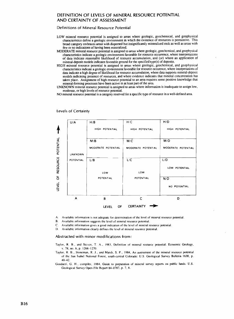
DEFINITION OF LEVELS OF MINERAL RESOURCE POTENTIAL AND CERTAINTY OF ASSESSMENT
Definitions of Mineral Resource Potential
LOW mineral resource potential is assigned to areas where geologic, geochemical, and geophysical characteristics define a geologic environment in which the existence of resources is permissive. This broad category embraces areas with dispersed but insignificantly mineralized rock as well as areas with few or no indications of having been mineralized.
MODERATE mineral resource potential is assigned to areas where geologic, geochemical, and geophysical characteristics indicate a geologic environment favorable for resource occurrence, where interpretations of data indicate reasonable likelihood of resource accumulation, and (or) where an application of mineral-deposit models indicates favorable ground for the specified type(s) of deposits.
HIGH mineral resource potential is assigned to areas where geologic, geochemical, and geophysical characteristics indicate a geologic environment favorable for resource occurence, where interpretations of data indicate a high degree of likelihood for resource accumulation, where data supports mineral-deposit models indicating presence of resources, and where evidence indicates that mineral concentration has taken place. Assignment of high resource potential to an area requires some positive knowledge that mineral-forming processes have been active in at least part of the area.
UNKNOWN mineral resource potential is assigned to areas where information is inadequate to assign low, moderate, or high levels of resource potential.
NO mineral resource potential is a category reserved for a specific type of resource in a well-defined area.
Levels of Certainty
U/A
UNKNOWN
POTENTIAL
H/B
HIGH POTENTIAL
M/B
MODERATE POTENTIAL
L/B
LOW
POTENTIAL
H/C
HIGH POTENTIAL
M/C
MODERATE POTENTIAL
L/C
LOW
POTENTIAL
H/D
HIGH POTENTIAL
M/D
MODERATE POTENTIAL
L/D
LOW POTENTIAL
N/D
NO POTENTIAL
B C
LEVEL OF CERTAINTY
Available information is not adequate for determination of the level of mineral resource potential. Available information suggests the level of mineral resource potential. Available information gives a good indication of the level of mineral resource potential. Available information clearly defines the level of mineral resource potential.
Abstracted with minor modifications from:
Taylor, R. B , and Steven, T. A., 1983, Definition of mineral resource potential: Economic Geology,v. 78, no. 6, p. 1268-1270.
Taylor, R. B., Stoneman, R. J., and Marsh, S. P., 1984, An assessment of the mineral resource potentialof the San Isabel National Forest, south-central Colorado: U.S. Geological Survey Bulletin 1638, p.40-^2.
Goudarzi, G. H., compiler, 1984, Guide to preparation of mineral survey reports on public lands: U.S.Geological Survey Open-File Report 84-0787, p. 7, 8.
B16

GEOLOGIC TIME CHART Terms and boundary ages used by the U.S. Geological Survey, 1986
EON
Phanerozoic
Proterozoic
Archean
ERA
Cenozoic
Mesozoic
Paleozoic
Late Proterozoic
Middle Proterozoic
Early Proterozoic
Late Archean
Middle Archean
Early Archean
PERIOD
Quaternary
Tertiary
Neogene
Subperiod
Paleogene
Subperiod
Cretaceous
Jurassic
Triassic
Permian
Carboniferous Periods
Pennsylvanian
Mississippian
Devonian
Silurian
Ordovician
Cambrian
(3800?)
EPOCH
Holocene
Pleistocene
Pliocene
Miocene
Oligocene
Eocene
Paleocene
Late Early
Late Middle Early
Late Middle
Early
Late Early
Late Middle Early
Late Early
Late Middle Early
Late Middle
Early
Late Middle Early
Late Middle
Early
pre-Archean 2
BOUNDARY AGE IN
MILLION YEARS
0.010
1.7
5
24
38
55
66
96 138
205
~240
290
-330
360
410
435
500
~ 5701
900
1600
2500
3000
3400
Accn _____
1 Rocks older than 570 m.y. also called Precambrian, a time term without specific rank.
2 Informal time term without specific rank.
B17

w H-» 00
TAB
LE 1
. M
ines
and
pro
spec
ts i
n th
e M
t. St
irlin
g W
ilder
ness
Stu
dy A
rea
and
vici
nity
[*, o
utsi
de s
tudy
are
a]
Map
No.
(pl.
1)Name
(commodity)
Summary
Workings
Samp
leand
resource da
ta
Stirling mine*
(gold)
Unna
med
prospect
(cop
per)
Best View
*
prospect
(copper-silver)
Mountain Boy
prospect*
(iro
n)
At least
two
main quartz veins as
much as
10
ft thick strike northeast, have various di
ps,
and
are
traceable for
at least
1,000
ft in
metasedimentary rocks, probably of
the
Wood
Canyon Formation.
Quartz veins are
parallel
and
about 800 ft apart.
Quartz is locally
brecciated, iron oxide st
aine
d, and
contains
traces of malachite, chalcopyrite, an
d ga
lena
. Nolan (1924) st
ated
th
at main quartz vein is
traceable for
several miles.
Iron
oxide stained argillite and
phyllite
country ro
ck ha
s tr
aces
of malachite,
siderite, and
calcite.
Light-gray to
white quartzite layer
of the
Stirling Quartzite contains iron oxide st
ains
an
d malachite.
Malachite is disseminated
throughout th
e rock and
also
present as
radiating crystals along fractures.
Irregular pods 10
ft long of
vu
ggy,
ha
rd,
dark-brown to
ye
llow
, iron-rich rock highly
altered to
limonite in
limestone country rock
striking N.
10°
E, an
d dipping 33
° E.
Main workings, at
east end
of
south vein,
include a
23-ft-
long
ad
it in quartz and
a 58-
ft-deep shaft.
Shaft
was
inaccessible bu
t appeared to
have drifts at two
leve
ls.
Also on south vein are
16
smal
l surface pits.
Two
shafts,
13 and
28 ft
deep,
and
11 small
pits
are
on north
vein
. Stockpiles of a
few
hundred pounds of quartz near
most of pi
ts.
1 10-ft-diameter pit
2 ft
deep
is in
an
area of
malachite-
stained argillite.
Small
stockpile ha
s phyllite
containing siderite an
d calcite.
Workings consist of an upper
bulldozer scraping about 85
ft
in
diameter.
About 400 ft
downslope north-northeast is
another bulldozer cut
about 70
ft lo
ng an
d 10 ft wi
de,
a pit
15 ft
lo
ng an
d 7
ft deep,
and
a 23-ft-long ad
it.
All
surface workings in
white
quartzite with disseminated
malachite; no malachite was in
adit.
A 4-ft-deep pi
t has a
10-ft-
long
extension at
bottom,
About 300 ft north is another
pit
8 ft
deep,
9 ft lo
ng,
and
5 ft
wide,
with a
100-lb
stockpile.
38 samples were ta
ken;
35 from small
stockpiles
and
from
veins exposed in
pits and
3 from
adit.
All
samples were of either massive or
brecciated vein quartz with iron an
d manganese
oxide stains.
Thre
e ch
ip samples of vein quartz
from adit contained trace, 0.
01,
and
0.09
oz/ton
gold.
Four select samples contained:
0.05
oz/ton go
ld with 0.1
oz/ton silver,
0.08 oz/ton
gold
with 0.5
oz/ton si
lver
, 0.18 oz/ton gold
with 0.3
oz/ton si
lver
, and
0.10 oz/ton go
ld.
A trace
of gold was
found
in 17 other sa
mple
s an
d a
trace
of silver was
found
in two
samples.
Eleven samples assayed for
copper,
lead,
and
zinc contained from trace
to 0.29 percent
copper,
trace
to 0.26 percent le
ad,
and
trace
to
0.02
percent zinc.
Nine
samples ha
d no
significant mineral values.
Four select samples and
thre
e chip samples were
take
n.
A select sample of
white quartzite with
disseminated malachite at south pi
t contained
0.01
oz/ton gold,
6.8
oz/ton si
lver
, and
7.5
percent copper.
Three samples (t
wo se
lect
, one
chip)
of white quartzite with disseminated
malachite and
veinlets of iron oxides from north
pit
assayed 2.2
oz/ton silver with 3.7
percent
copper,
0.5
oz/ton silver with 1.
48 percent
copp
er,
and
4.9
oz/ton silver with 4.
0 percent
copper.
Of two
chip samples taken from the
adit,
one
along north rid
in quartzite contained
0.1
oz/ton si
lver
. Select sample of
quartzite
with disseminated malachite from du
mp contained
9.6
oz/ton silver and
9.9
percent co
pper
.
One
chip
an
d tw
o select samples of
iron-rich
rock taken.
Three
samples contained from 44
percent to
51
percent ir
on,
0.018 percent to
0.049 percent copper,
0.058 percent to 0.135
percent lead,
and
0.064 percent to
1.3
percent
zinc.

TAB
LE 1
. M
ines
and
pro
spec
ts i
n th
e M
t. St
irlin
g W
ilder
ness
Stu
dy A
rea
and
vici
nit
y C
ontin
ued
Map No.
(pi.
1)Na
me
(commodity)
Summary
Workings
Samp
le and
resource data
Genevieve
prospect*
(gol
d)
Noonday prospect
(copper-silver)
10 11
Johnnie Snapper
prospect *
(copper-gold)
SMP
prospect
(copper-silver)
Home St
ake
,.prospect (gold)
Unnamed prospect
(gold)
Unnamed prospect
(copper-silver)
Sand
an
d gravel fills
creek bottom
White quartzite of the
Stirling Quartzite
strikes
N. 6° W.,
dips 26
° HE., an
d ha
s so
me
malachite st
ain.
White quartz in
randomly
oriented stringers and
in pods to
1 ft
diameter.
White quartz pods with tr
aces
of hematite,
malachite, azurite, an
d pseudomorphs of
limonite after pyrite in
phyllite an
d sandstone of the
Johnnie Formation.
Pods
of
quartz are
as much as
11 ft lo
ng an
d 1
to 2
ft
thic
k.
White quartz veins with thin stringers of
specularite, an
d malachite an
d chrysocolla
disseminated in
th
e Stirling Quartzite.
Vein
quartz with limonite and
calcite in
phyllite.
Well-fractured, heavily ir
on oxide-stained
quartz vein 1.7
ft thick
strikes N. 20°
E.,
and
dips
26°
SE.
in shale
of th
e Johnnie
Formation.
Fractured quartz pods with moderate iron oxide
stains and
traces of malachite an
d chalcopy-
rite in
limestone an
d phyllite country ro
ck.
In adit,
a slump block of limestone appears to
have slid over the
soil mantle covering
phyllite bedrock.
Ten-ft diameter pit
is about
6 ft de
ep.
Two
shafts:
one
inclined sh
aft
full
of
water is estimated to
be driven 15
ft
into the
malachite-stained quartzite;
about 1/2
mi so
uth,
a
19-ft
inclined shaft driven on a
shear zone in
quartzite
exposes numerous quartz
stringers and
pods.
One
pit
is 26
ft long,
10 ft
wi
de,
and
4 ft deep; another
is 5
ft in
diameter; another
is 6
ft deep with a
6-ft
extension at th
e bottom.
Two pits,
4 ft
and
7 ft
in
diameter, ar
e about 1/2
mi
apart.
Stockpile of about 30
0 Ib of iron oxide-stained
quartz containing specularite
is at westernmost pi
t.
One
pit
is 10 ft
long,
4 ft
wi
de,
and
3 ft deep.
One
small sloughed pit
and
an
18-ft-long inclined sh
aft.
An adit 28 ft
lo
ng along a
limestone-phyllite contact.
15-ft-long pi
t ne
arby
.
One
grab
sample of
sa
nd and
gravel taken
from
side of pit
contained no significant mineral
values.
Three select samples were ta
ken.
One
of
malachite-stained quartzite from dump of the
northernmost shaft
contained 7.4
oz/ton silver
and
0.49 percent copper.
Two
samples of quartz
from wall and
portal of
19-ft
shaft
contained no
significant mineral values.
Three
select samples ta
ken.
On
e of quartz with
hematite and
limonite from la
rges
t pit
contained
trace
gold
and
0.1
oz/ton si
lver
. Quartz sample
with malachite and
azurite fr
om the
6-ft-deep
pit
contained trace
gold,
0.6
oz/ton silver,
and
1.17
percent co
pper
. A
pod
with intermixed
quartz, limonite,
and
phyllite from the
smallest
pit
contained trace
copper and
zinc.
A select sample of quartzite with stringers of
specularite contained trace
silver an
d 0.016
percent co
pper
. A
select sample of
malachite-
and
chrysocolla-stained quartzite from
easternmost pi
t contained 1.4
oz/ton silver and
1.48
percent co
pper
.
A select sample of
vuggy, limonite-stained
quartz fl
oat
from
pit
contained trace
copp
er,
lead,
and
zinc.
A select sample of quartz from dump at
shaft and
a chip across quartz vein in
sh
aft
contained no
significant mineral values.
A select sample of malachite an
d ir
on oxide-
stained quartz from dump contained 0.1
oz/ton
silver and
0.91
percent co
pper
. A chip across
5.7-ft-wide quartz po
d with abundant limonite
stains ha
d 0.1
oz/ton silver an
d 0.018 percent
copper.
W I I \o

to
TAB
LE 1
. M
ines
and
pro
spec
ts i
n th
e M
t. St
irlin
g W
ilder
ness
Stu
dy A
rea
and
vici
nit
y C
ontin
ued
Map
No.
(pi.
1)
Name
(commodity)
Summary
Workings
Sample an
dresource da
ta
12
Moonshine
Light-gray quartzite unit of
the
Stirling
A water-filled inclined shaft
A ch
ip across malachite-stained quartzite at
prospect
Quartzite is 9
ft th
ick
and
contains
about 15
ft in
diameter and
inclined sh
aft
contained 0.
3 oz/ton si
lver
an
d(copper-silver)
disseminated chalcopyrite with some malachite
three
pits about
5 ft
in
0.88 percent copper.
Two
select sa
mple
s of
along fractures.
Quartzite is bounded above
diameter.
malachite-stained quartzite fr
om pi
ts contained
and
below by
red
silt
ite,
strikes N. 10°
W.,
4.3
percent copper with 0.7
oz/ton silver,
and
dips 55°
E.,
and
is mineralized for
185
ft
2.23 percent copper with 0.
3 oz/ton silver and
along strike.
trace
gold
.
13
El Lo
bo
Gray
quartzite country ro
ck contains a
white
A trench 5
ft deep an
d 15
Two
select sa
mple
s were taken
of vein quartz an
d prospect
quartz vein as
much as 20
ft thick
exposed for
ft long,
and
a 6-
ft diameter
quartzite from the
pits in
country ro
ck;
one
(gol
d)
300
ft.
Prospect along
trace
of Wheeler Pa
ss
shallow pi
t in
quartzite
sample contained 0.1
oz/ton silver.
Thre
ethrust fa
ult.
country ro
ck.
Four
pi
ts,
the
select samples of quartz were ta
ken
from 20-ft-
largest 15
ft
wide,
25 ft
thic
k quartz vein.
One
contained a
trace
of
long,
and
6 ft de
ep,
in or
go
ld and
0.1
oz/ton silver; another contained
near the
20-ft-thick quartz
0.1
oz/ton si
lver
, vein.
A caved
300-ft adit
reportedly on
property was
not
foun
d.
A 300-lb stockpile of
iron oxide-stained quartz and
quartzite ne
ar pi
t.


o >-a
O ^i oo Ln
I O
-P-
00
CO
V£>
Ln