Embed Size (px)
Citation preview

OPEN-FILE 92-567
MINERAL RESOURCE ASSESSMENT OF PUERTO RICO
FIELD TRIP June 25, 1992 .
Jean N. Weaver, Editor/Compiler U.S. Geological Survey
Trip Leaders:Mr. Ramon Alonso Harris
Department of Natural Resources, San Juan, Puerto Rico Mr. Johannes H. Schellekens
University of Puerto Rico, Mayaguez, Puerto Rico Mr. Gregory E. McKelvey
Phelps Dodge Mining Company, Tucson, Arizona Mr. Dennis P. Cox
United States Geological Survey, Menlo Park, California

TABLE OF CONTENTSpage
Table of Contents ............................................. iAcknowledgments ............................................. 1Cover Photo ................................................ 1Introduction ............................................... .2Itinerary ................................................. .2Geology of Puerto Rico ......................................... 2Cerro Avispa Gold-Silver-Copper Prospect .............................. 6
Geology .......................................... 6History ........................................... 7Origin of the Deposits .................................. 8To Reach Cerro Avispa ................................. 8
Geology of the Area: Southwest Igneous Province ........................ 12Geology and PGE Potential ...................................... 12Nickel Laterite Deposits ........................................ 15The Tanama and Helecho Porphyry Copper Deposits ...................... 17
Introduction ........................................ 17History of the Porphyry Copper Deposits ...................... 18Mineral Deposits .................................... 18Regional Environment ................................. 18Tanama Deposit ..................................... 19Geology .......................................... 20Feldspar-stable Alteration and Mineralization ................... 20Helecho Deposit ..................................... 21Geology and Structural Controls ........................... 21
Coal in Puerto Rico ........................................... 24Background ........................................ 24Present Study ....................................... 26Geologic Setting ..................................... 26San Sebastian Formation ................................ 28Coal ............................................ 28Rank of Coal ....................................... 28Methodology ....................................... 30Resource Estimates ................................... 30Depositional Setting ................................... 30
North Coast Karst Limestone and Ground Water Characteristics ................ 32Hydrogeologic Framework .............................. 33Karst Landforms ..................................... 34Caves ........................................... 34
References ................................................ 35

ILLUSTRATIONS
Figure 1. Schematic map of Puerto Rico ............................... 32. Stratigraphic nomenclature, Puerto Rico .......................... 43. Columnar section, northern Puerto Rico .......................... 54. Geologic map of hydrothermally altered zone and pre-Robles formations, Cerro
Avispa ............................................ 95. Location of Cerro Avispa gold-silver-deposits ...................... 106. Laterite deposits in western Puerto Rico ......................... 137. Location of Las Mesas laterite deposit .......................... 148. Location of the Tanama and Helecho porphyry copper deposits ........... 229. Geologic map of the Helecho deposit ........................... 2310. Location of the Lares coal localities ........................... 2511. Areal location of coaly and peaty materials ...................... 27
TABLES
Table 1. Summary of Ni-laterite resources ............................. 162. Classification of coals by rank ................................ 293. Total coal resources for the Lares coal field ....................... 31
11

ACKNOWLEDGMENTSThis trip and guidebook would not have been possible without the assistance from
numerous geologists who have worked extensively in Puerto Rico for the past several decades. Particular appreciation is extended to the faculty of the Department of Geology at the University of Puerto Rico in Mayaguez (UPR), the Department of Natural Resources in Puerto Rico (DNR), along with geologists from the United States Geological Survey's Water Resources Division (WRD) in San Juan. Individuals such as Johannes H. Schellekens (UPR), Ramon A. Harris (DNR), Greg McKelvey (Phelps Dodge Mining Company), and Joseph Troester (WRD) deserve our thanks for their assistance in this field trip.
ATLANTIC OCEAN
Arecibo
CARIBBEAN SEA
Puerto Rico showing the route of the field trip and location of the stops. An unscheduled stop occurred just east of Ponce where pillow lavas are nicely exposed (sketch of volcano). Lunch was at El Tuque park west of Ponce (sketch of umbrella). Location of Figure 8 was included but the site was not visited due to time constraints.
Cover Photo:
A view to the north from a hill 2.5 km southeast of Angeles, Puerto Rico. The surface in the foreground is a remnant of an erosional plane developed in early Oligocene time (around 35 million years ago). The Tanama porphyry copper deposit (about 40 million years old) is situated 1 km south of this point. Oligocene sedimentary rocks, including the Lares Limestone which forms the irregular karst topography in the distance, were deposited on this erosional plane and, at one time, probably covered the viewpoint as well as the partially eroded copper deposit to the south. (Caption by D.P. Cox, USGS; photo by J.N. Weaver, USGS).
1

Introduction
This field trip, brief in duration, is designed to introduce participants to a few of the outcrops and mineral deposits addressed during the previous two days of lectures. Due to time constraints only a few stops will be possible, but the trip should permit the participants to get a good feel of the overall geology of the island.
Itinerary
The trip will start and end at the Condado Beach Hotel in San Juan. The bus will head south along Interstate 52 and stop just east of Cayey at the Cerro Avispa deposit. Following a few brief stops, we will continue south on 1-52, through Ponce and head west (along Hwy. 2) to Mayaguez, where we will head east a short distance to the Las Mesas nickel laterite deposits. Schedule permitting, we will return to San Juan via the town of Lares where a brief stop will be made at the San Sebastian Formation to examine one of the coal outcrops. The trip back to San Juan will take us through the heart of quite spectacular karst topography.
A brief discussion of the porphyry copper of the Tanama and Helecho deposits has been included in the back of this report because of its potential importance. The outcrops in this deposit are difficult to reach by bus and will not be included on this field trip. Figures 1 and 2, respectively, show a schematic sketch of the geology of the island and stratigraphic nomenclature of the north coast middle Tertiary basin, Puerto Rico. A columnar section of the Middle Tertiary rocks in the northern part of the island is shown on figure 3.
GEOLOGY OF PUERTO RICOExtracted from
J.H. Schellekens, J. Joyce, A.L. Smith, and D.K. Larue1991
Puerto Rico is the easternmost island of the Greater Antilles and is a translational island-arc terrane with a geologic record of 140 million years. The island lies within the seismically active Caribbean-North American Plate boundary zone. The relative motion between the two plates is on the order of 2 cm per year and is taken up mainly by strong oblique underthrusting and left-lateral faulting in the Puerto Rico trench. A well defined southward dipping Benioff zone occurs under the eastern half of the island but is missing under the west side (McCann and Sykes, 1984; Schell and Tarr, 1978). Some plate motion and underthrusting also occur south of Puerto Rico in the Muertos Trough.
Puerto Rico and the Virgin Islands appear to be a separate tectonic block within the plate boundary zone. Puerto Rico is separated from Hispaniola on the west by a zone of active extension, which runs from the Mona Canyon through the southwestern quarter of the

Olig
ocen
c - M
ioce
ne l
imes
tone
No
rth
ea
st//
^ P
rovi
nce
lneo
us
Prov
ince
Icne
ous
Pro
vinc
e
Eoc
ene
volc
anic
and
S
edim
ents
ry R
ocks
Upp
er C
reta
ceou
s L
ayer
ed R
ock
s
Km
Low
er C
rcla
ceou
sL
ayer
ed R
ocks
Serp
entin
ile,
Che
rt,
Am
phib
olit
eB
asic
vol
cani
cs
Low
er T
erti
ary
Intn
isiv
cs
IH'H
M'l
Cre
tace
ous
Inln
isiv
cs
Figu
re 1
. Sc
hem
atic
geo
logi
c m
ap o
f Pue
rto
Ric
o (S
chel
leke
ns a
nd o
ther
s, 1
991)
. T
he n
orth
ern
Olig
ocen
e-M
ioce
ne l
imes
tone
bel
t al
so d
enot
es t
he N
orth
Coa
st T
ertia
ry B
asin
w
hich
com
pris
es t
he c
oal-
bear
ing
San
Seba
stia
n Fo
rmat
ion.

AGE MONROE (1980)SEIGLIE AND
MOUSSA (1984)
PLIOCENEQuebradillas Limestone
LUzLUo o
LU Z LU Oo o
LATE
Camuy Formation
Aymamon Limestone
EARLY Aguada Limestone
LATE
Unnamed
MontebelloLimestoneMember
MemberQuebradas Arenas Ls. Rio IndioLimestone Member
MIDDLE
Lares Limestone
San Sebastian Formation
Aymamon Limestone
Los Puertos Limestone
ou.oCOn O
Unnamed Member
IMontebello' Limestone i| Unlt
Lares Limestone
San Sebastian
Formation
Figure 2. Stratigraphic nomenclature of the north coast Middle Tertiary basin, Puerto Rico. (Modified from Ward et al., in press).

w
:AYMAMON LIMESTONE;
1TAGUADA LIMESTONES
^' ".'ffl-
»% * t T "^ \LIM ESTO'NE ~^j'- : g;
EXPLANATION
METRES LIMESTONE. SANDY LIMESTONE
CRETACEOUS TO EOCENE ROCKS (MAINLY VOLCANIC)
Figure 3. Columnar section of Middle Tertiary rocks in northern Puerto Rico. (Monroe, 1976)

island. On-land extensional faulting has produced the distinctive ridge and valley topography and generally low elevations of southwestern Puerto Rico. Eastern Puerto Rico and the northern Virgin Islands are separated from St. Croix and the Lesser Antilles by another active zone of extension, which formed the Whiting Basin (south of Puerto Rico), the Virgin Islands Basin, and the Anegada Passage.
Puerto Rico consists of volcanic, volcaniclastic, and sedimentary rocks of Late Jurassic to Early Tertiary age, which were intruded by felsic plutonic rocks during the Late Cretaceous and Early Tertiary, and are overlain by slightly tilted Oligocene and younger sedimentary rocks and sediments (Briggs and Akers, 1965).
Island-wide lithostratigraphic correlation within the basement rocks is difficult because individual units appear to have limited original lateral extent and the rocks have been strongly deformed and faulted. To overcome these correlation problems, earlier workers divided the island into structural blocks (Cox and Briggs, 1973) or subprovinces (Barabas, 1977). Here the island is divided into three igneous provinces, the southwestern igneous province (SIP), the central igneous province (CIP), and the northeastern igneous province (NIP) based on differences in stratigraphy, lithology, petrology and geochemistry (fig. 1).
Each igneous province contains a number of volcano-stratigraphic associations, identified as packets of volcanic and interstratified sedimentary rocks, where the age of the association is defined based on fossils in the sedimentary rocks. The boundaries of a volcano-stratigraphic association may be disconformities or unconformities (Schellekens, 1991).
Cerro Avispa Gold-Silver-Copper Prospect
Geology
The Cerro Avispa deposit occurs at the northwestern end of a large area of hydrothermaUy altered rocks southeast of the town of Cayey and is about 8 km long and 0.5 to 2 km wide running WNW-ESE. The alteration is superimposed on a sequence of WNW dipping volcanic flows and flow breccias ranging in composition from basaltic andesite to andesite. To the NE and SW, the flows are interstratified with volcanic siltstones and sandstones (Berryhill and Glover, 1960). The spatial arrangements of these lithologies suggest an association of proximal volcanic rocks flanked by more distal volcaniclastic rocks. The volcanic rocks typically contain abundant pyrite. Along a NW striking deformation zone the pyrite has oxidized, bleaching the rocks and leaving pyrite casts and Fe-hydroxides on fracture planes (Schellekens, 1987). Mineralized rocks occur at the top of this pile of volcanic rocks at the northwestern end of the hydrothermally altered zone, in intensely altered volcanic breccia.

The mineralized area consists of sulfide-bearing quartz veins in an area of generally silicified and pyritized rocks. Reconnaissance sampling by Bergey (1960) had contents ranging from 1 to 17 oz/ton Au and 0.1 to 14 oz/ton Ag. The highest gold and silver values were found in samples with visible chalcopyrite and sphalerite (Bergey, 1960). Chip samples of quartz veins with abundant sulfides yielded 2.1 percent Cu, 1.2 percent Zn, and 15.1 percent Pb (Ludden, 1961a). Ludden (1961a) reports that samples from the NW striking altered zone showed Cu contents of 80 to 420 ppm, but no Au and Ag.
History
In 1956, a mineral exploration program was initiated by A.D. Fraser from Kingston, Jamaica (Ludden, 1961a; Bergey, 1963). In 1957 Mr. Fraser was granted a number of Exclusive Prospecting Permits by the Mining Commission of the Commonwealth of Puerto Rico. One of these permit areas was the Cayey permit area of about 206 sq. miles (527 km). In June 1960, quartz veins were discovered with Au, Ag, and Cu values in the Cerro Avispa area, southeast of Cayey in the Cayey permit area.
Prospecting and sampling of the prospect area indicated a large number of mineralized veins in an area of about 2 by 1 miles. About 1 mile to the west of the first discovery numerous excavations were noted, including an open cut of more than 200 ft (30 m) long and at least 10 ft (3 m) deep. According to the local farmers, this mining activity was carried out around 1860 by the Spaniards. Based on this first reconnaissance, a map delineating areas of interest was produced in which the gold contents were displayed. Gold contents ranged from 3 to 434 ppm, silver values from 31 to 527 ppm.
In August 1960, R.B. Ludden carried out a preliminary investigation and based on his recommendation, Phelps Dodge acquired an option on the Fraser prospects, and in November 1960 started a program of geologic reconnaissance and geochemical sampling (Ludden, 1961a). The study of the Cerro Avispa gold-silver-copper vein prospect by this company revealed a fairly large area of narrow, widespread, steeply dipping quartz veins varying in strike from N-S to NW-SE. In the quartz veins and the adjacent country rock, varying amounts of pyrite, chalcopyrite, sphalerite, and supergene chalcocite were reported (Ludden, 1961a).
Following the initial exploration, a detailed proposal for intensive exploration was submitted. Within the prospect, four vein systems were selected which contained high grade Au-Ag quartz veins, sometimes with Cu, in the central and eastern part of the Cerro Avispa area. The company proposed to undertake 1,800 ft (550 m) of drilling; drive an exploratory adit of 1,250 ft (380 m) and carry out 40 days of trenching. As far as is known, these exploration activities were never carried out.

About 1983, COMINCO American Resources Inc. initiated a new exploration program in Puerto Rico. One of the prospects of interest was the Cerro Avispa deposit. COMINCO carried out an initial geological and geochemical investigation and applied for an exploration permit. To date, no gold has been extracted.
Origin of the Deposits
Pease (1976) suggested that the sulfide deposits at Cerro Avispa may have formed from hydrothermal fluids carried along NW-SE fault zones from late magmatic differentiates of the San Lorenzo Batholith at Punta Tuna near Puerto Maunabo. Schellekens (1987) proposed that the sulfide deposits were the result of emanations near a volcanic center on top of the Early Cretaceous volcanic pile (fig. 4). The subaerial environment for the volcanics as suggested by Berryhill and Glover (1960), combined with precious metal bearing quartz vein-system, suggests an epithermal vein deposit.
STOP 1: To reach Cerro Avispa (fig. 5):
Take 1-52 south from San Juan and exit at Cayey. Follow Hwy. 1 south, turn left under 1-52 and then right on 7736. From kilometer marker 0.6, the road goes through outcrops with hydrothermally altered volcanic rocks on the flanks of Monte El Gato. The rocks probably were feldspar porphyry flows. Now the feldspars are altered to white clay occurring in a red clay groundmass. Numerous small veinlets cut across the outcrop.
ROAD LOG FROM STOP 1 TO STOP 2:
From kilometer markers 2.9 to 3.1, the rocks appear to be intensely altered. The groundmass now consists of bleached white clay and veins with white clay cutting the rock. Abundant iron oxide casts are present.
At kilometer marker 3.4 turn left on Hwy. 715 to the Cerro Avispa deposit. Stop 1 is an outcrop of argillically altered andesite with crosscutting quartz veins. Stop 2 shows boulders of ferricrete. The field trip only stopped at Stop 1. Buses were unable to travel the road between Stop 2 and Stop 1. Figure 4 locates the Cerro Avispa deposit in relation to the hydrothermally altered zone and pre-Robles Formation. The pre-Robles Formation refers to the geologic units which are older than the Albian-Santonian units of the Robles Formation.
Return on route 715, cross under 1-52 to route 1. Turn right on route 1 north, towards Cayey. In Cayey, take 1-52 towards Ponce (south).
At kilometer marker 44.2,1-52 intersects the hydrothermally alterated zone related to the Cerro Avispa deposit.
Jibaro Monument: 1-52, Km 49.7: this monument is dedicated to all the people in the country who work the land. The monument is on the right side of the road with good parking.
8

92-567
Figure 5. Location of C
erro Avispa G
old-Silver-Copper D
eposits. Stops 1 and 2 are marked.
Cayey 1:20,000 scale topographic sheet.

Figure 4. Geologic map of the hydrothermally altered zone and pre-Robles formations along Route 15 from Guyama to Cayey with location of Cerro Avispa deposit. Geology: Berryhill and Glover (1960) (Schellekens, 1987) scale 1:20,000 Legend: 1: Boundary; 2: fault; 3: veins; 4: river; 5: road
H: hydrothermally altered rocksA, B, C, and D: formations
^«jVJt ivvvvvV V V V fl V V V V VvvvVV V V » v w , , . .VVVVVVVVVVVVVVVVVVVV» » .,. VVVVVVVVVVVVVVVVVVVVVVVVVpVVVVVVM I p .^vvvvvvvvvvvwvvvvvvvvvvw/vvvvvvv« I 1 : TV vvvvvvvvvvvvvvvvvvvvvvvvVvvvvvwi I I, * VVVVWVVVVWVVVVVVVVVVVV'SsVVV V V V V\ I V { « VVVVVVVVVVVVVVVVVVVVVVVV V V>iUi V V V \ x ft f,
----..««uuvvwvvv v«v v v v v v vwv v v v n\ r"" --..^wwvUvVVX: J I;?
V V V V V V V » V, ....v V v V v V vy y y v.<<^.> "nT*B' 'iiafi 'VV>> A £*"2TA A A A A
^^' * A A A A A A ,
H
« D

The surrounding rocks are Early Cretaceous volcaniclastic rocks. The Las Tetas Lava Member of the Robles Formation (Albian to Santonian) crop out to the northwest, in a conspicuous pair of bald knobs bearing the same name.
Between kilometer markers 54.4 and 59, we see volcanic and volcaniclastic rocks mapped as the Early Cretaceous "pre-Robles Formations" (Berryhill and Glover, 1960). The low ridges in the valley below are the eastern extension of the Eocene Belt.
On 1-52, between kilometer markers 59.8 and 60.9: Lapa Lava Member of the Robles Formation (Albian-Santonian) is well exposed. The outcrop exposes spectacular pillows and other submarine lava-flow features. The basaltic rocks are pyroxene and porphyries, with typical characteristic cruciform texture of the feldspars (Jolly, 1971). These calc-akaline lavas with high K2O contents are more or less contemporaneous with the tholeiitic low K2O Las Tetas lavas.
At kilometer marker 68.3, we saw an outcrop consisting of folded limestone in the northeast and a melange of limestone and purple volcaniclastic blocks in a bedded sandy matrix in the southern part. The section is mapped as Cuevas Limestone (Eocene) and Coamo Formation (late Cretaceous). The section is part of the Eocene Belt and the Great Southern Puerto Rico Fault zone (Glover, 1971; Glover and Mattson, 1973).
LUNCH at El Tuque park just west of Ponce.
At kilometer marker 82.9, the highway intersects outcrops of the nearly vertical beds of interbedded sandstones and mudstones containing sedimentary structures of typical turbidite deposits. The rocks probably belong to the Eocene Raspaldo Formation.
Between kilometer markers 87.3 and 86.8, outcrops on both sides of the highway contain coarse conglomerate interlayered with red-colored finer-grained sediments. Bottom contacts of the conglomerates are scoured and often show reverse grading. The unit is mapped as part of the lower clastic member of the Oligocene Juana Diaz Formation (Krushensky and Monroe, 1975).
On 1-52 at kilometer marker 97.3: Juana Diaz Formation is visible consisting of a limestone mass about 115 m wide and 15 m thick occurring within the pelagic claystones of the Juana Diaz Formation. The limestone is made up entirely of biogenic material, predominantly calcareous tests and skeletal fragments of shallow-water organisms. The limestone mass has been interpreted as a dislodged block of an algal bank that had slid into a deep-water environment (Moussa, 1977).
11

Geology of the Area: Southwest Igneous Province
Extracted and modified fromJ.H. Schellekens, J. Joyce, A.L. Smith, and D.K. Lame
1991
The Southwest Igneous Province of Puerto Rico is distinct from the rest of Puerto Rico in the occurrence of outcrops of three serpentinite belts. These serpentinites contain rafts of metavolcanic rocks and cherts that are dated as being the oldest rocks of Puerto Rico and were mapped as the Bermeja Complex (Mattson, 1960). Cherts as old as Kimmeridgian (Montgomery, 1990; Schellekens and others, 1990) and amphibolites dated at 126 Ma (Cox and others, 1977) occur in the Sierra Bermeja. These rocks are overlain by Cenomanian to Eocene, basic to intermediate volcanic and volcaniclastic rocks, and limestones that are intruded by small, probably shallow, plutonic rocks (fig. 3).
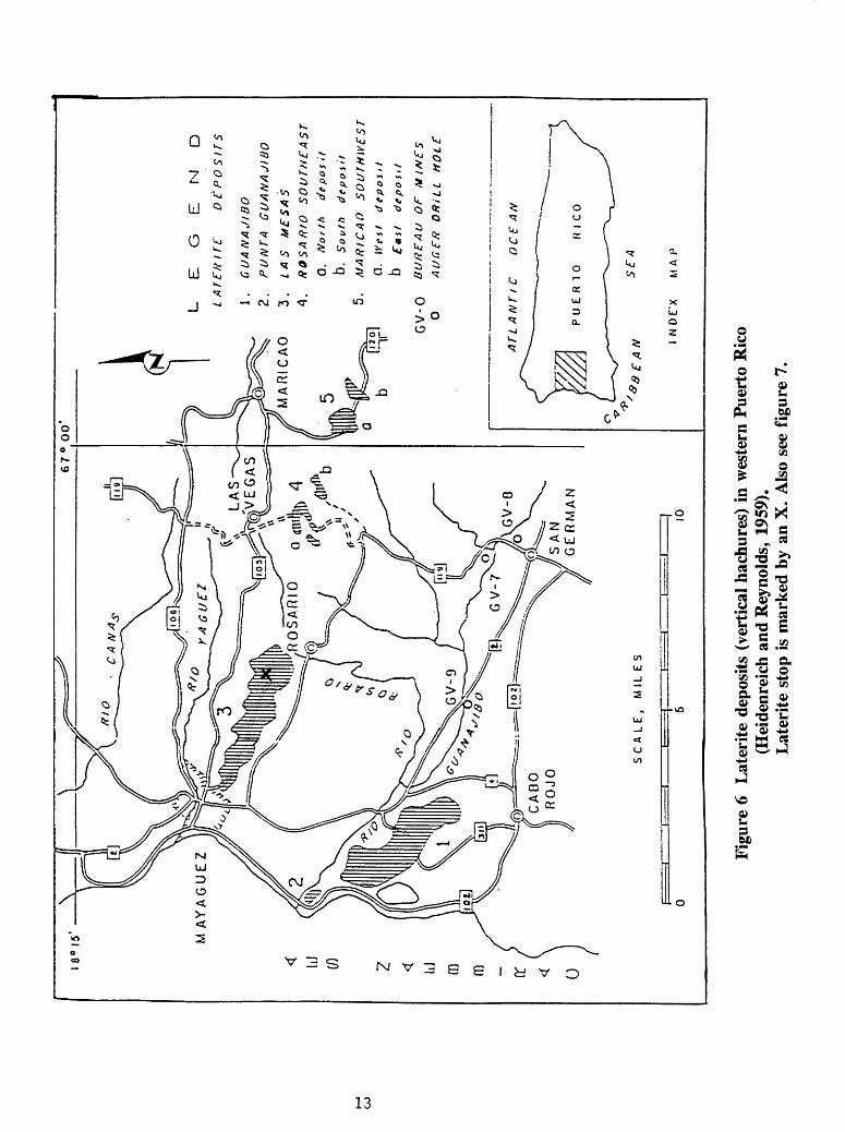
Of the three serpentinite belts that crop out in southwest Puerto Rico (Mattson, 1960) the two northern belts are locally capped by laterite deposits (fig. 6). These have been studied in the past to assess their potential as a source for nickel, cobalt, iron, and chromium. The two largest deposits, Las Mesas (figs. 6 and 7) and the Guanajibo-Punta Guanajibo (fig. 7), were extensively drilled; the other small deposits were tested with only a few holes at readily accessible sites. A total of 10,856.5 ft (3,250 m) in 279 holes was drilled. Based on a cutoff of 0.6 percent Ni, the reserves were inferred to be 90.5 million short tons with an average nickel content of 0.88 percent. The enriched zones average in thickness from 10.5 ft (3.2 m) to 51 ft (15.4 m), with a mean of about 19.5 feet (6 m) (Heidenreich and Reynolds, 1959). A restudy of the Guanajibo deposit by the "Comision de Mineria" of Puerto Rico, that put in 12 drill holes with a total length of 545.1 ft (170 m), came up with more accurate figures than previous estimates (Cram, 1972).
GEOLOGY AND PGE POTENTIAL
ByBruce Lipin, Johannes Schellekens, and Alien L. Meir
USGS UPR USGS Reston, Va. Mayaguez, PR Denver, Colo.
The nickel-bearing laterites in Puerto Rico are located on the southwestern end of the island and overlie serpentinized ultramafic rocks. The laterite deposits are in an area roughly bounded by Mayaguez (NW), Maricao (NE), San German (SE) and Cabo Rojo (SW) (fig. 6). The ultramafic rocks were emplaced over a period of time that probably began in the Late Cretaceous (Mattson, 1960) and ended in the Eocene (R.D. Krushensky, 1991, oral communication). Mattson (1960) believed that the ultramafic rocks were exposed sometime during the Eocene, at which time the present-day laterite began to form. However, Krushensky (1978) presented evidence that deposition in western Puerto Rico had been
12

92-567
Faro©
fAY
AG
UEZ
Faro
0
Faro®
<-,- li
V^H
£",tl
^4
' '^
«^*
^
Mr^
^-r^
asy
^j^
vV
i^ .
: - »< Ci
"-i*,«
v
xv'O ^«
W5
^ '
Y^^^'^lfci^^^^u
Figure 7. Location of Las M
esas laterite deposit.M
ayaguez and Rosario 1:20,000 scale topographic sheets
8°I
5' X
j
67
° 0
0'
LE
G
LA
TE
fflT
E
EN
D
DE
PO
SIT
S
1.
GU
AN
AJIB
O
2.
PU
NT
A
GU
AN
AJIB
O
3.
LA
S
ME
SA
S
A.
RO
SA
RtO
S
OU
TH
EA
ST
0.
No
rth
d
ep
osit
D.
So
uth
deposit
5.
MA
RIC
AO
S
OU
TH
WE
ST
Q.
We
st
deposit
D
fast
de
po
sit
GV
-0
BU
RE
AU
O
F
MIN
ES
O
AU
GE
R
DR
iLL
AT
LA
NT
IC
OC
EA
N
E A
NS
EA
I N
DE
'X
MA
J1
Figu
re 6
L
ater
ite
depo
sits
(ve
rtic
al h
achu
res)
in
wes
tern
Pue
rto
Ric
o (H
eide
nrei
ch a
nd R
eyno
lds,
195
9).
Lat
erit
e st
op i
s m
arke
d by
an
X.
Als
o se
e fi
gure
7.

continuous from the Cretaceous to the Middle Eocene. In either event, it seems clear that the great majority, if not all, of the laterite formation took place between the Middle Eocene and the present.
Of the several studies of the laterites, the most extensive was by Heidenreich and Reynolds (1959), in which 279 drill holes totaling nearly 9,000 ft (2,700 m) were examined and assayed for Ni, Co, Fe, and Cr. Table 1 summarizes the resources of Ni, Co, Fe, and Cr based upon a 0.6 percent Ni cutoff. Cram (1972) did more drilling in the largest of the deposits, the Guanajibo, and estimated 37 million tons of laterite at 1.2 percent Ni. The other metals were not estimated by Cram. The two estimates are remarkably close in terms of the amount of nickel in the Guanajibo area. Heidenreich and Reynolds' (1959) figures yield about 410,000 tons of nickel whereas Cram's figures yield about 440,000 tons of nickel (to the nearest 10,000 tons in each case).
Here, the results of a reconnaissance sampling of the laterite for platinum group elements (PGE) in several areas are presented. Samples were collected at various locations where a complete, or nearly complete, section of laterite from the serpentinite to the iron cap was present. The samples were analyzed for PGE by Induction-Coupled Plasma-Mass Spectrometry (ICP). The PGE concentrations in the laterites are higher than in the serpentinite directly below by a factor of 4.3 to 11.7 and averaging 7.4. The highest total concentration of PGE is in the Maricao East deposit (about 340 ppb). In almost every profile the content of PGE increases just above the laterite-serpentinite contact and remains high throughout the laterite profile. Only in the upper part of the Las Mesas-1 locality does the PGE content drop back to near serpentinite levels. Preliminary geochemical analysis of other elements indicates a good correlation between PGE and cobalt. However, further detailed study will be necessary in order to determine the relation of the changes in PGE to other chemical changes that have occurred in the laterite. All the samples were also analyzed for gold and none were found to contain more than the detection limit of 0.01 ppm.
Data presented here are not detailed; however, they do show significant increases in PGE concentration in Puerto Rican laterites over that of bedrock. These increases suggest similarities to the laterite developed over some Alaskan-type complexes in New South Wales, Australia (Elliott and Martin, 1991). Detailed exploration and drilling revealed that PGE concentrations in one of them, the Tout complex, has typical grades of platinum of 20 to 50 ppb in dunite and 800 ppb in the overlying laterite, with some assays as high as 16 ppm (Derrick, 1991). If that kind of enhancement is encountered in western Puerto Rico as a result of subsequent, more detailed study, PGE values of hundreds of ppb to perhaps 1 ppm may be encountered. Based on these observations, the Puerto Rican laterites may be considered a speculative resource for platinum group elements.
STOP 2: Nickel laterite deposits (location on fig. 7)
Take Hwy. 2 north to Mayaquez, turn right on Hwy. 106, right on 348 then left to 349. Go past the Hospital Bella Vista and 5 km down the road, on the left is an excellent
15
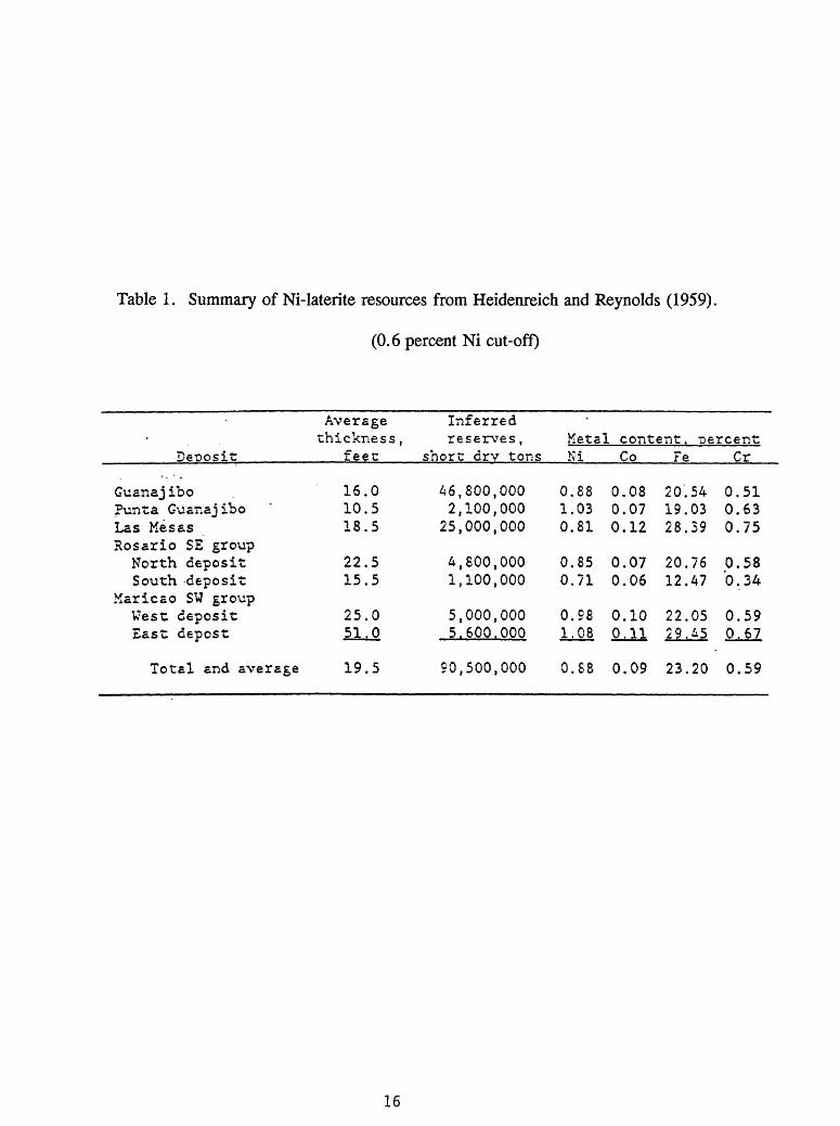
Table 1. Summary of Ni-laterite resources from Heidenreich and Reynolds (1959).
(0.6 percent Ni cut-off)
Deposit
Guana j iboPvmta Guanaj iboLas MesasRosario SE groupNorth depositSouth deposit
Maricao SW groupVest depositEast oepost
Averagethickness ,
feet
16.10.18.
22.15.
25.
055
55
051^0
Inferred reserves ,
short drv tons
462
25
41
55
,800,100,000
,800,100
,000,600
,000,000,000
,000,000
,000,000
Ketal content. Ni Co Fe
0.1.0.
0.0.
0.1.
880381
8571
9808
0.080.070.12
0.070.06
0.10fiJLl
20.19.28.
20.12.
22.29.
percent Cr
540339
7647
0545
0.510.630.75
0.580.34
0.590.67
Total and average 19.5 90,500,000 0.88 0.09 23.20 0.59
16

exposure for the nickel laterite deposit at Las Mesas. This stop is located on the Rosario 1:20,000 scale topographic sheet.
The Tanama and Helecho Porphyry Copper Deposits
Extracted and modified fromD.P. Cox
1985
The Late Cretaceous to Lower Tertiary volcanogenic rocks (fig. 3) that occur south of the Late Cretaceous Utuado Batholith are intruded by Lower Tertiary plutons, some of which may be hosts for porphyry copper-gold deposits (fig. 3) (Cox, 1972; Cox and others, 1973, 1975b; Barabas, 1977).
Introduction
The Tanama and Helecho copper deposits (figs. 8 and 9) are situated in west- central Puerto Rico. The area, which includes these deposits and two associated copper prospects, extends 8 mi (13 km) eastward and 4.6 mi (7.5 km) southward of the town of Lares and encompasses the southern third and the northern most part of Bayaney and Monte Guilarte 7*/2 minute quadrangles.
This area is characterized by gently rolling uplands dissected by streams with very steep valley slopes. The uplands rise gently from 1,000 ft (300 m) elevation in the north to a drainage divide in the southern edge of the map area at approximately 2,000 ft (600 m) elevation. The area has an annual rainfall of 80-100 in (200-250 cm) and supports a heavy vegetation cover. The area has been extensively cultivated in the past, and native vegetation has been replaced largely by coffee, banana, and orange groves and intervening areas of pasture.
Copper deposits in this area have been known since 1958. Their discovery by geologists of the Kennecott Copper Corp. was followed by extensive geologic mapping and diamond drilling. Results of this work were summarized in two reports by I.E. Welsh (unpub. data, 1965) and J.C. Wilson (unpub. data, 1966), which were made available to the writer by the Kennecott Copper Corp. and the Puerto Rico Mining Commission. Geologic mapping of the Bayaney quadrangle by Nelson and Tobisch (1968) laid much of the groundwork for the present study, as did later mapping in the Monte Guilarte quadrangle by R.D. Krushensky and A.F. Curet (unpub. data, 1978). Weaver (1958) and Chen (1969) published petrologic studies of the Utuado batholith that underlies part of the area, and Cox and others (1973) published a brief account of porphyry copper mineralization and alteration in Puerto Rico in which the deposits of the map area were described.
The present study was carried out in cooperation with the Department of Natural Resources of the Commonwealth of Puerto Rico. The main objective of this study
17

was to describe the mineralogic and geochemical characteristics of a porphyry-type deposit in a potassium-deficient geologic environment that differs markedly from that of most porphyry copper deposits in the conterminous United States.
History of the Porphyry Copper Deposits
In 1950, the Kennecott Copper Corp. recognized the possibility of porphyry copper mineralization in Puerto Rico. Following reconnaissance, an exploration concession for west-central Puerto Rico was obtained in 1958. Surface mapping and stream-sediment geochemical analyses were carried out in 1959. The first deposit drilled was Laundry Creek, followed by Copper Creek, Helecho, and Tanama deposits. By 1965, 155 holes were drilled with a total length of 12,150 ft (44,000 m) (Cox, 1985). Reserves are estimated at about 139 million tons at 0.64 percent copper (Lutjen, 1971). In 1957, W.R. Bergey discovered copper mineralization in the Rio Vivi area. Subsequent drilling by American Metals Climax outlined two ore bodies containing more than 100 million tons of ore at 0.8 percent copper (Cox and others, 1975b).
In 1965, Kennecott Copper Corp. and American Metal Climax Corp. (Amex), through their subsidiaries Cobre Caribe S.A. and Ponce Mining Co., Inc., applied for a mining lease but were not successful (Lutjen, 1971).
Mineral Deposits
Of the two main porphyry copper deposits and two porphyry-type prospects, Tanama is the largest with 139 million tons of ore averaging 0.64 weight percent Cu (proved by diamond drilling). The Helecho deposit, 1 mi (1.5 km) to the south, contains a slightly smaller amount of ore of about the same grade. The Laundry Creek prospect appeared to be highly attractive on the basis of limited outcrops and geochemical expression but was found on drilling to have too small a tonnage for economic interest. The Copper Creek prospect is also a small occurrence and shows economic-grade mineralization in only one drill hole.
Regional Environment
The relation of porphyry copper mineralization to the geologic development of Puerto Rico and adjacent areas, as described by Barabas (1971, 1982) and Cox and others (1977), can be summarized as follows:
1. Early sedimentary, volcanic, and tectonic events in southwestern Puerto Rico are recorded in rocks of Bermeja Complex of Mattson (1959, 1960).
2. The Bermeja Complex is overlain by volcanic and sedimentary rocks as old as Cenomanian that are part of a thick sequence of basalt, andesite, and breccia, conglomerate, sandstone, and shale derived from volcanic rocks, which were deposited from Albian time to
18
the end of the Cretaceous Period. Volcanic activity affected the regional tectonics from Cenomanian to Eocene time.
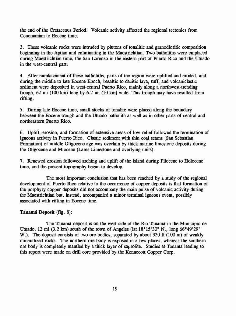
3. These volcanic rocks were intruded by plutons of tonalitic and granodioritic composition beginning in the Aptian and culminating in the Maestrichtian. Two batholiths were emplaced during Maestrichtian time, the San Lorenzo in the eastern part of Puerto Rico and the Utuado in the west-central part.
4. After emplacement of these batholiths, parts of the region were uplifted and eroded, and during the middle to late Eocene Epoch, basaltic to dacitic lava, tuff, and volcaniclastic sediment were deposited in west-central Puerto Rico, mainly along a northwest-trending trough, 62 mi (100 km) long by 6.2 mi (10 km) wide. This trough may have resulted from rifting.
5. During late Eocene time, small stocks of tonalite were placed along the boundary between the Eocene trough and the Utuado batholith as well as in other parts of central and northeastern Puerto Rico.
6. Uplift, erosion, and formation of extensive areas of low relief followed the termination of igneous activity in Puerto Rico. Clastic sediment with thin coal seams (San Sebastian Formation) of middle Oligocene age was overlain by thick marine limestone deposits during the Oligocene and Miocene (Lares Limestone and overlying units).
7. Renewed erosion followed arching and uplift of the island during Pliocene to Holocene time, and the present topography began to develop.
The most important conclusion that has been reached by a study of the regional development of Puerto Rico relative to the occurrence of copper deposits is that formation of the porphyry copper deposits did not accompany the main pulse of volcanic activity during the Maestrichtian but, instead, accompanied a minor terminal igneous event, possibly associated with rifting in Eocene time.
Tanama Deposit (fig. 8):
The Tanama deposit is on the west side of the Rio Tanama in the Municipio de Utuado, 12 mi (3.2 km) south of the town of Angeles (lat 18°15'30" N., long 66°49'29" W.). The deposit consists of two ore bodies, separated by about 320 ft (100 m) of weakly mineralized rocks. The northern ore body is exposed in a few places, whereas the southern ore body is completely mantled by a thick layer of saprolite. Studies at Tanama leading to this report were made on drill core provided by the Kennecott Copper Corp.
19

Geology
Three tonalite porphyry bodies enclosed in metavolcanic rocks of the Cretaceous basaltic sequence are hydrothermally altered and mineralized in the Tanama area. These porphyry bodies show no textural or compositional features, other than degree of alteration and mineralization, that distinguish them from tonalite porphyry bodies elsewhere in the region. Contact relations of the porphyry stocks, which were unobservable at the surface, can only be indirectly inferred from drill-core studies. Drill-hole intercepts of mixed porphyry and metavolcanic rocks, tens of meters long, around many porphyry contacts suggest intrusion by magmatic stoping of metavolcanic rocks. Contacts dip steeply to vertically, except in the northwestern part of the deposit. There, drill-hole intercepts show that the narrow screen of metavolcanic rocks separating the northwestern and northeastern plutons dips 40° to 60° W. The western contact of the northwestern pluton also dips west. The plutonic and metavolcanic rocks are intensely fractured, altered, and mineralized and weather to a white to light-tan saprolite containing abundant limonite segregations and relict veinlets. Drill holes intercept dark-colored tonalite porphyry dikes mapped on the surface by Kennecott Copper Corp. geologists. These dikes, which intrude ore zones but have a very low Cu content, are here referred to as postore porphyry. Postore porphyry, which has a groundmass texture that is microaplitic (0.01 to 0.02 mm), is indistinguishable from the tonalite porphyry bodies that are widespread in the Bayaney quadrangle. Postore porphyry contains clusters of epidote and veinlets of calcite. Chemical analysis of some samples showed very high Zn contents, probably derived from sphalerite in calcite veins.
Some of the contacts between the porphyry bodies and metavolcanic rocks are probably faults, although this conclusion was not confirmed by the present study. Maps by Kennecott Copper Corp. geologists, presumably based on studies of fresh bulldozer cuts, show faults separating the northeastern porphyry body from the other two and bounding the southeast side of the two larger intrusions.
Feldspar-Stable Alteration and Mineralization
Two feldspar-stable hydrothermal-mineral assemblages, found in the northern ore body and in the deeper parts of the southern ore body, are: intermediate plagioclase + quartz + hornblende + magnetite ± chalcopyrite and intermediate plagioclase + quartz + chlorite + magnetite ± chalcopyrite ± biotite ± actinolite ± epidote ± potassium feldspar. Both assemblages are characterized by the preservation of intermediate plagioclase (An45.60) in which igneous oscillatory-zoning patterns are commonly present. The boundary between these zones is indistinct and gradational.
The presence of abundant veinlets of quartz, quartz-magnetite, and quartz- chalcopyrite without hydrothermal-alteration haloes distinguishes these assemblages from those of porphyry bodies and metavolcanic rocks elsewhere. In other respects, the amphibole-dominated assemblage resembles the hornblende-hornfels mineral assemblage common in the Cretaceous basaltic sequence, and the chlorite-dominated assemblage resembles regional-alteration assemblages developed in Eocene porphyry bodies throughout
20

the deposit. Both the regional-alteration and ore-zone -alteration assemblages present in Eocene porphyry bodies are mineralogically equivalent to the propylitic-alteration assemblages that surround many porphyry systems in the Andean and North American Cordillera. Cox (1985) proposed that the chlorite dominated assemblages were the product of retrograde hydrothermal alteration of an original potassic assemblage. Thus the chlorite was formed by replacement of earlier formed hydrothermal biotite during late circulation of meteoric fluids.
Chemical analyses of rocks with feldspar-stable alteration compared with unmineralized tonalite porphyry, indicate higher SiO2 contents due to introduced quartz as veinlets and lower Al2O3j CaO, and Na2O contents due to dilution of these components by the addition of quartz. K2O content is doubled by the presence of small veinlets with sericitic alteration haloes.
Helecho Deposit (figs. 8 and 9):
The Helecho deposit is coextensive with a tonalite porphyry intrusion that crops out along the Rio Coabey 1 km south of the Tanama* deposit. Although most of the deposit is mantled by a thick saprolite layer, the deposit is well exposed in the river and has been penetrated by 31 vertical diamond-drill holes.
A detailed geologic traverse along the Rio Coabey was made during 1971 and 1972, extending from its confluence with the Rio Tanama to a short distance south of the Helecho deposit. South of the deposit, the streambed lies above the saprolite-rock contact, and fresh samples are unobtainable (Cox, 1985).
Geology and Structural Controls
The tonalite porphyry at Helecho resembles porphyry bodies elsewhere in the map area and exhibits the same wide ranges in grain size, phenocryst spacing, and groundmass texture already described. Quartz phenocrysts are less common at Helecho than in the other porphyry bodies, and unaltered postmineral dikes contain both hornblende and clinopyroxene phenocrysts. Contact relations with Cretaceous and Tertiary metavolcanic rocks are obscured by absence of outcrops. The metavolcanic rocks are altered to sericite and clay in most places. Rocks in these areas contain the conspicuous relict phenocrysts of pyroxene replaced by amphibole that are characteristic of the Cretaceous basaltic sequence.
Abundant outcrops of mineralized porphyry in the Rio Coabey permit a study of the pattern of mineralized fractures in and around the Helecho deposit. The data from the Helecho porphyry indicate that 95 percent of these fractures are within 20° of vertical and that 90 percent are oriented in two preferred strike directions of about N. 18° W. and N. 2° E.; a smaller number of steeply dipping fractures have strikes clustering around N. 75° W., N. 65° E., and N-S. These orientations, which match closely the strikes of relict veinlets in saprolite measured at Tanama, indicate that the fracturing of both deposits took place in
21

Figure 8. Location of the Tanama and Helecho porphyry copper deposits. Bayaney and Monte Guilarte topographic sheets scale 1:20,000 22

113500 METERS 114000 MEUFS
EXPLANATION
Metavolcemc (Teilisryl
Contact-lrferred
Limit of gresier-thEn-0.«-rteight-percer.i Cu minerelizstton Hachured on side of hightr grade
Diamond drill hole snd number
Hydrothermal slleraiion assemblages
Feldspar destructive
Feldspar stable Ichlornel
Rock types
Post-ore dikes (Tertisryl
Tonalite porphyry (Tenisry)
^6000
METERS
,H51
45500 METERS
Figure 9. Geologic map of Helecho deposit. Coordinates in meters, Puerto Rico coordinate system (Cox, 1985)

response to a regional stress rather than to stresses localized around individual plutons. The symmetry of the maxima suggests that the Helecho deposit has not been rotated, as may have been the case for the Tanama deposit.
Data from the altered volcanic rocks near Helecho give a distinctly different pattern of poles. The strongest maximum corresponding to a set of N. 30° E.-striking vertical fractures is absent in the Helecho porphyry data. This maximum,, which corresponds closely to the N. 30° E. trend of porphyry plutons, may represent a N. 60° W.- oriented tensional stress that existed before crystallization of those plutons and that may have been relieved by intrusion of the porphyry magma. Data from the volcanic rocks show four maxima representing steeply dipping fractures striking N. 50° W., N. 85° E., N. 70° E., and N. 40° E. that do not have corresponding maxima in the data from the porphyry. The preferred orientation of fractures in volcanic rocks and porphyry intrusive rocks at Helecho suggests a change in the tensional stress field from N. 60° W. to approximately E-W at about the time of intrusion of the tonalite porphyry plutons.
Coal in Puerto Rico
By Jean N. Weaver
USGS Denver, Colo.
STOP 3: Lares coal field (fig. 10):
This is a brief overview of the USGS coal study conducted in the Lares area (fig. 10) of northwestern Puerto Rico. Lares 1 (stop 3) will be at the junction of Hwy 111 and hwy 129, located on the Bayaney 1:20,000 scale topographic sheet. The coal beds are not best exposed here, but logistically, it is one of the better places to stop. Other principal coal exposures (Lares 2 through 4) are found behind the existing Mr. Special grocery store, across from the school on hwy 111, toward the town of San Sebastian. These coal localities are found on the San Sebastian 1:20,000 scale topographic sheet and marked on figure 10.
Background
The earliest reports of coal being present in Puerto Rico date back to the Spanish regime, where lignite was extracted from a site near Moca to act as a fuel for a Spanish ship returning to Spain (Bureau of Mines, 1941). Subsequent investigations in the late 1800's (Nitze, 1899; Hill, 1899) report lignite containing iron pyrites present in western Puerto Rico. Some of these locations are near the towns of Utuado, Moca, Lares, and San Sebastian (fig. 10). Previous investigations have concluded that the lignites are of little economic value. The largest reported seam is 6 in. (15 cm) thick and the average seam varies between 1 to 2 in. (2.5 to 5 cm) in thickness. These lignites have high ash and sulfur contents. Mitchell-Thorre (1954) noted that "so much pyrite is present that the coal crumbles
24

Figure 10. Location of Lares 1 outcrop stop. Lares 2, 3, and 4 localities are shown.Coal localities are located on the San Sebastian and Bayaney topographic sheets. Scale 1:20,000. Lares 1 is on the Bavanev sheet

to powder upon exposure to the atmosphere. Further, the lignites have a high sulfur content and a very low carbon content, so that often the lignite cannot be kept burning. However, in other localities, the lignite contains much less pyrite, more carbon, and in places the seams reach a width of 18 inches".
In 1960, Kewanee Interamerican Oil Company drilled the first deep test well (No. CPR4) which penetrated the post-Eocene strata in northern Puerto Rico (fig. 11). In 1980, an extensive drilling project was initiated by North American Exploration, Inc. a private company from Charlottesville, Va. Forty-four holes were drilled within the San Sebastian Formation targeting lignite deposits. North American Exploration, Inc., had a proximate analysis performed on one sample from an outcrop near Lares. AS RECEIVED:
moisture: 33.04%ash : 11.72%volatile: 25.93%sulphur: 0.63%BTU/LB : 5817DRYBTU/LB : 8687
(These data were obtained from and published with the consent of Dr. Ramon Alonso Harris, Division de Geologia, Departamento de Recursos Naturales, San Juan, Puerto Rico).
Present Study
Field investigations guided by available information were conducted in northwestern Puerto Rico along the outcrop belt of the San Sebastian Formation (figs. 1 and 11). Exposures of coaly material were found at nine different localities, but most of the exposures were too weathered to permit detailed, reliable lithologic and thickness interpretation, or meaningful sample collection. One sample for coal analysis was collected in the Moca quadrangle (site of the logs within the conglomeratic units of the San Sebastian Formation) and 18 samples were collected at exposures in an area near the town of Lares (Bayaney and San Sebastian quadrangles).
Geologic Setting
The area underlain by the coal-bearing San Sebastian Formation (fig. 11) and its partial lateral-equivalent, the overlying Lares Limestone, is all within the north coast Tertiary basin of northwestern Puerto Rico (figs. 1 and 2). Both the San Sebastian and the Lares Limestone Formations are of Oligocene age, are overlain by younger sedimentary units of Tertiary and Quaternary age, and rest unconformably on an irregular surface of folded and faulted rocks of Cretaceous, Paleocene, and Eocene age.
26

67°1
5'
18°3
0'
Isab
ella
#1,
2, ,
3 67
°00'
Que
brad
illas
#1,
2
Pta
.Ma
raca
ybo
#1
, 2
18°1
5ro
San
Seb
astia
n
La
res
1S
an S
ebas
tian
For
mat
ion
Tow
ns
Pea
t oc
curr
ence
s
Coa
l oc
curr
ence
s
Dril
l ho
les
Figu
re 1
1.
Are
al r
elat
ion
of lo
calit
ies
sam
pled
for
coa
ly (
L 1
, 2,
3,
and
4) a
nd p
eaty
mat
eria
ls
in N
W P
uert
o R
ico.
C
oal
loca
lity
just
eas
t of
Moc
a is
whe
re c
oalif
ied
logs
wer
e no
ted
with
in
the
cong
lom
erat
ic s
eque
nce
of th
e O
ligoc
ene
San
Seba
stia
n Fo
nnat
ion.
Thi
s w
as a
n un
sche
dule
d st
op e
n ro
ute
to L
ares
.

San Sebastian Formation
The Oligocene San Sebastian Formation is present mainly in the northwestern part of the island and outcrops as a narrow band from west of the town of Moca eastward to just south of San Juan (fig. 10). From Moca to the Rio Grande de Arecibo, the San Sebastian Formation is present in a uniform thickness of approximately 738 ft (225 m). Subsurface thicknesses indicate that the formation increases to 1040 ft (312 m) farther north. Near the Rio Grande de Arecibo, it is locally missing, due to scouring prior to the deposition of the Lares Limestone and Cibao Formation. In places between the town of San Sebastian and Moca, the overlying Lares Limestone intertongues with clastic rocks that are most probably within the San Sebastian Formation.
Hubbard (1923) describes the San Sebastian Formation as "although it is predominantly a shale, it consists in large part of dark bluish clay carrying seams of lignite and pyrite and marcasite, conglomerate and pebble beds, red calcareous sand or lime sand, green marl, and impure limestone". Monroe (1980) elaborated on this description as follows:
"The San Sebastian Formation consists predominantly of vari-colored (5R to 10YR) clay and sandy clay, commonly in such thin beds that it has been called shale by many workers. Locally it consists of conglomerate, composed of particles ranging from pebbles to boulders, and contains beds of lignite or carbonaceous clay. It also contains abundant fossils in clay, marl, and soft limestone, especially near the top....The thickest section near San Sebastian....is in the valley of the Rio Guatemala, where a series of small waterfalls and rapids affords an excellent series of outcrops of gray shaly clay, sandstone, and conglomerate from the transitional beds at the top nearly to the base of the formation. Unfortunately, these exposures are not continuous."
CoalCoal is a solid fossil fuel formed from plant-derived organic remains along with
non-organic minerals. The organic components of coal constitute the combustible part. In order to consider this material coal and not rock, the organic components should constitute more than 50 percent by weight of the rock on a dry basis (sample dried at 100° C to remove its moisture).
Rank of Coal
The American Society for Testing and Materials D388-88 (ASTM, 1988) defines classification of coal by rank according to fixed carbon and gross calorific value (expressed in Btu/lb) calculated on a moist mineral-matter-free basis. The higher rank coals are classified according to fixed carbon on a dry basis; the lower-rank coals are classified according to gross calorific value on a moist basis. Four classes of coal exist to briefly assess economic coal and determine resource potential: 1) anthracite, 2) bituminous, 3) sub
28

Table 2. Classification of coals by rank (Wood and others, 1983).
Class Group
1. Mcta-anthracite
I. Anthracite* 2. Anthracite 3. Scmianthracitec
I. Low volatile
bituminous coal 1. Medium volatile
bituminous coal 3. High volatile A
,, . bituminous coal II. Bituminous 4. High volatile B
bituminous coal
5. High volatile C
bituminous coal
1. Subbitummous A coal
III. Subbiluminous 1. Subbituminous fi coal
3. Subbiluminous C coal
...... 1. Lignite A IV. Lignite ...
2. Lignite R
Fixed Carbon
Limits, percent (Dry, Mineral-
Matler-Frce Basis)
Equal
or
Greater Than
98
92
86
78
69
.._.
Less
Than
98
92
86
78
69
_
Volatile Matter
Limits, percent
Dry, Mineral-
Matter-Free Basis
Greater
Than
2
8
14
22
31
_
Equal
or
LCM Than
2
8 14
22
31
_
Calorific Value
Limits BTU per
pound (Moist,*
Mincral-Matler-Frcc Basis)
Equal
or
Greater Than
_________
14 000D
13 000D
11 :>oo10500
10500
9 500
8300
6300
Less
________
14000
13000 11 500
11 500
10500
9500
8300 6300
Agglomerating Character
/ nonagglomcrating
commonly agglomerating6
agglomerating
nonagglomerating
29

-bituminous, and 4) lignite or brown coals (Table 2; Wood and others, 1983). The calculated apparent rank of the coals in the Lares coal field is Lignite B. Grossling (1981) defines lignite as follows:
"Lignite or brown coalsThese are brown to black, with brown streaks, clay-like or woody in appearance. They are of Mesozoic and Tertiary age. Because of their relatively low degree of coalification, plant remains may be visible to the naked eye. The moisture is usually 20 to 50 percent, the volatile matter is about 33 to 50 percent, and the calorific value is 2000 to 4000 kcal/kg. They usually do not agglutinate well. In some cases they may be used for briquetting. Ash yield is high. Spontaneous combustion can occur readily. These coals are used mainly for steam raising and space heating".
Methodology
A total of 19 samples, from five localities (site east of Moca, Lares 1, 2, 3, 4), was collected and submitted for standard coal analyses and major, minor, and trace element analyses. Samples were not collected at the other four studied localities because coaly materials were too thin and/or too badly weathered and oxidized to allow meaningful interpretation of analytical results.
At the Lares outcrops (sites 1 through 4), individual thin beds of coal are not laterally continuous. However, sequences of coaly rocks designated as zones 1,2, and 3 are correlated between the four localities. The maximum zone thickness noted was 4.5 ft (1.4 m) and the thickest coal bed within any zone was 1.3 ft (0.4 m). Some exposures owe their condition to recent construction activities.
Resource Estimates
Knowledge of a nation's coal resources is important in planning for the exportation and importation of fuel. A detailed resource classification accomplishes the following factors: 1) identifies deposits of coal by area! location, 2) distance from points of information, 3) thickness of coal and overburden, 4) rank and quality, and finally 5) estimates of quantity (Wood and others, 1983; table 2). Table 3 shows the resource estimates.
Depositional Setting
The San Sebastian Formation is conformably overlain by the Lares Limestone. The coal zones in the Lares coal field are closely associated with overlying sandstone units containing marine fossils. In some cases (Lares 4), borings made by marine organisms are
30

Table 3. Total coal resources for the Lares coal field.
0-30 m
Measured
79
Indicated Inferred TOTALthousand
metric tons
453 >S5
30-150 m 20 120 763 903
150 m 19 19
TOTAL 98 174 1235 1,507
31

visible within the sandstone unit. These sandstone bodies, very fine grained and friable, closely resemble sand deposits of a modern beach or off-shore bar. The lower and middle parts of the San Sebastian Formation are nonmarine. The thick red-bed sequence at the base of Lares 1 represents an alluvial plain that filled some of the relief eroded on the Cretaceous- Eocene basement rock (Frost and others, 1983). These outcrops are good examples of the transition from non-marine to marine environments.
Marine fossils associated with coal zones, coupled with burrowed sandstone units, indicate that the lignites present within the San Sebastian Formation were deposited in low-lying, brackish/paralic environments on the broad coastal shelf of the island. The encroaching sea probably scoured off and redeposited clastic sediments to form the basal conglomerate and clay within the formation. The low lying areas developed into swamps, often brackish in nature due to periodic rise of sea level, that were conducive to the development of mangrove swamps (Habib, 1971).
The mangrove swamps probably never existed undisturbed for a sufficient period of time to result in bodies of peat thick enough to create thick coal beds. The thin, cyclic poorly developed coals of the San Sebastian in the Lares area adequately reflect the transient nature of the paralic environments in which they were deposited. High ash and sulfur coals are common in the depositional environment just described. For example, many of the coals in the lower part of the Dakota Sandstone in southwestern Colorado, northwestern New Mexico, and northeastern Arizona are high ash, high sulfur coals. The high ash is usually due to the interflngering of organic-rich and organic-poor layers. The high sulfur content of coals is commonly due to the underlying beds being scoured out prior to the deposition of the overlying units (Lares Limestone).
NORTH COAST KARST LIMESTONE AND GROUND WATER CHARACTERISTICS
Extracted and modified from Joseph W. Troester and Jesus Rodriguez-Martinez
1990
The northern karst belt of Puerto Rico is a 10- to 20-kilometer-wide belt that extends along the northwest and north-central coast of Puerto Rico for 110 km. It is the largest and most extensively studied karst area on the island (Monroe, 1976; Giusti, 1978). The rocks are composed of a thick sequence of Oligocene to Pliocene limestones which dip a few degrees to the north. The rocks are described by Monroe (1980) and divided into seven formations as shown in Figure 2. In ascending order, the formations are the San Sebastian Formation (a mostly nonmarine, fine-grained clastic unit), the Lares Limestone, the Cibao Formation (a heterogeneous unit), the Mucarabones Sand (a clastic unit that is laterally equivalent with the Lares Limestone and the Cibao Formation), the Aguada Limestone, the Aymamon Limestone, and the Camuy Formation (a limestone with clastic units). There has
32

been some discussion about these formation names, with some authors preferring to use the names Los Puertos and Quebradillas for the Aguada and Camuy Formations, respectively (fig. 2) (Frost and others, 1983; Moussa and others, 1987).
Hydrogeologic Framework
The North Coast Limestone Province aquifer system is the most important ground-water reservoir on the island of Puerto Rico. A hydrogeologic study of this province was done by the U.S. Geological Survey in cooperation with the Commonwealth of Puerto Rico (Torres-Gonzalez and Wolansky, 1984). A very important phase of this study consisted in the drilling of 15 exploratory test holes ranging in depth from 365 to 2,574 feet (120-780 m) that penetrated most of the middle Tertiary sequence (fig. 3). In the drilling operation a dual-tube method was used, which allowed retrieval of continuous lithologic cores, measurement of head, estimates of hydraulic properties, and collection of water samples and borehole geophysical logs. The paleontologic, mineralogic, and petrologic analyses of the cores were done by the Department of Geology and Geophysics at the University of New Orleans. The final phase of this hydrogeologic study (currently in progress) consists of developing a series of ground-water flow models.
A hydrogeologic framework for the North Coast Limestone Province was defined from the results of the drilling program and previous hydrologic studies. This framework includes five hydrogeologic units: an upper regional water-table aquifer, an upper and local sub-regional confining unit, an upper and local sub-regional artesian aquifer, a lower regional confining unit, and a lower regional artesian aquifer. The water-table aquifer is mostly composed of the Aymamon and Aguada Limestones and locally also of the lowermost strata of the informally designated upper member of the Cibao Formation and surficial deposits that are Pliocene to Recent in age. A basal saltwater zone is encountered at the base of the water-table aquifer in the more coastal zones. East and west of the Limestone Province the aquifer is gradually replaced by saltwater. In the metropolitan area of San Juan, the aquifer is largely absent and, where present, it is largely brackish and/or saline.
Both the upper confining unit and the upper artesian aquifer are located in the upper Cibao Formation and extend from the vicinity of the Rio Grande de Arecibo to the Laguna Tortuguero in Manati.
The lower regional confining unit is mostly comprised of the lower part of the informal upper member of the Cibao Formation, and locally in the northwest, it also includes strata in the middle and lower part of the Aguada Limestone. It is composed of marl, claystone, well-cemented, fine-grained wackestone, and clayey fine-grained sandstone.
The lower and regional artesian aquifer attains its maximum transmissivity in the area between Rio Grande de Arecibo and Rio Grande de Manati, where it is comprised of the lowermost strata of the informally designated upper member of the Cibao Formation,
33

the Montebello Limestone Member of the Cibao Formation, and the Lares Limestone. East and west of this area, these limestones grade laterally into increasingly terrigenous sedimentary rocks becoming less productive as aquifers. West of Rio Grande de Arecibo, and particularly in the Hatillo to Isabela area, the lower artesian aquifer is a multi-unit system composed of irregularly alternating confining and artesian zones, predominantly in the Cibao Formation and Lares Limestone. In the area between Rio Grande de Manati and Rio de la Plata in Dorado, this hydrogeologic unit is composed solely of the Lares Limestone. East of Rio de la Plata, including the metropolitan area of San Juan, the lower artesian is comprised mostly of gravel and sands of the Mucarabones Sand and of minor limestone beds of the Cibao Formation. It disappears in the vicinity of the border between San Juan and Carolina.
Karst Landforms
The northern karst belt of Puerto Rico is internationally known for the variety of positive relief features that have formed on the limestone. There have been many different names proposed for these landforms that are found in humid tropical karst regions around the world. However, there appear to be only two distinct end members (Troester and others, 1987): cone karst (also known as Kegelkarst or cockpit karst) and tower karst (also known as Turmkarst or mogote karst). Cone karst is composed of many closely spaced cone- or tower-shaped hills separated by deep sinkholes (Monroe, 1970). There is usually very little level ground in an area of cone karst. The best cone karst in Puerto Rico is found in the Lares Limestone and in the Montebello Limestone Member of the Cibao Formation. The best views of this type of karst are near the Arecibo Observatory. The other major type of humid tropical karst, tower karst, is characterized by isolated limestone hills separated by areas of alluvium or other surficial material (Monroe, 1970). The best examples of tower karst in Puerto Rico are along the northern edge of the karst belt, where mogotes of the Aymamon Limestone are surrounded by blanket sand deposits (Monroe, 1963b and 1971). These examples are in Barceloneta, where they are separated by pineapple fields.
There are two types of caves found in the northern karst belt. The larger ones are formed by undersaturated, allogenic water flowing into the carbonates from an area of insoluble rocks (Troester and White, 1983 and 1986). Examples of this cave type include the Rio Camuy Cave System, the Rio Tanama Caves, the Quebrada Infierno Cave System, and the Rio Encantado Cave System near Florida (20 km). All of these cave systems contain active river passages and often have older, abandoned, upper level passages that were formed by the same river. There are many of these old trunk passages found scattered around the karst area that are now disconnected from the rivers that formed them. The second type of cave is formed by the rainwater that falls on the karst and slowly moves through the porous limestones. These caves are usually small and irregular in shape, but often well decorated with formations.
34

REFERENCES
Almy, C.C., Jr., 1965, Parguera Limestone, Upper Cretaceous Mayaguez Group, SouthwestPuerto Rico: Houston, Texas, Rice University, Ph. D. thesis, 203 p.
__1969, Sedimentation, tectonism in the Upper Cretaceous Puerto Rican portion of theCaribbean island arc: Transact. Gulf Assoc. Geol. Sci., v. XIX, p. 269-279.
American Society for Testing and Materials, 1986, Annual Book of ASTM Standards, Vol.05.05, Gaseous fuels, coal and coke: ASTM, Philadelphia, Pa., 565 p.
__1988, Annual Book of ASTM Standards, Vol. 05.05, Gaseous fuels, coal and coke:ASTM, Philadelphia, Pa., 444 p.
Andrejko, M.F., Fiene, F., and Cohen, A.D., 1983, Comparison of ashing techniques fordetermination of the inorganic content of peats, in Jarrett, P.M., ed., Testing ofpeats and organic soils, ASTM STP 820: American Society for Testing andMaterials, p. 5-20.
Balay, E., 1990, Geology of the Minillas sector in the San German and Sabana Grandequadrangles: Mayaguez, University of Puerto Rico, Department of Geology,undergraduate research project, 6 p.
Barabas, A.H., 1971, K-Ar dating of igneous events and porphyry copper mineralization inwest-central Puerto Rico [abs.]: Economic Geology, v. 66 (6), p. 977.
__1977, Petrologic and geochemical investigation of porphyry copper mineralization inwest-central Puerto Rico: New Haven, Conn., Yale University, Ph. D. thesis,466 p.
__1982, Potassium-argon dating of magmatic events and hydrothermal activity associatedwith porphyry copper mineralization in west-central Puerto Rico: EconomicGeology, v. 77 (1), p. 109-126.
Barabas, A.H., and Quinn, E.J., 1980, Alteration, mineralization, and fluid inclusions in theHelecho porphyry copper prospect, west-central Puerto Rico [abs.]: 9thCaribbean Geologic Conference, Santo Domingo, 1980, Transactions, p. 2-3.
Bergey, W.R., 1960, Preliminary report on the gold-silver-copper veins of the Cerro Avispaarea, Cayey and Guayama concessions, Commonwealth of Puerto Rico:unpublished report, lip.
__1963a, Proposal for the exploration of mining concessions: Commonwealth of PuertoRico, unpub. report Department of Natural Resources, 16 p.
__1963b, Cerro Avispa Project, in Proposal for the exploration of mining concessions,Commonwealth of Puerto Rico: unpublished report, p. 12-14.
__1966, Geochemical prospecting for copper in Puerto Rico: 3rd Caribbean GeologicConference, Jamaica, 1966, Transactions, p. 113-119.
Berryhill, H.L., Jr., 1960, Geology of the Central Aguirre quadrangle, Puerto Rico: U.S.Geological Survey Miscellaneous Geologic Investigations Map 1-318, scale1:20,000.
__1961, Ash-flow deposits, Ciales quadrangle, Puerto Rico, and their significance, inShort papers in the geologic and hydrologic sciences: U.S. Geological SurveyProfessional Paper 424-B, p. B224-B226.
35

Berryhill, H.L., Jr., Briggs, R.P., and Glover, Lynn, m, 1960, Stratigraphy, sedimentation,and structure of Late Cretaceous rocks in eastern Puerto Rico preliminaryreport: American Association of Petroleum Geologists Bulletin, v. 44, p. 137-155.
Berryhill, H.L., Jr., and Glover, L., HI, 1960, Geology of the Cayey quadrangle, PuertoRico: U.S. Geological Survey Miscellaneous Geologic Investigations Map I-319, scale 1:20,000.
Bradley, R.A., 1971, The geology of the Rio Vivi porphyry copper deposits, Puerto Rico[abs.]: Geological Society of America Abstracts with Programs, v. 3 (7), p.511.
Briggs, R.P., 1961, Geology of Kewanee Interamerican Oil Company Test Well Number4CPR, northern Puerto Rico, in Oil and gas possibilities of northern PuertoRico: San Juan, Puerto Rico Mining Commission, p. 1-23.
__1965, Geologic map of the Barceloneta quadrangle, Puerto Rico: U.S. GeologicalSurvey Miscellaneous Geologic Investigations Map 1-421, scale 1:20,000.
__1967, The Malo Breccia and Cotorra Tuff in the Cretaceous of Central Puerto Rico, inCohee, G.V., West, W.S., and Wilkie, L.C., eds., Changes in stratigraphicnomenclature by U.S.Geological Survey, 1966: U.S. Geological SurveyBulletin 1254A, p. A23-A29.
__1968, Geologic map of the Arecibo quadrangle, Puerto Rico: U.S. Geological SurveyMiscellaneous Geologic Investigations Map 1-551, scale 1:20,000.
__1971, Geologic map of the Orocovis quadrangle, Puerto Rico: U.S. Geological SurveyMiscellaneous Investigations Series Map 1-615, scale 1:20,000.
__1973, The Lower Cretaceous Figuera Lava and Fajardo Formation in the stratigraphy ofnortheastern Puerto Rico: U.S. Geological Survey Bulletin 1372-G, p. G1-G10.
Briggs, R.P., and Aguilar-Cortes, E., 1980, Geologic map of the Fajardo and Cayo Icacosquadrangles, Puerto Rico: U.S. Geological Survey Miscellaneous InvestigationsSeries Map 1-1153, scale 1:20,000.
Briggs, R.P., and Akers, J.P., 1965, Hydrogeologic map of Puerto Rico and adjacentislands: U.S. Geological Survey Hydrologic Investigations Atlas HA-197, scale1:240,000.
Briggs, R.P., and Gelabert, P.A., 1962, Preliminary report of the geology of theBarranquitas quadrangle, Puerto Rico: U.S. Geological Survey MiscellaneousGeologic Investigations Map 1-336, scale 1:20,000.
Broedel, C.H., 1961, Preliminary geologic map showing iron and copper prospects in theJuncos quadrangle, Puerto Rico: U.S. Geological Survey MiscellaneousGeologic Investigations Map 1-326, scale 1:20,000.
Chen, Ju-Chin, 1969, Petrological and chemical studies of the Utuado Pluton, Puerto Rico:Acta Geologica Taiwania, no. 13, p. 21-41.
Cox, D.P., 1972, Puerto Rican porphyry copper deposits, petrology and alteration: 6thCaribbean Geological Conference, Margarita, Venezuela, 1972, Transactions, p.139-140.
36

__1985, Geology of the Tanama and Helecho porphyry copper deposits and vicinity,Puerto Rico: U.S. Geological Survey Professional Paper 1327, 59 p.
Cox, D.P., and Briggs, R.P., 1973, Metallogenic map of Puerto Rico: U.S. GeologicalSurvey Miscellaneous Investigations Series Map 1-721, scale 1:240,000.
Cox, D.P., Larsen, R.R., and Tripp, R.B., 1973, Hydrothermal alteration in Puerto Ricoporphyry copper deposits: Economic Geology, v. 68 (8), p. 1329-1334.
Cox, D.P., Marvin, R.F., M'Gonigle, J.W., Mclntyre, D.H., and Rogers, C.L., 1977,Potassium-argon geochronology of some metamorphic, igneous, andhydrothermal events in Puerto Rico and the Virgin Islands: U.S. GeologicalSurvey Journal of Research 5, p. 689-703.
Cox, D.P., Perez Gonzalez, I., and Nash, J.T., 1975, Geology, geochemistry, and fluidinclusion petrography of Sapo Alegre porphyry copper prospect and its metavolcanic rocks, west-central Puerto Rico: U.S. Geological Survey Journal ofResearch, v. 3 (3), p. 313-327.
Cox, D.P., Wiggins, L.B., and O'Neil, J.R., 19755, Amphibole-quartz-magnetiteassemblages in hydrothermal alteration zones of the Tanama porphyry copperdeposits, Puerto Rico [abs.j: Geological Society of America Abstracts withPrograms, v. 7, p. 1041.
Cram, C.M., 1972, Estudio preliminar de geologia economica del yacimiento niquelifero delBarrio Guanajibo de Cabo Rojo, Puerto Rico: Estado Libre Associado dePuerto Rico, Comision de Mineria, San Juan, Puerto Rico, 53 p.
Curet, A.F., 1981, The geology of a Cretaceous-Tertiary volcano sedimentary sequence inthe Mayaguez-Rosario quadrangles in west-central Puerto Rico: Santa Barbara,University of California, Ph. D. dissertation, 371 p.
__1986, Geologic map of the Mayaguez and Rosario quadrangles, Puerto Rico: U.S.Geological Survey Miscellaneous Investigations Series Map 1-1657, scale1:240,000.
Derrick, G.M., 1991, Geology and economic potential of the Tout Complex, New SouthWales, in Elliot, S.J., and Martin, A.R., eds., Geology and mineralization ofthe Fifield platinum province, New South Wales: Geological Survey ofAustralia, p. 24-34.
Elliott, S.J. and Martin, A.R., 1991, Alaskan-type intrusive complexes of the Fifield belt,central New South Wales, in Elliott, S.J., and Martin, A.R., eds.,Geology and mineralization of the Fifield platinum province, NewSouth Wales: Geological Survey of Australia, p. 4-11.
Einaudi, M.T., Meinert, L.D., and Newberry, R.J., 1981, Skarn deposits: EconomicGeology, 75th Anniversary Volume, p. 317-391.
Frost, S.H., Harbour, J.L., Beach, D.K., Realini, M.J., and Harris, P.M., 1983, Oligocenereef tract development, southwestern Puerto Rico: Miami, Florida, Universityof Miami, Sedimenta IX, 144 p.
Garcia, R.A., undated, Geochemical investigation in southwest Puerto Rico: Unpublishedreport, Department of Natural Resources, 34 p.
Giusti, E.V., 1978, Hydrogeology of the karst of Puerto Rico: U.S. Geological SurveyProfessional Paper 1012, 68 p.
37

Glover, L., HI, 1961, Preliminary report on the geology of the Coamo quadrangle, PuertoRico: U.S. Geological Survey Miscellaneous Geologic Investigations Map I-335, scale 1:20,000.
__1971, Geology of the Coamo area, Puerto Rico, and its relation to the volcanic arc- trench association, Puerto Rico: U.S. Geological Survey Professional Paper636, 102 p.
Glover, L., ffl, and Mattson, P.H., 1960, Successive thrust and transcurrent faulting duringthe early Tertiary in south-central Puerto Rico: U.S. Geological SurveyProfessional Paper 400-B, p. 363-365.
__1973, Geologic map of the Rio Decalabrado quadrangle, Puerto Rico: U.S. GeologicalSurvey Miscellaneous Investigations Series Map 1-735, scale 1:20,000.
Grossling, B.F., 1981, World Coal Resources Second Edition, Financial Times BusinessInformation Ltd, London, England, 166 p.
Habib, D., 1971, Palynology of the San Sebastian Coal (Oligocene) of Puerto Rico [abs.]:5th Caribbean Geological Conference, Transactions, Queens College,Department of Geology, Geologic Bulletin, no. 5, p. 141.
Heidenreich, W.L., and Reynolds, B.M., 1959, Nickel-cobalt-iron-bearing deposits in PuertoRico: Bureau of Mines, Report Investigations 5532, 68 p.
Hill, R.T., 1899, The mineral resources of Porto Rico, in 20th Annual Report of the USGS,part VI~Mineral Resources of the United States, 1898-99, Nonmetallic productsexcept coal and coke, p. Ill-US.
Hubbard, B., 1923, The geology of the Lares District, Porto Rico: New York Academy ofSciences, Science Survey, Porto Rico and Virgin Islands, v. 2, pt. 1, p. 1-115.
Jolly, W.T., 1971, Potassium-rich igneous rocks from Puerto Rico: Geological Society ofAmerica Bulletin 82, p. 399-408.
Knoerr, A.W., 1952, Minnesota mining men open up rich Puerto Rican iron mine:Engineering Mining Journal, v. 153 (8), p. 74-79.
Krushensky, R.D., 1978, Unconformity between the Cretaceous and Eocene rocks in centralwestern Puerto Rico, a concept rejected, in MacGillavry, H.J., and Beets, D.J.,eds., 8th Caribbean Geologic Conference, Willernstad, 1977, Transactions:Geol. en Mljn bouw 57, p. 227-232.
Krushensky, R.D., and Curet, A.F., 1984, Geologic map of the Monte Guilarte quadrangle,Puerto Rico: U.S. Geological Survey Miscellaneous Investigations Series Map1-1556, scale 1:20,000.
Krushensky, R.D., and Monroe, W.H., 1975, Geologic map of the Ponce quadrangle, PuertoRico: U.S. Geological Survey Miscellaneous Investigations Series Map 1-863,scale 1:20,000.
__1978, Geologic map of the Penuelas and Punta Cucharra quadrangles, Puerto Rico:U.S. Geological Survey Miscellaneous Investigations Series Map 1-1042, scale1:20,000.
__1979, Geologic map of the Yauco and Punta Verraco quadrangles, Puerto Rico: U.S.Geological Survey Miscellaneous Investigations Series Map 1-1147, scale1:20,000.
38

Learned, B.E., and Boisse, R., 1973, Gold~a useful pathfinder element in the search of porphyry copper deposits in Puerto Rico, in Jopnes, M.J., ed., Geochemical exploration 1972: 4th International Geochemical Exploration Symposium, London, United Kingdom, 1972, Proceedings, p. 93-103.
Ludden, R.B., 1961a, Cerro Avispa gold-silver-copper vein prospect, in Report on thegeological and geochemical reconnaissance in the Cayey and Guayama permit areas, Puerto Rico, p. 6-7.
__1961b, Report on the geologic reconnaissance in the Cabo Rojo and San German-SabanaGrande permit areas, Puerto Rico: Unpublished report, Department of NaturalResources, 16 p.
Lutjen, G.P., 1971, The curious case of the Puerto Rican copper mines: Engineering andMining Journal, v. 172, p. 74-84.
Mattson, P.H., 1959, Notes on the stratigraphy and structure of Puerto Southwestern PuertoRico: 2nd Caribbean Geological Conference, University of Puerto Rico,Mayaguez, Puerto Rico. January 4-9, 1959. 28 p.
__1960, Geology of the Mayaguez area, Puerto Rico: Geological Society of AmericaBulletin, v. 71, p. 319-362.
__1964, Petrography and structure of serpentinite from Mayaguez, Puerto Rico, in Burke,C.A., ed., A study of serpentinite: National Academy of Sciences-NationalResearch Council Publication., v. 1188.
__1966, Geological characteristics of Puerto Rico, in Poole, W.H., ed., Continentalmargins and island arcs: Canada Geological Survey Paper, v. 66-15, p. 49-54.
__1967, Cretaceous and lower Tertiary stratigraphy in west-central Puerto Rico: U.S.Geological Survey Bulletin 1254-B, p. 1-35.
__1968a, Geologic map of the Adjuntas quadrangle, Puerto Rico: U.S. Geological SurveyMiscellaneous Geologic Investigations Map 1-519, scale 1:20,000.
__1968b, Geologic map of the Jayuya quadrangle, Puerto Rico: U.S. Geological SurveyMiscellaneous Geologic Investigations Map 1-520, scale 1:20,000.
__1973, Middle Cretaceous nappe structures in Puerto Rican ophiolites and their relationto the tectonic history of the Greater Antilles: Geological Society of AmericaBulletin, v. 84, p. 21-38.
__1974, Puerto Rico-Virgin Island: Geological Society of London Special Publication 4,p. 639-666.
Mattson, P.H., and Pessagno, E.A., Jr., 1979, Jurassic and Early Cretaceous radiolarians inPuerto Rican ophiolite Tectonic implications: Geology, v. 7, p. 440-444.
McCann, W.R., and Sykes, L.R., 1984, Subduction of aseismic ridges beneath theCaribbean Plate Implications for the tectonics and seismic potential of thenortheastern Caribbean: Journal of Geophysics Research, v. 89, p. 4493-4519.
Mclntyre, D.H., 1975, Geologic map of the Maricao quadrangle, Puerto Rico: U.S.Geological Survey Miscellaneous Investigations Series Map 1-918, scale1:20,000.
39

M'Gonigle, J.W., 1978, Geologic map of the Humacao quadrangle, Puerto Rico: U.S.Geological Survey Miscellaneous Investigations Series Map 1-1070, scale1:20,000.
__1979, Geologic map of the Naguabo and Punta Puerca quadrangles, Puerto Rico: U.S.Geological Survey Miscellaneous Investigations Map 1-1099, scale 1:20,000.
Mitchell-Thorre, R.C., 1954, A study of the geology of Puerto Rico: Puerto RicoUniversity, Agricultural Experimental Technical Paper 13, 167 p.
Monroe, W.H., 1962, Geology of the Manati quadrangle, Puerto Rico: U.S. GeologicalSurvey Miscellaneous Geologic Investigations Map 1-334, scale 1:20,000.
__1963a, Geologic map of Camuy, Puerto Rico: U.S. Geological Survey GeologicQuadrangle Map GQ-197, scale 1:20,000.
__1963b, Geology of the Vega Alta quadrangle, Puerto Rico: U.S. Geological SurveyGeologic Quadrangle Map GQ-191, scale 1:20,000.
__1967, Geologic map of Quebradillas quadrangle, Puerto Rico: U.S. Geological SurveyMiscellaneous Geologic Investigations Map 1-498, scale 1:20,000.
__1969, Geologic map of the Moca and Isabella quadrangles, Puerto Rico: U.S.Geological Survey Miscellaneous Geologic Investigations Map 1-565, scale1:20,000.
__1970, A glossary of karst terminology: U.S. Geological Survey Water Supply Paper1899-K, 26 p.
__1971, Geologic map of the Manati quadrangle, Puerto Rico: U.S. Geological SurveyMiscellaneous Investigations Series Map 1-671, scale 1:20,000.
__1976, The karst landforms of Puerto Rico: U.S. Geological Survey Professional Paper899, 69 p.
__1980, Geology of the Middle Tertiary Formations of Puerto Rico: U.S. GeologicalSurvey Professional Paper 953, 93 p.
Morris, A.E.L., Meyerhoff, A.A., Taner, I., Bueno-Salazar, R., and Young, G.A., 1990,Energy resources of the Caribbean, in Dengo, G., and Case, I.E., eds., TheCaribbean region: Geological Society of America, Boulder, Colo., TheGeology of North America, p. 483-506.
Moussa, M.T., 1977, Bioclastic sediment gravity flow and submarine sliding in the JuanaDiaz Formation, southwestern Puerto Rico: Journal of SedimentaryPetrologists, v. 47, no. 2, p. 593-599.
Moussa, M.T., Seigle, G.A., Meyerhoff, A.A., and Taner Man, 1987, The QuebradillasLimestone (Miocene-Pliocene), northern Puerto Rico, and tectonicsof the northeastern Caribbean margin: Geological Society ofAmerica Bulletin, v. 99, p. 427-439.
Myreen, B., 1982, PDF--A new peat technology: Energy Digest, Dec. 2, 1982, p. 14-18. Nelson, A.E., 1966a, Significant changes in volcanism during the Cretaceous in north-central
Puerto Rico: U.S. Geological Survey Professional Paper 550-D, p. D172-D177.
__1966b, Cretaceous and Tertiary rocks in the Corozal quadrangle, Puerto Rico: U.S.Geological Survey Bulletin 1244-C, 20 p.
40

__1967a, Geologic map of the Corozal quadrangle, Puerto Rico: U.S. Geological SurveyMiscellaneous Geologic Investigations Map 1-473, scale 1:20,000.
__1967b, Geologic map of the Utuado quadrangle, Puerto Rico: U.S. Geological SurveyMiscellaneous Geologic Investigations Map 1-480, scale 1:20,000.
__1968, Intrusive rocks of north-central Puerto Rico: U.S. Geological SurveyProfessional Paper 600-B, p. B16-B20.
Nelson, A.E., and Monroe, W.H., 1966, Geology of the Florida quadrangle, Puerto Rico:U.S. Geological Survey Bulletin 1221-C, p. C1-C22.
Nelson, A.E., and Tobisch, O.T., 1967, The Mathilde and Milagros Formations of EarlyTertiary age in northwest Puerto Rico, in Cohee, G.V., West, W.S., andWilkie, L.C., eds., Changes in stratigraphic nomenclature by U.S.GeologicalSurvey, 1966: U.S. Geological Survey Bulletin 1254A, p. A19-A23.
__1968, Geologic map of the Bayaney quadrangle, Puerto Rico: U.S. Geological SurveyMiscellaneous Geologic Investigations Map 1-525, scale 1:20,000.
Nitze, H.B.C., 1899, Some of the mineral resources of Porto Rico, in 20th Annual Report ofthe USGS, part VI~Mineral Resources of the United States, 1898-99,Nonmetallic products except coal and coke, p. 779-787.
Pease, M.H., Jr., 1968a, Cretaceous and Lower Tertiary stratigraphy of the Naranjito andAguas Buenas quadrangles and adjacent areas, Puerto Rico: U.S. GeologicalSurvey Bulletin 1253, 57 p.
__1968b, Geologic map of the Aguas Buenas quadrangle, Puerto Rico: U.S. GeologicalSurvey Miscellaneous Geologic Investigations Map 1-479, scale 1:20,000.
__1968c, Geologic map of the Naranjito quadrangle, Puerto Rico: U.S. GeologicalSurvey Miscellaneous Geologic Investigations Map 1-508, scale 1:20,000.
__1976, The source of hydrothermal solutions at Puerto Maunabo and its bearing on thebase-metal-potassium feldspar association in Puerto Rico: U.S. GeologicalSurvey, Journal of Research, v. 4 (1), p. 61-65.
Pease, M.H., Jr., and Briggs, R.P., 1960, Geology of the Comerio quadrangle, Puerto Rico:U.S. Geological Survey Miscellaneous Geologic Investigations Map 1-320, scale1:20,000.
Puerto Rican Bureau of Mines, 1941, Appendix to the Annual Report of the Bureau of Miensfor the fiscal years 1939-1941 to the Honorable Commisioner, SanJuan, Puerto Rico, p. 39-40.
Renz, O., and Verspyck, G.W., 1962, The occurrence of gneissic amphibolites in southwestPuerto Rico: Geologic en Mijnbouw, v. 41, p. 315-320.
Roberts, R.C., and others, 1942, Soil survey of Puerto Rico: U.S. Department ofAgriculture, Soil Survey Report, Series 1936, no. 8, 503 p.
Rogers, C.L., 1979, Geologic map of the Caguas quadrangle, Puerto Rico: U.S. GeologicalSurvey Miscellaneous Investigations Series Map 1-1152, scale 1:20,000.
Rogers, C.L., Cram, C.M., Pease, M.H., Jr., and Tischler, M.S., 1979, Geologic map ofthe Yabucoa and Punta Tuna quadrangles, Puerto Rico: U.S. Geological SurveyMiscellaneous Investigations Series Map 1-1086, scale 1:20,000.
41

Santos, H., and Kauffman, E.G., 1989, Regional structural and volcanic events within the Cotui Limestone-Sabana Grande contact interval (Late Campanian), southwest Puerto Rico [abs.]: 12th Caribbean Geologic Conference, St. Croix, Abstracts, p. 149.
Schell, B.A., and Tarr, A.C., 1978, Plate tectonics of the northeastern Caribbean Sea, in MacGillavry, H.J., and Beets, D.J., eds., 8th Caribbean Geological Conference, Willemstad, 1977, Transactions: Geol. en Mijnbouw 57, p. 319- 324.
Schellekens, J.H., 1987, Metallogenesis of Puerto Rico: 10th Caribbean Geological Conference, Cartagena, Colombia, 1983, Transactions, p. 435-444.
__1991, Late Jurassic to Eocene geochemical evolution of volcanic rocks in Puerto Rico: Geophysical Research Letters, v. 18, no. 3, p. 553-556.
Schellekens, J.H., Joyce, J., Smith, A.L., and Larue, D.K., 1991, Tectonics and mineral deposits of the Caribbean, in Schellekens, J.H., ed., 10th Annual Symposium on Caribbean Geology: Mayaguez, University of Puerto Rico, Department of Geology, 37 p.
Schellekens, J.H., Montgomery, H., Joyce, J., and Smith, A.L., 1990, Late Jurassic to Late Cretaceous development of island arc crust in southwestern Puerto Rico, in Larue, D.K. and Draper, G., eds., 12th Caribbean Geological Conference, St. Croix, U.S.V.I, Aug. 1989, Transactions, p. 268-281.
Seiders, V.M., 1971, Geologic map of the Gurabo quadrangle, Puerto Rico: U.S. Geological Survey Miscellaneous Investigations Series Map 1-657, scale 1:20,000.
Seiglie, G.A., and Moussa, M.T., 1984, Late Oligocene-Pliocene transgressive-regressive cycles of sedimentation in northwestern Puerto Rico, in Schlee, J.S., ed., Interregional unconformities and hydrocarbon accumulation. American Association of Petroleum Geologists Memoirs, v. 36, p. 89-95.
Slodowski, T.R., 1956, Geology of the Yauco area, Puerto Rico: Princeton, N.J., Princeton University, Ph. D. thesis, 130 p.
Sykes, L.R., McCann, W.R., and Kafka, A.L., 1982, Motion of the Caribbean Plate during the last 7 million years and implications for earlier Cenozoic movements: Journal of Geophysical Research 87, B13, p. 10,656-10,676.
Tobisch, O.T., 1968, Gneissic amphibolite at Las Palmas, Puerto Rico, and its significance in the early history of the Greater Antilles island arc: Geological Society of America Bulletin, v. 79, p. 557-574.
Torres-Gonzalez, A., and Wolansky, R.M., 1984, Planning report for the comprehensive appraisal of the ground-water resources of the north coast limestone area of Puerto Rico: U.S. Geological Survey Open-File Report 84-427, 32 p.
Troester, J.W., 1992, The northern karst belt of Puerto Rico~A humid tropical karst, inBack, William, Herman, J.S. and Paloc, Henri, eds., Hydrogeology of selected karst regions of the world: International Association of Hydrogeologists, International Contributions to Hydrogeology, v. 13, p. 475-486.
42

Troester, J.W., and White, W.B., 1983, Criteria for development of master trunk drainagesystems in tropical climates (abs): National Speleological Society Bulletin, v.45, p. 34f.
___1986, Geochemical investigation of three tropical karst drainage basins in Puerto Rico:Ground Water, v. 24, no. 4, p. 475-482.
Troester, J.W., Back, W., and Mora-Castro, S.C., 1987, Karst of the Caribbean, in Graf,W.L., ed., Geomorphic Systems of North America: Geologic Society ofAmerica, Centennial Special Volume Number 2, p. 347-357.
Troester, J.W., and Rodriguez-Martinez, J., 1990, North coast karst limestone and ground- water characteristics, in Larsen, M.C., and Veve, T.D., eds., Field Trip Guide:International Symposium on Tropical Hydrology and Fourth Caribbean IslandsWater Resources Congress, San Juan, Puerto Rico, p. 1-19
Ueng, C.W.L., and Larue, D.K., 1988, North Coast Tertiary Basin, Puerto Rico-Studies ofsource rock potential and maturation: Submitted to the Puerto Rican ElectricPower Authority Oct. 1, 1988, 26 p.
Volckmann, R.P., 1984a, Upper Cretaceous stratigraphy of southwest Puerto Rico, inStratigraphic notes 1983: U.S. Geological Survey Bulletin, v. 1537A, p. A73-A83.
__1984b, Geologic map of the Cabo Rojo and Parguera quadrangles, southwest PuertoRico: U.S. Geological Survey Miscellaneous Investigations Series Map 1-1557,scale 1:20,000.
__1984c, Geologic map of the San German quadrangle, southwest Puerto Rico: U.S.Geological Survey Miscellaneous Investigations Series Map 1-1558, scale1:20,000.
__1984d, Geologic map of the Puerto Real quadrangle, southwest Puerto Rico: U.S.Geological Survey Miscellaneous Investigations Series Map 1-1559, scale1:20,000.
Ward, W.C., Sharlach, R.A., and Hartley, J.R., 1991, Controls on porosity andpermeability in subsurface Tertiary carbonate rocks of northern Puerto Rico, inJohnson, LA., ed., Regional aquifer systems of the United States-Aquifers ofthe Caribbean Islands: American Water Resources Association MonographSeries, no. 15, 113 p.
Weaver, J.D., 1958, The Utuado Pluton, Puerto Rico: Geological Society of AmericaBulletin, v. 69, no. 9, p. 1125-1141.
Wood, G.H., Jr., Kehn, T.M., Carter, M.D., and Culbertson, W.C., 1983, Coal resourcesclassification system of the U.S. Geological Survey: U.S. Geological SurveyCircular 891, 65 p.
43