Embed Size (px)
Citation preview

MINERAL AND LEASEHOLD OWNERSHIP REPORT
for
BIG OIL ENERGY COMPANY
covering
Section xxx, Block 43, H&TC Ry Co. Survey, Somewhere County,
Texas
July 20, 2010
Big Oil Energy Company
123 Spindletop Street,
Dallas, Texas 75709
Attention: J.R. Ewing
Re: Highway 60 Project, Section xxx, Block 43,
H&TC Ry Co. Survey, Somewhere County,
Texas (“Section xxx”)
Dear J.R.:
At your request, and for the account and benefit of Big Oil Energy Company, and privileged to it, I did a
title search on Section xxx from the title indexes of Covenant Title Company (posted through 10 June
2008), the Official Property Records of Somewhere County, Texas as of 20 June 2008, and the tax roles
and records of the Somewhere County Appraisal District. To supplement my examination of the
aforementioned records, I also used the “Scout Tickets” provided by Big Oil, the 2008 edition of
McPherson “Who’s Who in the American Petroleum Industry,” the Texas Railroad Commission GIS
Public Viewer website, and the U.S. Bureau of Land Management’s Corporate Name Change & Merger
Index online. My findings are as follows:
I. ACREAGE
Section xxx was patented in two parts, as the East Half (E/2) and the West Half (W/2), each containing
329.26 acres, more or less, together containing 658.52 acres, more or less. According to my investigation
of the records, both tracts are classified by the General Land Office of The State of Texas as “dry grazing”.
The patents are as follows:
1. Dated: 03 October 1960
Filed: 14 October 1960
2205 SW Loop 143 Telephone: 806-435-5607
Perryton, Texas 79070 Facsimile: 806-435-5607
E-mail: [email protected] Mobile: 806-435-0167

Big Oil Energy Co.
July 20, 2010
Page 2
Effective Date: 14 June 1902
Recorded: Patent Book 3, page 43
Assignor: State of Texas
Assignee: Orsemus D. Luther
Land Covered: All of the W/2 of Section xxx, Block 43, H&TC Ry Co. Survey,
containing 329.26 acres, more or less. - described by metes and
bounds in the instrument.
2. Dated: 03 October 1960
Filed: 14 October 1960
Effective Date: 14 June 1902
Recorded: Patent Book 3, page 44
Assignor: State of Texas
Assignee: Eli C. Gray
Land Covered: All of the E/2 of Section xxx, Block 43, H&TC Ry Co. Survey,
containing 329.26 acres, more or less. - described by metes and
bounds in the instrument.
II. SURFACE
Tract 1: All of the East Half (E/2) of Section xxx, Block 43, H&TC Ry Co. Survey, Somewhere
County, Texas, containing 329.26 acres, more or less.
Albert Barton Lockhart, Jr. 14.062500%
Thomas Howard Lockhart, Jr. 42.968750%
Robert William Lockhart 42.968750%
100.000000%
Tract 2: All of the West Half (W/2) of Section xxx, Block 43, H&TC Ry Co. Survey, Somewhere
County, Texas, containing 329.26 acres, more or less.
Albert Barton Lockhart, Jr. 14.062500%
Thomas Howard Lockhart, Jr. 42.968750%
Robert William Lockhart 42.968750%
100.000000%
Total 100.000000%

Big Oil Energy Co.
July 20, 2010
Page 3
III. OIL, GAS AND OTHER MINERALS
Tract 1:
Sharon Lockhart 1.190476% 3.919761 acres
Susan Lockhart Braddock 1.190476% 3.919761 acres
David Arthur Nelson Rev. Trust 4.166667% 13.719168 acres
Peyton Oil & Gas, Inc 4.166667% 13.719168 acres
Elizabeth Lockhart Drury 11.755952% 38.707647 acres
Albert B. Lockhart, Jr. 11.755952% 38.707647 acres
Thomas Howard Lockhart, Jr. 11.755952% 38.707648 acres
Robert William Lockhart 11.755952% 38.707648 acres
The Howard W. Kenyon Trust Z 11.755953% 38.707651 acres
The Doris Martin Trust 11.755953% 38.707651 acres
Charles M. Lockhart 18.750000% 61.736250 acres
100.000000% 329.260000 acres
Tract 2:
Heritage Royalties, Inc. 50.000000% 164.630000 acres
Sharon Lockhart 0.595238% 1.959880 acres
Susan Lockhart Braddock 0.595238% 1.959881 acres
David Arthur Nelson Rev. Trust 2.083333% 6.859582 acres
Peyton Oil & Gas, Inc 2.083333% 6.859582 acres
Elizabeth Lockhart Drury 5.877976% 19.353824 acres
Albert B. Lockhart, Jr. 5.877976% 19.353824 acres
Thomas Howard Lockhart, Jr. 5.877976% 19.353824 acres
Robert William Lockhart 5.877976% 19.353824 acres
The Howard W. Kenyon Trust Z 5.877977% 19.353827 acres
Big Oil Energy Co.
July 20, 2010
Page 4
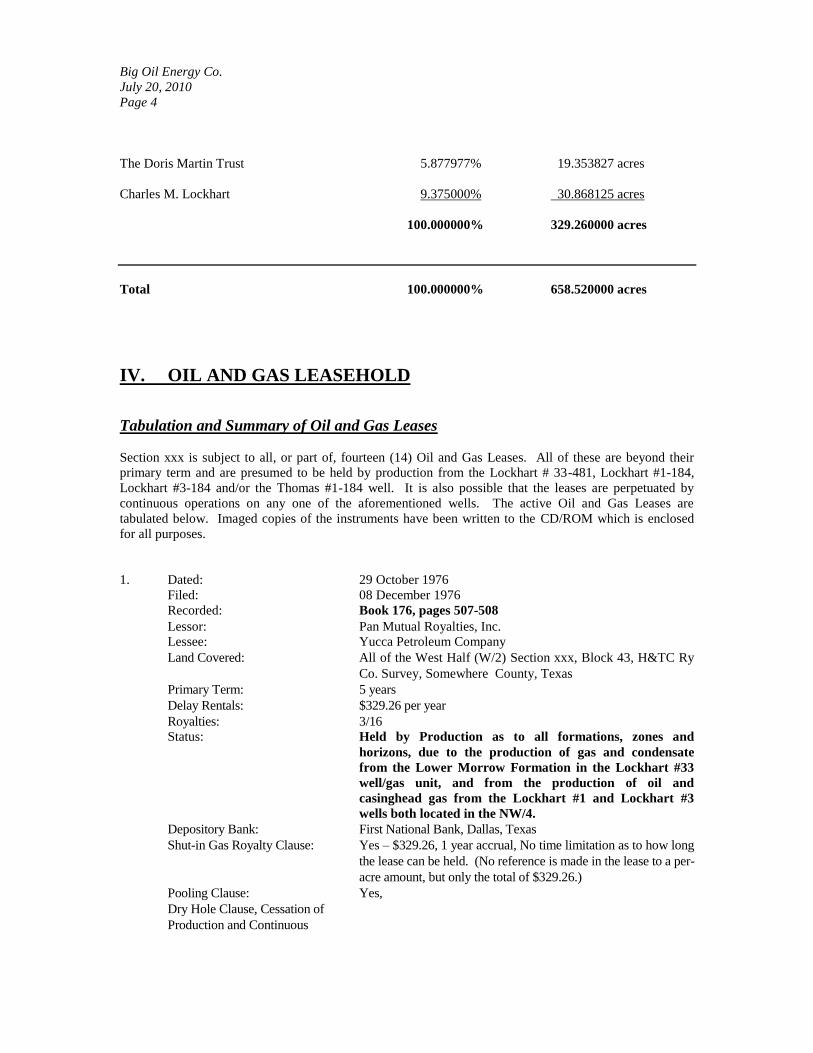
The Doris Martin Trust 5.877977% 19.353827 acres
Charles M. Lockhart 9.375000% 30.868125 acres
100.000000% 329.260000 acres
Total 100.000000% 658.520000 acres
IV. OIL AND GAS LEASEHOLD
Tabulation and Summary of Oil and Gas Leases
Section xxx is subject to all, or part of, fourteen (14) Oil and Gas Leases. All of these are beyond their
primary term and are presumed to be held by production from the Lockhart # 33-481, Lockhart #1-184,
Lockhart #3-184 and/or the Thomas #1-184 well. It is also possible that the leases are perpetuated by
continuous operations on any one of the aforementioned wells. The active Oil and Gas Leases are
tabulated below. Imaged copies of the instruments have been written to the CD/ROM which is enclosed
for all purposes.
1. Dated: 29 October 1976
Filed: 08 December 1976
Recorded: Book 176, pages 507-508
Lessor: Pan Mutual Royalties, Inc.
Lessee: Yucca Petroleum Company
Land Covered: All of the West Half (W/2) Section xxx, Block 43, H&TC Ry
Co. Survey, Somewhere County, Texas
Primary Term: 5 years
Delay Rentals: $329.26 per year
Royalties: 3/16
Status: Held by Production as to all formations, zones and
horizons, due to the production of gas and condensate
from the Lower Morrow Formation in the Lockhart #33
well/gas unit, and from the production of oil and
casinghead gas from the Lockhart #1 and Lockhart #3
wells both located in the NW/4.
Depository Bank: First National Bank, Dallas, Texas
Shut-in Gas Royalty Clause: Yes – $329.26, 1 year accrual, No time limitation as to how long
the lease can be held. (No reference is made in the lease to a per-
acre amount, but only the total of $329.26.)
Pooling Clause: Yes,
Dry Hole Clause, Cessation of
Production and Continuous

Big Oil Energy Co.
July 20, 2010
Page 5
Operations Clause: Yes – Operations must commence within 60 days from the
completion of any dry hole or cessation of production. Lease is
held in force as long as there is no cessation of production or
operations for more than 60 days on the lands covered by the
lease or any consolidated leasehold estate of which this lease is a
part. Notwithstanding any contrary provision herein, if
production results from operations, then the lease shall be held in
force so long as production continues.
Interest Covered: An undivided mineral interest equal to 164.63 net mineral acres.
Special Provisions: None
2. Dated: 05 October 1979
Filed: 03 December 1979
Recorded: Book 202, pages 488-493
Lessor: Estate of Carl H. Lockhart; Estate of Ben N. Lockhart;
Thomas Howard Lockhart, Sr.; Murl Lockhart Kenyon;
Charles Martin Lockhart; Thomas Howard Lockhart, Jr;
Robert William Lockhart; Albert Barton Lockhart, Jr.;
Elizabeth Lockhart Drury; Howard William Kenyon; Doris
Kenyon Martin
. Lessee: Kennedy & Mitchell, Inc.
Land Covered: All of the West Half (W/2) Section xxx, Block 43, H&TC Ry
Co. Survey, Somewhere County, Texas
Primary Term: 3 years
Delay Rentals: $329.26 per year
Royalties: 3/16
Status: Held by Production as to gas & condensate rights only in
the Lower Morrow formation due to production of gas and
condensate in the Lockhart #33 well/gas unit, and as to oil
rights only in the Tonkawa and Lower Morrow
Formations in the North Half of this tract due to the
production of oil and casinghead gas from the Lockhart #1
and Lockhart #3 wells.
Depository Bank: See Paragraph 11 of this Oil & Gas Lease
Shut-in Gas Royalty Clause: Yes – $329.26, 1 year accrual, 3 year limitation as per Paragraph
22 of the Addendum.
Pooling Clause: Yes – Gas and Condensate Only – See Special Provisions
Dry Hole Clause, Cessation of
Production and Continuous
Operations Clause: Yes – Operations must commence within 60 days from the
completion of any dry hole or cessation of production. Lease is
held in force as long as there is no cessation of production or
operations for more than 60 days on the lands covered by the
lease or any consolidated leasehold estate of which this lease is a
part. Notwithstanding any contrary provision herein, if
production results from operations, then the lease shall be held in
force so long as production continues.
Interest Covered: An undivided mineral interest equal to 164.63 net mineral acres.
Special Provisions: -Lease may only be pooled with other lands contained in
Section xxx .

Big Oil Energy Co.
July 20, 2010
Page 6
-Oil and casinghead gas cannot extend the lease as to gas and
condensate. Gas and condensate cannot extend the lease as to
oil and casinghead gas
-As of 01 January 1983, this lease terminated as to all
formations not producing within 60 days of the end of the
primary term.
-Lessee must obtain best purchase price of gas and
condensate. The Lease contains time limitations to do so.
-No use of fresh water for secondary recovery or water flood
operations. All water wells drilled must be left in place for
Lessor’s use when location is abandoned.
-Fresh water is NOT considered a mineral
-If royalty from production of well drops below $1080.00 for a
six (6) month period of time, Lessee must pay Lessors the
difference between production of well and $1080.00 upon
notification of such deficiency by Lessors. If such amount is
not paid, then the Lessee has 60 days to begin reworking
operations and/or drilling operation in an effort to bring
royalty back up to or beyond $1080.00. If such operations fail
to raise royalty above the $1080.00 then the lease terminates.
3. Dated: 05 October 1979
Filed: 03 December 1979
Recorded: Book 202, pages 494-499
Lessor: Estate of Carl H. Lockhart; Estate of Ben N. Lockhart;
Thomas Howard Lockhart, Sr.; Murl Lockhart Kenyon;
Charles Martin Lockhart; Thomas Howard Lockhart, Jr;
Robert William Lockhart; Albert Barton Lockhart, Jr.;
Elizabeth Lockhart Drury; Howard William Kenyon; Doris
Kenyon Martin
. Lessee: Kennedy & Mitchell, Inc.
Land Covered: All of the East Half (E/2) Section xxx, Block 43, H&TC Ry
Co. Survey, Somewhere County, Texas
Primary Term: 3 years
Delay Rentals: $329.26 per year
Royalties: 3/16
Status: Held by Production as to gas and condensate rights only in
the Lower Morrow Formation due to production of gas
and condensate from the Lockhart #33 well/gas unit.
Depository Bank: See Paragraph 11 of this Oil & Gas Lease
Shut-in Gas Royalty Clause: Same as Lease #2, supra.
Pooling Clause: Same as Lease #2, supra.
Dry Hole Clause, Cessation of
Production and Continuous
Operations Clause: Same as Lease #2, supra
Interest Covered: An undivided mineral interest equal to 329.26 net mineral acres.
Big Oil Energy Co.
July 20, 2010
Page 7
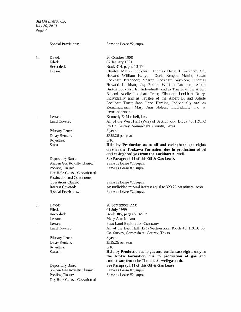
Special Provisions: Same as Lease #2, supra.
4. Dated: 26 October 1990
Filed: 07 January 1991
Recorded: Book 314, pages 10-17
Lessor: Charles Martin Lockhart; Thomas Howard Lockhart, Sr.;
Howard William Kenyon; Doris Kenyon Martin; Susan
Lockhart Braddock; Sharon Lockhart Seymore; Thomas
Howard Lockhart, Jr.; Robert William Lockhart; Albert
Barton Lockhart, Jr., Individually and as Trustee of the Albert
B. and Adelle Lockhart Trust; Elizabeth Lockhart Drury,
Individually and as Trustee of the Albert B. and Adelle
Lockhart Trust; Joan Ilene Harding, Individually and as
Remainderman; Mary Ann Nelson, Individually and as
Remainderman.
. Lessee: Kennedy & Mitchell, Inc.
Land Covered: All of the West Half (W/2) of Section xxx, Block 43, H&TC
Ry Co. Survey, Somewhere County, Texas
Primary Term: 3 years
Delay Rentals: $329.26 per year
Royalties: 3/16
Status: Held by Production as to oil and casinghead gas rights
only in the Tonkawa Formation due to production of oil
and casinghead gas from the Lockhart #1 well.
Depository Bank: See Paragraph 11 of this Oil & Gas Lease.
Shut-in Gas Royalty Clause: Same as Lease #2, supra.
Pooling Clause: Same as Lease #2, supra.
Dry Hole Clause, Cessation of
Production and Continuous
Operations Clause: Same as Lease #2, supra
Interest Covered: An undivided mineral interest equal to 329.26 net mineral acres.
Special Provisions: Same as Lease #2, supra.
5. Dated: 20 September 1998
Filed: 01 July 1999
Recorded: Book 385, pages 513-517
Lessor: Mary Ann Nelson
. Lessee: Strat Land Exploration Company
Land Covered: All of the East Half (E/2) Section xxx, Block 43, H&TC Ry
Co. Survey, Somewhere County, Texas
Primary Term: 3 years
Delay Rentals: $329.26 per year
Royalties: 3/16
Status: Held by Production as to gas and condensate rights only in
the Atoka Formation due to production of gas and
condensate from the Thomas #1 well/gas unit.
Depository Bank: See Paragraph 11 of this Oil & Gas Lease
Shut-in Gas Royalty Clause: Same as Lease #2, supra.
Pooling Clause: Same as Lease #2, supra.
Dry Hole Clause, Cessation of
Big Oil Energy Co.
July 20, 2010
Page 8
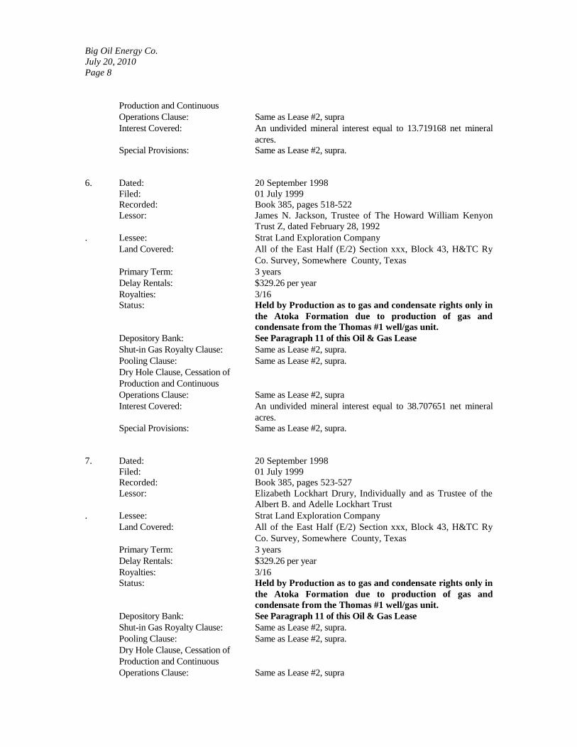
Production and Continuous
Operations Clause: Same as Lease #2, supra
Interest Covered: An undivided mineral interest equal to 13.719168 net mineral
acres.
Special Provisions: Same as Lease #2, supra.
6. Dated: 20 September 1998
Filed: 01 July 1999
Recorded: Book 385, pages 518-522
Lessor: James N. Jackson, Trustee of The Howard William Kenyon
Trust Z, dated February 28, 1992
. Lessee: Strat Land Exploration Company
Land Covered: All of the East Half (E/2) Section xxx, Block 43, H&TC Ry
Co. Survey, Somewhere County, Texas
Primary Term: 3 years
Delay Rentals: $329.26 per year
Royalties: 3/16
Status: Held by Production as to gas and condensate rights only in
the Atoka Formation due to production of gas and
condensate from the Thomas #1 well/gas unit.
Depository Bank: See Paragraph 11 of this Oil & Gas Lease
Shut-in Gas Royalty Clause: Same as Lease #2, supra.
Pooling Clause: Same as Lease #2, supra.
Dry Hole Clause, Cessation of
Production and Continuous
Operations Clause: Same as Lease #2, supra
Interest Covered: An undivided mineral interest equal to 38.707651 net mineral
acres.
Special Provisions: Same as Lease #2, supra.
7. Dated: 20 September 1998
Filed: 01 July 1999
Recorded: Book 385, pages 523-527
Lessor: Elizabeth Lockhart Drury, Individually and as Trustee of the
Albert B. and Adelle Lockhart Trust
. Lessee: Strat Land Exploration Company
Land Covered: All of the East Half (E/2) Section xxx, Block 43, H&TC Ry
Co. Survey, Somewhere County, Texas
Primary Term: 3 years
Delay Rentals: $329.26 per year
Royalties: 3/16
Status: Held by Production as to gas and condensate rights only in
the Atoka Formation due to production of gas and
condensate from the Thomas #1 well/gas unit.
Depository Bank: See Paragraph 11 of this Oil & Gas Lease
Shut-in Gas Royalty Clause: Same as Lease #2, supra.
Pooling Clause: Same as Lease #2, supra.
Dry Hole Clause, Cessation of
Production and Continuous
Operations Clause: Same as Lease #2, supra

Big Oil Energy Co.
July 20, 2010
Page 9
Interest Covered: An undivided mineral interest equal to 19.353824 net mineral
acres.
Special Provisions: Same as Lease #2, supra.
8. Dated: 20 September 1998
Filed: 01 July 1999
Recorded: Book 385, pages 528-532
Lessor: Albert Barton Lockhart, Jr., Individually and as Trustee of the
Albert B. and Adelle Lockhart Trust
. Lessee: Strat Land Exploration Company
Land Covered: All of the East Half (E/2) Section xxx, Block 43, H&TC Ry
Co. Survey, Somewhere County, Texas
Primary Term: 3 years
Delay Rentals: $329.26 per year
Royalties: 3/16
Status: Held by Production as to gas and condensate rights only in
the Atoka Formation due to production of gas and
condensate from the Thomas #1 well/gas unit.
Depository Bank: See Paragraph 11 of this Oil & Gas Lease
Shut-in Gas Royalty Clause: Same as Lease #2, supra.
Pooling Clause: Same as Lease #2, supra.
Dry Hole Clause, Cessation of
Production and Continuous
Operations Clause: Same as Lease #2, supra
Interest Covered: An undivided mineral interest equal to 19.353824 net mineral
acres.
Special Provisions: Same as Lease #2, supra.
9. Dated: 20 September 1998
Filed: 01 July 1999
Recorded: Book 385, pages 533-537
Lessor: Robert William Lockhart
. Lessee: Strat Land Exploration Company
Land Covered: All of the East Half (E/2) Section xxx, Block 43, H&TC Ry
Co. Survey, Somewhere County, Texas
Primary Term: 3 years
Delay Rentals: $329.26 per year
Royalties: 3/16
Status: Held by Production as to gas and condensate rights only in
the Atoka Formation due to production of gas and
condensate from the Thomas #1 well/gas unit.
Depository Bank: See Paragraph 11 of this Oil & Gas Lease
Shut-in Gas Royalty Clause: Same as Lease #2, supra.
Pooling Clause: Same as Lease #2, supra.
Dry Hole Clause, Cessation of
Production and Continuous
Operations Clause: Same as Lease #2, supra
Interest Covered: An undivided mineral interest equal to 38.707648 net mineral
acres.
Special Provisions: Same as Lease #2, supra.

Big Oil Energy Co.
July 20, 2010
Page 10
10. Dated: 20 September 1998
Filed: 01 July 1999
Recorded: Book 385, pages 538-542
Lessor: Sharon Lockhart Seymore
. Lessee: Strat Land Exploration Company
Land Covered: All of the East Half (E/2) Section xxx, Block 43, H&TC Ry
Co. Survey, Somewhere County, Texas
Primary Term: 3 years
Delay Rentals: $329.26 per year
Royalties: 3/16
Status: Held by Production as to gas and condensate rights only in
the Atoka Formation due to production of gas and
condensate from the Thomas #1 well/gas unit.
Depository Bank: See Paragraph 11 of this Oil & Gas Lease
Shut-in Gas Royalty Clause: Same as Lease #2, supra.
Pooling Clause: Same as Lease #2, supra.
Dry Hole Clause, Cessation of
Production and Continuous
Operations Clause: Same as Lease #2, supra
Interest Covered: An undivided mineral interest equal to 3.919761 net mineral
acres.
Special Provisions: Same as Lease #2, supra.
11. Dated: 20 September 1998
Filed: 01 July 1999
Recorded: Book 385, pages 543-547
Lessor: Susan Lockhart Braddock
. Lessee: Strat Land Exploration Company
Land Covered: All of the East Half (E/2) Section xxx, Block 43, H&TC Ry
Co. Survey, Somewhere County, Texas
Primary Term: 3 years
Delay Rentals: $329.26 per year
Royalties: 3/16
Status: Held by Production as to gas and condensate rights only in
the Atoka Formation due to production of gas and
condensate from the Thomas #1 well/gas unit.
Depository Bank: See Paragraph 11 of this Oil & Gas Lease
Shut-in Gas Royalty Clause: Same as Lease #2, supra.
Pooling Clause: Same as Lease #2, supra.
Dry Hole Clause, Cessation of
Production and Continuous
Operations Clause: Same as Lease #2, supra
Interest Covered: An undivided mineral interest equal to 3.919761 net mineral
acres.
Special Provisions: Same as Lease #2, supra.

Big Oil Energy Co.
July 20, 2010
Page 11
12. Dated: 20 September 1998
Filed: 01 July 1999
Recorded: Book 385, pages 548-552
Lessor: Doris Kenyon Martin , Individually and as Trustee of the
Doris Martin Trust dated January 15, 1996, by Karen K.
Martin, her attorney-in-fact.
. Lessee: Strat Land Exploration Company
Land Covered: All of the East Half (E/2) Section xxx, Block 43, H&TC Ry
Co. Survey, Somewhere County, Texas
Primary Term: 3 years
Delay Rentals: $329.26 per year
Royalties: 3/16
Status: Held by Production as to gas and condensate rights only in
the Atoka Formation due to production of gas and
condensate from the Thomas #1 well/gas unit.
Depository Bank: See Paragraph 11 of this Oil & Gas Lease
Shut-in Gas Royalty Clause: Same as Lease #2, supra.
Pooling Clause: Same as Lease #2, supra.
Dry Hole Clause, Cessation of
Production and Continuous
Operations Clause: Same as Lease #2, supra
Interest Covered: An undivided mineral interest equal to 38.707651 net mineral
acres.
Special Provisions: Same as Lease #2, supra.
13. Dated: 20 September 1998
Filed: 01 July 1999
Recorded: Book 385, pages 728-732
Lessor: Charles M. Lockhart; Thomas Howard Lockhart, Sr.; Thomas
Lockhart, Jr.
. Lessee: Strat Land Exploration Company
Land Covered: All of the East Half (E/2) Section xxx, Block 43, H&TC Ry
Co. Survey, Somewhere County, Texas
Primary Term: 3 years
Delay Rentals: $329.26 per year
Royalties: 3/16
Status: Held by Production as to gas and condensate rights only in
the Atoka Formation due to production of gas and
condensate from the Thomas #1 well/gas unit.
Depository Bank: See Paragraph 11 of this Oil & Gas Lease
Shut-in Gas Royalty Clause: Same as Lease #2, supra.
Pooling Clause: Same as Lease #2, supra.
Dry Hole Clause, Cessation of
Production and Continuous
Operations Clause: Same as Lease #2, supra
Interest Covered: An undivided mineral interest equal to 100.443898 net mineral
acres.
Special Provisions: Same as Lease #2, supra.

Big Oil Energy Co.
July 20, 2010
Page 12
14. Dated: 01 March 2000
Filed: 03 April 2000
Recorded: Book 391, pages 224-226
Lessor: Peyton Oil & Gas, Inc.
. Lessee: Strat Land Exploration Company
Land Covered: All of the East Half (E/2) Section xxx, Block 43, H&TC Ry
Co. Survey, Somewhere County, Texas
Primary Term: 18 months
Delay Rentals: Paid-up Lease, None during the primary term. $10.00 per acre
with a 1 accrual period after the end of the primary term.
Royalties: 1/5
Status: Held by Production as to gas and condensate rights only in
the Atoka Formation due to production of gas and
condensate from the Thomas #1 well/gas unit.
Depository Bank: None- Pay Lessor Directly
Shut-in Gas Royalty Clause: $10.00 per acre with a 1 year accrual period after the end of the
primary term.
Pooling Clause: None – Pooling Clause was marked out by Lessor
Dry Hole Clause, Cessation of
Production and Continuous
Operations Clause: Same as Lease #2, supra
Interest Covered: An undivided mineral interest equal to 13.719168 net mineral
acres.
Special Provisions: -Lessee is required to give written notice of commencement,
completion, reworking or abandonment of any well drilled,
mailing said notice ten (10) days prior to each such activity
previously listed. Lessor has the right to inspect the well(s) and
have an authorized agent present during operations. Lessor has
the right to inspect all cores, samples, and logs. All
representatives of Lessor will be authorized in writing.
-All of Lessee’s property not removed within 90 days of the
termination of this lease shall become the property of Lessor.
-Lessor has thirty (30) days from the date Lessee decides to
abandon any well drilled on the leased premises to elect to
purchase said well and all associated equipment.
-As of September 20, 2002 all non-producing zones were to be
released. The zone in which a shut-in gas well capable of
producing gas in paying quantities has been completed is
considered, by the terms of the Lease, to be a producing zone.
-Distillate and condensate are to be extracted by mechanical
means and considered to be oil.
-At the time of termination of any part of this Lease, Lessee, its
successor’s and assigns are required to execute, acknowledge
and file for record a release of all rights which have terminated
under the provisions of this Lease

Big Oil Energy Co.
July 20, 2010
Page 13
-Lessor reserves unto itself all minerals other than oil, gas,
casinghead gas, condensate, other liquid and gaseous
hydrocarbons, and other minerals produced in association with
such oil, gas, and other hydrocarbons.
-If Lease is assigned by the operator, the new operator is
required to pay all royalties, delay rentals, etc. Lessee is required
to pay 1.5% interest on any incorrect payment of royalties after
ninety (90) days from the date of first production.
-Minimum royalty requirement of $3,292.60.
Summary of Interest in Oil and Gas Leasehold
Tract 1: All of Section xxx, Block 43, H&TC Ry. Co. Survey, Somewhere County, Texas,
containing 658.52 acres, more or less, LIMITED TO production of GAS AND CONDENSATE ONLY
from the Lower Morrow Formation, which is being produced from the 658.52-acre pooled unit for the
Lockhart # 33-481 well located 1348΄ FWL & 1328΄ FNL of the lease lines, being all of the East Half
(E/2) of Section xxx and producing from the Lower Morrow Formation (Leases tabulated as nos. 1-3,
supra.)
Owner
Type
Leases
Calculations
Net Revenue
Interest
Total Royalty 18.750000%
William E. Hulsizer Trust ORRI 1-3 0.250000% x 100%
0.250000%
Phyllis N. Hulsizer ORRI 1-3 0.250000% x 100%
0.250000%
Kenneth L. Peters ORRI 1-3 0.250000% x 100%
0.250000%
Ruth L. Peters ORRI 1-3 0.250000% x 100%
0.250000%
George F. Maddox & Co. ORRI 1-3 0.500000% x 100%
0.500000%
Robert C. Eckert ORRI 1 1.5% x 1.562500% x 25%
0.005859%
Mexia Holdings
ORRI 1 0.769531% x 25% 0.192383%
Monarch Holdings, Inc.
ORRI 1 0.769531% x 25% 0.192383%
Gene Edwards ORRI 1 0.50000% x 25%
0.125000%
William T. Griffin ORRI 1 0.250000% x 25%
0.062500%
Eugene McCart Estate ORRI 1 3.750000% x 1.562500% x
50%
0.035596%

Big Oil Energy Co.
July 20, 2010
Page 14
R. T. McLain ORRI 1 5.625088% x 1.562500% x
25%
0.021973%
J. F. Messenbaugh ORRI 1 5.625088% x 1.562500% x
25%
0.021973%
Gordon D. Williams ORRI 1 6.749952% x 1.562500% x
25%
0.026367%
McGoo, Ltd. ORRI 1 64.637440% x 1.562500% x
25%
0.252490%
Klingensmith Family
Partnership
ORRI 1 3.749888% x 1.562500% x
25%
0.014648%
John Croft ORRI 1-3 (1% x 15.666526%) + (1% x
15.251260%) + (1% x
6.291527%)
0.372093%
Larry B. Darden, Agent ORRI 1-3 (0.5% x 15.666526%) + (0.5%
x 15.251260%) + (0.5% x
6.291527%)
0.186047%
CTJ Company, a Texas
partnership
ORRI 1 8.125000% x 25% 2.031250%
Elizabeth Herring Estate, a
Texas GP
(Taylor/Herring Co.) – See
Recommended Title Curative #9
ORRI 1 0.500000% x 25% 0.125000%
Drury Oil Properties, LC
(Osage Oil & Gas Company) –
See Recommended Title Curative
#9
ORRI 1 4.499968% x 1.562500% x
25%
0.017578%
Total ORRI
5.183140%
PPC Anadarko, Inc. WI 1-3 6.250000% x 76.625% Eff
NRI
4.789063%
Cabot Oil & Gas Corporation WI 1-3 46.958053% WI x 76.625%
Eff NRI
35.981608%
Armstrong Children’s Trust WI 1-3 1.562500% WI x 76.625% Eff
NRI
1.197266%
L. A. Idler & Floyd Murray
d/b/a Idler & Murray
WI 1-3 3.125000% WI x 76.625% Eff
NRI
2.394531%

Big Oil Energy Co.
July 20, 2010
Page 15
Farleigh Oil Properties WI 1-3 1.562500% WI x 76.625% Eff
NRI
1.197266%
Harry A. Rider WI 1-3 3.125000% x 76.625% Eff
NRI
2.394531%
Paul Elliot WI 1-3 .207634% x 76.625% Eff NRI
0.159099%
Strat Land Exploration Co. WI 1-3 37.209313% x 75.125% Eff
NRI
27.953496%
Total WI
76.066860%
Total
100.000000%
Tract 2: All of the NW/4 of Section xxx, Block 43, H&TC Ry Co. Survey, Somewhere County,
Texas, containing163.13 acres, more or less, LIMITED TO the wellbore only of the Strat Land Lockhart
#1-184 oil well located 1300΄FNL & 1700΄ FWL of Section xxx, and FURTHER LIMITED TO
production of oil and casinghead gas from the Tonkawa Formation (Leases tabulated as nos. 1 and 4,
supra.) -- (See Recommended Title Curative #s 12 and 13, infra)
Owner Type Leases Calculations Net Revenue
Interest
Total Royalty 18.750000%
William E. Hulsizer Trust
ORRI 1 0.250000% x 50% 0.125000%
Phyllis N. Hulsizer
ORRI 1 0.250000% x 50% 0.125000%
Kenneth L. Peters
ORRI 1 0.250000% x 50% 0.125000%
Ruth L. Peters
ORRI 1 0.250000% x 50% 0.125000%
George F. Maddox & Co.
ORRI 1 0.500000% x 50% 0.250000%
Robert C. Eckert
ORRI 1 1.5% x 1.562500% x 50% 0.011719%
Mexia Holdings
ORRI 1 0.769531% x 50% 0.384766%
Monarch Holdings, Inc.
ORRI 1 0.769531% x 50% 0.384765%
Gene Edwards
ORRI 1 0.500000% x 50% 0.250000%

Big Oil Energy Co.
July 20, 2010
Page 16
Elizabeth Herring Estate, a
Texas GP (Taylor/Herring Co.)
– See Recommended Title
Curative #9
ORRI 1 0.500000% x 50%
0.250000%
William T. Griffin
ORRI 1 0.250000% x 50% 0.125000%
CTJ Company
ORRI 1 8.125000% x 50% 4.062500%
Eugene McCart (Eugene
McCart Estate) See
Recommended Title Curative #s
10 & 11
ORRI 1 9.112576% x 1.562500% x
50%
0.071192%
R. T. McLain See
Recommended Title Curative #
11
ORRI 1 5.625088% x 1.562500% x
50%
0.043946%
J. F. Messenbaugh See
Recommended Title Curative #
11
ORRI 1 5.625088% x 1.562500% x
50%
0.043946%
Gordon D. Williams See
Recommended Title Curative #
11
ORRI 1 6.749952% x 1.562500% x
50%
0.052734%
McGoo, Ltd. See Recommended
Title Curative # 11
ORRI 1 64.637440% x 1.562500% x
50%
0.504980%
Drury Oil Properties, LC See
Recommended Title Curative #
11
ORRI 1 4.499968% x 1.562500% x
50%
0.035156%
Klingensmith Family
Partnership See Recommended
Title Curative #11
ORRI 1 3.749888% x 1.562500% x
50%
0.029296%
John Croft
ORRI 4 1.5% x 50% 0.750000%
Larry Darden, as Agent for
Strat Land Exploration
Incentive Plan
ORRI 4 0.5% x 50% 0.250000%
WONTOK-II Royalty Co. ORRI 1 & 4 (25% x 2% x 50%) + (2% x
14.515159% x 2% x 50%)
0.395152%
Chesapeake ORC, LLC ORRI 1 & 4 (1% x 11.484374% x 50%)
+ (1% x 6.667901% x 50%)
0.090761%
Stephen G. Vedros ORRI 1 & 4 (0.5% x 25% x 50%) +
(0.5% x 14.515159% x
50%)
0.098787%

Big Oil Energy Co.
July 20, 2010
Page 17
Total ORRI 8.584700%
Darden Resources, Inc. WI 1 & 4 51.127613%
37.401263%
Abraxas Operating, LLC WI 1 & 4 12.607805%
9.101478%
Cabot Oil & Gas Corporation WI 1 7.031250%
4.728516%
Aeneas Energy Corp. WI 1 0.234375%
0.157617%
Princeton Energy, LLC WI 1 & 4 0.197575%
0.140954%
PPC Anadarko, Inc. WI 1 3.125000%
2.101563%
B&K Resources, Inc. WI 1 & 4 5.136971%
3.844613%
Axis Energy Corporation WI 1 & 4 8.693335%
6.506268%
Vrooman Energy, LLC WI 1 & 4 0.197576%
0.147870%
WillisChild Oil & Gas, Inc. WI 1 & 4 0.493939%
0.369674%
Eddie Haynes Trust WI 1 & 4 0.493939%
0.369674%
Jones County Minerals, Inc. WI 1 & 4 3.951516%
2.957394%
LewAnn, Ltd. WI 1 & 4 3.951516%
2.957394%
G. Russell McGhee & Francis
R. McGhee, JT w/ ROS
WI 1 & 4 0.296364%
0.221805%
Paul C. Elliott WI 1 0.015573%
0.010473%
John L. Hern WI 1 0.003115%
0.002095%
Harry A. Rider WI 1 1.562500%
1.050781%
Armstrong Children’s Trust WI 1 0.78125%
0.525391%
Joseph J. Morelli WI 1 & 4 0.098788%
0.070477%
Total WI 72.6653%
Total
100.000000%

Big Oil Energy Co.
July 20, 2010
Page 18
Tract 3: All of the NW/4 of Section xxx, Block 43, H&TC Ry. Co. Survey, Somewhere County,
Texas, containing 163.13 acres, more or less, LESS & EXCEPT the wellbore of the Strat Land Lockhart
#1-184 oil well (Leases tabulated nos.1 and 4, supra.) AND LIMITED TO THE DEPTHS BETWEEN
THE SURFACE AND 7,600’ - See Recommended Title Curative #8, infra.
Owner Type Leases Calculations Net Revenue
Interest
Total Royalty
18.750000%
William E. Hulsizer Trust
ORRI 1 0.250000% x 50% 0.125000%
Phyllis N. Hulsizer
ORRI 1 0.250000% x 50% 0.125000%
Kenneth L. Peters
ORRI 1 0.250000% x 50% 0.125000%
Ruth L. Peters
ORRI 1 0.250000% x 50% 0.125000%
George F. Maddox & Co.
ORRI 1 0.500000% x 50% 0.250000%
Robert C. Eckert
ORRI 1 1.5% x 1.562500% x 50% 0.011719%
Mexia Holdings
ORRI 1 0.769531% x 50% 0.384766%
Monarch Holdings, Inc.
ORRI 1 0.769531% x 50% 0.384765%
Gene Edwards
ORRI 1 0.500000% x 50% 0.250000%
Elizabeth Herring Estate, a
Texas GP(Taylor/Herring Co.) –
See Recommended Title Curative
#9
ORRI 1 (0.500000% x 50%) 0.250000%
William T. Griffin
ORRI 1 (0.250000% x 50%) + 0.125000%
CTJ Company, a Texas
Partnership
ORRI 1 (8.125000% x 50%) 4.062500%
Eugene McCart Estate
ORRI 1 9.112576% x 1.562500% x
50%
0.071192%
R. T. McLain ORRI 1 5.625088% x 1.562500% x
50%
0.043946%
J. F. Messenbaugh ORRI 1 5.625088% x 1.562500% x
50%
0.043946%
Gordon D. Williams ORRI 1 6.749952% x 1.562500% x
50%
0.052734%
McGoo, Ltd. ORRI 1 64.637440% x 1.562500% x
50%
0.504980%

Big Oil Energy Co.
July 20, 2010
Page 19
Drury Oil Properties, LC
(Osage Oil & Gas Company) –
See Recommended Title Curative
#9
ORRI 1 4.499968% x 1.562500% x
50%
0.035156%
Klingensmith Family
Partnership
ORRI 1 3.749888% x 1.562500% x
50%
0.029296%
John Croft
ORRI 4 1.5% x 50% 0.750000%
Larry Darden, Agent
ORRI 4 0.5% x 50% 0.250000%
Total ORRI
8.000000%
PPC Anadarko, Inc. WI 1 3.125000 %
2.101562%
Harold T. Wright WI 1 0.041527 %
0.027926%
Cabot Oil & Gas Corporation
WI 1 4.687500%
3.152344%
Strat Land Exploration
Company
WI 1 3.125000 %
2.101563%
L.A. Idler & Floyd Murray
d/b/a Idler & Murray
WI 1 1.562500 %
1.050781%
Harry A. Rider WI 1 1.562500 %
1.050781%
Douglas H. Wilson Revocable
Trust
WI 1 1.562500 %
1.050781%
Armstrong Children’s Trust WI 1 0.781250%
0.525391%
Bill D. Farleigh Revocable
Trust (See Recommended Title
Curative #2)
WI 1 0.781250%
0.525391%
Darden Resources, Inc. WI 1 & 4 45.200711%
33.674041%
Abraxas Operating, LLC WI 1 & 4 13.256289%
9.875792%
B&K Resources, Inc. WI 1 & 4 5.380113/%
4.008125%
Axis Energy Corporation WI 1 & 4 9.104807%
6.782983%
Vrooman Energy, LLC WI 1 & 4 0.206927%
0.154159%
WillisChild Oil & Gas, Inc. WI 1 & 4 0.517318%
0.385397%
Eddie Haynes Trust WI 1 & 4 0.517319%
0.385397%

Big Oil Energy Co.
July 20, 2010
Page 20
Jones County Minerals, Inc.
WI 1 & 4 4.138549%
3.083174%
LewAnn, Ltd. WI 1 & 4 4.138549%
3.083174%
G. Russell McGhee & Francis
R. McGhee, JT w/ ROS
WI 1 & 4 0.310391%
0.231238%
Total WI
100.000000% 73.250000%
Total
100.000000%
Tract 4: All of the NW/4 of Section xxx, Block 43, H&TC Ry. Co. Survey, Somewhere County,
Texas, containing 163.13 acres, more or less, LESS & EXCEPT the wellbore of the Strat Land Lockhart
#1 oil well (Leases tabulated as nos. 1 and 4, supra.) AND LIMITED TO DEPTHS BELOW THE
DEPTH OF 7,600’ SAVE & EXCEPT THE LOWER MORROW FORMATION – See Recommended
Title Curative #8, infra.
Owner Type Leases Calculations Net Revenue
Interest
Lockhart Family Interest Open &
Unleased
95.833333% x 50% 47.916667%
Peyton Oil & Gas, Inc Open &
Unleased
4.166667% x 50% 2.083333%
Total Open & Unleased
50.000000%
Heritage Royalties, Inc.
1 50.000000% x 18.75% RI 9.375000%
Total Owner RI 1 18.75% x 50% 9.375000%
William E. Hulsizer Trust
ORRI 1 0.250000% x 50% 0.125000%
Phyllis N. Hulsizer
ORRI 1 0.250000% x 50% 0.125000%
Kenneth L. Peters
ORRI 1 0.250000% x 50% 0.125000%
Ruth L. Peters
ORRI 1 0.250000% x 50% 0.125000%
George F. Maddox & Co.
ORRI 1 0.500000% x 50% 0.250000%
Robert C. Eckert
ORRI 1 0.023438% x 50% 0.011719%
Mexia Holdings
ORRI 1 0.769531% x 50% 0.384766%

Big Oil Energy Co.
July 20, 2010
Page 21
Monarch Holdings, Inc.
ORRI 1 0.769531% x 50% 0.384765%
Gene Edwards
ORRI 1 0.500000% x 50% 0.250000%
Elizabeth Herring Estate, a
Texas GP (Taylor/Herring Co.)
– See Recommended Title
Curative #9
ORRI 1 0.500000% x 50% 0.250000%
William T. Griffin
ORRI 1 0.250000% x 50% 0.125000%
CTJ Company, a Texas
Partnership
ORRI 1 8.125000% x 50% 4.062500%
Eugene McCart Estate ORRI 1 9.112576%% x 1.562500%
x 50%
0.071192%
R. T. McLain ORRI 1 5.625088% x 1.562500% x
50%
0.043946%
J. F. Messenbaugh ORRI 1 5.625088% x 1.562500% x
50%
0.043946%
Gordon D. Williams ORRI 1 6.749952% x 1.562500% x
50%
0.052734%
McGoo, Ltd. ORRI 1 64.637440% x 1.562500% x
50%
0.504980%
Drury Oil Properties, LLC
(Osage Oil & Gas Company) –
See Recommended Title Curative
#9
ORRI 1 4.499968% x 1.562500% x
50%
0.035156%
Klingensmith Family
Partnership
ORRI 1 3.749888% x 1.562500% x
50%
0.029296%
Total ORRI
1 7.000000%
PPC Anadarko, Inc.
WI 1 6.250000% x 67.25% x 50% 2.101563%
Darden Resources, Inc
WI 1 8.555392% x 50% x 67.25% 2.876751%
Cabot Oil & Gas Corporation
WI 1 43.75% x 50% x 67.25% 14.710937%
Armstrong Children’s Trust
WI 1 1.562500% x 50% x 67.25% 0.525391%
L.A. Idler & Floyd Murray
d/b/a Idler & Murray
WI 1 3.125% x 50% x 67.25% 1.050781%

Big Oil Energy Co.
July 20, 2010
Page 22
Douglas H. Wilson Revocable
Trust
WI 1 3.125% x 50% x 67.25% 1.050781%
Bill D. Farleigh Revocable
Trust
WI 1 1.562500% x 50% x 67.25% 0.525391%
Harold T. Wright
WI 1 0.083052% x 50% x 67.25% 0.027926%
Paul C. Elliot
WI 1 0.207634% x 50% x 67.25% 0.069817%
John L. Hern
WI 1 0.041528% x 50% x 67.25% 0.013964%
Abraxas Operating, LLC
WI 1 2.509092% x 50% x 67.25% 0.843682%
G. Russell McGhee & Francis
R. McGhee, JT w/ ROS
WI 1 0.058750% x 50% x 67.25% 0.019755%
B&K Resources, Inc.
WI 1 1.018324% x 50% x 67.25% 0.342411%
Axis Energy Corporation
WI 1 1.723318% x 50% x 67.25% 0.579466%
Vrooman Energy, LLC
WI 1 0.039166% x 50% x 67.25% 0.013170%
WillisChild Oil & Gas, Inc.
WI 1 0.097916% x 50% x 67.25% 0.032924%
Eddie Haynes Trust
WI 1 0.097916% x 50% x 67.25% 0.032924%
Jones County Minerals, Inc
WI 1 0.783326% x 50% x 67.25% 0.263393%
LewAnn, Ltd
WI 1 0.783326% x 50% x 67.25% 0.263393%
Strat Land Exploration
Company
WI 1 21.50126% x 50% x 67.25% 7.229799%
Harry A. Rider
WI 1 3.125% x 50% x 67.25% 1.050781%
Total WI 33.625000%
Total
100.000000%

Big Oil Energy Co.
July 20, 2010
Page 23
Tract 5: All of the SW/4 of Section xxx, Block 43, H&TC Ry. Co. Survey, Somewhere County,
Texas, containing 163.13 acres, more or less, (Leases tabulated as nos. 1 and 4, supra) SAVE &
EXCEPT the Gas and Condensate rights from the Lower Morrow Formation.
Owner Type Leases Calculations Net Revenue
Interest
Lockhart Family Interest Open &
Unleased
95.833333% x 50% 47.916667%
Peyton Oil & Gas, Inc Open &
Unleased
4.166667% x 50% 2.083333%
Total Open & Unleased 50.000000%
Heritage Royalties, Inc.
1
50% x 18.75%
9.375000%
Total Owner RI
1 18.75% x 50% 9.375000%
William E. Hulsizer Trust
ORRI 1 0.250000% x 50% 0.125000%
Phyllis N. Hulsizer
ORRI 1 0.250000% x 50% 0.125000%
Kenneth L. Peters
ORRI 1 0.250000% x 50% 0.125000%
Ruth L. Peters
ORRI 1 0.250000% x 50% 0.125000%
George F. Maddox & Co.
ORRI 1 0.500000% x 50% 0.250000%
Robert C. Eckert
ORRI 1 0.023438% x 50% 0.011719%
Mexia Holdings
ORRI 1 0.769531% x 50% 0.384766%
Monarch Holdings, Inc.
ORRI 1 0.769531% x 50% 0.384765%
Gene Edwards
ORRI 1 0.500000% x 50% 0.250000%
Elizabeth Herring Estate, a
Texas GP (Taylor/Herring Co.)
– See Recommended Title
Curative #9
ORRI 1 0.500000% x 50% 0.250000%
William T. Griffin
ORRI 1 0.250000% x 50% 0.125000%
CTJ Company, a Texas
Partnership
ORRI 1 8.125000% x 50% 4.062500%
Eugene McCart Estate
ORRI 1 9.112576%% x 1.562500%
x 50%
0.071192%

Big Oil Energy Co.
July 20, 2010
Page 24
R. T. McLain ORRI 1 5.625088% x 1.562500% x
50%
0.043946%
J. F. Messenbaugh ORRI 1 5.625088% x 1.562500% x
50%
0.043946%
Gordon D. Williams ORRI 1 6.749952% x 1.562500% x
50%
0.052734%
McGoo, Ltd. ORRI 1 64.637440% x 1.562500% x
50%
0.504980%
Drury Oil Properties, LLC
(Osage Oil & Gas Company) –
See Recommended Title Curative
#9
ORRI 1 4.499968% x 1.562500% x
50%
0.035156%
Klingensmith Family
Partnership
ORRI 1 3.749888% x 1.562500% x
50%
0.029296%
Total ORRI
1 7.000000%
PPC Anadarko, Inc. WI 1 6.250000% x 67.25% x
50%
2.101563%
Darden Resources, Inc
WI 1 8.555392% x 50% x 67.25% 2.876751%
Cabot Oil & Gas Corporation
WI 1 43.75% x 50% x 67.25% 14.710937%
Armstrong Children’s Trust WI 1 1.562500% x 50% x
67.25%
0.525391%
L.A. Idler & Floyd Murray
d/b/a Idler & Murray
WI 1 3.125% x 50% x 67.25% 1.050781%
Douglas H. Wilson Revocable
Trust
WI 1 3.125% x 50% x 67.25% 1.050781%
Bill D. Farleigh Revocable
Trust
WI 1 1.562500% x 50% x 67.25% 0.525391%
Harold T. Wright
WI 1 0.083052% x 50% x 67.25% 0.027926%
Paul C. Elliot
WI 1 0.207634% x 50% x 67.25% 0.069817%
John L. Hern
WI 1 0.041528% x 50% x 67.25% 0.013964%
Abraxas Operating, LLC
WI 1 2.509092% x 50% x 67.25% 0.843682%
G. Russell McGhee & Francis
R. McGhee, JT w/ ROS
WI 1 0.058750% x 50% x 67.25% 0.019755%

Big Oil Energy Co.
July 20, 2010
Page 25
B&K Resources, Inc.
WI 1 1.018324% x 50% x 67.25% 0.342411%
Axis Energy Corporation
WI 1 1.723318% x 50% x 67.25% 0.579466%
Vrooman Energy, LLC
WI 1 0.039166% x 50% x 67.25% 0.013170%
WillisChild Oil & Gas, Inc.
WI 1 0.097916% x 50% x 67.25% 0.032924%
Eddie Haynes Trust
WI 1 0.097916% x 50% x 67.25% 0.032924%
Jones County Minerals, Inc
WI 1 0.783326% x 50% x 67.25% 0.263393%
LewAnn, Ltd
WI 1 0.783326% x 50% x 67.25% 0.263393%
Strat Land Exploration
Company
WI 1 21.50126% x 50% x 67.25% 7.229799%
Harry A. Rider
WI 1 3.125% x 50% x 67.25% 1.050781%
Total WI 33.625000%
Total
100.000000%
Tract 6: All of the E/2 of Section xxx, Block 43, H&TC Ry. Co. Survey, Somewhere County,
Texas, containing 326.26 acres, more or less, under Leases tabulated nos. 5-14, supra, LIMITED TO the
wellbore only of the Thomas #1 gas well/unit located 2100΄FSL and 467΄ FEL of Section xxx and
FURTHER LIMITED TO production of Gas and Condensate from the Atoka Formation.
Owner Type Leases Calculations Net Revenue
Interest
Total Royalty
18.802083%
Larry Darden, Agent
ORR 0.5% x 8/8ths 0.500000%
John Croft
ORR 1.5% x 8/8ths 1.500000%
Total ORRI
2.000000%
Stratton Gas Marketing, LLC
WI 5-14 1.5% x 79.197917% 1.187969%
Fossil, LLC
WI 5-14 1.5% x 79.197917% 1.187969%
Darden Resources, Inc.
WI 5-14 95.095% x 79.197917% 75.313259%

Big Oil Energy Co.
July 20, 2010
Page 26
G. Russell McGhee & Frances
McGhee, as their community
property
WI 5-14 0.85% WI x 79.197917% 0.673182%
Kathy L. Hall Trust dated 15
Feb 2005; Kathy L. Hall,
Trustee
WI 5-14 0.330000% x 79.197917% 0.261353%
Kelly Byram & Kelly Greene-
Byram, JTWROS
WI 5-14 0.350000% x 79.197917% 0.277193%
Bruce L. Carter
WI 5-14 0.375000% x 79.197917% 0.296992%
Total WI 79.197917%
Total
100.000000%
Tract 7: All of the E/2 of Section xxx, Block 43, H&TC Ry. Co. Survey, Somewhere County,
Texas, containing 326.26 acres, more or less, (Leases tabulated nos. 5-14, supra) SAVE & EXCEPT the
Thomas #1 well.
Owner Type Leases Calculations Net Revenue
Interest
Total Royalty
18.802083%
Total ORRI
0.000000%
Strat Land Exploration Co. WI 5-14 100% x 81.197917%
81.197917%
Total WI
81.197917%
Total
100.000000%
V. RECOMMENDED TITLE CURATIVE
1. There appears of record in the official property records, Somewhere County, Texas, two
assignments from a Mr. William R. Toller. The first of these is recorded at volume 327, pages
735-746 and is an assignment from Mr. Toller and other entities to Strat Land Exploration
Company. Mr. Toller and others collectively assign their interest in the Oil & Gas Lease tabulated
#1, supra and reserve unto themselves a 15.0% working interest to be divided according to the
chart on Exhibit “A” of the document. Exhibit “A” was not filed with the document, and up to

Big Oil Energy Co.
July 20, 2010
Page 27
that point there had been nothing of record to indicate that Mr. Toller had any interest in any
Lease, well or unit. Later Mr. Toller makes an assignment of all of his right, title an interest to
Cabot Oil & Gas Corporation (“Cabot”) recorded at volume 424, pages 178-186. Since Mr. Toller
remained a “stranger” to the chain of title, I did not convey any interest to Cabot from Mr. Toller.
Curative measures may be needed to determine if Mr. Toller actually received any interest in the
Leases, wells or unit herein described, and from whom he received it. The division of interests,
supra, will need to be modified should it be discovered that Mr. Toller actually owned an interest
in the Leases, wells or units described herein.
2. There appears of record in the official property records, Somewhere County, Texas, an
assignment, recorded at volume 323, page 553, from Bill D. Farleigh to the Bill D. Farleigh
Revocable Trust (“The Trust”) conveying all of his right, title and interest. While Mr. Farleigh
individually is a “stranger” to the chain, Farleigh Oil Properties is not, and it appears to be related
to Mr. Farleigh. Later, The Trust conveys all of its right, title and interest in and to the Lockhart
#1 well to Strat Land Exploration Company (“Strat”) in an assignment recorded at volume 343,
page 225. Finally, Strat gives Darden Resources, Inc (“Darden”). a wellbore assignment in the
same well in an assignment recorded at volume 404, page 83. Since there was no indication that
Farleigh Oil Properties was anything other than a DBA, in my notes I conveyed the interest into
Darden. Curative measures may be necessary to ensure that Mr. Farleigh, individually, had clear
title to the interest conveyed to The Trust and the interest in the wellbore of the Lockhart #1 well
finally conveyed to Darden.
3. There appears of record in the official property records, Somewhere County, Texas, an
assignment, recorded at volume 333, page 488, from M.J. Armstrong to the Armstrong Children’s
Trust (“the Trust”) conveying “an undivided 100% interest” in the Oil and Gas Leases recorded at
volume 176, page 507; volumes 202, page 488; and volume 202, page 494. There are two issues
that arise from this assignment. The first is that Mr. Armstrong did not own an undivided 100% of
the aforementioned Oil and Gas Leases. In my notes, 100% of Mr. Armstrong’s right, title and
interest was conveyed to the Trust; however, since Mr. Armstrong conveyed a greater interest than
he actually owned, any future assignments conveying interest to Mr. Armstrong should
automatically be assigned to the Trust. The second issue is that prior to this assignment, there was
nothing of record assigned to an M.J. Armstrong, but only to a Mike Armstrong. It seemed to me
that M.J. Armstrong and Mike Armstrong were one and the same individual, so I conveyed the
interest previously held by Mike Armstrong to the Trust in this assignment. Curative measures,
such as an Affidavit of Identity, may be necessary.
4. There appears of record in the official property records, Somewhere County, Texas, an
assignment recorded at volume 389, page 746, from Larry Bryan Darden, II to Stratton Gas
Marketing, LLC (“Stratton”). It is clear that Mr. Darden is a relative of Larry B. Darden, who is
the owner of Darden Resources, Inc., Strat Land Exploration Co. and other entities within the
chain of title. Unfortunately, there is nothing of record conveying any interest in the Leases, wells
or units to Larry Bryan Darden, II making him a stranger to the chain of title. Since Mr. Darden is
a stranger to the chain of title, I did not convey any interest into Stratton in my notes. Curative
measures may be needed to determine if Mr. Darden actually received any interest in the Leases,
wells or unit herein described, and from whom he received it. The division of interests, supra, will
need to be modified should it be discovered that Mr. Darden actually owned an interest in the
Leases, wells or units described herein.
5. There appears of record in the official property records, Somewhere County, Texas, an
assignment recorded at volume 389, page 753, from John Christopher Darden to Fossil, LLC
(“Fossil”). It is clear that Mr. Darden is a relative of Larry B. Darden, who is the owner of Darden
Resources, Inc., Strat Land Exploration Co. and other entities within the chain of title.

Big Oil Energy Co.
July 20, 2010
Page 28
Unfortunately, there is nothing of record conveying any interest in the Leases, wells or units to
John Christopher Darden making him a stranger to the chain of title. Since Mr. Darden is a
stranger to the chain of title, I did not convey any interest into Fossil in my notes. Curative
measures may be needed to determine if Mr. Darden actually received any interest in the Leases,
wells or unit herein described, and from whom he received it. The division of interests, supra, will
need to be modified should it be discovered that Mr. Darden actually owned an interest in the
Leases, wells or units described herein.
6. There appears of record in the official property records, Somewhere County, Texas, an
assignment recorded at volume 319, page 219, from Strat Land Exploration Company (“Strat”) to
John Croft. This assignment conveys an ORRI equal to 0.5% of Strat’s right, title and interest in
and to the Oil and Gas Leases listed on Exhibit “A” of the document, limited to the production of
hydrocarbons from the well bore of the Thomas #1 well only. The Leases listed on the
aforementioned Exhibit “A” are the same leases associated with the Lockhart #33 well which are
held as to the Lower Morrow Formation only. According to completion and production reports
from the Texas Railroad Commission website, the Thomas #1 well was completed in two separate
formations; the Lower Morrow and the Atoka. These formations are held under two different sets
of Leases. The first being held under Leases tabulated numbers 1, 2, and 3, supra, which are the
same Leases referenced in this assignment. The second formation, the Atoka Formation, is held
under Leases tabulated numbers 4-13, supra. It appears that Strat’s original intent was to complete
the Thomas #1 well in the Lower Morrow in order to offset a competitor’s gas well located
directly across the section line to the East. Strat completed the Thomas #1 in the Lower Morrow
in 1998. When the Lower Morrow failed to produce in this well bore, Strat acquired the second
set of Leases mentioned above and completed the well in the Atoka formation. Additionally, the
second completion is also done under a 320 acre unit comprised of the E/2 only. Since Mr. Croft
was specifically given an ORRI in the first set of Leases discussed, limited to the well bore of the
Thomas #1, and since production has ceased in this well bore from the Lower Morrow Formation,
I believe that Mr. Croft may not have any interest in the Thomas #1 well as it is today. However,
since the tax rolls from the Somewhere County Appraisal District reflect Mr. Croft to have an
interest, I reflected that same interest, which is the same as the interest conveyed in the assignment
discussed herein, in the division of interests, supra. Curative measures may be necessary to
definitively determine Mr. Croft’s interest in the Thomas #1 well.
7. There appears of record in the official property records, Somewhere County, Texas, an
assignment recorded at volume 391, page 221 in which Strat Land Exploration Company (“Strat”)
conveys 100% of the working interest in the oil and gas rights only produced from the well bore of
the Thomas #1 well, located in the E/2 of Section xxx. Exhibit “A” of this assignment references
Leases tabulated nos. 1-3, supra. This assignment was made in October of 1999 and made
effective for January 1999. As discussed in paragraph no. 6, supra, this well was originally
completed in the Lower Morrow formation, and as such would have fallen under Leases nos. 1-3
as referenced on the Exhibit “A” to the instrument. However, according to the production
information filed with the Texas Railroad Commission, production from the Lower Morrow
Formation ceased. Strat acquired Leases tabulated nos. 5-14, supra, and applied for a second
permit to re-complete the well in the Atoka formation. Leases nos. 5-14 and the permit for the
Thomas #1 well were all acquired in September of 1998. Based on the wording of the Partial
Release of Oil and Gas Lease between Strat and Peyton Oil & Gas, Inc., recorded at volume 415,
page 97, releasing all non producing formations in the E/2 in accordance with the provisions of
Lease no. 13 supra, it appears that Strat never assigned any interest outside of the wellbore to any
other entity. It appears, based on the timeline of the acquisition of Leases nos. 5-14 and the
drilling permit for the well, that Strat may have known that production from the Lower Morrow in
that location was unlikely but the drilling of the Thomas #1 well was necessitated under the
drainage clause of Leases #1-3. It appears that Strat, knowing that it needed a “bail-out” zone,
acquired the second set of Leases in order to be able to complete the well in a productive zone

Big Oil Energy Co.
July 20, 2010
Page 29
after production in the Lower Morrow formation ceased as to the well bore of the Thomas #1 well.
It was also apparent to me that Strat conveyed interest in the well bore only due to the same
uncertainty that led to the acquisition of Leases 5-14. The ownership of the Thomas #1 well
and/or Leases nos. 5-14 should not require any title curative measures. This paragraph is advisory
only.
8. According to the “Scout Tickets” provided by Big Oil Energy Company, and the reported data
available on the Texas Railroad Commissions website, the Lockhart #3-184 well was drilled
September/ October 2006 to a total depth of 11, 400 feet. This depth places the well in the Lower
Morrow Formation and insinuates that the investors in the well were the same as the owners of the
leasehold in the NW/4 below a depth of 7,600 feet, which are listed under Tract 4 of the Oil and
Gas Leasehold section of this report, supra. According to the same sources as listed at the
beginning of this paragraph, the Lockhart #3 has been partially plugged and is now producing
from the Tonkawa Formation at a depth of approximately 7,350 feet. Since the provisions of the
Oil & Gas Leases tabulated nos. 5-14, supra are such that all of the non-producing formations are
automatically released, it appears that all depths below 7,600 feet may have been released and that
the owners of the well may be the same as the entities listed in Tract #3 of the Oil and Gas
Leasehold section of this report, supra. There were no conveyances that definitively conveyed
interest specifically in the Lockhart #3 well, so record title does not aid in the discernment of the
ownership of said Lockhart #3 well. It is also important to note that, according to the tax rolls, the
Lockhart #3 has a total working interest of 87.5% as reported by Strat Land Exploration Company,
the royalty interest reported is 12.5% and is seemingly distributed to/by Cabot Oil & Gas.
Additionally, none of the mineral owners are listed on the tax roll in relation to the Lockhart #3
well and the royalty being paid on the well is 6.25% below the royalty required by any of the
existing leases covering the NW/4. In short, I am unable to give a definitive answer to the
question of who the working and overriding royalty interest owners are in the Lockhart #3 well.
Title Curative measures, such as a Stipulation of Interests, will be necessary to determine
ownership of the Lockhart #3 if that information is required.
9. As a matter of practice, I compared the ownership of record to that listed on the tax rolls. The
property that is owned of record by Elizabeth Herring Estate, a Texas GP, (“Herring”) and Drury
Oil Properties, LLC (“Drury”) are listed on the tax rolls under different names. Drury’s interest in
the various tracts and wells is listed under Osage Oil & Gas Company. Likewise, the Herring
interest is listed under Taylor/ Herring Company. There is nothing of record to indicate a merger
or change of name for either entity. I could find nothing that provided any information about
Osage Oil & Gas Company anywhere online, at Covenant Title Company or in the official
property records, Somewhere County, Texas. I was able to find one reference to Taylor/Herring
Company on the Panhandle Producers and Royalty Owner’s Association website, but nothing to
indicate the history of the company or which referenced a change of name from Elizabeth Herring
Estate. Title curative measures will be necessary to determine the correct ownership of these
interests.
10. Nothing in the chain of title reflects the passing of Eugene McCart. However, the tax rolls of
Somewhere County reflect the interest of Mr. McCart as being owned by the “Eugene McCart
Estate, Katherine Schuler, Executor.” Title curative measures will be necessary to determine the
correct ownership of this interest.
11. Additionally, the interest reflected on the tax rolls as attributable to the Estate of Eugene McCart
from the Strat Land Lockhart #1 well is 0.1199% instead of the 0.071192% which he appears to
own based on record title. McGoo, Ltd. is also on the tax rolls at an inflated percentage, being
0.6122%, instead of the record title amount of 0.504980%. Finally, the Klingensmith Family
Limited Partnership appears on the tax rolls as 0.0491%, instead of 0.029296%. R. T. McLain, J.
F. Messenbaugh, Gordon D. Williams, and Drury Oil Properties, LC, are all missing from the tax

Big Oil Energy Co.
July 20, 2010
Page 30
rolls for the Lockhart #1 well. It is possible that part of the interest of the missing entities
accounts for some of the inflated numbers, but this does not change record title. Because of this
and other problems associated with this well, I believe that title curative measures will be
necessary to determine the correct ownership of the interests in the Lockhart #1 well.
12. As to Tract 2, the Lockhart #1 well, the chain of title is so choppy, the assignments so open to
interpretation as to whether or not they are meant to be “wellbore only,” the referenced documents
unavailable for inspection, and the effective net revenue interests so different from owner to
owner, that the ownership set forth herein represents my best efforts, but may or may not be
correct. In comparison with the tax rolls of Somewhere County, even the overriding royalty
interests fail to match with the calculations required by the terms of the assignments. Title
curative measures will be necessary to determine the correct ownership and clear the title on this
tract. It is my recommendation that a Stipulation and Cross-Conveyance be executed by all
working interest and overriding royalty interest owners, if it is your desire to obtain this well.
13. Additionally, the calculations for this well are based upon the belief that the Lockhart #1 well has
reached payout and the owners of the after payout interest have backed in for a proportionately
reduced interest in the well. The assignment to Strat Land reflected that the owners of the
leasehold estate being conveyed would back-in to the well for a proportionately reducible amount
which was purportedly set forth on an exhibit attached to an operating agreement, which was to
have been attached to the farmout agreement to which the assignment was subject. However, I am
not privy to the farmout agreement or the attached operating agreement’s exhibit. Therefore, I
have based the ownership upon the belief that the assignors would back-in for an interest which
was proportionately based upon each of their original interests. Due to the complicated nature of
the calculations, I have not included them in the division of interest for Tracts 2 and 3 set forth
under the Summary of Oil and Gas Leasehold, supra. If those are needed, please advise.
14. In the documents examined, reference is made to the following documents which should be
examined to determine the effect which they might have on the title, to-wit:
a. Operating Agreement attached to the KMI 80-C Joint Venture Agreement between
Assignors and Assignees referenced in the assignment from KMI #1, APC Operating,
Inc., et al. recorded in volume 272, pages 361-364, official property records, Somewhere
County, Texas.
b. Farmout Agreement between Harken Anadarko Partners, LP, et al. and Strat Land
Exploration Co. referenced in the assignment between the aforementioned parties and
recorded in volume 327, pages 735-746, official property records, Somewhere County,
Texas.
c. Farmout Agreement dated 17 September 1991 between Harken Anadarko Partners, LP, et
al. and Strat Land Exploration Co. referenced in the assignment between the
aforementioned parties and recorded in volume 328, pages 627-630, official property
records, Somewhere County, Texas.
d. Agreement for Purchase and Sale of Partnership Rights Relating to Harken Anadarko
Partners, LP dated 14 December 1992 by and among Harken Exploration Co., Kennedy
& Mitchell, Inc. and assignees referenced in the assignment from Harken Anadarko
Partners, LP, Harken Exploration, and Kennedy & Mitchell, Inc. to Aeneas Energy Corp.
recorded in volume 333, pages 319-330, official property records, Somewhere County,
Texas.

Big Oil Energy Co.
July 20, 2010
Page 31
e. Letter Agreement dated 1 December 1995 between Brian L. Lindsay and Sheila J.
Lindsay, Joint Tenants with Right of Survivorship, and Darden Resources, Inc.
referenced in the assignment between the aforementioned parties and recorded in volume
357, pages 756-765, official property records, Somewhere County, Texas.
f. Working Interest Incentive Agreement dated 1 January 1998 between Strat Land
Exploration Co. and its predecessor-in-interest referenced in the assignment between
Strat Land and Stratton Gas Marketing, et al. recorded in volume 391, pages 221-223,
official property records, Somewhere County, Texas.
VI. COMMENTS
1. This report does not include claims of persons in possession and under unrecorded instruments,
conflicts of lines and surveys, incapacities of grantors, nor liens which may arise or be perfected
because of improvements, if any, on or adjacent to the subject property, unless the same are shown by
the materials examined.
2. I do not certify relative to orders or regulations of various governmental agencies and other matters
not of record in the materials examined. I do not certify as to the absence of federal judgment liens in
said court.
3. Prior to beginning operations under the lease, you should determine the existence of any easements
and that the easements, if any, will not interfere with your proposed operations on the premises.
4. Tax records reflect that all State, County, Groundwater Conservation District No. 2, North of the
Canadian River, Higgins Independent School District, and other taxes have been paid up to and
including the year 2007 and all prior years. However, no search was made to ascertain whether the
taxes for 2007 and all prior years were paid with respect to minerals. Tax records for the State,
County, Groundwater Conservation District No. 2, North of the Canadian River, and Higgins
Independent School District should be examined for this purpose.
5. On 06 September 1996, notice was issued and filed in the official property records, Somewhere
County, Texas, at volume 362, page 280, to all owners of land and groundwater within the boundaries
of North Plains Groundwater District #2 of the adoption of new rules and amendment of existing rules
wich became effective 01 October 1995. The rules affect the drilling and spacing of wells and the
production of groundwater within the boundaries of the District, and cover many other subjects.
6. There appear of record multiple pipeline right-of-ways on this section of land. I did not investigate the
ownership of said pipeline right-of-ways.
7. On 11 March 1968, the Commissioners Court of Somewhere County, Texas adopted a resolution and
order setting forth certain regulations governing the construction of pipes and pipelines over, across
and under public roads in Somewhere County. In the event you construct any pipeline or flowline
across any public road adjacent to the subject lease, said order and the prior orders of the
Commissioners Court should be reviewed and such pipeline should be installed in conformance with
such rules and regulations.

Big Oil Energy Co.
July 20, 2010
Page 32
8. You should carefully satisfy yourself as to the access to the property discussed herein, and that you
have access through a public dedicated road.
9. I AM RENDERING THIS REPORT SOLELY FOR YOUR USE AND BENEFIT. IT IS
RENDERED FOR NO OTHER PERSON OR COMPANY. ANY OTHER PERSON OR
COMPANY OTHER THAN YOU WHO SEEKS TO RELY ON THIS REPORT SHOULD BE
ADVISED AND IS SO ADVISED, THAT ANY SUCH RELIANCE IS DONE SOLELY AT
THAT PERSON'S OR COMPANY'S OWN RISK.
10. THIS REPORT IS NOT, NOR CAN IT BE USED AS, A TITLE OPINION AS I AM NOT
CURRENTLY LICENSED TO PRACTICE LAW IN ANY JURISDICTION. I HAVE
PREPARED THIS REPORT PURSUANT TO THE RIGHTS GRANTED IN ARTICLE
935.001, ET. SEQ., TEXAS OCCUPATIONS CODE, THE PETROLEUM LANDMAN’S
LIMITED EXEMPTION TO THE UNAUTHORIZED PRACTICE OF LAW, AND IT
CONSTITUTES MY BEST BELIEF AS TO THE CURRENT STATUS OF TITLE TO THE
LAND EXAMINED HEREIN, SUBJECT TO THE COMMENTS, REQUIREMENTS,
NOTES AND PARAMETERS OF EXAMINATION.
Respectfully submitted,
Lane Haley
Landman
LH/lh
Enclosure.