Embed Size (px)
Citation preview

Introduction
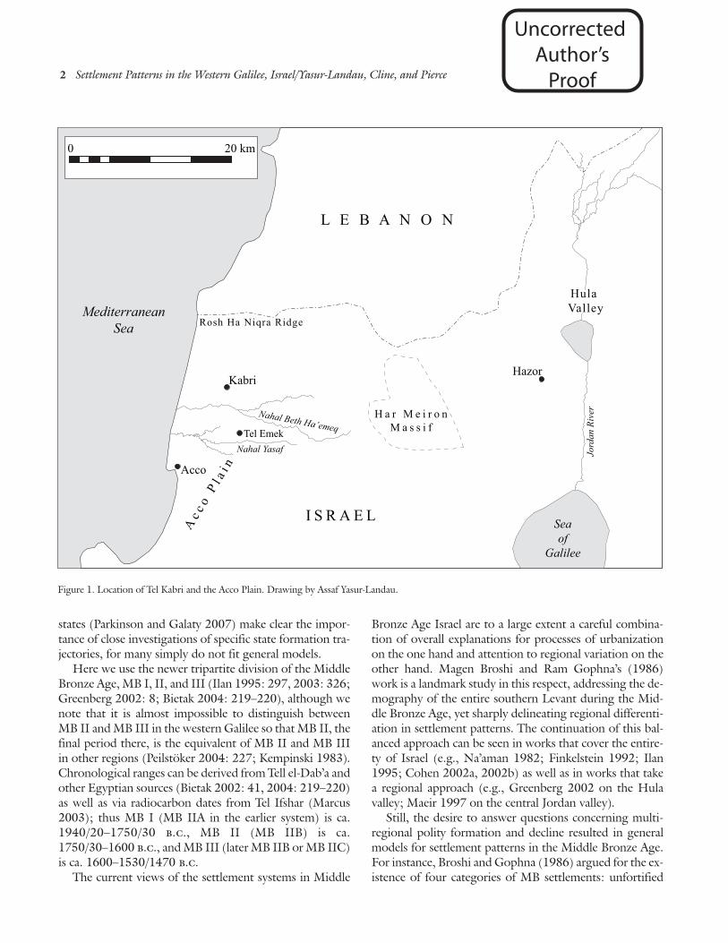
Aharon Kempinski and Wolf-Dietrich Niemeier exca-vated Tel Kabri, in the western Galilee region of Israel (fig.1), in the late 1980s and early 1990s (Kempinski,Scheftelowitz, and Oren 2002). They found that duringthe Middle Bronze Age (MB) II period (ca. 1750–1600b.c.) the site had been the center of a strong coastal polity.In size and importance, it may have been second only toHazor in the Galilee (Maeir 2000: 43; Ilan 1995: 307)and, with Ashkelon on the southern coast (Stager 2002),was arguably one of the two strongest coastal powers inMB II Canaan.
Beginning in 2005, excavations resumed at Tel Kabri aspart of a new regional study of Middle Bronze Age settle-ment patterns in the western Galilee. The Kabri Archaeo-logical Project (KAP) has so far conducted one preliminaryseason of excavation at Kabri itself (Cline and Yasur-Lan-dau 2007) and two seasons of regional studies in the terri-
tory of the polity of Kabri, which runs from the Mediter-ranean coast on the west to the foothills of the Har Meironmassif in the east and from the Rosh Ha Niqra (RekhesHa-Sulam) ridge in the north to the boundary of Acco inthe south (see below).
Our aim here is to present a picture of the polity ofKabri and its hinterland in terms of diachronic changes insettlement patterns, agricultural exploitation, and patternsof trade. The KAP conducted multiple lines of research, in-cluding excavation, intensive site survey, study of existingpottery collections, examination of available textual evi-dence, population estimates, and studies of land use andeconomy. By studying the trajectory of a specific polity, wehope to address an important gap in the exploration of theMiddle Bronze Age in the southern Levant, for there canbe a sharp dichotomy between the larger regional narrativeand the trajectory of a single polity. Recent criticism of uni-versal models of state trajectories (Yoffee 2005) and of tra-ditional nomenclature for “primary” and “secondary”
1
Middle Bronze Age Settlement Patternsin the Western Galilee, Israel
Assaf Yasur-LandauUniversity of CaliforniaSanta Cruz, California
Eric H. ClineThe George Washington UniversityWashington, D.C.
George A. PierceUniversity of CaliforniaLos Angeles, California
During the Middle Bronze (MB) II period (ca. 1750–1600 B.C.), Tel Kabri, located in thewestern Galilee, Israel, was the center of a thriving polity with economic and cultural con-nections to Egypt, Cyprus, and the Aegean. While Kabri and some neighboring sites havebeen partially excavated, the rise and fall of the polity has not been clearly understood. Wepresent evidence from the Kabri Archaeological Project (KAP) to reconstruct shifting settle-ment patterns, demography, and aspects of trade in the Kabri hinterland from MB I toLate Bronze (LB) I. We argue that Kabri, in the northern part of the Acco plain, follows adifferent developmental trajectory than does Acco and its hinterland in the southern part ofthe plain. Acco was urbanized early in MB I and developed a mature hinterland that per-sisted throughout MB II and into LB I. Kabri did not begin to bloom until late in the MBI period. Its rapid rise during MB II was accompanied by the abandonment of village sitesfar from the center of the polity and the fortification of nearby settlements. These efforts toconsolidate power and to maintain the flow of goods into the center did not last long, andthe polity of Kabri soon collapsed.
Uncorrected Author’s
Proof
2 Settlement Patterns in the Western Galilee, Israel/Yasur-Landau, Cline, and Pierce
states (Parkinson and Galaty 2007) make clear the impor-tance of close investigations of specific state formation tra-jectories, for many simply do not fit general models.
Here we use the newer tripartite division of the MiddleBronze Age, MB I, II, and III (Ilan 1995: 297, 2003: 326;Greenberg 2002: 8; Bietak 2004: 219–220), although wenote that it is almost impossible to distinguish betweenMB II and MB III in the western Galilee so that MB II, thefinal period there, is the equivalent of MB II and MB IIIin other regions (Peilstöker 2004: 227; Kempinski 1983).Chronological ranges can be derived from Tell el-Dab’a andother Egyptian sources (Bietak 2002: 41, 2004: 219–220)as well as via radiocarbon dates from Tel Ifshar (Marcus2003); thus MB I (MB IIA in the earlier system) is ca.1940/20–1750/30 b.c., MB II (MB IIB) is ca.1750/30–1600 b.c., and MB III (later MB IIB or MB IIC)is ca. 1600–1530/1470 b.c.
The current views of the settlement systems in Middle
Bronze Age Israel are to a large extent a careful combina-tion of overall explanations for processes of urbanizationon the one hand and attention to regional variation on theother hand. Magen Broshi and Ram Gophna’s (1986)work is a landmark study in this respect, addressing the de-mography of the entire southern Levant during the Mid-dle Bronze Age, yet sharply delineating regional differenti-ation in settlement patterns. The continuation of this bal-anced approach can be seen in works that cover the entire-ty of Israel (e.g., Na’aman 1982; Finkelstein 1992; Ilan1995; Cohen 2002a, 2002b) as well as in works that takea regional approach (e.g., Greenberg 2002 on the Hulavalley; Maeir 1997 on the central Jordan valley).
Still, the desire to answer questions concerning multi-regional polity formation and decline resulted in generalmodels for settlement patterns in the Middle Bronze Age.For instance, Broshi and Gophna (1986) argued for the ex-istence of four categories of MB settlements: unfortified
0 20 km
MediterraneanSea
Seaof
Galilee
HazorKabri
Tel Emek
Acco
L E B A N O N
I S R A E L
Nahal Yasaf
Nahal Beth Ha’emeq
Hula Valley
Rosh Ha Niqra Ridge
Ac c
oP
l ai n
H a r M e i r o nM a s s i f
Jord
anR
iver
Figure 1. Location of Tel Kabri and the Acco Plain. Drawing by Assaf Yasur-Landau.
Uncorrected Author’s
Proof

Journal of Field Archaeology/Vol. 33, 2008 3
rural settlements; settlements fortified with rampartswhich were built over Early Bronze Age (EB) fortified set-tlements; settlements fortified with ramparts which werefirst built in the MB period or over unfortified EB sites;and settlements fortified with walls but without ramparts.The most elaborate model of settlement patterns for theMB was presented by David Ilan (1995: 305), who con-tends that a well-structured settlement hierarchy which ex-isted in MB I became gradually more elaborate in MB II.
According to Ilan (1995), sites fell into four categoriesduring the MB I, with only the first having fortified settle-ments: regional centers and gateway communities; subre-gional centers and/or loci of specialist production or ser-vices (e.g., cult); villages; and farmsteads. During the MBII, sites fell into seven categories, with the first four havingfortified settlements ranging in size from 82 ha (Hazor) to4 ha (Beth Shean): first-order gateway communities (e.g.,Hazor); second-order gateway communities (e.g.,Ashkelon, Kabri, and Pella); third-order gateway commu-nities (e.g., Masos, Dan, Jericho, Dor, and Jaffa); regionalcenters (e.g., Megiddo, Beth Shean, Shimron, Shechem,and Gezer); subregional centers and/or loci of specialistproduction (e.g., Tell el-Hayyat, Afula, and Tel Keisan); vil-lages; and farmsteads or hamlets. In this model, Kabri isplaced second, behind only Hazor, as a second-order gate-way community. Ilan’s latter categories of rural settlementwere further elaborated upon by Arraham Faust (2005),who argued for the existence of at least two separate cate-gories of villages: independent villages, identified by therelatively high living standards of their inhabitants; and de-pendent villages, identified by poor standards of living, yetsometimes with a single outstanding structure whichhoused the landlord.
Raphael Greenberg’s (2002: 81–88) findings in theHula valley, a lowland area with prime agricultural land lo-cated in northern Israel, conformed, for the most part, toIlan’s (1995) model of settlement hierarchy and gradualdevelopment from MB I to MB II. Greenberg’s surveyfound a three to four-tiered settlement hierarchy for theMB I, headed by the centers at Tel Dan and Abil, both ofwhich had massive, well-planned fortifications. During thelater MB I, a major shift occurred in the settlement pat-terns, with the rise of the first urbanized communities. Therapid rise of Hazor to the status of a super-regional powerduring MB II (Greenberg 2002: 36, 106; Ilan 1995: 307)made it necessary to modify Ilan’s model, because of thetrajectory of this single polity (see below).
We believe that the situation at Kabri represents a “trun-cated trajectory,” characterized by a rapid rise, an atypicalsettlement hierarchy, and a rapid descent. Kabri’s suddenascent from a rural site in MB I to a dominant polity cen-
ter and a regional power by the transition to MB II is alsoreflected in the settlement pattern within its hinterland.This is a very different situation than predicted by Ilan’smodel (above), for the rise of urbanism in the northern Ac-co plain resulted in the effective elimination of most of theMB I villages and the creation of larger nucleated settle-ments, as well as a network of specialized sites connectedwith the accretion of palatial control over the area of thepolity.
While the Acco plain in general shows a gradual rise incomplexity from the MB I to MB II, the two major poli-ties of the plain—Acco in the south and Kabri in thenorth—follow very different trajectories. The site of Acco,like the plain as a whole, follows a gradual rise in complex-ity and ultimately survives into the Late Bronze (LB) I. Thesite of Kabri, on the other hand, rapidly rises and falls, allduring the MB II period.
The polity at Kabri completed a full cycle of develop-ment without any apparent external political intervention.Its position away from the major land routes from Egyptto Syria and Mesopotamia resulted in political and cultur-al isolation from the core areas of the ancient Near East. Inaddition, since access to trade items from Cyprus was nev-er limited to just the elites of the Kabri polity, overseastrade had only a marginal effect on processes of state for-mation and collapse, despite the fact that the palatial eliteof MB II Kabri used Aegean-style paintings to demonstratetheir status and possibly maintained a presence in the near-by port of Nahariya.
Historical and Archaeological BackgroundWhile the site of Kabri itself and several sites around it
(such as the tell and shrine site of Nahariya) were at leastpartially excavated before the present project, the polity asa whole was not well understood. There were no previousattempts to explore and understand the rise and fall ofKabri or its hinterland in terms of changes in settlementpatterns, agricultural exploitation, or patterns of trade.Previous surveys of this region focused on the history ofsettlement from the Neolithic to the Ottoman periods andthe 450-year-long Middle Bronze Age was treated as a sin-gle unit without a chronological separation between MB Iand MB II.
John Garstang (1922) divided the western Galilee, orAcco plain, into two sections, northern and southern,based upon geography. Kempinski (1986: fig. 1) drew apicture of the Acco plain as divided during late MB I andMB II between the kingdom of Kabri (named Rehob byhim) and the kingdom of Acco. Both kingdoms were de-picted as ruling the lowlands, with Nahal Yasaf serving as aboundary between them.
Uncorrected Author’s
Proof

4 Settlement Patterns in the Western Galilee, Israel/Yasur-Landau, Cline, and Pierce
Israel Finkelstein (1992: 210–215) used rank-sizeanalysis, weighted with literary data on the boundaries ofLB polities, to draw Thiessen polygons and establish 16territorial units in Palestine during the Middle Bronze Age.Similarly, Aaron Burke (2004: 215, 265) suggested, basedon rank-size, natural boundaries, and the presence ofplanned fortifications, that the entire Acco plain was a sin-gle kingdom with two districts, i.e., Kabri and Acco, al-though he did not hypothesize in which district lay the cap-ital of the kingdom.
Martin Peilstöker (2004: 10) focused on the Acco plainduring his investigations of the area from the Reches Ha-Sulam ridge in the north to the Carmel ridge in the south.The eastern border was the foothills of the Galilee Moun-tains. Using rank-size analysis, Peilstöker (2004: 432–433)argued for the superiority of Kabri over Acco during theMB period, based on the larger size of Kabri and its moredesirable location (having excellent water resources and anabundance of fertile land), in contrast to the sandy,swampy region of Acco. Like Kempinski and Finkelstein,he envisioned the two sites competing for supremacythroughout the Middle Bronze Age.
We agree with these scholars that there were two sepa-rate polities in the Acco plain during the Middle BronzeAge, namely Acco and Kabri. The boundary of the politycentered at Tel Kabri is geographically well-defined: to thewest lies the Mediterranean Sea; to the north Reches Ha-Sulam, which today forms the border between Israel andLebanon (fig. 1). Its imposing cliffs would be arduous tonegotiate, as confirmed by the 19th Dynasty Egyptianscribe in Papyrus Anastasi I 21,3 (Rainey and Notley2006: 102):
“Let me tell you of another difficult case—the crossing of¤ ar>umu (the ladder of Tyre). You will say “It burns morethan a sting!” So very sick is the mahar (warrior)!”
To the east are the slopes of the Har Meiron massif, thehighest mountain range in the Galilee, which also served asthe boundary of the kingdom of Hazor. While the easternboundary of the polity of Kabri may well have extended allthe way to Har Meiron, Peilstöker (2004: 437; followingFrankel et al. 2001: 103) has suggested that another poli-ty, centered at Tel Rosh, lay between Kabri and Hazor. Wehave taken this possibility into account in interpreting oursurvey data (see below). Finally, in the south, the border isassumed to lie midway between Kabri and a polity centeredat Acco, probably delineated by one of the e–w wadis. Thetwo most likely candidates are Nahal Yasaf, located ap-proximately midway between Acco and Kabri, and NahalBeth Ha’emeq, located further to the north. In order to beon the safe side, we chose Nahal Yasaf as the boundary for
our study, although Nahal Beth Ha’emeq—only 2.5 kmsouth of Tel Kabri—may have been the actual boundary.
Numerous MB sites had already been identified in theregion of Kabri prior to the beginning of our project, as aresult of previous survey work in the upper Galilee areaconducted by Rafi Frankel, Nimrod Getzov, MordechaiAviam, and Avi Dagani (Frankel and Getzov 1997; Frankelet al. 2001) and by the Israel Antiquities Authority (IAA)(see also Grootkerk 2000). Although this survey work didnot differentiate between MB I and MB II, the accuraterecording of MB sites for more than three decades createda solid foundation for the present study. In addition, re-peated visits to these sites by IAA and pre-IAA surveyteams also resulted in a massive pottery collection. Thisarchive is important, as it includes pottery from sites whichhave since disappeared as a result of development and rep-resents visits to these sites during different seasons andparts of the year over a lengthy period of time, thus ensur-ing that the collection is as complete as possible and has adeep diachronic dimension.
Recent work by Peilstöker (2004) has added additionalinformation concerning previously unpublished excava-tions of the tell of Nahariya, as well as the sites of Bira andTel Aphek (Kurdani) located in Acco territory, and hasadded a few more sites to the IAA survey as well. All of thisadditional work was limited to the lowlands of the Accoplain, however (Peilstöker 2004: 424–425); it did not in-clude any surveying of the higher hills of the region.
Moreover, these earlier surveys concentrated only onidentifying archaeological remains such as sherds, flints,and architecture. While they provided valuable informa-tion on the number of sites inhabited through all periodsin the upper Galilee (including the MB period), they didnot record attributes of the terrain, available arable land,lines of vision, or water and other resources.
MethodsArchaeological surveys in the Levant tend to follow a
standard methodology that includes systematic fieldwalk-ing, collection of pottery and other artifacts, documenta-tion of architectural features, and standardized publication,frequently as part of the Archaeological Survey of Israel se-ries (e.g., Olami 1984; Broshi and Gophna 1984, 1986;Levy and Alon 1987; MacDonald 1988; Zertal 1992; Ban-ning 1996; Finkelstein, Lederman, and Bunimovitz 1997;Cohen 2002a, 2002b). More recent surveys conductedoutside of Israel, such as those in the Pylos region (Daviset al. 1997; Zarinebaf, Bennet, and Davis 2005), the Ik-laina region (Cosmopoulos 2006), the Korinthia region(Caraher, Nakassis, and Pettegrew 2006), the island ofKythera in Greece (Broodbank and Kiriatzi 2007), Cyprus
Uncorrected Author’s
Proof

Journal of Field Archaeology/Vol. 33, 2008 5
(Given and Knapp 2003; Kardulias and Yerkes 2004), andMesopotamia (Wilkinson et al. 2005), have combined ce-ramic analysis, satellite and aerial imagery, textual refer-ences, and computer applications such as GIS with tradi-tional fieldwalking and site descriptions.
We have endeavored, in the same manner as the surveysin Greece, Cyprus, and Mesopotamia, to bring historicaland archaeological data to bear on our questions about TelKabri and its environs during the Middle Bronze Age.Since so much pottery was collected from the MB sites dur-ing previous surveys and over an extended period of time,we decided that additional pottery collection would have amarginal impact on our results. We therefore devised astrategy to maximize the results of our project, especiallygiven the limited time and staff available.
First, we decided to examine the MB sites already iden-tified by the previous surveys in the western Galilee, ratherthan to attempt to resurvey the entire region again on foot.Our decision was, in part, influenced by the observationthat when Peilstöker and Lehmann (Peilstöker 2004:229–373) meticulously resurveyed the area east of Acco,
they added only three new sites to the roster of MB settle-ments in the western Galilee, none larger than 0.2 ha. Inour opinion, the recurring visits of the IAA teams to manyof the sites, and in different seasons, have effectively coun-tered low surface visibility during the summer in Israel—the time when many archaeological activities are usuallyconducted. While we visited sites in an attempt to establishtheir size according to the extent of the MB pottery scat-ters, we also utilized the pottery collected by previous sur-veys to determine the chronology of each MB site.
Although the above surveys in Greece, Cyprus, andMesopotamia, plus those conducted in Israel by theMegiddo Expedition (Finkelstein et al. 2006) of theBronze and Iron Age sites in the Jezreel Valley and by Yu-val Gadot (1999: 60) of the Bronze and Iron Age sites inthe Wadi ‘Ara, have demonstrated that survey parties of10–15 people are the ideal size for efficiently surveying apreviously-identified site, our team was smaller, usuallyconsisting of five people (the authors plus two other teammembers). Our survey method was the standard one prac-ticed in all of these regions (e.g., Davis et al. 1997:400–401). Team members were spaced 10–15 m apartwhile walking transects and documented (but did not col-lect) pottery, flint, and other artifacts and recorded placesof special interest (e.g., walls). The length of the transectswas determined by the topography of each site, in order toachieve maximum coverage: at flat alluvial sites such asKhirbet Umm Tuma, transects were as long as 200 m,while at hilly terraced sites such as ‘Avdon, the transectswere determined by the length of the terraces. After an ini-tial walk of the site, the team established the boundaries ofthe MB pottery scatters that were then recorded with GPSreadings.
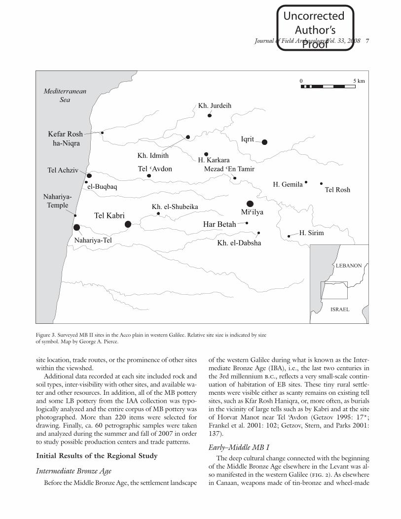
The KAP team visited nearly all of the sites (more than90%) previously identified as MB in the region (figs. 2, 3)during the summers of 2006 and 2007. We were able tocorrect many of the previous estimates for the sizes of MBsites in the western Galilee and to generate an improved es-timate of past population sizes in this region (table 1).Thus, for example, the hilltop site of Mi’ilya, previously es-timated to be only 1.5 ha in size, turned out to actually be23.75 ha, making it a new major MB and LB site in thewestern Galilee. On the other hand the border fortress ofMezad ‘En Tamir, previously estimated to be 0.3 ha in size(Frankel et al. 2001: 28), is apparently composed of only asingle sturdy structure 0.056 ha in area.
Site boundaries were recorded using a WAAS-enabledGPS device, with 1–3 m accuracy. These GPS points werelater downloaded to a GIS with topographic maps and thepotential outline of each MB site was digitized as a poly-gon, allowing us to determine the area occupied (which in
IAA survey KAP surveySite name size (ha) size (ha) Period
el-Buqbaq 1.0 0.28 MB I, MB IIel-Mansura 1.2 0.93 MB IElon 2 0.2 0.3 MB IHar Betah (south) 0.8 – MB II
Har Hanita 2 0.1 – MB IHorvat Fazelet 5.0 13.47 MB IHorvat Gemila 1.5 0.31 MB IIHorvat Hur 2.0 – MB I
Horvat Karkara 1.9 1.09 MB I, MB IIHorvat Sirim 0.6 0.13 MB IIIqrit 2.5 9.57 MB IIJatt 3.0 – MB I
Kefar Rosh ha-Niqra 1.0 – MB II?Khirbet el-Dabsha 1.0 0.28 MB I-MB IIKhirbet el-Shubeika 0.3 – MB IIKhirbet Idmith 1.6 1.94 MB II?
Khirbet Jurdeih 1.0 2.64 MB I, IIKhirbet Umm Tuma 2.0 1.43 MB IMe’arat Namer 0.1 – MB IMezad ‘En Tamir 0.3 .056 Late MB I
or early MB II
Mi’ilya 1.5 23.75 MB IINahariya-Tel 4.0 – MB I, MB IINahariya-Temple 0.1 0.1 MB I, MB IITel Achziv 7.0 5.47 MB I, MB II
Tel ‘Avdon 2.0 2.85 MB IITel Kabri 30.0 15–20 in MB I; MB I, MB II
32 in MB IITell el-Sumeiriya 4.5 1.12 MB ITel Rosh 9.0 0.76 MB I, MB II
Table 1: Preliminary size and chronology of surveyedMB I–II sites.
Uncorrected Author’s
Proof

6 Settlement Patterns in the Western Galilee, Israel/Yasur-Landau, Cline, and Pierce
some cases differed from the original surveyors’ estimate).Historical maps, tax records, and satellite imagery from the1960s, 1990s, and the present day were also consultedwhen drawing the site boundary polygons and have provedinvaluable when MB sites are no longer visible.
In fact, there has been rapid development in the entirearea, with the result that some MB sites reported by previ-ous surveys, such as those at Kfar Rosh Haniqra and TelNahariya, are now completely invisible and/or inaccessible.Others have apparently disappeared completely, perhaps asa result of building activities in the area. In addition, ourvisits to some sites previously reported as having MB pot-tery or structures, such as Horvat Gayis (Frankel et al.2001: 32, no. 239), yielded no such MB pottery or struc-tures. In these cases, the pottery collected by the previoussurveys was examined, and if no MB pottery was found,
the sites were erased from the IAA register of MB sites.At each of the sites visited during the survey, pho-
tographs were taken for visibility studies. Such studies havebeen performed elsewhere on landscapes in order to deter-mine the prominence of a site in its natural and social set-tings (e.g., Gaffney, Stancic, and Watson 1996; Lock andHarris 1996; Wheatley and Gillings 2000). Our photogra-pher climbed to the highest spot on the site and took a se-ries of photographs in a complete circle. These pictureswere later “stitched” together using computer software anda small movie was produced that allows the user to zoomin and pan around the landscape from the vantage point ofthe photographer (fig. 4). This resulting viewshed may beuseful in attempting to reconstruct the situation during theMiddle Bronze Age for the site’s inhabitants (Wheatley andGillings 2002: 201–202) and may provide insights about
LEBANON
ISRAEL
0 5 km
Mezad En Tamir
Tel Kabri
Kh. Jurdeih
H. Karkara
Kh. el-Dabsha
Tel Rosh
H. FazeletTel Achziv
el-BuqbaqNahariya-
Temple
Nahariya-Tel
el-Mansura
Jatt
Tell el-Sumeiriya
Elon 2
MediterraneanSea
Har Hanita 2
Kh. Umm Tuma
H. Hur Mearat Namer
Figure 2. Surveyed MB I sites in the western Galilee, with hectares in parentheses. Relative site size isindicated by size of symbol. Map by George A. Pierce.
Uncorrected Author’s
Proof
Journal of Field Archaeology/Vol. 33, 2008 7
site location, trade routes, or the prominence of other siteswithin the viewshed.
Additional data recorded at each site included rock andsoil types, inter-visibility with other sites, and available wa-ter and other resources. In addition, all of the MB potteryand some LB pottery from the IAA collection was typo-logically analyzed and the entire corpus of MB pottery wasphotographed. More than 220 items were selected fordrawing. Finally, ca. 60 petrographic samples were takenand analyzed during the summer and fall of 2007 in orderto study possible production centers and trade patterns.
Initial Results of the Regional Study
Intermediate Bronze Age
Before the Middle Bronze Age, the settlement landscape
of the western Galilee during what is known as the Inter-mediate Bronze Age (IBA), i.e., the last two centuries inthe 3rd millennium b.c., reflects a very small-scale contin-uation of habitation of EB sites. These tiny rural settle-ments were visible either as scanty remains on existing tellsites, such as Kfar Rosh Haniqra, or, more often, as burialsin the vicinity of large tells such as by Kabri and at the siteof Horvat Manot near Tel ‘Avdon (Getzov 1995: 17*;Frankel et al. 2001: 102; Getzov, Stern, and Parks 2001:137).
Early–Middle MB IThe deep cultural change connected with the beginning
of the Middle Bronze Age elsewhere in the Levant was al-so manifested in the western Galilee (fig. 2). As elsewherein Canaan, weapons made of tin-bronze and wheel-made
LEBANON
ISRAEL
0 5 km
Mezad En Tamir
Tel Kabri
Kh. Jurdeih
H. Karkara
Tel Rosh
Tel Achziv
el-BuqbaqNahariya-
Temple
Nahariya-Tel
MediterraneanSea
Kh. el-Shubeika
Kh. Idmith
Tel Avdon
Iqrit
Miilya
Kh. el-Dabsha
H. Gemila
Har Betah
Kefar Rosh ha-Niqra
H. Sirim
Figure 3. Surveyed MB II sites in the Acco plain in western Galilee. Relative site size is indicated by sizeof symbol. Map by George A. Pierce.
Uncorrected Author’s
Proof

8 Settlement Patterns in the Western Galilee, Israel/Yasur-Landau, Cline, and Pierce
pottery with typological connections to northern Levan-tine traditions in Syria and Lebanon made their first ap-pearance (Ilan 1995: 30–301; Greenberg 2002:105–106). Both of these cultural innovations are present inTomb 990 at Kabri, a warrior tomb which is possibly theearliest MB I tomb in the western Galilee and which yield-ed both wheel-made pottery (Scheftelowitz 2002: 30;Scheftelowitz, Kempinski, and Gershuny 2002: fig. 5.58,profiles 1–5) and a bronze duck-bill axe (Shalev 2002:309).
The earliest phase (Phase 1) of MB I (Cohen 2002a: fig.9) is completely missing from the area studied by the KAP.Instead, intensive settlement both on tells and in rural sites,as well as the founding of new cemeteries, is evident start-ing in the intermediate phases (Phases 2–3) of the MB I(e.g., Cohen 2002a: fig. 11; Kochavi and Yadin 2002).This phenomenon is well-represented in excavation datafrom the region, e.g., tombs at Jatt (Getzov and Nagar2002), Tomb 990 at Kabri (above), and in domestic re-mains from Stratum 4 at Kabri (Scheftelowitz, Kempinski,and Gershuny 2002: 120). The analysis of survey potteryshows a similar picture, especially at sites such as HorvatHur and Khirbet Umm Tuma (fig. 5) which were appar-ently founded during this phase. These sites have potterytypes similar to those in Aphek Phases 2 and 3, MegiddoStrata XIV and XIIIa, and Qiriat Shmona Stratum VII(figs. 6, 7).
The settlement landscape of MB I in the western Galileeincluded mostly villages (or hamlets), such as Elon 2, Hor-vat Hur, Har Hanita 2, el-Mansura, Jatt and Khirbet UmmTuma, whose sizes are variable but do not exceed 1 ha(table 1). It is very likely that many more such villages ex-
isted but have since been covered by alluvium or hiddenbeneath later settlements. The availability of arable landand water resources, rather than security, appears to havebeen the reason for the location of these small sites, whichare scattered evenly over the area. Many of them are not lo-cated on top of natural hills or on other easily defended po-sitions. Khirbet Umm Tuma is an example of such a settle-ment (fig. 5), located at the foot of an imposing hill on thenorthern edge of the Biq’at Shefa’ Valley, a large area ofprime agricultural land. The site has been heavily plowedin recent years, bringing to the surface large amounts ofpottery and other materials, such as loom weights and MBsickle blades.
The lack of an urban polity in the northern part of thewestern Galilee during MB I, and the distance between thevillages, located far from the emergent MB I polity of Ac-co (see below), suggests that these settlements enjoyed anindependent status. Support for this hypothesis comesfrom the discovery of Cypriot White Painted pottery atKhirbet Umm Tuma and in the Jatt tombs (Getzov andNagar 2002) which indicates that these villages had accessto luxury imported pottery, without the interference of anycentral political control (Faust 2005).
Settlements at sites such as Tell el-Sumeiriya, Tel Achziv,and Tel Kabri (Kempinski, Scheftelowitz, and Oren 2002:451) may have been even larger in size in MB I Phases 2–3,yet were unfortified and do not display any other traits,such as monumental architecture, that would indicate cen-tral power. The only non-residential site of the period wasthe small coastal cultic center at Nahariya, where excava-tions have uncovered evidence for continuous activity fromthe IBA to MB I (Ben-Dor 1950, 1951; Dothan 1956a,
Figure 4. Photo mosaic of Khirbet el-Dabsha from the south. Photographs by George A. Pierce and AssafYasur-Landau.
Uncorrected Author’s
Proof

Journal of Field Archaeology/Vol. 33, 2008 9
1956b, 1993). This unique continuity may be used to sup-port the suggested independent status of the site in MB I.
The rural picture in the northern part of the Acco plainis in direct contrast with the situation in the southern partof the plain, which was dominated in MB I by Acco—theonly fortified center in the western Galilee and which hasMB I Phase 2 pottery deposited in a context postdating thebuilding of the rampart (Raban 1991: fig. 9).
Additional supporting evidence for a differentiation insettlement patterns between the southern and northernparts of the western Galilee at this time comes from thecontemporary Egyptian Execration Texts. The earlier Sethe(1926) or Berlin Group is commonly dated to the early12th Dynasty and the late 20th century b.c., while the lat-er Posener (1940) or Brussels Group is commonly dated tothe late 12th Dynasty and the 19th century b.c. (but cf.Redford 1992: 87, who dates them to the 19th and 18thcenturies respectively). Enumerating the enemy sites ofearly Middle Kingdom Egypt, on clay bowls for the earli-er group and on figurines of captives in the later group,these texts provide tantalizing clues to the settlement pat-terns of early Middle Bronze Age Canaan, including theAcco plain. The toponym >-k-ya of the Posener Group (E49) is very likely a reference to Acco, with a single ruler,$al->Ammu. Four further toponyms, nos. E11–14 in thelater (Posener) Group, are widely accepted as also origi-nating from localities within the Acco plain: <á-k-sap-a(E11), <á-∞-<á-pa (E 12), ma-¡-a-l-a (E 13), and <a-r-˙-b-u-m (E 14).
The toponym <á-k-sap-a (E11) is generally thought tohave been vocalized as <Ak®apa, while ma-¡-a-l-a (E 13) isseen as Ma¡<la/Mishal. These appear side by side in both
the Posener Group (Helck 1971: 53; Rainey and Notley2006: 58) and in the Topographical List of Thutmose III(no. 39 ma-¡a-<a-la, no. 40 <a-k-sap; Rainey and Notley2006: 72). Undoubtedly, <á-k-sap-a of the Execration Textsis the same as <A-k-∞a-pu in the Papyrus Anastasi I from thedays of Ramses II. The latter, usually transliterated andidentified as Achshaph, is listed in the Papyrus Anastasi asbetween Acco and Mount User (probably Mount Carmel),thus locating it within the Acco plain. Petrographic analy-sis of the 14th century b.c. el-Amarna Letter 223 (Goren,Finkelstein, and Na’aman 2004: 231–233) sent by En-daruta of Achshaph to the king of Egypt has shown thatthe origin of the tablet is likely to be Tell Keisan in thesouthern Acco plain, thus significantly favouring TellKeisan as the location of ancient Achshaph, a suggestionwhich was first made half a century ago by Yohanan Aha-roni (1957: 121). If this is correct, then Ma¡<la/Mishal isbest identified with Tell el-Na˙l, located ne of the modernrefinery on Haifa Bay (Mazar 1974: 27; A˙ituv 1984:143).
The toponym <a-r-˙-b-u-m (E 14), vocalized as<Ar˙abum/Rehob, was identified by Shmuel A˙ituv (1984:163–164) as Tell Birwe or Tel Bira in the Acco plain, an im-portant site during MB II (Peilstöker 2004: 63). Howev-er, Kempinski (1986; Kempinski, Scheftelowitz, and Oren2002: 452) suggested Tel Kabri in the western Galilee asthe location of Middle and Late Bronze Age Rehob, bear-ing in mind the importance of both Kabri and <a-r-˙-b-u-m in late MB I. Finally, <á-∞<-á-pa (E 12), vocalized as<A∞<apa, is very likely to be the same as ya-∞-a-pa (e 31, f 21)of the earlier group of Execration Texts (Helck 1971: 49,53; A˙ituv 1984: 201). The name <á-∞<-á-pa may be pre-
Uncorrected Author’s
Proof

10 Settlement Patterns in the Western Galilee, Israel/Yasur-Landau, Cline, and Pierce
served to this day in Kfar Yasif, yet there are no MB remainsin the immediate vicinity of the village, and indeed nonehave been found within a 4–5 km radius from the center ofthe village, despite the extensive survey and salvage excava-tions conducted in the vicinity (Frankel et al. 2001: 14, site43). The fact that only Hellenistic and later remains werefound may indicate that the name of the site “wandered”through the ages.
Despite the difficulties in identification, it seems thatmost of the sites mentioned in the Egyptian ExecrationTexts were located to the south and east of Acco, i.e. with-in the borders of the Acco polity. The lack of toponymsfrom the northern Acco plain, with the possible exceptionof Kabri, corresponds well with the lack of evidence forcomplexity in the area through most of the MB I period.
Late MB I and Transitional MB I–II During late MB I and the transition to MB II, a sharp
change in settlement patterns is evident, manifested by theappearance of a large fortified center at Kabri and sec-ondary fortified centers at Tel Achziv, Tel ‘Avdon, andMezad ‘En Tamir (fig. 3). These indicate the swift rise of apolity centered at Kabri. The ramparts of Kabri, built dur-ing the late MB I, encircle an area of 32 ha, two or moretimes larger than the size of the earlier MB I settlement(Kempinski, Scheftelowitz, and Oren 2002: 451). At thesame time, a very large late MB I public structure or “pro-to-palace” was built at the site. Belonging to Stratum 4,
this structure preceded the better-known palace of Kabri inStratum 3 (see below).
The fortifications at the smaller site of Tel Achziv, whichinclude a rampart encircling an area of ca. 5.5 ha (Oren1975; Prausnitz 1975), indicate its role as a center sec-ondary to Kabri. The fortifications may be slightly laterthan those at Kabri, having been built during transitionalMB I–II, according to the pottery found in the core of theAchziv rampart. It is important to note that the core doesnot contain clear MB I ceramic forms of the Acco plain,such as the gutter-rim cooking pots which were found in adeposit sealing the rampart at Acco (Raban 1991: fig. 9) orthe closed, carinated, red-slipped bowl found within therampart at Kabri (Scheftelowitz, Kempinski, and Gershuny2002: fig. 5.63:3). It does contain later, open, carinatedbowls (Oren 1975: type 27), which are transitional MBI–II and MB II types, and jars with ribbed rims (Oren1975: type 61), which are late MB I or transitional MBI–II types.
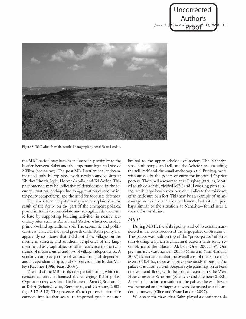
The steep slopes of Tel ‘Avdon, in contrast to the ter-raced shape so typical of unfortified sites (fig. 8), stronglysuggests the presence of Middle Bronze Age fortifications.The survey pottery from the site, including sherds that maybe either transitional MB I–II or early MB II types, indi-cates that it was probably fortified at around the same timeas Achziv.
A fort site, Mezad ‘En Tamir, was built above the ravineof Nahal Kheziv with a fine view towards the west (Getzov
Figure 5. Khirbet Umm Tuma from the south. Photograph by Assaf Yasur-Landau.
Uncorrected Author’s
Proof

Journal of Field Archaeology/Vol. 33, 2008 11
0 10 cm
Figure 6. Pottery from Khirbet Umm Tuma. Drawings by Natalie Mesika.
Uncorrected Author’s
Proof

12 Settlement Patterns in the Western Galilee, Israel/Yasur-Landau, Cline, and Pierce
1991, 2000). It has only one structure, built of masonry,consisting of a series of rooms encircling a large centralcourt. Pottery found within the debris dates to late MB Ior early MB II and indicates a short life span. Its well-planned monumental architecture and its location, withoutany arable agricultural land in its vicinity, attest to its spe-cialized role as either an eastern border fort of the Kabripolity, or, as suggested by Rafi Frankel and his colleagues(2001: 103) and Peilstöker (2004: 734), a western borderfort of a polity centered at Tel Rosh.
An important trait of the transition between MB I andMB II is the depletion of the countryside. Almost all thesmall MB I village sites, such as Jatt, Horvat Hur, KhirbetUmm Tuma, el-Mansura and Har Hanita 2, did not con-tinue into MB II. One example of a major lowland villagethat was deserted after MB I is Tell el-Sumeiriya. Locatedbetween Acco and Kabri, its desertion may have been dueto a conflict between these two rising polities early in theMB II period, the time during which the large palace atKabri was built. Similarly, the abandonment of Jatt after
0 10 cm
0 5 cm
Figure 7. Pottery from Khirbet Umm Tuma. Drawings by Natalie Mesika.
Uncorrected Author’s
Proof
Journal of Field Archaeology/Vol. 33, 2008 13
the MB I period may have been due to its proximity to theborder between Kabri and the important highland site ofMi’ilya (see below). The post-MB I settlement landscapeincluded only hilltop sites, with newly-founded sites atKhirbet Idmith, Iqrit, Horvat Gemila, and Tel ‘Avdon. Thisphenomenon may be indicative of deterioration in the se-curity situation, perhaps due to aggravation caused by in-ter-polity competition, and the need for adequate defenses.
The new settlement pattern may also be explained as theresult of the desire on the part of the emergent politicalpower in Kabri to consolidate and strengthen its econom-ic base by supporting building activities in nearby sec-ondary sites such as Achziv and ‘Avdon which controlledprime lowland agricultural soil. The economic and politi-cal stress related to the rapid growth of the Kabri polity wasapparently so intense that it did not allow villages on thenorthern, eastern, and southern peripheries of the king-dom to adjust, capitulate, or offer resistance to the twintrends of urban control and loss of village independence. Asimilarly complex picture of various forms of dependentand independent villages is also observed in the Jordan Val-ley (Falconer 1995; Faust 2005).
The end of the MB I is also the period during which in-ternational trade influenced the emerging Kabri polity.Cypriot pottery was found in Domestic Area C, Stratum 4,at Kabri (Scheftelowitz, Kempinski, and Gershuny 2002:figs. 5.17, 5.18). The presence of such pottery in non-elitecontexts implies that access to imported goods was not
limited to the upper echelons of society. The Nahariyasites, both temple and tell, and the Achziv sites, includingthe tell itself and the small anchorage at el-Buqbaq, werewithout doubt the points of entry for imported Cypriotpottery. The small anchorage at el-Buqbaq (fig. 9), locat-ed south of Achziv, yielded MB I and II cooking pots (fig.10), while large beach-rock boulders indicate the existenceof an enclosure or a fort. This may be an example of an an-chorage not connected to a settlement, but rather—per-haps similar to the situation at Nahariya—found near acoastal fort or shrine.
MB IIDuring MB II, the Kabri polity reached its zenith, man-
ifested in the construction of the large palace of Stratum 3.This palace was built on top of the “proto-palace” of Stra-tum 4 using a Syrian architectural pattern with some re-semblance to the palace at Alalakh (Oren 2002: 69). Ourpreliminary excavations in 2005 (Cline and Yasur-Landau2007) demonstrated that the overall area of the palace is inexcess of 0.4 ha, twice as large as previously thought. Thepalace was adorned with Aegean-style paintings on at leastone wall and floor, with the former resembling the WestHouse fresco at Santorini (Niemeier and Niemeier 2002).As part of a major renovation to the palace, the wall frescowas removed and its fragments were deposited as a fill un-der a doorway (Cline and Yasur-Landau 2007).
We accept the views that Kabri played a dominant role
Figure 8. Tel ‘Avdon from the south. Photograph by Assaf Yasur-Landau.
Uncorrected Author’s
Proof

14 Settlement Patterns in the Western Galilee, Israel/Yasur-Landau, Cline, and Pierce
on the Acco plain during the MB II period (Ilan 1995:307; Maeir 2000: 43; Peilstöker 2004: 432–433). At thesame time, Acco—although perhaps subordinate toKabri—maintained its MBI settlement hierarchy and thusremained an important regional center (Kempinski,Scheftelowitz, and Oren 2002: 451; Finkelstein 1992;Burke 2004: 215, 265).
The MB II Kabri polity is distinguished by a varied set-tlement landscape (fig. 3) with several specialized settle-ments, perhaps reflecting the interests of the elite. Suchspecialized settlements include the coastal Nahariya tem-ple. This had been founded in the MB I period as a hum-ble cult site, originally consisting of an open air-shrine andbamah (a high place for cultic use), but reached its periodof greatest prosperity during the MB II period, at whichtime it was enlarged and reconfigured as a rectangularshrine and large platform—perhaps an altar—that coveredthe earlier MB I remains (Dothan 1993: 1090). Overlook-ing the temple is the rather small fort that may have beenused to protect the trading interests of the polity. In addi-tion, the anchorage of el-Buqbaq continued to be usedthroughout this period.
Side by side with the floruit of Kabri during the MB IIperiod, we note another concentration of sites in the high-lands east of Kabri, on the eastern and ne slopes of HarMeiron. The largest settlement was the ca. 24 ha site ofMi’ilya, a large tell which would ultimately outlast Kabri(fig. 3). Another important site was Horvat Fazelet, where
rich tombs were found, including one that yielded a scarabof Nefer-Hotep I of the 13th dynasty (Aviam 1989/1990:92). Smaller sites in the area such as Tel Rosh, HorvatGemila, Har Betah, and perhaps Khirbet el-Dabsha, aremostly on hilltops. A typical rural site founded in this peri-od is Horvat Sirim, located on the top and slopes of a lowhill (figs. 11, 12).
This settlement cluster with apparent internal hierarchymay support the suggestion by Frankel and his colleagues(2001: 103) that another polity existed between Kabri andHazor. The diminutive size of Tel Rosh during MB II doesnot allow us to reconstruct it as the regional center of thiseastern polity (contra Peilstöker 2004: 437); instead, wewould suggest Mi’ilya.
The destruction of Kabri and its palace at the end of MBII came at the same time as the end of some of the othersettlements in the western Galilee. Yet habitation contin-ued at several of the secondary sites, such as ‘Avdon and TelRosh, and there was a continuity of activity in both thetemple and fort of Nahariya through LB I. The demise ofKabri was accompanied by the foundation of a new settle-ment at Tel Emek (fig. 1), located only 2 km se of Kabri,which utilized some of the agricultural lands previously be-longing to Kabri.
The regional vacuum was filled in part by an increase inthe political power of Acco and a continuation in the habi-tation of the major hilltop center of Mi’ilya. Mi’ilya was ac-tive through LB I, as evident by Cypriot Bichrome and
Figure 9. Anchorage at el-Buqbaq from the east. Photograph by Assaf Yasur-Landau.
Uncorrected Author’s
Proof

Journal of Field Archaeology/Vol. 33, 2008 15
Base Ring I ware found during the KAP survey (fig. 13).The presence of these imported wares indicates a continu-ation in trade and international contacts in the area even af-ter the fall of Kabri and its networks.
Land Use, Economy, and PopulationA careful integration of floral and faunal remains from
excavations, GIS analysis of the survey are, and environ-mental data allows us to make several suggestions about
the economy and population of the western Galilee duringthe MB. While the underlying geology of the coastal plainis mainly sand dunes, loam, and alluvium of the Kukargroup, the hills in the eastern portion of our survey area arecomposed of Cenomanian chert and dolomite, Turonianlimestone, and Senonian and Eocene chalk (Sneh 2004).Soils include terra rossa, brown and pale rendzinas, clay-laden vertisols (grumusols), alluvial deposits, and hamrasoils (Survey of Israel 1985).
0 10 cm
0 5 cm
Figure 10. Pottery from el-Buqbaq. Drawings by Natalie Mesika.
Uncorrected Author’s
Proof

16 Settlement Patterns in the Western Galilee, Israel/Yasur-Landau, Cline, and Pierce
Water sources in the area are limited to springs, wells,and the seasonal wadis that flow through western Galilee.Rainfall averages between 500 and 700 mm per year (Sur-vey of Israel 1985; Frankel et al. 2001: 2). Several springswould have served the settlements and their pastoral com-ponents. For example, Kabri is built around two springs,‘Ein Giah and ‘Ein Shefa (Horowitz 2002: 9), whichwould have provided ample water even during droughts(Tsuk 2002). Man-made wells and cisterns provided waterto sites such as Horvat Fazelet and Jatt (Nimrod Getzovpersonal communication, 2006). In addition to springsand wells, several seasonal streams such as Nahal Bezet,Nahal Kheziv, Nahal Sha‘al, Nahal Ga’aton, Nahal BethHa ‘Emeq, and Nahal Yasaf, as well as several additionalfeeder streams, run through the survey area and wouldhave been a source of water during wetter months.
The analysis of botanical and faunal remains recoveredduring the excavations at Tel Kabri sheds light on the foodsources and the agro-pastoral economy of the westernGalilee during the MB. Carbonized olive stones indicatethat olives formed part of the inhabitants’ diet (Liphschitz2002: 403). Faunal analysis reveals a varied exploitation ofdomesticated caprovines and bovines, as well as a few wildspecies such as gazelle, fallow deer, and possibly wild boar(Horowitz and Mienis 2002: 398).
Sheep and goats were used primarily for secondaryproducts, while cattle were employed for traction andtransport with meat and milk being of secondary impor-
tance (Horowitz and Mienis 2002: 400). It is also likelythat male animals 2–3 years old were culled for meat andthat some of these may have been funerary offerings in theMB burials similar to those recovered at Hazor (Horowitz1997: 346; Horowitz and Mienis 2002: 397–398).
Freshwater crabs, edible mollusks, and saltwater fishadded variety to the diet of MB Kabri (Horowitz and Mie-nis 2002; Lernau 2002). Remains of Nile perch indicatetrade with Egypt, although the fish may have been indige-nous to Levantine coastal rivers (Lernau 2002: 425).While this marine component of the Kabri diet was prob-ably not as common at other inland sites within the surveyarea, the possibility exists that MB peoples exploited everyopportunity to acquire food. In addition, AharonHorowitz (2002: 11) mentions the presence of fig treesand raspberry bushes near stream beds, both of which mayhave present during the MB period, but which are not rep-resented in the archaeological finds from Tel Kabri.
If the climate of the western Galilee was more humidduring the MB period than it is today, as the cores fromHaifa Bay suggest (Horowitz 2002: 13), it is likely thatagriculture flourished and pastoralists grazed livestock inmarshy areas around the springs of western Galilee. Sheepwere preferred over goats, as suggested by faunal remainsat Sasa and Hazor (Horowitz 1997: 346).
Finally, regarding the estimation of past populations,there are several suggested methods employing archaeo-logical data such as site areas, numbers, and sizes of
Figure 11. Horvat Sirim from the south. Photograph by Assaf Yasur-Landau.
Uncorrected Author’s
Proof

Journal of Field Archaeology/Vol. 33, 2008 17
dwellings, artifacts such as cooking pots, food remains, andmortuary data (Hassan 1981: 66–83). Inscriptions andtextual references have also been used, although critics ofancient authors’ population figures have shown that theyare not always trustworthy (Duncan-Jones 1963; Broshi1979: 6). One widely used method is the calculation of thenumber of inhabitants according to dwelling floor space(Narroll 1962; Schacht 1981: 125) or of family size perdwelling in conjunction with all architectural characteris-tics (Sanders 1965: 133–137; Braidwood and Reed 1957;Charlton 1972; Shiloh 1980; Zorn 1994; but see Schloen2001 for critiques of Shiloh 1980 and Zorn 1994). Mostof these methods for estimating past population sizes,however, require extensive archaeological excavation andthe uncovering of architectural features and are thereforeinapplicable for the analysis of survey data.
One of the more basic and widely applied methods ofestimating past population using survey data involves mul-tiplying the size of a site by a coefficient (usually related topersons per ha or sq km and based on ethnographic analo-gy). This method has been employed in previous estimatesof the population of Palestine during the EB II–III, MB II,Iron Age II, and Byzantine periods (Broshi 1979; Broshiand Gophna 1984; Broshi and Gophna 1986; Broshi andFinkelstein 1992) as well as for 3rd millennium Sumer(Braidwood and Reed 1957) and for larger portions of theEastern Mediterranean (Angel 1972). While this method isacknowledged as being well-suited for regional studies(Broshi and Finkelstein 1992; Zorn 1994), it is nonethe-less hindered by factors such as the proportion of public toresidential buildings (Redman and Anzalone 1980; vanBeek 1982) as well as settlement type, cultural complexity,ethnic spacing standards, and environmental circumstances(Mayerson 1967: 40; Schacht 1981: 128).
Broshi and Gophna (1986: 74) consider a density coef-ficient of 250 persons per ha to be sufficiently accurate forMB sites; in fact, the number is perhaps a bit low forMB/LB urban communities. If we take this suggested den-sity coefficient of 250 persons per ha and multiply it by thenumber of settled hectares within our survey area, we getan approximate total of 28,000–29,000 people living with-in the region of the kingdom of Kabri in the westernGalilee during both the MB I and MB II periods. Wereached these numbers by following the methodology ofBroshi and Gophna (1986: 74): adding up the settledhectares from each site in each period; subtracting half ofthe area at the three fortified sites (Kabri, Achziv, and ‘Av-don) in order to account for the area taken up by the for-tifications, which results in a total of 112.93–117.93 set-tled ha in MB I and 118.85 settled ha in MB II; and thenmultiplying the result by 250 people per settled hectare.
This population estimate is also significant for the estab-lishment of Kabri as an administrative center. MB II Kabri,with its 32 ha and 4,000–6,500 inhabitants, represents anagglomeration of population on a scale which, accordingto Steven Falconer (1995) and William Dever (1993:100), would have been dependent on the hinterland for itsfood supply.
Broshi and Gophna (1986: 87) suggest a total popula-tion for Canaan of 140,000 people during the MB I and atotal population of 150,000 during the MB II. If so, theestimated population of the western Galilee would haverepresented approximately 20% of the total. However,their estimate of overall population is probably too low,since they did not include many of the sites that were latermentioned in the survey of the Upper Galilee by Frankeland Getzov (1997; see also Frankel et al. 2001).
The scale of the estimated population for the polity ofMB Kabri seems to be in accord with Ottoman populationrecords from the countryside of the Ottoman district ofAcco (Qazå of ‘Akkå). The area of this district may be com-
10 cm0
Figure 12. Pottery from Horvat Sirim. Drawings by Natalie Mesika.
Uncorrected Author’s
Proof

18 Settlement Patterns in the Western Galilee, Israel/Yasur-Landau, Cline, and Pierce
parable to the territory of Kabri (Frankel et al. 2001: 122),since it included the entire Acco plain up to Rekhes Ha-Su-lam. Although it extended more to the south than did theterritory of Kabri, it did not include the foothills and theareas around Mi’ilya which are part of the MB populationestimate. The district itself had a pre-industrial Mediter-ranean subsistence economy similar to that of the westernGalilee during the MB but has the additional benefit ofproviding us with written records. In 1871–1872, this re-gion included one town (Acco) and a countryside with 34villages (Schlöch 1985: 488). An 1886 population censusof this district (Schlöch 1985: 502) counted 9,800 peoplein the town of Acco itself and 29,760 more in the coun-tryside, slightly higher but still quite similar to our estimateof 28,000–29,000 people for the MB Kabri polity. Simi-larly, an 1893 census accounted for 26,610 people in thecountryside alone (Karpat 1978: 262).
Truncated Trajectories: Hazor and Kabri If we look for a possible parallel for Kabri and the Acco
plain, a similar dichotomy between a regional narrative andthe trajectory of a single polity is seen in northern Israel inthe Hula valley during the MB, as mentioned brieflyabove. While the regional history of the Hula valley givesthe impression of an overall linear rise in complexity, aclose examination of the specific sites shows a different pic-ture—one of surprising variability in trajectories, many ofthem short and truncated, and most characterized by a fastpace of change.
To begin with, urbanization came late to the Hula val-ley, only towards the end of MB I—considerably later thanat other lowland sites such as Megiddo and Aphek, which
were fortified during the middle of MB I. During the mid-dle MB I period, no urban settlements existed in the Hulavalley, yet a planned, fortified 0.2 ha settlement, possiblywith a rectangular outline and a square corner tower, wasbuilt at Qiriat Shmona to the north of Hazor (Gadot andYasur-Landau in press). The site was newly founded andhad not developed from any preceding village at the samespot. It was destroyed soon afterwards, in the late MB I pe-riod.
At approximately the same time as this site was de-stroyed in late MB I, Tel Dan seems to have gone througha swift transition, developing from a village to a fortifiedtown within a very short period. It soon became the cen-ter of an independent polity. During the MB II period itapparently suffered a decline. Its magnificent Syrian gatewas blocked up and its links to trade and influence fromoutside the region were almost completely severed, if thefinds from tombs are any indication. In fact, it is likely thatthe site became subordinate and was incorporated into thekingdom of Hazor (Maeir 2000: 39).
Hazor itself also shows a truncated trajectory typical ofvery fast development. Tombs and other scattered remainsindicate that an unfortified settlement was established atthe site not earlier than the MB I–II transition (Maeir1997: 327; Ben-Tor 2005: 51). The fortification of the tell,complete with huge earthen ramparts and coinciding withthe regional hegemony of Hazor, occurred either in theMB I–II transition (Kempinski and Dunayevski 1990;Maeir 1997: 319) or very shortly afterwards at the begin-ning of MB II (Greenberg 2002: 36, 106; Ilan 1995:307).
Similarly, it appears that the polity centered at Kabri
0 2 4 cm
Figure 13. Pottery from Mi’ilya. From left to right: Cypriot Base Ring I, Bichrome, Bichrome, and WhiteSlip II. Photograph by H. Tomas.
Uncorrected Author’s
Proof

Journal of Field Archaeology/Vol. 33, 2008 19
may have arisen fairly late in the MB I period, well after Ac-co had begun to dominate the southern part of the plain.The mention of Acco and other sites in the southern partof the plain within the Egyptian Execration Texts may giveus a 19th century b.c. terminus post quem for the rise ofthe Kabri polity in the northern part of the same plain.
During most of the MB I period in the western Galilee,small and medium-sized agricultural communities domi-nated the landscape. Their position suggests a desire tomaximize accessibility to agricultural lands, rather than tomaximize security. This situation changes drastically in lateMB I and early MB II, when Kabri developed in a veryshort span of time from an unfortified rural site to a verylarge, heavily fortified urban center, with a “proto-palace”in its midst.
Kabri’s very rapid trajectory toward urbanization is dra-matically reflected in its countryside. The fortification ofsecondary sites such as Achziv and perhaps ‘Avdon is in-dicative of the swift creation of a three-tiered settlement hi-erarchy: the center of the polity with its palace; the sec-ondary fortified centers; and smaller unfortified settle-ments. This new, organized, landscape of complexity in thenorthern part of the Acco plain was accompanied in earlyMB II by a process of nucleation and the disappearance ofmany small rural sites, which, as suggested by populationestimates, was not accompanied by any significant increaseor decrease in the overall numbers.
In our opinion, the Kabri rulership initiated this processof synoikism, since it resulted in greater control over thepopulace, facilitated the flow of agricultural produce to thegrowing center at Kabri, and enabled easier access to thehuman resources needed for large public works such as for-tifications. The nucleation may well have been voluntarysince, for the rural population, the move into fortified sitescloser to Kabri may have been a solution to the deteriora-tion in the security conditions due to the inter-polity rival-ry with Acco.
At the same time, the ability of the rulership to exercisecontrol and to maintain its interests outside the walls of thecapital site is manifested by the creation of specialized,non-residential sites. One such site is the border fort atMezad ‘En Tamir. The will of the rulership to take over ex-isting foci of power may also be visible in the MB II reno-vation and elaboration of the Nahariya temple.
Other specialized sites are connected with the trade in-terests of the polity. While MB I finds of Cypriot potteryin rural sites indicate that trade did not have a direct rela-tion to the rise of Kabri, it was certainly a resource whichwas tapped by the ruling elite. The construction of the fortat Nahariya, and perhaps the el-Buqbaq anchorage, wasvery likely aimed at protecting the rulership’s trade interest.
These trade connections provided access to Aegean-stylefresco art, an exotic commodity in the eastern Mediter-ranean, which was used to decorate at least one floor andwall of the MB II palace (Niemeier and Niemeier 2002;Cline and Yasur-Landau 2007).
The rapid rise of Kabri, like the rise of Hazor, cannot bereadily explained. It is likely that in both cases competitionwith an already urbanized MB I center (Dan for Hazor, Ac-co for Kabri) sparked a very fast trajectory towards urban-ization. Rather than peer-polity-interaction, apparentlythis uneven competition ended in a zero-sum game, withthe upstart polities of Hazor and very likely Kabri reachingregional supremacy over their more well established rivals.
Thus, the creation of such a settlement hierarchy in andaround Kabri during the transition between MB I and MBII may reflect a conscious effort to duplicate, in a short pe-riod of time, the administrative system of the rival polity ofAcco—with its well developed three or four-tiered settle-ment hierarchy—which had evolved more slowly in thesouthern part of the Acco plain in MB I (Peilstöker 2004:433). The policy adopted by the Kabri elite was successfuland resulted in their ability to plan and undertake an ex-pensive and extensive building program of a new MB IIpalace at the site.
At the end of the MB II, however, the palace at Kabrimet a fiery end, and the MB II town was either destroyedor deserted. It is interesting that the truncated trajectoryand the destruction of the core of the polity—the centralsite of Kabri—had a rather marginal effect on the settle-ment patterns in the western Galilee during the LB I. Somesites were abandoned, but many others continued to be in-habited. These were mainly the former secondary centers:‘Avdon and Achziv by the coast, the Nahariya temple andtell sites, and the highland sites of Mi’ilya and Tel Rosh, al-though these last two sites may possibly have been con-nected to another polity which lay to the east of Kabri, asmentioned above.
Such continuation at the secondary centers is hardly sur-prising. ‘Avdon and Achziv may have served as part of theagricultural hinterland of Kabri, and thus were self-suffi-cient. The demise of Kabri may even have come as a reliefto some, because it meant an end to the demands of theKabri rulership. The independent nature of the sanctuaryat Nahariya, active at least from the beginning of the MB Ias a regional cult center, may have helped it to last beyondthe demise of the Kabri polity. Finally, the presence of LBI and LB II imports at all of these sites indicates that thecollapse of the Kabri polity did not sever the region’s in-ternational trade relations with the island of Cyprus andelsewhere, and clearly indicate that international trade wasnever completely monopolized by the ruling elite.
Uncorrected Author’s
Proof

20 Settlement Patterns in the Western Galilee, Israel/Yasur-Landau, Cline, and Pierce
Conclusions
The results of the 2005 KAP excavations at Kabri andthe 2006–2007 KAP regional study in the western Galilee,when combined with previous excavations and surveys inthe area, enable us to reconstruct a synthetic diachronic im-age for the rise and fall of the polity of Kabri during theMB period. We see two different, yet complementary,views of complexity: the regional narrative of the entireplain of Acco and the truncated trajectory of the individualpolity of Kabri.
A regional narrative of the entire Acco plain shows anevolutionary rise of complexity, very similar to that de-scribed by Ilan (1995) for the entire southern Levant.There was a four-tiered settlement hierarchy present dur-ing most of MB I, with Acco being the only fortified cen-ter or polity and secondary sites existing mostly in thesouthern part of the plain (as also hinted at by the Execra-tion Texts) but also at Kabri; there were also villages andfarmsteads. Then, during MB II, the area reached a six-tiered settlement hierarchy, again conforming well withIlan’s (1995) model. This includes the possible ascendanceof Kabri to a regional power above Acco, which became asecondary center. There were more fortified sites (e.g., ‘Av-don and Achziv in the north, Keisan and Aphek in thesouth); the differentiation in their size—more than ten hafor Aphek but less than three ha for ‘Avdon—may well in-dicate two levels in the hierarchy. A fifth level may be rep-resented by other large unfortified sites smaller than 5 hawhich mainly existed in the southern part of the plain, e.g.,Tel Par, Tel Dauq, and Horvat Usa (Peilstöker 2004: 424).Within the sixth level fall the small and specialized sitessuch as the anchorage at el-Buqbaq, the fort at Mezad ‘EnTamir, and the temple of Nahariya. Ultimately, the end ofMB II took the entire system one level back, with the fallof Kabri.
A comparison of the individual site trajectories shows anastonishing contrast between the well-paced and gradualtrajectory of Acco to a regional power and Kabri’s truncat-ed trajectory consisting of very rapid growth and collapse.Acco maintained its four- to five-tiered settlement systemthrough most of MB I, into MB II, and then again into LBI. In contrast, Kabri arose from what appears to be a two-tiered settlement hierarchy in MB I to a six-tiered hierarchyin early MB II, which completely collapsed when the sitewas destroyed and/or abandoned at the end of MB II.
In the end, the political situation at the beginning of theLate Bronze Age in the western Galilee was much the sameas it had been at the beginning of the Middle Bronze Age,with Acco reigning supreme in its pivotal role as a region-al center—a position which it would continue to maintain
through the Iron Age, Hellenistic, and Roman periods andbeyond, right up to the 20th century a.d. In contrast, theup-start polity of Kabri rose to prominence, temporarilysuperseded and eclipsed the polity of Acco, and then fell in-to oblivion, in a rapid and truncated trajectory lasting twocenturies or less.
AcknowledgmentsThe Kabri Archaeological Project was undertaken with
the blessing of Wolf-Dietrich Niemeier and with fundingand equipment provided by the Institute of Aegean Pre-history, the Institute of Archaeology at Tel Aviv Universi-ty, and The George Washington University, to all of whomwe are most grateful. The 2005 excavation team includedAaron Burke of UCLA, Celia Bergoffen of the Fashion In-stitute of Technology (NY), Michal Bieniada of the PultuskSchool of Humanities (Warsaw, Poland), and NurithGoshen of Tel Aviv University as Area Supervisors. Addi-tional team members included architect Beatta Jurkiewiczof the Pultusk School of Humanities and ca. 40 archaeolo-gists and volunteers from the United States, Israel, Poland,the U.K., France, Australia, and Croatia. The 2006 and2007 survey teams included the present authors, NurithGoshen of Tel Aviv University, and Helena Tomas of Za-greb University.
The survey also enjoyed the generous and enthusiasticcooperation of the IAA representatives. We were frequent-ly joined by Nimrod Getzov, IAA Counseling Archaeolo-gist of the North, who enriched us with his decades of ex-perience in field survey in the Galilee. IAA inspectors YoavLerner and Hana Abu ‘Uqsa also traveled with us to sever-al sites and provided information on unpublished excava-tions in the area, for which we are most grateful.
In addition to the above, we would also like to thankRafi Frankel and Nimrod Getzov for permission to studyand publish the survey collection stored at Kibbutz Bet Ha-’Emeq; Anson Rainey for reading a partial draft of this pa-per and commenting on historical geography; Martin Peil-stöker for referring us to his important research and for acopy of his Ph.D. dissertation; Chris Roosevelt for readingand commenting upon a rough draft of the entire paper;Nick Kardulias, and two anonymous reviewers for com-menting upon a preliminary version of the submitted man-uscript; Natalie Mesika and Ada Perry for drawing the pot-tery and Rachel Pelta and Yafit Wiener for conservation andrestoration of the pottery; and Micha Roded and the in-habitants of Kibbutz Kabri and Tami Mines and KibbutzLohamei Hagetaot.
Assaf Yasur-Landau (Ph.D. 2003, Tel Aviv University) is an
Uncorrected Author’s
Proof

Journal of Field Archaeology/Vol. 33, 2008 21
Assistant Professor at the University of California, SantaCruz. His interests include the archaeology of the Aegean andthe Levant, migrations, and interregional interactions. Mail-ing address: Department of History, UCSC, Santa Cruz, CA95064. E-mail: [email protected]
Eric H. Cline (Ph.D. 1991, University of Pennsylvania) isan Associate Professor at The George Washington University.His interests include the archaeology of the Aegean and theLevant, interregional interactions, and military history. Mail-ing address: Department of Classics and Semitics, 345 PhillipsHall, 801 22nd St., NW, Washington D.C. 20052. E-mail:[email protected]
George A. Pierce (M.Sc. 2004, University of York, U.K.) isa graduate student at the University of California, Los Ange-les. His interests include the archaeology of the Levant, ancientpopulations and household demography, and computer applica-tions in archaeology. Mailing address: Department of NearEastern Languages and Cultures, Humanities Bldg. 378,415 Portola Plaza, Los Angeles, CA 90095. E-mail:[email protected]
Aharoni, Yohanan1957 The Settlement of the Israelite Tribes in Upper Galilee.
Jerusalem: Hebrew University.A˙ituv, Shmuel1984 Canaanite Toponyms in Ancient Egyptian Documents. Lei-
den: E.J. Brill.Angel, J. Lawrence
1972 “Ecology and Population in the Eastern Mediterranean,”World Archaeology 4: 88–105.
Aviam, Mordechai1989/1990 “Fassuta,” Excavations and Surveys in Israel 9: 92.
Banning, Edward B.1996 “Highlands and Lowlands: Problems and Survey Frame-
works for Rural Archaeology in the Near East,” Bulletin ofthe American Schools of Oriental Research 301: 25–45.
Ben-Dor, Imanuel1950 “A Middle Bronze-Age Temple at Nahariya,” Quarterly of
the Department of Antiquities in Palestine 14: 1–41.1951 “A Canaanite Temple at Nahariya,” Eretz-Israel 1: 17–28.
Ben-Tor, Amnon2005 “Hazor and Chronology,” Egypt and the Levant 14: 45–67.
Bietak, Manfred2002 “Relative and Absolute Chronology of the Middle Bronze
Age: Comments on the Present State of Research,” in Man-fred Bietak, ed., The Middle Bronze Age in the Levant. Pro-ceedings of an International Conference on MB IIA CeramicMaterial, Vienna, 24th–26th of January 2001. Wien: Verlagder Österreichischen Akademie der Wissenschaften,29–42.
2004 “Review of Sturt W. Manning ‘A Test of Time’,” BibliothecaOrientalis 61/1–2: 199–222.
Braidwood, Robert J., and Charles A. Reed1957 “The Achievement and Early Consequences of Food-Pro-
duction: A Consideration of the Archaeological and Nat-ural-Historical Evidence,” in Population Studies: Animal
Ecology and Demography. Cold Spring Harbor Symposia onQuantitative Biology 22. Cold Spring Harbor, NY: ColdSpring Harbor Laboratory Press, 19–31.
Broodbank, Cyprian, and Evangelia Kiriatzi2007 “The First ‘Minoans’ of Kythera Revisited: Technology,
Demography, and Landscape in the Prepalatial Aegean,”American Journal of Archaeology 111/2: 241–274.
Broshi, Magen 1979 “The Population of Western Palestine in the Roman-Byzan-
tine Period,” Bulletin of American Schools of Oriental Research236: 1–10.
Broshi, Magen, and I. Finkelstein1992 “The Population of Palestine in Iron Age II,” Bulletin of
American Schools of Oriental Research 287: 47–60.Broshi, Magen, and Ram Gophna
1984 “The Settlements and Population of Palestine during theEarly Bronze Age II-III,” Bulletin of American Schools of Ori-ental Research 253: 41–53.
1986 “Middle Bronze Age II Palestine: Its Settlements and Pop-ulation,” Bulletin of American Schools of Oriental Research261: 73–90.
Burke, Aaron A.2004 The Architecture of Defense: Fortified Settlements of the Levant
during the Middle Bronze Age. Ph.D. dissertation, The Uni-versity of Chicago. Ann Arbor: University Microfilms.
Caraher, William R., Dimitri Nakassis, and David K. Pettegrew2006 “Siteless Survey and Intensive Data Collection in an Arti-
fact-rich Environment: Case Studies from the EasternCorinthia, Greece,” Journal of Mediterranean Archaeology19: 7–43.
Charlton, Thomas H.1972 “Population Trends in the Teotihuacán Valley, A.D.
1400–1969,” World Archaeology 4: 106–123.
Cline, Eric H., and Assaf Yasur-Landau2007 “Poetry in Motion: Canaanite Rulership and Aegean Nar-
rative at Kabri,” in Sarah P. Morris and Robert Laffineur,eds., EPOS: Reconsidering Greek Epic and Aegean Bronze AgeArchaeology. Aegaeum 28. Liège: Université de Liège,157–165.
Cohen, Susan2002a “Middle Bronze Age IIA Ceramic Typology and Settlement
in the Southern Levant,” in: Manfred Bietak, ed., The Mid-dle Bronze Age in the Levant: Proceedings of an InternationalConference on MBIIA Ceramic Material, Vienna, 24th–26thof January 2001. Wien: Verlag der ÖsterreichischenAkademie der Wissenschaften, 113–131.
2002b Canaanites, Chronologies, and Connections: The Relationshipof Middle Bronze Age IIA Canaan to Middle Kingdom Egypt.Studies in the Archaeology and History of the Levant 3.Winona Lake, IN: Eisenbrauns.
Cosmopoulos, Michael B.2006 “The Political Landscape of Mycenaean States: A-pu2 and
the Hither Province of Pylos,” American Journal of Archae-ology 110: 205–228.
Davis, Jack L., Susan E. Alcock, John Bennet, Yannos G. Lolos, andCynthia W. Shelmerdine
1997 “The Pylos Regional Archaeological Project. Part I:Overview and the Archaeological Survey,” Hesperia 66:391–494.
Uncorrected Author’s
Proof

22 Settlement Patterns in the Western Galilee, Israel/Yasur-Landau, Cline, and Pierce
Dever, William G.1993 “The Rise of Complexity in Palestine in the Early Second
Millennium B.C.,” in Avraham Biran, Joseph Aviram, andAlan Paris-Shadur, eds., Biblical Archaeology Today, 1990.Proceedings of the Second International Congress on BiblicalArchaeology, Jerusalem, June 1990. Jerusalem: Israel Explo-ration Society, 98–109.
Dothan, Moshe1956a “The Excavations at Nahariya. Preliminary Report (Sea-
sons 1954/55),” Israel Exploration Journal 6: 14–25.1956b “The Sacrificial Mound at Nahariya,” Eretz-Israel 4: 42–46.1993 “Nahariya, the Bronze Age Temples and Bamah,” New En-
cyclopedia of Archaeological Excavation in the Holy Land 3:1090–1092.
Duncan-Jones, Richard P.1963 “City Population in Roman Africa,” Journal of Roman Stud-
ies 53: 85–90.Falconer, Steven E.1995 “Rural Responses to Early Urbanism: Bronze Age House-
hold and Village Economy at Tell el-Hayyat, Jordan,” Jour-nal of Field Archaeology 22: 399–419.
Faust, Avraham2005 “The Israelite Village: Cultural Conservatism and Techno-
logical Innovation,” in Yoran Cohen and Assaf Yasur-Lan-dau, eds., Papers: The Sonia and Marco Nadler Institute ofArchaeology Annual Symposium, April 29, 2004: Between Eastand West: Eretz Israel and the Ancient Near East. Intercul-tural Ties and Innovations in the Second Millennium BCE. TelAviv: Emery and Claire Yass Publications in Archaeology,204–219.
Finkelstein, Israel1992 “Middle Bronze Age ‘Fortifications’: A Reflection of Social
Organization and Political Formation,” Tel Aviv 19 (2):201–220.
Finkelstein, Israel, Zvi Lederman, and Shlomo Bunimovitz1997 Highlands of Many Cultures: The Southern Samaria Survey.
Sonia and Marco Nadler Institute of Archaeology Monograph14. Tel Aviv: The Institute of Archaeology of Tel Aviv Uni-versity Publications.
Finkelstein, Israel, Baruch Halpern, Gunnar Lehmann, and H.Michael Niemann
2006 “Chapter 40: The Megiddo Hinterland Project,” in IsraelFinkelstein, David Ussishkin, and Baruch Halpern, eds.,Megiddo 4: The 1998–2002 Seasons Vol. 2. Tel Aviv: Tel AvivUniversity, 705–776.
Frankel, Rafi, and Nimrod Getzov1997 Archaeological Survey of Israel, Map of Akhziv (1), Map of
Hanita (2). Jerusalem: The Israel Antiquities Authority.
Frankel, Rafi, Nimrod Getzov, Mordechai Aviam, and Avi Degani2001 Settlement Dynamics and Regional Diversity in Ancient Upper
Galilee: Archaeological Survey of Upper Galilee. IAA Reports14. Jerusalem: Israel Antiquities Authority.
Gadot, Yuval1999 “The Wadi ‘Ara Pass as an International Highway during
the Bronze Age, Iron Age and the Persian Period, in theLight of the Settlement Pattern,” unpublished M.A. thesis,Tel Aviv University (in Hebrew).
Gadot, Yuval and Assaf Yasur-Landauin press “Excavations at Qiriat Shmona (South),” Salvage Excava-
tions. Tel Aviv: Institute of Archaeology, Tel Aviv Universi-ty.
Gaffney, Vincent, Zoran Stancic, and Helen Watson1996 “Moving from Catchments to Cognition: Tentative Steps
Toward a Larger Archaeological Context for GIS,” in MarkAldenderfer and Herbert D. G. Maschner, eds., Anthropol-ogy, Space, and Geographic Information Systems. Oxford: Ox-ford University Press, 132–154.
Garstang, John1922 “Field Work, 1922,” Bulletin of the British School of Archae-
ology in Jerusalem 2: 9–18.Getzov, Nimrod
1991 “Mezad ‘En Tamir,” Excavations and Surveys in Israel 10:75–76.
1995 “Tombs from the Early and Intermediate Bronze Age inWestern Galilee,” ‘Atiqot 27: 1–18.
2000 “A Middle Bronze Age II Fort on the Naqar Ridge in West-ern Galilee,” ‘Atiqot 39: 75–106.
Getzov, Nimrod, and Yossi Nagar2002 “Middle Bronze Age II Burial Caves in Western Galilee,” in
Zvi Gal, ed., Eretz Zafon: Studies in Galilean Archaeology.Jerusalem: Israel Antiquities Authority, 1–49 (in Hebrew).
Getzov, Nimrod, Ephraim J. Stern, and Danielle Parks2001 “A Burial Cave at Lower Horvat Manot: Additional Evi-
dence for the Intermediate Bronze Age (EB IV–MB I) Set-tlement Pattern in the ‘Akko Plain and Western Galilee.‘Atiqot 42: 133–138.
Given, Michael, and A. Bernard Knapp2003 The Sydney Cyprus Survey Project: Social Approaches to Re-
gional Archaeological Survey. Monumenta Archaeologica 21.Los Angeles: The Cotsen Institute of Archaeology.
Goren, Yuval, Israel Finkelstein, and Nadav Na’aman2004 Inscribed in Clay: Provenance study of the Amarna Tablets
and other Ancient Near Eastern Texts. Emery and Clair YassPublications in Archaeology. Tel Aviv: Institute of Archaeol-ogy, Tel Aviv University.
Greenberg, Raphael2002 Early Urbanizations in the Levant. A Regional Narrative.
London and New York: Leicester University Press.Grootkerk, Salomon E.
2000 Ancient Sites in Galilee: A Toponymic Gazetteer. Leiden: Brill.Hassan, Fekri
1981 Demographic Archaeology. New York: Academic Press.Helck, Wolfgang
1971 Die Beziehungen Ägyptens zu Vorderasien im 3. und 2.jahrtausend v. Chr. 2 edn. Wiesbaden: Otto Harrassowitz.
Horowitz, Aharon2002 The Natural Environment,” in Aharon Kempinski, Na’ama
Scheftelowitz, and Ronit Oren, eds., Tel Kabri: The1986–1993 Excavations. Emery and Clare Yass Publications inArchaeology. Tel Aviv: Institute of Archaeology, Tel AvivUniversity, 7–14.
Horowitz, Liora K.1997 “The Animal Bone Assemblage from the Middle Bronze II
Tomb (T1181, Area L) at Hazor,” in Amnon Ben-Tor,Ruhama Bonfil, Yosef Garfinkel, Raphael Greenberg, ArenMaier, and Amihai Mazor, eds., Hazor V: An Account of theFifth Season of Excavation, 1968. Jerusalem: The Israel Ex-ploration Society, 344–347.
Uncorrected Author’s
Proof

Journal of Field Archaeology/Vol. 33, 2008 23
Horowitz, Liora K., and Mienis, Henk2002 “Archaeozoological Remains,” in Aharon Kempinski, Na’a-
ma Scheftelowitz, and Ronit Oren, eds., Tel Kabri: The1986-1993 Excavations. Emery and Clare Yass Publications inArchaeology. Tel Aviv: Institute of Archaeology, Tel AvivUniversity, 395–408.
Ilan, David1995 “The Dawn of Internationalism—The Middle Bronze Age,”
in Thomas E. Levy, ed., The Archaeology of Society in theHoly Land. London and Washington: Facts on File,297–319.
2003 “The Middle Bronze Age,” in Suzanne Richard, ed., NearEastern Archaeology. A Reader. Winona Lake, IN: Eisen-brauns, 325–336.
Kardulias, P. Nicholas, and Richard W. Yerkes2004 “World-Systems Theory and Regional Survey: The Mal-
loura Valley Survey on Cyprus,” in Effie Athanassopoulosand Luann Wandsnider, eds., Mediterranean ArchaeologicalLandscapes: Current Issues. Philadelphia: University ofPennsylvania Museum of Archaeology and Anthropology,143–164.
Karpat, Kemal H.1978 “Ottoman Population Records and the Census of
1881/82–1893,” International Journal of Middle East Stud-ies 9 (3): 23–274.
Kempinski, Aharon1983 Syrien und Paläästina (Kanaan) in der letzten Phase der Mit-
telbronze IIB Zeit (1650–1570 v.Chr.). Wiesbaden: OttoHarrassowitz.
1986 “Kabri and Its Environs During the Middle Bronze Age 2(2000-1600 BCE),” in Moshe Yedaya, ed., The WesternGalilee Antiquities. Mate Asher: Mate Asher RegionalCouncil, 66–77.
Kempinski, Aharon, and Dunayevski, Imanuel1990 “The Eastern Rampart of Hazor,” ‘Atiqot 10: 24-28 (He-
brew).Kempinski, Aharon, Na’ama Scheftelowitz, and Ronit Oren, editors
2002 Tel Kabri. The 1986–1993 Excavations. Emery and Clair YassPublications in Archaeology. Tel Aviv: Institute of Archaeol-ogy, Tel Aviv University.
Kochavi, Moshe, and Esther Yadin2002 “Typological Analysis of the MBIIA Pottery from Aphek
According to its Stratigraphic Provenance,” in Manfred Bi-etak, ed., The Middle Bronze Age in the Levant. Proceedingsof an International Conference on MBIIA Ceramic Material.Vienna 24th-26th of January 2001. Wien: Verlag der Öster-reichischen Akademie der Wissenschaften, 189–225.
Lernau, Omri2002 “Fish Bones,” in Aharon Kempinski, Na’ama Scheftelowitz,
and Ronit Oren, eds., Tel Kabri: The 1986–1993 Excava-tions. Emery and Clair Yass Publications in Archaeology. TelAviv: Institute of Archaeology, Tel Aviv University,409–427.
Levy, Thomas E., and D. Alon1987 “Settlement Patterns along the Nahal Beersheva-Lower
Nahal Besor: Models of Subsistence in the NorthernNegev,” in Thomas E. Levy, ed., Shiqmim I: Studies Con-cerning Chalcolithic Societies in the Northern Negev, Israel(1982–1984). BAR International Series 356. Oxford: B. A.R., 45–138.
Liphschitz, Nili2002 “The Paleobotanical Remains,” in Aharon Kempinski,
Na’ama Scheftelowitz, and Ronit Oren, eds., Tel Kabri: The1986–1993 Excavations. Emery and Clair Yass Publications inArchaeology. Tel Aviv: Institute of Archaeology, Tel AvivUniversity, 395–408.
Lock, Gary, and Trevor M. Harris1996 “Danebury Revisited: An English Iron Age Hillfort in a
Digital Landscape,” in Mark Aldenderfer and Herbert D.G. Maschner, eds., Anthropology, Space, and Geographic In-formation Systems. Oxford: Oxford University Press,214–240.
MacDonald, Burton1988 The Wadi el Hasa Archaeological Survey 1979–1983, West
Central Jordan. Waterloo: Wilfred Laurier University.Maeir, Aren M.
1997 “The Material Culture of the Central and Northern JordanValley during the Middle Bronze Age II: Pottery and Set-tlement Patterns,” unpublished Ph.D. dissertation, HebrewUniversity.
2000 “The Political and Economic Status of MB II Hazor andMB II Trade: An Inter- and Intra- regional View,” PalestineExploration Quarterly 132: 37–58.
Marcus, Ezra S.2003 “Dating the Early Middle Bronze Age in the Southern Lev-
ant: A Preliminary Comparison of Radiocarbon and Ar-chaeo-Historical Synchronizations,” in Manfred Bietak,ed., The Synchronization of Civilizations in the EasternMediterranean in the Second Millennium B.C. II. Proceedingsof the SCIEM 2000 Euroconference, Haindorf, 2nd ofMay–7th of May 2001. Wien: Verlag der ÖsterreichischenAkademie der Wissenschaften, 95–110.
Mayerson, Philip1967 “A Note on Demography and Land Use in the Ancient
Negeb,” Bulletin of the American Schools of Oriental Research185: 39–43.
Mazar, Benjamin1974 Canaan and Israel. Historical Essays. Jerusalem: Mosad Bia-
lik.Na’aman, Nadav
1982 “Eretz Israel during the Canaanite Period: The MiddleBronze Age and the Late Bronze Age (circa 2000–1200B.C.E.),” in Israel Ef ’al, ed., The History of Eretz Israel. In-troductions. The Early Periods. Jerusalem: Keter Pub.,129–256 (in Hebrew).
Narroll, Raoul1962 “Floor Area and Settlement Population,” American Antiq-
uity 27: 587–589.Niemeier, Barbara and Wolf-Dietrich Niemeier
2002 “The Frescoes in the Middle Bronze Age Palace,” in AharonKempinski, Na’ama Scheftelowitz, and Ronit Oren, eds.,Tel Kabri: The 1986–1993 Excavations. Emery and Clair YassPublications in Archaeology. Tel Aviv: Institute of Archaeol-ogy, Tel Aviv University, 254–285.
Olami, Ya’aqov1984 Prehistoric Carmel. Jerusalem: Israel Exploration Society.
Oren, Eliaer D.1975 “The Pottery from the Achzib Defense System, Area D:
1963 and 1964 Seasons,” Israel Exploration Journal 25:211–225.
Uncorrected Author’s
Proof

24 Settlement Patterns in the Western Galilee, Israel/Yasur-Landau, Cline, and Pierce
Oren, Ronit2002 “Area D,” in Aharon Kempinski, Na’ama Scheftelowitz, and
Ronit Oren, eds., Tel Kabri: The 1986–1993 Excavations.Emery and Clair Yass Publications in Archaeology. Tel Aviv:Institute of Archaeology, Tel Aviv University, 55–72.
Parkinson, William A., and Michael Galaty2007 “Secondary States in Perspective: An Integrated Approach
to State Formation in the Prehistoric Aegean,” AmericanAnthropologist 109: 113–129.
Peilstöker, Martin2004 “The Plain of Akko from the Beginning of the Early Bronze
Age to the End of the Middle Bronze Age. A Historical Ge-ography of the Plain of Akko from 3500–1550 B.C.: ASpatial Analysis,” unpublished Ph.D. dissertation, Tel AvivUniversity, Tel Aviv.
Posener, George1940 Princes et Pays d’Asie et de Nubie. Brussels: Fondation
Égyptologique Reine Élisabeth.Prausnitz, Moshe W.
1975 “The Planning of the Middle Bronze Age Town at Achziband Its Defenses,” Israel Exploration Journal 25: 202–210.
Raban, Avner1991 “The Port City of Akko in MB II,” Michmanim 5: 17–34.
Rainey, Anson F., and R. Steven Notley2006 The Sacred Bridge. Carta’s Atlas of the Biblical World.
Jerusalem: Carta.Redford, Donald B.
1992 Egypt, Canaan, and Israel in Ancient Times. Princeton, NJ:Princeton University Press.
Redman, Charles L., and Ronald D. Anzalone1980 “Discovering Architectural Patterning at a Complex Site,”
American Antiquity 45: 284–290.Sanders, William T.
1965 The Cultural Ecology of the Teotihuacán Valley: A PreliminaryReport of the Results of the Teotihuacán Valley Project. Univer-sity Park, PA: Department of Sociology and Anthropology,Pennsylvania State University.
Schacht, Robert M.1981 “Estimating Past Population Trends,” Annual Review of An-
thropology 10: 119–140.Scheftelowitz, Na’ama
2002 “Stratigraphy and Architecture: I: Area B,” in AharonKempinski, Na’ama Scheftelowitz, and Ronit Oren, eds.,Tel Kabri: The 1986–1993 Excavations. Emery and Clair YassPublications in Archaeology. Tel Aviv: Institute of Archaeol-ogy, Tel Aviv University, 19–34.
Scheftelowitz, Na’ama, Aharon Kempinski, and Lilly Gershuny2002 “Pottery: III. Middle Bronze Age,” in Aharon Kempinski,
Na’ama Scheftelowitz, and Ronit Oren, eds., Tel Kabri: The1986–1993 Excavations. Emery and Clair Yass Publications inArchaeology. Tel Aviv: Institute of Archaeology, Tel AvivUniversity, 109–175.
Schloen, J. David2001 The House of the Father as Fact and Symbol: Patrimonialism
in Ugarit and the Ancient Near East. Studies in the Archaeol-ogy and History of the Levant 2. Winona Lake, IN: Eisen-brauns.
Schölch, Alexander1985 “The Demographic Development of Palestine
1850–1883,” International Journal of Middle East Studies17: 485–505.
Sethe, Kurt1926 Die Ächtung feindlicher Fürsten, Völker und Dinge auf altä-
gyptischen Tongefassscherben des Mittelen Reiches. Berlin: Wal-ter de Gruyter.
Shalev, Sariel2002 “Metal Artifacts,” in Aharon Kempinski, Na’ama
Scheftelowitz, and Ronit Oren, eds., Tel Kabri: The1986–1993 Excavations. Emery and Clair Yass Publications inArchaeology. Tel Aviv: Institute of Archaeology, Tel AvivUniversity, 307–318.
Shiloh, Yigal1980 “The Population of Iron Age Palestine in the Light of a
Sample Analysis of Urban Plans, Areas, and PopulationDensity,” Bulletin of the American Schools of Oriental Research239: 25–35.
Sneh, Amihai2004 Geological Map Sheet I-IV: Nahariya. Jerusalem: The Geo-
logical Survey of Israel.Stager, L.E.
2002 “The MBIIA Ceramic Sequence at Tel Ashkelon and ItsImplications for the ‘Port Power’ Model of Trade,” in Man-fred Bietak, ed., The Middle Bronze Age in the Levant. Pro-ceedings of an International Conference on MBIIA CeramicMaterial. Vienna 24th–26th of January 2001. Wien: Verlagder Österreichischen Akademie der Wissenschaften,353–362.
Survey of Israel1985 The Atlas of Israel. Cartography, Physical, and Human Geog-
raphy. 3rd edn. Jerusalem: Survey of Israel.Tsuk, Tsvika
2002 “The Springs of Kabri,” in Aharon Kempinski, Na’amaScheftelowitz, and Ronit Oren, eds., Tel Kabri: The1986–1993 Excavations. Emery and Clair Yass Publications inArchaeology. Tel Aviv: Institute of Archaeology, Tel AvivUniversity, 15–18.
van Beek, Gus W.1982 “A Population Estimate for Marib: A Contemporary Tell
Village in North Yemen,” Bulletin of the American Schools ofOriental Research 248: 61–67.
Wheatley, David, and Mark Gillings2000 “Vision, Perception, and GIS: Developing Enriched Ap-
proaches to the Study of Archaeological Visibility,” in GaryLock, ed., Beyond the Map: Archaeology and Spatial Tech-nologies. Amsterdam: IOS Press, 1–27.
2002 Spatial Technology and Archaeology: The Archaeological Appli-cations of GIS. London: Taylor & Francis.
Wilkinson, Tony J., Eleanor B. Wilkinson, Jason Ur, and MarkAltaweel
2005 “Landscape and Settlement in the Neo-Assyrian Empire,”Bulletin of the American Schools of Oriental Research 340:23–56.
Yoffee, Norman2005 Myths of the Archaic State. Evolution of the Earliest Cities.
States, and Civilizations. Cambridge: Cambridge Universi-ty Press.
Zarinebaf, Fariba, John Bennet, and Jack L. Davis2005 A Historical and Economic Geography of Ottoman Greece: The
Southwestern Morea in the 18th Century. Hesperia Supplement
Uncorrected Author’s
Proof

Journal of Field Archaeology/Vol. 33, 2008 25
34. Princeton: American School of Classical Studies atAthens.
Zertal, Adam1992 The Manasseh Hill Country Survey. Haifa: University of
Haifa Press.Zorn, Jeffrey R.
1994 “Estimating the Population Size of Ancient Settlements:Methods, Problems, Solutions, and a Case Study,” Bulletinof the American Schools of Oriental Research 295: 31–48.
Uncorrected Author’s
Proof