Embed Size (px)
Citation preview
Michigan Dept. of Natural Resources
Status of the Fishery Resource Report Page 1
Bigelow Creek
Newaygo County
Muskegon River Watershed
Mark A. Tonello, Fisheries Management Biologist
Environment
Bigelow Creek is a tributary to the Muskegon River, located northeast of the City of Newaygo,
Michigan. The entire subwatershed lies in Newaygo County. Bigelow Creek originates from an
agricultural drainage system located just southeast of White Cloud, Michigan, which is located
approximately 9 miles northeast of Newaygo. It skirts several farm fields just north of 8th Street. From
there, it flows generally south for approximately 15.7 miles (O'Neal 2013) before joining the
Muskegon River.
Bigelow Creek has several tributaries. Several maps show an unnamed tributary joining Bigelow Creek
from the east approximately ½ mile upstream of 24th St. Another tributary, the East Branch of
Bigelow Creek flows out of Toft Lake on USFS land and flows for approximately 1.5 miles before
joining Bigelow Creek. The West Branch of Bigelow Creek begins just east of M-37 and flows
through Twinwood Lake before joining Bigelow Creek. Cold Creek (also known as Coolbough Creek)
flows in from the east, just upstream of 58th St. Cold Creek flows primarily through the Coolbough
Natural Area, which is a 400-acre nature preserve owned by Brooks Township that was acquired
through a partnership with MDNR (Michigan Department of Natural Resources) and the Nature
Conservancy.
According to O'Neal (2014), Bigelow Creek drops 255.9 feet over its course, for an average gradient of
approximately 16.3 ft/mi. This is much higher than the average gradient of the Muskegon River
mainstem, which is 2.6 ft/mi over its course; although gradient is higher in the Croton to Newaygo
reach, typically between 3 and 10 ft/mi (O'Neal 1997). The highest gradient in Bigelow Creek is found
in the last mile of creek as it enters the Muskegon River valley. In this reach, gradient exceeds 50 ft/mi
and is one of the highest gradient stream reaches in the Muskegon River watershed. According to
O'Neal (2013), Bigelow Creek had a discharge of about 27.9 cubic feet per second (cfs) near its
confluence with the Muskegon River. Measurements at the 58th St. crossing ranged from 16.0 to 22.0
cfs (MDNR files, Cadillac).
The landscape that surrounds the Bigelow Creek watershed is relatively undeveloped and is primarily
forested, with a few scattered agricultural areas and a few wetlands. Much of the subwatershed lies in
federal ownership that is part of the Manistee National Forest, which is administered by the United
States Forest Service (USFS). There are also privately-owned parcels interspersed throughout the
watershed. The last ½ mile of Bigelow Creek flows through state-owned forest land before entering the
Muskegon River. The forests within the subwatershed typically consist of aspen, white pine, and
northern hardwoods. There are no known dams in the Bigelow Creek watershed, and since it flows into
the Muskegon River below Croton Dam, the creek is accessible to migratory salmonids, including
Rainbow Trout (Steelhead), Chinook Salmon, and Coho Salmon.
Michigan Dept. of Natural Resources
Status of the Fishery Resource Report Page 2
Bigelow Creek is classified as a top-quality trout mainstream, while its tributaries are top quality trout
feeder streams (Anonymous 2000). Bigelow Creek and all tributaries are regulated as Type 1 trout
streams, which means that they can be fished from the last Saturday in April through September 30.
The minimum size limits are 7 inches for Brook Trout, 8 inches for Brown Trout, and 10 inches for
Rainbow Trout, Chinook Salmon, and Coho Salmon. A total of five trout can be kept per day, with no
more than three fish over 15 inches.
History
Although there are no records of the original fish community of the Bigelow Creek, based on stream
characteristics, water temperature and gradient, it most likely supported Arctic Grayling as its only
native salmonid species. The Arctic Grayling was well documented in other parts of the Muskegon
River watershed and whether they were native to Bigelow Creek or not, by 1900 or shortly thereafter,
Arctic Grayling were extirpated from all streams in the lower peninsula of Michigan (Vincent 1962).
The first known fish stocking on Bigelow Creek occurred in 1884 when Brook Trout were stocked
(Table 1). Between 1884 and 1947, Brook Trout were stocked in many years. Brown Trout were first
stocked in 1936 and were stocked in most years up to 1964. Rainbow Trout were stocked only once, in
1944. Many of these stockings were conducted by the Michigan Department of Conservation (MDOC;
the precursor to today's MDNR). No stocking has occurred in Bigelow Creek by the State of Michigan
since 1964.
After Chinook and Coho Salmon were stocked into Lake Michigan tributaries in the mid-1960s, there
is correspondence in the MDNR files regarding the potential construction of a salmon-blocking weir
somewhere on lower Bigelow Creek. The concerns were that the salmon would compete for spawning
habitat with the resident Brown Trout, and illegal fishing, spearing, and snagging activities would
increase with their presence. Despite some discussion and even one approved Fishery Prescription in
1986, no weir was ever constructed.
In 1989, Conservation Officer Mike Rademacher investigated an agricultural fish kill near the
headwaters of Bigelow Creek, in the designated drain area near 8th Street. He reported finding many
dead and dying fish, including Sculpin, Bluegill, White Sucker, Bullhead (species unknown), and even
one Brook Trout. He reports that the "trail" of dead fish led him to the outlet of agricultural tile drain.
He contacted the landowner, who reported having sprayed the fields the previous day with a pesticide.
In the early 1990s, the USFS initiated a major habitat improvement project on Bigelow Creek. As part
of the project, they installed 117 fisheries habitat improvement structures that were designed to provide
cover and depth for larger Brown Trout, in addition to introducing more wood to the stream.
Additional habitat improvement work was conducted by the USFS on portions of the stream flowing
through Manistee National Forest Land in 2004. Then in 2008-2009, another habitat improvement
project on Bigelow Creek was undertaken by the Muskegon River Watershed Assembly (MRWA). For
this project, $79,000 was raised from various sources to build 4 new habitat structures and maintain 31
existing structures on USFS land. In addition, 92 new in-stream structures were built on the stream
where it flowed through privately-owned land.
In 2016, an initiative was commenced to improve the road stream crossings in the Bigelow Creek
subwatershed. Eight different crossings were identified for culvert replacement. They were typically
Michigan Dept. of Natural Resources
Status of the Fishery Resource Report Page 3
undersized and/or perched culverts, in addition to being sources of sediment input into the stream. The
replacement crossings were designed to span the base channel width, provide fish passage, have a
natural bottom, and no longer be a source of sediment into the stream. The initiative was overseen by
Trout Unlimited in partnership with the Newaygo County Road Commission, USFS, MDNR, the
Muskegon County Conservation District, and the Muskegon River Watershed Assembly. Thus far,
funding sources have included the USFS, a "Sustain Our Great Lakes" grant from the National Fish
and Wildlife Foundation, and the Great Lakes Fishery Trust. Completed projects to date include the
East Branch of Bigelow Creek at Spruce Ave. (2017) and at 40th St. (2018), and Bigelow Creek at
40th St. (2018). Both Walnut Ave. crossings of Bigelow Creek are slated for replacement in 2020. The
58th St. crossing of Bigelow Creek is scheduled for 2021, as is the West Branch of Bigelow Creek at
40th St. The final component of the project will be the Croton Dr. crossing of Bigelow Creek, which is
scheduled for 2022 (Jeremy Geist, Trout Unlimited; personal communication).
Historical Fisheries, Habitat, and Temperature Surveys
The first known fisheries survey of Bigelow Creek was conducted by the MDOC in 1967. Two sites
were surveyed using a backpack electrofishing unit. The first site was located at 58th St. and was
conducted on May 23rd. The second location was the northernmost Walnut Ave. crossing (near the
24th St. intersection) and was conducted on May 24th. At the 58th St. site, five species were caught,
including Brown Trout, Brook Trout, Creek Chub, Blacknose Dace, Mottled Sculpin, and White
Sucker (Table 2). Only four species were encountered at the Walnut Ave. site, including Brook Trout,
Brown Trout, Mottled Sculpin, and American Brook Lamprey. Notable fish from these surveys include
an 11.4-inch Brook Trout and a 16.9-inch Brown Trout from the Walnut Ave. site. The same two sites
were again surveyed in 1969 and showed similar results (Table 2). An additional site was surveyed at
Croton Road, approximately ½ mile upstream of the confluence with the Muskegon River. At this site,
Brown Trout, Rainbow Trout, Largemouth Bass, White Sucker, Creek Chub, Blacknose Dace, and
Mottled Sculpin were caught.
In the late 1970s, a study on Coho Salmon and Rainbow Trout (Steelhead) was conducted on three
Lake Michigan tributaries, one of which was Bigelow Creek (Carl 1983). The study investigated
population parameters for those species. The study found that Bigelow Creek Coho Salmon smolt
yields were lower than those produced from several Lake Superior and Pacific coast tributaries of
similar size. The study also found that Steelhead smolt yields from Bigelow Creek were similar to
other Great Lakes and Pacific coast streams.
In 1985, another survey was conducted, this time by MDNR (Table 2). Five different locations on
Bigelow Creek were surveyed using a backpack electrofishing unit, including Croton Road, off
Basswood Dr. (1.5 miles upstream of Croton Dr.), 58th St., 40th St., and the southern Walnut Ave.
crossing. All stations showed robust numbers of Brown Trout, except the 58th St. site, which saw very
few fish caught of any species. Rainbow Trout (juvenile Steelhead) were present in good numbers at
all sites except 40th St. and 58th St. Only two Brook Trout were caught during the surveys, including
one at 58th St., and one at 40th St. Coho Salmon were also only present at two sites, 40th St. and
Walnut Ave.
In 1990 the USFS surveyed Bigelow Creek (Table 2). Two sites were sampled, using a tow-barge
electrofishing unit with three probes. The sites sampled included 58th St., and off Spruce Rd.,
approximately ½ mile upstream of 58th St. Brown Trout dominated the catch at both sites, including
Michigan Dept. of Natural Resources
Status of the Fishery Resource Report Page 4
individuals approaching or exceeding 20 inches in length. Juvenile Steelhead were also present.
Several Chinook Salmon parr were also caught at each site.
In 1991, USFS personnel conducted a fisheries habitat survey (unpublished data, MDNR files,
Cadillac). Several erosion sites were identified that were contributing sand and sediment into the
stream and in need of repair. The survey also discovered that Bigelow Creek lacked sufficient large
woody debris considered critical to growing the larger salmonids (Brown Trout in particular) that are
favored by anglers. Consequently, this survey laid the groundwork for future habitat improvement
projects that were conducted on Bigelow Creek.
Further fisheries surveys were conducted by MDNR in 1994 (Table 2). Four sites were surveyed
extensively by tow barge electrofishing with three probes, with mark/recapture population estimates
performed. The sites included 24th St., Walnut Ave., the Nature Conservancy parcel (now the
Coolbough Nature Preserve), and 58th St. Four species of salmonids (Brown Trout, Brook Trout,
Rainbow Trout, and Chinook Salmon) were present at each site. Numerically, Brook Trout were most
abundant at the 24th St. site, but Brown Trout were most abundant at the other three sites. Brown Trout
biomass was much higher at the 58th St. site than at the Nature Conservancy parcel a short distance
upstream, leading Fisheries Biologist Rich O'Neal to conclude that the recently installed habitat
structures downstream of 58th St. were having the desired effect and were providing habitat for
growing large brown trout. He stated, "The fishery in this stream is excellent, with large Brook Trout
or Brown Trout found throughout the length of the stream".
In 1996, staff from the Michigan Department of Environmental Quality (MDEQ, the precursor to the
Department of Environment, Great Lakes, and Energy or EGLE of today) conducted a biological
survey of Bigelow Creek (Walker 1998). The survey components included electrofishing (Table 2),
invertebrate sampling, habitat evaluation, and water chemistry. Three stations were sampled, Walnut
Ave., 58th St., and Basswood Ave. (upstream from Croton Dr.). The invertebrate sampling resulted in
a macroinvertebrate community rating of "Excellent" at the Basswood Ave. and 58th St. sites, and a
score of "Acceptable" at the Walnut Ave. site. The habitat sampling resulted in scores of "Excellent" at
the Basswood Dr. site and "Good" at the other two sites. The water chemistry sampling did not show
any metals of concern, and phosphorous levels were at typical ranges. Nitrates were slightly high, but
it was not clear if that was due to the organic soils in the watershed or due to land use practices.
An additional MDEQ survey was conducted on Bigelow Creek in 2011 (Varricchione 2012). The only
site sampled this time was at Basswood Dr. Only invertebrate and habitat assessments were conducted.
Both the invertebrate and habitat sampling efforts resulted in scores of "Good".
Beginning in 2005, an index station was established on Bigelow Creek just downstream from 58th St.
on USFS land. This station was a new Fixed Site in the Status and Trends Stream Program that was
implemented by MDNR Fisheries Division. The station is 1800 feet in length and per the protocol of
the program (Wills et al. 2011), Fixed Sites are to be sampled on a three years on/three years off
sampling regime. The fisheries survey requires mark-recapture population estimates for salmonids
conducted on two separate days with a tow barge stream electrofishing unit with three probes. In one
of the three sampling years, non-trout species are to be collected, identified, and counted in half of the
station during the marking run. The program also requires the use of a continuous recording instream

Michigan Dept. of Natural Resources
Status of the Fishery Resource Report Page 5
temperature thermometer within the station during all three years of the cycle. Habitat data is to be
collected in one of the three sampling years.
The 58th St. Status and Trends index station was surveyed in 2005-2007, 2011-2013, and 2017-2019,
with population estimates established in those years (Table 3). Also, in each of those surveys, age and
growth analysis was conducted on all salmonids by examining scale samples for growth rings (Tables
4-6). Habitat evaluation sampling was conducted in 2007, 2011, and 2017 (Table 7). Temperature data
was collected by continuous-recording thermometers in 2011-2013 and 2017-2019 (Table 8). Data
collected in the previous two sampling periods (2005-2007 and 2011-2013) was summarized by
O'Neal (2014).
On July 16, 2008, a Random Status and Trends survey (Wills et al. 2011) was conducted on Cold
Creek, a tributary to Bigelow Creek. Cold Creek had not previously been sampled by MDNR or any
other agency. Per the protocols outlined in Wills et al. (2011), a one-pass electrofishing survey was
conducted on a 500' stream reach. The reach began at the confluence with Bigelow Creek (just
upstream of the 58th St. crossing) and ran 500' upstream from there. A total of 88 fish were caught,
representing 7 different species (Table 2, Table 9). Salmonids caught included Brook Trout, Brown
Trout, Rainbow Trout, and Chinook Salmon. At 10:30am on the day of the survey, the stream
temperature was 60.0°F. Scale samples were taken from salmonids for age and growth analysis (Table
10). Habitat evaluation data was also collected (Table 11).
In 2016, USFS personnel conducted mussel surveys at two sites on Bigelow Creek, 58th St. and
Croton Road. At the Croton Road site, no live mussels or dead shells were found. At the 58th St. site,
one weathered, dead mussel shell was found, and it was identified as a Cylindrical Papershell (Cadillac
MDNR office files).
Current Status
The most recent MDNR fisheries surveys of the Bigelow Creek were conducted in the summer of
2019. A population estimate was conducted at the 58th St. site, the third and final survey in the three-
year fixed-site cycle (Table 3). Salmonid age and growth data were analyzed (Tables 4-6), as was
temperature habitat data (Tables 7-8).
In addition to the Status and Trends fixed site, four other discretionary sites on Bigelow Creek were
sampled in the summer of 2019, along with two sites on Bigelow Creek tributaries. The lowest site
sampled on Bigelow Creek in 2019 (on 7/29/19) began at the confluence of Bigelow Creek with the
Muskegon River and ran 565 feet upstream from there. Two backpack electrofishing units were used
for this effort. In this reach, a total of 127 fish representing 12 species were caught (Table 12).
Salmonids present at this site included Brown Trout, Chinook Salmon, and Rainbow Trout. Rainbow
Trout (72 individuals from 1-11 inches) were the most abundant species, with Brown Trout also being
prevalent (25 individuals from 1 to 12 inches). This reach flows through a deep, forested valley, and
was very high gradient. The stream morphology consisted of 80% riffle, 10% run, and 10% pool.
Substrates consisted of 45% gravel, 40% cobble, 10% sand, 3% clay, and 2% boulder. The stream
averaged approximately 20 feet wide, with an average depth of approximately one foot and a
maximum depth of 2.5 feet. The survey crew noted that shocking efficiency was negatively affected by
the high gradient and extremely swift flow velocities. They also noted that five of the Rainbow Trout
appeared to be of hatchery origin. Three had adipose fin clips and were likely juvenile stocked
Michigan Dept. of Natural Resources
Status of the Fishery Resource Report Page 6
Steelhead, and the other two had the appearance of the Eagle Lake strain. Five of the Brown Trout
captured (7-8 inches) also appeared to be of hatchery origin based on fin erosion characteristics
commonly seen in stocked trout. Temperature data for the summer of 2019 was also gathered at this
site with the use of a continuous recording thermometer placed in the stream (Table 13).
The next site upstream on Bigelow Creek sampled in 2019 (on 7/29/19) was the 40th Ave. crossing.
For this site (and all the other 2019 discretionary sample sites) one backpack electrofishing unit was
used. At the 40th Ave. site, 180 feet of stream was sampled, starting at the 40th Ave. crossing and
proceeding upstream. In that reach, a total of 42 fish were caught, representing 6 species (Table 14).
Salmonid species present included Brown Trout, Coho Salmon, and Rainbow Trout. Rainbow Trout
were the most abundant species, with 26 caught from 1 to 6 inches. Seven Brown Trout were caught,
ranging from 1 to 10 inches. The stream averaged approximately 15 feet wide 1 foot deep, with a
maximum depth of 2.5 feet. Stream morphology consisted of 90% run, 5% pool, and 5% riffle.
Substrates consisted of 40% sand, 30% gravel, 18% silt, 10% cobble, and 2% boulder. Fish cover
consisted of sparse woody debris, undercut banks, and overhanging vegetation. In this reach the stream
flows through a mixed forest of White Pine and northern hardwoods. The water temperature was
61.1°F at 2:10 pm.
Proceeding upstream, the next site sampled on Bigelow Creek in 2019 (on 9/16/19) was the
northernmost Walnut Ave. crossing. Here, the crew surveyed approximately 200 feet of the stream,
beginning downstream of the crossing. A total of 65 fish were caught representing 8 different species
(Table 15). Salmonid species caught included Brook Trout, Brown Trout, Coho Salmon, and Rainbow
Trout. Mottled Sculpin were the most abundant species at this site, with 34 caught. At this site, the
stream averaged 18 feet wide and 6 inches deep, with a maximum depth of 2.5 feet. Stream
morphology consisted of 70% run, 20% pool, and 10% riffle. Substrates consisted of 75% sand and
25% gravel. Fish cover consisted of tag alder, undercut banks and woody debris. Field notes indicate
that the abundance of jack-strewn tag alder was causing the stream to widen and become shallow,
resulting in "low fish densities for the available habitat". In this reach, the stream flows through tag
alder swamp and has low gradient. The water temperature at this site was 58.1°F at 12:27pm.
The most upstream site on Bigelow Creek sampled in 2019 (on 9/16/19) was the 8th Ave. crossing.
This site is near the headwaters of Bigelow Creek, just east of the town of White Cloud. Here, the crew
surveyed 125 feet of the stream, ending at the road crossing. In this reach, a total of 57 fish were
caught, representing 6 species (Table 16). Salmonid species caught included Brook Trout and Coho
Salmon. Blacknose Dace were the most abundant species caught. Brook Trout were the most abundant
salmonid species, with 5 caught from 7-10 inches. In this reach, the stream averaged 7 feet wide, and 1
foot deep, with a maximum depth of 2.5 feet. Stream morphology consisted of 85% run, 10% pool, and
5% riffle. Substrates consisted of 50% silt, 43% sand, 5% cobble, and 2% gravel. The large cobble
substrate was associated with the road crossing. At this station the stream was low gradient and flowed
through a wetland. Fish cover consisted of eelgrass and tag alders. Some cedar was present along the
banks as well. The water temperature at this site was 59.3°F at 2:10pm.
Two other sites in the subwatershed were surveyed in 2019, both on tributaries to Bigelow Creek. One
site was on the East Branch of Bigelow Creek, and the other on the West Branch of Bigelow Creek.
Both streams were surveyed near their respective crossings of 40th Ave. on 7/29/19.
Michigan Dept. of Natural Resources
Status of the Fishery Resource Report Page 7
The survey station on the East Branch of Bigelow Creek began at the 40th Ave. crossing and
proceeded 270 feet upstream. In this reach, a total of 75 fish representing 8 species were caught (Table
17). Blacknose Dace and Creek Chub were the most abundant species. One Brown Trout (2 inches)
was the only salmonid encountered. The stream averaged 6 feet wide and 3 inches deep, with a
maximum depth of 1 foot. Stream morphology consisted of 90% run, 5% pool, and 5% riffle.
Substrates consisted of 90% sand, 5% silt, and 5% gravel. Cover consisted of sparse woody debris,
some undercut banks, and eelgrass. The water temperature was 71.2°F at 1:35pm. This stream flows
out of Toth Lake less than one mile upstream, so this may explain the warmer water temperature.
The survey station on the West Branch of Bigelow Creek began 250 feet below the 40th Ave. crossing.
Heavy rain and foul weather resulted in only the first 125 feet of the station being surveyed. In the
reduced station, a total of 69 fish were caught, representing three species (Table 18). The majority of
the catch consisted of Brown Trout, with several Mottled Sculpin and Rainbow Trout also caught. For
the remainder of the station, the crew prioritized the best habitat for cursory electrofishing. In addition
to observing many more Brown Trout, five more Rainbow Trout from 5 to 7 inches were observed.
The stream averaged 12 feet in width, 3 inches in depth and had a maximum depth of 1.5 feet. The
stream gradient was higher than other reaches surveyed, and morphology consisted of 60% riffle, 30%
run, and 10% pool. Substrates consisted of 80% gravel, 15% sand, 3% cobble, and 2% boulder. Cover
consisted of woody debris and undercut banks. The water temperature was 55.5°F at 1:30pm. The crew
also electrofished briefly upstream of the 40th Ave. crossing to see if species composition changed
there. Only Brown Trout were observed but no catch numbers were recorded. The 40th Ave. culvert
crossing was noted as being perched, undersized, and impounding large amounts of sand upstream.
Some final observations from the 2019 Bigelow Creek survey were that the unnamed tributary to
Bigelow Creek shown as crossing Larch Avenue in Section 16 had no flow on 9/16/19. Also, although
there was a culvert under Poplar Ave, Cold Creek just north of 48th St. also had no flow on 9/16/19.
There was a grassed-in channel that looked like it might carry water in extreme rainfall conditions.
Analysis and Discussion
The recent fisheries surveys of Bigelow Creek showed robust populations of Brown Trout, Brook
Trout, and Rainbow Trout, with smaller numbers of Chinook and Coho Salmon (most Chinook Salmon
would have out-migrated prior to the surveys). All reaches surveyed had salmonids present. As a self-
sustaining trout, Steelhead, and salmon stream, Bigelow Creek is an extremely valuable fisheries
resource, both from a recreational and an economic benefit viewpoint. The migratory salmonids
(Steelhead, Chinook Salmon, Coho Salmon) provide angling opportunities throughout their lifespan.
Salmon and Steelhead are heavily pursued by both sport and charter anglers on Lake Michigan, and the
wild salmon and Steelhead produced in Bigelow Creek are a component of this fishery. In addition,
when the adult salmon and Steelhead return to Bigelow Creek to spawn, they provide nearshore fishing
opportunities in Lake Michigan for pier anglers, surf anglers, and small boat anglers; and then finally
for Muskegon River anglers. Also, the resident Brown Trout and Brook Trout in Bigelow Creek
provide excellent opportunities for anglers who prefer to fish a smaller stream like Bigelow Creek.
The 58th St. site on Bigelow Creek has the highest average Brown Trout biomass of all MDNR Status
and Trends Fixed Sites, statewide (Jan-Michael Hessenauer, MDNR, personal communication). The
biomass of 550.2 lbs/acre recorded in 2017 is by far the highest Brown Trout biomass ever found at
any Status and Trends Fixed Site, anywhere in Michigan. While the number of Brown Trout from

Michigan Dept. of Natural Resources
Status of the Fishery Resource Report Page 8
younger age classes is not abnormal, the number of larger (larger than 15 inches) Brown Trout found at
this site is staggering (Table 19). There is likely immigration of larger Brown Trout into this reach
from other areas of the stream. There is also the possibility that some Brown Trout are migrating into
the reach from the Muskegon River itself. Without direct study, there is no way to determine if such a
migration is occurring or not. Former MDNR Fisheries Biologist Rich O'Neal believed the Brown
Trout in the 58th St. reach were indeed Bigelow Creek residents, not migrants from the Muskegon
River (MDNR files, Cadillac).
The 58th St. reach has less gradient, is deeper, and has more cover than other reaches of Bigelow
Creek, and is therefore more suitable for producing larger Brown Trout. Interestingly, this reach is also
warmer than many other Status and Trends Fixed Sites (O'Neal 2014). The numbers of larger Brown
Trout found at this station are a testament to the success of the stream habitat improvement projects
that have been conducted on Bigelow Creek over the past 25 years. There is no doubt that the larger
biomass of Brown Trout at this station is strongly linked to the habitat improvement work. The
projects were designed to narrow and deepen the stream and provide overhead cover.
One unresolved issue in Bigelow Creek is the wide variability from one year to the next in the Brown
Trout population at the 58th St. site. For example, in 2017, a total of 382 individual Brown Trout were
caught in the marking run (Table 19). This number was nearly two times higher than any other
marking run. One year later in 2018, only 106 Brown Trout were caught. Where did all the Brown
Trout from 2017 go? Why is there such extreme variation from one year to the next? The answers to
these questions are unknown at this point.
Management Direction
The Bigelow Creek subwatershed is relatively intact and healthy. It hosts self-sustaining populations of
Brook Trout, Brown Trout, Rainbow Trout (Steelhead), Chinook Salmon, and Coho Salmon. Bigelow
Creek has remained a high-quality cold-water stream in large part due to a lack of intensive human
development adjacent to it and its tributaries. Much of the watershed remains in a forested,
undeveloped state. Therefore, the primary goal for the Bigelow Creek subwatershed should be
protection. Wetlands are critical to the continued health of the watershed. Future riparian development
and wetland loss may result in deterioration of the water quality and aquatic habitat. In particular,
wetland loss and increasing impervious surfaces within the watershed could lead to more surface
runoff, resulting in increased flashiness and increased summer water temperatures, potentially making
the watershed inhospitable for salmonids. According to O'Neal (2014): "Protection from significant
changes in land use in the future will be very important to maintain the excellent trout fisheries in
Bigelow Creek". This statement continues to be true.
There are several issues within the Bigelow Creek watershed that should be addressed. Until recently,
the road/stream crossings in the subwatershed were inadequate and degrading the stream. Now due to
the efforts of Trout Unlimited, the Muskegon River Watershed Assembly, USFS, the Newaygo County
Road Commission, and other partners, several key crossings were reconstructed, and more are
scheduled for completion in the next several years. Once these projects are complete the Bigelow
Creek subwatershed will have restored connectivity, sediment transport, and stream function for the
foreseeable future.
Michigan Dept. of Natural Resources
Status of the Fishery Resource Report Page 9
Another issue on Bigelow Creek is tag alder overgrowth. Field notes from the 2019 survey at the
Walnut Ave. station noted the overgrowth of tag alder had widened the stream and reduced average
depth, making it less suitable for salmonids and less attractive to anglers. Portions of the stream
flowing through public land (and private land, with the agreement of the landowners) should be
investigated, and where such conditions occur, it should be addressed by crews working with hand
tools to strategically remove tag alder overgrowth and re-position woody debris in a fashion that will
narrow and deepen the stream, while also providing overhead cover for salmonids.
There are many examples in Michigan where poor agricultural practices have harmed and degraded
coldwater streams. For this reason, it is somewhat alarming that the headwaters of Bigelow Creek are
designated agricultural drains. At this point however, it does not appear that any major degradation is
occurring as a result of the designated drains, as Brook Trout were found just downstream in the 2019
surveys. Shading and buffer strips along the drains would be very helpful in maintaining the cold
temperatures that are necessary for supporting salmonids. If the primary land use of the area changes
away from agriculture, the drains should be legally abandoned, and the streams restored to natural
conditions.
There is no doubt that the huge biomass of Brown Trout in Bigelow Creek is related to the habitat
improvement work that has been conducted there over the past 20 years. Therefore, other reaches of
the stream should be investigated to see if there are suitable areas for similar projects, adjacent to both
public and private land. Also, the existing habitat structures should be routinely monitored and repaired
as needed. Bigelow Creek should be a model or case study for other fisheries managers that are
interested in increasing the biomass of wild trout streams with similar characteristics.
Bigelow Creek has not been stocked in many years and that should remain the case. Although the fish
populations of Bigelow Creek have been studied to some degree by MDNR Fisheries Division and
others, many questions remain. Future studies should include determining the number of Chinook
Salmon, Coho Salmon, and Steelhead smolts being produced in Bigelow Creek. Enumerating returning
adult salmon and Steelhead would also provide valuable insight for fisheries managers. Targeted
studies of the Brown Trout population of Bigelow Creek could also be conducted. In particular, the
extreme variation in Brown Trout abundance from one year to the next should be investigated, as well
as the extent of migratory behavior among the Brown Trout of Bigelow Creek.
At a minimum, the 58th St. index station on the Bigelow Creek should continue to be surveyed on a
three-year rotation per Status & Trends Fixed Stream protocol (Wills et al. 2011). Salmonid population
estimates, habitat, temperature, and non-game fish data should be collected according to the protocol.
Other less comprehensive fisheries surveys should be conducted whenever possible at other stations
throughout the watershed, including the tributaries. Also, temperature data should be collected
periodically at multiple sites within the watershed.
References
Anonymous. 2000. Michigan stream classification: 1967 system. Chapter 20 in Schneider, James C.
(ed.) 2000. Manual of fisheries survey methods II: with periodic updates. Michigan Department of
Natural Resources, Fisheries Special Report 25, Ann Arbor.
Michigan Dept. of Natural Resources
Status of the Fishery Resource Report Page 10
Carl, L. M. 1983. Density, growth, and change in density of Coho Salmon and Rainbow Trout in three
Lake Michigan tributaries. Canadian Journal of Zoology 61: 1120-1127.
O'Neal, R. P. 1997. Muskegon River Assessment. Michigan Department of Natural Resources,
Fisheries Division, Special Report Number 19. Ann Arbor, MI.
O'Neal, R. P. 2014. Bigelow Creek 2013 Survey Report. Michigan Department of Natural Resources,
Cadillac.
Varricchione, J. 2012. Biological assessment of the Muskegon River watershed- Clare, Mecosta,
Missaukee, Montcalm, Muskegon, Newaygo, Osceola, and Roscommon Counties, Michigan, June-
September 2011. Michigan Department of Environmental Quality Water Resources Division Staff
Report #12/035, Lansing, MI.
Vincent, R. E. 1962. Biogeographical and ecological factors contributing to the decline of the arctic
grayling, Thymallus arcticus pallas, in Michigan and Montana. Ph.D. Dissertation, University of
Michigan, Ann Arbor.
Walker, B. R. 1998. A biological survey of Bigelow Creek, Newaygo County, July 11, 1996. Michigan
Department of Environmental Quality, Surface Water Quality Division, Staff Report MI/DEQ/SWQ-
97/072, Lansing, MI.
Wills, T. C., T. G. Zorn, A. J. Nuhfer, and D. M. Infante. 2011. Stream Status and Trends Program
sampling protocols. Chapter 26 in Manual of fisheries survey methods. Michigan Department of
Natural Resources, Fisheries internal document, Ann Arbor.
WhiteCloud
Newaygo
Cope Lake
EavesLake
Butterfield Lake
Pettit LakeJune Lake
ToftLake
Brooks Creek
FryLake
CrotonDam Pond
CrofootLakeTwinwood
Lake
Brooks Lake
M 82
M 37
M 82
M 20
M 20
40th St
Bettle
Trl
20th St
Larch
Ave
Oak A
ve
Walnu
t Ave
BrillTrl
28th St
OakwoodDr
CrotonDr
36th St
58th St
48th St
22nd St
Snap
drago
nDr
8th St
Spruc
e Ave
28thSt
Laure
lDr
Spruc
eAv
eCrooked Ln
24th St
Thorn
apple
Ave
Popla
rAv
e
Summ
erAv
e16th St
Locu
stAv
e
32nd St
Catal
paAv
e
Bass
wood
Dr Acorn Holw
Laure
l Dr
S Barb
erry A
ve
Popla
r Ave
24th St
Walnu
t Ave
Pine A
ve
Oak A
ve
Barbe
rry Av
e
12th St
Everg
reen D
r
Spruc
e Ave
Legend
Big elo w Cre ek WatershedCoolbo ugh Natu re P reserve
HighwaysStrea msCoun tiesFed era l / State HighwayFed era l / State / Co unty - Paved Roa d
Lakes and Rivers AllCities
OwnershipNation al ForestDNR La ndDNR La ndMixe d Own ership
.0 1 2 3 40.5
Miles
East Branch
Bigelow Cree
k
West Branch
Bigelow Creek
Bigelo
w Cr
eek
Cold Creek
Bigelow Creek
Muskegon River
Figure 1. Bigelow Creek subwatershed, Newaygo County, Michigan.
[¡
[¡
[¡ [¡ [¡
[¡
[¡
WhiteCloud
Newaygo
Cope Lake
EavesLake
Butterfield Lake
Pettit Lake
Pickerel Lake
June Lake
ToftLake
AbeysLake
Brooks Creek
FryLake
CrotonDam Pond
CrofootLakeTwinwood
Lake
KimballLake
Brooks Lake
M 82
M 37
M 82
M 20
M 20
40th St
Bettle
Trl
20th St
Larch
Ave
Oak A
ve
Walnu
t Ave
BrillTrl
28th St
OakwoodDr
CrotonDr
36th St
58th St
48th St
22nd St
Snap
drago
nDr
8th St
Spruc
e Ave
28thSt
Laure
lDr
Spruc
eAv
eCrooked Ln
24th St
Thorn
apple
Ave
Popla
rAv
e
Summ
erAv
e16th St
Locu
stAv
e
32nd St
Catal
paAv
e
Bass
wood
Dr Acorn Holw
Laure
l Dr
S Barb
erry A
ve
Popla
r Ave
24th St
Walnu
t Ave
Pine A
ve
Oak A
ve
Barbe
rry Av
e
12th St
Everg
reen D
r
Spruc
e Ave
Legend
[¡ Big elo w Cre ek Samp le Sites
Big elo w Cre ek WatershedCoolbo ugh Natu re P reserveHighwaysStrea msCoun tiesFed era l / State HighwayFed era l / State / Co unty - Paved Roa dLakes and Rivers AllCities
OwnershipNation al ForestDNR La ndDNR La ndMixe d Own ership
.0 1 2 3 40.5
Miles
East Branch
Bigelow Cree
k
West Branch
Bigelow Creek
Bigelo
w Cr
eek
Cold Creek
Bigelow Creek
Muskegon River
Figure 2. 2019 MDNR sampling sites, Bigelow Creek subwatershed,Newaygo County, Michigan.
Table 1. Fish stocked in Bigelow Creek, Newaygo County.
Year Species Number Life stage
1884 Brook Trout 10,000 fry 1895 Brook Trout 18,000 1898 Brook Trout 14,000 1890 Brook Trout 32,000 1905 Brook Trout 18,000 fry 1909 Brook Trout 9,000 fry 1910 Brook Trout 8,000 1934 Brook Trout 13,750 6 mo 1935 Brook Trout 6,000 7 mo 1936 Brook Trout 2,500 7 mo
Brown Trout 10,000 1 mo 1937 Brook Trout 3,000 6 mo 1938 Brook Trout 6,350 7 mo 1939 Brook Trout 5,525 7 mo, adults
Brown Trout 50,000 3 mo 1940 Brook Trout 500 yearlings
Brown Trout 35,000 2 mo 1941 Brook Trout 5,000 7 mo 1942 Brook Trout 10,500 2 mo, yearlings
Brown Trout 35,000 2 mo 1943 Brown Trout 26,730 fry 1944 Rainbow Trout 1,002 yearlings, adults 1946 Brook Trout 786 yearlings 1947 Brook Trout 600 adults
Brown Trout 35,500 fingerlings 1948 Brown Trout 26,700 fingerlings, legal 1949 Brown Trout 17,000 fingerlings, legal 1950 Brown Trout 16,000 fingerlings, legal 1951 Brown Trout 9,000 fingerlings 1952 Brown Trout 26,000 fingerlings, legal 1953 Brown Trout 36,600 fingerlings, legal 1955 Brown Trout 1,000 legal 1956 Brown Trout 23,400 fingerlings, legal 1957 Brown Trout 1,000 legal 1958 Brown Trout 1,000 legal 1959 Brown Trout 1,000 legal 1960 Brown Trout 1,000 legal 1961 Brown Trout 1,000 legal 1962 Brown Trout 1,000 legal 1963 Brown Trout 1,000 legal 1964 Brown Trout 1,000 legal

Table 2. Presence/absence of fish species in historical fisheries surveys at various locations on Bigelow Creek and tributaries, Newaygo County, Michigan. Surveys in which only salmonid species were recorded are not included in this table.
Species 1967 1969 1985 1990 1994 1996 2008 2012 2018 2019 American Brook Lamprey x Black Bullhead x Blacknose Dace x x x x x x x x x Blacknose Shiner x Blackside Darter x Bluegill x x x x x x Brook Stickleback x Brook Trout x x x x x x x Brown Trout x x x x x x x x x x Bullhead spp. x x Burbot x x Central Mudminnow x x x x x x x Chinook Salmon x x x x x Coho Salmon x x Creek Chub x x x x x x x Golden Shiner x Green Sunfish x x x Hybrid Sunfish x Johnny Darter x x x x x Largemouth Bass x x x Lamprey spp. x Longnose Dace x Mottled Sculpin x x x x x x x x x x Northern Hog Sucker x Northern Redbelly Dace x x x x Pumpkinseed x x x Rainbow Darter x Rainbow Trout x x x x x x x x x White Sucker x x x x x x x x x Yellow Perch x x

Table 3. MDNR population estimates for Bigelow Creek at the 58th St. index station, 2005-2019.
BNT RBT CHS BKT Year #/acre lbs/acre #/acre lbs/acre #/acre lbs/acre #/acre lbs/acre 2005 133 121.8 30 3.69 24 0.25 2006 149 139.8 18 2.02 16 0.23 2007 150 153.1 63 2.79 12 0.15 2011 323 374.0 19 0.75 32 0.40 2 0.60 2012 181 271.3 30 0.61 2 0.01 2013 308 269.5 72 5.89 48 0.78 2 0.29 2017 502 550.2 79 3.39 2018 178 183.6 44 2.64 2019 258 212.3 139 4.65 21 0.28 23 4.24
Average 242.4 252.8 54.9 2.9 22.1 0.3 9.0 1.7
Station length = 1800 feet Station average width = 22.04 feet Station area 2005-2007 = 0.91 acre Station area 2011-2013 = 0.85 acre Station area 2017-2019 = 1.00 acre
Table 4. Average total weighted length (inches) at age, and growth relative to the state average, for Brown Trout sampled from Bigelow Creek at the 58th St. index station by electrofishing, 2005-2019. Number of fish aged is given in parenthesis. A minimum of five fish per age group is statistically necessary for calculating a Mean Growth Index, which is a comparison to the State of Michigan average.
Mean Growth Index
Age Year Month Species 0 I II III IV V VI VII VIII IX 2005* July Brown 6.7 11.0 14.3 17.5 +2.1
Trout (18) (22) (18) (18)
2006 Sept. Brown 2.9 6.6 9.9 13.1 16.1 18.3 21.1 +0.6
Trout (2) (13) (22) (28) (14) (20) (3)
2007 August Brown 3.0 6.6 10.0 12.3 14.8 17.4 20.7 22.3 +0
Trout (3) (23) (8) (24) (14) (22) (4) (3)
2011 August Brown 2.9 6.4 10.5 14.6 18.4 21.1 22.3 24.5 26.0 +1.5
Trout (20) (22) (25) (42) (37) (9) (5) (1) (1)
2012 August Brown 2.3 6.7 10.4 15.3 17.7 21.7 22.6 24.4 25.1 +1.7
Trout (12) (12) (16) (33) (27) (10) (3) (1) (1)
2013 August Brown 2.9 6.7 11.3 14.8 18.4 20.7 22.0 20.3 27.2 +1.8
Trout (20) (24) (26) (41) (24) (10) (1) (1) (1)
2017 August Brown 3.1 6.5 10.2 14.7 17.8 20.3 21.9 23.2 27.4 +1.3
Trout (28) (29) (42) (32) (34) (17) (9) (4) (1)
2018 August Brown 2.7 6.1 9.7 13.4 16.8 19.2 22.6 +0.8
Trout (3) (22) (26) (35) (17) (17) (3)
2019 August Brown 2.9 6.6 10.5 13.0 16.5 18.6 23.0 +0.7 Trout (21) (29) (26) (13) (28) (27) (2)
*Larger individuals were captured but not aged for reasons unknown.

Table 5. Average total weighted length (inches) at age, and growth relative to the state average, for Rainbow Trout sampled from Bigelow Creek at the 58th St. index station by electrofishing, 2005-2019. Number of fish aged is given in parenthesis. A minimum of five fish per age group is statistically necessary for for calculating a Mean Growth Index, which is a comparison to the State of Michigan average. Mean
Growth Index
Age Year Month Species 0 I II III 2005 July Rainbow Trout 2.8 6.6 9.9 12.4 +1.3
(1) (14) (1) (2)
2006 September Rainbow Trout 7.0 8.2 +1.3
(7) (1)
2007 August Rainbow Trout 2.5 6.7 6.9 +1.0
(1) (16) (2)
2011 August Rainbow Trout 2.5 6.4 +0.2
(6) (5)
2012 August Rainbow Trout 2.7 6.0 +0.3
(14) (5)
2013 August Rainbow Trout 2.7 7.2 10.5 +1.5
(9) (23) (1)
2017 August Rainbow Trout 3.0 6.4 +0.5
(18) (21)
2018 August Rainbow Trout 2.5 6.3 +0.2
(6) (23)
2019 August Rainbow Trout 2.7 7.2 +1.5 (20) (27)
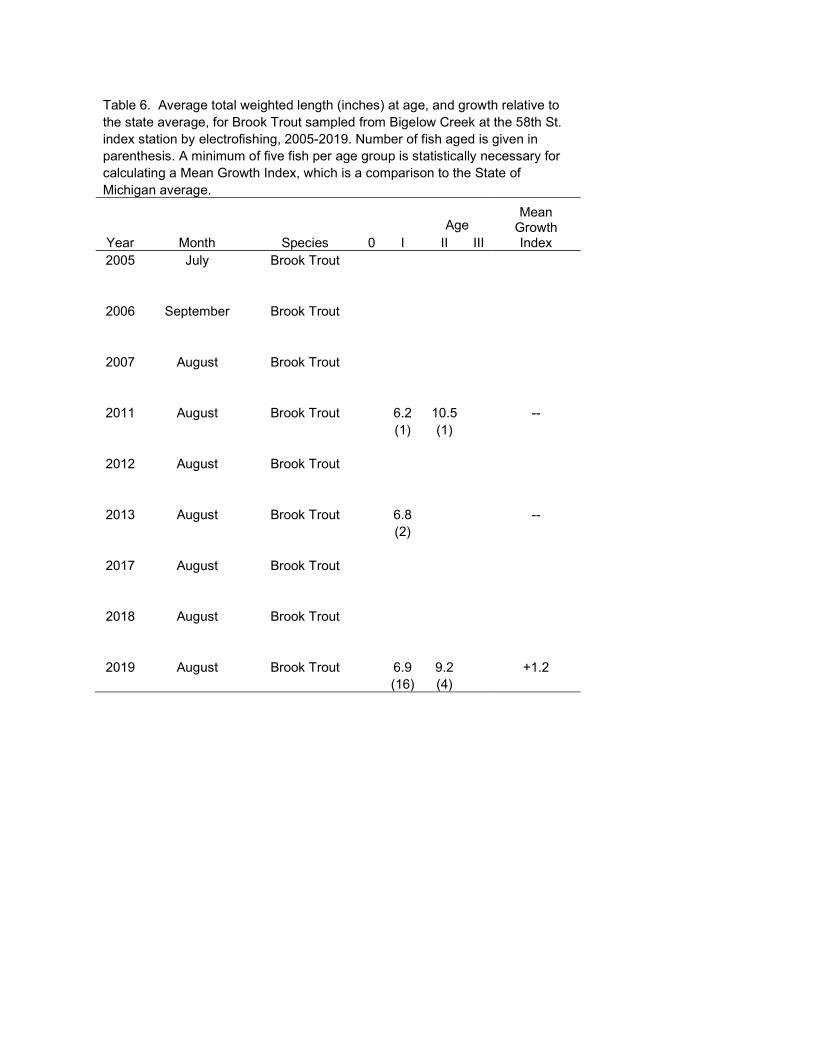
Table 6. Average total weighted length (inches) at age, and growth relative to the state average, for Brook Trout sampled from Bigelow Creek at the 58th St. index station by electrofishing, 2005-2019. Number of fish aged is given in parenthesis. A minimum of five fish per age group is statistically necessary for calculating a Mean Growth Index, which is a comparison to the State of Michigan average. Mean
Growth Index
Age Year Month Species 0 I II III 2005 July Brook Trout
2006 September Brook Trout
2007 August Brook Trout
2011 August Brook Trout 6.2 10.5 --
(1) (1)
2012 August Brook Trout
2013 August Brook Trout 6.8 --
(2)
2017 August Brook Trout
2018 August Brook Trout
2019 August Brook Trout 6.9 9.2 +1.2 (16) (4)

Table 7. Habitat evaluation data from Bigelow Creek at the 58th St. index station, 2007, 2011, 2017. 2007 2011 2017
% Riffle 0.0 0.0 0.0 % Run 96.0 100.0 84.6 % Pool 0.0 0.0 15.4
Average width (ft) 22 20.50 24.3 Average depth (ft) 1.1 1.0 0.9
Max depth (ft) 2.7 3.1 3.1 Discharge (cfs) 21.4 18.9 20.1
Woody cover (sq ft) 5,228 5,541 3,690 Linear wood (ft) 384 270 372
Substrate clay 0.0% 0.0% 0.0%
detritus/silt 29.2% 30.2% 25.5% sand 45.2% 54.5% 59.7%
gravel 18.7% 11.9% 10.7% small cobble 0.5% 0.4% 0.0% large cobble 1.8% 0.0% 0.0%
boulder 0.0% 0.4% 0.0% wood 0.5% 1.3% 2.0% island 4.1% 1.3% 2.0%

Table 8. Bigelow Creek temperature data from the 58th Street station, 2011-2019.
2011 2012 2013 2017 2018 2019
January Minimum 31.9 31.9 31.9 32.0 January Average 35.5 35.1 34.7 34.6
January Maximum 41.5 41.0 40.7 38.8
February Minimum 31.8 31.9 32.0 32.0 February Average 37.1 34.7 35.7 34.7
February Maximum 41.7 40.1 46.8 39.2
June Minimum 54.6 51.8 51.7 53.5 55.6 52.0 June Average 63.4 65.1 63.0 64.3 63.7 61.0
June Maximum 76.3 78.9 73.7 74.7 73.5 73.1
July Minimum 60.3 62.6 56.3 59.1 61.7 58.2
July Average 68.7 70.9 65.1 66.8 66.8 66.9
July Maximum 79.7 82.6 77.6 75.6 73.6 75.0
August Minimum 59.0 56.0 56.4 54.9 59.9 55.7 August Average 65.9 65.2 61.8 63.6 66.5 64.1
August Maximum 75.0 77.1 70.2 73.0 71.6 71.0
December Minimum 33.3 31.9 33.9 December Average 38.5 35.7 38.0
December Maximum 47.8 45.8 42.6
Table 9. Catch from 7/16/2008 MDNR Status and Trends Random electrofishing survey of Cold Creek just upstream of the Bigelow Creek confluence.
Blacknose Dace
Brook Trout
Chinook Salmon
Green Sunfish
Mottled Sculpin
Rainbow Trout
Inch Class
Brown Trout
1 11 7 2 15 4 1 1 8 4 3 13 6 5 4 1 5 1 1 1 6 5 1 7 8 1 9 1
10 11 1
Total: 28 14 8 1 1 24 12
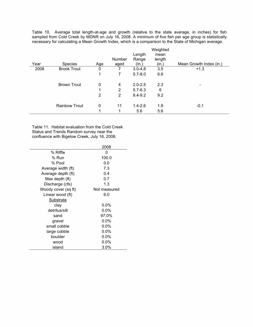
Table 10. Average total length-at-age and growth (relative to the state average, in inches) for fish sampled from Cold Creek by MDNR on July 16, 2008. A minimum of five fish per age group is statistically necessary for calculating a Mean Growth Index, which is a comparison to the State of Michigan average.
Year Species Age Number
aged
Length Range
(In.)
Weighted mean length (in.) Mean Growth Index (in.)
2008 Brook Trout 0 7 3.0-4.8 3.5 +1.3 1 7 5.7-8.0 6.6
Brown Trout 0 4 2.0-2.5 2.3 - 1 2 5.7-6.3 6
2 2 8.4-9.2 9.2
Rainbow Trout 0 11 1.4-2.6 1.9 -0.1 1 1 5.6 5.6
Table 11. Habitat evaluation from the Cold Creek Status and Trends Random survey near the confluence with Bigelow Creek, July 16, 2008.
2008
% Riffle 0 % Run 100.0 % Pool 0.0
Average width (ft) 7.3 Average depth (ft) 0.4
Max depth (ft) 0.7 Discharge (cfs) 1.3
Woody cover (sq ft) Not measured Linear wood (ft) 6.0
Substrate clay 0.0%
detritus/silt 0.0% sand 97.0%
gravel 0.0% small cobble 0.0% large cobble 0.0%
boulder 0.0% wood 0.0% island 3.0%
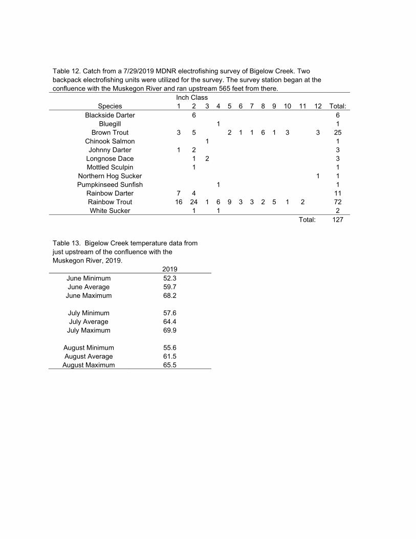
Table 12. Catch from a 7/29/2019 MDNR electrofishing survey of Bigelow Creek. Two backpack electrofishing units were utilized for the survey. The survey station began at the confluence with the Muskegon River and ran upstream 565 feet from there. Inch Class
Species 1 2 3 4 5 6 7 8 9 10 11 12 Total: Blackside Darter 6 6
Bluegill 1 1 Brown Trout 3 5 2 1 1 6 1 3 3 25
Chinook Salmon 1 1 Johnny Darter 1 2 3
Longnose Dace 1 2 3 Mottled Sculpin 1 1
Northern Hog Sucker 1 1 Pumpkinseed Sunfish 1 1
Rainbow Darter 7 4 11 Rainbow Trout 16 24 1 6 9 3 3 2 5 1 2 72 White Sucker 1 1 2
Total: 127 Table 13. Bigelow Creek temperature data from just upstream of the confluence with the Muskegon River, 2019.
2019 June Minimum 52.3 June Average 59.7
June Maximum 68.2
July Minimum 57.6 July Average 64.4
July Maximum 69.9
August Minimum 55.6 August Average 61.5
August Maximum 65.5
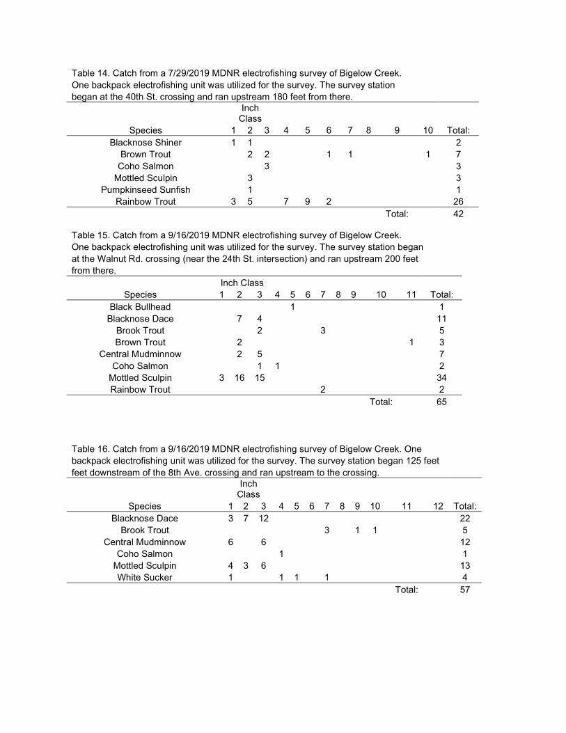
Table 14. Catch from a 7/29/2019 MDNR electrofishing survey of Bigelow Creek. One backpack electrofishing unit was utilized for the survey. The survey station began at the 40th St. crossing and ran upstream 180 feet from there.
Inch
Class Species 1 2 3 4 5 6 7 8 9 10 Total:
Blacknose Shiner 1 1 2 Brown Trout 2 2 1 1 1 7
Coho Salmon 3 3 Mottled Sculpin 3 3
Pumpkinseed Sunfish 1 1 Rainbow Trout 3 5 7 9 2 26
Total: 42 Table 15. Catch from a 9/16/2019 MDNR electrofishing survey of Bigelow Creek. One backpack electrofishing unit was utilized for the survey. The survey station began at the Walnut Rd. crossing (near the 24th St. intersection) and ran upstream 200 feet from there. Inch Class
Species 1 2 3 4 5 6 7 8 9 10 11 Total: Black Bullhead 1 1
Blacknose Dace 7 4 11 Brook Trout 2 3 5 Brown Trout 2 1 3
Central Mudminnow 2 5 7 Coho Salmon 1 1 2
Mottled Sculpin 3 16 15 34 Rainbow Trout 2 2
Total: 65
Table 16. Catch from a 9/16/2019 MDNR electrofishing survey of Bigelow Creek. One backpack electrofishing unit was utilized for the survey. The survey station began 125 feet feet downstream of the 8th Ave. crossing and ran upstream to the crossing.
Inch
Class Species 1 2 3 4 5 6 7 8 9 10 11 12 Total:
Blacknose Dace 3 7 12 22 Brook Trout 3 1 1 5
Central Mudminnow 6 6 12 Coho Salmon 1 1
Mottled Sculpin 4 3 6 13 White Sucker 1 1 1 1 4
Total: 57

Table 17. Catch from a 7/29/2019 MDNR electrofishing survey of the East Branch of Bigelow Creek. One backpack electrofishing unit was utilized for the survey. The survey station began at the 40th Ave. crossing and ran upstream 270 feet. Inch Class
Species 1 2 3 4 5 Total: Blacknose Dace 1 20 8 29
Brown Trout 1 1 Central Mudminnow 1 1
Creek Chub 16 13 6 35 Longnose Dace 2 2 Mottled Sculpin 2 1 3
Pumpkinseed Sunfish 2 2 Yellow Bullhead 1 1 2
Total: 75
Table 18. Catch from a 7/29/2019 MDNR electrofishing survey of the West Branch of Bigelow Creek. One backpack electrofishing unit was utilized for the survey. The survey station began 125 feet downstream of the 40th Ave. crossing and ran upstream to the crossing.
Inch
Class Species 1 2 3 4 5 6 7 8 9 10 Total:
Brown Trout 7 26 2 7 9 6 2 3 1 63 Mottled Sculpin 1 3 4 Rainbow Trout 1 1 2
Total: 69
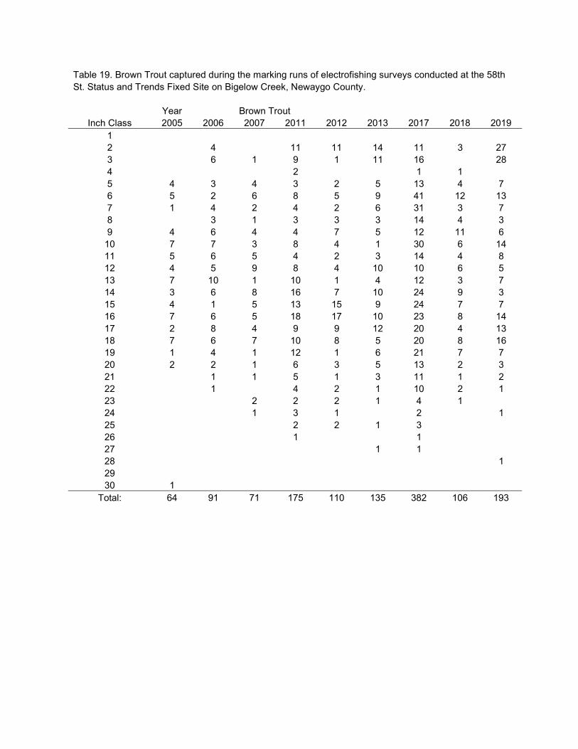
Table 19. Brown Trout captured during the marking runs of electrofishing surveys conducted at the 58th St. Status and Trends Fixed Site on Bigelow Creek, Newaygo County. Year Brown Trout
Inch Class 2005 2006 2007 2011 2012 2013 2017 2018 2019 1 2 4 11 11 14 11 3 27 3 6 1 9 1 11 16 28 4 2 1 1 5 4 3 4 3 2 5 13 4 7 6 5 2 6 8 5 9 41 12 13 7 1 4 2 4 2 6 31 3 7 8 3 1 3 3 3 14 4 3 9 4 6 4 4 7 5 12 11 6
10 7 7 3 8 4 1 30 6 14 11 5 6 5 4 2 3 14 4 8 12 4 5 9 8 4 10 10 6 5 13 7 10 1 10 1 4 12 3 7 14 3 6 8 16 7 10 24 9 3 15 4 1 5 13 15 9 24 7 7 16 7 6 5 18 17 10 23 8 14 17 2 8 4 9 9 12 20 4 13 18 7 6 7 10 8 5 20 8 16 19 1 4 1 12 1 6 21 7 7 20 2 2 1 6 3 5 13 2 3 21 1 1 5 1 3 11 1 2 22 1 4 2 1 10 2 1 23 2 2 2 1 4 1 24 1 3 1 2 1 25 2 2 1 3 26 1 1 27 1 1 28 1 29 30 1
Total: 64 91 71 175 110 135 382 106 193