Embed Size (px)
Citation preview

MICHIGAN ASSOCIATION OF COUNTYDRAIN COMMISSIONERS
Drones: A New Legal Landscape
Kevin A. FanningClark Hill PLC
July 19, 2017macdc.us

FAA TerminologyThe FAA uses two terms:
Unmanned Aerial Vehicle (UAV)
‐ and ‐
Unmanned Aerial System (UAS)
…The FAA never uses the term
•Dronemacdc.us
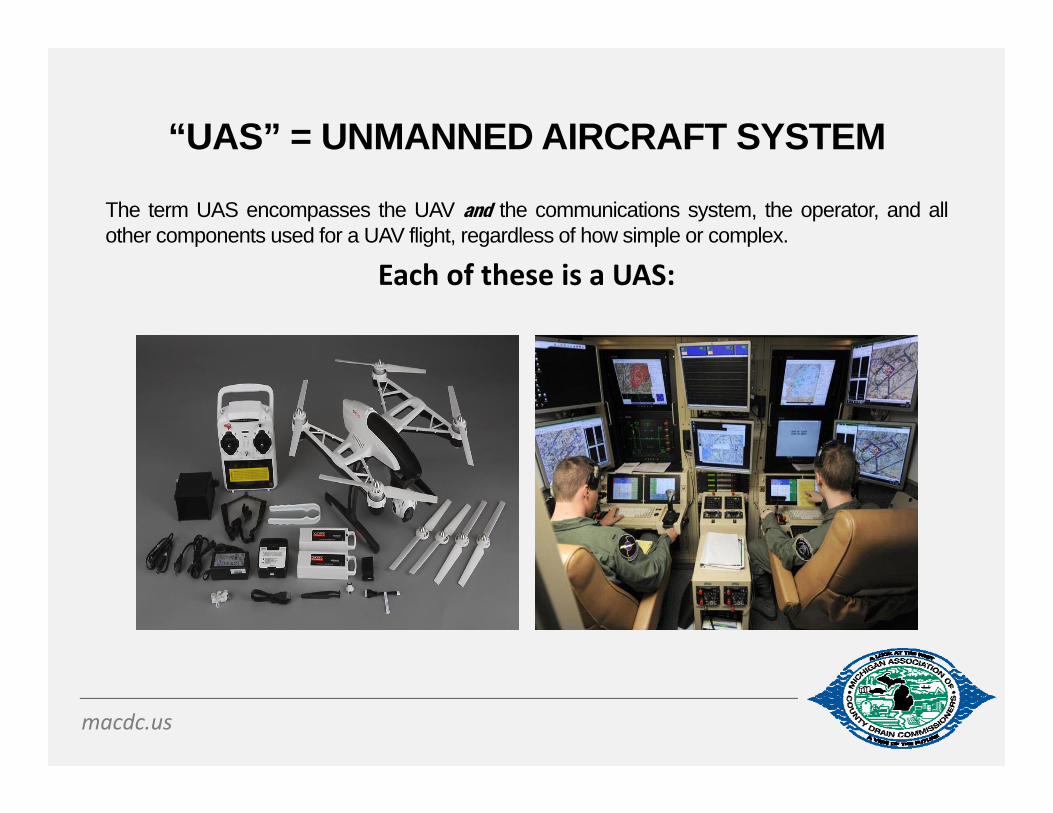
“UAS” = UNMANNED AIRCRAFT SYSTEM
The term UAS encompasses the UAV and the communications system, the operator, and allother components used for a UAV flight, regardless of how simple or complex.
Each of these is a UAS:
macdc.us

UAS PROBLEMS
Drone Hits British Airways Flight April 17, 2016: British Airways Flight BA727 from Geneva wasapproaching Heathrow Airport when a drone struck the front of theaircraft. The plane was 1,700 feet in the air at the time. The Airbus A320landed safely, with none of the 132 passengers and five crew memberson board injured.
Drone caught carrying drugs near US/Mexico borderJanuary 20, 2015: A drone carrying methamphetamine crashed inMexico near the US border. The drone was transporting more than sixpounds of crystal meth when it crashed in a supermarket parking lot inthe Mexican city of Tijuana. According to the DEA, drones are becominga common means to transport drugs over the border.
macdc.us

FAA CHALLENGES
• Roughly 7,000 aircraft fly in NAS at one time. • For the past 40 years, the same computer system has
controlled all that high-altitude traffic (“Host”). • The core system predates the Global Positioning System
(“GPS”)• Host uses point-to-point, ground-based radar. • Controllers can't see anything outside of their own airspace.• When controllers hand off a plane to a contiguous airspace,
it vanishes from their radar.• Air traffic control will not be able to track every airplane with
GPS before 2020. • UAS is not the highest priority.
macdc.us
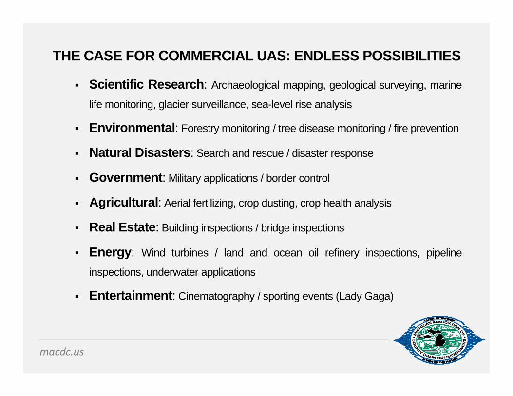
THE CASE FOR COMMERCIAL UAS: ENDLESS POSSIBILITIES
Scientific Research: Archaeological mapping, geological surveying, marine
life monitoring, glacier surveillance, sea-level rise analysis
Environmental: Forestry monitoring / tree disease monitoring / fire prevention
Natural Disasters: Search and rescue / disaster response
Government: Military applications / border control
Agricultural: Aerial fertilizing, crop dusting, crop health analysis
Real Estate: Building inspections / bridge inspections
Energy: Wind turbines / land and ocean oil refinery inspections, pipeline
inspections, underwater applications
Entertainment: Cinematography / sporting events (Lady Gaga)
macdc.us
SAMPLE SECTION 333 EXEMPTION APPLICATION
King-Aerial Inc.: Bridge inspections, flare stack inspection, utility-power generation systeminspections and patrolling, aerial inspection, photography and videography of residentialand commercial real estate, weddings, aerial inspection, photography and videography ofutility infrastructure including but not limited to electrical power lines, wind turbines and celltowers, pipeline inspection and patrolling, filmmaking, cinematography, and videography,precision agriculture with on board sensors, wildlife and forestry monitoring and mosquitoand insect control, aerial surveying, construction site inspection and monitoring, publicentity support operations, aerial imaging for safety, monitoring and comparing work effortsand completion percentages, and security of controlled environment of various sites,aerial video and live video feed to assist with search and rescue operations under theauthority and support of local authority officials, aerial video and photography for publicand private use including television, public events, and cinematography live feed and livenewsgathering, training to persons individually or belonging to both private and publicorganizations to increase awareness and improve safety for current and future UASoperations within the NAS , special events: including high schools. colleges, professionalsports, open air events and fairs, research, risk management and assessment, motionpicture production, surface mining, closed-set filming, disaster and catastrophe events.
macdc.us

PART 107
Part 107 of the FAA Modernization and Reform Act of 2012
(FMRA) became effective August 29, 2016.
Part 107 integrates commercial use of UAS technology into the
National Airspace System (NAS).
A report released by The Association for Unmanned Vehicle
Systems International estimates that in the first decade following
the effective date of Part 107, the expansion of UAS technology
will create more than 100,000 jobs and have an economic impact
of around $82 billion.
macdc.us

PART 107: CRITICAL RULES
The UAS must weigh less than 55 pounds (including payload). Maximum allowable altitude is 400 feet AGL, or 400 feet above a structure. Maximum speed is 100 mph (87 knots). Must keep UAS within visual line of sight (VLOS) of the operator. Must be
unaided sight (i.e., no binoculars). May be aided by Visual Observer during flight (not a substitute for VLOS). Neither operator nor visual observer can be responsible for more than one
unmanned aircraft operation at a time. May not fly over anyone who is not directly participating in the operation, not
under a covered structure, or not inside a covered stationary vehicle. Flying only allowable during daylight hours (or in twilight; 30 minutes before
official sunrise to 30 minutes after official sunset). If UAS is 55↑ lbs, follow Part 333 of FMRA (Certificate of Authority). Better
yet: call counsel.
macdc.us

PART 107: ADDITIONAL RULES
Operator must avoid manned aircraft and never operate in a
careless or reckless manner.
Minimum weather visibility is three miles from closest control
station.
No operations from a moving vehicle are allowed unless
flying over a sparsely populated area.
Operations in Class G airspace are allowed.
No operations in Class B, C, D and E airspace.
macdc.us

HOW HIGH IS 400 FEET AGL?
macdc.us

PART 107: PILOT CERTIFICATION PROCESS
To operate small UAS under Part 107, need a remote pilot airmancertificate with a small UAS rating, or be under the direct supervision of aperson who holds such a certificate (a “remote pilot in command”).
To obtain a remote airman certificate, a person must: be at least 16 years old. Must pass an initial aeronautical knowledge test at an FAA-approved
knowledge testing center, OR If a person already has a Part 61 pilot certificate (other than a
student pilot certificate), must have completed a flight review in theprevious 24 months and take a small UAS online training courseprovided by the FAA.
Complete a security background check. Temporary certificate issued by FAA within 10 business days after
receiving a completed application.
macdc.us
UAS LEGAL RISKS
macdc.us

UAS RISK MANAGEMENT: PROBLEMS TAKING FLIGHT
UAS Litigation
FAA Enforcement Actions
Invasion of Privacy
Trespass
Property Damage
Negligence
Product Liability
macdc.us

PRIVACY UNDER PART 107
• Part 107 acknowledges that certain legal aspectsconcerning sUAS are best addressed at state and locallevels.
• Part 107 yields to all local statutes that apply to a sUASoperation and strongly encourages all UAS pilots tocheck local and state laws before flying.
• This includes state privacy laws.
macdc.us

PRIVACY – FEDERAL LAW
First Amendment • Taking photographs or video of things plainly visible from public spaces is
protected by the First Amendment. Iacobucci v. Boulter, 193 F.3d 14, 24-25 (1st Cir. 1999); Smith v. City of Cumming, 212 F.3d 1332, 1333 (11th Cir. 2000)
Fourth Amendment• No privacy right in surveillance over high-fenced backyard because anyone flying
over could glance down and see what the officers observed. Florida v. Riley, 488 U.S. 445, 451-52 (1989); California v. Ciraolo, 476 U.S. 207, 215 (1986).
• Long term surveillance with modern technology may violate reasonable expectations of privacy. U.S. v. Jones, 132 S. Ct. 945, 964 (2012).
Federal Trade Commission (Consumer Protection)• FTC protects privacy and data security and prohibits "unfair or deceptive acts or
practices in or affecting commerce[.]" 15 U.S.C. § 45(a)(1)(FTC Act, Section 5).
macdc.us

TRESPASS/NUISANCE
“Intrusion Upon Airspace”
• Most states follow U.S. v. Causby, 328 U.S. 256 (1946) to analyze property-based challenges to intrusions upon airspace (military base; 83 feet; dead chickens; P wins $ as a taking).
• Causby factors: (1) whether the aircraft flew directly over P’s land; (2) the altitude and frequency of D’s flights; and (3) whether D’s flights directly and immediately interfered with P’s use and enjoyment of the land.
• Causby analysis for UAS is a square peg/round hole• e.g., Not clear what happens above 83 feet (Causby rule) up to 500
(Class G airspace ceiling)• Not clear if UAS is a true “nuisance”
macdc.us

STATE LAWS GOVERNING UAS
State and local government - health, safety, and welfareShould Be No FAA Preemption (Express or Implied)
[Despite FAA’s NAS exclusive jurisdiction]
45 states have laws using the word “drone” or “UAS” peeping tom/voyeurism laws Nuisance and trespass laws Zoning and Land use laws Requiring warrant before using drones for surveillance Prohibitions on using drones for hunting or fishing, or to
harass someone who is hunting or fishing Prohibitions on attaching weapons to drones
macdc.us

MICHIGAN
• Although various states (CA, LA, OR, NV) have a drone privacy law to protect property owners, Michigan has not yet joined these states that have enacted “drone privacy laws.”
• Yet – Michigan has certain laws that regulate drones, including the prohibition of drone use while hunting or fishing, or to disturb those who are hunting or fishing.
macdc.us

MICHIGAN - COMMON LAW PRINCIPLES
Do landowners have a right to privacy in the airspace above their residences?
Yes. The US Supreme Court has held that property owners have a reasonable expectation of privacy that extends into the air above. It extends roughly 100 feet, although there is no bright line test regarding an exact distance.
Can the homeowner shoot down the UAS (drone)?
No. A UAS is defined as an “aircraft” and it is illegal to shoot an aircraft under FAA regulations. In addition, several so-called “drone slayers” have been charged with criminal activity for shooting down drones under state or local laws. Some have beaten the charges.
macdc.us

MICHIGAN
Might there be a criminal ramification for this UAS (drone) Operator for looking inside a home?
Potentially…
• Under the MI penal code, the term “disorderly person” includes voyeurism/peeping Tom behavior
• A camera on a UAS is like the operator appearing in the homeowner’s yard and peeping in the living room
• Likely need clear proof that video was taken• Much tougher case if there was no camera (mere nuisance)
macdc.us
CITY OF DEWITT - ORDINANCE NO. 2015-02
Section 1. The purpose of Ordinance No. 2015-02 is to allow the City of DeWitt to regulate the operation of unmanned aircraft in the City of DeWitt.
Section 2. Operation of any unmanned aircraft.A. Definitions:1. “Unmanned aircraft” means an aircraft that is operated without the possibility of direct human intervention from within or on the aircraft. The term unmanned aircraft includes drones. The term “unmanned aircraft” does not include (1) a glider or hand-tossed small unmanned aircraft that is not designed for and is incapable of sustained flight; (2) a small unmanned aircraft that is capable of sustained flight and is controlled by means of a physical attachment, such as a string or wire.2. “Public Gathering Space” means any structure, enclosed area or other demarcated space used for the assembly of persons in the open air, including, but not limited to, amusement parks, stadiums, athletic fields, automotive speed ways, aviation fields, band stands, beach enclosures, grandstands, observation platforms, outdoor public swimming pools, outdoor theaters, race tracks, reviewing stands, street festivals or parade routes.
macdc.us

CITY OF DEWITT - ORDINANCE NO. 2015-02
Section 2. B. Regulations:No person, firm or corporation shall operate any unmanned aircraft so as to interfere with the privacy, safety, peace or repose of persons or endanger the health of another, recklessly, carelessly or in violation of Federal law, including but not limited to the following regulations:1. Operation of the unmanned aircraft shall be completely prohibited within 500 feet of a school, police investigation, fire, traffic accident, medical emergency, fire investigation, Public Gathering Space, or such place that may endanger person or property or interfere with persons discharging their public duties.2. No unmanned aircraft shall be operated directly over any person who is not involved in the operation of the unmanned aircraft, without such person’s consent; or directly over property that the operator does not own, without the property owner’s consent, and subject to any restrictions that the property owner may place on such operation;3. The unmanned aircraft shall not be operated outside the visual line of sight of the operator.4. An unmanned aircraft shall not be operated within 500 feet of any electric generating facility, substation or control center, or within 100 feet of any electric transmission facility, or within 25 feet of any electric distribution facility or of any overhead wire, cable, conveyor or similar equipment for the transmission of sounds or signal, or of heat, light or power, or data, upon or along any public way within the City, without the facility or equipment owner’s consent, and subject to any restrictions that the facility or equipment owner may place on such operation;5. The operation of unmanned aircraft will be for recreational purposes only.
macdc.us

UAS PRIVACY – FAA BEST PRACTICES
The FAA publishes drone safety guidance online at www.knowbeforeyoufly.org. The FAA has also published “UAS Privacy Best Practices” on the faa.gov website. FAA’s voluntary privacy guidelines:
Tell others before taking pictures or video of them. Don’t violate others’ privacy by taking pictures, video, or gathering sensitive
data, unless you’ve got a very good reason. Don’t fly over other people’s private property without permission. Don’t gather personal data for no reason, and don’t keep it for longer than
you think you have to. If you keep sensitive data about other people, secure it against loss or theft. If someone asks you to delete personal data that you’ve gathered, do so,
unless you’ve got a good reason not to. If anyone raises privacy, security, or safety concerns with you, try and listen
to what they have to say, as long as they’re polite and reasonable about it. Don’t harass people with your drone.
macdc.us

GOVERNMENTAL USE
TWO OPTIONS FOR PUBLIC ENTITY (i.e., UNIVERSITY) AND GOVERNMENTAL AGENCY USE: Follow the same requirements and operating rules for commercial users
under Part 107; or Apply for blanket public Certificate of Authorization (COA) which allows
flights of public aircraft at or below 400 feet in Class G airspace Only governmental entities (including public colleges and
universities) can receive a COA for public aircraft operations Public aircraft operations must be conducted for a governmental
function FAA vets the application for safety and thoroughness If approved, usually limited to two years, limited by time of day,
certain blocks of airspace
macdc.us
DRONES AND EASEMENTS• Utilities have largely replaced expensive helicopter inspections with low‐cost drones.• The use exercised by easement holder must be reasonably necessary to the proper enjoyment of
the easement with minimal burden to the landowner. Blackhawk Dev. Corp. v. Village of Dexter, 700 N.W.2d 364, 369 (Mich. 2005); Little v. Kin, 664 N.W.2d 749 (Mich. 2003).
• An easement granting access to or a right of way over certain property also carries the incidental right to reasonably use the air over the property. Grinnell Bros. v. Brown, 171 N.W. 399, 401 (Mich. 1919). The extent of these rights is determined by the language of the easement and the burden that their use places on the servient estate.
• An easement‐holder may take advantage of technological advances so long as the improvements are necessary for the effective enjoyment of the easement and avoid unreasonably increasing the burden on the land. Rolland v. International Transmission Co., No. 274411, 2008 WL 2038025 at *1‐4 (Mich. App. 2008) (stating that because “[s]cience and technology do not stand still,” it would be reasonable to expect that technical aspects of utility easements would change over time) (citing Detroit Edison Co. v. Zoner, 163 N.W.2d 496, 498 (Mich. App. 1968)). New technology must be used reasonably and in a manner consistent with the purpose of the easement but does not have to be contemplated by the terms of the original grant. See also Heydon v. MediaOne, 739 N.W.2d 373, 380‐81 (Mich. App. 2007) (finding that adding cable lines to electrical utility poles was reasonable).
• The FAA strongly encourages all UAS pilots to check local and state laws before gathering information through remote sensing technology or photography
• FOLLOW FAA GUIDANCE AND OTHER GOVERNMENTAL PRIVACY GUIDANCE
macdc.us
LOOKING TO THE FUTURE:UAS TRAFFIC MANAGEMENT (“UTM”)
UTM = air traffic management in uncontrolled (Class G) airspace for UAS operationsNASA: study in 4 phases at 6 federal sites. Issues:• segregation of NAS (G sections for UAS only)?• G airspace altitude corridors for UAS only?• Carve up G based on UAS levels of technology
and/or pilot sophistication?• Segregate G sections based on GPS avoidance
sensing technology only? • FAA Control? Private Control?
macdc.us

DEDICATED SHORT RANGE COMMUNICATIONS (DSRC)
• DSRC is a two-way short-to-medium range wireless communications capability that permits very high data transmission critical in communications-based active safety applications.
• Vehicle safety applications that use vehicle-to-vehicle (V2V) and vehicle-to-infrastructure (V2I) communications need secure, wireless interface dependability in extreme weather conditions, and short time delays; all of which are facilitated by DSRC.
• The Federal Communications Commission (FCC) allocated 75 MHz of spectrum in the 5.9 GHz band for use by Intelligent Transportations Systems (ITS) vehicle safety and mobility applications.
• DSRC based communications is a major research priority of the Joint Program Office (ITS JPO) at the U.S. Department of Transportation (U.S. DOT) Research and Innovative Technology Administration (RITA).
• UAS use of DSRC is under intensive study by these agencies together with all stakeholders.
macdc.us