Embed Size (px)
Citation preview

MARYLAND HISTORICAL TRUST NR-ELIGIBILITY REVIEW FORM
NR Eligible: yes _
no
r' Potential Phillips Army Air Field Property Name: _H_is_to_n_· c_D_is_tn_·c_t ________ lnventory Number: HA -2 0 3 B Address: DSHE Building 5650 City: Aberdeen Proving Ground Zip Code: 21005
County: USGS Topographic Map: ------ -----Harford Perryman
Owner: Department of the Army, Commander USAGAPG
Tax Parcel Number: Tax Map Number: Tax Account ID Number: --- ---- -------Project: f? ~~~Sri'>' ~ i"()-\ 1..t( \:t-'c_\.o..,/oc)Y f:\k\\. \ .~, \ Agency: ..... A"--3...,mu.=C)'-+--------------Site visit by MHT Staff: X no _yes Name: Date: ----------- ---- ----Eligibility recommended Eligibility not recommended ~
Criteria: A B C D Considerations: A B ------- c D E F G X None
Is the property located within a historic district? 2L_ no _ _ yes Name of district: ------------
Is district listed? ~no _yes Determined eligible? ~no yes District Inventory Number: -----
Documentation on the property/district is presented in: Frank J. Sclueppati., Kelly Nolte, Stacey L. Gri.ffm, Robert Hanley and Christine M. Longiaru. 2002 Cultural Resources Inventory and Evaluation for Proposed Automotive Tednology Evaluation Facility. and National Register Evaluation for Proposed Historic Districts, Phillips Anny Air Field, Aberdeen Proving Ground, Harford County, Maryland. Panamerican Consultants, Inc., Buffalo, New York.
Description of Property and Eligibility Determination: (Uu contin11ation sheei if necessary and attach mnp and photo)
Introduction
Panamerican Consultants, Inc. (PCI), under a cooperative agreement with the U.S. Army Medical Research and Materiel Command, conducted a cultural resources inventory and impact assessment for a proposed Automotive Technology Evaluation Facility (ATEF) to be located at Phillips Army Air Field (PAAF) for Aberdeen Test Center (ATC), Aberdeen Proving Ground, Harford County, Maryland. An evaluation was also conducted to assess PAAF's eligibility for listing in the National Register of Historic Places (NRHP) as a National Register Historic District.
EligibUJty not recommended '(} ------ARYLAND HISTORICAL TRUST REVIEW
ligibllity recommended __ riteria: _A _ _ B_C D Considerations: _A_B_C_D_E_F_ G _None
ommenu: ~:;i.;;~1.-_.:._:=--i,._~..;..i...~ ........... ---------- - - - - -------------1

MARYLAND IDSTORICAL TRUST NR-ELIBILITY REVIEW FORM
- Continuation Sheet No. 1: Potential Phillips Army Air Field Historic District
L, /. .
ATC tests are currently conducted at the Churchville Test Track and the Munson test track, the original Phillips Air Field site. These test tracks no longer meet the requirements for advancing designs and new equipment, and the proposed ATEF would allow the testing of high-speed vehicles on a curved track with a capability of changing driving conditions. The proposed three-lane track will be 4.54 miles, constructed around PAAF, the Fire Training Area, and the Foreign Vehicle Storage area. Forty-five feet wide, the track will include a ten-foot shoulder with an inside clear zone of 100 feet and an outside clear zone of two-hundred feet with a buffer of existing vegetation and mature tree lines beyond. Construction of the proposed ATEF will impact a total of 51.5 acres around PAAF. At the time of the survey, plans had not been solidified as to the needs for additional support structures and features to monitor and administer testing for the new track. It remained unclear whether they would build a new operation center or rehabilitate existing structures, and if additional features, such as radio systems, signage, communication/data cabling and fiber optics, might be needed and/or feasible.
As the tenant of the current PAAF and adjacent Foreign Vehicle Storage area since the 1990s, ATC also maintains several testing sites:
[Facilities] at the Phillips Army Air Field at Aberdeen Test Center (ATC) include alert, refueling, fireguard services, an air traffic control tower with all weather capabilities/day and night. The runways are capable of landing any aircraft, as are the ramp/hard surface areas. Drop zones include personnel, container delivery system, and standard training bundles. Automotive Testing Capabilities include steering and handling, lane change/J turns, brake testing in all weight classes and at high speed. Warfighter training opportunities include training exercises support, training facilities, in partnership with Naval Air Warfare Center at Patuxent, MD [GlobalSecurity 2002].
Serving as the Department of Defense's lead ground vehicle test facility, ATC continues to test automobile safety, performance, and reliability of ground vehicles for the government and private industries. The buildings and structures within the survey area serve as support facilities and alterations are made for adjustments related to technological advancement.
The survey area consisted of several associated areas, including PAAF's structures and runways, the University of Maryland's Fire Training area, ATC's Foreign Vehicle Storage area, Bomb Storage/Ammo Dump Areas No. 2 and No. 3, the Ammunition Shipping, Receiving and Magazine Loading Plant and Receiving Station, and the Aviation Arms Road rail spur linking these areas.
Aberdeen Proving Ground
Aberdeen Proving Ground (APG) was established by the Ordnance Department in 1918 to assume the testing functions of Sandy Hook Proving Ground, New Jersey (Grandine and Cannan 1995:A-6). APG is located in Harford and Baltimore Counties, Maryland:
along the western shore of Chesapeake Bay and encompasses approximately 39,000 acres. Acquisition of land for the establishment of the Aberdeen and Edgewood Arsenal areas began in 1917. Aberdeen Proving Ground is a primary facility for planning and conducting developmental and post production tests of weapons, weapons systems, rocket and missile systems, munitions and their components, survey and acquisition equipment, armor plate, combat vehicles, other general and special purpose vehicles, ancillary automotive equipment, combat engineer equipment, and troop support equipment. The facility provides administrative and logistical support and technical advice

MARYLAND IDSTORICAL TRUST NR-ELIBILITY REVIEW FORM
Continuation Sheet No. 2: Potential Phillips Army Air Field Historic District
to supported installation activities, other governmental agencies, and to various tenants within the Aberdeen and Edgewood installations. Air fields were constructed within both areas. Phillips Field, in the Aberdeen area, was originally located near the former Michaelsville community in 1921 [SOW 2000].
During World War I, work at the new proving ground included both acceptance and experimental testing of weapons and ammunition (Grandine and Cannan 1995). During the inter-war years, APG continued some research and development of powder, projectiles, bombs, and other artillery. The Army established other proving grounds to keep pace with increased wartime production for World War II, but APG served as the Army's principal ordnance research and testing facility and was recognized as the Ordnance Research Center in November 1943 (Grandine and Cannon 1995:A-7). Materiel testing and research continued through the Cold War era and remains a component within the installation's primary mission that continues to change with advancing technology.
Development of Phillips Army Air Field
With the country's entrance into World War I in April 1917, the United States was asked to supplement allied air strength in France with 4,500 American aircraft, 5,000 pilots, and 50,000 mechanics by 1918. With only three dozen pilots and no combat worthy planes, the U.S. Army Signal Corps Aviation Section was not prepared to supplement the air support needs of American allies. In his book Where Eagles Land, Jerrold E. Brown (1990) writes that in response, the United States government began immediate plans to expand its aviation service, closing the air power gap between itself and the European combatants. Responding quickly to the demands for war preparation, Congress appropriated the funds for aviation purposes: to purchase and rent land; for the construction and maintenance of permanent buildings, barracks, and quarters; drainage; water; and electrical power for aviation schools, posts, experimental stations, and proving grounds (Brown 1990:36).
During World War I, the Army acquired thirty-three tracts of land for major training fields, developed five landing fields on posts where missions other than aviation were primary activities, acquired numerous auxiliary fields and expanded all of the pre-war fields. The Army also developed four balloon fields, four acceptance parks, five general aviation supply depots, three general aviation depots, special schools and concentration camps (Brown 1990:4 7). Brown also notes that the geographical distribution of wartime installations reflects the organization of those facilities for a European war as:
• Training fields were concentrated primarily along the Gulf, from Florida to California;
• Two concentrations of facilities existed on the eastern seaboard at Long Island and near Washington, D. C. served units and processed equipment moving toward the embarkation ports and provided the limited aerial defense needs of the vital industrial centers on the coast; and
• A third complex of fields existed in the midwestern states east of the Mississippi and served a variety of purposes: training, depots, and experimental work (Brown 1990:48).
Aberdeen Proving Ground was situated so the design and testing of ordnance materiel could be carried out in close proximity to the nation's industrial and shipping centers. As one of the permanent installations completed during World War I, Aberdeen Proving Ground was to include air fields for both the Aberdeen and Edgewood areas.

MARYLAND IDSTORICAL TRUST NR-ELIBILITY REVIEW FORM
Continuation Sheet No. 3: Potential Phillips Anny Air Field Historic District
During the initial development phase of Army air fields, Congress passed the Army Appropriation Act of 1917 approving the purchase of two aviation fields, one in California and a second field to be selected to further expand the Signal Corps aviation section. With requirements for prospective sites in hand, an appointed board narrowed the list of possible sites for the location of an aviation school and flying field to Aberdeen, Maryland and Langley Field, Hampton, Virginia (Brown 1990:28). Initially passed up, APG was finally approved for a flying field by 1918.
While military aviation schools were essential, Air Services leaders sought air fields to serve the multiplicity of other needs (Brown 1990:65). The Army established a number of flying fields where aviation was not the primary activity but provided flying time for pilots, served as landing fields for aircraft during joint exercises or demonstrations, doubled as airway stations, and, of course, tested weapons. Brown states that:
During the war, the Army had established a number of flying fields at regular posts and National Army cantonments, where aviation was not the primary activity. Pope Field at Camp Bragg, North Carolina; Godman Field at Camp Knox, Kentucky; and Phillips Field at Aberdeen Proving Ground, Maryland, were the most important of these. The former two served as artillery coordination training, and the latter for ordnance testing [Brown 1990:65).
Air field development began in 1918 when the first Phillips Army Air Field was built east of the Main Front near Spesutie Narrows (Grandine 1996:1-111-66). Four hangars and support facilities were associated with the air field. In July 1918, the 271st Aero Bombing Squad arrived at APG prior to going overseas (Grandine 1996:1-111-66). Consisting of about a dozen light planes, the 271 51 Aero Squadron is considered America's first bombing unit (Harford Democrat 1967: 11 ). The first aerial bombs were tested from Handley-Page bombers at APG. There were only two such early bombers in the United States (Harford Democrat 1967:11 ). At that time, APG's firing ranges included a water battery, railroad mount battery, bombing range, mobile artillery battery, heavy artillery battery, trench warfare range, anti-aircraft range, two detonating ranges and a plate range (Grandine et al. 1996:1-111-65; NARA n.d.).
Phillips Army Air Field's major mission was air support to facilitate materiel testing, with nearby complexes providing amenities for the storage, distribution and assemblage of ordnance for testing. Bomb tests were "weather-permitting," restricted to days when skies were clear to avoid inaccuracy. As Bombers were loaded with ordnance for testing at one of APG's many ranges and observers watched from a concrete shelter located a mile from the impact area. During World War II, for example, B-23 bombers were loaded with 2,000 lb and 4,000 lb "Blockbuster" bombs. The bombers left PAAF for a range approximately ten miles from the installation's main front. The B-23s climbed to approximately 10,000 feet and then opened the bomb bay doors to unload, aiming for a 20-foot "X" target.
The air field was used by aircraft that supported the creation of bombing tables, by which the techniques these tables provided were a means of improving the adequacy of aerial bombing [APG n.d.).
In 1940, the government began efforts to acquire new land for the expansion of APG. Five thousand acres of fertile farmland, primarily sugar corn crops, were purchased for a new air field and for aerial bomb testing (Baltimore Sun [BS], 24 September 1941 ). Residents in the path of the proposed runways were forced to move out by October 1 of the same year. In 1942, the Army abandoned the original air field to build the present Phillips Air Field (Grandine 1996:1-111-87) in the northeast corner of Aberdeen Proving Ground. Operations at the old air field were interfering with other activities at the post (BS,

MARYLAND IDSTORICAL TRUST NR-ELIBILITY REVIEW FORM
Continuation Sheet No. 4: Potential Phillips Army Air Field Historic District
14 August 1941 ), as advancing aircraft technology changed the physical aspects of air field requirements.
With faster speed and larger weight considerations, the new all-metal, high-speed aircraft required longer runways, shallower glide paths, and much stronger pavement surfaces, all of which added to the cost of air field construction and maintenance. Increasingly complex components also required additional shop space, also adding to the housing loads in aircraft hangars ... Most of the new construction activity centered on runway and apron improvements that were necessary to support the immensely heavy new aircraft. Pavements able to withstand 120,000 lb. gross loads were required [Pedrotty et al. 1999:3-16; 4-15, 16].
In response, Phillips Air Field relocated to accommodate longer runways, with additional support facilities and structures necessary for the new breed of aircraft bomber planes being used for munitions testing. After the new air field was completed, the old field was converted for use as a simulated rugged battlefield terrain automotive testing track. Installation history states that:
The Phillips Army Air Field constructed in 1918 was named in memory of First Lieutenant Wendell K. Phillips who was killed in an aircraft accident at Aberdeen ... and that a new air field, capable of accommodating larger aircraft being used for bomb testing was constructed in 1942 and the Phillips' name was maintained [APG n.d.].
Phillips Army Air Field Potential Historic District Assessment
In 1996, Grandine et al. (1996:1-111-23) noted that the current Phillips Army Air Field (Buildings 1059-1066 and Building 1078) demonstrated the typical design of air fields constructed at installations during WWII, and that the Air Field needed further investigation as a potential historic district. Grandine et al. also listed the eligibility of the Foreign Vehicle Storage area's buildings (Buildings 1080-1091, Building 1095 and Building 1096) as undetermined (Grandine et al. 1996:1-111-23).
Based on Grandine's findings, PCI assessed a total of 42 buildings within five associated areas and the surrounding landscape for evaluation and determination of eligibility for listing on the NRHP as a National Register Historic District(s). (See Figure 1 for a list of the buildings surveyed). Eligibility determinations for the National Register of Historic Places were judged using National Register Criteria A, B, C, and D, as specified in 36 CFR Part 60. Located within a restricted area of the Aberdeen Area, PAAF and some of the associated complexes were off-limits for close inspections and photography and activities in some buildings were not disclosed.
Architectural evaluations included nine buildings at PAAF, which had been previously recommended for further investigation as a potential Historic District (Buildings 1059, 1060, 1061, 1062, 1063, 1064, 1065, 1066, and 1078 (Grandine et al. 1996). However, research into real estate records of PAAF revealed an inter-connected network of adjacent complexes for receiving, assembling, storing and loading munitions for testing purposes during World War II that would dictate a potential historic district beyond the immediate boundaries of PAAF. All of these areas were surveyed to ascertain the presence and integrity of a potential Phillips Army Air Field Historic District. The inter-connected network of five individual areas revealed during PCl's National Register evaluation for a potential PAAF Historic District include:

MARYLAND IDSTORICAL TRUST NR-ELIBILITY REVIEW FORM
Continuation Sheet No. 5: Potential Phillips Army Air Field Historic District
Area I Phillips Army Air Field (historically known as the A. C. Quadrant) with its associated buildings and runways, including the University of Maryland's Fire Training Facility;
Area II Aberdeen Test Center's (ATC) Foreign Vehicle Storage Area (FVS), historically known as the "Ordnance Quadrangle");
Area Ill Connecting rail spur running between the Ammunition Loading and Receiving Plant to the Foreign Vehicle Storage area;
Area IV Bomb Storage/Ammo Dump Areas No. 2 and No. 3, and
Area V The Ammunition Loading and Receiving Plant with Receiving Station and Storage Area.
The location of the individual facilities delineates the boundaries for a potential Phillips Army Air Field Historic District. Following the pattern of established roads, the boundaries include: Bush River Road north and west of the air field; Tank Access Road south of the air field; and Airbase Loop Road to the east of the air field, with a tangent of Aviation Arms Road from Airbase Loop Road to Michaelsville Road (Figure 2).
Historically referred to as the "A. C. Quadrangle," Area I of the potential PAAF Historic District contains the original structures at the landing field which were completed by 1943. The Air Field consists of a fire station, storage buildings, aircraft hangar, control tower, several support utility buildings, taxiways and runways. Initially, a concentration of buildings positioned north of the hangar complex across Bush River Road housed additional air field support activities, including burning activity (Figure 3) (APG 1946a). These structures are no longer extant, and now only an asphalt pad remains from the entrance into the complex. Adjacent to this area to the east are several metal buildings enclosed by a chain-link fence. Originally open space within the landscape of PAAF; this enclosed area is leased to the University of Maryland as its Fire Training Facility. No structures are located west or south of the air field within the survey area.
Area II of the potential PAAF Historic District was initially known as the "Ordnance Quadrangle" and is now the Aberdeen Test Center's Foreign Vehicle Storage area. This complex of structures to the east of PAAF is linked to the air field by loading aprons. The complex originally housed the bomb assembly and loading plant within the Ordnance Quadrangle (Building 1089; Figure 4). Little history is available on the Ordnance Quadrangle, but research revealed that this complex was the last stop before testing of ordnance could commence. Munitions were loaded from the Ammunition Receiving and Loading Magazine Plant (Building 714), sent by rail to the Bomb Assembly Plant (Building 1089), then assembled and loaded onto aircraft taking off from PAAF. The munitions were tested in the bombing fields south of the installation's main front (Figure 5) (APG 2002). Any ordnance not used would have been stored in the adjacent bomb storage areas and nearby earthfast igloos (Buildings 1088, 1089, Bomb Storage Area No. 2).
A connecting rail spur, Area Ill of the potential PAAF Historic District, runs east from ATC's Foreign Vehicle Storage area parallel with Aviation Arms Road (Figure 6). This spur links ATC with the Ammunition Receiving and Loading Magazine Plant at the intersection of Aviations Arms Road and Michaelsville Road and initially connected to the main rail line on the east side of Michaelsville Road. No longer used, the rail spur has been abandoned, twisting in some sections, taken up in others, and no longer connects to the installation's main rail line.

MARYLAND IDSTORICAL TRUST NR-ELIBILITY REVIEW FORM
Continuation Sheet No. 6: Potential Phillips Army Air Field Historic District
Two bomb storage areas are located across from the ATC area and is Area IV of the potential PAAF Historic District. Adjacent to the rail spur is Bomb Storage/Ammo Dump No. 2 on Aviation Arms Road (Buildings 712, 712A, 715, 718). The area originally held two storage units with loading aprons at the ends of an east-west axis road, with a secondary rail spur running through this area from the Aviation Arms Road rail spur (Figure 7) (APG 1946b ). Bomb Storage No. 2, enclosed by a chain link fence consists of several replacement storage buildings built from 1966 to 1995. This area is currently used as storage for range residue. Bomb Storage/Ammo Dump No. 3 is located opposite ATC on the comer of Airbase Loop and Aviation Arms Roads (Figure 8). The fenced-in area is an open area with four loading aprons. No longer serving as storage or a dumping facility, the area is a flat gravel lot.
Further east along the rail spur is Area V of the potential PAAF Historic District, the Ammunition Shipping, Receiving and Magazine Loading Plant and Receiving Station and storage (see Figure 6). The Receiving Station is an open-air loading ramp with storage shed adjacent to the spur (Buildings 714A, 714D). The ramp sits west of the Ammunition Shipping, Receiving and Magazine Loading Plant (Building 714). Constructed as a ready magazine, munitions and supplies were distributed from this warehouse type structure adjacent to the installation's main rail line and Aviation Arms Road spur. Originally, the areas were interdependent, but the ramp or plant no longer serves their historical functions along the abandoned rail line.
Structure Assessment of the Five Areas within the Potential PAAF Historic District
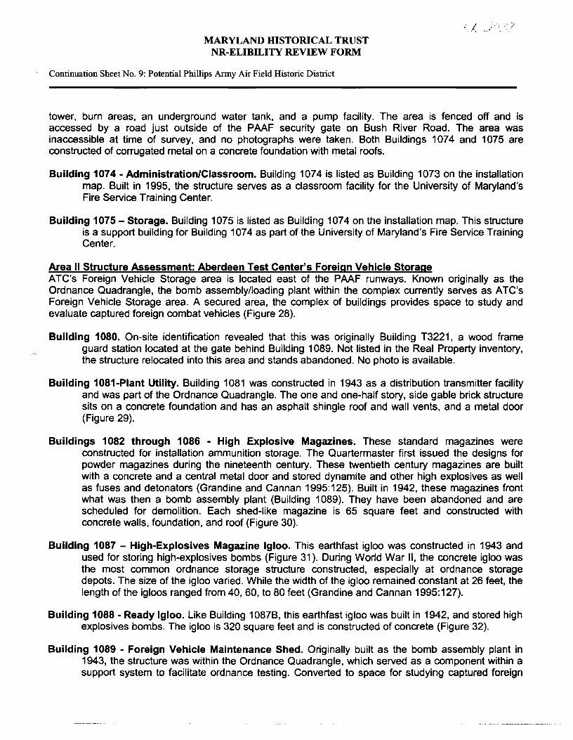
Area I Structure Assessment: Phillips Army Air Field A brief capability statement of Aberdeen Test Center's activities at PAAF describes the air field support facilities located on the northern side of the airport.
With 18 associated buildings and structures, the area contains 35,700 square feet of maintenance hangar and associated warehouse/flight support office space and approximately 150,000 square feet of apron and ramp area, helicopter parking positions, the air traffic control tower, a Fire Station, and automobile parking. On the southern side of the airport, there are two aprons consisting of approximately 470,000 square feet of apron area capable of supporting air cargo operations (Figures 9 and 10) (GlobalSecurity 2002).
A their 1999 report Historical and Architectural Overview of Military Aircraft Hangars, Pedrotty et al. discuss those properties, which contribute to an air field's flying mission stating that:
Such properties, referred to as associated structures include all aviation facilities other than hangars. These structures have an essential role in a base's air mission, and therefore should be considered an important part of any air field context.
The air field landscape includes surface structures such as runways, overrun pavement, taxiways, parking aprons, arm and disarm pads, and various navigational aids and air traffic control facilities. Views across these surfaces once played an important role in the placement of aviation-related buildings. Older control towers are found in prominent locations along flight lines (such as on the corners of aircraft hangars) for commanding views of the airspace. Recent advances in electronics have replaced the air traffic controller's eyesight as a means of tracking aircraft, so direct views of the air field are no longer necessary. Modern control towers are often freestanding structures located on hilltops or on remote parcels of land for radar purposes [Pedrotty et al. 1999:6-9].

MARYLAND IDSTORICAL TRUST NR-ELIBILITY REVIEW FORM
Continuation Sheet No. 7: Potential Phillips Army Air Field Historic District
/..i /' -:' T I l " _,
Pedrotty et al. also recognize that "in addition to hangars and surface structures, air fields include many types of vertical structures that have their place on the flight line" (1999). Stating that former flight lines must be examined as well as the newer ones, the report lists examples of the types of vertical structures and buildings, which range from the control tower, repair and test buildings, to storage areas (Pedrotty et al. 1999:6-10).
Pedrotty et al. document the extensive use of standard plans in hangar construction (1999). By World War II, not only was there a substantial amount of standardization across the entire Air Corps and Naval construction programs, but also there was an appreciable amount of more precise standardization within particular building programs (Pedrotty et al. 1999:7-1 ). This standardization practice is true for the hangar and support structures at PAAF. Examples of the hangar types and runway configurations constructed at PAAF were produced at Army air fields throughout the country.
The following building descriptions were compiled from field survey and Real Property Records on-file at the Department of Public Works, Aberdeen area (APG n.d.).
Building 1042 - Underground Storage Reservoir. Built in 1943 in conjunction with Building 1043, the water reservoir is constructed of concrete (Figure 11 ).
Building 1043 - Pump Station. Built in 1943, the structure is used as a water support/treatment building and is constructed of concrete walls on a concrete foundation with a flat built-up roof (Figure 12).
Building 1047 - Fuel Facility/Pump House. Built in 1953 the structure has been abandoned and its associated underground fuel tank demolished. The structure is constructed of concrete block on a concrete foundation with a flat asphalt roof (Figure 13).
Building 1059 - Fire Station. Built in 1943, the structure was transferred to ATC control in 1997 it is now used as storage for aircraft support equipment. The structure is built of concrete block on a concrete foundation with a flat asphalt rolled roof (Figure 14).
Building 1060 - Maintenance Aircraft Hangar. Most maintenance hangars provide a protected area for aircraft maintenance rather than garaging. All hangars constructed after the adoption of all-metal aircraft (1939) are considered maintenance hangars. Special hangar doors are usually required, as are special systems for fire protection and fluid drainage (Pedrotty et al. 1999:6-8). Built in 1943, the PAAF hangar was transferred to ATC control in 1998. The hangar continues to be used as it original purpose for aircraft maintenance. PAAF's hangar is a standard 120-Foot Temporary Hangar with a steel-truss, flat-gable design, which was the most repeated hangar type of the World War II era (Pedrotty 1999:4-5). The structure is built of corrugated transite on a concrete foundation with a built-up roof. The original flight control tower was located on the southwest corner of the hangar and demolished when the new freestanding tower was constructed in 1995. The air field is significantly altered by its removal, and the new tower is indicative of technological advancement. The loss of the original control tower also signals a redirection of the air field's mission (Figures 15-17).
Building 1061 -Air field Lighting Equipment Vault. Built in 1943 as an ordnance facility, Building 1061 was changed to a night lighting building in 1983, and then a lighting equipment vault in 1995. The structure is built of corrugated sheet metal on a concrete foundation with a galvanized sheet metal roof (Figure 18).

MARYLAND IDSTORICAL TRUST NR-ELIBILITY REVIEW FORM
Continuation Sheet No. 8: Potential Phillips Anny Air Field Historic District
1' -,
Building 1062 - Plant/Utility Building. Built in 1943 as a distribution transformer building {Transformer Vault #1 ), Building 1062 became a utility structure in 1968. The structure is built of brick on a concrete foundation with a slate roof and is currently listed as an emergency generator facility (Figure 19).
Building 1063 - Electric Power/Oil Building. Built in 1943, the structure was originally a power plant building and is currently listed as an emergency generator facility. Building 1063 is constructed of galvanized sheet metal on a concrete floor with a galvanized sheet metal roof (Figure 20).
Building 1064 - Heating Plant Building and Building 1064A Support Building. Built in 1943, the structure previously used coal. It was changed over in 1968 and listed as a type AB boiler house. The structures are built of corrugated transite on a concrete floor with a built up roof and has a free-standing chimneystack. An adjacent coal silo was disposed of in 1968 (Figures 21-22).
Building 1065 - Storage Area/Supply Utility and Garage. Originally constructed as a component storage magazine ordnance facility in 1942, the structure next served as aviation ops building and then an A/C utility building and garage. Presently serving as storage for hazardous materials (oil spill clean-up supplies), the structure is built of brick on a concrete foundation with a rolled roof. (Figure 23).
Building 1066 - Inflammable Materials Storehouse. Built in 1942 as a bomb component - Type 2 Ready Magazine, the structure changed to its present use in 1992. The structure is constructed of concrete walls on a concrete foundation with a flat built up roof (Figure 24).
Building 1067 - Flight Control Tower. Built in 1995, this tower replaced the original tower, which was located on the hangar's northeast corner. Custodianship of the tower was transferred to ATC in 1998. The freestanding tower now west of the hangar is constructed of insulated metal panels on a concrete foundation with a metal roof (Figure 25).
Building 1068 - Administration and General Purpose Building. Built in 1995, this structure is linked to Building 1065 by a connecting corridor. The structure is constructed of brick veneer on a concrete foundation with an asphalt shingle roof (see Figure 23; Building 1068 is shown with Building 1065)
Building 1078 - Flammable Materials Storehouse. Built in 1943, the structure is a storehouse and was transferred to ATC control in 1998. The structure is constructed of brick on a concrete foundation with an asphalt shingle roof (Figure 26.)
Air field Taxiways and Runways/Bomb Pads. Built in 1943, the flying field is classified as a Class A runway (under 8,000 If). At 7 ,999 linear feet, the runways, associated taxiways, and bomb aprons permitted the takeoff and landing of larger aircraft than the original air field built near Michaelsville in 1918. The existing air field has three active runways and associated taxiways. Runway 4/22 is 7,999 feet long and 200 feet wide and has a high-intensity lighting system, an approach lighting system and other lighting aids. Runways 8/26 and 17/35 are 5,000 feet long and 150 feet wide and are used for daytime operations only (Figure 27).
University of Maryland's Fire Training Facility, also Area I - The University of Maryland currently holds a thirty-year lease on the Fire Training Center and owns the structures within a fenced area once part of the air field landscape. Structures include classroom buildings, administration buildings, smoke
MARYLAND IDSTORICAL TRUST NR-ELIBILITY REVIEW FORM
Continuation Sheet No. 9: Potential Phillips Army Air Field Historic District
·/
tower, burn areas, an underground water tank, and a pump facility. The area is fenced off and is accessed by a road just outside of the PAAF security gate on Bush River Road. The area was inaccessible at time of survey, and no photographs were taken. Both Buildings 1074 and 1075 are constructed of corrugated metal on a concrete foundation with metal roofs.
Building 1074 - Administration/Classroom. Building 1074 is listed as Building 1073 on the installation map. Built in 1995, the structure serves as a classroom facility for the University of Maryland's Fire Service Training Center.
Building 1075- Storage. Building 1075 is listed as Building 1074 on the installation map. This structure is a support building for Building 107 4 as part of the University of Maryland's Fire Service Training Center.
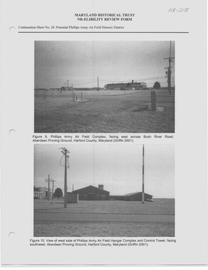
Area II Structure Assessment: Aberdeen Test Center's Foreign Vehicle Storage ATC's Foreign Vehicle Storage area is located east of the PAAF runways. Known originally as the Ordnance Quadrangle, the bomb assembly/loading plant within the complex currently serves as A TC's Foreign Vehicle Storage area. A secured area, the complex of buildings provides space to study and evaluate captured foreign combat vehicles (Figure 28).
Building 1080. On-site identification revealed that this was originally Building T3221, a wood frame guard station located at the gate behind Building 1089. Not listed in the Real Property inventory, the structure relocated into this area and stands abandoned. No photo is available.
Building 1081-Plant Utility. Building 1081 was constructed in 1943 as a distribution transmitter facility and was part of the Ordnance Quadrangle. The one and one-half story, side gable brick structure sits on a concrete foundation and has an asphalt shingle roof and wall vents, and a metal door (Figure 29).
Buildings 1082 through 1086 - High Explosive Magazines. These standard magazines were constructed for installation ammunition storage. The Quartermaster first issued the designs for powder magazines during the nineteenth century. These twentieth century magazines are built with a concrete and a central metal door and stored dynamite and other high explosives as well as fuses and detonators (Grandine and Cannan 1995: 125). Built in 1942, these magazines front what was then a bomb assembly plant (Building 1089). They have been abandoned and are scheduled for demolition. Each shed-like magazine is 65 square feet and constructed with concrete walls, foundation, and roof (Figure 30).
Building 1087 - High-Explosives Magazine Igloo. This earthfast igloo was constructed in 1943 and used for storing high-explosives bombs (Figure 31 ). During World War II, the concrete igloo was the most common ordnance storage structure constructed, especially at ordnance storage depots. The size of the igloo varied. While the width of the igloo remained constant at 26 feet, the length of the igloos ranged from 40, 60, to 80 feet (Grandine and Cannan 1995:127).
Building 1088 - Ready Igloo. Like Building 1087B, this earthfast igloo was built in 1942, and stored high explosives bombs. The igloo is 320 square feet and is constructed of concrete (Figure 32).
Building 1089 - Foreign Vehicle Maintenance Shed. Originally built as the bomb assembly plant in 1943, the structure was within the Ordnance Quadrangle, which served as a component within a support system to facilitate ordnance testing. Converted to space for studying captured foreign

MARYLAND IDSTORICAL TRUST NR-ELIBILITY REVIEW FORM
Continuation Sheet No. 10: Potential Phillips Anny Air Field Historic District
vehicles in 1981, the structure is constructed of brick on a concrete foundation and asphalt shingle roof. Not accessible, the interior of the structure has been modified to accommodate vehicles and tanks. Exterior modifications include loss of original windows, wall alterations with the installation of rolling overhead doors and an addition of a metal structure comparable in size abutting the original building on the east (Figure 33).
Building 1089A ·Support Building for Building 1089. Built in 1990 of corrugated metal, the structure has no windows and is accessible by an overhead garage door (Figure 34 ).
Building 1091 - Storage. Built in 1943 as the ordnance garage, it is currently a general-purpose warehouse. The structure is constructed of brick on a concrete foundation with an asbestos shingle roof (Figure 35). This building was being considered as a possible location for the ATEF office and control center after rehabilitation and expansion, which is still to be determined.
Building 1095 - Storehouse. Built in 1943 as a utility building, Building 1095 was constructed of galvanized sheet metal on a concrete foundation (Figure 36). It has been listed for demolition.
Building 1096 • Vehicle Maintenance Shop. Built in 1988, the structure continues to serve as a maintenance shop and is constructed of prefabricated metal (Figure 37).
Area Ill Structure Assessment: Aviation Arms Road Rail Spur This portion of the rail spur is maintained by ATC. The spur runs parallel with Aviation Arms Road past the Bomb Storage/Ammo Dump No. 2 (Buildings 712, 712A, 715, 718) and the Receiving Station and Storage area (Buildings 714A, 714D) to the Ammunition Loading and Receiving Depot (Building 714). No longer in service, the abandoned rail spur lies deteriorating, a rusted and twisted mass with missing sections of track no longer connected to the main rail system. The spur is listed for demolition. A 1946 area map depicts Aviation Arms Road and the rail line crossing over Airbase Loop Road, ending in a loading area north of Building 1081 (APG 1946b). The same map also details the rail spur forking on the west side of Airbase Loop Road at the intersection of Aviations Arms Road, which possibly allowed multiple cars into and out of the Ordnance Quadrant for loading and unloading (Figure 38). Current maps continue to show this area west of Airbase Loop Road, but no physical evidence remains of this portion of the spur.
Buildings along the spur include support structures needed to move and hold munitions for testing that are located along Aviations Arms Road east of PAAF.
Structure IV Structure Assessment: Bomb Storage/Ammo Dumps
Bomb Storage/Ammo Dump No. 2 A 1946 map depicts the area with an entrance road and two storage structures, with loading areas at either end of an east-west road within the area (APG 1946b ). The map also details a branch of rail spurring off the Aviation Arms Rail Spur into the bomb storage area, which is no longer extant. Fenced off, the area was inaccessible for photographs.
Building 712 - General Purpose Warehouse. Constructed in 1995 offabricated metal.

MARYLAND IDSTORICAL TRUST NR-ELIBILITY REVIEW FORM
Continuation Sheet No. 11: Potential Phillips Army Air Field Historic District
Building 715 - Ammo Hut. The ammo hut was constructed in 1986 of concrete block on a concrete foundation. The original building was destroyed in high winds and this replacement building was reconstructed on the same site.
Building 718 - Ammo Hut. Constructed in 1966 of corrugated aluminum, this building serves as a storage area for range residue.
Bomb Storage/Ammo Dump No. 3 Located across from the ATC Foreign Vehicle Storage on Airbase Loop Road, the area contains four loading aprons as depicted on a 1946 area map. Currently, there are no structures and the area is a fenced in gravel lot. No photo is available.
Area V Structure Assessment: Ammunition Shipping. Receiving and Magazine Loading Plant and Receiving Station and Storage
Building 714 - Ammunition Shipping, Receiving and Magazine Loading Plant. Originally a ready magazine, the plant is adjacent to the main rail line, which connected to the Aviations Arms Road rail spur running west toward the bomb loading area adjacent to PAAF and the Foreign Vehicle Storage area (Figure 39). It is associated to the receiving station (Building 714A). The six-bay warehouse is an elevated concrete structure, which currently accommodates the loading of supplies onto trucks for distribution.
Building 714A - Receiving Station. Located west of Building 714, the receiving station served as a loading dock area. Located on the Aviation Arms Road rail spur, the track leads directly to the bomb loading area adjacent to PAAF and the Foreign Vehicle Storage area. The open-air station is an elevated concrete ramp and platform covered by a metal shed roof supported by metal posts (Figure 40).
Building 714D - Storage Structure. Standing adjacent to the receiving station, no property record was found for this metal storage structure in the real property records.
Eligibility Determination of the Potential Phillips Army Air Field Historic District
Forty-two structures within five associated areas were assessed against the criteria established by the NRHP. The NRHP is the Nation's inventory of historic places that should be preserved. The criteria for evaluation are based on the quality of significance in American history, architecture, archaeology, engineering and culture. This significance is present in districts, sites, buildings, structures and objects that possess integrity of location, design, setting, materials, workmanship, feeling, and association, and:
A. That are associated with events that have made a significant contribution to the broad patterns of our history; or
B. That are associated with the lives of persons significant in our past; or
C. That embody the distinctive characteristics of a type, period, or method of construction, or that represent the work of a master, or that possess high artistic values, or that represent a significant and distinguishable entity whose components may lack individual distinction; or
, .

MARYLAND IDSTORICAL TRUST NR-ELIBILITY REVIEW FORM
Continuation Sheet No. 12: Potential Phillips Army Air Field Historic District
D. That have yielded, or may be likely to yield, information important in prehistory or history (DOI 1991).
To be eligible for the National Register, a property must be shown to have significance under at least one of these NRHP criteria and it must have integrity. "Integrity is the ability of a property to convey its significance" (DOI 1991 ). Although a property may meet the NRHP criteria, if it does not have integrity it cannot be eligible. Although determining integrity involves subjective judgment, this judgment is grounded in an understanding of the property's history, physical features, and the ways in which these features relate to its significance (DOI 1991 ). Integrity is determined by examining seven elements: location, design, setting, materials, workmanship, feeling, and association. To retain integrity, a property must possess several, and usually most, of theses aspects.
Buildings with ordinary uses, such as base operations buildings, and structures built according to standardized plans are unlikely to have significance or to meet NRHP criteria (Fort Worth USACE 1997).
Areas affected and surveyed for the proposed ATEF construction and potential historic district assessment included facilities historically associated with PAAF including structures and runways, the landscape of the University of Maryland's Fire Training Area, ATC's Foreign Vehicle Storage Area, and nearby structures located along the Aviation Arms Road rail spur.
Serving as a support facility for the exercise of testing munitions, the physical setting and structures at PAAF (Area I) were established as a means of achieving the installation's primary mission of testing and evaluation of weapons and weapon systems. Research and evaluation of PAAF revealed that the Air Field does not demonstrate criteria relevant to the history of aviation, the Cold War, or in the types of munitions flown and tested. Built from standardized plans, the Air Field displays the same design duplicated by the Army throughout the country in the 1930s and 1940s. Historically, PAAF served as a flying field, a necessary point of take-off and landing for planes carrying ordnance for dropping in the bombing fields to compile data to improve the adequacy of munitions. In PCl's opinion, PAAF is not significant as an historic district alone. A potential historic district would include PAAF, the Foreign Vehicle Storage area, Bomb Storage, Ammo Dumps No. 2 and 3, the Ammunition Shipping, Receiving and Magazine Loading Plant and Receiving Station and storage area, and the rail spur along Aviation Arms Road. Were the air field and surrounding complexes intact, they would be historically significant as a historic district under Criterion A, demonstrating interdependent activities of moving, assembling, storing, loading, and flying bombs for testing during World War II. In PCl's opinion, the historically associated complexes do not characterize an historic district due to the inability to physically convey the area's original functions and historical significance within APG's munitions testing mission.
Since World War II, activities within this area have physically altered the structures for changing missions, building tenants, and technological advancement in munitions and procedures to test materiel. PCI finds that the potential historic district is not eligible under any NRHP criteria due to the loss of structures and incompatible infill that destroy the area's historical setting, materials, feeling and association. Nor do the surrounding complexes once tied to the flying field individually retain the physical aspects necessary to convey the area's original task and process of assembling, loading and storing munitions for testing. It is PCl's opinion that the Air Field and the associated complexes lack integrity and are not eligible for listing in the NRHP as a historic district under Criteria A.
Although named for a pilot stationed at Aberdeen whom was the first killed during routine exercises at Aberdeen Proving Ground, research revealed no historically significant figures tied to any activity

MARYLAND IDSTORICAL TRUST NR-ELIBILITY REVIEW FORM
Continuation Sheet No. 13: Potential Phillips Anny Air Field Historic District
1 -
conducted within the survey area. Therefore, the Air Field and associated complexes do not meet the requirements defined by Criteria B.
Constructed in accordance with standardized plans, the air field does not demonstrate unique design methods and is one of many Army air fields with similar hangars, support buildings and runway configurations built during the 1930s and 1940s. The facility, a necessary utilitarian support element for testing munitions, served only as a pathway for take-off and landing of planes flown to explode ordnance. The loss of structures (Buildings 1047 and 1066) and the complex of structures on the air field's north axis (Buildings 1067-1078) render the complex incomplete. Infill of new structures (Buildings 1065 and 1068) changes the historical setting, association and feel of the air field. Loss of the air field's original control tower significantly alters the hangar's World War II design and signals the change in PAAF's mission. Standardization of plans and alterations render the Air Field not eligible under Criteria C. The Air Field is not of unique design and lacks integrity.
Lack of cultural resources found during the survey's archaeological investigation determined the Air Field as ineligible under Criteria D (Schieppati et al. 2002).
The structures located within the University of Maryland's Fire Training School, also within Area I, were built in 1995 and have no historical significance or association with PAAF outside of their location within the air field's original landscape. The Fire Training School is not eligible for listing in NRHP.
As a necessary support system to enable munitions testing the buildings within Area II, the Foreign Vehicle Storage area (the Ordnance Quadrangle) was built to standardized plans and does not meet the minimal requirements for listing in the NRHP as part of a historic district due to lack of integrity. The complex has lost original buildings by demolition (Buildings 1081, 1082-1086, 1095) and been in-filled with recent prefabricated metal buildings (Buildings 1089A, 1096), visually cluttering the complex. The main structure, the Bomb Assembly Plant (Building 1089) has been significantly altered to accommodate tanks and vehicles, with the loss of original windows, exterior walls for the installation of new overhead doors and an addition of a metal structure on the east side. No longer physically demonstrating the facility's original function, the alterations and modern infill undermine the area's integrity and disassociates the complex from the air field. The area is ineligible for listing in the NRHP under any criteria due to lack of integrity of historical design, setting, materials, feeling and association.
An adjacent rail spur, Area Ill, was directly associated to the separate complexes as a transportation corridor. The rail spur, running parallel with Aviation Arms Road east of PAAF, connected to the installation's main rail line east of Michaelsville Road. Originally servicing the Ordnance Quadrangle, the rail spur tied the separate areas together moving munitions from the Ammunition Plant to the Bomb Assembly Plant. No longer in service, the abandoned rail line lies deteriorated and rusted in a twisted mass, with missing sections of track no longer connected to the main rail system. In its current state, the isolated rail spur has lost all integrity and association to its original purpose of delivering munitions and is therefore, not eligible for inclusion in the NRHP. Under the jurisdiction of ATC, this section of rail is listed for demolition.
Investigation of the rail spur included assessment of adjacent structures along Aviation Arms Road to achieve context for the rail line. Buildings along the spur include structures that served as support structures needed to move and hold munitions for testing. Lack of association to their original purpose, alterations, loss of original buildings in both Bomb Storage/Ammo Dumps No. 2 and No. 3, and disassociation to the Bomb Assembly Plant without the rail spur renders Area IV not eligible for listing in the NRHP as it lacks historical association and original material. Without the rail spur, the Ammunition

MARYLAND IDSTORICAL TRUST NR-ELIBILITY REVIEW FORM
Continuation Sheet No. 14: Potential Phillips Army Air Field Historic District
Shipping, Receiving and Magazine Loading Depot and Receiving Station and storage areas (Area V) have become disassociated from their original functions within the process of moving munitions. Therefore, these areas do not meet the minimal requirements for listing in the NRHP.
Conclusion
Serving as a support facility for the testing of munitions, the physical setting and structures at PAAF were established as a means of achieving the installation's primary mission of testing and evaluation of weapons and weapon systems. Research and evaluation of PAAF revealed that the Air Field does not demonstrate significance according to criteria relevant to the history of aviation, the Cold War or in the types of munitions flown and tested. Built from standardized plans, the Air Field displays the same design duplicated by the Army throughout the country in the 1930s and 1940s. Historically, PAAF served as a flying field, a necessary point of take off and landing for planes carrying ordnance for dropping in the bombing fields to compile data to improve the munitions. In PCl's opinion, PAAF is not historically significant or does not meet criteria for listing in the NRHP as an historic district.
Research revealed a potential historic district of five associated areas adjacent to PAAF. Were the Air Field and surrounding complexes intact, they would be significant under Criterion A, demonstrating interdependent activities of moving, assembling, storing, loading, and flying bombs for testing during World War II. Disengaged from its once inter-connected process facilitating munitions testing, PAAF, the Foreign Vehicle Storage area (Ordnance Quadrangle), the rail spur, Bomb Storage/Ammo Dump Nos. 2 and 3, the ammunition plant, and the receiving station have become disassociated and no longer demonstrate their original functions. The areas lack integrity and physical appearance. The loss of the rail spur and original buildings, incompatible infill, alterations, changing missions and destruction by time and elements prevent the areas from representing their original and cohesive functions in the process of testing munitions during World War II. No longer able to convey historical purpose and significance, the Air Field and four adjacent complexes are ineligible for listing in the NRHP individually or collectively as a historic district. No Cold War-era significance was revealed during the survey or associated research for Phillips Army Air Field.
Based on the fieldwork, research and a National Register eligibility evaluation regarding the structures and activity surrounding the proposed test track, PCI determined that there are no historically significant areas or structures within the ATEF site, hence no buildings define or contribute to a Phillips Army Air Field historic district or historic landscape. Most landscapes near the proposed track are either part of an ever-changing environment (as the Bridge Testing Facility and Range 3), are moveable objects (airplanes and helicopters), or test ranges (such as the Aircraft Graveyard, Air Base 3, and Ammo Dump sites). In PCl's opinion, the construction of the ATEF will not affect the built environment or any cultural resources within or adjacent to the proposed site.
Prepared by:
Stacey L. Griffm Panamerican Consultants, Inc. 2390 Clinton Street Buffalo, NY 14227 716.821.1650 Date Prepared: _M_ar_c_h_2_00_2 ______ _

MARYLAND IDSTORICAL TRUST NR-ELIBILITY REVIEW FORM
Continuation Sheet No. 15: Potential Phillips Anny Air Field Historic District
BIBLIOGRAPHY
APG (Aberdeen Proving Ground) n.d. Real Property Files. Available Real Estate Office, Department of Public Works, Aberdeen
Proving Ground, Maryland.
1946a Drawing No. A.P.G. - 10633-13 WP, March 15, 1946. On file at the Public Works Office, Aberdeen area, Aberdeen Proving Ground, Maryland).
1946b Drawing No. A.P.G. -10633-15 WP, March 15, 1946. On file at the Public Works Office, Aberdeen area, Aberdeen Proving Ground, Maryland).
1986 General Site Map, Aberdeen Proving Ground, Sheet No. 4:4, September 1986. Map on file at the Public Works Office, Aberdeen Area, Aberdeen Proving Ground, Maryland.
2002 Aberdeen Proving Ground. (Online) Available http://www.apg.army.mil/his-mis/html April 10, 2002.
ATC (Aberdeen Test Center) 2000 ATC Visitor's Guide (Online) Available http://www.atc.army.mil/visitor/index.shtml, July 3,
2001.
2001a U.S. Army Aberdeen Test Center, Aberdeen Proving Ground, MD. (Online) Available http://www.atc.army.mil/index.shtml, July 3, 2001.
2001b Phillips Air Field. (Online) Available http://www.atc.army.mil/brochures/facilities/Phillips.shtml, July 3, 2001
Baltimore Sun (BS) 1941a "Shoe-Peg Corn Checks Army in Land Deal." 14 August, Baltimore, Maryland.
1941b "300 in Harford Must Seek Out New Homes." 24 September, Baltimore, Maryland.
Brown, Jerold E. 1990 Where Eagles Land: Planning and Development of U.S. Army Air Fields, 1910-1941.
Greenwood Press, New York.
DOI (Department of the Interior) 1991 How to Apply the National Register Criteria for Evaluation. National Register Bulletin 15.
U.S. Department of the Interior, National Park Service and lnteragency Resources Division, Washington DC.
Fort Worth USAGE (U.S. Army Corp of Engineers) 1997 Cold War Property Identification, Evaluation and Management Guidelines. U. S. Army
Corps of Engineers, Fort Worth, Texas.
GlobalSecurity 2002 Phillips Army Air Field (Online) Available
http://globalsecurity.org/military/facility/phillips. htm, March 5, 2002.

MARYLAND IDSTORICAL TRUST NR-ELIBILITY REVIEW FORM
Continuation Sheet No. 16: Potential Phillips Army Air Field Historic District
Grandine, Katherine 1998 Aberdeen Proving Ground Cod War Era Historic Context. Prepared for the Department of
the Army Baltimore District, Corps of Engineers by R. Christopher Goodwin & Associates, Inc., Frederick, Maryland.
Grandine, Katherine and Deborah Cannan 1995 Support and Utility Structures and Facilities (1917-1946): Overview, Inventory, and
Treatment Plan. Prepared for the Department of the Navy Atlantic Division, Naval Facilities Engineering Command by R. Christopher Goodwin & Associates, Inc., Frederick, Maryland.
Grandine, Katherine, Irene Jackson Henry and William R. Henry, Jr. 1982 DARCOM (United States Army Development and Readiness Command) Historic Building
Inventory Aberdeen Proving Ground Maryland. Prepared by National Park Service HABS/HAER.
Grandine, Katherine, Thomas W. Davis, Christopher R. Polglase, Kathryn M. Kurunda, Leo P. Hirrel, Tom Dod, Timothy Silva, S. Justine Woodward, Bethany M. Usher, and Geoffrey E. Mehuish
1996 Aberdeen Proving Ground Cultural Resource Management Plan. Final Report. Prepared for Atlantic Division, Naval Facilities Engineering Command, Norfolk, VA. R. Christopher Goodwin & Associates, Inc, Frederick, Maryland.
Harford Democrat (HD) 1967 Aberdeen Proving Ground 1917-1967. The Harford Democrat, Aberdeen, Maryland.
Keller, J. Timothy and Genevieve P. Keller 1995 How to evaluate and Nominate Designed Historic Landscapes. Prepared for the U. S.
Department of the Interior, National Park Service, Washington, DC. Land and Community Associates, Charlottesville, Virginia.
McClelland, Linda Flint, J. Timothy Keller, Genevieve P. Keller and Robert Z. Melnick 1990. Guidelines for Evaluating and Documenting Rural Historic Landscapes, National Register
Bulletin 30. National Park Service and Land and Community Associates for the U. S. Department of the Interior, National Park Service, Washington, DC.
Milbrooke, Anne with Patrick Andrus, Jody Cook and David B. Whipple 1998 National Register Bulletin Guidelines for Evaluating and Documenting Historic Aviation
Properties. U.S. Department of the Interior, National Park Service and the National Register of Historic Places, Washington, DC.
NARA (National Archives and Records Administration) n.d. Records of the Office of the Quartermaster General. RG 92. Construction Division
Completion Reports, Aberdeen Proving Grounds and Edgewood Arsenal, 1917-1945.
Pedrotty, Michael A., Julie L. Webster, Gordon L. Cohen, and Aaron R. Chmiel 1999 Historical and Architectural Overview of Military Aircraft Hangars: A General History,
Thematic Typology, and Inventory of Aircraft Hangars Constructed on Department of Defense Installations. Prepared for the United States Air Force Headquarters, Air Combat

MARYLAND IDSTORICAL TRUST NR-ELIBILITY REVIEW FORM
Continuation Sheet No. 17: Potential Phillips Army Air Field Historic District
/-, /..., ~
Command by the United States Army Construction Engineering Research Laboratory (CERL), Champaign, Illinois.
Schieppati, Frank J., Kelly Nolte, Stacey L. Griffin, Robert Hanley, and Christine M. Longiaru 2002 Cultural Resources Inventory and Evaluation for Proposed Automotive Technology
Evaluation Facility, and National Register Evaluation for Proposed Historic Districts, Phillips Army Air Field, Aberdeen Proving Ground, Harford County, Maryland. Prepared for the U. S. Army Medical Research and Materiel Command, Fort Detrick, Maryland. Panamerican Consultants, Inc., Buffalo, New York.
SOW (Statement of Work) 2000 Cultural Resources Inventory and Evaluation for Proposed Automotive Technology
Evaluation Facility and National Register Evaluation for Proposed Historic Districts Phillips Air Field, Harford County, MD. Aberdeen Proving Ground, Maryland.

MARYLAND IDSTORICAL TRUST NR-ELIBILITY REVIEW FORM
Continuation Sheet No. 18: Potential Phillips Army Air Field Historic District
FIGURES
Figure 1. Inventory of structures surveyed for a National Register evaluation of a potential Phillips Army Air Field Historic District, Aberdeen Proving Ground, Maryland.
Figure 2. Map of the buildings and structures in the potential Phillips Army Air Field Historic District survey boundaries.
Figure 3. Original layout of Phillips Army Air Field Complex as constructed in 1943, potential Phillips Army Air Field Historic District Area I.
Figure 4. Original layout of Ordnance Quadrangle as constructed in 1943, now ATC's Foreign Vehicle Storage area in the potential Phillips Army Air Field Historic District Area II.
Figure 5. Original (1943) layout of Aviation Arms Road rail spur running west from Ammunition Receiving Station & Shipping Building (Building 714), past the Receiving Station (Building 714A) and Bomb Storage/Dump No. 2, and across Airbase Loop Road. The spur ends in north yard of Ordnance Quadrangle, now the Foreign Vehicle Storage area.
Figure 6. Map of Aviation Arms Road rail spur in the potential Phillips Army Air Field Historic District Area Ill, running west from Michaelsville Road. The spur runs past the Ammunition Receiving Station & Shipping Buildings (Building 714) and the Receiving Station (Building 714A) in Area V, and ends north of the Foreign Vehicle Storage area.
Figure 7. Original (1946) layout of Bomb Storage/Ammo Dump No. 2 in the potential Phillips Army Air Field Historic District Area IV, and continuation of rail spur and Aviation Arms Road across Air Base Loop Road to the west.
Figure 8. Original (1946) layout of Bomb Storage/Ammo Dump No. 3, Potential Phillips Army Air Field Historic District Area IV.
Figure 9. V'tew of Phillips Army Air F'teld Hangar Complex, facing southeast.
Figure 10. View of west side of Phillips Army Air Field Hangar Complex and Control Tower, facing southwest.
Figure 11. Underground Water Reservoir (Building 1042) at Phillips Army Air Field, facing east.
Figure 12. Water Treatment Facility (Building 1043) at Phillips Army Air Field, facing north.
Figure 13. Abandoned Fuel Facility (Building 1047) at Phillips Army Air Field, facing east.
Figure 14. Fire Station/Aircraft Equipment Storage (Building 1059) at Phillips Army Air Field, facing south.
Figure 15. West elevation of Hangar (Building 1060) at Phillips Army Air Field, with original attached control tower, facing southeast, circa 1943.
Figure 16. West elevation of Hangar (Building 1060) at Phillips Army Air Field, facing east.
Figure 17. South elevation of Hangar (Building 1060) at Phillips Army Air Field, facing northeast.

MARYLAND IDSTORICAL TRUST NR-ELIBILITY REVIEW FORM
Continuation Sheet No. 19: Potential Phillips Army Air Field Historic District
\ l 'Y·- - .
Figure 18. Air Field Light Equipment Vault (Building 1061) at Phillips Army Air Field, facing east.
Figure 19. Plant Utility Building (Building 1062) at Phillips Army Air Field, facing south.
Figure 20. Electric Power/Oil Building (Building 1063) at Phillips Army Air Field, facing south.
Figure 21. Heating Plant (Building 1064) at Phillips Army Air Field, facing east.
Figure 22. Heating Plant Support Building (Building 1064A) at Phillips Army Air Field, facing southeast.
Figure 23. Aircraft Utility Supply Building and Garage (Building 1065) and Administration/General Purpose Building (Building 1068) at Phillips Army Air Field, facing southwest.
Figure 24. Inflammable Material Storehouse (Building 1066) at Phillips Army Air Field, facing north.
Figure 25. Flight Control Tower (Building 1067) at Phillips Army Air Field, facing west.
Figure 26. Flammable Material Storehouse (Building 1078) at Phillips Army Air Field, facing north.
Figure 27. View of Phillips Army Air Field and Taxiways from the Foreign Vehide Storage area, facing north.
Figure 28. View of Foreign Vehide Storage area from Phillips Army Air Field, facing south.
Figure 29. Plant utility Building (Building 1081) at Foreign Vehicle Storage area, facing north.
Figure 30. High Explosive Magazine (Building 1086) at Foreign Vehicle Storage area, facing north.
Figure 31. High Explosive Igloo (Building 1087) at Foreign Vehicle Storage area, facing northeast.
Figure 32. Ready Igloo (Building 1088) at Foreign Vehicle Storage area, facing northwest.
Figure 33. Foreign Vehicle Maintenance Shed (Building 1089, formerly the Bomb Assembly Plant), facing east.
Figure 34. Storage Building (Building 1089A) at Foreign Vehicle Storage area, facing west.
Figure 35. General Purpose Warehouse (Building 1091) at Foreign Vehicle Storage area, facing north.
Figure 36. Storehouse (Building 1095) at the Foreign Vehicle Storage area, facing east
Figure 37. Vehicle Maintenance Shed (Building 1096) at Foreign Vehicle Storage area, facing east.
Figure 38. Portion of Aviation Arms Road Rail Spur, facing west.
Figure 39. Ammunition Shipping/Receiving and Magazine Loading (Building 714), facing west.
Figure 40. Receiving Station Loading Dock (Building 714A) on Aviation Arms Rail Spur, facing east.

MARYLAND IDSTORICAL TRUST NR-ELIBILITY REVIEW FORM
Continuation Sheet No. 20: Potential Phillips Army Air Field Historic District
ISLDG T CAI<
AREA NO. BUil T ORIGINAL USE
PAAF 1°'42
PAAF 1°'43
PAAF 1°'47
PAAF 1059
PAAF 1060
PAAF 1061
PAAF 1062
PAAF 1063
PAAF 1064
PAAF 1064A
PAAF 1065
PAAF 1066
PAAF 1067
PAAF 1068
FTA 1074
FTA 1075
PAAF 1078
PAAF AIRFIELD
FVS 1080
FVS 1081
FVS 1082
FVS 1083
FVS
FVS
FVS
FVS
FVS
FVS
FVS
FVS
FVS
FVS
AD2
AD2
AD2
AD2
AD2
RS
RS
RS
ADJ
RR
1084
1085
1086
1087
1088
1089
1089A
1091
1095
1096
712
712A
715
718
714
714A
714D
RR
1943 U"GROUND WATER RESERV
1943 PUMPSTATION
1953 FUEL FACILITY
1943 FIRESTATION
1943 MAINT AIRCRAFT HANGAR
1943 ORDNANCE FACILITY
1943 EMERGENCY GENERATOR
1943 EMERGENCY GENERATOR
1943 BOILER HOUSE-TYPE B
1943 HEAT PLANT BUILDING
1942 ORDNANCE MAG/GARAGE
1942 READY MAGAZINE
1995 FLIGHT CONTROL TOWER
1995 ADMIN/GEN PURP
1995 ADMINICLASSROOM
1995 STORAGE
1943 FLAMM MAT STOREHOUSE
1943 RUNWAYS/TAXIWAYS
1943 GUARD STATION
1943 DIS TRANSFORMER
1942 HIGH EXPLOSIVE MAGAZINE
1942 HIGH EXPLOSIVE MAGAZINE
1942 HIGH EXPLOSIVE MAGAZINE
1942 HIGH EXPLOSIVE MAGAZINE
1942 HIGH EXPLOSIVE MAGAZINE
1943 HIGH EXPLOSIVE IGLOO
1942 READY IGLOO
1943 BOMB ASSEMBLY PLANT
1990 STORAGE
1943 ORDNANCE GARAGE
1943 UTILITY BLDG
1988 VEHICLE MAINTENANCE SHED
1943 BOMB STORAGE/AMMO DUMP
1995 STOREHOUSE
STOREHOUSE
1986 AMMO HUT
1966 AMMO HUT
1946 READY MAGAZINE
1943 RECEIVING/LOADING DOCK
STORAGE BUILDING
1943 STORAGE & DUMP AREA
1943 RAIL SPUR
CURRENT USE
UNDERGROUND WATER RESERVOIR
WATER SUPPORTfTREATMENT FAC
ABANDONED
AIRCRAFT EQUIPMENT STORAGE
MAINTENANCE AIRCRAFT HANGAR
LIGHT EQUIPMENT VAULT
PLANT UTILITY BUILDING
ELEC POWER/OIL BUILDING
HEATING PLANT
HEATING PLANT SUPPORT BUILDING
HAZ MAT CLEAN UP SUPPLY STORAGE
INFLAMMABLE MAT STOREHOUSE
FLIGHT CONTROL TOWER
ADMINIGEN PURP
ADMINICLASSROOM
STORAGE
FLAMMABLE MATERIAL STOREHOUSE
RUNWAYS/TAXIWAYS
ABANDONED
PLANT UTILITY
ABONDONED, LISTED FOR DEMOLITION
ABONDONED. LISTED FOR DEMOLITION
ABONDONED; LISTED FOR DEMOLITION
ABONOONED; LISTED FOR DEMOLITION
ABONDONED. LISTED FOR DEMOLITION
EARTHFAST IGLOO
EARTHFASTIGLOO
FOREIGN VEHICLE MAINT SHED
STORAGE
GENERAL-PURO STOREHOUSE
STOREHOUSE - LISTED FOR DEMO
VEHICLE MAINTENANCE SHED
STORAGE/DUMP FOR RANGE RESIDUE
GENERAL-PURP WAREHOUSE
GENERAL-PURP WAREHOUSE
AMMO HUT
RANGE RESIDUE STORAGE
AMMUNITIONS LOADING PLANT
ABANDONED
ABANDONED
OPEN AREA WITH LOADING APRONS
ABANDONED
PAAF: Ph1ll1ps Army Air Field FTA Fire Training Area
FVS: Foreign Vehicle Storage AD2 Ammo Dump No. 2
AD3: Ammo Dump 3 RS: Rece1v1ngtSh1pp1ng Station
SF MATERIALS
CONCRETE
822 CONCRETE
240 CONCRETE BLOCK
3,680 CONCRETE BLOCK
42,575 CORR TRANSITE
420 GALV SHEET METAL
420 GALV SHEET METAL
420 GALV SHEET METAL
796 CORR TRANSITE
CORR TRANSITE
11,111 BRICK
65 CONCRETE
3.115 METALPANEL
4,813 BRICK VENEER
CORRUGATED METAL
CORRUGATED METAL
2.031 BRICK
7999LF
20 WOOD
BRICK
65 CONCRETE
65 CONCRETE
65 CONCRETE
65 CONCRETE
65 CONCRETE
CONCRETE
320 CONCRETE
4.826 BRICK
PREFAB METAL
BRICK
GALV SHEET METAL
PREFAB METAL
FIELD WITH STRUCTURE~
CONCRETE BLOCK
CORR ALUMINUM
CONCRETE BLOCK
CONCRETE
METAL
GRAVEL LOT
II Bulldlng
No
No
No
No No No No
No
No
No
No
No
No
No
No
No
No No
No
No
No
No No
No
No
No
No
No
No No
No No
No
No
No
No No
No
No
No
No
No
Figure 1 . Inventory of structures surveyed for National Register Evaluation of the potential Phillips Army Air Field Historic District. Aberdeen Proving Ground, Harford County, Maryland.

MARYLAND HISTORICAL TRUST NR-ELIBILITY REVIEW FORM
r Continuation Sheet No. 21: Potential Phillips Army Air Field Historic District
AREAi AMMUNITION SHIPPING
ANO RECENING STATIONS
J
I
---a ATEF TRACK : POTENTIAL PAAF
HISTORIC DISTRICT BOUNDARIES
Figure 2. Map of the buildings and structures in the potential Phillips Army Air Field Historic District. Aberdeen Proving Ground, Harford County, Maryland (Griffin 2002).
PERRYMAN QUAD

MARYLAND IDSTORICAL TRUST NR-ELIBILITY REVIEW FORM
Continuation Sheet No. 22: Potential Phillips Army Air Field Historic District
AIR FIELD STRUCTURES
\NO LONGER
EXTANT
\ \
i I I I
1070-
I 1-----i I/ ;~---y---
~ i\ I \ I
I \ 1·
'\
BUSH RIVER ROAD --:...------
1\\--I \ /
\Y 1/'-\
\, '\,
1078 /
/ 1041----
Figure 3. Original layout of Phillips Army Air Field Complex as constructed in 1943, potential Phillips Army Air Field Historic District Area I. The map details structures originally constructed north of Bush River Road but no longer extant. Aberdeen Proving Ground, Harford County, Maryland (Drawing No. A.P.G.-10633-13 WP, March 15, 1946, courtesy of the Office of Public Works).

MARYLAND ffiSTORICAL TRUST NR-ELIBILITY REVIEW FORM
Continuation Sheet No. 23: Potential Phillips Army Air Field Historic District
1091 E:!:J
3
~. C1-129• 0 r~ PAAF LOADING
APRON
\
\
M-1089 ORIGINAL BOMB
ASSEMBLY PLANT
M-1088
M-1085 BOMB STORAGE
No.3
M-1087
Figure 4. Original layout of Ordnance Quadrangle as constructed in 1943, now ATC's Foreign Vehicle Storage area in the potential Phillips Army Air Field Historic District Area II. Aberdeen Proving Ground, Harford County, Maryland (Drawing No. A.P.G.-10633 - 15 WP, March 15, 1946 courtesy of the Office of Public Works).

MARYLAND IDSTORICAL TRUST NR-ELIBILITY REVIEW FORM
Continuation Sheet No. 24: Potential Phillips Army Air Field Historic District
Figure 5. Original layout of Aviation Arms Road rail spur running west from Ammunition Receiving Station & Shipping Building (Building 714), past the Receiving Station (Building 714A) and Bomb Storage/Dump No. 2, and across Airbase Loop Road. The spur ends in north yard of Ordnance Quadrangle, now the Foreign Vehicle Storage area. (General Site Map, Aberdeen Proving Ground, Sheet No. 4:4, September 1986, courtesy of the Office of Public Works.)

MARYLAND IDSTORICAL TRUST NR-ELIBILITY REVIEW FORM
Continuation Sheet No. 25: Potential Phillips Army Air Field Historic District
- --
I I
RANGE 8
-----
AREA Ill I j ' / I .
../
----!Qfo __
.i /'
/
.· ---/
',
\ -~~
I
I I
I \
'x---/ i
I \
/ ;.:-- .. ~~ .; ·-~~_:~ ..... ::
Figure 6. Map of Aviation Arms Road rail spur in the potential Phillips Army Air Field Historic District Area Ill, running west from Michaelsville Road. The spur runs past the Ammunition Receiving Station & Shipping Buildings (Building 714) and the Receiving Station (Building 714A) in Area V, and ends north of the Foreign Vehicle Storage area. Aberdeen Proving Ground, Harford County, Maryland (General Site Map, Aberdeen Proving Ground, Sheet No. 4:4, September 1986, courtesy of the Office of Public Works).

MARYLAND IDSTORICAL TRUST NR-ELIBILITY REVIEW FORM
Continuation Sheet No. 26: Potential Phillips Army Air Field Historic District
.. ..
BOMB STORAGE AREA No. 2
AIRBASE LOOP ROAD
\ ,\ I\ I ,
\
Figure 7. Original layout of Bomb Storage/Ammo Dump No. 2 in the potential Phillips Army Air Field Historic District Area IV, and continuation of rail spur and Aviation Arms Road across Air Base Loop Road to the west. Aberdeen Proving Ground, Harford County, Maryland (Drawing No. APG-10633-15 WP, March 15, 1946, courtesy of the Office of Public Works).

MARYLAND HISTORICAL TRUST NR-ELIBILITY REVIEW FORM
- Continuation Sheet No. 27: Potential Phillips Army Air Field Historic District
. SUB-SURFACE SAND FILTER
1093 ,/SEPTIC TANK
----++--+~------BOMB
M-1084
STORAGE/AM MO DUMP
M-1086
M-1087., ~
ATCFVSAREA . ~ § t::
,'. (, - . 1 -:·~ t •, I -_/_ - _,
Figure 8. Original layout of Bomb Storage/Ammo Dump No. 3, Potential Phillips Army Air Field Historic District Area IV. Aberdeen Proving Ground, Harford County, Maryland (Drawing No. APG-10633-15 WP, March 15, 1946, courtesy of the Office of Public Works).
MARYLAND IDSTORICAL TRUST NR-ELIBILITY REVIEW FORM
r Continuation Sheet No. 28: Potential Phillips Army Air Field Historic District
Figure 9. Phillips Army Air Field Complex, facing east across Bush River Road. Aberdeen Proving Ground, Harford County, Maryland (Griffin 2001 ).
Figure 10. View of west side of Phillips Army Air Field Hangar Complex and Control Tower, facing southwest. Aberdeen Proving Ground, Harford County, Maryland (Griffin 2001 ).

MARYLAND IDSTORICAL TRUST NR-ELIBILITY REVIEW FORM
I' Continuation Sheet No. 29: Potential Phillips Anny Air Field Historic District
Figure 11. Underground Water Reservoir (Building 1042) at Phillips Army Air Field, facing east. Aberdeen Proving Ground, Harford County, Maryland (Griffin 2001 ).
Figure 12. Water Treatment Facility (Building 1043) at Phillips Army Air Field, facing north. Aberdeen Proving Ground, Harford County, Maryland (Griffin 2001 ).

MARYLAND WSTORICAL TRUST NR-ELIBILITY REVIEW FORM
!""" Continuation Sheet No. 30: Potential Phillips Army Air Field Histonc District
Figure 13. Abandoned Fuel Facility (Building 1047), Phillips Army Air Field, facing east. Aberdeen Proving Ground, Harford County, Maryland (Griffin 2001 }.
Figure 14. Fire Station/Aircraft Equipment Storage (Building 1059), Phillips Army Air Field, facing south. Aberdeen Proving Ground, Harford County, Maryland (Griffin 2001 ).

MARYLAND msTORICAL TRUST NR-ELIBILITY REVIEW FORM
I"' Continuation Sheet No. 31: Potential Phillips Army Air Field Historic District
Figure 15. West elevation of Hangar (Building 1060) at Phillips Army Air Field with the original attached control tower circa 1943, facing southeast. Aberdeen Proving Ground, Harford County, Maryland (Courtesy of the Cultural Resource Manager's Office).
Figure 16. West elevation of Hangar (Building 1060) at Phillips Army Air Field, facing southeast. Aberdeen Proving Ground, Harford County, Maryland (Griffin 2001 ).

MARYLAND msTORICAL TRUST NR-ELIBILITY REVIEW FORM
Continuation Sheet No. 32: Potential Phillips Army Air Field Historic District
ll/J-cJ0.5!
Figure 17. South elevation of Hangar (Building 1060) at Phillips Army Air Field, facing northeast. Aberdeen Proving Ground, Harford County, Maryland (Griffin 2001 ).
Figure 18. Air Field Light Equipment Vault (Building 1061) at Phillips Army Air Field, facing east. Aberdeen Proving Ground, Harford County, Maryland (Griffin 2001 ).

MARYLAND mSTORJCAL TRUST NR-ELIBILITY REVIEW FORM
Continuation Sheet No. 33: Potential Phillips Army Air Field Historic District
Figure 19. Plant Utility Building (Building 1062) at Phillips Army Air Field, facing south. Aberdeen Proving Ground, Harford County, Maryland (Griffin 2001 ).
Figure 20. Electric Power/Oil Building (Building 1063) at Phillips Army Air Field, facing south. Aberdeen Proving Ground, Harford County, Maryland (Griffin 2001 ).

MARYLAND IDSTORICAL TRUST NR-ELIBILITY REVIEW FORM
,,,- Continuation Sheet No. 34: Potential Philhps Army Air Field Historic 01Strict
Figure 21. Heating Plant (Building 1064) at Phillips Army Air Field, facing east. Aberdeen Proving Ground, Harford County, Maryland (Griffin 2001 ).

MARYLAND HISTORICAL TRUST NR-ELIBILITY REVIEW FORM
Continuation Sheet No. 35: Potential Phillips Army Air Field Historic District
Figure 22. Heating Plant Support Building (Building 1064A) at Phillips Army Air Field, facing southeast. Aberdeen Proving Ground, Harford County, Maryland (Griffin 2001 ).
Figure 23. Aircraft Utility Supply Building and Garage (Building 1065) and Administration/General Purpose Building (Building 1068) at Phillips Army Air Field, facing southwest. Aberdeen Proving Ground, Harford County, Maryland (Griffin 2001 ).

MARYLAND IDSTORICAL TRUST NR-ELIBILITY REVIEW FORM
,,_. Continuation Sheet No. 36: Potential Phillips Anny Air Field Historic District
Figure 24. Inflammable Material Storehouse (Building 1066) at Phillips Army Air Field, facing north. Aberdeen Proving Ground, Harford County, Maryland (Griffin 2001).

MARYLAND WSTORICAL TRUST NR-ELIBILITY REVIEW FORM
,- Continuation Sheet No. 37: Potential Phillips Anny Air Field Historic District
Figure 25. Flight Control Tower (Building 1067) at Phillips Army Air Field, facing west. Aberdeen Proving Ground, Harford County, Maryland (Griffin 2001 ).

MARYLAND IDSTORICAL TRUST NR-ELIBILITY REVIEW FORM
r Continuation Sheet No. 38: Potential Phillips Anny Air Field Historic District
llA-d.o3?
Figure 26. Flammable Material Storehouse (Building 1078) at Phillips Army Air Field, facing north. Aberdeen Proving Ground, Harford County, Maryland (Griffin 2001 ).
Figure 27. View of Phillips Army Air Field and Taxiways from the Foreign Vehicle Storage area, facing north. Aberdeen Proving Ground, Harford County, Maryland (Griffin 2001 ).
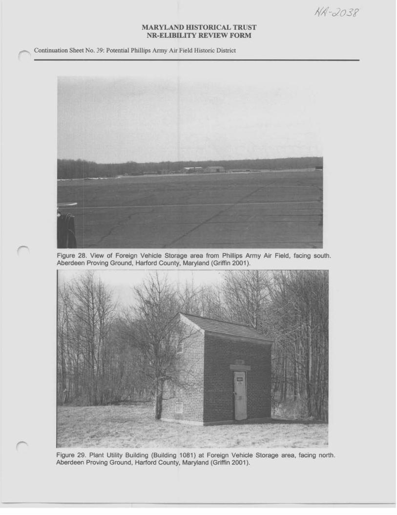
MARYLAND IDSTORICAL TRUST NR-ELIBU..,ITY REVIEW FORM
r"' Continuation Sheet No. 39: Potential Phillips Army Air Field Historic District
Figure 28. View of Foreign Vehicle Storage area from Phillips Army Air Field, facing south. Aberdeen Proving Ground, Harford County, Maryland (Griffin 2001 ).
Figure 29. Plant Utility Building (Building 1081) at Foreign Vehicle Storage area, facing north. Aberdeen Proving Ground, Harford County, Maryland (Griffin 2001 ).

MARYLAND msTORICAL TRUST NR-ELmaITY REVIEW FORM
Continuation Sheet No. 40: Potential Phillips Army Air Field Histonc District
Figure 30. High Explosive Magazine (Building 1086) at Foreign Vehicle Storage area, facing north. Aberdeen Proving Ground, Harford County, Maryland (Griffin 2001 ).
Figure 31. High Explosive Igloo (Building 1087) at Foreign Vehicle Storage area, facing northeast Aberdeen Proving Ground, Harford County, Maryland (Griffin 2001 ).

MARYLAND msTORICAL TRUST NR-ELIBJLITY REVIEW FORM
Continuation Sheet No. 41: Potential Phillips Army Air Field Historic District
Figure 32. Ready Igloo (Building 1088) at Foreign Vehicle Storage area, facing northwest. Aberdeen Proving Ground, Harford County, Maryland (Griffin 2001 ).
Figure 33. Foreign Vehicle Maintenance Shed (Building 1089), formerly the Bomb Assembly Plant, facing east. Aberdeen Proving Ground, Harford County, Maryland (Griffin 2001 ).

MARYLAND IDSTORICAL TRUST NR-ELIBILITY REVIEW FORM
Continuation Sheet No. 42: PotentiaJ Phillips Anny Air Field Historic District
llA1-c2o3f
I
Figure 34. Storage Building (Building 1089A) at the Foreign Vehicle Storage area, facing west. Aberdeen Proving Ground, Harford County, Maryland (Griffin 2001 ).
Figure 35. General Purpose Warehouse (Building 1091) at Foreign Vehicle Storage area, facing north. Aberdeen Proving Ground, Harford County, Maryland (Griffin 2001 ).

MARYLAND WSTORICAL TRUST NR-ELIBD.,ITY REVIEW FORM
- Continuation Sheet No. 43: Potential Phillips Army Air Field Historic District
fl/1-c/03f
Figure 36. Storehouse (Building 1095) at Foreign Vehicle Storage area, facing east. Aberdeen Proving Ground. Harford County, Maryland (Griffin 2001 ).
Figure 37. Vehicle Maintenance Shed (Building 1096) at Foreign Vehicle Storage area, facing east. Aberdeen Proving Ground, Harford County, Maryland (Griffin 2001 ).

MARYLAND WSTORICAL TRUST NR-ELIBILITY REVIEW FORM
Continuation Sheet No. 44: Potential Phillips Army Air Field Historic District
Figure 38. Portion of Aviation Arms Road Rail Spur, facing west. Aberdeen Proving Ground, Harford County, Maryland (Griffin 2001 ).
Figure 39. Ammunition Shipping/Receiving and Magazine Loading (Building 714), facing west. Aberdeen Proving Ground, Harford County, Maryland (Griffin 2001 ).
MARYLAND IDSTORICAL TRUST NR-ELIBILITY REVIEW FORM
~ Continuation Sheet No. 45: Potential Phillips Army Air Field Histonc Distnct
Figure 40. Receiving Station Loading Dock (Building 714A) on Aviation Arms Rail Spur, facing east. Aberdeen Proving Ground, Harford County, Maryland (Griffin 2001 ).