Embed Size (px)
Citation preview

METHODOLOGY GUIDE
VALUING FARMS IN ONTARIO
Valuation Date January 1 2016
AUGUST 2016
August 22 2016
The Municipal Property Assessment Corporation (MPAC) is responsible for accurately assessing
and classifying property in Ontario for the purposes of municipal and education taxes
In Ontariorsquos assessment system MPC assesses your property value every four years This year
MPAC is updating the value of every property in the province to reflect the legislated valuation
date of January 1 2016
MPAC is committed to provide Ontario property owners municipalities and all its stakeholders
with the best possible service through transparency predictability and accuracy in values As
part of this commitment MPAC has defined three levels of disclosure of information in support
of its delivery of this yearrsquos assessment update This Methodology Guide is the first level of
information disclosure
This guide provides an overview of the valuation methodology undertaken by MPAC when
assessing farm properties for this yearrsquos update ensuring the methodology for valuing these
properties is well documented and in alignment with industry standards
Property owners can access additional information about their own properties through
aboutmypropertyca Login information for aboutmypropertyca is provided on each Property
Assessment Notice mailed this year Additional information about MPAC can be accessed at
mpacca
Antoni Wisniowski Rose McLean MIMA
President and Chief Administrative Officer Chief Operating Officer
Table of Contents
10 INTRODUCTION 4
11 PROPERTIES COVERED BY THIS METHODOLOGY GUIDE 4
12 LEGISLATION 7
13 CLASSIFICATION 8
14 THE USE OF THIS METHODOLOGY GUIDE 9
15 CONSULTATION AND DISCLOSURE 9
16 MACHINERY AND EQUIPMENT 10
20 THE VALUATION PROCESS 11
21 OUTLINE 11
22 APPROACH 11
23 DATA COLLECTION 12
24 DATA ANALYSIS 12
25 VALUATION 14
26 VALIDATING THE RESULTS 15
30 THE VALUATION 16
31 THE COST APPROACH ndash MAIN STEPS 16
32 COST GUIDES 16
33 REPLACEMENT COST NEW 16
34 DEPRECIATION 17
35 IDENTIFYING DEPRECIATION DUE TO AGE OR CONDITION 17
36 IDENTIFYING FUNCTIONAL OBSOLESCENCE 18
37 IDENTIFYING EXTERNAL OBSOLESCENCE 18
38 QUANTIFYING DEPRECIATION 19
39 VALUING FARMLAND 19
312 EXAMPLE OF VALUATION OF FARM PROPERTY 28
313 CHECKING THE OUTCOME 29
314 CONCLUSION 29
10 Introduction
The Municipal Property Assessment Corporation (MPAC) ndash mpacca ndash is responsible for
accurately assessing and classifying property in Ontario for the purposes of municipal and
education taxation
In Ontario property assessments are updated on the basis of a four-year assessment cycle In
2016 MPC will update the assessments of Ontariorsquos nearly five million properties to reflect
the legislated valuation date of January 1 2016 Assessments updated for the 2016 base year
are in effect for the 2017ndash2020 property tax years
The last Assessment Update was based on a January 1 2012 valuation date Increases between
the 2012 assessed value and 2016 assessed value are phased in over a four-year period Any
decreases in assessment are applied immediately
It is important to ensure that the valuation methodology applied is capable of providing a
realistic estimate of current value at the relevant valuation date which in turn enables all
stakeholders to understand the valuation process and have confidence in the fairness and
consistency of its outcome
This Methodology Guide has been prepared for the benefit of MPAC assessors property
owners and their representatives municipalities and their representatives Assessment Review
Board members provincial officials and the general public
This guide outlines the valuation process to be followed by an assessor including steps that
require appraisal judgment It is incumbent upon the assessor to make informed decisions
throughout the valuation process when arriving at estimates in current value
11 Properties Covered by This Methodology Guide
Farm properties vary widely in size and agricultural production There are a variety of
components that need to be considered when determining the value of a farm property These
include the value of the farmland the value of the farm outbuildings the value of the
residence as well as any other non-farm structures that may exist
MPAC treats land used for primary agricultural productionoperation as farmland Primary
agricultural productionoperation is the raising or production of primary agricultural
commodities on a commercial basis and includes
copy Municipal Property Assessment Corporation 2016 All rights reserved 4
field crops
livestock raising breeding and grazing (ie cattle swine)
poultry rearing hatchery
dairy farming
fruit orchards and vineyards
maple syrup producing properties (subject to criteria set out in Ontario Regulation 28604)
board and maintenance of horses (subject to criteria set out in Ontario Regulation 10005)
horticulture including sod nursery stock and Christmas trees
fish farming including licenced ponds that are used to propagateculture and sell bass and trout
fur farming
bee keeping
MPAC does not value the following uses of a property as a farm
the retailing of goods or services
storage of primary agricultural commodities for others as a business operation
maintenance of livestock or other animals for recreational purposes
manufacturing of primary agricultural commodities
the breeding and raising of pets
The following MPAC property codes are used to categorize the various types of farms in
Ontario
200 Farm property without any buildingsstructures
201 Farm with residence ndash with or without secondary structures no farm outbuildings
210 Farm without residence ndash with secondary structures with farm outbuildings
copy Municipal Property Assessment Corporation 2016 All rights reserved 5
211 Farm with residence ndash with or without secondary structures with farm outbuildings
220 Farm without residence ndash with commercialindustrial operation
221 Farm with residence ndash with commercialindustrial operation
222 Farm with a winery
223 Grainseed and feed operation
224 Tobacco farm
225 Ginseng farm
226 Exotic farms (ie emu ostrich pheasant bison elk deer)
227 Nut orchard
228 Farm with gravel pit
229 Farm with campgroundmobile home park
230 Intensive farm operation ndash without residence
231 Intensive farm operation ndash with residence
232 Large scale greenhouse operation
233 Large scale swine operation
234 Large scale poultry operation
235 Government (agriculture research facility ndash predominately farm property)
260 Vacant residentialcommercialindustrial land (owned by a non-farmer with a portion being farmed)
261 Land owned by a non-farmer improved with a non-farm residence with a portion being farmed
262 Land owned by a farmer improved with a non-farm residence with a portion being farmed
copy Municipal Property Assessment Corporation 2016 All rights reserved 6
It should be noted that these are general guidelines that vary depending on the specific
circumstances of a particular property
An assessor may also make reference to additional Methodology Guides for properties that do
not fall precisely within the description of one of the property codes listed above
12 Legislation
The main legislation governing the assessment of properties in Ontario for property tax
purposes is contained in the Assessment Act1
The Act contains important definitions and states what property is taxable and how it should be
valued Section 19(1) of the Act requires that land be assessed at current value which is
defined to mean in relation to land ldquothe amount of money the fee simple if unencumbered
would realize if sold at arms length by a willing seller to a willing buyerrdquo
To establish the current value of farm properties Section 19(5) of the Assessment Act states
that ldquoFor the purpose of establishing value of farm lands used only for farm purposes and the
buildings thereon used solely for farm purposes including the residence on the farm lands
consideration shall be given to the current value of the lands and buildings for farming
purposes only and in determining the current value consideration shall not be given to sales of
lands and buildings to persons whose principle occupation is other than farmingrdquo This means
properties that are used for farm purposes are assessed based on their current use not any
potential use to which the property could be put such as development land The lands to which
Section 19(5) applies is set out in Section 44 and Section 441 of Ontario Regulation 28298
Under Section 3(1)19 of the Assessment Act one acre of every ten acres of farmed property
may be entitled to receive a Farm Forestry Exemption (FFE) FFE is warranted if the property is
assessed as a farm and the property has some forested or woodland portion that is not subject
to either the Managed Forest Tax Incentive Program (MFTIP) or the Conservation Land Tax
Incentive Program (CLTIP)
In addition legislation governs the classification of farm properties for property tax purposes
The Minister of Finance filed Ontario Regulation 43015 on December 18 2015 which added
additional rules affecting the valuation and classification of properties on which a third-party
sign (billboard) is located To comply with the regulation the income attributable to a third-
party sign will not be included in the valuation of any property for assessment purposes
1 Assessment Act RSO 1990 c A31 httpswwwontariocalawsstatute90a31
copy Municipal Property Assessment Corporation 2016 All rights reserved 7
13 Classification
MPCrsquos role is to accurately assess and classify all properties in Ontario in accordance with the
Assessment Act and its associated regulations established by the Government of Ontario The
classification of a property will determine which tax rate will be applied by the municipality or
taxing authority All properties are classified according to their use and Ontario Regulation
28298 sets out how various property uses are classified
Farm properties are classified in the Residential Property Class in accordance with Section 3(1)2
of Ontario Regulation 28298 of the Assessment Act which includes ldquofarm land to which
subsection 19(5) of the Act applies for the taxation year for which the land is being classified
other than land in the farm property class or land prescribed under section 44rdquo2
If the owner of the property meets the criteria for the Farm Property Class as administered by
the Ontario Ministry of Agriculture Food and Rural Affairs (OMAFRA) the farmland and farm
outbuildings are taxed at 0 to 25 of the municipal residential tax rate If the property is
farmed but does not meet the criteria of the Farm Property Class (FT) the property would be
valued as a farm by MPAC (under Section 195) but would be placed in the Residential Property
Class (RT) An application for inclusion in the Farm Property Class Tax Rate Program must be
approved by OMAFRA on or before the specific date set out in the table included in Section 81
of Ontario Regulation 28298
If a portion(s) of a farm property is used for non-farm purposes the portion is valued and
classified according to its use This is to ensure that the appropriate value and tax class is
applied to the various uses of the property
Where there is a farm residence occupied by the farmer this is assessed in the Residential
Property Class along with one acre of land valued at the farmland rate Where there is a
residence on a farm property that is occupied by a non-farmer this is assessed in the
Residential Property Class along with one acre of land valued at the residential rate The
separate assessment of the farm residence is necessary as the residential tax rate applies to the
portion of the property that is used for residential purposes
2 Ontario Regulation 28298 GENERAL httpswwwontariocalawsregulation980282
copy Municipal Property Assessment Corporation 2016 All rights reserved 8
14 The Use of This Methodology Guide
This Methodology Guide is intended to
Ensure MPCrsquos assessed values for these properties are fair accurate predictable and
transparent
Provide direction to assessors and clear explanations to municipalities taxpayers and
Assessment Review Board members
Ensure that MPCrsquos methodology for valuing these properties is well documented and
aligns with industry standards
Explain the thought processdecision-making process that an assessor should undertake
to apply the valuation methodology
Ensure a consistent approach to valuing these property types
Support MPAC assessors in conducting their due diligence in
applying Ontariorsquos legislation and regulations
adhering to industry standards for market valuation in a mass appraisal
environment
It should be noted that this Methodology Guide is not intended to be a substitute for an
assessorrsquos judgment in arriving at a market valuendashbased assessment (ie current value) for a
particular property However given that the Methodology Guide explains industry standards
for property assessment conforms to valuation industry norms and adheres to provincial
legislation and regulation MPAC assessors are expected to follow the procedures in the
Methodology Guide and be able to clearly and satisfactorily justify any deviations from it
15 Consultation and Disclosure
MPAC is committed to providing municipalities taxpayers and all its stakeholders with the best
possible service through transparency predictability and accuracy In support of this
commitment MPAC has defined three levels of disclosure as part of its delivery of the 2016
province-wide Assessment Update
Level 1 ndash Methodology Guides explaining how MPAC approached the valuation of
particular types of property
copy Municipal Property Assessment Corporation 2016 All rights reserved 9
Level 2 ndash Market Valuation Reports explaining how the methodology outlined in Level 1
has been applied at the sector level for the purposes of each assessment
Level 3 ndash Property Specific Valuation Information available to property taxpayers their
representatives and municipalities
16 Machinery and Equipment
Farm properties may contain machinery and equipment that is used for farming purposes
Under Section 3(1) 17 of the Assessment Act all machinery or equipment used for farming
purposes and the foundations upon which they rest are exempt from taxation
copy Municipal Property Assessment Corporation 2016 All rights reserved 10
20 The V aluation Process
The valuation process begins with a determination that the current use of the subject property
is farming
Any reliance upon this guide is made only after the assessor has determined that the current
use of the subject property is that of a farm
Assessors determine the value of a property using one of three different approaches to value
the direct (sales) comparison approach
the income approach
the cost approach
21 Outline
In the direct (sales) comparison approach value is indicated by recent sales of comparable
properties in the market In considering any sales evidence it is critical to ensure that the
property sold has a similar or identical highest and best use as the property to be valued
In the income approach (or more accurately the income capitalization approach) value is
indicated by a propertyrsquos revenue-earning power based on the capitalization of income This
method requires a detailed analysis of both income and expenditure both for the property
being valued and other similar properties that may have been sold in order to ascertain the
anticipated revenue and expenses along with the relevant capitalization rate
In the cost approach value is estimated as the current cost of reproducing or replacing
improvements of the land (including buildings structures and other taxable components) less
any loss in value resulting from depreciation The market value of the land is then added
MPAC uses the cost approach to value farm properties This valuation method is widely
recognized by experts in the appraisal profession
22 Approach
There are three main phases in the process used by MPAC
data collection
analysis of the data collected
valuation
copy Municipal Property Assessment Corporation 2016 All rights reserved 11
23 Data Collection
The data required for farm property valuations comes from a number of sources
bull land title documents
bull building permits
bull on-site property inspections and communications with property owners
bull review of sales transactions
Data collection may also include an inspection to obtain physical and descriptive information
about the location size and use of the property the quality of the land in terms of type and
depth of soil topography stoniness drainage susceptibility to flooding andor erosion etc
the age and type of the residence if there is one the extent of any farm outbuildings and their
uses
MPAC staff may also discuss with the farmer the detail of the farming operations carried out on
the property to obtain accurate information about its use and agricultural capability
MPAC continually collects and updates detailed information for every property in Ontario to
ensure that similar property types are valued consistently within the market area
24 Data Analysis
The market value of land used for farming purposes must reflect its current use as agricultural
land To establish the value of farmland in its current use MPAC analyses sales of vacant
farmland purchased by farmers
After the 2012 Assessment Update the Ministry of Finance made recommendations to MPAC
as part of the Special Purpose Business Property Assessment Review (SPBPAR) Two of the
recommendations pertained to farm properties
Improve the sales verification process by ensuring that analysis of farm sales reflects
only sales of farmland to a farmer
Strengthen the accuracy and equity of the valuation process by ensuring that an
adequate sample size is used for farm sales analysis such as having regard for a larger
geographic area and expanding the sales analysis period
copy Municipal Property Assessment Corporation 2016 All rights reserved 12
To address the concerns that have been expressed about the accuracy of the assessment of
farmland MPAC has implemented both of these recommendations for the 2016 CVA
MPAC in consultation with municipal and industry stakeholders developed an enhanced sales
verification and analysis process for the 2016 Assessment Update This enhanced sales
verification process ensured that only sales of farmland to farmers are used in the analysis As
part of this process a mandatory review of all vacant farmland sales of 10 acres or more was
completed A standard letter and farm sales questionnaire is sent to all new owners of farmland
each month MPAC reviews the farm sales questionnaires and conducts follow-up phone calls
andor property inspections to obtain more detailed information as required
To strengthen the accuracy and equity of the farm valuation process and to ensure an adequate
sample size of farm sales were used in the analysis for the 2016 CVA MPAC made the following
adjustments to its process
increased the sales period to 8 years (it was previously 5 years)
included sales of properties 10 acres or larger (it was previously 20 acres or larger)
included sales of properties with minimal outbuilding value (less than 25)
Including the sales of smaller parcels of farmland and farmland with minimal outbuildings
assists with developing land rates for organic soils Properties with minimal outbuildings sell
very similarly to vacant farmland These changes increased the number of farm sales reviewed
by 39 and allowed MPAC to gain greater market evidence
In addition to ensure equity of the farmland valuation process MPAC undertook a
comprehensive review of farm neighbourhoods This review included refining boundaries and
examining where combination or expansion of farm geographic neighbourhoods needed to
occur Combining farm neighbourhoods provided MPAC with more market transactions to
analyze in determining land rates in specific geographic areas As part of this process MPAC
also reviewed fringe and bordering areas to ensure equity of farm neighbourhoods between
geographic regions
copy Municipal Property Assessment Corporation 2016 All rights reserved 13
25 Valuation
The key elements of a farms assessment are provided below
Farmland
The farmland is assessed according to its agriculture capability (ie its ability to produce crops
andor maintain livestock) Farmland is classified into six different quality classes with Class 1
farmland having the highest agricultural capability and therefore the most valuable type of
farmland All farms in Ontario are assigned to a farm neighbourhood for establishing a current
value Farm neighbourhoods capture differences in location and seek to take into account
common factors such as climatic region soil type and suitability and similar properties selling
for similar prices per acre Within each farm neighbourhood adjustments are made to reflect
different soil quality classification
Residence
The value of the residential structure is determined by establishing a replacement cost of the
building less any depreciation This approach takes into account the age size type and quality
of the residence
Residence Site
If the farm residence is occupied by the person farming the property one-acre of farmland is
typically attributed to the residence for classification purposes and is valued at the highest class
of farmland rate present on the property The farm residence and the one acre of farmland are
classified in the Residential Tax Class providing they are used solely for residential purposes
If the residence is occupied by someone other than the person farming the property it is
treated as a non-farm residence and any land associated with the residence not being farmed is
valued at residential land values The non-farm residence and any land associated with it is
classified in the Residential Tax Class provided they are used solely for residential purposes
Farm Outbuildings
A farm outbuilding is any improvement other than a residence that is used for farming
operations (eg a barn silo grain bin etc) Farm outbuildings are valued on the depreciated
replacement cost approach taking into account their design age size quality of construction
etc
copy Municipal Property Assessment Corporation 2016 All rights reserved 14
Other Buildings
All other buildings (eg a retail store) not used in the farm operation are valued on the
depreciated replacement cost approach taking into account their use design age size quality
of construction etc Other buildings are classified according to their use (ie residential
commercial industrial etc)
26 Validating the Results
In validating the assessment it is necessary to carry out a series of checks to ensure that all
relevant parts of the property have been included in the valuation The next part of the process
is to compare the valuation with market evidence available in relation to similar properties
copy Municipal Property Assessment Corporation 2016 All rights reserved 15
30 The Valuation
31 The Cost Approach ndash Main Steps
The cost approach derives a value by estimating the cost to replace the functionality and utility
of a property in this case a farm property In broad terms this requires three main steps
1) Establish the costs as new to construct the improvements
2) Deduct all forms of depreciation ndash the difference between the cost as new and the
market value of the improvements (ie the amount the improvements would sell for as
of the valuation date)
3) Add the current value of the land to the depreciated value of the improvements
32 Cost Guides
MPAC uses various cost guides to value all structures on farm properties Residential structures are
valued using the 1980 provincial cost manual indexed to the legislated valuation date Farm
structures are valued using the MPAC Agricultural Cost Guide and commercial and industrial
structures are valued using commercial and industrial cost rates The use of cost guides
standardized physical depreciation tables and adjustments for other forms of depreciation ensures
that a consistent approach is used by MPAC when valuing all structures on farm properties
All cost guides contain data that reflects the cost of labour equipment and materials for each
structural element of an improvement
33 Replacement Cost New
Replacement cost new is the current cost of a similar new asset that has the nearest equivalent
utility as the asset being valued
Using existing records andor carrying out an inspection of a property to collect physical and
descriptive data about the existing land and buildings (ie age size use etc) MPAC is in a
position to carry out the costing exercise
MPAC uses its various cost guides to determine the replacement cost of all buildings and
structures on farm properties
Having determined the replacement cost new of the property by applying the cost guides to the
actual improvements (ie buildings structures etc) or their modern equivalent the next step
is to consider any adjustments to replacement cost new to reflect depreciation
copy Municipal Property Assessment Corporation 2016 All rights reserved 16
34 Depreciation
The difference between the cost of a new building (or other improvement) and the amount the
market would pay for the improvements is the depreciation inherent in the building
Depreciation can be quite complex and making adjustments to replacement cost requires
knowledge analysis and judgment to accurately reflect depreciation
There are three classes of depreciation to consider
physical (resulting from wear and tear due to use and exposure to the elements)
functional obsolescence (resulting from some defect in the existing property)
external obsolescence (resulting from adverse factors outside the property)
Both physical and functional depreciation can be sub-divided into two types
curable (cost effective to fix)
incurable (cannot be fixed or cannot be fixed cost effectively)
All elements of depreciation affect the value of a property Depreciation can be quantified in a
number of ways but in order to help with the quantification process it is important to identify
all forms of depreciation present from the onset
35 Identifying Depreciation Due to Age o r Condition
All properties suffer physical decline as they age The amount of depreciation applied depends
on three factors
the expected useful life assigned to the building or structure
the quality of the construction
whether any variance to the effective age has been identified
Age-related depreciation is generally applied on the basis of the effective age of a building or
structure A brand new building has very little depreciation (if any) whereas a building or other
improvement approaching the end of its useful life has a significant amount of depreciation
copy Municipal Property Assessment Corporation 2016 All rights reserved 17
Most buildings would be assigned a typical expected useful life based on construction style
However there are some uses that tend to shorten the life of a property due to greater
physical wear and tear
A determination of effective age is completed by an evaluation of the physical state and condition
of the improvements If the condition of the improvements is typical for the age of the structure
then no adjustments are required If the improvements are worse than typical then an age
variance can be applied Assigning an older effective age increases the depreciation If the
improvements have recently been upgraded or renovated then the effective age can be
decreased This lowers the amount of age-related depreciation applied by the cost system
Consideration also needs to be given to whether any repairs may be necessary or whether
there is any deferred maintenance that may impact the value of the existing buildings or other
improvements When accounting for deferred maintenance the assessor must ensure that the
loss in value is not already being accounted for as age-related depreciation
36 Identifying Functional Obsolescence
Functional obsolescence relates to some defect in the existing buildings or structures that make
them less valuable than a modern equivalent
There are two main forms of functional obsolescence
The building size construction andor height are overbuilt for current requirements
Other elements of the property make it less efficient to operate than more modern farm
properties (eg design or layout)
37 Identifying External Obsolescence
External obsolescence is a loss in value that results from factors that are external to the
property itself and outside the control of the property owner
Farm properties may experience external obsolescence as a result of changes in feed costs
commodity prices or diseases which impact the agricultural industry as a whole or within a
specific segment External obsolescence may impact the value of agricultural buildings on a
farm property
copy Municipal Property Assessment Corporation 2016 All rights reserved 18
38 Quantifying Depreciation
Physical deterioration and some elements of functional obsolescence may be taken into
account by the use of a replacement cost that assumes a modern farm building is replacing the
existing property
However the valuation relates to the actual property so adjustments still need to be made in
the valuation to reflect such factors as defects outstanding repairs and deferred maintenance
As is often the case the detailed information needed to calculate the impact of functional
obsolescence may not be readily available In these situations the functional obsolescence may
be recognized by a qualitative adjustment made by MPCrsquos assessor as to the impact it is likely
to have on the current value of the property This type of deduction can be applied as a
percentage deduction on a component-by-component basis or by a property-wide deduction
In terms of external obsolescence MPAC analyzed microeconomic and macroeconomic forces
that would impact each sectorrsquos economic viability for farm buildings across Ontario
Having made all appropriate adjustments to the replacement cost for depreciation and
obsolescence the resulting value will be an estimate of the contribution of the improvements
to the current value of the subject property
39 Valuing Farmland
Farmland values are based on the landrsquos agricultural capability and other factors such as location
The value of a farm is not based on other potential uses for the land (eg development) In
determining farmland rates only sales of land to be used for farm purposes are analyzed
Farmland Neighbourhoods
A farmland neighbourhood may be defined by natural man-made or political boundaries and
may be reviewed and updated as changes impact an area
Each farm property in Ontario is assigned a farmland neighbourhood for the purposes of
establishing a value These geographic areas capture differences in location and attempt to
address commonalities such as
climatic zones or regions
soil quality
similarities in market value
similarities in farm operations
copy Municipal Property Assessment Corporation 2016 All rights reserved 19
Soil parcels are groupings of acreages of farmland with similar characteristics Factors that
affect agricultural capability are the most critical element to be considered when valuing
farmland By identifying soil parcels on the farm that have similar characteristics we can assign
an associated soil classification based on agricultural capability Each class of soil on the farm is
then valued according to its respective capability
Soil Classification
The land is assigned to different classifications based on factors that measure the agricultural
capability of the soil
MPAC uses a Land Classification Point System as a guide for valuing farmlands based on its
agricultural capability MPCrsquos soil pointing process allocates and deducts points from 100 in
increments of 5 the upper limit is 95 and the lower limit is 5 The points are determined using
the following seven factors that affect mineral soils soil texture topography stoniness
drainage flooding erosion depth to bedrock
Soil Texture
Texture refers to the amount of sand silt and clay in the soil MPAC uses five texture
classifications Soil texture is a major influence on the type of crops grown as well as on crop
yield and varies considerably across Ontario
Characteristic Description Points
Loam Silt Loam This soil has approximately equal amounts of sand silt and clay
Silt Loam feels somewhat gritty but is fairly smooth and slightly
plastic when wet
0
Sandy Loam This soil is predominantly sand with some silt and clay It feels
gritty but is not as loose as sand
5
Clay Loam This soil contains enough clay to be sticky It is often lumpy
when dry
5
Clay This soil contains a high proportion of small soil particles (clay)
It feels smooth and is sticky and plastic when moist and hard
and cloudy when dry
10ndash15
Sand This soil contains a high proportion of the largest soil particles
(sand) It is usually porous and open It has a coarse gritty feel
10ndash20
copy Municipal Property Assessment Corporation 2016 All rights reserved 20
Topography
Topography refers to the lay of the land Five topography classifications are used
Characteristic Description Points
Level This land has 0ndash2 slope (ie the slope is 2 feet or less per 100
feet of horizontal distance) Land is flat or nearly flat
0
Gently Sloping This land has 3ndash6 slope The erosion hazard is greater than
level land
5
Rolling This land has considerable slope 7ndash12 and usually has some
irregularity A moderate erosion hazard exists It presents no
serious handicap to farm machinery
10
Hilly This land has 13ndash20 slope A moderately severe erosion
hazard exists Farm machinery can be used but with difficulty
15ndash25
Steep This land has 21ndash30 slope It is susceptible to severe erosion
and is not suited for extensive use of farm machinery
30ndash65
The steeper the slope the harder it is for farm equipment to access the lands for crops and the
harder it is for livestock to access the land for grazing therefore the greater the slope the
greater the point deduction for soil classification
Stoniness
Stoniness refers to the amount of stones in the soil profile Three stoniness classifications are
used
Characteristic Description Points
Stone Free This land has little or no stone in the soil 0
Moderate Stone This land has sufficient stone to interfere with the cultivation of
some crops and the use of certain machinery but can be used
for regular rotation
5ndash15
Very Stony This land has too much stone to allow cultivation but is suitable
for use as pasture
20ndash40
copy Municipal Property Assessment Corporation 2016 All rights reserved 21
Drainage
Drainage refers to the ease of movement of water and air in the soil or to the height of the
water table Four drainage classifications are used
Characteristic Description Points
Good Good drainage is determined when soil layers are well defined
uniform and bright reddish or yellowish brown Movement of
air and water through the soil is not restricted ldquoFairrdquo or ldquoPoorrdquo
drainage soils may be included in this class if they have been
effectively tile drained
0
Fair Fair drainage is determined when the surface soil is darker than
in well-drained soil Underlying layers are dull yellowish brown
mottled or blotched with reddish brown They are not as well
defined as well-drained soils although they do provide fairly
favourable conditions of air and water movement
5
Rapid Rapid drainage usually occurs on sand or gravel soils with no
finer texture overburden Horizon colours are bright and
uniform It sometimes occurs on soils on steep slopes
5ndash15
Poor Poor drainage is determined when the surface soil is very dark
and the underlying layers are dull grey with reddish-brown
blotches Water and air movement through the soil is
restricted
20ndash40
In instances where certain crops are best suited to sandy or sandy loam soils points should not
be deducted automatically for rapid drainage (ie ginseng peanuts and tobacco)
Flooding
Flooding refers to the periodic flooding of land by an overflow from streams or rivers
CharacteristicsDescription Points
No Flooding 0
Flooding 10ndash30
copy Municipal Property Assessment Corporation 2016 All rights reserved 22
Erosion
Erosion refers to the loss of soil by water and wind Three classifications are used
Characteristic Description Points
None No surface soil removed No noticeable erosion takes place 0
Moderate Most of surface soil removed Some subsoil (B horizon)
material is present in the cultivated layer
10
Severe All of the surface soil has been removed Subsoil material (C
horizon) predominates in the cultivated layer
20
Depth to Bedrock
Depth to bedrock refers to the depth of the soil over the underlying bedrock Where this
distance is very small (ie less than one foot) the soil is often susceptible to erosion and may
lack topsoil
Characteristic Description Points
Deep Over 3rsquo 0
Moderate 2rsquo to 3rsquo 20
Shallow 3rdquo to 1rsquo6rdquo 30ndash65
Once all the factors are considered the points are deducted and the final ldquoscorerdquo is used to
determine the soil class
General descriptions of soil classes are listed below It is important to remember soil classes can
change region to region and municipality to municipality Class 1 in one municipality can be
different than Class 1 in another municipality
Soil Quality
The two types of soil found throughout Ontario are mineral and organic soils
copy Municipal Property Assessment Corporation 2016 All rights reserved 23
Mineral Soil Classification
Mineral soil is the inorganic layer of earth composed of sand silt and clay in varying amounts
with less than 20 organic matter in the surface layer It is the most predominant soil type
found throughout Ontario
Mineral farmland is classified according to the following variables topography soil texture
stoniness drainage flooding erosion and depth to bedrock
There are six classes of mineral farmland
Mineral Soil Class Description Points
1 This land has good drainage good loam texture and is nearly
level No physical limitations to a high level of farm production
exist
95ndash85
2 This land is subject to moderate limitations in use for farm crop
production These limitations may be drainage rolling
topography moderate erosion moderate stoniness or a
combination of two or more factors
80ndash70
3 Similar limitations to those of Class 2 above only to a greater
extent This land has moderately severe limitations that restrict
the range of crops or may require some development or
management practices
65ndash55
4 This land is subject to severe limitations for use in farm crop
production such as too susceptible to erosion too stony or too
poorly drained to be cultivated frequently
50ndash40
5 This land is generally unsuited to cultivation but can be used
for grazing It is subject to similar but more severe limitations
than those of Class 4
35ndash25
6 This land should be kept in vegetation because of steepness of
slope severe erosion shallow soil or other features that make
cultivation impractical This land is capable of producing only
indigenous crops and is suitable for moderate grazing
0ndash20
copy Municipal Property Assessment Corporation 2016 All rights reserved 24
Organic Soil Classification
Organic soil is developed from plant residues that have been preserved by the presence of a
high water table (commonly called peat or muck) As with mineral soils organic soils are
classified using a similar pointing system These points are allocated in an increment of 5 which
are deducted from 100 The upper limit for soil classification points is 95 the lower limit is 5
There are five factors that are used in the classification of organic soils
decomposition
reaction
woody layers
depth
substratum texture
Decomposition
There are 3 stages of decomposition
Characteristic Description Points
Humic The most highly decomposed of the soil types It has a rubbed
fibre content of less than 10 of the organic volume
0
Mesic In the intermediate stage of decomposition It has rubbed fibre
content between 10 and 40 of the organic volume
20
Fibric The least decomposed of all organic soil materials There are
large amounts of well-preserved fibre that are readily
identifiable as to botanical origin A rubbed fibre content of
more than 40 of the organic volume exists
35
Reaction
Reaction refers to the acidity or alkalinity of the soil as expressed by a PH factor The PH factor
for Southern Ontario is generally between 50 and 70
copy Municipal Property Assessment Corporation 2016 All rights reserved 25
Characteristic Points
PH between 50 and 70 0
PH under 50 20
PH over 70 20
Woody Layers
Wood located within 20 inches of the surface will probably interfere with cultivation of the
land Wood content is expressed as a percentage of the organic volume
Characteristic Points
None 0
1 to 25 of organic volume 5
26 to 50 of organic volume 10
More than 50 of organic volume 20
Depth
Depth refers to the depth of organic material over sand silt loam clay marl or bedrock
Limitations occur when any of these materials occur within six feet of the surface
Characteristic Description Points
Deep More than 72rdquo 0
Moderately Deep 52rdquo to 72rdquo 20
Shallow 36rdquo to 52rdquo 35
Very Shallow Less than 36rdquo 50
copy Municipal Property Assessment Corporation 2016 All rights reserved 26
Substratum Texture
Substratum texture refers to the granular texture of the subsoil It may be composed of sand
silt loam clay marl or bedrock Points are deducted if the granulation is medium or coarse
Characteristic Points
Fine 0
Medium or Coarse 20
Organic Farmland
There are six classes of organic farmland
Organic Soil Class Description Points
1 This land has no water topographical or PH limitations and is
deep and level These soils are at an intermediate stage of
decomposition
95ndash85
2 This land has one limitation that restricts its use in a minor way
The limitation may be woodiness extreme acidity or alkalinity
expressed by a PH factor flooding topography depth or
climate
80ndash70
3 This land has moderate to severe limitations that restrict the
variety of crops or require special development and
management practices such as crop rotation and fertilization
65ndash55
4 This land has severe limitations that restrict the variety of crops
or require special development and management practices
such as crop rotation and fertilization
50ndash40
5 This land has such severe limitations that it is restricted to the
production of perennial forage or other specially adapted crops
35ndash25
6 This land is capable of only producing indigenous crops
Improvement practices are not feasible
0ndash20
copy Municipal Property Assessment Corporation 2016 All rights reserved 27
Within each farm neighbourhood adjustments are determined for each soil classification Soil
classifications quantify the factors that contribute to the agricultural capability of the soil
In order to determine the current value of a farm property only open market armrsquos length
sales of farmland to farmers are used Farms sold for non-agricultural potential use (ie
development) are not considered for this purpose
All farmland sales are analysed from across the province using Computer Assisted Mass
Appraisal (CAMA) techniques
By definition CAMA is the valuation of a group of properties as of a common date using
standardized methods common data and statistical testing The results of the mass appraisal
analysis are often in the form of valuation equations and parameters (mass appraisal models)
applied to individual property data in order to establish an estimate of current farmland value
for all farmland across Ontario
MPAC uses a statistical tool known as multiple regression analysis (MRA) to apply the direct
comparison approach to value Mass appraisal is used to develop the valuation parameters
which explain the value influences in order to estimate the current value of farmland from real
estate data compiled by MPAC
The mass appraisal model will typically allocate value based on a propertyrsquos agricultural
capability size and location (ie farmland neighbourhood)
The value of land for non-agricultural purposes is determined using an analysis associated with
the non-agricultural use For example a residential land portion will be derived from an analysis
of residential sales
The value of all land is then added to the depreciated replacement cost of the buildings or
other improvements to arrive at the current value of the property See example below
312 Example o f Valuation of Farm Property
The following provides a simplified outline of what the valuation may look like for a farm
property located in Southwestern Ontario
100-acre farm property with a mix of Class 1 3 and 6 farmland
farm residence
two farm outbuildings
copy Municipal Property Assessment Corporation 2016 All rights reserved 28
Estimated replacement cost new of residence $250000
Estimated depreciation of residence ndash$85000
Depreciated value of residence $165000
Estimated replacement cost new of farm outbuildings
$300000
Estimated depreciation and obsolescence of farm outbuildings
ndash$120000
Depreciated value of farm outbuildings $180000
100 acres of farmland
50 acres of class 1 land at $15575 per acre $778750
30 acres of class 3 land at $10875 per acre $326250
20 acres of class 6 land at $2475 per acre $49500
Estimated land value $1154500
Total farm property value $1499500
313 Checking the Outcome
Having completed the valuation using the cost approach MPCrsquos assessor will review the
outcome to ensure that it is an accurate assessment of the current value of the property and is
in line with the assessment of other similar farm properties
314 Conclusion
This guide sets out how MPAC assessors approach the valuation of farms for property
assessment purposes
Although it outlines the general approach adopted it does not replace the assessorrsquos judgment
and there may be some cases where the assessor adopts a different approach for justifiable
reasons
For further information about MPCrsquos role please visit mpacca
copy Municipal Property Assessment Corporation 2016 All rights reserved 29
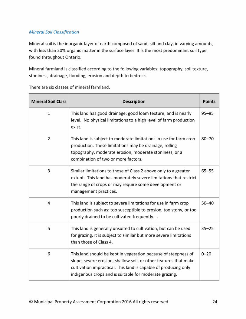

Characteristic Points
PH between 50 and 70 0
PH under 50 20
PH over 70 20
Woody Layers
Wood located within 20 inches of the surface will probably interfere with cultivation of the
land Wood content is expressed as a percentage of the organic volume
Characteristic Points
None 0
1 to 25 of organic volume 5
26 to 50 of organic volume 10
More than 50 of organic volume 20
Depth
Depth refers to the depth of organic material over sand silt loam clay marl or bedrock
Limitations occur when any of these materials occur within six feet of the surface
Characteristic Description Points
Deep More than 72rdquo 0
Moderately Deep 52rdquo to 72rdquo 20
Shallow 36rdquo to 52rdquo 35
Very Shallow Less than 36rdquo 50
copy Municipal Property Assessment Corporation 2016 All rights reserved 26
Substratum Texture
Substratum texture refers to the granular texture of the subsoil It may be composed of sand
silt loam clay marl or bedrock Points are deducted if the granulation is medium or coarse
Characteristic Points
Fine 0
Medium or Coarse 20
Organic Farmland
There are six classes of organic farmland
Organic Soil Class Description Points
1 This land has no water topographical or PH limitations and is
deep and level These soils are at an intermediate stage of
decomposition
95ndash85
2 This land has one limitation that restricts its use in a minor way
The limitation may be woodiness extreme acidity or alkalinity
expressed by a PH factor flooding topography depth or
climate
80ndash70
3 This land has moderate to severe limitations that restrict the
variety of crops or require special development and
management practices such as crop rotation and fertilization
65ndash55
4 This land has severe limitations that restrict the variety of crops
or require special development and management practices
such as crop rotation and fertilization
50ndash40
5 This land has such severe limitations that it is restricted to the
production of perennial forage or other specially adapted crops
35ndash25
6 This land is capable of only producing indigenous crops
Improvement practices are not feasible
0ndash20
copy Municipal Property Assessment Corporation 2016 All rights reserved 27
Within each farm neighbourhood adjustments are determined for each soil classification Soil
classifications quantify the factors that contribute to the agricultural capability of the soil
In order to determine the current value of a farm property only open market armrsquos length
sales of farmland to farmers are used Farms sold for non-agricultural potential use (ie
development) are not considered for this purpose
All farmland sales are analysed from across the province using Computer Assisted Mass
Appraisal (CAMA) techniques
By definition CAMA is the valuation of a group of properties as of a common date using
standardized methods common data and statistical testing The results of the mass appraisal
analysis are often in the form of valuation equations and parameters (mass appraisal models)
applied to individual property data in order to establish an estimate of current farmland value
for all farmland across Ontario
MPAC uses a statistical tool known as multiple regression analysis (MRA) to apply the direct
comparison approach to value Mass appraisal is used to develop the valuation parameters
which explain the value influences in order to estimate the current value of farmland from real
estate data compiled by MPAC
The mass appraisal model will typically allocate value based on a propertyrsquos agricultural
capability size and location (ie farmland neighbourhood)
The value of land for non-agricultural purposes is determined using an analysis associated with
the non-agricultural use For example a residential land portion will be derived from an analysis
of residential sales
The value of all land is then added to the depreciated replacement cost of the buildings or
other improvements to arrive at the current value of the property See example below
312 Example o f Valuation of Farm Property
The following provides a simplified outline of what the valuation may look like for a farm
property located in Southwestern Ontario
100-acre farm property with a mix of Class 1 3 and 6 farmland
farm residence
two farm outbuildings
copy Municipal Property Assessment Corporation 2016 All rights reserved 28
Estimated replacement cost new of residence $250000
Estimated depreciation of residence ndash$85000
Depreciated value of residence $165000
Estimated replacement cost new of farm outbuildings
$300000
Estimated depreciation and obsolescence of farm outbuildings
ndash$120000
Depreciated value of farm outbuildings $180000
100 acres of farmland
50 acres of class 1 land at $15575 per acre $778750
30 acres of class 3 land at $10875 per acre $326250
20 acres of class 6 land at $2475 per acre $49500
Estimated land value $1154500
Total farm property value $1499500
313 Checking the Outcome
Having completed the valuation using the cost approach MPCrsquos assessor will review the
outcome to ensure that it is an accurate assessment of the current value of the property and is
in line with the assessment of other similar farm properties
314 Conclusion
This guide sets out how MPAC assessors approach the valuation of farms for property
assessment purposes
Although it outlines the general approach adopted it does not replace the assessorrsquos judgment
and there may be some cases where the assessor adopts a different approach for justifiable
reasons
For further information about MPCrsquos role please visit mpacca
copy Municipal Property Assessment Corporation 2016 All rights reserved 29