Embed Size (px)
Citation preview
Integrated Flood Risk Analysisand Management Methodologies
Methodology for Decision Support Systems forFlood Event Management
Date February 2007
Report Number T19-07-02Revision Number 1_0_Pn
Task Leader WL | Delft Hydraulics
FLOODsite is co-funded by the European CommunitySixth Framework Programme for European Research and Technological Development (2002-2006)
FLOODsite is an Integrated Project in the Global Change and Eco-systems Sub-PriorityStart date March 2004, duration 5 Years
Document Dissemination LevelPU Public PUPP Restricted to other programme participants (including the Commission Services)RE Restricted to a group specified by the consortium (including the Commission Services)CO Confidential, only for members of the consortium (including the Commission Services)
Co-ordinator: HR Wallingford, UKProject Contract No: GOCE-CT-2004-505420Project website: www.floodsite.net


FLOODsite Project ReportContract No:GOCE-CT-2004-505420
FLOODsite Project Report Task 19 DSS Methods_v2 21 01 2007iii
DOCUMENT INFORMATION
Title Methodology for Decision Support Systems for Flood EventManagement
Lead Author Marnix van der VatContributors Marc Erlich, Darren Lumbroso and Marjolein MensDistribution [Click here and list Distribution]Document Reference [Click here and enter Document Reference]
DOCUMENT HISTORY
Date Revision Prepared by Organisation Approved by Notes01/02/07 1_0_Pn Marnix van
der VatWL | DelftHydraulics
ACKNOWLEDGEMENT
The work described in this publication was supported by the European Community’s Sixth FrameworkProgramme through the grant to the budget of the Integrated Project FLOODsite, Contract GOCE-CT-2004-505420.
DISCLAIMER
This document reflects only the authors’ views and not those of the European Community. This workmay rely on data from sources external to the FLOODsite project Consortium. Members of theConsortium do not accept liability for loss or damage suffered by any third party as a result of errorsor inaccuracies in such data. The information in this document is provided “as is” and no guarantee orwarranty is given that the information is fit for any particular purpose. The user thereof uses theinformation at its sole risk and neither the European Community nor any member of the FLOODsiteConsortium is liable for any use that may be made of the information.
© FLOODsite Consortium

FLOODsite Project ReportContract No:GOCE-CT-2004-505420
FLOODsite Project Report Task 19 DSS Methods_v2 21 01 2007iv
SUMMARY
This report describes the methodology for Decision Support Systems for Flood Event Management.An overall approach is presented. For three pilot areas this general approach is applied to specific partsof flood event management. The pilot areas are the Thames (UK), Schelde (NL) and urban flash floodsin France. For each of the pilots the design of a prototype Decision Support System is described.

FLOODsite Project ReportContract No:GOCE-CT-2004-505420
FLOODsite Project Report Task 19 DSS Methods_v2 21 01 2007v

FLOODsite Project ReportContract No:GOCE-CT-2004-505420
FLOODsite Project Report Task 19 DSS Methods_v2 21 01 2007vii
CONTENTS
Document Information iiiDocument History iiiAcknowledgement iiiDisclaimer iiiSummary ivContents vii
1. Introduction..................................................................................................................11.1 Objectives ........................................................................................................11.2 Approach .........................................................................................................11.3 Overview of the report .....................................................................................11.4 Links with other tasks.......................................................................................11.5 Lessons learned from previous projects ............................................................1
2. DSS methodology ........................................................................................................32.1 Methodological framework ..............................................................................32.2 Flood Event Management tasks and their application........................................62.3 Risk based decision support..............................................................................7
3. DSS Design..................................................................................................................83.1 Thames ............................................................................................................83.2 Schelde ............................................................................................................83.3 Urban flash floods .......................................................................................... 16
4. References ................................................................................................................. 17

FLOODsite Project ReportContract No:GOCE-CT-2004-505420
FLOODsite Project Report Task 19 DSS Methods_v2 21 01 2007viii

FLOODsite Project ReportContract No:GOCE-CT-2004-505420
FLOODsite Project Report Task 19 DSS Methods_v2 21 01 20071
1. Introduction1.1 ObjectivesThe objective of task 19 of the FLOODsite programme is to link knowledge and models fromFLOODsite themes 1 and 2 in a Decision Support System (DSS) in support of emergencymanagement planning and practice. The DSS aims to provide the relevant authorities with support indeciding on the evacuation procedure to follow. The EU Flood Directive will make the preparation forflood event management imperative. Efforts within the FLOODsite programme to develop decisionsupport can help the relevant authorities with the implementation of the Flood Directive.
1.2 ApproachAs a first step, a review has been made of existing DSSs for flood event management within the EU(Maaten et al, 2007). The main conclusion of this report is that there is not a lot of experience withusing DSSs for flood event management, as opposed to the much wider experience of using DSSs forlong term flood risk management. In the same report, an assessment of the requirements of the end-users is presented. The end-users have been identified as the authorities responsible for flood eventmanagement. For evacuation this is mostly the municipal or provincial authority. Specialisedinstitutions play an important role as well, such as the Environment Agency in the United Kingdomand regional water authorities in the Netherlands. The main user requirements focus on availability ofinformation regarding the extent of flooding expected, the consequences for the transport network andthe time required for evacuation.
1.3 Overview of the reportThis report presents the next step towards the development of DSSs for flood event management.Chapter 2 presents a methodological framework for flood event management DSSs. Thiscomprehensive framework is used to develop the design of prototype DSSs for pilot studies, asdescribed in Chapter 3. These prototype DSSs will be implemented and presented to the end-users.These results will be presented in the final report of FLOODsite task 19. The lessons learned from thedesign, implementation, application and presentation of the prototype DSSs will be delivered toTheme 5 of FLOODsite to be included in the best practice guidelines for flood risk analysis andmanagement and related training activities.
1.4 Links with other tasksA clear link exists with FLOODsite task 18, which focuses on the development of a DSS for long-termflood risk management. The review of existing DSSs and the formulation of a methodology have beendeveloped in close cooperation with task 18. However, due to the different tasks of the DSSs to bedeveloped, no overlap is expected in de the development of prototype applications of the DSSs.
The DSS for flood event management links knowledge from different tasks within FLOODsite theme1 and 2, such as:
Modelling breach initiation and growth (task 6);Reliability analysis of flood defence structures and systems (task 7);Flood inundation modelling / methodologies (task 8);Real-time guidance for flash-flood risk management (task 16); andEmergency flood management - evacuation planning (task 17).
1.5 Lessons learned from previous projectsOSIRIS (Operational Solutions for the management of Inundation Risks in the Information Society)was originally a 5th EU FP project under the IST (Information Society Technology) programme(Erlich, 2006). Its goal consisted in improvement of the dissemination, using Information andCommunication Technologies (ITC), of information on flood risk to citizens for better prevention orcrisis management. In the framework of OSIRIS a prototype of a tool called “OSIRIS-Inondation” hasbeen developed to provide operational solutions to local managers of the Loire River basin. The main

FLOODsite Project ReportContract No:GOCE-CT-2004-505420
FLOODsite Project Report Task 19 DSS Methods_v2 21 01 20072
objective consisted in provision of a tool, which can help the local stakeholders to make use of theofficial forecasts and to link them to other documents: flood prevention plans, rescue organisationplans, which since French law of 2004 become a part of a regulatory document called CommunitySafeguard Plan (PCS). The “OSIRIS-Inondation” prototype was specified, tested and validated by thedifferent groups of stakeholders represented by an active OSIRIS partner and committed end-userEtablissement Public Loire (EPLoire).
An important part of the work consisted in the validation of the demonstrators, which was carried onas part of the OSIRIS project activities. It consisted in confirmation (or information) that the prepareddemonstrators do indeed reflect the needs and expectations of users, as articulated during the designphase. As part of this appraisal, the content of the individual tools was revised, and improvements tothe software were identified as well as improvements to the user interface, suggested by thestakeholders responsible for the testing off the software.
Tests of the usefulness and suitability of the demonstrators being built in the project were conductedwith many appraisal groups associated with flood damage mitigation, as well as with inhabitants atrisk for flooding. This latter group, as well as local- and county-level crisis managers, was the mostfrequently used appraisal group. Practically all partners responsible for building and testing ofdemonstrators conducted appraisals with these groups.
For the two demonstrators being built in France, test participants also included representatives of:technical municipal and department services, elected representatives and local government institutions(EP Loire) or institutions responsible for flood safety (DIREN).
As a consequence of the positive feedback received from different stakeholders in the Loire Riverbasin the French authorities decided to pursue a validated approach and the Centre d’EtudesTechnique Maritime et Fluvial (CETMEF), a service of the French Ministry of Infrastructure, is nowin charge of the further development of OSIRIS-Inundation and of its distribution. Detailedinformation is available at the following address: http://www.ist-osiris.org/indexOsiris.html.
The OSIRIS experience (both during the project and the post-project industrialisation phase of the“OSIRIS-inondation”) was integrated in the Tasks 17 (Asselman et al, 2007) and 19 (Maaten et al,2007). The results of the OSIRIS project formed a major input for the assessment of the users’requirements and the review of flood event management decision support.
In Task 19 , the principal benefit lies in integration in the DSS design phase the appropriate sources ofinformation related to prevention plans.
FLOODsite Project ReportContract No:GOCE-CT-2004-505420
FLOODsite Project Report Task 19 DSS Methods_v2 21 01 20073
2. DSS methodology2.1 Methodological frameworkThe methodological approach is based on terminology presented in the FLOODsite report Languageof Risk (Gouldby et al, 2004). The aim is to support relevant authorities in flood event management.This support can be during the preparation for flood event management or during the actual floodevent. The support should lead to risk based decision making based on a comparison of the riskresulting from different management options. Management options in flood event management can bedivided into four categories:
Operational flood prevention;Operational flood management;Evacuation; andRescue.
Operational flood prevention consists of flood prevention measures that can be taken in the timebetween the forecast of a flood event and the actual event. Examples of these measures are operationof barriers and retention areas and the temporary raising of dikes with sand bags. Long term floodprevention measures, such as lowering of the floodplain are not incorporated.
In the case of operational flood management the aim is not to prevent the flooding event itself, but toinfluence the way the flooding proceeds. This can be done by, for example, opening or closing sluicegates that influence the flooding pattern.
A very important management option in flood event management is decision whether or not toevacuate. Evacuation deals with the relocation of humans, livestock and capital goods from an areathreatened by flooding to a safe place. During the preparation phase evacuation plans should beprepared to enable evacuation during a flood event.
Management options in rescue determine the amount of resources used for rescue and the way they aredeployed. An important question to be solved in flash flood areas is the state of the transport networkto be used by rescue services.
Flood event management starts with a forecast of a flood event provided by a flood early warningsystem.
The scheme below presents the methodological framework for flood event management DSSs. Theframework consists of several modules. The external driver module describes the existing situationprior to the flood and the boundary conditions for the flood event. The tools module consists of thetools used in the other modules. The management response module describes the management optionsavailable to the decision maker. The analysis is described in the modules in the central column.

FLOODsite Project ReportContract No:GOCE-CT-2004-505420
FLOODsite Project Report Task 19 DSS Methods_v2 21 01 20074
Figure 1: Methodological framework
Exposure module
Vulnerability module
Hazard module
Risk module
Provision of Information to Decision Makers
Fluvial / tidal water levels at different locationsBreach locations and growth
Flood characteristics (depth, velocity, extent)
Inhabitants (spatial distribution, age, shelter)Livestock (spatial distribution, shelter)
Property and utilities (spatial distribution, shelter)Actual capacity of transport network (under flood conditions)
Expected damage for a forecasted water level summed over the different breach locationsexpressed in euros or number of people
Consequence module
Damage to inhabitants (affected people, exposed people, casualties)Damage to livestock, property and utilities (expressed in the value lost)
Relation between flood characteristics and damage (value lost, people injured, casualties)for individual objects in the different categories
Management responsemodule
Operational floodprevention (sand bags,
retention areas,temporary barriers,
storm surge barriers)Operational flood
management ( closureof gates)
Evacuation, rescueand warning
Tools moduleExternal drivermodule
DischargeWater levelPrecipitationWindTideTopographyDrainage system
Data on people andlivestockTime of the day of theexpected flood eventProperty and utilities atrisk and part of this thatis moveableTransport network
Flood Early WarningSystemsReliability analysisof flood defencesystemHydrodynamicmodel
Reference damagefunctions
Damage and casualtiesmodel
Evacuation model
FLOODsite Project ReportContract No:GOCE-CT-2004-505420
FLOODsite Project Report Task 19 DSS Methods_v2 21 01 20075

FLOODsite Project ReportContract No:GOCE-CT-2004-505420
FLOODsite Project Report Task 19 DSS Methods_v2 21 01 20076
The boundary conditions of the flood event are forecast fluvial / tidal water levels that will come froma flood forecasting system. This forms the input of the hazard module. Based on an analysis of thereliability of the flood defence system, the most likely locations of failure of the defence system areselected. For each location a failure probability is established. For dikes, a breach growth model canbe applied to describe the growth of the breach over time and its final dimensions. The information onwater level and breach location and growth can be combined in a hydrodynamic inundation model tocalculate the flood characteristics for each possible failure location. At the level of the hazard module,the decision maker can influence the flood characteristics by operational flood prevention measuresand operational flood management measures, as described in section 2.1.
The exposure module compares the information on the flood characteristics with static information onthe distribution of the receptors such as inhabitants, livestock, property, utilities and the transportnetwork. This defines the exposure to the flood event. The exposure can be influenced by execution ofan evacuation or by a rescue operation.
The vulnerability module defines the relation between flood characteristics and damage. This relationis different for different types of humans and goods, depending on their characteristics (such as age)and their shelter (such as the type of building they are in). The input to the vulnerability moduleconsists of reference damage functions established theoretically or empirically based on flood damagedata or for example loss of life or injury functions for people exposed to floodwaters.
In the consequence module a damage and casualties model combines the exposure and thevulnerability and calculates the damage to inhabitants, livestock, property and utilities. Damage toinhabitants can be expressed as number of people affected, exposed or injured and the number ofcasualties to be expected. Damage to livestock property and utilities is expressed as value lost. Thedamage calculation is executed for each possible breach location. If the accumulated effect ofcombined breaches can be expected to differ from the sum of the effects, calculations for thecombined situation should be carried out as well. If management options such as evacuation have beenselected, their influence will be incorporated through the resulting effect in the exposure.
The risk module combines the results of the consequence module for the different breach locations.Combination takes place by summation for each location the probability of failure times the resultingdamage. The combined risk is expressed as the expected damage of a forecast flood event under theselected management option. Again damage can be expressed as value lost, number of people affected,exposed or injured and the number of casualties.
2.2 Flood Event Management tasks and their application
The methodological framework for a flood event management DSS presented above allows fordifferent tasks to be accomplished:
Flood early warning;Operational flood prevention;Operational flood management;Preparation of evacuation plans;Preparation of rescue plans;Evacuation during a flood event; andRescue after a flood event.
The content of the tasks can differ slightly between different natural systems, such as:
Low lying areas with a flat topography and large polders with a large area that can be flooded. Thedistance to safe places will typically be of the order of tens of kilometres. The source of floodingcan be fluvial and/or tidal;
FLOODsite Project ReportContract No:GOCE-CT-2004-505420
FLOODsite Project Report Task 19 DSS Methods_v2 21 01 20077
Sloping areas with an undulating topography where only the river valley can be flooded. Thedistance to safe places will typically be of the order of hundreds of metres. The source of floodingwill be mostly fluvial; andHilly and mountainous areas with a steep sloping topography where flash floods can occur. Thedistance to safe places will typically be in the order of hundreds of metres. The source of floodingis fluvial.
Flood forecasting forms the basis for all flood event management: without a proper forecast of a floodno event management can take place. Different types of systems have very different lead times forflood early warning. In low land areas flooding from a river, the lead time will be typically in the orderof several days. The lead time for flooding from sea in low land areas and for fluvial flooding insloping areas will be much shorter (in the order of one day). Flash floods are the most difficult topredict and their lead time will be in the order of hours.
Operational flood prevention and operational flood management are most relevant for low land areas.In the other systems fewer opportunities exist to influence the probability of flooding and the floodpattern by management actions.
Evacuation and rescue can be important in all of the systems. The general problem is that the lead timemight not be enough to complete an evacuation. Owing to the fact that in low land and sloping areaspeople are mostly much better protected during a flood event when in their houses than when on theroad, the decision whether or not to evacuate will be very important for decision support. An importantissue for both evacuation and rescue is the availability of the transport network under floodingconditions. Traffic management therefore also forms an important part of the decision support.
2.3 Risk based decision supportThe aim of the above outlined methodology is to allow the decision maker to take better informeddecisions. This can be done by supplying in a structured way all relevant information. An importantstep is to integrate the information into one measure for decision making: the risk. Risk in flood eventmanagement is defined slightly different from risk in flood risk management. In flood riskmanagement the risk is defined as the product of the probability of a flood event and the associatedconsequence (damage) summed over all possible flood events for a certain location. In this way floodrisk maps can be produced and desirable management options can be selected by comparing the floodrisk for different (combinations of) options.
In flood event management, the time horizon is much shorter and the probability of the flood event ismuch higher (otherwise there would be no flood event to manage). Therefore, the consequence and therisk in flood event management are much closer. The main uncertainty in the period between theforecast and the actual flood is the flood pattern, as determined by the breach locations for low landareas and by the exact location of the rainfall for flash floods. If this uncertainty is significant, it canbe taken into account by assigning a probability to each flood pattern. The consequence of this floodpattern is then calculated and the consequences for all possible flood patterns are summed to derive therisk. In this way, decision making can be supported by comparing the risk of different managementoptions, just as in the case of flood risk management.
FLOODsite Project ReportContract No:GOCE-CT-2004-505420
FLOODsite Project Report Task 19 DSS Methods_v2 21 01 20078
3. DSS DesignThe above outlined principles will be applied in three pilot areas to prepare prototype DSSs. None ofthe applications will produce a prototype DSS for all aspects of flood event management. Each of theprototype DSSs will focus on a part of the methodological framework. The selection which part tofocus on has been made in consultation with the end-user.
3.1 ThamesThe aim of the research is to produce a prototype DSS for the Thames that will be implemented in twoembayments in the Thames Estuary, Thamesmead and Canvey Island. There is a strong link withTask 17 and the results of the evacuation and loss of life models piloted in Task 17 will beincorporated with the prototype DSS. It is expected that the following methods will be implemented inthe prototype DSS:
The ‘Flood Risk To People’ methodology developed as part of a previous Environment AgencyResearch and Development projected will be implemented within the DSS. This will allow theestimated loss of life and injuries to people to be estimated for a number of forecast floodscenarios;The ‘Flood Risk To People’ methodology will be extend to take into account the possible locationof people at different times of the day. For example this may incorporate a number of 'time slices'during Monday to Friday and the weekend to distribute the people at risk (e.g. at 1 am 90% ofpeople may be in bed). The possibility of incorporating a 'seasonal' aspect to this for places suchas seaside towns where the population is much higher in the summer than the winter will beinvestigated;The closure of road networks and its impact on the emergency services will be investigated.Research work undertaken by the Australian organisations that relates the mass of a vehicle, thefloodwater velocity and depth to the chance of a vehicle being overturned will be implementedwithin the DSS. Using the available DTMs and results of 2D hydrodynamic models will allowdecision makers to be told at what time in a forecast flood event roads should be closed andwhether large emergency vehicles could still safely pass them;The architecture of the prototype DSS will allow results from a variety of loss of life andevacuation model to be imported and viewed for various scenarios;Depending on the availability of the methodology the Dutch Evacuation Calculator (EC) will beimplemented within the DSS. The EC will allow estimates of the time that it takes people toevacuate people based on the number of people and the road capacity to be made;The use of freely available open source routing methods and the production of a simple evacuationmodel embedded within the prototype DSS will be investigated and if possible implemented.
3.2 ScheldeIntroductionThe Westerschelde estuary as focused on in this pilot is a lowland system with polders, protected fromthe sea by embankments. Critical water levels are formed by a severe storm in combination withspring tide. Early warning for this is provided by the national climate institute. As soon as criticalwater levels are expected, the Schelde DSS becomes useful. In the previous section possiblemanagement options are described. For the current system those options are restricted to evacuationand rescue. As operational flood prevention just sand bags can be placed and this is expected to savesome time but is not seen as a preventive measure.
The methodological framework as shown in chapter 2 is used as a start for the decision support systemof the Schelde pilot. This framework is a general set up for all kind of systems, which means someparts can be left out depending on the purpose.
FLOODsite Project ReportContract No:GOCE-CT-2004-505420
FLOODsite Project Report Task 19 DSS Methods_v2 21 01 20079
The following sections describe the system characteristics of the Westerschelde estuary, the purpose ofthe DSS, the background of the data that are included in the DSS and finally the functionality of theprototype.
Overview of the pilot areaThe Schelde catchment consists of the Schelde river, the Westerschelde Estuary and its flood-prone area. The Schelde river flows from France through Belgium into the Westerschelde inthe Netherlands; a wide estuary connected to the North Sea (see figure 3.1). The averagedischarge of the Schelde river near the Dutch-Belgum border is 127 m3/s. The water levels inthe Schelde River and Westerschelde are influenced by the tides. The tidal difference in theWesterschelde increases from west (3.86 m) to east (4.83 m) and it increases further on theSchelde River (ARCADIS et al., 2004). Critical water levels for the Schelde Estuary occurwhen severe storm surges coincide with high tides.
This case study includes only the North part of the Westerschelde flood-prone area, boundedat the north by the Oosterschelde water body. This flood-prone area mainly consists of low-lying polders. It is divided into different dike rings by connected embankments or higherareas. The three dike ring areas are called Walcheren, Zuid-Beveland-West and Zuid-Beveland-Oost (see figure 3.1). Ancient secondary embankments are present in the flood-prone area which may significantly affect the flood extent and flood depths in the dike rings.The land use functions of the flood-prone area are residential area, industries, transport,agriculture and nature, tourism and fisheries.
In 1953 a storm at the North Sea combined with high tides caused a lot of damage andcasualties in the Netherlands, and some damage in Belgium. This flood triggered thedevelopment of the Delta Plan which includes amongst others the raising of embankmentsalong the Westerschelde in order to make them able to withstand a design water level with aprobability of 1/4000 per year.
In the province Zeeland, the actual strength of embankments is not known. Mostembankments have a long history and information on characteristics is not present. For theseembankments the probability of breaching as a result of high water levels can be higher orlower than expected. If a dike breaches, water levels could reach knee height within an hour.Forecasts for extreme weather conditions will be available about 12 hours beforehand. Thismight be enough to evacuate some areas and save lives.
For more information on the Westerschelde characteristics, reference is made to Task 14(Klijn et all, unpublished).

FLOODsite Project ReportContract No:GOCE-CT-2004-505420
FLOODsite Project Report Task 19 DSS Methods_v2 21 01 200710
Figure 3.1 Overview of the study area (taken from task 17)
Aim of Schelde DSS and user requirementsThe purpose of the Schelde Decision Support System is two-sided:
Support policymakers in making evacuation plans;Support decision makers at time of a flood event: ‘shall we evacuate or not…’.
The first one is typically risk-based. There is no danger yet and consequences can be evaluatedwithout time pressure. In this case risk is expressed as the number of exposed people and the expectedcasualties. Different evacuation plans can be developed and compared.
The second purpose deals with decisions under high time pressure. Extremely high waterlevels are forecasted within about 12 hours. A fast decision has to be made whether peopleneed to be evacuated or not. Maybe it is enough to direct the most vulnerable persons to ashelter place. Maybe there are hospitals or other susceptible objects in the area expected to beflooded.An other important issue for evacuation management is the availability of the transportnetwork under flooding conditions. This kind of information should be added to the DSS.
Based on the summary of requirements in the Task 19 review, a DSS for evacuation managementshould include the following maps:
1. Flooding characteristics (pattern, maximum water depth, maximum flow velocity and extent);2. Location, number and vulnerability of people at risk;3. Location and type of buildings at risk;4. Available infrastructure and available time to evacuate;5. Available shelter locations;

FLOODsite Project ReportContract No:GOCE-CT-2004-505420
FLOODsite Project Report Task 19 DSS Methods_v2 21 01 200711
Number 4 will be included in close cooperation with task 17.
Model schematization and choice of breach locationsThe effect of extreme sea conditions is modelled with a Sobek1D2D model, in cooperationwith Task 14. This model contains both the Westerschelde and the flood-prone areas. TheWesterschelde is schematized as a quasi-2D by simulating flow through the main channelsand interlink those by 1D branches. The flood-prone area is schematized by a 2D gridcontaining cells of 1 ha, showing the average elevation. Boundary conditions for this modelare the tide at Vlissingen and the upstream inflow from the Schelde River. The modelsimulates the flood pattern and the resulting maximum water depths. The model is discussedin more detail in the appendix of Task 14.
High water levels in the Schelde Estuary are caused by combinations of storm surges and hightides. Relevant variables to consider when describing relevant sea conditions for flooding arethus astronomic tiding, storm surges at the North Sea, wind directions and wind speeds andthe interaction between these variables. Of these variables the maximum, duration and timeprofile needs to be understood. IMDC (2005) did a statistical analysis on these variables inorder to combine them into sets of variables with a certain probability. To study the floodconsequences of an extreme event the conditions with probability of 1/10000 have been used.Difference with conditions of 1/4000 is in the order of a few centimeters. It has a small effecton the resulting water levels. It is assumed that the dike will breach when a water level withprobability 1/4000 is reached. In case of a 1/10000 event, this means the dike breaches justbefore the peak water level is reached.
Extreme tide at Vlissingen
-1
0
1
2
3
4
5
06/01 00:00 06/01 12:00
Time
Wat
er le
vel (
m)
T=4000T=10000T=10
Figure 3.2 Extreme water levels for different return periods, arrow denotes the time of breach
It is uncertain where embankments will break, at what moment they will break and how manybreaches will occur during extreme conditions. Since breaching is unsure until the lastmoment, a number of breach locations have been simulated. For our study area 12 locationswere chosen more or less randomly from available simulations in task 14. Embankments areassumed to fail when the water level reaches the 1/4000 year water level. If an embankment

FLOODsite Project ReportContract No:GOCE-CT-2004-505420
FLOODsite Project Report Task 19 DSS Methods_v2 21 01 200712
fails the breach is assumed to grow to a width of 200 m with a grow rate according to theformula of Van der Knaap (see task 14).
Next to all failure locations in the outside embankments, there is also a possibility that thesluices in the Canal of Walcheren fail which may be followed by a breach in theembankments of that Canal. Secondary embankments are expected to stay in tact.
The water depth maps resulting from the Sobek1D2D model are combined with thepopulation spread map provided by the province. This results in maps with affected people.The number of exposed people is dependent on the evacuation plan. If no evacuation iscarried out the number of exposed people equals the number of affected people.
Later on these maps could be further specified by including information on the time of day.During a regular working day most people are in school or at work, while during the nightpeople are usually at home. Depending on the timing of the event, exposure maps could bedifferent.
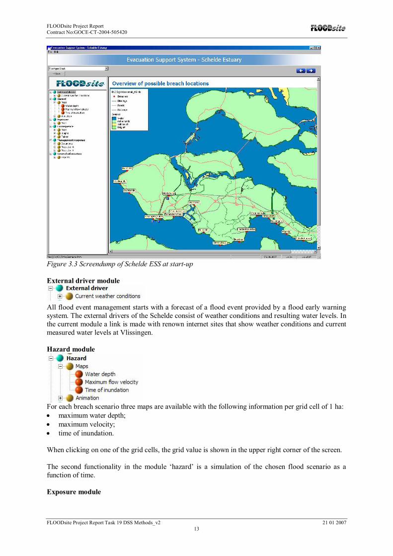
Functionality of the Schelde DSSThe prototype DSS for the Schelde pilot, called Evacuation Support System (ESS), has been builtfollowing the general framework as introduced in chapter 2. As the purpose of the ESS is evacuationmanagement, some modules of the framework can be left out or reduced. Figure 3.3 shows a screendump of the ESS as it appears on the screen after installing the software. On the left some of themodules as explained in the framework can be found. Below the modules are explained in more detail.The risk module is not added, because it contains the same information as the consequence module.The management response module only contains evacuation measures.
In the upper left corner, a drop down menu is present from which a ‘scenario’ can be chosen. Eachscenario represents a breach location or a set of breach locations. All available breach locations andtheir labels are presented on the overview map.
FLOODsite Project ReportContract No:GOCE-CT-2004-505420
FLOODsite Project Report Task 19 DSS Methods_v2 21 01 200713
Figure 3.3 Screendump of Schelde ESS at start-up
External driver module
All flood event management starts with a forecast of a flood event provided by a flood early warningsystem. The external drivers of the Schelde consist of weather conditions and resulting water levels. Inthe current module a link is made with renown internet sites that show weather conditions and currentmeasured water levels at Vlissingen.
Hazard module
For each breach scenario three maps are available with the following information per grid cell of 1 ha:maximum water depth;maximum velocity;time of inundation.
When clicking on one of the grid cells, the grid value is shown in the upper right corner of the screen.
The second functionality in the module ‘hazard’ is a simulation of the chosen flood scenario as afunction of time.
Exposure module

FLOODsite Project ReportContract No:GOCE-CT-2004-505420
FLOODsite Project Report Task 19 DSS Methods_v2 21 01 200714
For each breach scenario four maps are available with the location and number of inhabitants,livestock and infrastructure.Also a map with shelters is available. Tall and stable buildings and high areas are shown. Shelterscould be used to evacuate people to.
Consequence module
For each breach scenario three maps are available with an estimation of casualties, affected people andbuilding collapse. Both are derived from the velocity and water depth maps. The options ‘graphs’ and‘tables’ are available to compare consequences of different breach scenarios.
In future versions there will be a map with objects at risk (buildings that are likely to collapse,hospitals, etc.).When clicking on one of the objects, the user will obtain information for this object(name/id, information on consequences such as max. water depth and time of inundation).
Management response module
Several evacuation plans can be read, applied and compared. The consequences can be found in mapsagain. In a later stadium it will be possible to create evacuation plans in this ESS. Input from task 17 isneeded.
FLOODsite Project ReportContract No:GOCE-CT-2004-505420
FLOODsite Project Report Task 19 DSS Methods_v2 21 01 200715
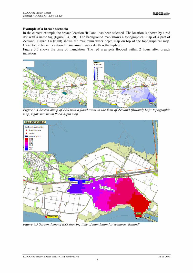
Example of a breach scenarioIn the current example the breach location ‘Rilland’ has been selected. The location is shown by a reddot with a name tag (figure 3.4, left). The background map shows a topographical map of a part ofZeeland. Figure 3.4 (right) shows the maximum water depth map on top of the topographical map.Close to the breach location the maximum water depth is the highest.Figure 3.5 shows the time of inundation. The red area gets flooded within 2 hours after breachinitiation.
Figure 3.4 Screen dump of ESS with a flood event in the East of Zeeland (Rilland) Left: topographicmap, right: maximum flood depth map
Figure 3.5 Screen dump of ESS showing time of inundation for scenario ‘Rilland’

FLOODsite Project ReportContract No:GOCE-CT-2004-505420
FLOODsite Project Report Task 19 DSS Methods_v2 21 01 200716
3.3 Urban flash floodsThe aim of the research will be validation on the available examples of applications of TELEMAC 2DSystem (www.telemacsystem.com) in order to derive the pragmatic approach to attribution of floodrisk in urban areas using 2D hydrodynamics including issues relative to crisis management. This willenable identification of the critical points in terms related to the representation of the complextopography, geometry of buildings, roads , sewers etc. to be taken into account for an appropriateurban flooding case studies so that they can be targeted for improvement in view of applying 2Dmodelling in crisis management (determination of evacuation path, vulnerable zones, etc.). Thestudy will be conducted on existing 2D model set-up for one of the urban areas situated in the southernFrance submitted to frequent flash floods due to intense concentrated precipitation.
This part of work will allow to derive a general set of recommendations for any 2D hazard assessmenttool.
The study will assess the existing regulations in some EU member states (France, UK, Germany) withrespect to urban flood risk prevention and in particular the link between 2D modelling approach andFlood Crisis Management plans for urban areas will be assessed and appropriate lessons related tomethodological guidelines and specification of additional tools in order to cope with existingregulations in France (Community Safeguard Plans) will be drawn. This part of work will contribute toManagement Response module.
The urban flash flood site will be an undisclosed city in the southern France. It will represent aborough situated in a densely urbanized area, where exist significant risks of flash flooding.Cooperation has been sought with appropriate municipal and county authorities of a mid-size urbanarea in southern France to use existing data and to make results of research available. An agreement onthis issue is expected in the beginning of March 2007, but guarantees exist at this moment. Thesensitivity of the problem makes it extremely delicate during the local election period, which will takeplace before summer 2007. If such agreement will not be established a "dematerialised" example,without reference to any particular city, will form the base for the application.

FLOODsite Project ReportContract No:GOCE-CT-2004-505420
FLOODsite Project Report Task 19 DSS Methods_v2 21 01 200717
4. References1. ARCADIS, TECHNUM & ALKYON (2004), Strategische MER, Ontwikkelingsschets 2010,
Schelde Estuarium. Onderzoek effecten van ontwikkelingen op de waterparameters. (In Dutch)
2. ERLICH M (2006), “OSIRIS - an example of citizen-oriented technology development in thearea of dissemination of information on flood risk management”, International Journal ofNatural Hazards, special issue : "Flooding in Europe: Risks and Challenges", Elsevier (inpress)
3. GOULDBY B, SAMUALS P, KLIJN F, MESSNER F, VAN OS A, SAYERS P &SCHANZE J (2004), Language of Risk - Project definitions, FLOODsite report T34-04-01.
4. IMDC (2005) Faserapport 1: Composietrandvoorwaarden MaatschappelijkeKostenBatenAnalyse Sigmaplan, Deelopdracht 1. Ministerie van de Vlaamse Gemeenschap.Antwerpen, Belgium
5. KLIJN, F. et all (unpublished) Long-term strategies for flood risk management, scenariodefinition and strategy design. FLOODsite report T14-05-01.
6. ASSELMAN, N, BAKONYI, P, GAUME, E, LOGTMEIJER, C, LUMBROSO, D &WOODS-BALLARD, B (2007), Review report of operational flood management methods andmodels. FLOODsite report T17-07-01.
7. MAATEN R, ERLICH M, VERSINI P A, GAUME E, LUMBROSO D, ASSELMAN N,HOOIJER A & DE BRUIJN K (2007), Review of flood event management Decision SupportSystems, FLOODsite report T19-07-01.


