Embed Size (px)
Citation preview

Meteorological, Hydrological and Climate Services to Support Risk Analysis
Philippe CAROFF Météo-France
Operational Head RSMC La Réunion(Tropical Cyclone Centre for the South-West Indian Ocean
Understand Risk Forum
Cape Town (4 July 2012)

Availability of tropical cyclone hazard information at national, regional scales
Examples of usage for risk modeling

OUTLINE
1. RSMCs : dedicated centres of expertise dealing with a majornatural hazard : tropical cyclones
2. Availability of tropical cyclone hazard information
3. Using tropical cyclone hazard information for risk modelling

1. RSMCs : dedicated centres of expertise dealing with a major natural hazard :
tropical cyclones

Tropical Cyclones30%
FloodsInondations
32%Other DisastersAutres
6%
EarthquakesTremblements de
terre10%
DroughtSécheresses
22%
AFFECTED AFFECTED AFFECTED AFFECTED PEOPLEPEOPLEPEOPLEPEOPLE
Tropical Cyclones
19%
FloodsInondations
26%
Other DisastersAutres
9%EarthquakesTremblements de
terres13%Drought
Sécheresse3%
StormsTempetes
6%
LandslidesGlissements
de terrain7%
EpidemicsEpidémies
17%
Tropical Cyclones
20%
Famines/Food Shortage
4%Drought
Sécheresses33%
FloodsInondations
32%Other Disasters
Autres7%
EarthquakesTremblements
de terre4%
DAMAGEDAMAGEDAMAGEDAMAGE
MORTALITYMORTALITYMORTALITYMORTALITY
Natural disasters in the world (1963-1992). Source United Nations.
Tropical cyclones :
a major natural hazard
Tropical cyclones :
a major natural hazard

Tropical cyclone activity worldwide
20-years of worldwide tropical cyclone activity as re presented by the global TC tracks for the period 198 5-2005.

Tropical cyclone basins
Tropical cyclone basins and their compared related TC activity
(based on the 1968-1990 period).
Tropical cyclone basins and their compared related TC activity
(based on the 1968-1990 period).From
A : Average annual number of tropical storms and tropic al cyclones
B : Average number of tropical cyclones (hurricanes)
C : Relative frequency of TC activity by basins (tropical storms and tropical cyclones)
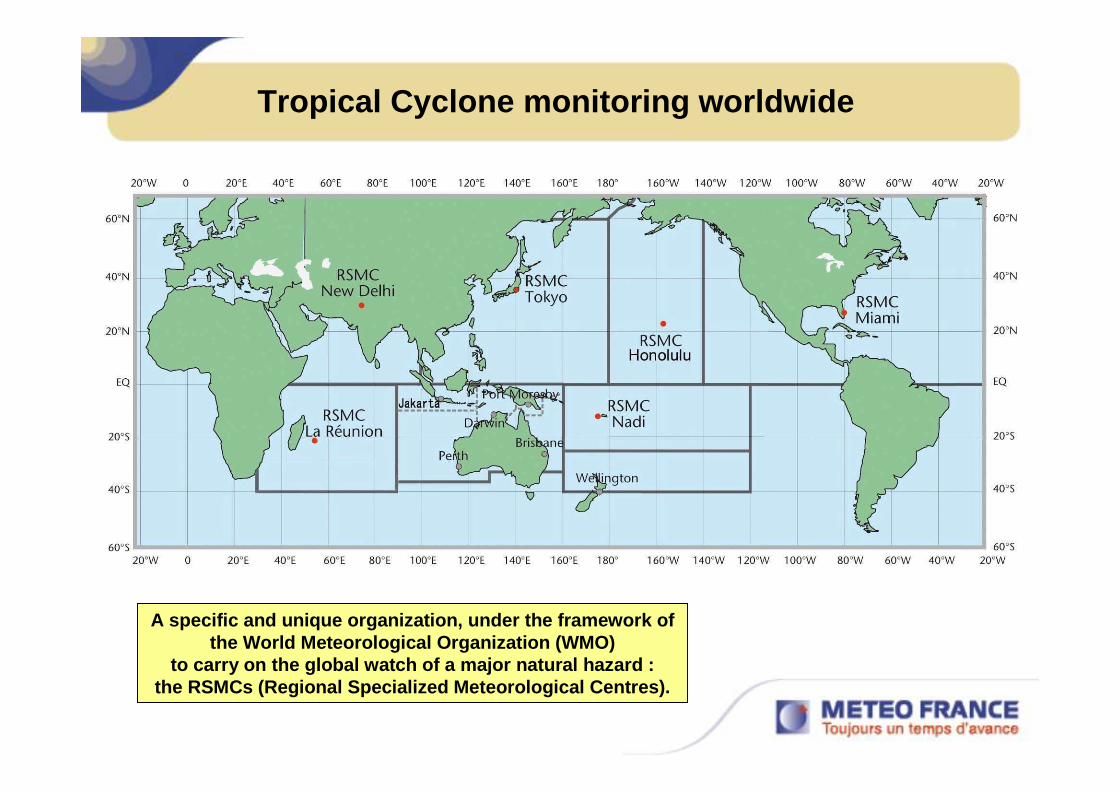
Tropical Cyclone monitoring worldwide
A specific and unique organization, under the framework ofthe World Meteorological Organization (WMO)
to carry on the global watch of a major natural hazard :the RSMCs (Regional Specialized Meteorological Centre s).

2000 to 2010 : almost 2000 deaths
2000 : ELINE, more than 800 deaths
HUDAH, 114 deaths
2003 : MANOU, more than 80 deaths
2004 : GAFILO, more than 400 deaths
2005 : ERNEST, more than 200 deaths (?)
2007 : INDLALA, 150 deaths
2008 : IVAN, 73 deaths at least
2010 : HUBERT, more than 85 deaths
Tropical cyclones : a major natural hazard for the South-West Indian Ocean as well

The 3 main missions of RSMC La Réunion :
• Operational tropical cyclone warning centre for the Southwest Indian Ocean: to provide the first-levelinformation (analyses, forecasts, guidance and warnings) on all the tropical disturbances forming or evolving within its AoR.
• Research : contribute to better knowledge on tropical cyclones and more specifically to improve the handling of tropical cyclones by the numerical models anddevelop new tools tailored for tropical cyclone forecasting.
• Formation : contribute toform the forecasters of thearea through training courses or attachment of forecasters.
The Meteo-France regional centre based at La Réunion Island officially started operating as the Tropical Cyclones / Regional Specialised Meteorological Centre (RSMC) for the South-West Indian Ocean in June 1993.
The Meteo-France regional centre based at La Réunion Island officially started operating as the Tropical Cyclones / Regional Specialised Meteorological Centre (RSMC) for the South-West Indian Ocean in June 1993.
RSMC La Réunion

Area of responsibility of RSMC La Réunion
International responsibility exerted for the benefi t of the National Meteorological Services of the 15 member count ries of the South-West Indian Ocean Tropical Cyclone Com mittee
in order to reduce the loss of lives and mitigate t he socio-economic damages caused by tropical cyclones.
International responsibility exerted for the benefi t of the National Meteorological Services of the 15 member count ries of the South-West Indian Ocean Tropical Cyclone Com mittee
in order to reduce the loss of lives and mitigate t he socio-economic damages caused by tropical cyclones.
SUD-OUEST

2. Availability of tropical cyclone hazard information
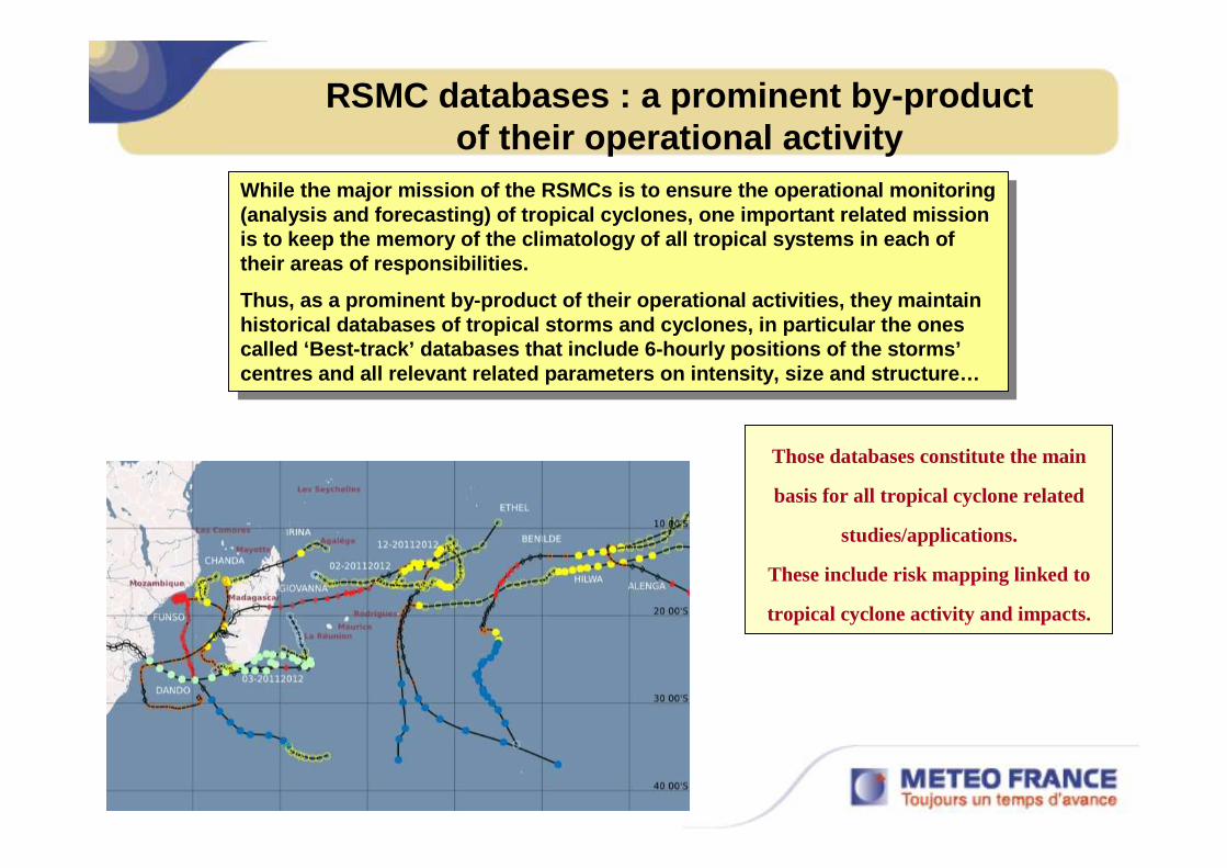
RSMC databases : a prominent by-product of their operational activity
While the major mission of the RSMCs is to ensure th e operational monitoring (analysis and forecasting) of tropical cyclones, on e important related mission is to keep the memory of the climatology of all trop ical systems in each of their areas of responsibilities.
Thus, as a prominent by-product of their operational activities, they maintain historical databases of tropical storms and cyclones, in particular the ones called ‘Best-track’ databases that include 6-hourly positions of the storms’ centres and all relevant related parameters on intens ity, size and structure…
Those databases constitute the main
basis for all tropical cyclone related
studies/applications.
These include risk mapping linked to
tropical cyclone activity and impacts.

Using best-track data for assessing TC hazard : loc al scale
Jenny (February 1962)Giselle (February - March 1964)Denise (January 1966)Hermine (January 1970)Hyacinthe (January 1980)Florine (January 1981)Firinga (February 1989)Colina (January 1993)Hollanda (February 1994)Dina (January 2002)
The ‘Best-Track’ database can be used for TC risk a ssesment and mapping at local scale (for instance for La Réun ion Island).
The ‘Best-Track’ database can be used for TC risk a ssesment and mapping at local scale (for instance for La Réun ion Island).
Tropical cyclones having passed less than 100 km from La Réunion Island
at hurricane force (tropical cyclone stage)
for the period 1961-2010.

Madagascar TC landfalls (1963 –2009)
North of 15S 15S-20S South of 20S
9 TCs19 TCs 13 TCs
Ivan – 17 February 2008
• 41 landfalls !! (almost one every year
in average)
• Mainly between 15S-20S
• 15% of landfalls along western coast

Madagascar TC landfalls (1963 –2009)
1993-1994 : "annus horribilis" for
Madagascar with 5 landfalls including
4 at intense tropical cyclone stage
BondoIndlala
Gamede
Favio2006-2007 TC seasonComposite image
Some active seasons with
much more than one TC
roaming near Madagascar
or hitting the island…TC Nadia
TC Geralda
TC LitanneTC Daisy
TS Julita
Tropical cycloneTropical Storm

Annual frequency of tropical cyclones : all data30 years period of reference (cyclone seasons 1969/1970 to 1998/1999).
Annual frequency of tropical cyclones : all data30 years period of reference (cyclone seasons 1969/1970 to 1998/1999).
Using best-track data for assessing TC hazard : regional or global scale

Using best-track data for assessing TC hazard : regional or global scale
Annual frequency of tropical cyclones : El Niño year s30 years period of reference (cyclone seasons 1969/1970 to 1998/1999).
Annual frequency of tropical cyclones : El Niño year s30 years period of reference (cyclone seasons 1969/1970 to 1998/1999).

Annual frequency of tropical cyclones : La Niña year s30 years period of reference (cyclone seasons 1969/1970 to 1998/1999).
Annual frequency of tropical cyclones : La Niña year s30 years period of reference (cyclone seasons 1969/1970 to 1998/1999).
Using best-track data for assessing TC hazard : regional or global scale

RSMC La Réunion historical database : the ongoing Re-analysis project (1)
To permit the best usage of the data for any study/ application on tropical cyclones (for instance to detect any trend in the t ime-evolution of TC activity – a critical issue being a potential link with globa l warming) it is of course crucial to provide the best quality-controlled data base.
It has therefore being recognized that a re-analysi s of past best-track data, in particular via the re-analysis of past satellite im agery, should be a high priority (major recommendation of IWTC-V and VI – In ternational Workshops on Tropical Cyclones).
Accordingly, RSMC La Réunion has undertaken a pluri- annual re-analysis project of past satellite data (focussing on the per iod 1978-1998) in order to rise the content and quality of its historical best- track database at the state-of the art level.

Plenty satellite pictures were
not available at La Réunion’s
Tropical Cyclone Centre in
the past (DMSP, NOAA orbits
outside of our scope of
acquisition, microwave
imagery) or have been more
or less poorly exploited
(Dvorak Technique not used
or inappropriately used …
no digital but "manually
gridded" hardcopy printouts
pictures.
RSMC La Réunion historical database : the ongoing Re-analysis project (2)
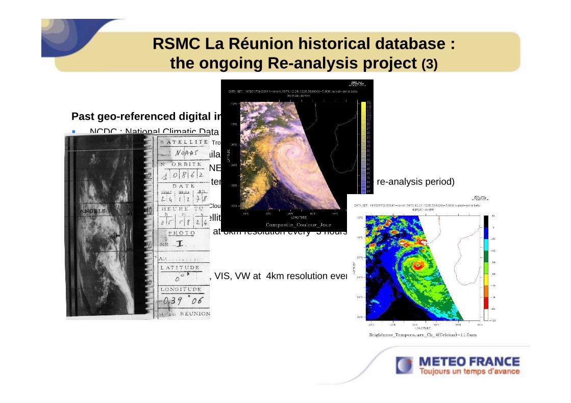
Past geo-referenced digital imagery now available� NCDC : National Climatic Data Center (Asheville)
– Digital Satellite Pictures focussed on Tropical Disturbances (HURricane SATellite).
• Easy to get on available ftp server.• Standard format (NETCDF)• Calibrated without temporal bias (fixed resolution over the re-analysis period)
– HURSAT-B1 (International Satellite Cloud Climatology Project (ISCCP) B1 ) :
• Geostationary satellites..– IR, VIS, VW at 8km resolution every 3 hours
– HURSAT-AVHRR :
• Avhrr satellites– Channels IR, VIS, VW at 4km resolution every 12 hours or more.
RSMC La Réunion historical database : the ongoing Re-analysis project (3)

3. Using tropical cyclone hazard information for risk modelling

Example of ongoing project about risk modelling (1)
An engineering firm (the JBA Risk Management Ltd) wi ll develop for the CCR (Caisse Centrale de Réassurance – a reinsurance company) a s ingle and multi-peril model for La Réunion Island dealing with the following meteorolo gical related hazards :
• sea surge flood
• windstorm
• surface water flooding (i.e. heavy rainfall – runoff) due to cyclone or non-cyclone events
The model will include both probabilistic and determ inistic components and additionally enable the analysis of individual scenario events.
The probabilistic model will be accompanied by dete rministic flood hazard maps for sea surge and surface water flood.
Hazard maps providing the extent and depth of flood ing for given return periods will be developed for sea surge and surface water flooding.
Inclusion of a ‘built environment model’ and of ‘vu lnerability functions’ relating hazard intensity (e.g. water depth or windspeed) to the expe cted mean damage ratio, and hence enabling the calculation of ground-up loss per prop erty in the probabilistic model, will enable the quantification of return period losses an d the output of a loss exceedance curve and event-by-event losses

Example of ongoing project about risk modelling (2)
Météo-France has been sollicited by the CCR for :
• providing access to its historical database of trop ical stormsin the South-West Indian Ocean basin
• providing access to the climatological records of wind and rainfall observations on La Réunion Island
• intervening as an expert to check the specificatio ns of the project
The development of the model will require the access to d ifferent databases(such as Bathymetry, Built environment data, Cyclone da ta, etc…).

Ongoing work at Météo-France La Réunion about storm s urge
Météo-France La Réunion has an ongoing project on t ropical cyclone induced storm surge.
Using the Météo-France storm surge model, first ste p will aim to generate an atlas of potential storm surge depending on TC intensity, TC structure (size, radius of maximum winds), track, etc… for a number of coastal sites o f the region (from Mozambique and Madagascar essentially) selected for their socio-eco nomic importance and/or vulnerability.
The database linked to this atlaswill serve as first-level guidance
for the tropical cycloneforecasters during operational
assessment of storm surge during real TC events.

Mapping of maximum potential storm surge at La Réun ion
Maximum height of sea level rise due to storm surge simulated with the Meteo-France storm surge model for La Réunion (figures in cm)
The work endeavoured for the coasts of Madagascar
and Mozambique will extend the similar studydone in the early 1990s when an atlas had been developed for mapping storm surge risk at La
Réunion.
The work endeavoured for the coasts of Madagascar
and Mozambique will extend the similar studydone in the early 1990s when an atlas had been developed for mapping storm surge risk at La
Réunion.

THANK YOU