Embed Size (px)
Citation preview
THE OHIO JOURNAL OF SCIENCE
VOL. LI SEPTEMBER, 1951 No. 5
THE GEOGRAPHIC PATTERN AND TRAFFIC PROBLEMSOF WARREN, OHIO1
RICHARD H. MERRELLDepartment of Geography, Kent State University, Kent, Ohio
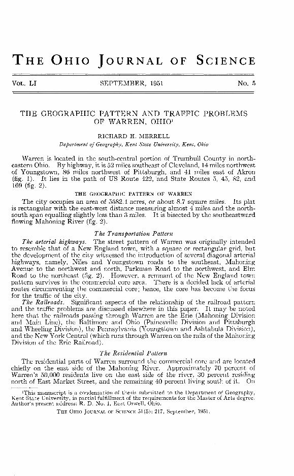
Warren is located in the south-central portion of Trumbull County in north-eastern Ohio. By highway, it is 52 miles southeast of Cleveland, 14 miles northwestof Youngstown, 86 miles northwest of Pittsburgh, and 41 miles east of Akron(fig. 1). It lies in the path of US Route 422, and State Routes 5, 45, 82, and169 (fig. 2).
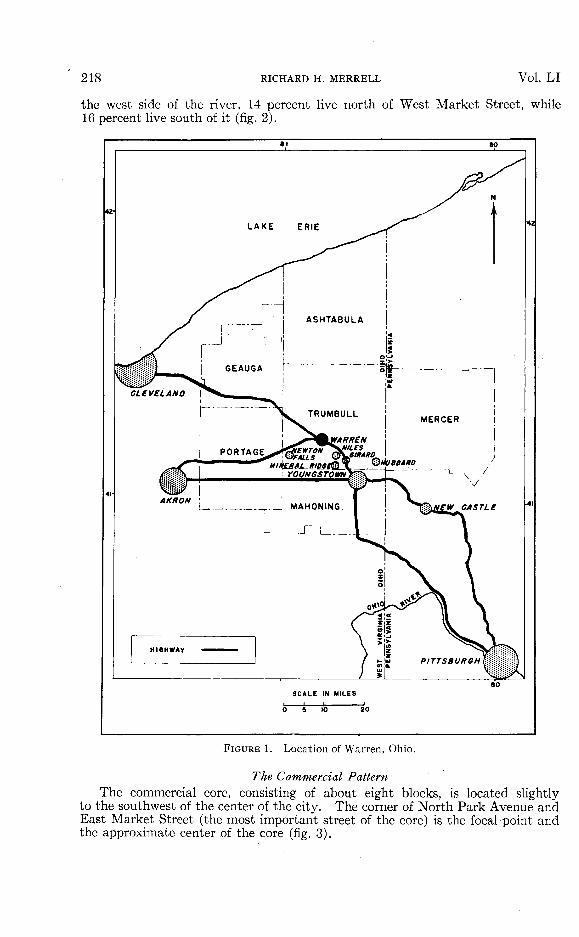
THE GEOGRAPHIC PATTERN OF WARRENThe city occupies an area of 5582.4 acres, or about 8.7 square miles. Its plat
is rectangular with the east-west distance measuring almost 4 miles and the north-south span equalling slightly less than 3 miles. It is bisected by the southeastwardflowing Mahoning River (fig. 2).
The Transportation PatternThe arterial highways. The street pattern of Warren was originally intended
to resemble that of a New England town, with a square or rectangular grid, butthe development of the city witnessed the introduction of several diagonal arterialhighways, namely, Niles and Youngstown roads to the southeast, MahoningAvenue to the northwest and north, Parkman Road to the northwest, and ElmRoad to the northeast (fig. 2). However, a remnant of the New England townpattern survives in the commercial core area. There is a decided lack of arterialroutes circumventing the commercial core; hence, the core has become the focusfor the traffic of the city.
The Railroads. Significant aspects of the relationship of the railroad patternand the traffic problems are discussed elsewhere in this paper. It may be notedhere that the railroads passing through Warren are the Erie (Mahoning Divisionand Main Line), the Baltimore and Ohio (Painesville Division and Pittsburghand Wheeling Division), the Pennsylvania (Youngstown and Ashtabula Division),and the New York Central (which runs through Warren on the rails of the MahoningDivision of the Erie Railroad).
The Residential PatternThe residential parts of Warren surround the commercial core and are located
chiefly on the east side of the Mahoning River. Approximately 70 percent ofWarren's 50,000 residents live on the east side of the river, 30 percent residingnorth of East Market Street, and the remaining 40 percent living south of it. On
irrhis manuscript is a condensation of thesis submitted to the Department of Geography,Kent State University, in partial fulfillment of the requirements for the Master of Arts degree.Author's present address: R. D. No. 1, East Orwell, Ohio.
THE OHIO JOURNAL OF SCIENCE 51(5): 217, September, 1951.
218 RICHARD H. MERRELL Vol. LI
the west side of the river, 14 percent live north of West Market Street, while16 percent live south of it (fig. 2).
LAKE ERIE
I I MAHONING
SCALE IN MILES
FIGURE 1. Location of Warren, Ohio.
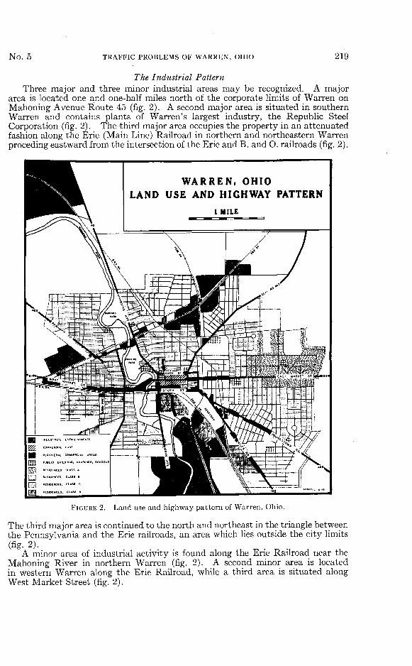
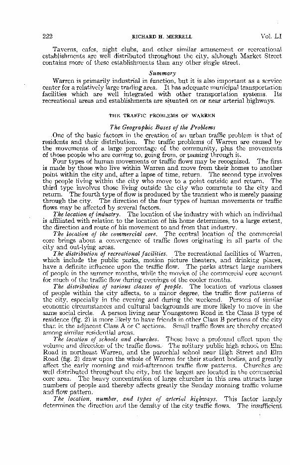
The Commercial PatternThe commercial core, consisting of about eight blocks, is located slightly
to the southwest of the center of the city. The corner of North Park Avenue andEast Market Street (the most important street of the core) is the focal point andthe approximate center of the core (fig. 3).
No. TRAFFIC PROBLEMS OF WARREN, OHIO 219
The Industrial PatternThree major and three minor industrial areas may be recognized. A major
area is located one and one-half miles north of the corporate limits of Warren onMahoning Avenue Route 45 (fig. 2). A second major area is situated in southernWarren and contains plants of Warren's largest industry, the Republic SteelCorporation (fig. 2). The third major area occupies the property in an attenuatedfashion along the Erie (Main Line) Railroad in northern and northeastern Warrenproceding eastward from the intersection of the Erie and B. and O. railroads (fig. 2).
WARREN, OHIOLAND USE AND HIGHWAY PATTERN
FIGURE 2. Land use and highway pattern of Warren, Ohio.
The third major area is continued to the north and northeast in the triangle betweenthe Pennsylvania and the Erie railroads, an area which lies outside the city limits(fig. 2).
A minor area of industrial activity is found along the Erie Railroad near theMahoning River in northern Warren (fig. 2). A second minor area is locatedin western Warren along the Erie Railroad, while a third area is situated alongWest Market Street (fig. 2).
TRAFFIC LIGHTONE-WAY STREETTWO-WAY STREETMETERED PARKINGPARKING LOTSPROPOSED PARKING
FIGURE 3. Commercial core and proposed one-way street system of Warren, Ohio
220 R
ICH
AR
D H
. MER
RELL
Vol.
LI
No. 5 TRAFFIC PROBLEMS OF WARREN, OHIO 221
SummaryThe industries of Warren are not concentrated in one portion of the city,
but rather are localized in five dispersed areas. Due to the lack of alternateroutes, the commercial core, which is located almost in the center of the city, isthe focus for the traffic of the city.
THE FUNCTIONS OF WARREN
The Industrial FunctionWarren is primarily an industrial city with 45 major industries which employ
22,000 people, or about two-fifths of Warren's total population. The city containsa number of diversified industries, although the primary metal industries employ37 percent of all industrial workers, and the electrical industries employ 25 percent.
The Commercial FunctionThe Warren Retail Merchants Association has estimated that the inhabitants
of Warren are responsible for 55 to 70 percent of the trade in the commercial corearea, and the Warren Chamber of Commerce has estimated that 97 percent ofTrumbull County's residents are served by Warren commercial establishments.With relation to the trading area of Warren, the writer conducted a survey ofautomobiles parked in the commercial core area of Warren on a weekday and aSaturday and found that 23 and 35 percent, respectively, of the sampled auto-mobiles were licensed outside of Warren. Seventy percent of the out-of-townautomobiles were licensed in communities within a fifteen mile radius of Warren.
The Residential FunctionThe residential function of Warren is becoming increasingly important. In
1940, 42,837 inhabitants of Warren occupied 11,342 dwelling units,2 and by theend of 1948, 50,000 people were occupying approximately 15,000 dwelling units.
The Transportation FunctionIntra-city transportation. Municipal bus service is supplied over nine regular
routes. Thirty buses cover a total of 68,500 miles and carry an average of 421,000passengers each month.3 Two taxicab companies operate 30 cabs and transporta monthly average of 40,000 passengers. Two Railway Express agencies and 15motor freight lines provide for the transportation of freight to points withinWarren.
Inter-city transportation. Passenger transportation to other cities is offeredby the Erie Railroad, and by numerous bus companies. Freight transporta-tion offered by all railroads and by motor freight lines. Regular bus serviceto many points surrounding Warren is offered, bus service between Warrenand Youngstown is most frequent. Warren is also a stopping point for manyinterstate buses, especially those traveling between Cleveland and Pittsburgh.
Private passenger automobiles. In 1948, over 16,000 motor vehicles wereregistered in Warren, of which about 13,000 were private passenger automobiles.4
The Recreational FunctionThere are three public parks in Warren; Packard and Perkins, the larger parks,
are located along the Mahoning River north of Market Street, while Quimby, thesmaller one, is located in southwest Warren (fig. 2).
Warren has five motion picture theaters, all of which are located in the com-mercial core.
2United States Bureau of the Census, Sixteenth Census of the United States, 1940: Housing,Vol. I, Part 2, (Washington: Gov't Printing Office, 1943), p. 219.
3The Warren Transportation Company.4Bureau of Motor Vehicles, Columbus, Ohio.
222 RICHARD H. MERRELL Vol. L I
Taverns, cafes, night clubs, and other similar amusement or recreationalestablishments are well distributed throughout the city, although Market Streetcontains more of these establishments than any other single street.
SummaryWarren is primarily industrial in function, but it is also important as a service
center for a relatively large trading area. It has adequate municipal transportationfacilities which are well integrated with other transportation systems. Itsrecreational areas and establishments are situated on or near arterial highways.
THE TRAFFIC PROBLEMS OF WARREN
The Geographic Bases of the ProblemsOne of the basic factors in the creation of an urban traffic problem is that of
residents and their distribution. The traffic problems of Warren are caused bythe movements of a large percentage of the community, plus the movementsof those people who are coming to, going from, or passing through it.
Four types of human movements or traffic flows may be recognized. The firstis made by those who live within Warren and move from their homes to anotherpoint within the city and, after a lapse of time, return. The second type involvesthe people living within the city who move to a point outside and return. Thethird type involves those living outside the city who commute to the city andreturn. The fourth type of flow is produced by the transient who is merely passingthrough the city. The direction of the four types of human movements or trafficflows may be affected by several factors.
The location of industry. The location of the industry with which an individualis affiliated with relation to the location of his home determines, to a large extent,the direction and route of his movement to and from that industry.
The location of the commercial core. The central location of the commercialcore brings about a convergence of traffic flows originating in all parts of thecity and out-lying areas.
The distribution of recreational facilities. The recreational facilities of Warren,which include the public parks, motion picture theaters, and drinking places,have a definite influence upon the traffic flow. The parks attract large numbersof people in the summer months, while the movies of the commercial core accountfor much of the traffic flow during evenings of the cooler months.
The distribution of various classes of people. The location of various classesof people within the city affects, to a minor degree, the traffic flow patterns ofthe city, especially in the evening and during the weekend. Persons of similareconomic circumstances and cultural backgrounds are more likely to move in thesame social circle. A person living near Youngstown Road in the Class B type ofresidence (fig. 2) is more likely to have friends in other Class B portions of the citythan in the adjacent Class A or C sections. Small traffic flows are thereby createdamong similar residential areas.
The location of schools and churches. These have a profound effect upon thevolume and direction of the traffic flows. The solitary public high school on ElmRoad in northeast Warren, and the parochial school near High Street and ElmRoad (fig. 2) draw upon the whole of Warren for their student bodies, and greatlyaffect the early morning and mid-afternoon traffic flow patterns. Churches arewell distributed throughout the city, but the largest are located in the commercialcore area. The heavy concentration of large churches in this area attracts largenumbers of people and thereby affects greatly the Sunday morning traffic volumeand flow pattern.
The location, number, and types of arterial highways. This factor largelydetermines the direction and the density of the city traffic flows. The insufficient
No. 5 TRAFFIC PROBLEMS OF WARREN, OHIO 223
number of alternate routes places an undue flow load upon the available highways.The convergence of arterial highways upon the commercial core practically pre-determines the traffic flow pattern. Furthermore, the width and condition ofthese highways largely determines the speed and density of moving traffic.
An Analysis of the Vehicular Traffic of WarrenThe bulk of the data for the analysis was obtained by taking traffic counts
at all entrances to the city on major highways, except Route 45 South, and at twolocations within Warren. An accurate count of vehicular traffic was recordedfrom 9 a.m. to 6 p.m. at city entrances for all days excepting Sunday, and from7 a.m. to 6 p.m. on the same days at two locations within the city.
Daily and hourly differentials of traffic entering and leaving Warren. Duringthe week the hour of heaviest traffic volume was between 4 and 5 p.m., whichwas due mainly to the fact that most industrial plants changed shifts at 4 p.m.On Saturday, the greatest number of vehicles entered Warren from 12 to 1 p.m.and departed from 2 to 3 p.m. The Saturday peak hours are largely causedby shoppers since few industrial plants operate more than a five-day week. TheSaturday traffic volume was from 2 to 33 percent greater than the average weekdayvolume, a fact which indicates the importance of Warren as a shopping centerfor the surrounding population.
Classes of vehicles entering and leaving Warren. Of all vehicles, private passengerautomobiles accounted for 78 percent; tractor-trailers, almost 4 percent; heavytrucks, 7 percent; light trucks, slightly over 8 percent; all buses, 1 percent; andtaxicabs and other vehicles, slightly over 1 percent. All trucks represented slightlyless than 20 percent of all vehicles.
Daily and hourly differentials of traffic within Warren. On West Market Streetat the bridge over the Mahoning River (fig. 3), the Saturday volume was 5 to 15percent greater than the v^eekday volume, while on Youngstown Road at thePennsylvania Railroad crossing (fig. 3), the average weekday volume was 8 percenthigher than the Saturday-volume. The highest volumes were recorded on Mondayand Saturday at the former location, and on Monday and Friday at the latter.
The peak hours of eastbound traffic at the Market Street location were from10 to 11 a.m. on Monday and Saturday, 3 to 4 p.m. on Tuesday, 3 to 5 p.m. onWednesday1, and 4 to 5 p.m. on Thursday and Friday, while the westbound peakhours were from 4 to 5 p.m. on Monday, Tuesday, Thursday and Friday, from3 4o 4 p.m. on Wednesday, and from 12 to 1 p.m. on Saturday. The eastboundpeak hours on Youngstown Road were from 4 to 5 p.m. on weekdays and from2 to 3 p.m. on Saturday, while the westbound peak hours were from 4 to 5 p.m. onMonday and Wednesday, 9 to 10 a.m. on Tuesday, 12 to 1 p.m. on Thursday andSaturday, and from 2 to 3 p.m. on Friday.
Classes of vehicles within Warren. All private passenger automobiles comprised80 percent of the vehicular traffic movements at the combined locations duringthe weekdays, and 82 percent on Saturday. All trucks accounted for almost16 percent during the weekdays and almost 14 percent on Saturday. All busesrepresented 1 percent. Taxicabs and other vehicles represented 2 percent onweekdays and almost 3 percent on Saturday.
Problems Resulting from the Mixture of Different Classes of TrafficIn the commercial core area, one of every six vehicles is a truck, and one of
every twenty vehicles is a tractor-trailer. These cumbersome, slow-movingvehicles have decreased the speed of the traffic flow, created a hazard for pedestriansat intersections where turning movements occur, and increased the possibilityof accidents when faster moving vehicles attempt to pass the slower moving trucks,and are a major factor in the problem of traffic congestion.
224 RICHARD H. MERRELL Vol. LI
Traffic CongestionCongestion of traffic is evident during peak hours in most parts of the commercial
core area. Congestion on East Market Street between Vine and Main avenuesis largely due to five factors: (1) it is the only east-west arterial highway; (2)East Market Street between North Park and Pine avenues is 13 feet narrower thanthe next block west, and seven feet narrower than the next block east, thus effectinga channelling of traffic into a narrow bottleneck; (3) it is designated as Route 5-82and carries a rather heavy volume of through traffic; (4) classes of traffic are inter-mixed; and (5) traffic lights are not adjusted for maximum vehicular flow.
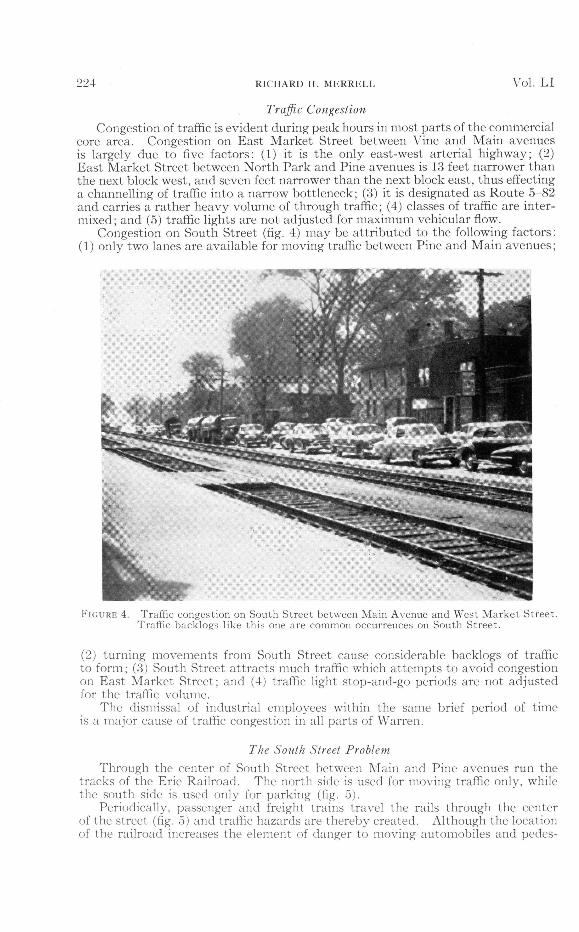
Congestion on South Street (fig. 4) may be attributed to the following factors:(1) only two lanes are available for moving traffic between Pine and Main avenues;
FIGURE 4. Traffic congestion on South Street between Main Avenue and West Market Street.Traffic backlogs like this one are common occurrences on South Street.
(2) turning movements from South Street cause considerable backlogs of trafficto form; (3) South Street attracts much traffic which attempts to avoid congestionon East Market Street; and (4) traffic light stop-and-go periods are not adjustedfor the traffic volume.
The dismissal of industrial employees within the same brief period of timeis a major cause of traffic congestion in all parts of Warren.
The South Street ProblemThrough the center of South Street between Alain and Pine avenues run the
tracks of the Erie Railroad. The north side is used for moving traffic only, whilethe south side is used only for parking (fig. 5).
Periodically, passenger and freight trains travel the rails through the centerof the street (fig. 5) and traffic hazards are thereby created. Although the locationof the railroad increases the element of danger to moving automobiles and pedes-
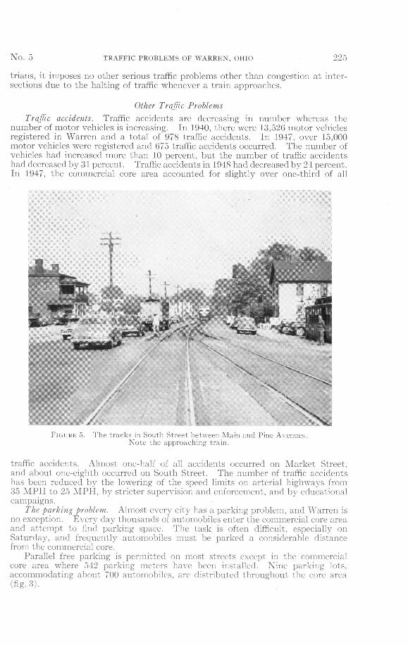
No. TRAFFIC PROBLEMS OF WARREN, OHIO 225
trians, it imposes no other serious traffic problems other than congestion at inter-sections due to the halting of traffic whenever a train approaches.
Other Traffic Problems
Traffic accidents. Traffic accidents are decreasing in number whereas thenumber of motor vehicles is increasing. In 1940, there were 13,526 motor vehiclesregistered in Warren and a total of 978 traffic accidents. In 1947, over 15,000motor vehicles were registered and 675 traffic accidents occurred. The number ofvehicles had increased more than 10 percent, but the number of traffic accidentshad decreased by 31 percent. Traffic accidents in 1948 had decreased by 24 percent.In 1947, the commercial core area accounted for slightly over one-third of all
FIGURE 5. The tracks in South Street between Main and Pine Avenues.Note the approaching train.
traffic accidents. Almost one-half of all accidents occurred on Market Street,and about one-eighth occurred on South Street. The number of traffic accidentshas been reduced by the lowering of the speed limits on arterial highways from35 MPH to 25 MPH, by stricter supervision and enforcement, and by educationalcampaigns.
The parking problem. Almost every city has a parking problem, and Warren isno exception. Every day thousands of automobiles enter the commercial core areaand attempt to find parking space. The task is often difficult, especially onSaturday, and frequently automobiles must be parked a considerable distancefrom the commercial core.
Parallel free parking is permitted on most streets except in the commercialcore area where 542 parking meters have been installed. Nine parking lots,accommodating about 700 automobiles, are distributed throughout the core area(fig-3).
226 RICHARD H. MERRELL Vol. LI
Summary and ConclusionsAmong the most serious of the traffic problems is the congestion of traffic
which is caused by many factors, including the lack of alternate routes, the mixtureof different classes of traffic, the dismissal of industrial employees from all plantsat approximately the same time, and inefficient traffic signal timing. If thisproblem were solved, or at least alleviated, other associated problems would becomeless serious.
The writer's analysis of the traffic problems has led him to believe that thefollowing proposals would go far toward improving the city traffic situation.
Approximately 11 percent of the vehicular traffic entering and leaving thecity is composed of tractor-trailers and heavy trucks. An assumption might bemade that over one-half of these trucks are through trucks, i.e., their destination isbeyond Warren and not in it. If this assumption is approximately correct, arerouting of through trucks around the city would decrease traffic congestion byconsiderably more than 6 or 7 percent, which is the percentage of total vehiclesto be rerouted. The routes encircling the city would involve a greater drivingdistance, but time lost because of distance would nearly equal time lost in Warrendue to congestion.
The second proposal calls for a series of one-way streets (fig. 3). This planwould certainly eliminate much of the congestion in the commercial core area, andin addition, would allow traffic to pass through Warren at a much faster rate.Third, the writer recommends that major industrial plants change shifts alternatelywith one hour intervals. Under this plan, industrial workers from the majorplants would not be on the streets at the same time; hence, much congestion wouldbe avoided. Fourth, part of a slum area south of South Street might be razed andparking facilities constructed (fig. 3). Commercial core parallel parking shouldbe prohibited. A fifth proposal calls for the installation of a centrally controlledtraffic light system with lights set at a progressive rate, i.e., lights that change togreen progressively as traffic moves along at a given rate of speed. This wouldallow traffic to move at a uniform speed through the city at almost twice its presentrate.
Sixth, the narrow block on East Market Street should be widened to correspondas closely as possible to the general width of the street. This would help eliminatecongestion in this and preceding blocks. The seventh proposal would result inpolice supervision at hazardous locations during peak hours. At present, policesupervision is evident at two intersections in the commercial core from 10 a.m. to12 p.m. and from 3 to 5 p.m., but these hours are not complete peak hours. Peakhours have been established by this study as being from 7 to 9 a.m. and 3 to 6 p.m.on weekdays, and from 10 a.m. to 3 p.m. on Saturday.
The eighth proposal would result in the widening of South Street, particularlythe portion which contains the railroad, so that heavy volumes of traffic will beable to move unimpeded along the street at a rapid rate. The ninth and finalproposal is that a press and radio campaign be inaugurated to persuade the publicto use bus transportation more frequently rather than their automobiles. Theresults of the campaign would probably decrease traffic congestion by a smallpercentage.
Instructions for preparation of manuscripts and illustrations for publication in theOhio Journal of Science may be obtained by writing to the Editor.