Embed Size (px)
Citation preview

September 4, 2019
MEMORANDUM CRC-19-24 TO: Coastal Resources Commission
FROM: Ken Richardson, Shoreline Management Specialist
SUBJECT: Consideration of Fiscal Analysis for the Inlet Hazard Area Boundary Update and Rule Amendments to 15A 7H .0304, 07H .0306, 07H. 0309 and 07H .0310
Background The establishment of Areas of Environmental Concern (AEC) is authorized under the NC Coastal Area Management Act (CAMA) of 1974 (NCGS 113A-100 et seq.) and forms the foundation of the North Carolina Coastal Resources Commission’s (CRC) permitting program for regulating coastal development. Rules defining three specific ocean hazard AECs appear in 15A NCAC 07H.0300: 1) Ocean Erodible, 2) Inlet Hazard, and 3) Unvegetated Beach AECs. The inlet hazard area (IHA) AEC is defined in 15A NCAC 07H.0301(3) as locations that “are especially vulnerable to erosion, flooding and other adverse effects of sand, wind, and water because of their proximity to dynamic ocean inlets.” Unlike other CRC jurisdictional areas, IHA boundaries are defined in a report referenced in the CRC’s rules at 7H.0304(2). The current IHA boundaries correspond to maps originally developed by Priddy and Carraway (1978) for all of the State’s then-active inlets. The report designating the IHA boundaries was adopted by the CRC in 1979, with minor amendments since that time. IHA boundaries in use today are based on statistical analysis (and to a lesser extent previous inlet location) of historical shoreline movement identified on multiple aerial photosets. In most cases, the statistical methods used in the 1978 study identified the landward-most shoreline position (99% confidence interval) projected to occur between 1978 and 1988. Originally, the Commission anticipated that these boundaries were to be updated at the end of the 1980s. However, due to a combination of factors, that update did not occur. In addition to the proposed rule amendments, the CRC is proposing to update the Inlet Hazard Area boundaries at the State’s developed inlets: Tubbs, Shallotte, Lockwoods Folly, Carolina Beach, Masonboro, Mason, Rich, New Topsail, New River and Bogue Inlets. Because the CRC’s
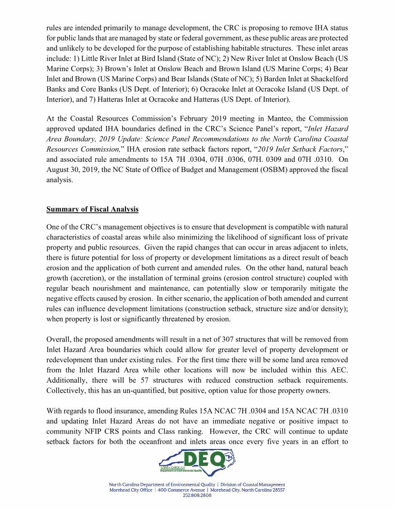
rules are intended primarily to manage development, the CRC is proposing to remove IHA status for public lands that are managed by state or federal government, as these public areas are protected and unlikely to be developed for the purpose of establishing habitable structures. These inlet areas include: 1) Little River Inlet at Bird Island (State of NC); 2) New River Inlet at Onslow Beach (US Marine Corps); 3) Brown’s Inlet at Onslow Beach and Brown Island (US Marine Corps; 4) Bear Inlet and Brown (US Marine Corps) and Bear Islands (State of NC); 5) Barden Inlet at Shackelford Banks and Core Banks (US Dept. of Interior); 6) Ocracoke Inlet at Ocracoke Island (US Dept. of Interior), and 7) Hatteras Inlet at Ocracoke and Hatteras (US Dept. of Interior). At the Coastal Resources Commission’s February 2019 meeting in Manteo, the Commission approved updated IHA boundaries defined in the CRC’s Science Panel’s report, “Inlet Hazard Area Boundary, 2019 Update: Science Panel Recommendations to the North Carolina Coastal Resources Commission,” IHA erosion rate setback factors report, “2019 Inlet Setback Factors,” and associated rule amendments to 15A 7H .0304, 07H .0306, 07H. 0309 and 07H .0310. On August 30, 2019, the NC State of Office of Budget and Management (OSBM) approved the fiscal analysis. Summary of Fiscal Analysis One of the CRC’s management objectives is to ensure that development is compatible with natural characteristics of coastal areas while also minimizing the likelihood of significant loss of private property and public resources. Given the rapid changes that can occur in areas adjacent to inlets, there is future potential for loss of property or development limitations as a direct result of beach erosion and the application of both current and amended rules. On the other hand, natural beach growth (accretion), or the installation of terminal groins (erosion control structure) coupled with regular beach nourishment and maintenance, can potentially slow or temporarily mitigate the negative effects caused by erosion. In either scenario, the application of both amended and current rules can influence development limitations (construction setback, structure size and/or density); when property is lost or significantly threatened by erosion. Overall, the proposed amendments will result in a net of 307 structures that will be removed from Inlet Hazard Area boundaries which could allow for greater level of property development or redevelopment than under existing rules. For the first time there will be some land area removed from the Inlet Hazard Area while other locations will now be included within this AEC. Additionally, there will be 57 structures with reduced construction setback requirements. Collectively, this has an un-quantified, but positive, option value for those property owners. With regards to flood insurance, amending Rules 15A NCAC 7H .0304 and 15A NCAC 7H .0310 and updating Inlet Hazard Areas do not have an immediate negative or positive impact to community NFIP CRS points and Class ranking. However, the CRC will continue to update setback factors for both the oceanfront and inlets areas once every five years in an effort to

contribute to an annual cost savings for property owners living in oceanfront communities by the avoidance of a five percent (5%) increase in flood insurance rates should the Coastal Resources Commission not update its construction setback factors. There will be approximately 219 structures that are currently not within an Ocean Hazard Area that will now be included within the updated IHA. Additionally, there will be approximately 137 structures that will experience an increased construction setback factor when compared to existing requirements. Per the current rule, all new construction will be limited to 5,000 heated square feet, with a density limit of no more than one unit per 15,000 square feet of land area. In contrast to current practice, commercial and residential structures will be treated equally for setback calculations in the proposed amendments. In a situation where a structure was destroyed or damaged beyond 50% and could not meet the construction setback, they still could potentially rebuild a structure on its original footprint and size if the structure was built before August 11, 2009 and meets certain grandfathering conditions in existing rules (15A NCAC 07H .0306(a)(5)(L)). Grandfathering applies single-family of all sizes, and commercial and multi-family 10,000 square feet or less. These proposed rule IHA amendments will not affect the application of these existing rules. Within the context of these rule amendments it is not anticipated that the $1M impact threshold would be exceeded, primarily because these amendments do not prevent development from occurring within the IHA. These rules only apply to new construction or redevelopment of an existing structure in the event that it is damaged beyond 50% of its appraised value. Existing structures can be rebuilt if they meet required setbacks, or if they do not meet setback requirements but can meet specified grandfathering conditions outlined in Rule 15A NCAC 07H. 0306(a)(5)(L). Although there will be 21 additional structures that cannot meet these IHA setback requirements, there will be 26 structures that will be able to meet setback compared to existing requirements; thus resulting in an overall benefit. If an existing structure cannot meet setback requirements, and also does not qualify for grandfathering, it is theoretically possible that future setback requirements could be met if vegetation grows seaward, or if erosion rates are reduced in a subsequent IHA update. With regards to the existing vacant lots within the proposed IHA (approximately 111 lots), these rule amendments do not restrict development on them, but they do limit structure size to 5,000 heated square feet, and development density to no more than one unit per 15,000 square feet of land area; the average size of structures adjacent to those 111 vacant lots is approximately 3,000 square feet. In a scenario where an existing vacant lot could not meet the setback requirements defined in this amendment, property owners could still potentially develop their property utilizing an existing rule (15A NCAC 07H. 0104) which allows for a structure up to 2,000 square feet to be constructed with minimal conditions.

There are unknowns and uncertainties associated with forecasting property owners’ intentions, storm magnitude and frequency, or barrier island responses to inlet and ocean forces. For this reason, it is impossible to estimate a monetary cost or benefit that can be directly attributed to these rule amendments, especially when they do not restrict development. It is certain that barrier islands can and do change, and when structures are more appropriately sited, they are better protected from the forces of the ocean0F
1 and can potentially save property owners and government agencies the costs associated with rebuilding, storm damage clean up, and erosion mitigation. Staff Recommendation The fiscal analysis was approved by the NC Department of Environmental Quality and Office of State Budget and Management on August 30, 2019. Should the Commission require no additional changes at this time, DCM staff are recommending that the Commission’s approve the fiscal analysis, and rule amendments. If approved, DCM Staff will proceed with public hearings. ATTACHMENT A: Fiscal Analysis
1 Carteret County Shore Protection Office, Hurricane Florence, November 2018: http://www.carteretcountync.gov/ArchiveCenter/ViewFile/Item/1297

ATTACHMENT A: Fiscal Analysis
Fiscal Analysis
2019 Update of Inlet Hazard Area Boundaries, Setback Factors, & Rule Amendments
15A NCAC 07H .0304, 15A NCAC 07H .0306, 15A NCAC 07H .0309, 15A NCAC 07H .0310
Prepared by
Ken Richardson Shoreline Management Specialist
Policy & Planning Section NC Division of Coastal Management
(252) 808-2808
August 26, 2019

Basic Information Agency DEQ, Division of Coastal Management (DCM) Coastal Resources Commission Title AREAS OF ENVIRONMENTAL CONCERN (AECS) WITHIN
OCEAN HAZARD AREAS, GENERAL USE STANDARDS FOR OCEAN HAZARD AREAS, & USE STANDARDS FOR INLET HAZARD AREAS
Citation 15A NCAC 7H .0304(2), 15A NCAC 07H .0306(A)(4), 15A
NCAC 7H .0309(C) AND 15A NCAC 07H .0310(A) Description of the Proposed Rule 7H.0304 defines and establishes Areas of Environmental
Concern (AECs) within the Ocean Hazard Areas along the State’s Atlantic Ocean shoreline. Ocean Hazard Area AECs include the Ocean Erodible Area, Inlet Hazard Area and the Unvegetated Beach Area; 7H. 0306 defines use standards with AECs; 7H.0309 defines use standards for OHA and exceptions, and; 07H.0310 defines use standards within Inlet Hazard Areas (IHAs).
Agency Contact Ken Richardson Shoreline Management Specialist [email protected]
(252) 808-2808 ext. 225 Authority G.S. 113A-107; 113A-113; 113A-124 Necessity The Coastal Resources Commission proposed amendments
to 15A NCAC 7H .0304(2), 15A NCAC 7H .0306(a)(4), 15A NCAC 7H .0309(c) and 15A NCAC 7H .0310(a) to reference proposed update of Inlet Hazard Area boundaries and associated development setback factors. The proposed rule change is in the public interest as it is intended to minimize the loss of property and human life by establishing development setbacks between structures and the Atlantic shoreline.
Impact Summary State government: No Local government: Uncertain Private Property Owners: Yes Substantial impact: No Federal government: No

Summary The establishment of Areas of Environmental Concern (AEC) is authorized under the NC Coastal Area Management Act (CAMA) of 1974 (NCGS 113A-100 et seq.) and forms the foundation of the North Carolina Coastal Resources Commission’s (CRC) permitting program for regulating coastal development. Rules defining three specific ocean hazard AECs appear in 15A NCAC 07H.0300: 1) Ocean Erodible, 2) Inlet Hazard, and 3) Unvegetated Beach AECs. The inlet hazard area (IHA) AEC is defined in 15A NCAC 07H.0301(3) as locations that “are especially vulnerable to erosion, flooding and other adverse effects of sand, wind, and water because of their proximity to dynamic ocean inlets.” Unlike other CRC jurisdictional areas, IHA boundaries are defined in a report referenced in the CRC’s rules at 7H.0304(2). The current IHA boundaries correspond to maps originally developed by Priddy and Carraway (1978) for all of the State’s then-active inlets. The report designating the IHA boundaries was adopted by the CRC in 1979, with minor amendments since that time. IHA boundaries in use today are based on statistical analysis (and to a lesser extent previous inlet location) of historical shoreline movement identified on multiple aerial photosets. In most cases, the statistical methods used in the 1978 study identified the landward-most shoreline position (99% confidence interval) projected to occur between 1978 and 1988. Originally, the Commission anticipated that these boundaries were to be updated at the end of the 1980s. However, due to a combination of factors, that update did not occur. The Coastal Resources Commission (CRC) seeks to amend Inlet Hazard Area (IHA) boundaries and its administrative rules governing structure size, development density, and siting of new construction within these areas more prone to erosion caused by inlet related processes. Introduction and Purpose Developed in 1978 and estimated to be applicable for approximately ten years, the State’s existing Inlet Hazard Area boundaries were intended to be updated before 1990. However, completing an update did not occur due to limited staff resources, insufficient data and mapping tools, and the lack of a defined method that could incorporate modern data and knowledge related to inlet geology and geomorphology. Geographically, the ends of barrier islands adjacent to inlets are constantly being reshaped by both natural (wind, currents, tides, waves) and manmade (dredging, beach nourishment, and erosion control structures) forces. In the event of a severe storm, these changes can occur very rapidly, and in time, many structures have been destroyed, with more than 347 platted parcels submerged

(Brunswick, Pender and Onslow Counties), and erosion control structures (sandbags, terminal groins) installed in order to slow erosion or protect structures. Currently, several existing IHA boundaries are spatially inaccurate as the inlet has migrated outside of the mapped boundary, and no longer accurately reflect the potential erosion hazards for actual developed portions of barrier islands that are adjacent to those inlets. In an effort to update IHA boundaries, the Coastal Resources Commission’s Science Panel and DCM Staff have collaborated on identifying appropriate data and best methods for calculating inlet shoreline erosion rates and defining new defined IHA boundaries. In addition to updating IHA boundaries, the CRC is proposing amendments to their rules. One of the CRC’s management objectives is to ensure that development is compatible with natural characteristics of coastal areas while also minimizing the likelihood of significant loss of private property and public resources (NCAC 07H.0203). At most inlets, the proposed IHA boundaries expand farther from the inlet along the oceanfront-inlet shoreline, and farther landward compared to existing IHA boundaries. Under the current rules, construction setback factors, which are based on erosion rates and used for siting new development, are calculated for the oceanfront (but not inside IHAs) approximately every five years. Instead, setback factors that are applied within the IHA are those of adjacent Ocean Erodible Areas (OEA) and do not reflect the actual erosion rates with the IHAs. This practice was necessary due to technological and methodological limitations in calculating erosion rates along inlet shorelines. By Applying this same practice to expanded IHA would misrepresent the erosion hazards associated with inlet areas. Now that the technology exists to calculate erosion rates along inlet shorelines, the CRC is proposing to amend their rules and allow the use of setback factors based on inlet erosion rates instead of using adjacent OEA oceanfront setback factors. Description of Rule Update 15A NCAC 7H .0304 15A NCAC 7H .0304 describes Areas of Environmental Concern (AEC) within Ocean Hazard Areas (OEA). In section 15A NCAC 7H .0304(2) the proposed amendment references the updated Inlet Hazard Area boundary report and maps titled “Inlet Hazard Area Boundary, 2019 Update: Science Panel Recommendations to the North Carolina Coastal Resources Commission.”1F
2 The methods used to calculate the inlet shoreline erosion rate setback factors2F
3 and for mapping the IHA boundaries can be found in the reports. Similar to how the Ocean Erodible Area is calculated on the oceanfront, landward IHA boundaries are heavily based on erosion rates multiplied by 90; however, expert (CRC’s Science Panel) consideration was also given to inlet-specific
2 Accessible at: https://files.nc.gov/ncdeq/Coastal%20Management/GIS/2019_Inlet_Hazard_Area_Boundary_Update_20190212.pdf 3 https://files.nc.gov/ncdeq/Coastal%20Management/GIS/2019_Inlet_Hazard_Area_Setback_Factors_20190212.pdf

geomorphology and underlying geology. It is important to note that factors of 30 have been used and accepted since 1980’s for the purpose of calculating construction setback and landward boundary of the Ocean Erodible Areas, and was initially based on the length of a typical mortgage (30 years). In section 15A NCAC 7H .0304(2)(a) of this Rule, the Inlet Hazard Area width cannot be less than the adjacent Ocean Erodible Area. However, these two AECs are mapped differently, and given that the IHA has remained static since 1979, while the OEA is updated approximately every five years, the resulting OEA boundary does not always conform to this requirement. In addition, there may be an erosion control structure (sandbag, terminal groin, navigational jetty) or unique geologic or geomorphologic barrier island feature that prevents the ability to meet this existing requirement. Therefore, the CRC is proposing that this requirement be removed. As mentioned above, the adjacent OEA setback factor is currently applied throughout the IHA. The CRC is proposing to utilize inlet setback factors that are based on actual inlet erosion rates instead of adjacent oceanfront rates. The report, “2019 Inlet Setback Factors” 3F
4 is referenced in 15A NCAC 7H .0304(2)(a) that includes the methodology and maps. As in Rule 15A NCAC 7H .0304(1) where the minimum setback factor of two is established, this section establishes the minimum setback factor of two within the IHA. 15A NCAC 07H .0309 Existing Rule 15A NCAC 07H .0309 describes the use standards and exemptions within Ocean Hazard Areas. Section 15A NCAC 07H .0309(c) of this rule prescribes conditions on the potential development of reconfigured lots that were platted prior to June 1, 1979. The intent of this rule was to not create a scenario where adjacent lots are combined and reconfigured in order to increase the number of buildable lots while also taking advantage of the grandfathering provisions in section 15A NCAC 07H .0309(b) of this rule. The CRC is proposing to remove section 15A NCAC 07H .0309(c) of this rule as it is not needed given that construction setbacks based on structure size is still required and does not change due to reconfiguring adjacent lots or lot size. 15A NCAC 07H .0310 Rule 15A NCAC 07H .0310 describes use standards for Inlet Hazard Areas. The intent of this existing rule is to limit the structure size and development density within the Ocean Hazard Areas that are more strongly influenced by inlet-related erosion than oceanfront processes. The existing rule in Section 15A NCAC 07H .0310(a)(1) requires the use of the adjacent Ocean Erodible Area (oceanfront) setback factor to be applied within the Inlet Hazard Area. Because the
4 https://files.nc.gov/ncdeq/Coastal%20Management/GIS/2019_Inlet_Hazard_Area_Setback_Factors_20190212.pdf

CRC is proposing the use of newly calculated inlet setback factors based on inlet erosion rates (referenced in proposed amendments to 15A NCAC 07H .0304), and not the adjacent oceanfront shoreline, the Commission is amending the rule to remove reference the adjacent ocean hazard area. The CRC is also proposing that inlet erosion rates and setback factors are to be updated once every five years, and to coincide with oceanfront erosion updates. The proposed addition of the new section 15A NCAC 07H .0310(a)(2) is included to reference existing rules pertaining to construction setback requirements in 15A NCAC 07H .0306(5). Additionally, this section references grandfathering provision for structures built prior to August 11, 2009 and no greater than 10,000 square feet in size. The intent of the existing section 15A NCAC 07H .0310(a)(2) is to limit development density of commercial and residential structures to one unit on lots less than 15,000 square feet of land area. The proposed amendment would change this to section 15A NCAC 07H .0310(a)(3) and remove the reference to “commercial or residential” since this rule applies to all structures regardless of use. Existing section 15A NCAC 07H .0310(a)(3) limits development density inside an IHA to four units or less for residential and commercial to less than 5,000 square feet. The proposed amendment would change this section to 15A NCAC 07H .0310(a)(4), and remove the distinction between residential and commercial, treating all structures equally, and limiting them to 5,000 square feet. The remaining amendments to 15A NCAC 07H .0310 are minor edits to existing rule language and do not change how the rule is currently applied. The draft amendment is located in Appendix A. Description of Boundary and Construction Setback Factor Update In addition to the proposed rule amendments, the CRC is proposing to update the Inlet Hazard Area boundaries at the State’s developed inlets: Tubbs, Shallotte, Lockwoods Folly, Carolina Beach, Masonboro, Mason, Rich, New Topsail, New River and Bogue Inlets. Because the CRC’s rules are intended to primarily manage development, the CRC is proposing to remove IHA status for public lands that are managed by state or federal government, as these public areas are protected and unlikely to be developed for the purpose of establishing habitable structures. These inlet areas include: 1) Little River Inlet at Bird Island (State of NC); 2) New River Inlet at Onslow Beach (US Marine Corps); 3) Brown’s Inlet at Onslow Beach and Brown Island (US Marine Corps; 4) Bear Inlet and Brown (US Marine Corps) and Bear Islands (State of NC); 5) Barden Inlet at Shackelford Banks and Core Banks (US Dept. of Interior); 6) Ocracoke Inlet at Ocracoke Island (US Dept. of Interior), and 7) Hatteras Inlet at Ocracoke and Hatteras (US Dept. of Interior).

While the size of the proposed IHA boundaries are reduced at some locations, overall they do encompass more land area compared to existing IHAs (Table 1). Collectively, IHAs are reduced by approximately 470 acres at Tubbs, Mason and New Topsail Inlets; and increased by approximately 1,800 acres for all others combined. Although the land area (~4,728 acres) inside the proposed IHAs does increase to some degree at most inlets, only 3% (~152 acres) of the total area is not already within the existing Ocean Hazard Area (IHAs, OEAs and Unvegetated Beach AECs). In other words, approximately 97% of the land area inside the proposed IHAs is already part of one of three existing AECs that make up the current Ocean Hazard Area, and already within the CRC’s jurisdiction. Table 1. Comparison of land area, not area over marsh or water, inside the existing and proposed IHAs. Positive land area difference values represent increases, and negative values represent decrease in size of the IHA. Approximately 152 acres is currently not within an Ocean Hazard AEC.
Inlet - Location
Land Area Inside
Existing IHA (acres)
Land Area Inside
Proposed IHA (acres)
Land Area Difference
(acres)
Land Area Currently Not inside an AEC (acres)
Tubbs Inlet - Sunset Beach 182 96.8 -85.2 0 Tubbs Inlet - Ocean Isle 123.5 84.3 -39.2 0 Shallotte Inlet - Ocean Isle 64.6 216.6 152 3.4 Shallotte Inlet - Holden Beach 290.5 569.3 278.8 76.4 Lockwood Folly Inlet - Holden Beach 64.1 189.5 125.4 2.3
Lockwood Folly Inlet - Oak Island 126.7 229.7 103 6.2 Carolina Beach Inlet - Carolina Beach 177.5 346 168.5 5.7
Masonboro Island - CB & Masonboro Inlets 75.6 535.5 459.9 0
Masonboro Inlet - Wrightsville Beach 0 90.8 90.8 9.4
Mason Inlet - Wrightsville Beach 267.6 125.5 -142.1 0.2 Mason Inlet - Figure Eight 267.6 165.6 -102 2.2 Rich Inlet - Figure Eight 156.2 253.6 97.4 21.3 Rich Inlet - Lea-Hutaff Island 117.7 409 291.3 0 New Topsail Inlet - Lea-Hutaff Island 517.1 414.4 -102.7 0
New Topsail Inlet - Topsail Beach 256.9 427.4 170.5 2.3 New River Inlet - N. Topsail Beach 85.2 144.8 59.6 5.3 Bogue Inlet - Emerald Isle 136.1 429.5 293.4 17.3
TOTAL: 2908.9 4728.3 1819.4 152 At many locations, the proposed IHA boundaries include areas that have historically been part of one of the Ocean Hazard AECs. Approximately 648 acres at developed inlets would be removed
from an IHA. At undeveloped inlets where land is publically owned and IHA boundaries are proposed to be removed, the total area that will not be included as an IHA is approximately 3,300 acres. For purposes of this analysis, “structures” are counted as one structure when they are physically connected; this includes multi-family and commercial. There are approximately 750 existing structures inside current IHAs, and a total of 945 within the proposed IHAs. Of the 750 structures inside the current IHAs, approximately 40% (307 structures) of those would not be included in the updated IHAs, nor would they be included within the OEA. This means that those 307 structures will no longer be in within an Ocean Hazard Area. Of the total 945 structures within the proposed IHAs, 443 (59%) of them are already located within an existing IHA, and 726 (77%) are currently located within one of three Ocean Hazard AECs. Because the proposed IHAs do expand and include approximately 152 acres of land, there will be approximately 217 structures that are not currently located within an Ocean Hazard AEC that will be included within the updated IHAs. Table 2. Comparison of the number of structures inside the existing and proposed IHAs; summary of the number of structures (219) that will be included in the updated IHA that are not currently within an Ocean Hazard Area (OHA), and; number of structures (307) that will be removed from the OHA as a result of the IHA update.
Inlet - Location Structures inside IHA-
Existing
Structures inside IHA-
Update
Structures inside IHA-Update not Currently
Inside OHA
Structures Removed
from OHA
Tubbs Inlet - Sunset Beach 203 16 0 187 Tubbs Inlet - Ocean Isle 56 31 0 20
Shallotte Inlet - Ocean Isle 0 110 8 0 Shallotte Inlet - Holden Beach 51 208 107 0
Lockwood Folly Inlet - Holden Beach 4 38 0 0 Lockwood Folly Inlet - Oak Island 31 69 13 0
Carolina Beach Inlet - Carolina Beach 0 19 4 0 Masonboro Island 0 0 0 0
Masonboro Inlet - Wrightsville Beach N/A 2 0 0 Mason Inlet - Wrightsville Beach 1 1 0 0
Mason Inlet - Figure Eight 36 20 0 31 Rich Inlet - Figure Eight 34 66 25 9
Rich Inlet - Lea-Hutaff Island 0 0 0 0 New Topsail Inlet - Lea-Hutaff Island 0 0 0 0
New Topsail Inlet - Topsail Beach 164 178 12 0 New River Inlet - N. Topsail Beach 68 95 10 5
Bogue Inlet - Emerald Isle 102 78 40 55 TOTAL: 750 931 219 307

Since 1980, the Division of Coastal Management has updated its oceanfront shoreline change rates approximately once every five years for calculating both oceanfront development setbacks and the landward boundary of the Ocean Erodible Area of Environmental Concern. The Commission is now proposing to utilized calculated erosion rates within IHAs to determine development setbacks. Due to technological and methodological limitations, the CRC has calculated development setbacks within existing IHA boundaries utilizing the erosion rate setback factors of the adjacent Ocean Erodible Area (NCAC 07H. 0310); which may not always be representative of the actual erosion associated with inlet-related processes. By applying the adjacent oceanfront shoreline setback factor inside the IHAs, and not using factors based on actual erosion rates at the inlet, the potential risk associated with inlet-induced erosion may not always reflected in the setback factors applied in determining construction setback. Table 3, Column (A) shows the range of calculated setback factors without applying the adjacent OEA factor as required by current rules; and Column (B) shows the range for the same area when the adjacent OEA factor is applied inside the existing IHA. The same comparison was made using proposed inlet setback factors with proposed rule amendments (Table 3, Column (C)), and; application of current rules with proposed inlet setback factors and boundary (Table 3, Column (D)). At specific inlets (Tubbs and Mason) the use of the adjacent OEA’s setback factor results in no change; while at others (Lockwoods Folly, New River, and Bogue Inlets), the use of the adjacent OEA’s setback factor applied within the IHA does significantly change the setback factor applied throughout the entire IHA.

Table 3. The geographical extent of setback factor (SBF) ranges in this table is the same area of land within the proposed IHAs. (A) represents the range of existing setback factors within the area of the proposed IHA boundary before applying the adjacent OEA setback factors within the current IHAs as required by existing Rules (15A NCAC 07H .0310); (B) illustrates the range of existing setback factors after applying the adjacent OEA setback factors within existing IHAs, and represents current requirements; (C) represents the proposed IHA setback factors and application of proposed rule amendments – and once adopted, would become the setback factors within the updated boundaries; (D) represents range of setback factors when existing rules are applied to the updated IHA and inlet setback factors. Both (A) and (D) illustrate how existing rules (15A NCAC 07H .0310) can influence setback factors.
Inlet - Location (A) (B)
(current IHAs & SBFs)
(C) (proposed IHAs
& SBFs) (D)
Tubbs Inlet - Sunset Beach 2 2 2 2 Tubbs Inlet - Ocean Isle 2 2 2 2 Shallotte Inlet - Ocean Isle 2 to 6.5 2 to 6.5 2 to 18 2 Shallotte Inlet - Holden Beach 2 2 2 to 5 2 Lockwood Folly Inlet - Holden Beach 2 to 8.5 3.5 to 7 2 to 5 3.5 Lockwood Folly Inlet - Oak Island 2 2 2 2 Carolina Beach Inlet - Carolina Beach 2 to 11.5 3 to 6.5 2 3 Masonboro Island (CB & Masonboro Inlets) 2 to 28 2 to 12.5 2 to 18 2 to 18 Masonboro Inlet - Wrightsville Beach 2 2 2 2 Mason Inlet - Wrightsville Beach 2 2 2 2 Mason Inlet - Figure Eight 2 2 2 2 Rich Inlet - Figure Eight 2 2 2 2 Lea-Hutaff Island (Rich and New Topsail Inlets)
2 to 10 2 to 10 2 to 37 2 to 37
New Topsail Inlet - Topsail Beach 2 2 2 2 New River Inlet - N. Topsail Beach 2 to 14 2 2 to 8 2 Bogue Inlet - Emerald Isle 2 to 12.5 2 2 to 4.5 2
Cost or Neutral Impacts Private Property Owners: The IHA rules only apply when property owners are seeking a Coastal Area Management Act (CAMA) permit for construction of new a structure, or replacement of an existing structure (requiring more than fifty percent (50%) repair) within the Inlet Hazard Area. The proposed rule amendments will remove existing distinctions between commercial and residential and require all structures: 1) to be limited to 5,000 square feet, and; 2) utilize IHA calculated setback factors, and not its adjacent oceanfront shoreline factor. It is important to note that current rules limiting development to no more than one unit per 15,000 square feet of land area, and grandfathering of structures that meet conditions in existing rules (15A NCAC 07H .0306(a)(5)(L) will still apply within the updated IHAs.

New construction: The two most notable influences that the updated IHA boundaries and rule amendments will have on new construction are: 1) the required use of erosion rate setback factors calculated for inlet areas and not that of the adjacent OEA, and; 2) both residential and commercial structures would be treated equally and limited to 5,000 square feet, and no more than one unit per 15,000 square feet of land area. Although both current and amended IHA rules have potential to limit size and density of new development, they do not specifically restrict a property owner’s ability to develop when higher rates of beach erosion are not measured or experienced. Currently there are approximately 425 platted lots adjacent to inlets that are completely submerged in the ocean or inlet or on the wet-sand beach. This alone demonstrates that geomorphology around inlets is very dynamic and have potential to change rapidly. For this reason, the CRC has traditionally taken the position that large-scale and dense development should be limited in areas adjacent to inlets. The 5,000 square feet size regulation has always applied to commercial development within IHAs because they have typically been thought of as being the largest structures when compared to single-family residential; especially during the early development of NC’s coast. Today, NC’s coast is experiencing the construction of large 24-bedroom “single-family” homes, which is an example of why the CRC treats all structures the same, regardless of its use. With regards to redevelopment of existing structures, it is not feasible to speculate on level of damages that might be caused by future storms, or speculate on the collective plans of property owners who might want to redevelop existing structures. Therefore, this section will focus only on how these rule amendments might affect existing vacant lots as a whole, regardless of ownership, or current use (public vs. private). Based on a random sampling of existing structures that are adjacent to vacant lots and within the updated IHAs, the average size of single-family residential structures is approximately 3,000 square feet (Table 4). The CRC is confident that the 5,000 square feet limit is sufficient for the development of vacant lots if they can meet the construction setback requirement. For the purpose of this analysis, a “vacant lot” simply means that there are no existing residential or commercial structures on the existing platted lot. Within existing IHAs, there are an estimated 113 vacant lots. Approximately 46% (52) of these lots currently do not have enough land area to allow for a structure to meet the minimum setback requirement based on current rules and erosion rate setback factors. Within the proposed updated IHA boundaries, the number of vacant lots increases by 60, making the total number of vacant lots estimated to be 173. Of 173 vacant lots, approximately 62 (36%) cannot meet the minimum construction setback; therefore, 111 (64%) of the vacant lots have potential to be developed to some degree should the owner chose to do so. Although this analysis does not examine why these lots are vacant, it should be noted that a portion of the 111 lots are owned by local government for the preservation of open space and public beach access, parking, and neighborhood common areas; while several have simply remained undeveloped.

Table 4. Average square footage of residential structures basef on a random sampling of structures adjacent to vacat lots and within the updated IHA. Although individual units within mult-family structures ranged from 640 to 1380 heated square feet, these averages do not consider multi-family structures as a whole. (*) indicates average based on structure physical footprint as determined using county tax data.
Inlet Location Heated Square Feet (Average)
Tubbs Inlet 3,600 Shallotte Inlet 3,700 Lockwood Folly Inlet 2,700 Carolina Beach Inlet 2,000* Masonboro Inlet NA Mason Inlet 3,400 Rich Inlet 3,500 New Topsail Inlet 2,000 New River Inlet 3,300 Bogue Inlet 3,200 AVERAGE 3,000
Repair of existing structures: Since 1979, the DCM oceanfront erosion rates have been used to calculate setback factors, and where there is accretion or rates are less than two feet per year, the default setback factor is two. Based on the 2019 inlet study and compared to existing setback requirements, 737 (79.2%) existing structures within the proposed Inlet Hazard Areas will experience no change in their development setback factor, 137 (14.7%) structures will experience an increase in construction setback factors, while 57 (6.1%) will have decreased setback factors (Table 5). It is important to note that where proposed inlet erosion rates will increase setback factors, all parcels and structures (100% of the 137) are in areas with known historically high erosion rates; however, because existing rules require the adjacent oceanfront shoreline setback factor to be applied inside the IHA, the setbacks for these locations have historically been lower than the proposed. Currently, 188 (20.2%) structures within the proposed IHA cannot meet the current minimum setback (60 feet, or SBF x 30). Using the proposed inlet setback factors, an additional 21 structures would not meet the minimum setback.

Table 5. Structure count summaries include all structures within the proposed IHAs, and they are counted as one structure when they are physically connected: (A) number of structures inside the proposed IHAs; (B) number of structures with no change in setback factors as a result of using inlet factors; (C) number of structures with increased setback factors; (D) number of structures with decreased setback factors; (E) number of structures that cannot meet the current minimum setback requirement, and (D) number of additional structures that could not meet the minimum setback using inlet calculated setback factors.
Inlet - Location (A) (B) (C) (D) (E) (D)
Tubbs Inlet - Sunset Beach 16 16 0 0 0 0 Tubbs Inlet - Ocean Isle 31 31 0 0 4 0 Shallotte Inlet - Ocean Isle 110 72 38 0 79 7 Shallotte Inlet - Holden Beach 208 208 0 0 0 0 Lockwood Folly Inlet - Holden Beach 38 0 0 38 35 -26 Lockwood Folly Inlet - Oak Island 69 69 0 0 0 0 Carolina Beach Inlet - Carolina Beach 19 0 0 19 1 0 Masonboro Island (CB & Masonboro Inlets) 0 0 0 0 0 0 Masonboro Inlet - Wrightsville Beach 2 2 0 0 0 0 Mason Inlet - Wrightsville Beach 1 1 0 0 0 0 Mason Inlet - Figure Eight 20 20 0 0 12 0 Rich Inlet - Figure Eight 66 66 0 0 13 0 Lea-Hutaff Island (Rich and New Topsail Inlets) 0 0 0 0 0 0 New Topsail Inlet - Topsail Beach 178 178 0 0 0 0 New River Inlet - N. Topsail Beach 95 21 74 0 36 9 Bogue Inlet - Emerald Isle 78 53 25 0 8 5
Total: 931 737 137 57 188 21 Percentage: 79.2% 14.7% 6.1% 20.2% 2.3%
Not meeting construction setback requirements based on existing or proposed setback factors and rules does not necessarily mean those same structures can never be rebuilt in the event they are destroyed or damaged beyond fifty percent. The reference feature from which development setbacks are measured, the first line of stable and natural vegetation (FLSNV), is determined in the field since it is dynamic and can change with the frequency and severity of storms and other factors common with inlet shorelines. The location of the first line of stable and natural vegetation can also be influenced by a community’s decision to construct a beach nourishment project. In time, the vegetation may respond and grow seaward with the beach, thus changing the point of reference from which the construction setback is measured. As previously mentioned, in a situation where a structure was destroyed and could not meet the construction setback, they still could potentially rebuild a structure on its original footprint and size if the structure was built before August 2009 and meets certain grandfathering conditions in existing rules (15A NCAC 07H .0306(a)(5)(L)). This grandfathering rule does not permit structures to be rebuilt in the original footprint and size if it was constructed after August 2009, and it cannot meet the required minimum setback.

Isolating or predicting the impact of state setback requirements on inlet and oceanfront property is difficult, if not impossible, since there are many statistically independent criteria that affect structure values. To examine these types of changes, economists use hedonic price models to decompose the total structure value into measurements for individual aspects of the structure such as size, age, number of bathrooms, location, and nearby amenities. Existing research indicates that erosion risks may decrease the value of oceanfront property but that this effect is overshadowed by the much larger positive value homebuyers place on being located directly next to the ocean.4F
5 Our ability to analyze this change is also complicated by different local construction ordinances which typically have additional structure setback distances that are measured from points of reference not presented in this document, but can potentially limit size or placement of a proposed structure on a lot. It is true that as the erosion rate increases, construction setback increases; however, depending on size of lot and structure, local government construction requirements (lot-side and street setback) in instances of home damage exceeding 50 percent of the structure value, the property owner may still be able to repair the structure to its original size. NC Department of Transportation (DOT): Pursuant to G.S. 150B-21.4, DCM DOT permitting staff reported that the proposed amendment to 7H.0304 will not affect environmental permitting for the NC Department of Transportation. Development such as roads, parking lots, and other public infrastructure such as utilities continue to have a minimum setback factor of sixty feet (60) or thirty (30) times the shoreline setback factor (whichever is greater) as defined by 07H.0306(a)(2)(I). In the event NC DOT needs to build or replace a road located within an Inlet Hazard AEC, DOT actions regarding the roadbed would likely be considered maintenance and repair and not affected by changes in the oceanfront setback factors. Local Government: Public infrastructure (roads, parking lots, & utilities) have a minimum setback factor of sixty feet (60) or thirty (30) times the shoreline erosion rate (whichever is greater) as defined by 07H.0306(a)(2)(I). In the event that local governments need to replace or rebuild public infrastructure within an Inlet Hazard AEC, the proposed amendments will not change the CRC’s approach to permitting that activity. With regards to local property and tax values, the CRC is confident that trying to quantify these values would be difficult if not impossible since there are statistically independent criteria that affect structure values along the coast. Existing research indicates that erosion risk may decrease the value of oceanfront property but that this affect is overshadowed by the much larger value homebuyers place on being located next to the ocean.3 and 5F
6
5Bin, O. and Kruse J.B. “Real Estate Market Response to Coastal Flood Hazards” Natural Hazards Review, 7:4. 2006.; Hindsley, P. “Applying Hedonic Property Models in the Planning and Evaluation of Shoreline Management” Presented at the Coastal Society’s 22nd International Conference in Wilmington North Carolina June 13, 2010. 6 Below, S., Beracha, E. and Skiba H. “Land Erosion and Coastal Home Values” Journal of Real Estate Research, Vol. 37, No. 4-2015

Division of Coastal Management: There will be a net increase of 181 structures within the IHAs (Table 2). However, because these changes will only apply to new development or replacement of an existing structure requiring more than fifty percent (50%) repair or re-construction, the Division of Coastal Management’s permit review process will not be changed by these amendments, and DCM does not anticipate changes in permitting receipts due to the proposed action. In terms of staff time required to do future updates of the IHA boundaries and erosion rate setback factors every five years, this process will be included as part of the existing practice of analyzing the oceanfront erosion rates and Ocean Erodible Areas. The same automated Geographical Information System (GIS) analysis already includes the option to analyze both the oceanfront and inlet erosion rates at the same time. Benefits Private Property Owners: One of the CRC’s management objectives is to ensure that development is compatible with natural characteristics of coastal areas while also minimizing the likelihood of significant loss of private property and public resources. IHA rules are intended to allow development to occur within areas adjacent to inlets while considering rates of erosion when siting the placement of new structures. Since these areas are very dynamic and can change rapidly, the CRC’s objective is to require the siting of new development to be in a more landward position when erosion rates are higher than average (approximately 2 feet/year.) Although there are two hundred and nineteen (219) structures that are currently not within an Ocean Hazard Area that will now be within the updated Inlet Hazard Areas, there will be three hundred and nine (307) structures that will be removed from the updated IHAs. With regards to proposed inlet setback requirements, approximately 794 (85.3%) of existing structures within the proposed IHAs will see no change, or either a setback factor reduction. Although purely speculative, properties within the existing or proposed IHAs could potentially be permitted and allowed re-development or expansion of the existing structure if new setback requirements can be met, and the total conditioned square footage does not exceed 5,000 square feet. It is not possible to estimate the exact value of this benefit without knowing how many property owners would choose to undertake expansion or redevelopment, or knowing specifics related to construction plans; however, where structures are removed from the IHA, or setback factors are reduced, it is estimated that this is potentially a positive net influence for those property owners if compared to existing more restrictive setback requirements. Although the erosion rates are often higher near inlets, it is important to note that National Flood Insurance Program (NFIP) does not consider the actual erosion rate when flood insurance rates are evaluated. NFIP only considers that fact that the State of North Carolina did, or did not, update its

erosion rates utilizing current data. NFIP requires this update to occur approximately once every five years. If the state does not, NFIP can then discredit fifty Community Rating System (CRS) points from all NC oceanfront communities with property inside a Special Flood Hazard area. Along the Atlantic shoreline (oceanfront and inlets), these areas are defined by the Velocity Zone, or V-Zone, and vary in size based on coastal region. In some areas this zone may extend across an entire barrier island, while in others it may only contain first or second row property. The NFIP does not consider the methodology for calculating setback factors, or the differences between the OEA and IHA; just that the fact that the State updates is setback factors once every five years. Updating inlet setback factors will coincide with the update of oceanfront setback factors. Regardless of the calculation methodology, the State will continue to update erosion rates in part to assure that communities do not lose CRS points. The loss of fifty CRS points would not have an immediate negative impact on those communities listed below in Table 6. However, several communities are scheduled to be reevaluated by NFIP in 2019 and 2020, and at that time could potentially benefit by having fifty points awarded and saving five percent in premiums as a direct result of NC updating erosion rates. Although this update alone does not guarantee a community will save five percent in premiums, the 50-points awarded could mean the difference between higher and lower NFIP Classes. Table 6. List of oceanfront communities participating in the Community Rating System (CRS). This table illustrates their current CRS Class, Special Flood Hazard Area (SFHA) Premium discount percentages, CRS points, and point score scenario subtracting 50 points. Based on current points, none of the listed communities would be impacted by the loss of fifty points. It should be noted that those communities identified with an asterisk (*) have an assigned CRS Class that does not correspond to their CRS Points because they did not meet FEMA’s prerequisites during their last evaluation; therefore, could not be placed in the Class tier based on scored points.
Community Current
CRS Class
% Discount
for SFHA(1)
% Discount for Non-SFHA
CRS Points
CRS Points (-50)
CRS Class Change if
Points Lost
1 Carolina Beach 6 20 10 2058 2008 No 2 Emerald Isle 7 15 5 1906 1856 No 3 Holden Beach 8 10 5 1181 1131 No 4 North Topsail Beach* 5* 25 10 3600 3550 No* 5 Oak Island* 7* 15 5 2258 2208 No* 6 Ocean Isle Beach* 8* 10 5 2088 2038 No* 7 Sunset Beach* 7* 15 5 2109 2059 No* 8 Topsail Beach 5 25 10 2597 2547 No 9 Wrightsville Beach 7 15 5 1768 1718 No

Cost/Benefit Summary One of the CRC’s management objectives is to ensure that development is compatible with natural characteristics of coastal areas while also minimizing the likelihood of significant loss of private property and public resources. Given the rapid changes that can occur in areas adjacent to inlets, there is future potential for loss of property or development limitations as a direct result of beach erosion and the application of both current and amended rules. On the other hand, natural beach growth (accretion), or the installation of terminal groins (erosion control structure) coupled with regular beach nourishment and maintenance, can potentially slow or temporarily mitigate the negative effects caused by erosion. In either scenario, the application of both amended and current rules can influence development limitations (construction setback, structure size and/or density); when property is lost or significantly threatened by erosion. Overall, the proposed amendments will result in a net of 307 structures that will be removed from Inlet Hazard Area boundaries which could allow for greater level of property development or redevelopment than under existing rules. For the first time there will be some land area removed from the Inlet Hazard Area while other locations will now be included within this AEC. Additionally, there will be 57 structures with reduced construction setback requirements. Collectively, this has an un-quantified, but positive, option value for those property owners. With regards to flood insurance, amending Rules 15A NCAC 7H .0304 and 15A NCAC 7H .0310 and updating Inlet Hazard Areas do not have an immediate negative or positive impact to community NFIP CRS points and Class ranking. However, the CRC will continue to update setback factors for both the oceanfront and inlets areas once every five years in an effort to contribute to an annual cost savings for property owners living in oceanfront communities by the avoidance of a five percent (5%) increase in flood insurance rates should the Coastal Resources Commission not update its construction setback factors. There will be approximately 219 structures that are currently not within an Ocean Hazard Area that will now be included within the updated IHA. Additionally, there will be approximately 137 structures that will experience an increased construction setback factor when compared to existing requirements. In contrast to current practice, both commercial and residential structures will be treated equally in the proposed amendments, and all new construction will be limited to 5,000 heated square feet, and with a density limit of no more than one unit per 15,000 square feet of land area. In a situation where a structure was destroyed or damaged beyond 50% and could not meet the construction setback, they still could potentially rebuild a structure on its original footprint and size if the structure was built before August 11, 2009 and meets certain grandfathering conditions in existing rules (15A NCAC 07H .0306(a)(5)(L)). Grandfathering applies single-family of all sizes and multi-family 10,000 square feet or less. These proposed rule amendments will not affect the application of these existing rules. Within the context of these rule amendments it is not anticipated that the $1M impact threshold would be exceeded primarily because these amendments do not prevent development from occurring within the IHA. These rules only apply to new construction or redevelopment of an existing structure in the event that it is damaged beyond 50% of its appraised value. Existing

structures can be rebuilt if they meet required setbacks, or if they do not meet setback requirements but can meet specified grandfathering conditions outlined in Rule 15A NCAC 07H. 0306(a)(5)(L). Although there will be 21 additional structures that cannot meet these IHA setback requirements, there will be 26 structures that can now meet setback compared to existing requirements (Table 5, Column D); thus resulting in an overall benefit. Furthermore, by not meeting setback requirements this doesn’t necessarily mean the structure would be damaged fifty-percent or more during a storm, or need a CAMA permit to do repairs. If an existing structure cannot meet setback requirements, and also does not qualify for grandfathering, it is theoretically possible that future setback requirements could be met if erosion rates are reduced as a result of natural accretion, beach nourishment, or construction of a terminal groin. With regards to the existing vacant lots within the proposed IHA (approximately 111 lots), these rule amendments do not restrict development on them, but they do limit structure size to 5,000 heated square feet and development density to no more than one unit per 15,000 square feet of land area. As illustrated in Table 4, the average size of structures adjacent to those 111 vacant lots is approximately 3,000 square feet, and the CRC feels that the size limit is sufficient in meeting their management objectives. In a scenario were an existing vacant lot could not meet the setback requirements defined in this amendment, property owners could still potentially develop their property utilizing an existing rule (15A NCAC 07H. 0104) which allows for a structure up to 2,000 square feet to be constructed with minimal conditions. There are unknowns and uncertainties associated with forecasting property owner’s intentions, storm magnitude and frequency, or barrier island responses to inlet and ocean forces. For this reason, it is impossible to estimate a monetary cost or benefit that can be directly attributed to these rule amendments, especially when they do not restrict development. It is certain that barrier islands can and do change, and when structures are more appropriately sited, they are better protected from the forces of the ocean6F
7 and can potentially save property owners and government agencies the cost associated with rebuilding, storm damage clean up, and erosion mitigation. References Below, S., Beracha, E., Skiba, H. (2015). Land Erosion and Coastal Home Values. Journal of Real Estate Research, 37(4), 499-536. Federal Emergency Management Agency (FEMA), 2019, Calculation of Flood Insurance, https://www.fema.gov/faq-details/Calculation-of-Flood-Insurance
7 Carteret County Shore Protection Office, Hurricane Florence, November 2018: http://www.carteretcountync.gov/ArchiveCenter/ViewFile/Item/1297

Appendix A: Proposed Rule Amendments 15A NCAC 07H .0304 AECS WITHIN OCEAN HAZARD AREAS
The ocean hazard AECs contain all of the following areas:
(1) Ocean Erodible Area. This is the area where there exists a substantial possibility of excessive
erosion and significant shoreline fluctuation. The oceanward boundary of this area is the mean low
water line. The landward extent of this area is the distance landward from the first line of stable and
natural vegetation as defined in 15A NCAC 07H .0305(a)(5) to the recession line established by
multiplying the long-term annual erosion rate times 90; provided that, where there has been no
long-term erosion or the rate is less than two feet per year, this distance shall be set at 180 feet
landward from the first line of stable natural vegetation. For the purposes of this Rule, the erosion
rates are the long-term average based on available historical data. The current long-term average
erosion rate data for each segment of the North Carolina coast is depicted on maps entitled "2011
Long-Term Average Annual Shoreline Rate Update" and approved by the Coastal Resources
Commission on May 5, 2011 (except as such rates may be varied in individual contested cases or in
declaratory or interpretive rulings). In all cases, the rate of shoreline change shall be no less than
two feet of erosion per year. The maps are available without cost from any Local Permit Officer or
the Division of Coastal Management on the internet at http://www.nccoastalmanagement.net.
(2) Inlet Hazard Area. The inlet hazard areas are natural-hazard areas that are especially vulnerable to
erosion, flooding, and other adverse effects of sand, wind, and water because of their proximity to
dynamic ocean inlets. This area extends landward from the mean low water line a distance sufficient
to encompass that area within which the inlet migrates, based on statistical analysis, and shall
consider such factors as previous inlet territory, structurally weak areas near the inlet, and external
influences such as jetties and channelization. The areas on the maps identified as suggested Inlet
Hazard Areas included in the report entitled INLET HAZARD AREAS, The Final Report and
Recommendations to the Coastal Resources Commission, 1978, as amended in 1981, by Loie J.
Priddy and Rick Carraway “Inlet Hazard Area Boundary, 2019 Update: Science Panel
Recommendations to the North Carolina Coastal Resources Commission” are incorporated by
reference and are hereby designated as Inlet Hazard Areas, except for:
(a) inlets providing access to a State Port via a channel maintained by the United States Army
Corps of Engineers
In all cases, the Inlet Hazard Area shall be an extension of the adjacent ocean erodible areas
and in no case shall the width of the inlet hazard area be less than the width of the adjacent
ocean erodible area. This report is available for inspection at the Department of
Environmental Quality, Division of Coastal Management, 400 Commerce Avenue,
Morehead City, North Carolina or at the website referenced in Item (1) of this Rule.

For the purposes of this Rule, Inlet Hazard Area setback factors are based on the long-term average
annual shoreline change rates calculated using methods detailed in the report entitled “Inlet Hazard
Area Boundary, 2019 Update: Science Panel Recommendations to the North Carolina Coastal
Resources Commission”. Inlet Hazard Area setback factors are depicted on maps entitled "2019
Inlet Setback Factors” and approved by the Coastal Resources Commission on February 28, 2019
(except as such rates may be varied in individual contested cases or in declaratory or interpretive
rulings). In all cases, Inlet Hazard Area construction setback factors shall be no less than two where
accretion rates are measured, or erosion rates are less than two feet per year. The maps are available
without cost from any Local Permit Officer or the Division of Coastal Management or at the website
referenced in Item (1) of this Rule.
(3) Unvegetated Beach Area. Beach areas within the Ocean Hazard Area where no stable natural
vegetation is present may be designated as an Unvegetated Beach Area on either a permanent or
temporary basis as follows:
(a) An area appropriate for permanent designation as an Unvegetated Beach Area is a dynamic
area that is subject to rapid unpredictable landform change due to wind and wave action.
The areas in this category shall be designated following studies by the Division of Coastal
Management. These areas shall be designated on maps approved by the Coastal Resources
Commission and available without cost from any Local Permit Officer or the Division of
Coastal Management on the internet at the website referenced in Item (1) of this Rule.
(b) An area that is suddenly unvegetated as a result of a hurricane or other major storm event
may be designated by the Coastal Resources Commission as an Unvegetated Beach Area
for a specific period of time, or until the vegetation has re-established in accordance with
15A NCAC 07H .0305(a)(5). At the expiration of the time specified or the re-establishment
of the vegetation, the area shall return to its pre-storm designation.
History Note: Authority G.S. 113A-107; 113A-107.1; 113A-113; 113A-124;
Eff. September 9, 1977;
Amended Eff. December 1, 1993; November 1, 1988; September 1, 1986; December 1, 1985;
Temporary Amendment Eff. October 10, 1996;
Amended Eff. April 1, 1997;
Temporary Amendment Eff. October 10, 1996 Expired on July 29, 1997;
Temporary Amendment Eff. October 22, 1997;
Amended Eff. July 1, 2016; September 1, 2015; May 1, 2014; February 1, 2013; January 1, 2010;
February 1, 2006; October 1, 2004; April 1, 2004; August 1, 1998.

15A NCAC 07H .0306 GENERAL USE STANDARDS FOR OCEAN HAZARD AREAS
(a) In order to protect life and property, all development not otherwise specifically exempted or allowed by law or
elsewhere in the Coastal Resources Commission's rules shall be located according to whichever of the following is
applicable:
(1) The ocean hazard setback for development shall be measured in a landward direction from the
vegetation line, the static vegetation line, or the measurement line, whichever is applicable.
(2) In areas with a development line, the ocean hazard setback shall be set in accordance with
Subparagraphs (a)(3) through (9) of this Rule. In no case shall new development be sited seaward
of the development line.
(3) In no case shall a development line be created or established on state owned lands or oceanward of
the mean high water line or perpetual property easement line, whichever is more restrictive.
(4) The ocean hazard setback shall be determined by both the size of development and the shoreline
long term erosion rate as defined in Rule .0304 of this Section 15A NCAC 07H .0304. "Development
size" is defined by total floor area for structures and buildings or total area of footprint for
development other than structures and buildings. Total floor area includes the following:
(A) The total square footage of heated or air-conditioned living space;
(B) The total square footage of parking elevated above ground level; and
(C) The total square footage of non-heated or non-air-conditioned areas elevated above ground
level, excluding attic space that is not designed to be load-bearing.
Decks, roof-covered porches, and walkways shall not be included in the total floor area unless they
are enclosed with material other than screen mesh or are being converted into an enclosed space
with material other than screen mesh.
(5) With the exception of those types of development defined in 15A NCAC 07H .0309, no
development, including any portion of a building or structure, shall extend oceanward of the ocean
hazard setback. This includes roof overhangs and elevated structural components that are
cantilevered, knee braced, or otherwise extended beyond the support of pilings or footings. The
ocean hazard setback shall be established based on the following criteria:
(A) A building or other structure less than 5,000 square feet requires a minimum setback of 60
feet or 30 times the shoreline erosion rate, whichever is greater;
(B) A building or other structure greater than or equal to 5,000 square feet but less than 10,000
square feet requires a minimum setback of 120 feet or 60 times the shoreline erosion rate,
whichever is greater;
(C) A building or other structure greater than or equal to 10,000 square feet but less than 20,000
square feet requires a minimum setback of 130 feet or 65 times the shoreline erosion rate,
whichever is greater;
(D) A building or other structure greater than or equal to 20,000 square feet but less than 40,000
square feet requires a minimum setback of 140 feet or 70 times the shoreline erosion rate,
whichever is greater;

(E) A building or other structure greater than or equal to 40,000 square feet but less than 60,000
square feet requires a minimum setback of 150 feet or 75 times the shoreline erosion rate,
whichever is greater;
(F) A building or other structure greater than or equal to 60,000 square feet but less than 80,000
square feet requires a minimum setback of 160 feet or 80 times the shoreline erosion rate,
whichever is greater;
(G) A building or other structure greater than or equal to 80,000 square feet but less than
100,000 square feet requires a minimum setback of 170 feet or 85 times the shoreline
erosion rate, whichever is greater;
(H) A building or other structure greater than or equal to 100,000 square feet requires a
minimum setback of 180 feet or 90 times the shoreline erosion rate, whichever is greater;
(I) Infrastructure that is linear in nature, such as roads, bridges, pedestrian access such as
boardwalks and sidewalks, and utilities providing for the transmission of electricity, water,
telephone, cable television, data, storm water, and sewer requires a minimum setback of
60 feet or 30 times the shoreline erosion rate, whichever is greater;
(J) Parking lots greater than or equal to 5,000 square feet require a setback of 120 feet or 60
times the shoreline erosion rate, whichever is greater;
(K) Notwithstanding any other setback requirement of this Subparagraph, a building or other
structure greater than or equal to 5,000 square feet in a community with a static line
exception in accordance with 15A NCAC 07J .1200 requires a minimum setback of 120
feet or 60 times the shoreline erosion rate in place at the time of permit issuance, whichever
is greater. The setback shall be measured landward from either the static vegetation line,
the vegetation line, or measurement line, whichever is farthest landward; and
(L) Notwithstanding any other setback requirement of this Subparagraph, replacement of
single-family or duplex residential structures with a total floor area greater than 5,000
square feet, and commercial and multi-family residential structures with a total floor area
no greater than 10,000 square feet, shall be allowed provided that the structure meets the
following criteria:
(i) the structure was originally constructed prior to August 11, 2009;
(ii) the structure as replaced does not exceed the original footprint or square footage;
(iii) it is not possible for the structure to be rebuilt in a location that meets the ocean
hazard setback criteria required under Subparagraph (a)(5) of this Rule;
(iv) the structure as replaced meets the minimum setback required under Part (a)(5)(A)
of this Rule; and
(v) the structure is rebuilt as far landward on the lot as feasible.
(6) If a primary dune exists in the AEC on or landward of the lot where the development is proposed,
the development shall be landward of the crest of the primary dune, the ocean hazard setback, or
development line, whichever is farthest from vegetation line, static vegetation line, or measurement

line, whichever is applicable. For existing lots, however, where setting the development landward
of the crest of the primary dune would preclude any practical use of the lot, development may be
located oceanward of the primary dune. In such cases, the development may be located landward of
the ocean hazard setback, but shall not be located on or oceanward of a frontal dune or the
development line. The words "existing lots" in this Rule shall mean a lot or tract of land that, as of
June 1, 1979, is specifically described in a recorded plat and cannot be enlarged by combining the
lot or tract of land with a contiguous lot or tract of land under the same ownership.
(7) If no primary dune exists, but a frontal dune does exist in the AEC on or landward of the lot where
the development is proposed, the development shall be set landward of the frontal dune, ocean
hazard setback, or development line, whichever is farthest from the vegetation line, static vegetation
line, or measurement line, whichever is applicable.
(8) If neither a primary nor frontal dune exists in the AEC on or landward of the lot where development
is proposed, the structure shall be landward of the ocean hazard setback or development line,
whichever is more restrictive.
(9) Structural additions or increases in the footprint or total floor area of a building or structure represent
expansions to the total floor area and shall meet the setback requirements established in this Rule
and 15A NCAC 07H .0309(a). New development landward of the applicable setback may be
cosmetically, but shall not be structurally, attached to an existing structure that does not conform
with current setback requirements.
(10) Established common law and statutory public rights of access to and use of public trust lands and
waters in ocean hazard areas shall not be eliminated or restricted. Development shall not encroach
upon public accessways, nor shall it limit the intended use of the accessways.
(11) Development setbacks in areas that have received large-scale beach fill as defined in 15A NCAC
07H .0305 shall be measured landward from the static vegetation line as defined in this Section,
unless a development line has been approved by the Coastal Resources Commission in accordance
with 15A NCAC 07J .1300.
(12) In order to allow for development landward of the large-scale beach fill project that cannot meet the
setback requirements from the static vegetation line, but can or has the potential to meet the setback
requirements from the vegetation line set forth in Subparagraphs (a)(1) and (a)(5) of this Rule, a
local government, group of local governments involved in a regional beach fill project, or qualified
"owners' association" as defined in G.S. 47F-1-103(3) that has the authority to approve the locations
of structures on lots within the territorial jurisdiction of the association and has jurisdiction over at
least one mile of ocean shoreline, may petition the Coastal Resources Commission for a "static line
exception" in accordance with 15A NCAC 07J .1200. The static line exception shall apply to
development of property that lies both within the jurisdictional boundary of the petitioner and the
boundaries of the large-scale beach fill project. This static line exception shall also allow
development greater than 5,000 square feet to use the setback provisions defined in Part (a)(5)(K)
of this Rule in areas that lie within the jurisdictional boundary of the petitioner, and the boundaries

of the large-scale beach fill project. If the request is approved, the Coastal Resources Commission
shall allow development setbacks to be measured from a vegetation line that is oceanward of the
static vegetation line under the following conditions:
(A) Development meets all setback requirements from the vegetation line defined in
Subparagraphs (a)(1) and (a)(5) of this Rule;
(B) Development setbacks shall be calculated from the shoreline erosion rate in place at the
time of permit issuance;
(C) No portion of a building or structure, including roof overhangs and elevated portions that
are cantilevered, knee braced, or otherwise extended beyond the support of pilings or
footings, extends oceanward of the landward-most adjacent building or structure. When
the configuration of a lot precludes the placement of a building or structure in line with the
landward-most adjacent building or structure, an average line of construction shall be
determined by the Division of Coastal Management on a case-by-case basis in order to
determine an ocean hazard setback that is landward of the vegetation line, a distance no
less than 30 times the shoreline erosion rate or 60 feet, whichever is greater;
(D) With the exception of swimming pools, the development defined in Rule .0309(a) of this
Section shall be allowed oceanward of the static vegetation line; and
(E) Development shall not be eligible for the exception defined in Rule .0309(b) of this
Section.
(b) No development shall be permitted that involves the removal or relocation of primary or frontal dune sand or
vegetation thereon that would adversely affect the integrity of the dune. Other dunes within the ocean hazard area
shall not be disturbed unless the development of the property is otherwise impracticable. Any disturbance of these
other dunes shall be allowed only to the extent permitted by 15A NCAC 07H .0308(b).
(c) Development shall not cause irreversible damage to historic architectural or archaeological resources as
documented by the local historic commission, the North Carolina Department of Natural and Cultural Resources, or
the National Historical Registry.
(d) Development shall comply with minimum lot size and set back requirements established by local regulations.
(e) Mobile homes shall not be placed within the high hazard flood area unless they are within mobile home parks
existing as of June 1, 1979.
(f) Development shall comply with the general management objective for ocean hazard areas set forth in 15A NCAC
07H .0303.
(g) Development shall not interfere with legal access to, or use of, public resources, nor shall such development
increase the risk of damage to public trust areas.
(h) Development proposals shall incorporate measures to avoid or minimize adverse impacts of the project. These
measures shall be implemented at the applicant's expense and may include actions that:
(1) minimize or avoid adverse impacts by limiting the magnitude or degree of the action;
(2) restore the affected environment; or
(3) compensate for the adverse impacts by replacing or providing substitute resources.

(i) Prior to the issuance of any permit for development in the ocean hazard AECs, there shall be a written
acknowledgment from the applicant to the Division of Coastal Management that the applicant is aware of the risks
associated with development in this hazardous area and the limited suitability of this area for permanent structures.
The acknowledgement shall state that the Coastal Resources Commission does not guarantee the safety of the
development and assumes no liability for future damage to the development.
(j) All relocation of structures shall require permit approval. Structures relocated with public funds shall comply with
the applicable setback line and other applicable AEC rules. Structures, including septic tanks and other essential
accessories, relocated entirely with non-public funds shall be relocated the maximum feasible distance landward of
the present location. Septic tanks shall not be located oceanward of the primary structure. All relocation of structures
shall meet all other applicable local and state rules.
(k) Permits shall include the condition that any structure shall be relocated or dismantled when it becomes imminently
threatened by changes in shoreline configuration as defined in 15A NCAC 07H .0308(a)(2)(B). Any such structure
shall be relocated or dismantled within two years of the time when it becomes imminently threatened, and in any case
upon its collapse or subsidence. However, if natural shoreline recovery or beach fill takes place within two years of
the time the structure becomes imminently threatened, so that the structure is no longer imminently threatened, then
it need not be relocated or dismantled at that time. This permit condition shall not affect the permit holder's right to
seek authorization of temporary protective measures allowed pursuant to 15A NCAC 07H .0308(a)(2).
History Note: Authority G.S. 113A-107; 113A-113(b)(6); 113A-124;
Eff. September 9, 1977;
Amended Eff. December 1, 1991; March 1, 1988; September 1, 1986; December 1, 1985;
RRC Objection due to ambiguity Eff. January 24, 1992;
Amended Eff. March 1, 1992;
RRC Objection due to ambiguity Eff. May 21, 1992;
Amended Eff. February 1, 1993; October 1, 1992; June 19, 1992;
RRC Objection due to ambiguity Eff. May 18, 1995;
Amended Eff. August 11, 2009; April 1, 2007; November 1, 2004; June 27, 1995;
Temporary Amendment Eff. January 3, 2013;
Amended Eff. September 1, 2017; February 1, 2017; April 1, 2016; September 1, 2013.
15A NCAC 07H .0309 USE STANDARDS FOR OCEAN HAZARD AREAS: EXCEPTIONS
(a) The following types of development shall be permitted seaward of the oceanfront setback requirements of Rule
.0306(a) of the Subchapter if all other provisions of this Subchapter and other state and local regulations are met:
(1) campsites;
(2) driveways and parking areas with clay, packed sand or gravel;
(3) elevated decks not exceeding a footprint of 500 square feet;
(4) beach accessways consistent with Rule .0308(c) of this Subchapter;

(5) unenclosed, uninhabitable gazebos with a footprint of 200 square feet or less;
(6) uninhabitable, single-story storage sheds with a foundation or floor consisting of wood, clay, packed
sand or gravel, and a footprint of 200 square feet or less;
(7) temporary amusement stands;
(8) sand fences; and
(9) swimming pools.
In all cases, this development shall be permitted only if it is landward of the vegetation line or static vegetation line,
whichever is applicable; involves no alteration or removal of primary or frontal dunes which would compromise the
integrity of the dune as a protective landform or the dune vegetation; has overwalks to protect any existing dunes; is
not essential to the continued existence or use of an associated principal development; is not required to satisfy
minimum requirements of local zoning, subdivision or health regulations; and meets all other non-setback
requirements of this Subchapter.
(b) Where application of the oceanfront setback requirements of Rule .0306(a) of this Subchapter would preclude
placement of permanent substantial structures on lots existing as of June 1, 1979, buildings shall be permitted seaward
of the applicable setback line in ocean erodible areas, but not inlet hazard areas or unvegetated beach areas, if each of
the following conditions are met:
(1) The development is set back from the ocean the maximum feasible distance possible on the existing
lot and the development is designed to minimize encroachment into the setback area;
(2) The development is at least 60 feet landward of the vegetation line or static vegetation line,
whichever is applicable;
(3) The development is not located on or in front of a frontal dune, but is entirely behind the landward
toe of the frontal dune;
(4) The development incorporates each of the following design standards, which are in addition to those
required by Rule .0308(d) of this Subchapter.
(A) All pilings shall have a tip penetration that extends to at least four feet below mean sea
level;
(B) The footprint of the structure shall be no more than 1,000 square feet, and the total floor
area of the structure shall be no more than 2,000 square feet. For the purpose of this
Section, roof-covered decks and porches that are structurally attached shall be included in
the calculation of footprint;
(C) Driveways and parking areas shall be constructed of clay, packed sand or gravel except in
those cases where the development does not abut the ocean and is located landward of a
paved public street or highway currently in use. In those cases concrete, asphalt or
turfstone may also be used;
(D) No portion of a building’s total floor area, including elevated portions that are cantilevered,
knee braced or otherwise extended beyond the support of pilings or footings, may extend
oceanward of the total floor area of the landward-most adjacent building. When the
geometry or orientation of a lot precludes the placement of a building in line with the

landward most adjacent structure of similar use, an average line of construction shall be
determined by the Division of Coastal Management on a case-by-case basis in order to
determine an ocean hazard setback that is landward of the vegetation line, static vegetation
line or measurement line, whichever is applicable, a distance no less than 60 feet.
(5) All other provisions of this Subchapter and other state and local regulations are met. If the
development is to be serviced by an on-site waste disposal system, a copy of a valid permit for such
a system shall be submitted as part of the CAMA permit application.
(c) Reconfiguration and development of lots and projects that have a grandfather status under Paragraph (b) of this
Rule shall be allowed provided that the following conditions are met:
(1) Development is setback from the first line of stable natural vegetation a distance no less than that
required by the applicable exception;
(2) Reconfiguration shall not result in an increase in the number of buildable lots within the Ocean
Hazard AEC or have other adverse environmental consequences.
For the purposes of this Rule, an existing lot is a lot or tract of land which, as of June 1, 1979, is specifically described
in a recorded plat and which cannot be enlarged by combining the lot or tract of land with a contiguous lot(s) or tract(s)
of land under the same ownership. The footprint is defined as the greatest exterior dimensions of the structure,
including covered decks, porches, and stairways, when extended to ground level.
(d)(c) The following types of water dependent development shall be permitted seaward of the oceanfront setback
requirements of Rule .0306(a) of this Section if all other provisions of this Subchapter and other state and local
regulations are met:
(1) piers providing public access; and
(2) maintenance and replacement of existing state-owned bridges and causeways and accessways to
such bridges.
(e)(d) Replacement or construction of a pier house associated with an ocean pier shall be permitted if each of the
following conditions is met:
(1) The ocean pier provides public access for fishing and other recreational purposes whether on a
commercial, public, or nonprofit basis;
(2) Commercial, non-water dependent uses of the ocean pier and associated pier house shall be limited
to restaurants and retail services. Residential uses, lodging, and parking areas shall be prohibited;
(3) The pier house shall be limited to a maximum of two stories;
(4) A new pier house shall not exceed a footprint of 5,000 square feet and shall be located landward of
mean high water;
(5) A replacement pier house may be rebuilt not to exceed its most recent footprint or a footprint of
5,000 square feet, whichever is larger;
(6) The pier house shall be rebuilt to comply with all other provisions of this Subchapter; and
(7) If the pier has been destroyed or rendered unusable, replacement or expansion of the associated pier
house shall be permitted only if the pier is being replaced and returned to its original function.

(f)(e) In addition to the development authorized under Paragraph (d) of this Rule, small scale, non-essential
development that does not induce further growth in the Ocean Hazard Area, such as the construction of single family
piers and small scale erosion control measures that do not interfere with natural oceanfront processes, shall be
permitted on those non-oceanfront portions of shoreline that exhibit features characteristic of an Estuarine Shoreline.
Such features include the presence of wetland vegetation, and lower wave energy and erosion rates than in the
adjoining Ocean Erodible Area. Such development shall be permitted under the standards set out in Rule .0208 of
this Subchapter. For the purpose of this Rule, small scale is defined as those projects which are eligible for
authorization under 15A NCAC 07H .1100, .1200 and 07K .0203.
(g)(f) Transmission lines necessary to transmit electricity from an offshore energy-producing facility may be
permitted provided that each of the following conditions is met:
(1) The transmission lines are buried under the ocean beach, nearshore area, and primary and frontal
dunes, all as defined in Rule 07H .0305, in such a manner so as to ensure that the placement of the
transmission lines involves no alteration or removal of the primary or frontal dunes; and
(2) The design and placement of the transmission lines shall be performed in a manner so as not to
endanger the public or the public's use of the beach.
History Note: Authority G.S. 113A-107(a); 113A-107(b); 113A-113(b)(6)a; 113A-113(b)(6)b; 113A-113(b)(6)d;
113A-124;
Eff. February 2, 1981;
Amended Eff. June 1, 2010; February 1, 2006; September 17, 2002 pursuant to S.L. 2002-116;
August 1, 2000; August 1, 1998; April 1, 1996; April 1, 1995; February 1, 1993; January 1, 1991;
April 1, 1987.

15A NCAC 07H .0310 USE STANDARDS FOR INLET HAZARD AREAS
(a) Inlet areas Inlet Hazard Areas as defined by in Rule .0304 of this Section 15A NCAC 07H .0304 are subject to
inlet migration, rapid and severe changes in watercourses, flooding and strong tides. Due to this extremely hazardous
nature of the Inlet Hazard Areas, all development within these areas shall be permitted in accordance with the
following standards:
(1) All development in the inlet hazard area shall be set back from the first line of stable natural
vegetation a distance equal to the setback required in the adjacent ocean hazard area The Inlet
Hazard Area setback for development shall be measured in a landward direction from the first line
of stable and natural vegetation, the static vegetation line, or the measurement line, whichever is
applicable;
(2) In order to protect life and property, all development not otherwise specifically exempted or allowed
by law or elsewhere in the Coastal Resources Commission’s rules shall be located in accordance
with 15A NCAC 07H .0306 (5);
(2)(3) Permanent structures shall be permitted at a density of no more than one commercial or residential
unit per 15,000 square feet of land area on lots subdivided or created after July 23, 1981;
(3)(4) Only residential structures of four units or less or non-residential structures of less than 5,000 square
feet total floor area shall be allowed within the inlet hazard area Inlet Hazard Area, except that
access roads to those areas and maintenance and replacement of existing bridges shall be allowed;
(4)(5) Established common-law and statutory public rights of access to the public trust lands and waters
in Inlet Hazard Areas shall not be eliminated or restricted. Development shall not encroach upon
public accessways nor shall it limit the intended use of the accessways;
(5)(6) All other rules in this Subchapter pertaining to development in the ocean hazard areas Ocean Hazard
Areas shall be applied to development within the Inlet Hazard Areas.
(b) The inlet hazard area Inlet Hazard Area setback requirements shall not apply to the types of development exempted
from the ocean setback rules in 15A NCAC 7H .0309(a), nor, to the types of development listed in 15A NCAC 7H
.0309(c).
(c) In addition to the types of development excepted under Rule .0309 of this Section, small scale, non-essential
development that does not induce further growth in the Inlet Hazard Area, such as the construction of single-family
piers and small scale small-scale erosion control measures that do not interfere with natural inlet movement, may be
permitted on those portions of shoreline within a designated Inlet Hazard Area that exhibit features characteristic of
Estuarine Shoreline. Such features include the presence of wetland vegetation, lower wave energy, and lower erosion
rates than in the adjoining Ocean Erodible Area. Such development shall be permitted under the standards set out in
Rule .0208 of this Subchapter. For the purpose of this Rule, small scale is defined as those projects which are eligible
for authorization under 15A NCAC 7H .1100, .1200 and 7K .0203.
History Note: Filed as a Temporary Amendment Eff. October 30, 1981, for a period of 70 days to expire on
January 8, 1982;
Filed as an Emergency Rule Eff. September 11, 1981, for a period of 120 days to expire on

January 8, 1982;
Authority G.S. 113A-107; 113A-113(b); 113A-124;
Eff. December 1, 1981;
Amended Eff. April 1, 1999; April 1, 1996; December 1, 1992; December 1, 1991;
March 1, 1988.


![Apostila Cursos CRC - Administração de Departamento Pessoal CRC[1]](https://img.dokumen.tips/doc/110x75/5571f85049795991698d254a/apostila-cursos-crc-administracao-de-departamento-pessoal-crc1.jpg)
