Embed Size (px)
Citation preview

AECOM Australia Pty Ltd
21 Stokes Street
PO Box 5423
Townsville QLD 4810
Australia
www.aecom.com
+61 7 4729 5500 tel
+61 7 4729 5599 fax
ABN 20 093 846 925
p:\604x\60442620\2. correspondence\2.2 out\clerical\t405-16 bohle estate design flood review summary.docx
AECOM have undertaken a review of the flood hazard across the Bohle Estate and this memo provides details of the changes to the planning scheme requirements and design flood levels which have impacted the adopted flood hazard across the Bohle Estate development.
Changes to Planning Scheme Requirements and Design Flood Levels
The Bohle Estate lots were designed in accordance with the planning scheme that was in place at the time the development was approved. The planning scheme at that time, required development to provide sufficient flood immunity in a 50 year Average Recurrence Interval (ARI) event and building floor levels be 0.3 m above the 50 year flood level. Design flood levels of the Bohle River, which flows adjacent to the western boundary of the estate, would have been derived from data available at that time and taken into account when setting development ground levels.
Since design and construction of the estate, Council have revised the planning scheme for the city and in 2014 released the latest planning scheme - Cityplan. As part of this revision, a city-wide flood mapping program was undertaken which reviewed and revised flood levels for all areas the city. This involved updating the hydraulic modelling and resulting flood levels for all watercourses, including the Bohle River, with improved modelling techniques, revised design river flows and recent topographic data incorporated into the modelling process.
This resulted in changes to the Bohle River flood levels, with an increase in the design flood levels adjacent to the Bohle Estate. The revised flood modelling now indicates that in events greater than 50 year ARI ,the Bohle River overtops its bank and results in water flowing east through the development which impacts various areas of the estate.
As well as the change in design flood levels, the requirements of the Cityplan were also revised from the previous scheme. There is now a requirement that building floor levels are to be constructed above the 1% Average Exceedance Probability (AEP) flood level (equivalent to 100 year ARI).
Due to the design flood level and planning scheme changes detailed above, the design flood hazard across the estate has changed. As a result, building locations in areas identified as flood affected in the latest Cityplan flood hazard overlays, are likely to require raising above current ground levels, even though the development was deemed compliant with flood immunity requirements at the time of construction.
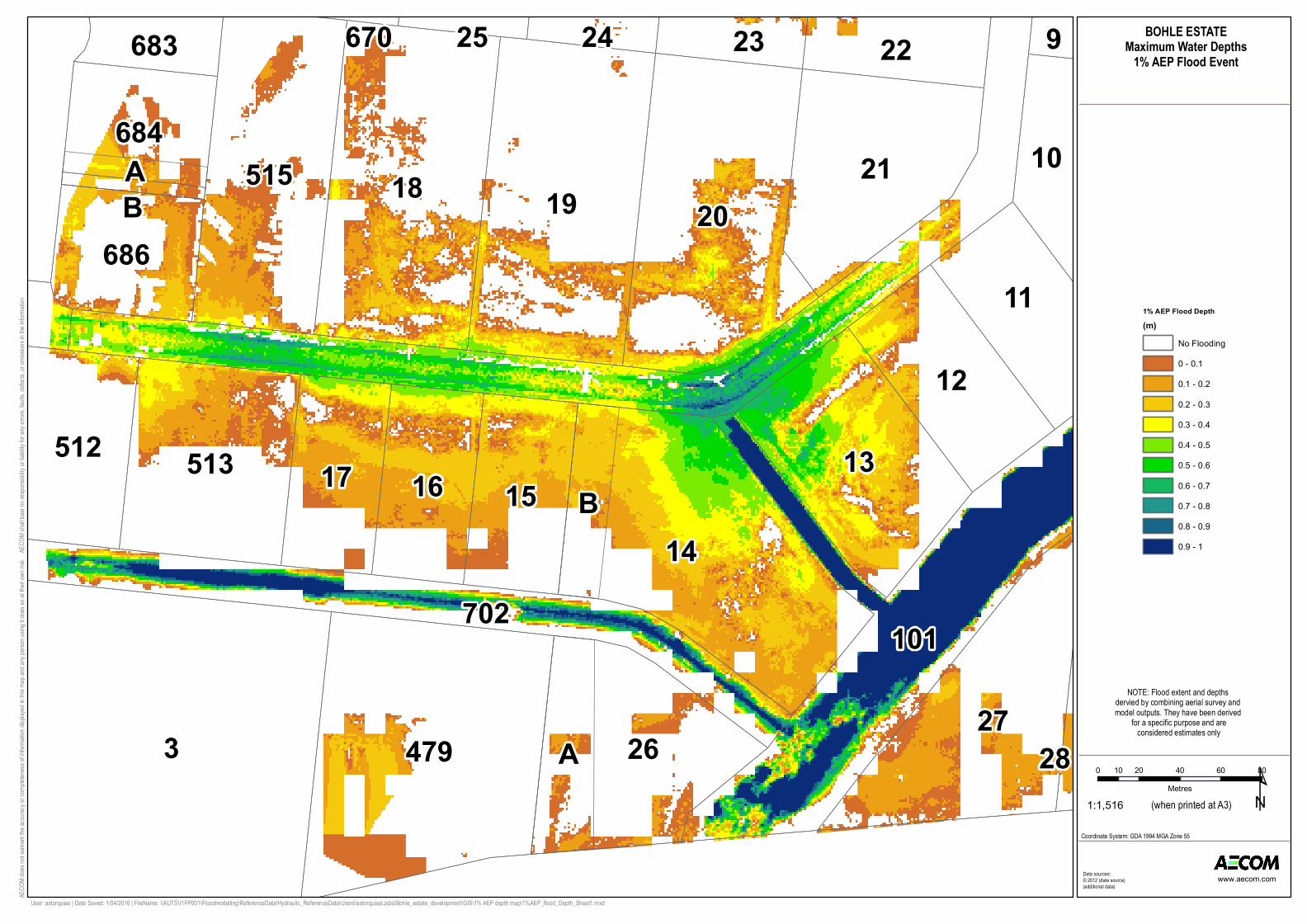
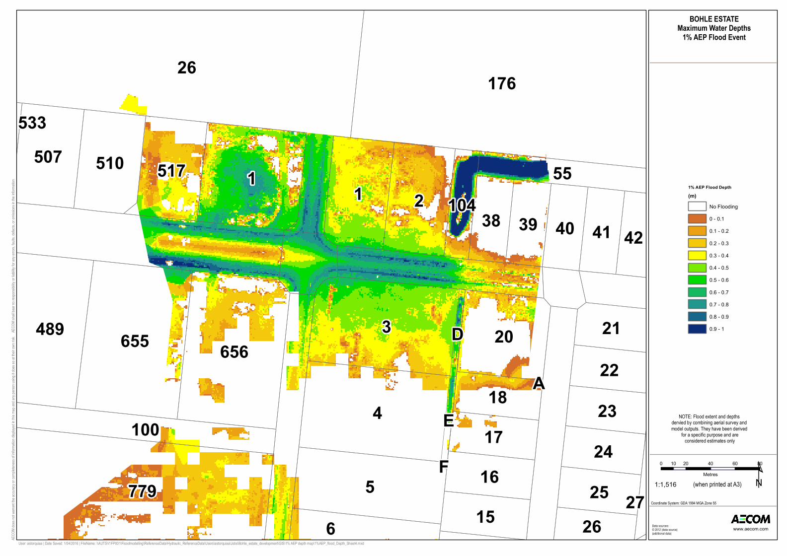
Bohle Estate Flood Mapping
The revised flood modelling was based on 10m resolution topographic grid derived from LiDAR data captured in 2012. To provide a more refined representation of design flood depths across the estate, detailed site survey was derived using updated aerial survey techniques, which has an improved vertical accuracy and resolution compared to the LiDAR data. The design flood level results from the citywide flood model for this area were overlaid on the detailed site topographic survey to derive potential design flood depth maps.
The associated flood maps provide a more refined representation of potential design flood depths across the estate. However, should accurate flood levels be required for building or layout design, we
Memorandum
To David Casey Page 1
CC
Subject Bohle Estate Design Flood Hazard Review
From Ashley Astorquia
File/Ref No. 60442620:T405/16:AXXA/DC Date 22-Nov-2016

p:\604x\60442620\2. correspondence\2.2 out\clerical\t405-16 bohle estate design flood review summary.docx 2 of 2
recommend revising the flood modelling using the detailed survey data and therefore the flood depths in these maps should be considered indicative only.
Limitations and Assumptions
This memo and associated mapping is based on flood level data available from Townsville City Council, at the time of preparation. No detailed assessment or verification of the flooding across the site has been undertaken by AECOM, beyond the mapping process described in the memo.
Any use which a third party makes of this document, or any reliance on or decision to be made based on it, is the responsibility of such third parties. AECOM accepts no responsibility for damages, if any, suffered by any third party as a result of decisions or actions made based on this document.
Where information has been supplied by the Client or other external sources, the information has been assumed correct and accurate unless stated otherwise. AECOM has made no independent verification of this information except as expressly stated. No responsibility is accepted by AECOM for incorrect or inaccurate information supplied by others.
3
14
191820
47927
101
26
13
21515
513
12
15
11
1617
A
512
684
686
B
22
10
23683 9
702
A
24
B
25
28
670
0 20 40 60 8010Metres ¹1:1,516 (when printed at A3)
BOHLE ESTATEMaximum Water Depths
1% AEP Flood Event
Data sources:© 2012 (data source)(additional data)
AECO
M does
not w
arrant
the ac
curacy
or com
pleten
ess of
informa
tion dis
played
in this
map a
nd any
perso
n usin
g it do
es so
at thei
r own ri
sk. A
ECOM
shall
bear no
respon
sibility
or liab
ility for
any e
rrors,
faults,
defec
ts, or o
missio
ns in t
he info
rmation
.
www.aecom.com
User: astorquiaa | Date Saved: 1/04/2016 | FileName: \\AUTSV1FP001\Floodmodelling\ReferenceData\Hydraulic_ReferenceData\Users\astorquiaa\Jobs\Bohle_estate_development\GIS\1% AEP depth map\1%AEP_flood_Depth_Sheet1.mxd
Coordinate System: GDA 1994 MGA Zone 55
1% AEP Flood Depth(m)
No Flooding0 - 0.10.1 - 0.20.2 - 0.30.3 - 0.40.4 - 0.50.5 - 0.60.6 - 0.70.7 - 0.80.8 - 0.90.9 - 1
NOTE: Flood extent and depths dervied by combining aerial survey and model outputs. They have been derived
for a specific purpose and are considered estimates only

2
6
10
14
282
101
4
3
20
127
19
26
13
2
9
211
1112
A
22
B
23
15
24
702
102 11479
B
10
A
A
A
K
BA
0 20 40 60 8010Metres ¹1:1,516 (when printed at A3)
BOHLE ESTATEMaximum Water Depths
1% AEP Flood Event
Data sources:© 2012 (data source)(additional data)
AECO
M does
not w
arrant
the ac
curacy
or com
pleten
ess of
informa
tion dis
played
in this
map a
nd any
perso
n usin
g it do
es so
at thei
r own ri
sk. A
ECOM
shall
bear no
respon
sibility
or liab
ility for
any e
rrors,
faults,
defec
ts, or o
missio
ns in t
he info
rmation
.
www.aecom.com
User: astorquiaa | Date Saved: 1/04/2016 | FileName: \\AUTSV1FP001\Floodmodelling\ReferenceData\Hydraulic_ReferenceData\Users\astorquiaa\Jobs\Bohle_estate_development\GIS\1% AEP depth map\1%AEP_flood_Depth_Sheet2.mxd
Coordinate System: GDA 1994 MGA Zone 55
1% AEP Flood Depth(m)
No Flooding0 - 0.10.1 - 0.20.2 - 0.30.3 - 0.40.4 - 0.50.5 - 0.60.6 - 0.70.7 - 0.80.8 - 0.90.9 - 1
NOTE: Flood extent and depths dervied by combining aerial survey and model outputs. They have been derived
for a specific purpose and are considered estimates only

779
4
6
2
22
5
8
7
9
23
10
2425
3
18 19 2120
100
656
670
655558 489
13
693
14
15
515
103
E
16
J
H
D
18
669
11
K
F
G
0 20 40 60 8010Metres ¹1:1,516 (when printed at A3)
BOHLE ESTATEMaximum Water Depths
1% AEP Flood Event
Data sources:© 2012 (data source)(additional data)
AECO
M does
not w
arrant
the ac
curacy
or com
pleten
ess of
informa
tion dis
played
in this
map a
nd any
perso
n usin
g it do
es so
at thei
r own ri
sk. A
ECOM
shall
bear no
respon
sibility
or liab
ility for
any e
rrors,
faults,
defec
ts, or o
missio
ns in t
he info
rmation
.
www.aecom.com
User: astorquiaa | Date Saved: 1/04/2016 | FileName: \\AUTSV1FP001\Floodmodelling\ReferenceData\Hydraulic_ReferenceData\Users\astorquiaa\Jobs\Bohle_estate_development\GIS\1% AEP depth map\1%AEP_flood_Depth_Sheet3.mxd
Coordinate System: GDA 1994 MGA Zone 55
1% AEP Flood Depth(m)
No Flooding0 - 0.10.1 - 0.20.2 - 0.30.3 - 0.40.4 - 0.50.5 - 0.60.6 - 0.70.7 - 0.80.8 - 0.90.9 - 1
NOTE: Flood extent and depths dervied by combining aerial survey and model outputs. They have been derived
for a specific purpose and are considered estimates only
26 176
4
3
1
779 5
21
655 656 20489
6
51751050755
18
1617
15252423
41403938
22
21
26
42
100
104
E
D
27
533
F
A
0 20 40 60 8010Metres ¹1:1,516 (when printed at A3)
BOHLE ESTATEMaximum Water Depths
1% AEP Flood Event
Data sources:© 2012 (data source)(additional data)
AECO
M does
not w
arrant
the ac
curacy
or com
pleten
ess of
informa
tion dis
played
in this
map a
nd any
perso
n usin
g it do
es so
at thei
r own ri
sk. A
ECOM
shall
bear no
respon
sibility
or liab
ility for
any e
rrors,
faults,
defec
ts, or o
missio
ns in t
he info
rmation
.
www.aecom.com
User: astorquiaa | Date Saved: 1/04/2016 | FileName: \\AUTSV1FP001\Floodmodelling\ReferenceData\Hydraulic_ReferenceData\Users\astorquiaa\Jobs\Bohle_estate_development\GIS\1% AEP depth map\1%AEP_flood_Depth_Sheet4.mxd
Coordinate System: GDA 1994 MGA Zone 55
1% AEP Flood Depth(m)
No Flooding0 - 0.10.1 - 0.20.2 - 0.30.3 - 0.40.4 - 0.50.5 - 0.60.6 - 0.70.7 - 0.80.8 - 0.90.9 - 1
NOTE: Flood extent and depths dervied by combining aerial survey and model outputs. They have been derived
for a specific purpose and are considered estimates only