Embed Size (px)
Citation preview
Megalopolis: An Assay for the Identification of the World Urban Mega-structures
ARELLANO, Blanca1 & ROCA, Josep2
Keywords: Urban sprawl; megalopolis; urban regions; metropolis
Abstract
The urban development of the twentieth century can be characterized by the rise of the
metropolitanization process. However, since 1950, it has occurred a real change of scale in this
growth: the infinite growth of metropolitan peripheries, encouraged by the process of urban
sprawl, has increased the urbanization of rural environments in the interstices between cities
and metropolitan areas. Previously isolated urban systems have been caught in the web of
urbanization and generated new urban spaces characterized by increasing complexity.
Megacities, intuited in the early twentieth century by precursors of contemporary urbanism
(Geddes, 1915; Mumford, 1938), have come true (Gottmann, 1961).
The objective of this paper is to perform an analysis for the identification and preliminary
characterization of megalopolis in the early twenty-first century. The recent publication by NASA
of planetary image of night lights gives the opportunity to proceed with the development of
methodologies for image analysis to identify susceptible urban mega-structures on a planetary
scale.
Literature review
Although most of the work oriented to identifying the megalopolitan agglomerations agrees to
use hybrid methodologies for delimitation, that combine understanding of the regional mega-
cities as places space as well as spaces of flows (Taylor, 2004; Lang and Dhavale, 2005), the true
is that few efforts (Hall et al, 1973) have been made in this sense, prevailing in the literature the
sectoral work. In this regard the main contributions have focused on four key methodologies,
depending on the determinant of analysis: functional relationships; the density of human
settlements; the morpholog of urban development, especially the contiguity of urbanization;
and, more diffuse, what we might be called local knowledge.
Gottmann's seminal work (1957 and 1961) is the first of these methodologies, with a
geographical and functional approach. Although Gottmann characterized the megalopolis of the
Northeast of USA as an almost continous stretch of urban and suburban areas, see Figure 1, it
didn’t define precisely the conurbation from a physical point of view. His approach was
functional, qualitative, as juxtaposition of metropolitan areas (which was defined by the Census
functional areas of daily commuting of residence / work). So, the notion of contact, coalescence
and overlap (Clawson, 1971; Hall et al, 1973) of functional metropolitan areas is the primary
factor that allows the identification of Megalopolis.
1Blanca Arellano. MSc. in Urban Management and Valuations. Researcher at the Center of Land Policy and Valuations (CPSV) Technical University of Catalonia (UPC). Email: [email protected] 2Josep Roca. PhD Director of the Center of Land Policy and Valuations (CPSV), Technical University of Catalonia (UPC). Email: [email protected]

Figure 1. The Megalopolis of Gottmann (1957)
That geographical and functional approach is adopted also for other jobs like the America 2050
or the European project POLYNET (Hall and Pain, 2006). In the words of Peter Hall:
“The Mega-City Region is then defined in terms of contiguous FURs3 , and is thus similar to the
so-called Consolidated Metropolitan Statistical Area (CMSA) used in the United States.
Contiguity is the sole criterion. There may be functional relations (cross-commuting) between
the constituent FURs, or there may not; this would emerge only in the course of the analysis.”
(Hall, 2009: 807)
The second approach to the definition of megalopolis is the analysis of the spatial patterns of
density of human settlements.
For Gottmann (1976) a superior average density to 250 inhabitants per sq km mark the border
to the delimitation of large urban regional agglomerations. However, megacities would be
characterized mainly by its polynuclear character, appearing between different urban centers
large undeveloped areas, making it difficult to use a predetermined standard density.
Morrill (2006), updated the work of Gottmann through the consideration of the Urbanized Areas
of the USA Census Bureau, which shows the evolution of the megalopolis of Boston-Washington
between 1950 and 2000 (Figure 2). The work of Morrill allows to see how the criterion density
is not an efficient mechanism for defining megacities. Not only because of the discontinuity of
densely populated areas, but the proliferation from the 70's of the phenomenon of ex-urban
sprawl.
3 Functional Urban Regions (FUR) were established since the late 60s, in the UK, as an application of the methodology of the US
Census Bureau adapted to the European reality (Royal Commission on Local Government in England, 1968; Hall et al, 1973; Hall y Hay, 1980; Cheshire y Hay, 1989).

Figure 2. Urbanized Areas in Boston-Washington Megalopolis
Source: Morrill (2006).
The third of the methodologies developed in the literature is the morphological approach, which
emphasizes continuity of development, materialized mainly from structural axes of
communication. This methodology is inspired by the first criteria that were developed for the
definition of the urban phenomenon in the era of metropolitan growth. Conurbations, once
gone beyond the administrative borders of the central city, came to be defined under strictly
physical criteria. Contiguity of urban growth is presented as well as the decisive factor for the
distinction between the city and its rural surroundings.
Currently, remote sensing technology allows information about ground covers sufficiently
precise, and therefore map the artificialised land. But they do not facilitate the detection of
complex structures such as the megalopolis, where tissues with very different degrees of
urbanization are interspersed with open spaces of rural character.
In parallel way, nocturnal images obtained by remote sensing, have represented an alternative
way to define megacities, and overall urban and metropolitan systems. From the pioneering
work of Elvidge et al (2001) it has been developed a number of studies, based on the information
generated with the nocturnal images. This approach has allowed not only to build an atlas of
artificial night lights as shown in Figure 3 (Cinzano et al, 2001), but has resulted in a consistent
literature that has generated the construction of indices for analysis human development
(Elvidge et al, 2012), the global distribution of economic activity (Ghosh et al, 2010), mapping of
GDP and CO2 emissions on a regional scale (Doll et al, 2000 and 2006) and very particularly, the
delimitation and characterization of urban agglomerations as shown in Figure 4 (Florida et al,
2008).
Figure 3. Nighttime lights and the urbanization in Nor
Source: Cinzano et al (2001).

Figure 4. European Megalopolis
Source: Florida et al (2008).
It can be concluded that the morphological methodology, from satellite imagery, are a useful
approach for identifying megalopolitan structures. However, given the extraordinary complexity
and plurality of forms of urban settlement along different continents, resulting from physical
settings (relief, hydrography, etc.) as well as different historical and cultural processes, it seems
inappropriate to use a criterion of continuity of urbanization such as the 200 meters usually used
to define urban agglomerations. Night lights represent a significant information for
understanding the megalopolitan phenomenon, although its implementation is still under
debate.
Finally, the fourth approach is a qualitative approach based on local knowledge. This
approach, which is certainly the most used in the literature, does not respond to specific
quantitative methodology, but responds to an intuitive vision, based on the professional
knowledge of urban planners. From this approach, the Lincoln Institute of Land Policy, together
with the Regional Planning Association and the Pennsylvania School of Design, developed in
2004, the proposal called Toward an America Spatial Development Perspective, which proposed
a qualitative change in the territorial management of United States that exceeds the merely
local (place, county), and even metropolitan proposing megalopolis as basic territorial scope of
planning.
Methodology
The present paper is part of the line that satellite images, especially those derived from the night
lights, represents the most useful contribution to the delimitation of megalopolis. So the
delimitation of the megalopolis on a global scale has been made by analyzing the image of night
lights that in 2013 NASA has published and called black marble, which has come to represent a
qualitative leap in our vision, from space, of urbanization phenomenon (Figure 5).

Figura 5. Black Marble, 2013
Source: NASA, Google Earth.
The methodology can be summarized in the following aspects:
- First we analyzed the file supplied by NASA, which offers, in the visible spectrum, three
images (RGB) differentiated from night lights. In this sense it has to proceed to the
composition of a single image in conventional greyscale palette (0-255), as can be seen in
Figure 6.
Figure 6. Nighttime Lights 2012
Source: Self prepared from NASA (2012).
- The image conversion from grayscale to elevations allows developing contours at different
intensity levels, capable of identifying different hypothesis of global cities. In this regard have
been tried different alternatives (see Figures 7 and following), which have led to adopt, at first,
the level curve on the intensity 64 (on ¼ of the light intensities analyzed 256).
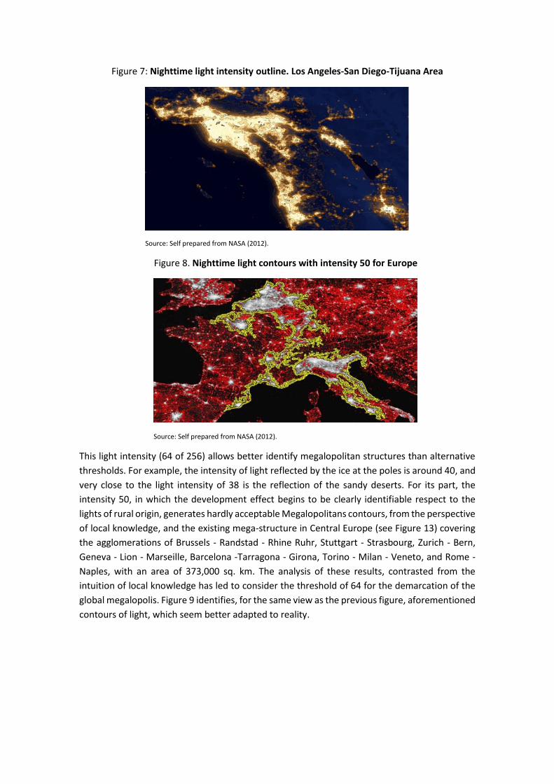
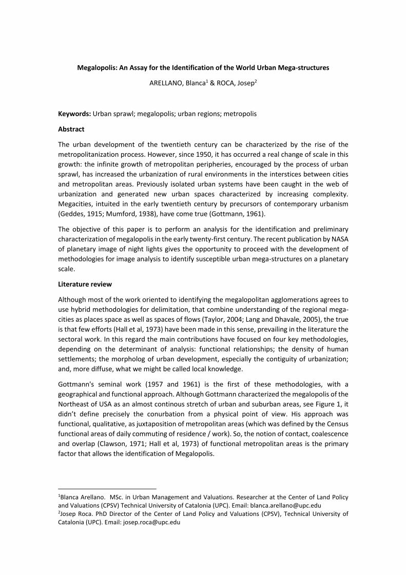
Figure 7: Nighttime light intensity outline. Los Angeles-San Diego-Tijuana Area
Source: Self prepared from NASA (2012).
Figure 8. Nighttime light contours with intensity 50 for Europe
Source: Self prepared from NASA (2012).
This light intensity (64 of 256) allows better identify megalopolitan structures than alternative
thresholds. For example, the intensity of light reflected by the ice at the poles is around 40, and
very close to the light intensity of 38 is the reflection of the sandy deserts. For its part, the
intensity 50, in which the development effect begins to be clearly identifiable respect to the
lights of rural origin, generates hardly acceptable Megalopolitans contours, from the perspective
of local knowledge, and the existing mega-structure in Central Europe (see Figure 13) covering
the agglomerations of Brussels - Randstad - Rhine Ruhr, Stuttgart - Strasbourg, Zurich - Bern,
Geneva - Lion - Marseille, Barcelona -Tarragona - Girona, Torino - Milan - Veneto, and Rome -
Naples, with an area of 373,000 sq. km. The analysis of these results, contrasted from the
intuition of local knowledge has led to consider the threshold of 64 for the demarcation of the
global megalopolis. Figure 9 identifies, for the same view as the previous figure, aforementioned
contours of light, which seem better adapted to reality.

Figure 9. Nighttime light contours with intensity 64 in Europe
Source: Self prepared from NASA (2012).
- The contours of light (2012) with intensity equal to or greater than 64 have allowed to identify
the lighted urban continuum, which have been aggregated into larger structures when there
contiguity per vertex, or separation of one pixel at most, as it can be seen from Figure 10, where
the agglomerations are shown, Boston (in white) and New York (in red).
Figure 10. Detail of the lighted contours with intensity 64 of New York and Boston
Source: Self prepared from NASA (2012).
- Finally, we have estimated the population of the continuing intensity contours 64 or higher by
overlapping information on population (2008) of the LandScan data base developed by the Oak
Ridge National Laboratory, USA. LandScan allows to analyze the population structure of different
environments in the urbanized planet, with a close approximation to the reality, as can be seen
in Figure 11 refers to the area of Calcutta. Overlapping the lighted contours with intensity 64
and the LandScan database (see Figure 12) has allowed to calculate the population of the same
area, identifying planetary megalopolis (2008-12).

Figure 11. Spatial distribution of the human population by LandScan database
Source: Self prepared from LandScan (2012).
Figure 12. Overlapping of the illuminated contours (64) and LandScan database
Source: Self prepared from LandScan (2012).
The calculation of the population has been made for all the illuminated urban continuous from
the previous methodology. This approach has allowed us to identify and characterize from a
demographic point of view the different types of human settlement on the planet, from the
villages, small towns and intermediate cities to the metropolitan and megalopolitan
agglomerations. In this sense, the megalopolitan proto-structures have been differentiated
(understood as the continuous illuminated with a population of over 5 million inhabitants), of
megacities themselves, identified from threshold population of 20 million.
Following the work begun by Florida et al (2008), using the methodology of nighttime satellite
images as a method for the delimitation of the megalopolis our analysis allows the worldwide
identification of 444,502 populated areas illuminated with sufficient intensity (64 on a scale of
256) for consideration of urban nature. 433 of these illuminated areas reach a population of
over one million inhabitants, concentrating 2,537 million inhabitants, 37.8% of the population
of the planet. 92 over 5 million represent the seeds of megalopolitan structures. And 30
structures, that we call proto-megas, exceed 15 million, reaching a population of 1,298,757,300
inhabitants, placing as strong candidates to be characterized as megalopolis.
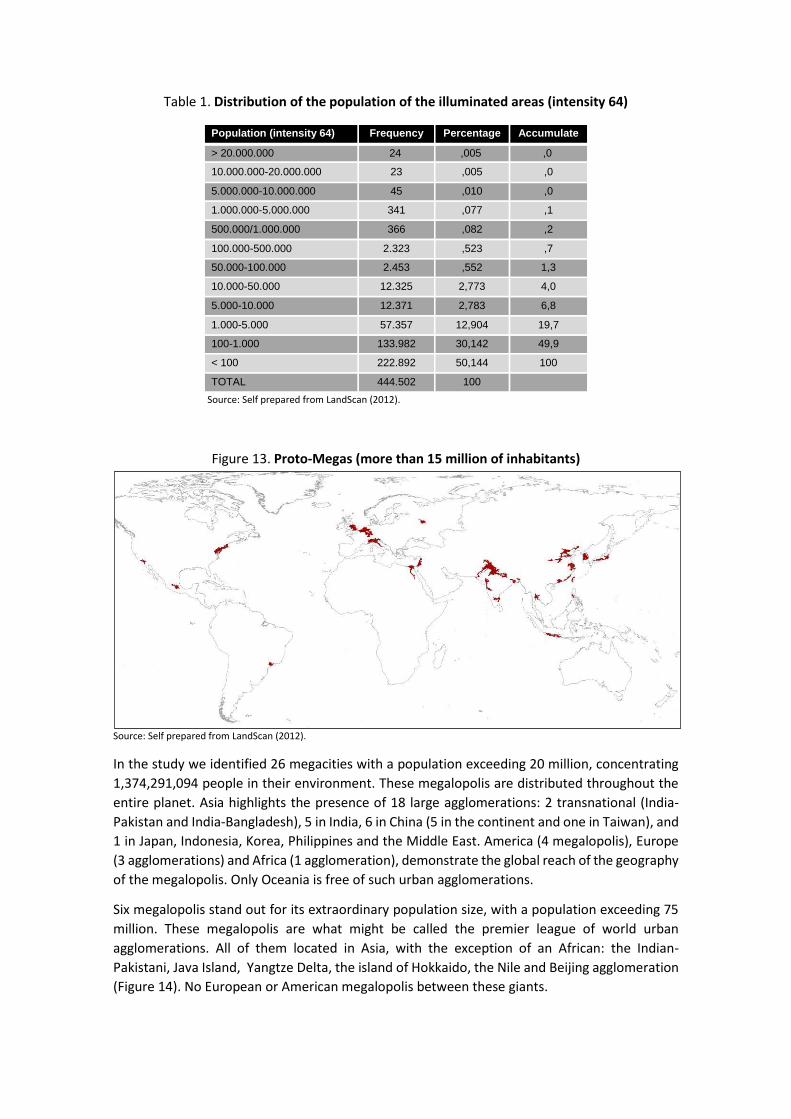
Table 1. Distribution of the population of the illuminated areas (intensity 64)
Population (intensity 64) Frequency Percentage Accumulate
> 20.000.000 24 ,005 ,0
10.000.000-20.000.000 23 ,005 ,0
5.000.000-10.000.000 45 ,010 ,0
1.000.000-5.000.000 341 ,077 ,1
500.000/1.000.000 366 ,082 ,2
100.000-500.000 2.323 ,523 ,7
50.000-100.000 2.453 ,552 1,3
10.000-50.000 12.325 2,773 4,0
5.000-10.000 12.371 2,783 6,8
1.000-5.000 57.357 12,904 19,7
100-1.000 133.982 30,142 49,9
< 100 222.892 50,144 100
TOTAL 444.502 100
Source: Self prepared from LandScan (2012).
Figure 13. Proto-Megas (more than 15 million of inhabitants)
Source: Self prepared from LandScan (2012).
In the study we identified 26 megacities with a population exceeding 20 million, concentrating
1,374,291,094 people in their environment. These megalopolis are distributed throughout the
entire planet. Asia highlights the presence of 18 large agglomerations: 2 transnational (India-
Pakistan and India-Bangladesh), 5 in India, 6 in China (5 in the continent and one in Taiwan), and
1 in Japan, Indonesia, Korea, Philippines and the Middle East. America (4 megalopolis), Europe
(3 agglomerations) and Africa (1 agglomeration), demonstrate the global reach of the geography
of the megalopolis. Only Oceania is free of such urban agglomerations.
Six megalopolis stand out for its extraordinary population size, with a population exceeding 75
million. These megalopolis are what might be called the premier league of world urban
agglomerations. All of them located in Asia, with the exception of an African: the Indian-
Pakistani, Java Island, Yangtze Delta, the island of Hokkaido, the Nile and Beijing agglomeration
(Figure 14). No European or American megalopolis between these giants.

Figure 14. Premier League
Source: Self prepared from NASA-NOAA (2012) and LandScan (2012).
Faced with these giants it appears a second group of megacities (see Figure 22) which is led by
the large conurbation of Central Europe, which stretches from Brussels Dutch Randstad, the
Rhine-Ruhr, Strasbourg and Stuttgart. Europe completes its presence with English megacities
(London to Cardiff and Bristol on the one hand, and Birmingham, Sheffield, Manchester,
Liverpool and Leeds on the other), on the fourteenth place, and the vast agglomeration of
northern Italy, which It extends from Milan to Venice, in the twenty-first. With regard to
America, the megalopolis par excellence, the US Northeast (Boston - New York - Philadelphia -
Baltimore - Washington), does not appear until the tenth place ranking, preceded by the two
large Chinese structures Zhengzhou- Pearl River Xian. The rest of American megalopolis is
reduced to other giant, the large urban agglomeration round the city of Mexico, which only
appears in the fifteenth place, relegating Sao Paulo - Santos seventeenth, and other great
American agglomeration of Los Angeles - San Diego - Tijuana (Southern California), which is the
penultimate of the 26 megacities obtained in the present work.

Figure 15. European and American Megalo
Source: Self prepared from NASA-NOAA (2012) and LandScan (2012).
Conclusions
It can be concluded that megacities are a new form of urban settlement that affects the entire
planet. This fact is not a phenomenon exclusive of the first world versus what the pioneering
work of Geddes, Mumford and Gottmann seemed to suggest. Latin America, Africa and
especially Asia, are also protagonists of these new forms of occupation of space. Emerging urban
territories that seem to make out a new economic and social order in Europe, and North America
will no longer have the unique role of protagonists.
References
ARELLANO, B y ROCA, J. LAS MEGAESTRUCTURAS URBANAS DEL SIGLO XXI: UN ENSAYO PARA LA IDENTIFICACIÓN Y
CARACTERIZACIÓN DE LAS MEGALÓPOLIS. ACE: architecture, city and environment - Year 09, num. 25 June, 2014.
ARELLANO, B. y ROCA, J. El Urban Sprawl, ¿Un Fenómeno de Alcance Planetario? Los Ejemplos de México y España. En: ACE
(Arquitectura, Ciudad y Entorno), 4 (12): 115-147, 2010.
ARELLANO, B. y ROCA, J. Sprawl en las metrópolis europeas. Las periferias metropolitanas, ¿principal escenario de la dispersión de
la urbanización en Europa? En: ACE (Arquitectura, Ciudad y Entorno), 7 (20): 95-114, 2012.
ASCHER, F. Metápolis ou l’avenir des villes. París, Odile Jacob, 1995.
BAUER, G. y ROUX, J.M. La rurbanization, ou la ville éparpillée. París, Ed. du Seuil, 1976.
BERRY, B. The Counterurbanization Process: Urban American since 1970 en su Urbanization and Counterurbanization, Beverly Hills,
Sage, 1976.
CARBONELL, A. e YARO, R.D. American Spatial Development and the New Megalopolis. En: Land Lines, Lincoln Institute of Land
Policy, 17 (2), April 2005.
CHESHIRE P.C. y HAY D.G. Urban Problems in Western Europe: An Economic Analysis. Londres, Unwin Hyman, 1989.
CINZANO, P.; FALCHI, F. y ELVIDGE, C.D. The first World Atlas of the artificial night sky brightness. En: Mon. Not. R. Astron. Soc., 328:
689-707, 2001.
CLAWSON, M. Suburban Land Conversion in the United States: An Economic and Governmental Process. , Routledge, 1971.
DEWAR, M. y EPSTEIN, D. Planning for ''Megaregions'' in the United States”. En: Journal of Planning Literature, 22: 108, 2007.
DEMATTEIS, G. Suburbanización y periurbanización. Ciudades anglosajonas y ciudades latinas. En: La ciudad dispersa.
Suburbanización y nuevas periferias. Barcelona, Centro de Cultura Contemporánea de Barcelona, 1998
DOLL, C.N.H.; MULLER, J.P. y ELVIDGE, C.D. Night-time imagery as a tool for global mapping of socio-economic parameters and
greenhouse gas emissions. En: Ambio, 29 (3): 157-162, 2000.
DOLL, C.N.H.; MULLER, J.P. y MORLEY, G.J. Mapping regional economic activity from night-time light satellite imagery. En: Ecological
Economics, 57: 75-92, 2006.
ELVIDGE, C.D.; IMHOFF, M.L.; BAUGH, K.E.; HOBSON, V.R.; NELSON, I.; SAFRAN, J.; DIETZ, J.B. y TUTTLE, B.T. Night-time lights of the
world: 1994-1995”. En: ISPRS Journal of Photogrammetry & Remote Sensing, 56: 81-99, 2001.
ELVIDGE, C.D.; BAUGH, K.E.; ANDERSON, S.J.; SUTTON, P.C. y GHOSH, T. The Night Light Development Index (NLDI): a spatially explicit
measure of human development from satellite data. En: Social Geography, 7: 23-35, 2012.
EC. European Comission. European Spatial Development Perspective. Towards Balanced and Sustainable Development of the
Territory of the European Union. , 1999.
FISHMAN, R. America’s New City. En: The Wilson Quaterly, 14, 1990.
FISHMAN, R. The American Planning Tradition. FISHMAN, R. (Ed.) The American Planning Tradition: Culture and Policy. Washington
D.C., The Woodrow Wilson Center Press, 2000
FRIEDMANN, J. The World City Hypothesis. Development and Change, 17: 69-83, 1986.
FLORIDA, R.; GULDEN, T. y MELLANDER, C. The rise of the mega-region. En: Cambridge Journal of Regions, Economy and Society, 1:
459-476, 2008.
GEDDES, P. Cities in Evolution. Londres, Williams and Norgate, 1915.
GHOSH, T.; POWELL, R.L.; ELVIDGE, C.D.; BAUGH, K.E.; SUTTON, P.C. y ANDERSON, S. Shedding Light on the Global Distribution of
Economic Activity. En: The Open Geography Journal, 3: 148-161, 2010.
GOTTMANN, J. Megalopolis or the Urbanization of the Northeastern Seaboard. En: Economic Geography, 33 (3): 189-200, 1957.
GOTTMANN, J. Megalopolis: the urbanized northeastern seaboard of the United States. New York, Twentieth Century Fund. 1961.
GOTTMANN, J. Megalopolitan systems around the world. En: Ekistics, 243: 109-113, 1976.
HALL, P. The World Cities. Londres, World University Library, Weidenfeld & Nicolson, 1966.
HALL, P. y HAY, D. Growth Centres in the European Urban System. Londres, Heinemann, 1980.

HALL, P. Looking Backward, Looking Forward: The City Region of the Mid-21st Century. En: Regional Studies, 43 (6): 803-817, 2009.
HALL, P. y PAIN, K. The Polycentric Metropolis. Learning from Mega-city Regions in Europe. Londres, Earthscan, 2006.
HALL P.; THOMAS R.; GRACEY H. y DREWETT R. The Containment of Urban England (2 volúmenes). Londres, George Allen & Unwin,
1973.
KERN County Council of Governments, San Diego Association of Governments and Southern California Association of Governments:
The Southern California Mega-region A Case Study of Global Gateway Regions: America’s Third Century Strategy. September 2005.
KRUGMAN, P.R. The Self Organizing Economy. , Blackwell Publishers, 1996.
HARVEY, D. Cities or urbanization? City. Analysis of Urban Trends Culture, Theory, Policy Action, 1-2, 1996.
HEALEY, P. City Regions and Place Development. Regional Studies, 43 (6): 831-843, 2009.
LANG, R.E. y DHAVALE, D. Beyond Megalopolis: Exploring America’s New ‘‘Megapolitan’’ Geography (Census Report 05:01). VA,
Metropolitan Institute at Virginia Tech, 2005.
LANG, R.E. y KNOX, P.K. The New Metropolis: Rethinking Megalopolis. Regional Studies, 43 (6): 789-802, 2009.
LUCAS, R. On the mechanics of economic development. Journal of Monetary Economics, 22: 3-42, 1988.
MORRILL, R. Classic Map Revisited: The Growth of Megalopolis. En: The Professional Geographer, 58 (2): 155-160, 2006.
MUMFORD, L. The Culture of Cities. Nueva York, Harcourt. Brace & world, 1938. p.
NASA. Night Lights 2012 - Flat map [en línea] Fecha de consulta: . Disponible en: <http://visibleearth.nasa.gov/view.php?id=79765>.
2012.
NEUMAN, M. y HULL, A. The Futures of the City Region. Regional Studies, 43 (6): 777-787, 2009.
NUREC. Network on Urban Research in the European Community. Atlas of Aglomerations in the European Union. Duisburg, NUREC,
1994.
ORNL. Oak Ridge National Laboratory. Landscan [on line] <http://web.ornl.gov/sci/landscan/>. 2012.
SASSEN, S. The Global City: New York, London, Tokyo. Princeton, Princeton University Press, 1991.
RPA. Regional Plan Association. America 2050: Megaregions [on line]. Available in: http://www.america2050.org/megaregions.html
RPA. Regional Plan Association. America 2050: A Prospectus. Nueva York, 2006.
RPA. Regional Plan Association. Toward an American Spatial Development Perspective. Nueva York, 2004.
ROY, A. The 21st-Century Metropolis: New Geographies of Theory. Regional Studies, 43 (6): 819-830, 2009.
SCOTT, H.J.; SOJA, E.W. y STORPER, M. Global City-Regions. SCOTT, A. (Ed.) Global City-Regions. Trends, Theory, Policy. Oxford,
Oxford University Press, 2001.
TAYLOR P.J. World City Network: A Global Urban Analysis. Nueva York, Routledge, 2004.
TUROK, I. Limits to the Mega-City Region: Conflicting Local and Regional Needs. Regional Studies, 43 (6): 845-862, 2009.
VAN DEN BERG, L. Urban Europa: A study of Urban Growth and Decline. Pargamon, Oxford, 1982.
WHEELER, S. Regions, Megaregions, and Sustainability. Regional Studies, 43 (6): 863-876, 2009.


![[Book Review] Megalopolis: Contemporary Cultural](https://img.dokumen.tips/doc/110x75/61bd120861276e740b0f0c3f/book-review-megalopolis-contemporary-cultural-.jpg)